Embed Size (px)
Citation preview

Peachtree CorridorPrepared by: Urban Collage, Inc. in association with
Cooper Carry, URS Corp., ZVA, ZHA, HPE, Verge Studios, Biscuit Studios and PEQ
SUMMARY REPORT
October 2004
SUMMARY REPORT
October 2004
PeachtreeFocus Area
Prepared by:Urban Collage, Inc.
Cooper Carry, URS Corp., ZVA, ZHA, HPE, Verge Studios, Biscuit Studios and PEQ
PeachtreeFocus Area
CentralAtlantaProgress
AtlantaDowntown
ImprovementDistrict
City of
Atlanta

Peachtree CorridorPrepared by: Urban Collage, Inc. in association with
Cooper Carry, URS Corp., ZVA, ZHA, HPE, Verge Studios, Biscuit Studios and PEQ
Overview
The Peachtree Corridor forms the physical and symbolic backbone of Downtown Atlanta. In January through March of 2004, the Corridor was studied as one of fi ve targeted Focus Areas included in the “Imagine Downtown” planning and visioning process. A Peachtree Corridor Core Team stakeholder group of institutions, businesses, property owners and residents in the area was convened to review existing conditions, defi ne issues for discussion, review plan products and prioritize implementation steps. In addition, one-on-one interviews were held with many of the stakeholders in the corridor and over 150 people participated in the Community Workshop held on February 17, 2004.
Focus Area Context
The Peachtree Corridor Focus Area stretches from Martin Luther King, Jr. Drive on the south to North Avenue on the north. This linear corridor includes all properties within three blocks east and west of Peachtree Street itself and includes major landmarks such as the Five Points MARTA Station, Underground Atlanta, Fairlie-Poplar, Woodruff Park, Andrew Young International Boulevard, Peachtree Center, Mayor’s Park, Crawford-Long Hospital and several major Downtown churches, offi ce buildings and hotels.
The Peachtree Corridor is unique in that it also overlaps three other Imagine Focus Areas: JSA-McGill, Eastside-Auburn, and South CBD. The recommendations that were the outcome of each individual process were also included in Peachtree for stakeholder and public validation.
Stakeholders / Dominant Issues
Over the course of several weeks, one-on-one interviews were conducted with members of the Core Team to fl esh out the most pressing issues affecting the Peachtree Corridor. The issues were organized in a matrix broken into seven categories, revealing hot discussion topics and areas of heightened interest and concern. Of the seven categories, economic development and transportation were foremost in the minds of Core Team members. Retail feasibility along Peachtree dominated economic development, with specifi c attention given to attracting new retail, extending existing retail hours, and retooling the street vending program. Better transit and improvements to both MARTA stations and operations dominated the transportation category.
Although there was some discussion on issues related to social services, it was directed toward the ongoing diffi culties with panhandling and perceptions surrounding the homeless. These concerns were countered in part by the stepped-up police efforts to deter panhandling, and the imminent construction of the 24/7Homeless Resource Center in the South CBD. Much of the discussion originated due to the effect of panhandling on tourism and the housing market; in fact, increasing housing was a major priority for the Core Team.
Design, and to some degree historic preservation, also emerged as dominant issues. People generally felt that Peachtree is the signature street of Atlanta and should refl ect this in its appearance. Although Peachtree has streetscaping improvements dating from the 1996 Olympics, many Core Team members felt that either it was poorly maintained or not as visible or spectacular as it could be. Equally, all Core Team members felt that prominent historic structures like Macy’s (181 Peachtree), the Medical Arts Building, and the Winecoff Hotel were signifi cant assets that deserved signifi cant attention.
OVERVIEW / ISSUES
1

Peachtree CorridorPrepared by: Urban Collage, Inc. in association with
Cooper Carry, URS Corp., ZVA, ZHA, HPE, Verge Studios, Biscuit Studios and PEQ 2
OVERVIEW / ISSUES The Focus Area
The Peachtree Corridor Focus Area extends almost the entire distance of Downtown Atlanta, from North Avenue to the north of Martin Luther King Jr. Drive on the south. Some of the major elements include:
Atlanta Civic CenterThe Civic Center anchors the east side of the focus area with a 4,600 -seat auditorium and 5,800 square feet of meeting space
Centennial ParkThe premier public space in Down-town is emerging as the center of attractions like the Georgia Aquarium and World of Coca-Cola
Land Use
EconomicDevelopment
Peachtree a destination unto itself; discussion over privileging residents or conventioneers; exploit ‘window of op-portunity’ of aquarium; promote arts facilities; tax incentives for retailers; importance of marketing; revamp street vending
Housing
Historic/Natural Resources
Transportation
SocialServices
Urban Design
Few vacant parcels; ‘right’ mix of retail is important; retail desirable at MARTA stations but unresolved; current World of Coca-Cola structure is open for discussion
New housing a priority; several key developments pending; consider housing overbuild for Five Points MARTA station; existing Downtown residents want longer retail hours
Peachtree’s history an asset, with many remaining buildings and sites; Macy’s a landmark but needs a prominent use; continued interest in Winecoff Hotel and Medical Arts Building
Interest in better surface transit, (ex. circulator, trolley); enhance and maintain MARTA station portals; extend MARTA service hours; zone system for MARTA and taxi fares; jaywalking may be a problem; include International in plan; perception of cost and availability of parking
Panhandlers and homeless deter visitors; although improving, need enforcement of cruising, panhandling, and feeding ordinances
Peachtree should be a ‘Great Street’; existing streetscape lacks ‘punch’; coordinate improvements with opening of aquarium; improve aesthetics of Five Points MARTA station; connectivity to Capitol important; coordinate w/ proposed zoning changes
The Issues MatrixOne-on-one stakeholder interviews and open forums with the Core Team produced the set of priority issues listed in the matrix below:
Fairlie-PoplarOne of the oldest areas in Atlanta, Fairlie-Poplar contains the largest concentration of historic commercial structures in the city
Underground AtlantaRestaurants, nightclubs and shops all tucked under the series of viaducts constructed over the railroad ‘gulch’

Peachtree CorridorPrepared by: Urban Collage, Inc. in association with
Cooper Carry, URS Corp., ZVA, ZHA, HPE, Verge Studios, Biscuit Studios and PEQ
Existing Conditions Analysis
Each focus area was subject to an initial physical analysis before convening the Core Team. The analysis utilized GIS information derived from Fulton County tax records and the City of Atlanta, as well as, new information and verifi cation provided by fi eld surveys. The intent of the analysis was to provide the Core Team with a compact picture of the area from which to begin a discussion, and to determine strengths, weaknesses, assets and liabilities in the physical environment that may not be apparent to the Core Team. The analytical maps, along with the list of stakeholder issues, became the staring point for the public consensus-building process during Charette Week.
Land Use
A physical conditions assessment was made of all properties within the study area. The Peachtree Corridor (569 parcels containing 272 acres), like much of Downtown, includes a diverse mix of institutions, businesses, parking structures, and an increasing amount of residences. Existing residential uses, all multi-family, are concentrated in Fairlie-Poplar and the eastern side of “SoNo” near the Civic Center and are predominantly mid-rise. Surprisingly, the area includes several vacant lots, unoccupied buildings and numerous surface parking lots amounting to 54 acres (20%.) High-density commercial uses are focused on Peachtree Street, particularly from Woodruff Park to Hardy Ivy Park. Lower density offi ce and commercial is scattered through Fairlie-Poplar, Lower Peachtree and SoNo. The central portion of the study area forms the Hotel District, particularly east of Peachtree Street. The area includes (5) existing parks- Woodruff Park, Hurt Park, Spring-Walton Park, Hardy-Ivy Park and Mayor’s Park.
Zoning
Most of the study area falls within the existing Special Public Interest District (SPI) #1, a mixed-use district that covers most of Downtown. The northernmost portion, SoNo, is presently part of the North Avenue SPI-2 and “C-4” and “C-5” commercial zoning districts. Recently, Central Atlanta Progress and the City of Atlanta have led an effort to update and refi ne the zoning for Downtown Atlanta to encourage mixed-use development, walkability and quality design. The “Downtown Livability Code” establishes general urban design standards for the entire corridor, but allows for use, bulk and density differences through Subarea requirements. The majority of the Peachtree Corridor falls within the proposed central “Downtown Core,” but portions of the Terminus, Fairlie-Poplar, Olympic Park Park North and West & East SoNo Subareas are also included in the study area.
EXISTING CONDITIONS: LAND USE & ZONING
3

Peachtree CorridorPrepared by: Urban Collage, Inc. in association with
Cooper Carry, URS Corp., ZVA, ZHA, HPE, Verge Studios, Biscuit Studios and PEQ 4
EXISTING CONDITIONS
EXISTING ZONING
Existing Land Use Highlights:• High-density commercial along
Peachtree Street• Parking facilities on blocks adjacent
to Peachtree• Major institutional uses including
Crawford Long Hospital and Geor-gia State University
• Residential uses are relatively scarce
EXISTING LAND
Existing Zoning Highlights:• Entire Peachtree Corridor falls within
current SPI-1 and SPI-13 Districts• Proposed Downtown Livability Code
(DLC) is in the approval process• DLC strives to take provisions of
existing “quality-of-life” districts and apply them to Downtown
• DLC maintains the higher densities normally associated with downtown development
• DLC provides for new streetscape standards

Peachtree CorridorPrepared by: Urban Collage, Inc. in association with
Cooper Carry, URS Corp., ZVA, ZHA, HPE, Verge Studios, Biscuit Studios and PEQ
Peachtree Street forms the transportation spine of Atlanta, stretching from Downtown to Midtown to Buckhead and beyond. To both the west and east of the Peachtree Ridge are one-way “workhorse” street pairs, Spring/Williams and Piedmont/Courtland. Major east-west connections include Martin Luther King, Marietta/Decatur, International, Alexander/McGill and North Avenue. Within the Peachtree Corridor, an overall goal of balanced circulation, including transit, bicycles, vehicles and pedestrians has been established. An assessment of the existing circulation facilities in this light includes assets, as well as areas for future improvement.
Street Hierarchy:The analysis of the street hierarchy is based on roadway widths, sidewalk widths, existing development character and vehicular speeds. Existing thoroughfares include the north-south streets of Courtland, Piedmont, Spring, Williams, Peachtree Center and Centennial Olympic Park Drive, and the east-west streets of Martin Luther King, McGill and North, which serve a major role in traffi c fl ow within Downtown. The majority of streets, including Peachtree, Andrew Young International and Decatur, are classifi ed as “Avenues”, heavily traveled by pedestrians and containing active street level activity and, often, on-street parking. Minor Streets, such as Baker and Alexander, and residentially oriented Neighborhood Streets, such as Currier and Poplar, round out the majority of the existing street network.
Transit, Sidewalks and Bicycle Facilities:The vehicular grid in the corridor is reinforced by a network of transit options. Well-served by trains and buses, most of the study area is within walking distance (i.e. a fi ve minute walk) of the area MARTA Stations; Georgia Regional Transportation Authority (GRTA) regional commuter buses currently embark and debark at the Civic Center station. The City’s ‘Commuter On-street Bike Plan’ identifi es Luckie Street as a potential bike path connecting Georgia Tech to Downtown. The JSA-McGill corridor and Baker Street have also been identifi ed for a proposed bike path connecting to the Freedom Parkway trail. Although the corridor has a good network of streets, sidewalks in certain parts are in substandard condition. Atlanta’s hilly terrain also makes pedestrian movement diffi cult in places. Finally, several longer blocks of Peachtree with signifi cant pedestrian traffi c present dangerous conditions for pedestrians making mid-block movements.
Traffi c Signals:Given Downtown’s complex street grid, traffi c signalization and timing are an important issue in the study area. As the area develops into a mixed-use center with new offi ce and residential uses, a detailed traffi c study will be required to maintain the vehicular fl ow while supporting the additional pedestrian activity within the corridor.
Parking:As described in the land use section, surface parking lots occupy 47 acres of land within the study area. They are mainly concentrated between Centennial Olympic Park Drive and Peachtree Street and east of Peachtree Center Avenue. Some of these surface parking lots have proposals for new developments currently under review. There are 50 existing parking structures within the corridor, but new development will likely necessitate the construction of several more associated structures.
Urban Design:The urban design analysis map is a compilation of urban design observations in the Peachtree Corridor. The Peachtree Street ridge connects several surrounding districts and dominates the area physically, but presents walkability challenges on east-west streets. The magnitude and speed of vehicular movement on many streets, particularly the one-ways, presents additional challenges. The study area is physically bisected by the Downtown Connector at Mayor’s Park. Historic commercial buildings, including the Flatiron Building, the Candler Building, the Winecoff and the Medical Arts Building, are arrayed along Peachtree and throughout Fairlie-Poplar and major public artworks enliven the character of Peachtree’s many parks and plazas.
EXISTING CONDITIONS: CIRCULATION & URBAN DESIGN
5

Peachtree CorridorPrepared by: Urban Collage, Inc. in association with
Cooper Carry, URS Corp., ZVA, ZHA, HPE, Verge Studios, Biscuit Studios and PEQ 6
CIRCULATION & URBAN DESIGN
EXISTING URBAN DESIGN ISSUES
Existing Circulation Highlights:• Peachtree Street is the principal
artery and is well-served by transit, (bus and rail)
• Peachtree largely considered a processional street or as an origin for wayfi nding
• Traffic-carrying capacity occurs on fl anking north-south streets (like Courtland and Spring)
• East-west mobility is conditioned by several one-way streets
• Peachtree’s pedestrian environ-ment varies in dimension and quality, creating diffi culties for pedestrian movement
EXISTING CIRCULATION ISSUES
Existing Urban Design Highlights:• Peachtree Street’s origins lie in Na-
tive American trails running along a continuous ridge
• The ridge is still a factor in the strenu-ous climb for pedestrians
• Several important historic buildings remain along Peachtree, although some are vacant and in need of restoration
• Peachtree is host to installations of public art and streetscapes that remain from the 1996 Olympics
• Peachtree has high-quality open spaces (Hardy Ivy Park, Woodruff Park and Underground Plaza)
• Plazas surrounding Five Points MARTA station are barricaded from entry
• Retail concentrations occur at Peachtree Center and the area around Underground, most of which is internalized and concealed from view

Peachtree CorridorPrepared by: Urban Collage, Inc. in association with
Cooper Carry, URS Corp., ZVA, ZHA, HPE, Verge Studios, Biscuit Studios and PEQ
The Imagine Downtown process has included an overall Downtown “benchmarking” study establishing the market potential of Downtown, as well as specifi c market analyses of each Focus Area. Key fi ndings of the market analyses carried out by ZHA, Inc. and Zimmerman-Volk and Associates for the Peachtree Corridor Focus Area include:
Retail Market Highlights: • Approximate potential demand of 140,000 to 300,000 sq. ft. by 2010
• Eating & Drinking 50,000-80,000 sq. ft. • Shoppers Goods 80,000-200,000 sq. ft. • Convenience Stores 12,000-15,000 sq. ft.
Eating and drinking — currently focus on workday eating and visitors; does not draw from outside of captive markets. Success depends on a creation of destinations – building on Fairlie-Poplar, filling out spaces on streets perpendicular to Peachtree, considering an anchor (40,000+sq. ft.) “eatertainment” facility (‘Jillians’ as example), possibly for the Macy’s Building. Shoppers Goods — Relies on the massing of like stores; currently for captive market only. Near-term expansion of this store type could include up to 60,000 square feet; could include a ”mini-anchor” store such as a Filene’s Basement or similar that does not require department store volume. With fortifi ed residential base, major constraint is physical; with competition from Atlantic Station and expensive downtown land costs, large assemblages would be diffi cult. New opportunities exist along Andrew Young International Boulevard. Convenience Retail —Notable lack of convenience goods in the Peachtree Corridor; area is currently capturing an extremely small amount of the market share for convenience goods. Aside from Publix on Piedmont, very little space within the district. Addition of between 12,000-15,000 square feet of space would capture closer to the ideal amount from captive markets.
Offi ce Market Highlights: • Approximately 20,000,000 sq. ft. of existing offi ce space in Downtown • Per Atlanta Regional Commission employment projections, Fulton County will require
an additional 16,172,243 sq. ft. of offi ce space by 2010 • Downtown could realize 10% to 20% of overall demand by 2010, or 887,00 to 2,216,00
square feet • Peachtree Corridor, as premier Downtown offi ce location, is constrained by physical
limits on development parcels • Available land on International Boulevard could support a Class-A building with 300,000
to 600,000 square feet
Housing Market Highlights: • Total Downtown demand of 7,800 units in next seven years • For Peachtree Focus Area - • Target residential mix, multifamily product exclusively: 990 (42%) potential buyers / 1,370
(58%) potential renters per year to 2010 • Potential market by type: 36% Empty Nesters, 7% Traditional / Non-Traditional Families,
57% Young Singles / Couples • Potential demand for up to 1,600 units by 2010 (12% capture rate) 284 units per year
absorption
Major development opportunities are located throughout SoNo, near Mayor’s Park and Centennial Hill, along International Boulevard (particularly near Centennial Olympic Park) and John Wesley Dobbs Avenue and scattered through Fairlie-Poplar and the Underground/Five Points areas. Peachtree Street itself includes several unoccupied retail storefronts that present opportunities for new street level retail uses, most notably the former Macy’s at Ellis Street.
EXISTING CONDITIONS: DEVELOPMENT OPPORTUNITIES
7
Peachtree CorridorPrepared by: Urban Collage, Inc. in association with
Cooper Carry, URS Corp., ZVA, ZHA, HPE, Verge Studios, Biscuit Studios and PEQ 8
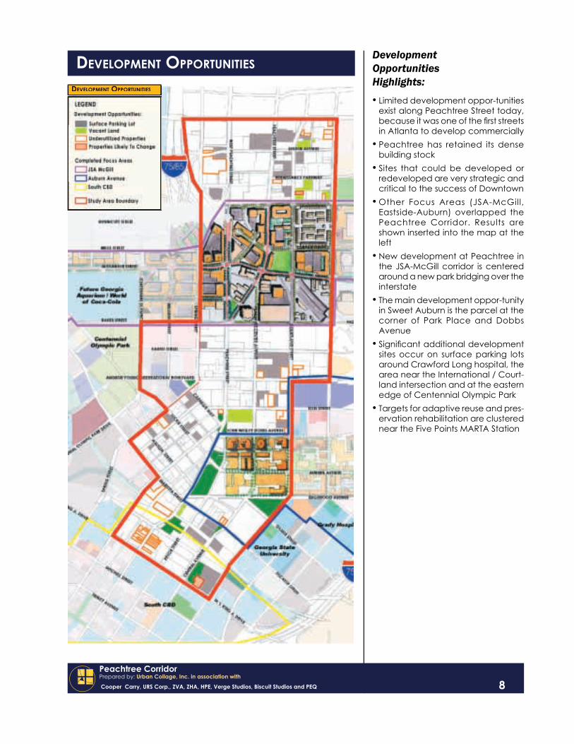
DEVELOPMENT OPPORTUNITIESDevelopment Opportunities Highlights:• Limited development oppor-tunities
exist along Peachtree Street today, because it was one of the fi rst streets in Atlanta to develop commercially
• Peachtree has retained its dense building stock
• Sites that could be developed or redeveloped are very strategic and critical to the success of Downtown
• Other Focus Areas (JSA-McGill, Eastside-Auburn) overlapped the Peachtree Corridor. Results are shown inserted into the map at the left
• New development at Peachtree in the JSA-McGill corridor is centered around a new park bridging over the interstate
• The main development oppor-tunity in Sweet Auburn is the parcel at the corner of Park Place and Dobbs Avenue
• Signifi cant additional development sites occur on surface parking lots around Crawford Long hospital, the area near the International / Court-land intersection and at the eastern edge of Centennial Olympic Park
• Targets for adaptive reuse and pres-ervation rehabilitation are clustered near the Five Points MARTA Station
DEVELOPMENT OPPORTUNITIES

Peachtree CorridorPrepared by: Urban Collage, Inc. in association with
Cooper Carry, URS Corp., ZVA, ZHA, HPE, Verge Studios, Biscuit Studios and PEQ
9
A signifi cant portion of the work done on the Peachtree Corridor involved public participation in three formats:• Core Team group discussions• One-on-one stakeholder interviews• Public Workshops (Charette Week)
Stakeholder Interviews
Approximately ten stakeholder interviews were conducted over the course of January and February 2004; this was in addition to the stakeholders interviewed as part of the processes for the JSA McGill and Auburn Avenue focus areas which overlap Peachtree. The interviews provided a forum for candid conversation between Core Team and community members and the Planning Team before the workshops were designed and planning concepts or alternatives proposed. The issues emerging from the interviews were anonyously gathered in a matrix (see Page 3) and presented to the Core Team during the second group forum. Subsequent discussions help form the framework for the Charette Week workshops.
Charette Week
The workshop for the general public was held over the course of three days between February 17 and February 19, 2004 at the 191 Peachtree Building. This ‘Charette Week’ was intended to provide the public with an opportunity for a focused, structured dialogue on key planning issues for the corridor including land use, circulation and urban design, followed by a team working session culminating in a third-day public presentation of the consensus plan. Both the initial session and the public recap were well-attended with around 100 persons at each.
Day one of the workshop opened with a welcome, introduction of the planning team and presentation of a short video orienting attendees to the existing conditions in the corridor and the strategic questions affecting the participatory exercises. The four-hour event was broken into three individual sessions – land use, circulation/open space, and identity. There were a total of ten tables with ten to twelve participants at each, guided by two facilitators at each table.
Session one, land use, began with groups identifying what they felt qualifi ed as a ‘Great Street’. The groups then outlined any districts in the corridor, colored in desired future land uses on a base map, and wrote down their retail preferences for several target buildings along Peachtree. Session two charged the groups with classifying each street according to the desired level of pedestrian activity, while thinking about locations for new open space, public enhancements and congregation points. Groups also had to select locations for parking and the route of a transit circulator if desired. Finally, groups were given two cross-sections of Peachtree and asked to use cut-out streetscape elements to design the street. Several consensus points emerged from the workshop:
• The Champs Elysees, Michigan Avenue and Fifth Avenue were the most popular ‘Great Streets’;
• Nine districts were identifi ed along Peachtree: SoNo, Centennial Hill, Civic Center, International Hotel & Shopping, Centennial Olympic Park, Fairlie-Poplar, Sweet Auburn, Underground, Georgia State, and Terminus;
• 180 Peachtree Building was identifi ed for entertainment retail, while a boutique hotel chosen for the Winecoff;
• A major architectural upgrade was advocated for the Five Points MARTA station;• A streetcar was supported along Peachtree; and• Wide sidewalks and new streescaping were priorities for the Peachtree cross-section.
COMMUNITY PARTICIPATION

Peachtree CorridorPrepared by: Urban Collage, Inc. in association with
Cooper Carry, URS Corp., ZVA, ZHA, HPE, Verge Studios, Biscuit Studios and PEQ
COMMUNITY PARTICIPATION
10
Community Participation Highlights:There was a wide array of opportuni-ties for public input for the Peachtree Corridor:• 30-member group of stakeholders
(A “Core Team”) met several times to provide specifi c input
• Numerous stakeholders were inter-viewed one-on-one
• Two public workshops - called ‘Cha-rette Week’ - were conducted over the course of three days
• Charette Week exercises were designed to engage the public on issues of future land use, circulation, open space and identity
• Recommendations from the first workshop were assimilated and presented back to the public for pri-oritization at the second workshop
• A final presentation to the Core Team provided comments on the framework plans and priority proj-ects
Peachtree Core Team members:

Peachtree CorridorPrepared by: Urban Collage, Inc. in association with
Cooper Carry, URS Corp., ZVA, ZHA, HPE, Verge Studios, Biscuit Studios and PEQ
In many ways, Peachtree Street embodies Atlanta’s “Front Porch” – a gracious welcome mat to the city’s visitors, a doorway into Downtown’s unique districts and a place to relax along the way. As such, the Peachtree Corridor Focus Area Plan identifi ed improvements associated with reinforcing the unique character of Peachtree and establishing gateways into the surrounding districts along its length. They are:
Underground District (District Spine: Alabama Street)This entertainment district to the east of Peachtree surrounds Underground Atlanta and anchors the southern end of Peachtree. The district includes shopping, restaurants and visitor destinations, with new residential units planned in the future.Terminus District (District Spine: Alabama Street)Along Alabama Street to the west of Peachtree lies the Terminus District, the existing home of the Nunn Federal Center and the central Five Points MARTA Station and the future location for the region’s Multimodal Terminal. This area forms its own Focus Area and was studied in detail separately.GSU District (District Spine: Decatur Street)Georgia State University has played an ever-increasing role in the vitality of Downtown, bringing students, faculty and visitors to its integrated urban campus. The heart of Georgia State University lies along Decatur Street to the east of Five Points.Farlie-Poplar District (District Spine: Luckie Street)To the west of Peachtree Street stretching towards the Georgia World Congress Center, CNN and Centennial Olympic Park lies the historic commercial heart of the City, the Fairlie-Poplar District, containing historic commercial high-rises, new and converted residential units and a concentration of diverse restaurants.Sweet Auburn District (District Spine: Auburn Avenue)Intersecting Peachtree at Auburn Avenue, the historic Auburn Avenue business district contains the birthplace of African-American business and entertainment within the City. This district was the subject of the Eastside/Auburn Focus Area, which identifi ed revitalization projects for smaller-scale mixed use development linking many of Atlanta’s major tourist destinations.International Hotel & Shopping District (District Spine: Andrew Young International Boulevard)This district includes the highest concentration of hotels in the city along with Peachtree Center and several of the city’s notable corporate landmarks. The district is centered along Andrew Young International Boulevard, which provides opportunities for new retail development as the major east-west connector through central Downtown.Centennial Hill District (District Spine: Simpson Street)This mixed-use, primarily residential district was the subject of the JSA-McGill Focus Area Plan, which established a vision of new infi ll development on the vacant lots and surface parking lots that dominate Centennial Hill. New retail activity is envisioned along Simpson Street leading into the new World of Coca-cola and Georgia Aquarium.Civic Center District (District Spine: Ralph McGill Boulevard)To the east of the Civic Center MARTA Station, this district contains the existing Atlanta Civic Center Complex and the opportunity for several new developments on the site and around the proposed Interstate Cap (expanded Mayor’s Park.)SoNo District (District Spine: Pine Street)At the northern end of Downtown, Peachtree Street bisects the South of North (SoNo) District, which includes high-rise offi ce buildings, Emory Crawford-Long Hospital, retail along Peachtree and an emerging new neighborhood to the east of Courtland Street.
DISTRICTS, SPINES & GATEWAYS
11

Peachtree CorridorPrepared by: Urban Collage, Inc. in association with
Cooper Carry, URS Corp., ZVA, ZHA, HPE, Verge Studios, Biscuit Studios and PEQ 12
DISTRICTS, SPINES & GATEWAYS Gateways To Downtown’s Districts:
Term
inus
Gat
eway
Geo
rgia
Sta
te U
nive
rsity
Gat
eway
Marietta Street Gateway
Underground Gateway
Sw
eet A
ubur
n G
atew
ayFa
irlie
-Pop
lar
Gat
eway
Inte
rnat
iona
l G
atew
ay C
ente
nnia
l Hill
Gat
eway
Civ
ic C
ente
r G
atew
ay S
oNo
Gat
eway

Peachtree CorridorPrepared by: Urban Collage, Inc. in association with
Cooper Carry, URS Corp., ZVA, ZHA, HPE, Verge Studios, Biscuit Studios and PEQ
The development framework plan is essentially two interwoven elements – a future land use plan and an open space plan - which order future development. Since much of the Peachtree Corridor is built out, there are limited opportunities for new open space, especially that which can act as a development catalyst. The major exception to this is the park that ‘caps’ the interstate at Peachtree and Ralph McGill. Construction of this park would provide a community focal point for the SoNo and Civic Center districts, and would help to stimulate development on the surface parking lots to the north and south and redevelopment of the historic Medical Arts Building. The park could ultimately be expanded down to Baker Street along the interstate, with the same catalytic effect. More discussion of this “Mayor’s Park” and the neighborhoods it supports can be found in the details of the JSA-McGill focus area.
SoNo, the area South of North Avenue, is one place where signifi cant development opportunities exist, but not without some public support. The neighborhood is affected by aggressive and intimidating behavior from individuals congregating in the vicinity of the Pine Street social service shelter, although it is unclear whether the individuals are coming to use the services or to prey on those who do. Renaissance Park, a wooded area on a slight hill north of the Civic Center, is host to homeless encampments and criminal activity. Between Renaissance Park and the shelter, Pine Street is generally avoided by pedestrians. Streetscape improvements and a conversion of one-way traffi c to two-way traffi c are recommended for Pine, with the stretch of Pine between Courtland and Piedmont seen as the neighborhood ‘center’ of SoNo. In keeping with the residential nature of the neighborhood, future development on the blocks north of Pine are recommended as high-density residential and residential mixed-use.
Andrew Young International Boulevard was positioned as the entry to Downtown and Centennial Olympic Park during the Olympic Games. Since then, International has remained the preferred pedestrian route between the hotel district and the Georgia World Congress Center, and has three signifi cant undeveloped or under-developed blocks along its length. Market potential for high-end retail and shops is greatest here, among the entire Peachtree Corridor. For these reasons, the development opportunities - two blocks at Centennial Olympic Park and the block north of International and west of Courtland - are proposed as high-density, classic urban mixed-use complexes similar to 900 North Michigan in Chicago or the Metreon in San Francisco. At International’s east end, a new gateway park is inscribed into three of the four blocks surrounding the Piedmont intersection.
Infi ll is the theme throughout Fairlie-Poplar, Auburn Avenue and Five Points. Surface parking in Fairlie-Poplar and along Wall Street at Underground are proposed as residential mixed-use, with the Wall Street parcels especially suitable for Georgia State student housing. Historic rehab of the mosaic of retail buildings along Peachtree at the Five Points MARTA station is also recommended. As part of the open space upgrades in this area, the Five Point MARTA station needs further study on improving its architectural presence and activating its barricaded plaza spaces. Likewise, the reuse and reprogramming of the existing World of Coca-Cola site should be considered as part of the development framework.
The development framework program for the Peachtree Corridor is illustrated on the following page.
DEVELOPMENT FRAMEWORK
13

Peachtree CorridorPrepared by: Urban Collage, Inc. in association with
Cooper Carry, URS Corp., ZVA, ZHA, HPE, Verge Studios, Biscuit Studios and PEQ 14
DEVELOPMENT FRAMEWORK The Development Framework PlanThe Peachtree Development Frame-work Plan describes potential future land uses on parcels that have been identifi ed as development opportuni-ties. Land uses aggregate into distinct ‘districts’ each having a unique iden-tity. They include:
9876
43
5Luckie-Auburn Streetcar
Mayor’s Park
International Circulator
MARTA Enhancements
Woodruff Park Enhancements
International Gateway Plaza
Land Use KeyRetailMercantileLodgingInstitutional / CulturalTransportation / UtilityParking Proposed Land Use
Low-Density ResidentialMedium-Density ResidentialHigh-Density ResidentialResidential / RetailResidential / Offi ce / RetailOffi ce / RetailOffi ce
The ‘SoNo’ District‘SoNo’, or the area South of NorthAvenue, is envisioned as a medium-density mixed-use residential neigh-borhood with an improved Pine Street as its gateway.
Centennial HillCentennial Hill is a mixed-use residen-tial neighborhood centering on Simp-son Street. Future land use includes offi ce, retail and hospitality, as well as residential.
International GatewayAs the major link between the hotels and Centennial Park, International Boulevard anchors this district of high-profi le retail and restaurants.
Five PointsThe historic heart of the city with a di-versity of land uses, centered around Underground Atlanta.
Priority ProjectsNine proposals to improve the public environment and encourage private development:
1 Peachtree Enhancements
2 Downtown Connectivity Study
Peachtree Streetcar

Peachtree CorridorPrepared by: Urban Collage, Inc. in association with
Cooper Carry, URS Corp., ZVA, ZHA, HPE, Verge Studios, Biscuit Studios and PEQ 15
The focus of the Peachtree Transportation Framework Plan is, not surprisingly, Peachtree Street. The Core Team and general public were very concerned that the pedestrian environment along Peachtree be grand and accommodating, and that the streetscape be distinguished from the rest of Downtown. Peachtree contains fi ve traffi c lanes from Baker Street to Forsyth Street, and drops down to four lanes north of Baker and South of Forsyth. Because the fi ve-lane portion corresponds to the hotel district with a need for better pedestrian amenities, the additional lane might be taken out and the width given over to each side. A new streetscape zone would be created in a six- to eight-foot band along each curb; the zone could contain landscape planters and street trees in addition to monumental lighting (see page 18, bottom). South of Forsyth, the generous existing pedestrian environment would be repaired and embellished if needed.
Mobility is also important on Peachtree. Although technically a separate initiative, the public wholeheartedly endorsed the idea of a streetcar running the length of the corridor. The two outer traffi c lanes would be shared with the streetcar rails, with vehicular left-turn movements free of the streetcar travel. Placing the trackage in the curb lanes allows the sidewalk to be used for queuing and stops, without additional right-of-way for pedestrian refuge islands. A second streetcar line is proposed for Luckie Street and Auburn Avenue running from the Martin Luther King National Historic Site or Studioplex to Centennial Olympic Park. The goal of both streetcar lines is to offer a highly visible and engaging way to connect Downtown attractions, one that allows many intermittent stops to boost retail potential.
Another proposed transit amenity is a shuttle or circulator - most likely a bus - that would run along International Boulevard and connect the Hotel District with the Centennial Olympic Park district. The circulator route could also use Baker Street as a means of accessing the Georgia Aquarium and World of Coca-Cola complex. Conventioneers and visitors are often discouraged from walking down International Boulevard because of the slope to Peachtree and the banal environment; the shuttle would alleviate some of this problem and would encourage new retail uses along the street.
Finally, there are several places where average traffi c volumes on one-way streets suggest the possibility of conversion (or return) to two-way traffi c. In some cases, like Luckie Street, International Boulevard and MLK Jr. Drive, two-way conversions would mean signifi cantly better east-west connections. In other cases, like Peachtree Center Avenue, two-way traffi c would help transition the street to a better urban avenue with a distinct identity. Further analysis in the form of a comprehensive downtown connectivity study is recommended for determining the feasibility of these one-way to two-way conversions.
Below is a matrix summarizing the recommended transportation improvements:
TRANSPORTATION FRAMEWORK

Peachtree CorridorPrepared by: Urban Collage, Inc. in association with
Cooper Carry, URS Corp., ZVA, ZHA, HPE, Verge Studios, Biscuit Studios and PEQ
Transportation Key
On-Street Parking
Streetcar Routes
Circulator Routes
Streetscape En-hancements
One-Way to Two-Way Street Conversions
On-Street Bike Lanes
Urban Bike / Pedestrian Path
TRANSPORTATION FRAMEWORK The Transportation Framework PlanThe Transportation Framework Plan identifi es key transportation enhance-ments such as on-street parking, two-way street conversions and transit routes, as well as ‘walkability’ enhancements like streetscapes and on-street parking locations. The main elements include:
Connectivity StudyGeneral study on improving Downtown connectivity through modifi cations in the street and sidewalk network
Peachtree Enhancement ProjectsRepair and maintenance of the Olym-pic streetscapes, as well as a new ceremonial streetscape from McGill to Margaret Mitchell Square utilizing an excess traffi c lane; on-street parking for off-peak hours from Baker to North Avenue; further study on the feasibility of a Downtown - Midtown streetcar.
International District Enhancement ProjectsIncludes a pilot circulator running along International Boulevard and connecting the Hotel District with the Georgia World Congress Center; new multi-use path on Baker Street from Freedom Park to Centennial Olympic Park; further study of two-way conversion of Baker, Harris and International.
Luckie-Auburn StreetcarFurther study on the feasibility of a streetcar connecting the King National Historic Site with Centennial Olympic Park, running along Auburn Avenue and Luckie Street.
One-Way to Two-Way ConversionsFurther study on reconfi guring several streets including COP Drive, MLK Jr. Drive, Peachtree Center Avenue and Pine Street to accommodate two-way traffi c.
16
Peachtree CorridorPrepared by: Urban Collage, Inc. in association with
Cooper Carry, URS Corp., ZVA, ZHA, HPE, Verge Studios, Biscuit Studios and PEQ 17
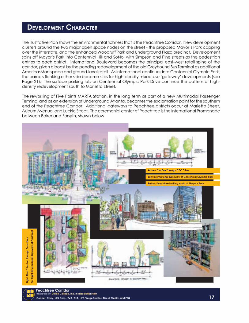
The Illustrative Plan shows the environmental richness that is the Peachtree Corridor. New development clusters around the two major open space nodes on the street - the proposed Mayor’s Park capping over the interstate, and the enhanced Woodruff Park and Underground Plaza precinct. Development spins off Mayor’s Park into Centennial Hill and SoNo, with Simpson and Pine streets as the pedestrian entries to each district. International Boulevard becomes the principal east-west retail spine of the corridor, given a boost by the pending redevelopment of the old Greyhound Bus Terminal as additional AmericasMart space and ground-level retail. As International continues into Centennial Olympic Park, the parcels fl anking either side become sites for high-density mixed-use ‘gateway’ developments (see Page 21). The surface parking lots on Centennial Olympic Park Drive continue the pattern of high-density redevelopment south to Marietta Street.
The reworking of Five Points MARTA Station, in the long term as part of a new Multimodal Passenger Terminal and as an extension of Underground Atlanta, becomes the exclamation point for the southern end of the Peachtree Corridor. Additional gateways to Peachtree districts occur at Marietta Street, Auburn Avenue, and Luckie Street. The ceremonial center of Peachtree is the International Promenade between Baker and Forsyth, shown below.
DEVELOPMENT CHARACTER
Above: Section Through COP Drive
Left: International Gateway at Centennial Olympic Park
Below: Peachtree looking south at Mayor’s Park
Righ
t: Pl
an /
Sec
tion
thro
ugh
Peac
htre
e
Far R
ight
: Int
erna
tiona
l Gat
eway
at P
iedm
ont

Peachtree CorridorPrepared by: Urban Collage, Inc. in association with
Cooper Carry, URS Corp., ZVA, ZHA, HPE, Verge Studios, Biscuit Studios and PEQ
DEVELOPMENT CHARACTER The Illustrative Plan
New buildings, and improved public space - are brought together in the Illustrative Plan to give an impression of how Downtown might look in the fu-ture with the improvements outlined in the Development and Transportation Framework Plans complete. Some of the highlights of the plan include:
Crawford Long CampusFuture expansions of the hospital com-plex frame the Peachtree and Linden intersection and add to the urban environment of SoNo
Mayor’s ParkA green refuge replacing the concrete canyon of the Interstate, Mayor’s Park provides a ceremonial entry to Down-town, the Hotel district and Centennial Hill. It bridges the divide between SoNo and the rest of Downtown, and provides for a pleasant passage to the Civic Center.
International BoulevardThe spine of a new retail and restau-rant corridor that relies on major de-velopment opportunities at either end, International Boulevard is an excellent candidate for offering a contrast-ing environment to the stateliness of Peachtree Street.
Auburn AvenueAuburn and Edgewood are at the core of a dynamic, historically-based neighborhood of diverse restaurants, entertainment venues, retail store-fronts and urban residences. The King Historic District unites all of Sweet Auburn under the common story of empowerment.
Underground AtlantaA unique urban experience at the very foundations of the city, Underground is a key piece in the pedestrian prom-enade between the State Capitol building and the future Multimodal Passenger Terminal.
18
Above: Illustrative Plan
Right: Peachtree Streetscape View