Embed Size (px)
Citation preview
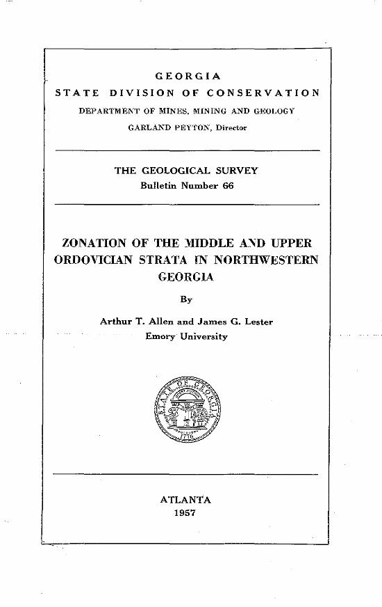
GEORGIA
STATE DIVISION OF CONSERVATION
DEPARTMENT OF MINES, MINING AND GEOLOGY
GARLAND PEYTON, Director
THE GEOLOGICAL SURVEY
Bulletin Number 66
ZONATION OF THE MIDDLE AND UPPER ORDOVICIAN STRATA IN NORTHWESTERN
GEORGIA
By
Arthur T. Allen and James G. Lester
Emory University
ATLANTA 1957
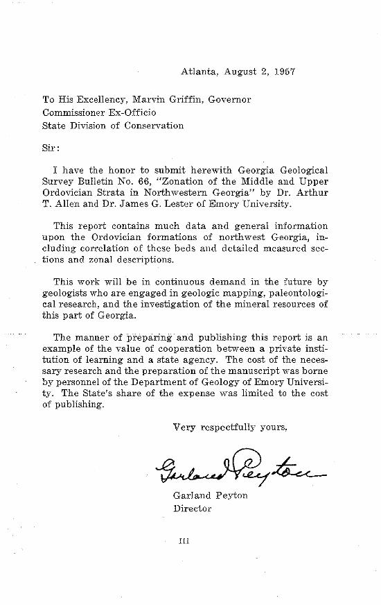
Atlanta, August 2, 1957
To His Excellency, Marvin Griffin, Governor Commissioner Ex-Officio State Division of Conservation
Sir:
I have the honor to submit herewith Georgia Geological Survey Bulletin No. 66, "Zonation of the Middle and Upper Ordovician Strata in Northwestern Georgia" by Dr. Arthur T. Allen and Dr. James G. Lester of Emory University.
This report contains much data and general information upon the Ordovician formations of northwest Georgia, including correlation of these beds and detailed measured sections and zonal descriptions.
This work will be in continuous demand in the future by geologists who are engaged in geologic mapping, paleontological research, and the investigation of the mineral resources of this part of Georgia.
The manner of preparing and publishing this report is an example of the value of cooperation between a private institution of learning and a state agency. The cost of the necessary research and the preparation of the manuscript was borne by personnel of the Department of Geology of Emory University. The State's share of the expense was limited to the cost of publishing.
Very respectfully yours,
Garland Peyton Director
Ill
TABLE OF CONTENTS Page
Abstract _____ -------------- --------------- ------------------- -------------- --------------- --------------
Introduction --------------- -------------- -------------------Location of Area ---------------- ---------------General Geology of the Area ______ -------------------------------- ------------------------------Previous work ------------------------------ --------------- ---------------- --------------------------Acknowledgments ---------------- ----------------------------------- ------------------------Method of Zonation ----------- ---------------- ---------------- --------------------------- ----------------Description of Measured Sections _________________ ----------------------------------------------
Near-Shore Facies ---------------------- -----------------------------------------------------------------Introduction ----------------------------- ---------------------------------- --------------Mill Creek Strike Belt Sections __________________ , _______ ---------------
1. New Hope Church ____ --------------------- ---------------2. Hamilton Mountain _ ----------------- -------------------------- -------------- ---------------
1
2 2 4 4 5 5 6
8 8 8 8 8
3. Rocky Face ----------------------------- ------------------------------ --------------·-------------- 10 4. Mill Creek ........................... ·······-························ ............................ 10 5. Dug Gap ·························-·· .................................. ................................... 11
Master's Pasture ----------- ---------------------------------- -------------------------6. Furnace Creek ---------- --------------------------------- --------------------------- --------------7. 8.
Horn Mountain _ Johns Mountain
12 12 13 13
General Description of Near-Shore Zones -------- ----------------------------------- 16 Zone +5 ......................................................................................................... 16 Zone +4 _________ --------------------------------------- -------------------- ------------·----- 16 Zone +3 ............................. ................. .................................................. 17 Zone + 2 -------------- ------------------------ -------------------- ------------------------------------ 17 Zone +1 .... . ............................................................................................... 18 Zone 0 --------------·-- -----------------------·- -----------------·--------------------- -------------------------- 19 Zone -1 -----------------------------·-- ------------------------- ------------------- ------------------------------Zone -2 ------------------------- ---------------------------------------- ------------------------Zone -3 ___________ ------------------------------------------------------ -------------------- -----------------Zone -4 ____ ------------------------ ---------------------- ---------------------------------------·-··--Zone -5 ------------------------------- ----------------------- --------------------------------------------
Offshore Facies ---------------------- --------------------- -----------------------------------
20 22 23 24 25
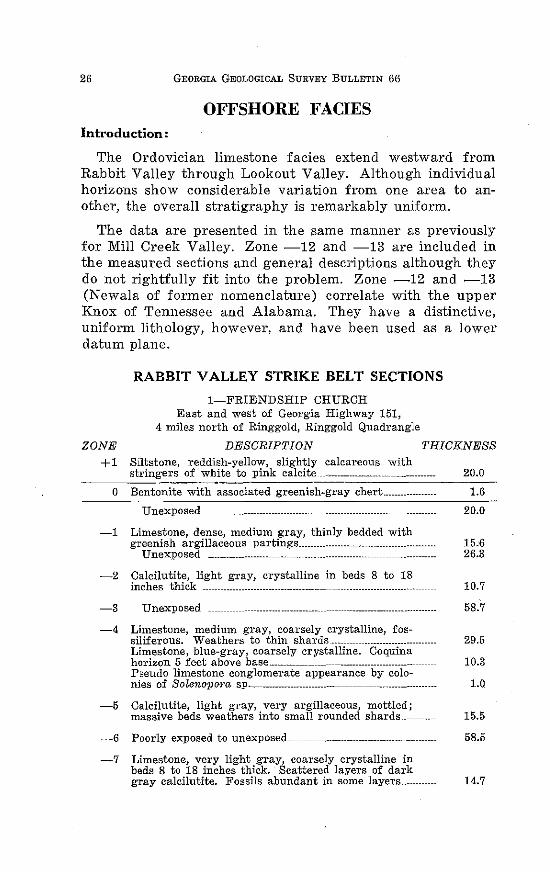
Introduction --------------------- ------------------- -------------------------- ------------------------- 26 Rabbit Valley Strike Belt Sections
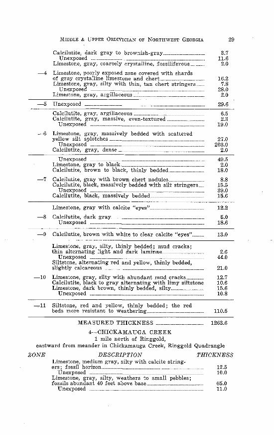
1. Friendship Church -------- ---------------------------- -------------------- ----------------- 26 2. Pleasant Valley ~----- -------------------------- ----------------------------- --------------------- 27 3. Benchmark 120 --------------------- ---------------------------- --------------------------· 28 4. Chickamauga Creek ----------- _ -------------------------- ----------------------- 29 5. Maddox Gap ........... ....... .. ....................................................... 30 6. Smith Gap .............................. ......................... 31
Chickamauga Valley Strike Belt Sections 1. Bethel Church ................ ............................ .................................. 34 2. Telephone Line _____ _ 34
IV
Page
3. Pigeon Mountain ---·-----·---···-·--··--------- ~ ~~~~~~~~"~~~~~~~ ~~~~~ 35 4. T. A. G. Railroad ------------------··---·--··--·------ 36 5. Voiles Creek ______ -----------------------------------·---------------··-·-·--·-----------·--··--·-··--- 37 6. Hog Jowl Creek ___ .. ·------------·--··--··-··---·······-····--·-··· 38
Chattanooga Valley Strike Belt Sections 1. Mill Branch ------------------··--··--·--··--·--··--·--2. Cooper Heights Quarry ----------··----------
~~~~~~~~~ ~~~~~~~~~~~~~~~~~ ~~~~~~~~~~~~ 40 ~ ~~~~~~~~ ~~~~ ~~~ ~ ~~~ ~ ~~ ~~ ~~ ~ ~ ~~ ~ ~~ ~ ~~~ ~ 41
3. Cooper Heights No. 2 ----------------·--·--··-·· _____________ _ 41 Lookout Valley Strike Belt Sections
1. Morganville --------- ---------------------------------·--------··-- ·--------------··-------·-··--------- 44 2. Trenton --·----------------------- ------------------------------ ~~~~~~~~~~~ ~~~~~~~~~~~~~ 44 3. Union ------------------------·--·---------- _____________ _ 44 4~ U. S. Highway 11 ~~~~~~~~~~~~~~~~~~ 45
General Description of Offshore Zones -------·····-····--··---·--··-----------·····-···-···-··--·- 47 + 8 ~~~~~~~~~~~~~~~~ ~~~~~~~~~~~~~~~~~~~~~~~~~~~~~~~~~~~ ~~~~~~~~~~~~~~~~~"~~~~~~ 4 7
+ 7 ·--------------····· ----------------------------------- --------------------------------------------------------------- 48 + 6 ~~~~~~~~~~~~~~~~~~~~~~~~ ~~~~~~~~~~~~~~~~~~~~~~~~~~~~~~~~~~~~~~~~~~~~~~~ 50 + 5 ~~~ ~~~~~~~~~~~~~~~~~~~~~~~~ ~~~~~~~~~~~~~~~~~~~~~~~~~~~~~~~~~~~~~~~~~~~~~~~~~~~~~~~~~ 52 + 4 ~~ ~~~~ ~ ~~ ~ ~ ~ ~ ~~~~~ ~ ~~ ~~~~ ~~~ ~~~ ~~~~~- ~~~~ ~~~~ ~~~ ~~~-~~ ~~~~ ~~ ~~ ~~~~~~ ~~ ~~ ~~~~~~ ~~~~~~~~ ~~~~~~~~ ~~~ ~ ~~~ ~~~~ ~~~ ~ ~~~ ~~~ ~ 5 3 + 3 ~~ ~~~~ ~~~ ~ ~ ~~~ ~~~ ~~~~~~~~ ~~ ~~~~~~ ~~~~~~ ~~~ ~ ~ ~~ ~~~~~~ ~~~~ ~~~~~~~~~~~~~~ ~~~~~~ ~~~~~~~~~~~ ~~~ ~ ~~~ ~~~~~ ~~~ ~ ~~ ~ ~~~ ~ ~ ~~ ~ ~~~ ~ 5 5 + 2 ---------------------- -------------------------·-------- ------------------------------------- -·--------·-------·---- 58 + 1 ~~~~~~ ~~~~~~~-~~~~~~~~~~ ~~~~~~~~~~~-~~~~~~~~~~~~~~~~~~~~~~~~~~~~~~~~ ~~~~~~~~~~~~~~~-~~~ 6 0
0 ~~~~~~~~~~~~ ~~~~~~~~~~~-~~~~~~~~~~ ~~~~~~~~~~~~~~~~~~~~~~~~~~~~~~~~~~~~~~~ 6 3 -1 ~~~~~~~~~~~~~~- ~~~~~~~~~~~~~~~~~~~~~~~~ ~~~~~~~~~~~~~~~~~~~~~~~~~~~~~~~~~~~~~~~~~~-~~~~~~~~~~~~~ 6 7 -2 ~~~~ ~~~ ~~~ ~~ ~~ ~~~~~ ~~~ ~ ~~~~~~~~~~~ ~ ~~ ~~~ ~~ ~ ~~~ ~~~~ ~~~ ~~~~~~~ ~~~ ~ ~~~~~ ~ ~ ~ ~~ ~~ ~ ~~ ~ ~ ~~~ ~~~ ~ ~~~~ ~~~~ ~~~ ~ ~~ ~ 71 -3 ~ ~~~ ~ ~~~ ~~~~~~-~~~~~~~~~ ~~~~~~~~~~ ~~~~~ ~~~~ ~~ ~ ~ ~~~~ ~~~~~~~~ ~ ~~~ ~~~~ ~~~ ~~~~~~~~~ ~~~ ~~~~ ~~~~~~~ ~ ~~~~~~-~~ 7 5 -4 ~~ ~~~~~~~~~~~-~~~~~~~~~~~~~~ ~~~~-~~~~~~~~~~~~~~~~~ ~~~~~~~~~~~~~~~~~~~~~~~~~~~~~~~~~~~~~~~~~ 7 7 -5 ~~~~~~~~~~~~~~-~~~~~~~~~~~~~~~~~ ~~~~~~~~~~~~~~~~~~~~~~~~~~~ ~~~~~~~~~~~~~~~~~~~~~~~~~~~~~~~~~~~ ~~~~~~~ 8 0 - 6 ~ ~~ ~ ~ ~~~ ~~~~~~- ~~ ~~ ~~~ ~ ~~~~~ ~~~ ~~ ~ ~~~~ ~~~ ~ ~~~ ~~~ ~ ~~~~~~~~ ~ ~~~~ ~~~ ~~~ ~~ ~~~ ~~~~~~~~ ~~ ~ ~~~~ ~~~~~ ~~ ~ ~~~ " ~ ~~ ~ ~~~ ~~~ ~ ~~ 8 2 -7 ~~~~~~~~~~~~~~-~~ ~~~~~~~~~~~~~~~~~~~~~~ ~~~~~~~~~~~~~~~~~~~~~~~~~~~~ ~~~~~~~~~~~~~~~~~~~~~~~~~~~~~~~~~~~~~~~~~~~~~ 84 -8 ~~ ~~~~~~~~~~~-~~~~~~~~~ ~~~~~~~~~~~-~~~~~~~ ~~~~~~~~~~~~~~~~~~~~~~~~~~~~ ~~~~~~~~~~~~~~~~~~~~~~~~~~~~~~~~~~~~~~~~~~~~ 88 -9 ~~~~ ~~~ ~~ ~~~~- ~~~~~~~ ~~~~~~-~~~~~~~~~~~~~~~ ~~ ~~~ ~~~~~~~~~~- ~~~~~~~~ ~~~~~ ~~~~~~~~~~~~ ~~~-~~~~~~~ ~~~~~~~ ~ ~~~ ~~~ ~ ~~ ~ 8 9
-1 0 ~~~~~~~~~~~~~~-~~~~~~~~~~~~~~ ~~~~~~~~~~~~~~~~~~~~~~~~ ~~~~~~~~~~~~~~~~~~~~~~~~~ ~~~~~~~~~~~~~~~~~~~~~~~~~~~~~~~~~~~~~~ 91 -11 ~~~~~~~~~~~~~~~~~~~~~ ~~~~~~~~~~~~~~~ ~~~~~~~~~~~~~~~~~~~~~~~ ~~~~~~~~~~~~~~~~~~~~~~~~~~~~ ~~~~~~~~~~~~~~~~~~~~~ 9 3 -12 ~~~ ~~~~~~~~~~-~~~~~~~~ ~~~~~~~~~~~~~~~~~ ~~~~~~~~~~~~~~~~~~~~~~-~~~ ~~-~~~~~~~~~~~~~~~~~~~~ ~~~~~~~~~-~~~~~~~ ~
-13 ---·--·---. -------------------------------------------------------- -----------------------------96 97
Conclusions ~~~~~~~~~~~~~~~~~~~ ~~~~~~~~~~~~~~~~~ ~~~~~~~~~~~~~~~~~~~~~~~~~ ~~~~~~~~~~~~~~~~~~~~~~~~~~~~~~~~~~ 10 1
v
TABLE OF PLATES
PLATE
1. Index Map of Area Showing Location of Sections __ ---------------
2. Mill Creek Strike Belt Sections ____ -----------------
3. Rabbit Valley Strike Belt Sections
Page
3
15
~~~-------- 33
4. Chickamauga Valley Strike Belt Sections ____ _ ~~--~~----~----- ---~~---- 39
5. Chattanooga Valley Strike Belt Sections ____ --------------------
6. Lookout Valley Strike Belt SectiOns ---------------- -"------------ -----------------
7. Correlation of Generalized Strike Belt Sections -------------
43
46
____ 105
8. Stratig-raphic Relations of Ordovician Strata ___ ----------------- ___ 106
9. Zonal Distributio~ of Fossils (in pocket) ---------------- __ _in pocket
VI
TABLE OF PHOTOGRAPHS
FIGURE Page
1. Bentonite overlying massive quartzite in roadcut of U. S. Highway 41 at Hassler's Mill ---------------------- ------------------------- 20
2. Jointing in siltstone of ~1 Zone in roadcut of U. S. Highway 41 west of Hassler's Mill ------------------------------------------------------------------ _______ 21
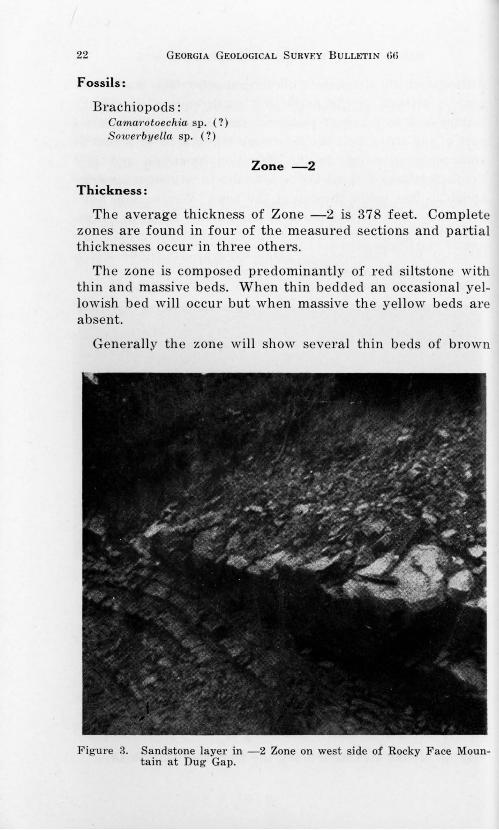
3. Sandstone layer in -2 Zone on west side of Rocky Face Mountan at Dug Gap ----------------- _____ ----------------------------------- 22
4. Red argillaceous calcilutite in Master's Pasture, west of Dug Gap Road ------------------------------ _ ----------------------------------------------------- ___________ 25
5. Invertebrate tracks in green chert layer in Rabbit Valley_ 64
6. Bentonite horizon in McFarland Gap Quarry, Chickamauga Valley ------------------- -------------------- ------------------------------------------------------------------ 65
7. Hesperorthis and Sowerbyella coquina in Chickamauga Valley__ 72
8. Folding in limestone in Work Farm Quarry ---------------------------- 75
9. Thinly bedded limestone in Rabbit Valley ----------------------------------------- 78
10. Red and yellow calcareous siltstones along Georgia Highway 151 in Rabbit Valley ---------- ------------------------------------------------------------------- 85
11. Black chert "ropes" west of Georgia Highway 151 at Friend-ship Church ----------- ___________ -------------------------------------- 90
12. Mud cracks in Rabbit Valley 94
VII

ZONATION OF THE MIDDLE AND UPPER
ORDOVICIAN STRATA IN NORTHWEST
GEORGIA
Arthur T. Allen and James G. Lester
ABSTRACT
Five belts of Ordovician strata have been mapped and measured. The Mill Creek Belt is the Near-Shore Facies and Rabbit Valley, Chickamauga Valley, Chattanooga Valley, and Lookout Valley Strike Belts comprise the Offshore Facies.
A layer of bentonite occurring just above the contact between the middle and upper Ordovician strata is easily recognizable in all strike belts. The horizon has been designated as the 0 Zone and all beds above and below have been divided into distinct lithologic and paleontologic units and assigned plus or minus zone numbers. Five plus zones and five minus zones are separated in the Near-Shore Facies and eight plus zones and thirteen minus zones are separated in the Offshore Facies.
Detailed measured sections and generalized zonal descriptions are presented as evidence for the stratigraphic and depositional conclusions. The zonal distribution of fossils is included in chart form in pocket.
1
INTRODUCTION
The present investigation is an outgrowth of dissatisfaction with our inability to correlate beds of known Ordovician strata with previously defined formations. Shortly after establishing the Emory Geology Camp near Ringgold in 1948, this difficulty became apparent. As a result a detailed study of Ordovician strata was begun in the summer of 1950 and has been continued during the field seasons up to the present time.
The authors have carefully collected data from all the available exposures and have measured more than 50 detailed stratigraphic sequences. Many students have worked on and contributed greatly to this study. Special credit should be given to C. Wright, L. Vest, R. Murphy, T. Ingram, J. B. Moore, and L. Buzarde who have worked on individual areas and have presented theses related to this general topic.
Location of Area
The Ordovician strata (Plate 1) studied occur in Whitfield, Chattooga, Catoosa, Walker, Gordon, and Dade Counties. The outcrop pattern occupies approximately 145 square miles of the 1025 square miles of the area of these counties.
Outcrops are scattered in all of the strike belts but are poorer and represent only a restricted part of the sequence in the easternmost belt in Murray County, in the small belt to the west of Georgia Highway 71, and in the southern portion of the strike belts. For this reason the northern portion of the five westernmost belts were selected for detailed investigation. More specifically the area is bounded by longitude 85°00' on the east, 85°37'30" on the west; latitude 35°00' on the north, and 34°37'30" on the south.
Fortunately, the area has almost complete map coverage by the Tennessee Valley Authority Seven and One-Half Minute Quadrangle Series. The following quadrangle maps were used: Ringgold, Ga.-Tenn.; Tunnel Hill, Ga.; Villanow, Ga.; East Ridge, Ga.-Tenn.; Nickajack Gap, Ga.; Catlett, Ga.; Fort Oglethorpe, Ga.-Tenn.; Kensington, Ga.; Hooker, Ga.Tenn.; Durham, Ga.; Cedar Grove, Ga.; Shell Mound, Ga.Ala.-Tenn.; Trenton, Ga.-Ala.; and Sulphur Springs, Ala.-Ga. Catoosa and Dalton Quadrangles of the United States Geologi-
2
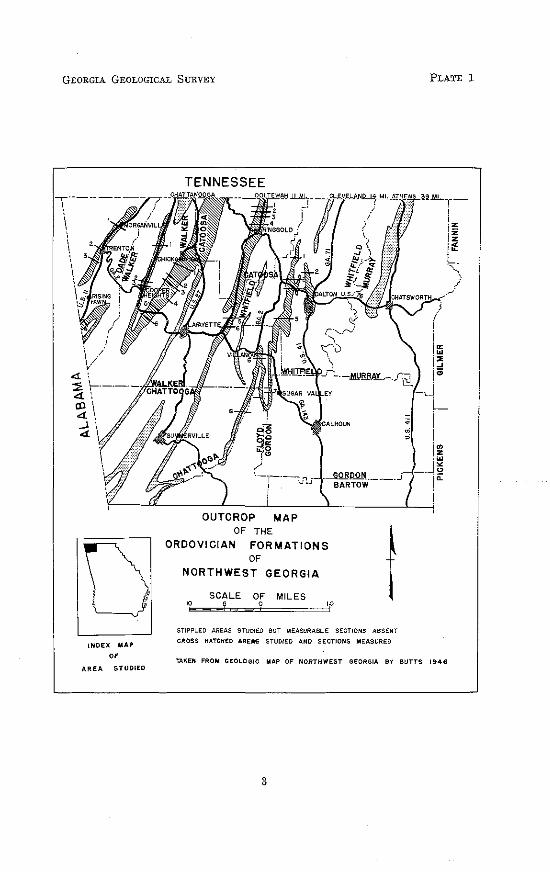
GEORGIA GEOLOGICAL SURVEY PLATE 1
D INDEX MAP
" AREA STUDIED
TENNESSEE
OUTCROP MAP OF THE
ORDOVICIAN FORMATIONS OF
NORTHWEST GEORGIA
SCALE OF MILES 0
t STIPPLED AREAS STUDIED BUT MEASURABLE SECTIONS ABSENT
CROSS HATCHED ARE..S STUDIED AND SECTIONS MEASURED
TAKEN FROM GEOLOGIC MAP OF NORTHWEST GEORGIA BY BUTTS 1946
3
4 GEORGIA GEOLOGICAL SURVEY BULLETIN 66
cal Survey Fifteen Minute Series were used for those areas not covered by the Tennessee Valley Authority Maps.
General Geology of the Area
Within the area all rocks are of Paleozoic age and formations representing all periods from Cambrian to Pennsylvanian, with Devonian st:r:ata restricted, are exposed. Twenty-six formations with an aggregate thickness of 11,500 feet more or less are present.
Physiographically the area is classed as Valley and Ridge except for the presence of a small part of the Cumberland Plateau in the extreme northwest corner. The larger and highest mountains, Lookout and Little Sand, are capped with lower Pennsylvanian strata; the secondary ridges are monoclinal and capped by the Silurian Red Mountain Formation. Third order ridges are composed of Knox residuum. The Knox Formation forms the lower limit and the Red Mountain Formation, the upper limit of the strata included in this study, all of which crop out in the valleys and on the scarp slopes of the monoclinal ridges. Structurally it is a region· of northeast trending synclinal mountains and anticlinal valleys.
High. angle overthrust faults, both simple and bifurcating are common and trend in directions essentially paralleling the
. ridges and valleys. No attempt is made to present the structural detail of the area and the study has been restricted to the sedimentary and the stratigraphic relations.
Previous Work
The pioneer worker on the Paleozoic rocks of Georgia was C. W. Hayes of the United States Geological Survey. The Ordovician rocks were first described in the Rome Folio by Hayes (1902) in which he named the thick sequence of limestones between the Knox Formation and the Red Mountain Formation the Chickamauga limestones. At that time, however, the Ordovician· period was not recognized and the Chickamauga was included as part of the Silurian system.
Since 1894 nineteen papers have been published on the Paleozoic area in Georgia, twelve of these appearing since 1900. Five of these have dealt almost exclusively with eco-
MIDDLE & UPPER 0RDIVICIAN OF NORTHWEST GEORGIA 5
nomic aspects and only three have dealt specifically with any Ordovician strata.
Butts (1948) dealt with the regional aspects of the Paleozoic rocks of northwest Georgia. Munyan (1951) briefly discussed the eastern facies of Ordovician strata occurring in the Dalton Quadrangle and Allen and Lester (1954) figured some Ordovician fossils.
Butts (1926, 1940, 1948) in his work in Alabama, Virginia, and Georgia attempted to bring the nomenclature of Ordovician strata into harmony with that of Ulrich (1911) and others. Ulrich and Schuchert (1902) suggested that east-west variation in the stratigraphic sequence resulted from parallel barriers separating the Appalachian Geosyncline into separate troughs. Ulrich (1911) recognized the presence and absence of lithologic units in parallel strike belts but continued to attribute this to different troughs of deposition. Raymond (1920) suggested that this condition might result from differences in depth of water and distance from shore.
Undoubtedly much of the difficulty in correlation of the Ordovician strata has resulted from Butts' acceptance of Ulrich's hypotheses rather than that of Raymond. Cooper and Prouty (1940) challenged earlier work in Tennessee and Virginia and proposed a new system of classification.
Many significant papers on Ordovician problems in other areas have appeared during recent years and a selected list of these is included in the references.
Acknowledgments
We wish to express our appreciation to the Emory University Research Committee for making funds available for field transportation. Also, to thank Capt. Garland Peyton and Dr. A. S. Furcron of the Georgia Division of Mines, Mining, and Geology for editorial assistance.
Method of Zonation
The Ordovician strata represents two distinct lithologic types and depositional environments. The eastern sediments are designated as the Near-Shore Facies and the remaining as the Offshore Facies.
6 GEORGIA GEOLOGICAL SURVEY BULLETIN 66
The Near-Shore sediments have a thickness of 2300 feet and have been separated into eleven zones. All the areas of outcrop lying east of Taylor-White Oak Ridge fall into this classification.
The Offshore Facies comprise the rocks of the northern part of Rabbit Valley, Chickamauga Valley, Chattanooga Valley, and Lookout Valley. The thickness varies from 1400 to 2100 feet (including -12 and -13 Zone) and the strata are divisible into twenty-two units.
Occurring near the base of the upper Ordovician sequence in the Offshore Facies is a prominent bentonite layer which varies in thickness from a few inches to several feet and is underlain by green chert in those areas where limestone once occupied this position and subsequently became silicified. It is underlain by quartzite in the Near-Shore Facies. Since this marker is persistent and easily recognizable and since the ash fall from which it resulted seems to be time equivalent, it has been nsed as the primary datnm plane. It is referred to in the following discussion as the zero bed and all units above it are assigned plus numbers and all units below it have. been assigned minus numbers.
Although all zones have been given numbers in order to' separate them from overlying and underlying strata, all the zones are not equally distinctive. Some are more distinctive because of their position between easily recognizable faunal and lithologic units than for their own lithologic and faunal characteristics. Many of the zones have been delimited on fossil evidence and others on lithology.
Description of Measured Sections
For uniformity all measured sections are presented from north to south in each strike belt and the strike belts are discussed from east to west. The location of any section in any strike belt may be determined from the index map of the entire area or from the index map on each strike belt section.
All strike belts of mappable units occur in valleys. The names used for the sections are the local valley names. The Mill Creek Strike Belt, because it is the easternmost one includes a section, No. 2, Hamilton Mountain, which actually is a short distance east of the area. The belts selected for this
MIDDLE & UPPER 0RDIVICIAN OF NORTHWEST GEORGIA 7
work have been designated, from east to west, Mill Creek Valley, Rabbit Valley, Chickamauga Valley, Chattanooga Valley, and Lookout Valley.
Correlations along the strike belt are not easy and from one strike belt to another the difficulty increases. Correlations are troublesome because of the number of incomplete sections brought about by the effects of topography, weathering, structure, and human culture.

8 GEORGIA GEOLOGICAL SURVEY BULLETIN 66
NEAR-SHORE FACIES Introduction:
In the discussion of the two major subdivisions, the detailed sections are followed by a general description of each zone. Since few, if any of the sections, are complete this is the only manner in which the data could be presented in an understandable form.
The strata in this strike belt are composed essentially of siltstones and sandstones which have been involved in intense folding.
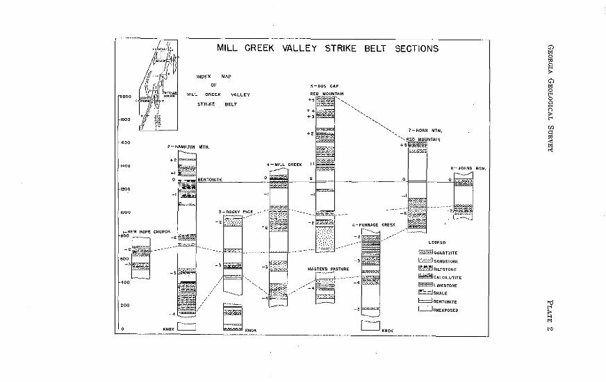
MILL CREEK STRIKE BELT SECTIONS
1-NEW HOPE CHURCH 10 miles northeast of Tunnel Hill on Varnell Road,
1000 feet east of New Hope Church, Tunnel Hill Quadrangle
ZONE DESCRIPTION THICKNESS Sandstone, red, fine-grained, well-indurated in 8 to 12 inch layers. Interbedded thin; red siltstone________________ 8.0
- 2 Sandstone, red, fine-grained, well-indurated in 4 to 6 inch layers interbedded with massive dark maroon siltstone, some of which shows green mottled areas_____ 28.5
Siltstone, dark maroon, massively bedded. G1een mottled irreg~1lar areas present____________________ --------------- 44.5
U nexpos~d -------------------------------------------------------------------------- 57.5 Siltstone, yellow, thinly laminated, alternating with
- 3 thin layers of red fissile shale-------------------------------------------- 20.0
ZONE
Siltstone, red, fissile, thinly laminated------------------------------- 41.0 Siltstone, purplish maroon, calcareous with scatter-ed irregularly shaped and sized areas of buff color___ 9.0 Siltstone, yellow, thinly bedded, non-calcareous -------------- 3.0
MEASURED THICKNESS ··········- ----·-··········-- 211.5
2-HAMILTON MOUNTAIN East-west road from Georgia Highway 71
five miles north of Dalton, Dalton Quadrangle
DESCRIPTION Sandstone, red, fine-grained, indurated; beds vary in thickness from 2 to 8 inches in upper part. Some
THICKNESS
slickensides and jointing developed ________________ --------------------· 9.0
+ 2 Unexposed interval, soil indicates derivation from sandstone ------------------ ------------------------------------------ -------------------- 42.0 Sandstone, fine-grained, red to purplish, indurated. Thin layers of interbedded siltstone·····--·--------------------- 23.0
Siltstone and shale, reddish to purple, mottled with occasional yellowish spots; thinly laminated. A fine-grained, buff sandstone 16 feet above the base _________ 60.0
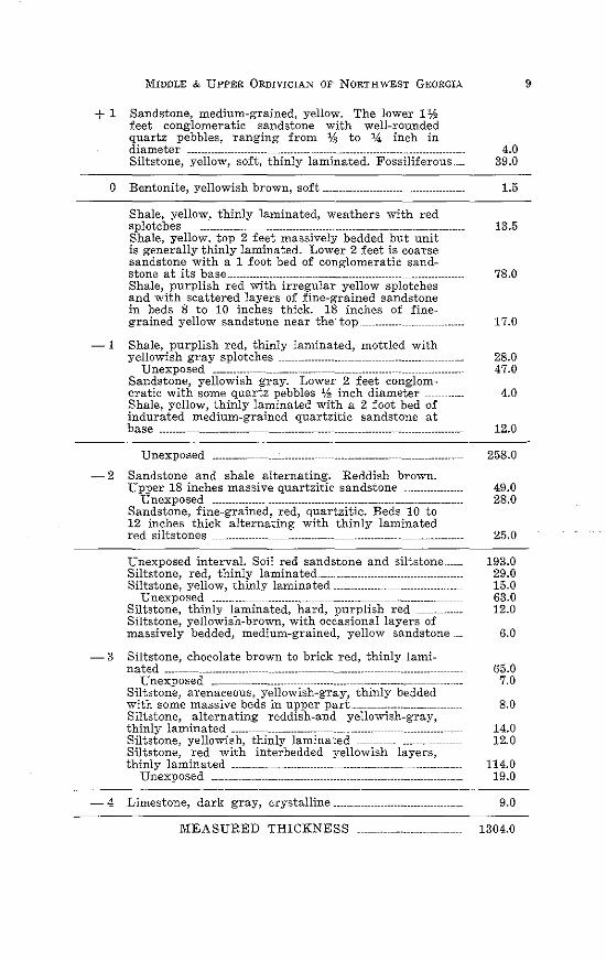
MIDDLE & UPPER 0RDIVICIAN OF NORTHWEST GEORGIA.
+ 1 Sandstone, medium-grained, yellow. The lower 1% feet conglomeratic sandstone with well-rounded quartz pebbles, ranging from Vs to % inch in
0
diameter _ ---------------··--- --------------------- 4.0 Siltstone, yellow, soft, thinly laminated. Fossiliferous ___ 39.0
Bentonite, yellowish brown, soft --------------- _______________ , 1.5
Shale, yellow, thinly laminated, weathers with red splotches ----------------- ------------------------- ------------------------ 13.5 Shale, yellow, top 2 feet massively bedded but unit is generally thinly lamina:ed. Lower 2 feet is coarse sandstone with a 1 foot bed of conglomeratic sand-stone at its base------------------------------------------- ____ _ ______________ 78.0 Shale, purplish red with irregular yellow splotches and with scattered layers of fine-grained sandstone in beds 8 to 10 inches thick. 18 inches of fine-grained yellow sandstone near the· top ___ _______________ 17.0
-1 Shale, purplish red, thinly laminated, mottled with yellowish gray splotches ------------------- ----------------------- 28.0
Unexposed ________________________ .. _______ _ ------------- --------------------- 47.0 Sandstone, yellowish gray. Lower 2 feet conglom-eratic with some quartz pebbles % inch diameter 4.0 Shale, yellow, thinly laminated with a 2 foot bed of indurated medium-grained quartzitic sandstone at base ________ ------------------ ------------------------ ------------------ __________________ 12.0
Unexposed 258.0
-2 Sandstone and shale alternating. Reddish brown. Upper 18 inches massive quartzitic sandstone ____________ 49.0
Unexposed ________________ ------------------------------------------ ________________ 28.0 Sandstone, fine-grained, red, quartzitic. Beds 10 to 12 inches thick alternating with thinly laminated red siltstones ______________ --------------------- 25.0
Unexposed intervaL Soil red sandstone and siltstone ____ __ Siltstone, red, thinly laminated ---------------------Siltstone, yellow, thinly laminated--------------------------------------
Unexposed __________ ------------------ _______________ ------------------------Siltstone, thinly laminated, hard, purplish red ____________ __ Siltstone, yellowish-brown, with occasional layers of massively bedded, medium-grained, yellow sandstone ___
193.0 29.0 15.0 63.0 12.0
6.0
-3 Siltstone, chocolate brown to brick red, thinly lami-
-4
nated ____ -------------------- -------------- --- --------------- ---------------------Unexposed __ ------------------- ------------------ ----------------- ______________ __
Siltstone, arenaceous, yellowish-gray, thinly bedded with some massive beds in upper part..-----------------------Siltstone, alternating reddish-and yellowish-gray, thinly laminated ______ ------------------- _______________ ----------------------Siltstone, yellowish, thinly laminated Siltstone, red with interbedded yellowish layers, thinly laminated ----------------- --------------------------
Unexposed ____ ----------------- -----------------·· ---------------------
Limestone, dark gray, crystalline. _____ ----------------------
MEASURED THICKNESS
65.0 7.0
8.0
14.0 12.0
114.0 19.0
9.0
1304.0
9
10 GEORGIA GEOLOGICAL SURVEY BULLETIN 66
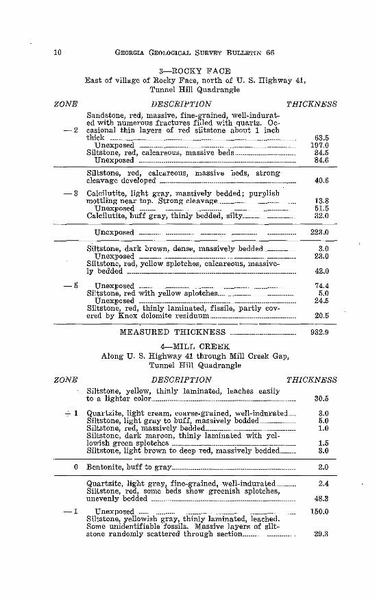
3-ROCKY FACE East of village of Rocky Face, north of U. S. Highway 41,
Tunnel Hill Quadrangle
ZONE DESCRIPTION THICKNESS Sandstone, red, massive, fine-grained, well-indurated with numerous fractures filled with quartz. Oc
- 2 casional thin layers of red siltstone about 1 inch thick ---------------- ---------------- ---------------- ---------------
Unexposed ------------------------- -------------------------- -----------------Siltstone, red, calcareous, massive beds ----------------------------
Unexposed _ --------------------------------- -----------------
Siltstone, red, calcareous, massive beds, strong cleavage developed ----------------------- ---------------
63.5 197.0 34.5 84.6
40.6
-3 Calcilutite, light gray, massively bedded; purplish mottling near top. Strong cleavage _____________ --------------- 13.8
Unexposed ___________ ---------------- -------------------- 51.5 Calcilutite, buff gray, thinly bedded, silty ___________ -------------- 32.0
Unexposed ------------ --------------- 223.0
Siltstone, dark brown, dense, massively bedded______________ 3.0 Unexposed -------------------------------------------- ---------------------------- 23.0
Siltstone, red, yellow splotches, calcareous, massive-ly bedded ·········-----·········· ------··········----··········-- ------··········- 42.0
-5 Unexposed --------------------------------------------------------------- 74.4
ZONE
Siltstone, red with yellow splotches ________________ -------------------- 5.0 Unexposed -------------------------------------------------------------------------- 24.5
Siltstone, red, thinly laminated, fissile, partly cov-ered by Knox dolomite residuum____ ---------------------- 20.5
MEASURED THICKNESS ·-·- ----···········-
4-MILL CREEK Along U. S. Highway 41 through Mill Creelc Gap,
T·unnel Hill Quadrangle
932.9
DESCRIPTION THICKNESS Siltstone, yellow, thinly laminated, leaches easily to a lighter color ___________________________ ------------------------------ 30.5
+ 1 Quartzite, light cream, coarse-grained, well-indurated____ 3.0
0
Siltstone, light gray to buff, massively bedded 5.0 Siltstone, red, massively bedded ______________ ---------------------------- 1.0 Siltstone, dark maroon, thinly laminated with yel-lowish green splotches ---------------------------------------------------------- 1.5 Siltstone, light brown to deep red, massively bedded______ 3.0
Bentonite, buff to gTaY--------------------- --------------------------------
Quartzite, light gray, fine-grained 1 well-indurated Siltstone, red, some beds show greenish splotches, unevenly bedded _____ ------------------------ ---------------------------------
2.0
- 1 Unexposed ------------------------------------------------------------------
2.4
48.3
150.0 Siltstone, yellowish gray, thinly laminated, leached. Some unidentifiable fossils. Massive layers of silt-stone randomly scattered through section ________ _ 29.3
MIDDLE & UPPER 0RDIVICIAN OF NORTHWEST GEORGIA
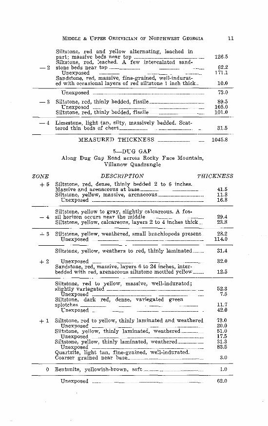
Siltstone, red and yellow alternating, leached in part; massive beds near top ---------------------- ----------------------Siltstone, red, leached. A few intercalated sand-
- 2 stone beds near top----------------------- ------------------------- _ -------·-------Unexposed -------------- --------------------------------------- ---------------------
Sandstone, red, massive, fine-grained, well-indurated with occasional layers of red siltstone 1 inch thick __
Unexposed
- 3 Siltstone, red, thinly bedded, fissile _____________ -----------------------Unexposed ______ ----------------------------- -----------------------··-------
Siltstone, red, thinly bedded, fissile------------------- -----------------
-4 Limestone, light tan, silty, massively bedded. Scat-tered thin beds of chert ------------------- _____ -------------------
MEASURED THICKNESS
5-DUG GAP Along Dug Gap Road across Rocky Face Mountain,
Villanow Quadrangle
11
126.5
62.2 171.1
10.0
73.0
89.5 105.0 101.0
31.5
1045.8
ZONE
+5 DESCRIPTION THICKNESS
Siltstone, red, dense, thinly bedded 2 to 6 inches. Massive and arenaceous at base _________ ----------------------- 41.5 Siltstone, yellow, massive, arenaceous. ______________ ---------------- 11.8
Unexposed ---------------------------------------------- ------------------- 16.8
Siltstone, yellow to gray, slightly calcareous. A fos+ 4 sil horizon occurs near the middle -------------------- 29.4
23.8 Siltstone, yellow, calcareous, layers 2 to 4 inches thick. __ _
+ 3 SiltstOne, ye11ow, weathered, small brachiopods present __ 28.2 114.0 Unexposed --------------- --------------------- ---------------------- ---------------
Siltstone, ye11ow, weathers to red, thinly laminated 31.4
+ 2 Unexposed _______ -------------------------------------- -------------------------- 32.0 Sandstone, red, massive, layers 6 to 24 inches, inter-bedded with red, arenaceous siltstone mottled yellow__ 12.5
Siltstone, red to yellow, massive, we11-indurated; slightly variegated ................................. ···························-· 52.3
Unexposed ---------------------- ----------------- ------------------------- 7.5 Siltstone, dark red, dense, variegated green splotches ------------------ ---------------- -------------------- ----------------------- 11.7
Unexposed ___ ------------------ ------------------- ------------------------ 42.0
+ 1 Siltstone, red to yellow, thinly laminated and weathered 73.0 Unexposed ________ ---------------------------------- --------------------------- 20.0
Siltstone, yellow, thinly laminated, weathered____ 51.0 Unexposed ----------------- ---------------- --------------------- ------------------- 17.5
Siltstone, yellow, thinly laminated, weathered_________________ 31.3 Unexposed ---------------------- ____ ------------- ---------------------- 83.5
Quartzite, light tan, fine-grained, well-indurated. Coarser grained near base ___ ------------------ -------------------------- 3.0
0 Bentonite, yellowish-brown, soft------------- ------------------------ _ 1.0
Unexposed _______ --------------- ------------------------ --------------------------- 62.0
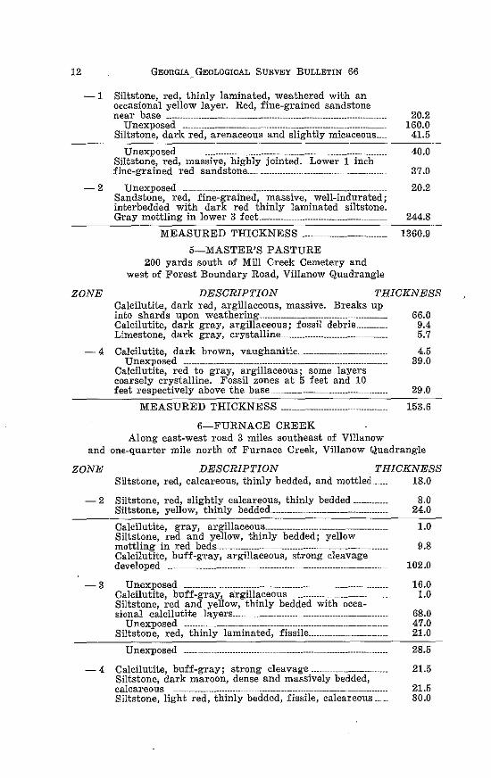
12 GEORGIA GEOLOGICAL SURVEY BULLETIN 66
-1 Siltstone, red, thinly laminated, weathered with an occasional yellow layer. Red, fine-grained sandstone near base _____ --------------- ------------.------- -----------------
Unexposed ------------------------------. -----------------------------------------Siltstone, dark red, arenaceous and slightly micaceous ___ _
20.2 160.0
41.5
Unexposed ------------------- ---------------------------- -------------------------- 40.0 Siltstone, red, massive, highly jointed. Lowe1· 1 inch fine-grained red sandstone _____ ------------------------------- 37.0
- 2 Unexposed ---------------------------------------------------------------------Sandstone, red, fine-g1·ained, massive, well-indurated; interbedded with dark red thinly laminated siltstone. Gray mottling in lower 3 feet ________ --------------------------------
MEASURED THICKNESS ··-- ------·········-·--········
5-MASTER'S PASTURE 200 yards south of Mill Creek Cemetery and
west of Forest Boundary Road, Villanow Quadrangle
20.2
244.8
1360.9
ZONE DESCRIPTION THICKNESS Calcilutite, dark red, argillaceous, massive. Breaks up into shards upon weathering .. _____________________________ ------------- 66.0 Calcilutite, dark gray, argillaceous; fossil debris___________ 9.4 Limestone, dark gray, crystalline__________________________ 5.7
- 4 Calcilutite, dark brown, vaug·hanitic._ ------------------------------ 4.5 Unexposed ------------------------------------------------------------------ 39.0
Calcilutite, red to gray, argillaceous; some layers coarsely crystalline. Fossil zones at 5 feet and 10 feet respectively above the base----------------_------------- 29.0
MEASURED THICKNESS -···- ----··············· 153.6
6-FURNACE CREEK Along east-west road 3 miles southeast of Villanow
and one-quarter mile north of Furnace Creek, Villanow Quadrangle
ZONE DESCRIPTION THICKNESS Siltstone, red, calcareous, thinly bedded, and mottled .. ____ 18.0
- 2 Siltstone, red, slightly calcareous, thinly bedded ------------Siltstone, yellow, thinly bedded ____________ -----------------------------Calcilutite, g-ray, argillaceous ____________________________________________ _ Siltstone, red and yellow, thinly bedded; yellow mottling in red beds--------------------------------------------------------------Calcilutite, buff-gray, argillaceous, strong cleavage developed __ ---------------------------- ---------------------------------------------
- 3 Unexposed --------------------------------------------- ----------------------------Calcilutite, buff-gray, a'rgillaceous -------------------------Siltstone, red and yellow, thinly bedded with occa-sional calcilutite layers __________________________ ------------------------------
0 nexposed ------------------------------ ------------------------------------------Siltstone, red, thinly laminated, fissile _____ -----------------------
Unexposed ---------------------------- ------------------- ---------------------------
8.0 24.0
1.0
9.8
102.0
16.0 1.0
68.0 47.0 21.0
28.5
-4 Calcilutite, buff-gray; strong cleavag·e _________ -------------- 21.5 Siltstone, dark maroon, dense and massively bedded, calcareous ------------.. ----------- ---------------------- ---------------- 21.5 Siltstone, light red, thinly bedded, fissile, calcareous_____ 30.0
MIDDLE & UPPER 0RDIVICIAN OF NORTHWEST GEORGIA
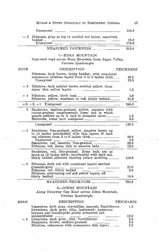
Unexposed
- 5 Siltstone, gray at top to mottled red below; massively bedded ------------------------------- --------------------------------- ---------------------
Unexposed ----------- -------------··---------- --------------------------------
MEASURED THICKNESS ___ ----------------------------
7-HORN MOUNTAIN East-west road across Horn Mountain from Sugar Valley,
Catoosa Quadrangle
199.5
18.2 178.0
813.0
13
'?ONE DESCRIPTION THICKNESS Siltstone, dark brown, thinly bedded; with occasional arenaceous siltstone layers from 4 to 6 inches thick__ 42.5
Unexposed ---------------------------------------------- ---------------------------- 23.5
+ 5 Siltstone, dark reddish brown mottled yellow. Occa-sional thin yellow layers ------------------------------- ----------------------- 1.5
+ 4 Siltstone, yellow, thick beds·---------------------------------------- 3.0 Siltstone, yellow, weathers to red, thinly bedded____________ 21.0
+3, +2, +1 Unexposed -------------------------------------------------------------- 245.0
0 Sandstone, medium-grained, yellow, massive with coarse-grained conglomeratic lower bed in which quartz pebbles up to 14 inch in diameter occur __ 1.5
0.5 Bentonite, lower part unexposed ____________ -----------------------------
Unexposed ___ ---------------------- -------------------- ____ ----------------------- 132.0
-1 Sandstone, fine-grained, yellow, massive layers up to 12 inches interbedded with thin layers of dark red siltstone from 2 to 6 inches thick ------------------ 39.0
Unexposed _______ ----------------- ----------------------------------------------- 2.0 Sandstone, red, massive, fine-grained______________________________ 22.0 Siltstone, red, dense, thin to massive beds___ 16.0
Sandstone, red, fine-grained. Some beds are as much as 12 inches thick; interbedded with dark red, thinly bedded siltstone showing yellow mottling 119.0
- 2 Siltstone, dark red with occasional layers mottled
ZONE
greenish-gray ----------- ----------------------------------------------------------- 27.0 Siltstone, red, thinly bedded --------------------------------------------- 5.0 Siltstone, alternating red and yellow layers, all thinly bedded ________ ------------------------------------- ----------------------- 19.0
MEASURED THICKNESS ______ -------------------------
8-JOHNS MOUNTAIN Along Dunaway Gap Road across Johns Mountain,
Catoosa Quadrangle
720.5
DESCRIPTION THICKNESS Limestone, dark gray, crystalline, sparsely fossiliferous 1.3 Limestone, dark gray, silty, laminated; numerous bryozoa and brachiopods poorly preserved and unidentifiable ------------------ -------------------- --------------------· 12.0
+ 1 Limestone, dark gray, silty, fossiliferous------------------------- 2.3 Sandstone, brown, medium-grained .. ___________________________ 1.5 Siltstone, calcareous with arenaceous thin layers 3.0
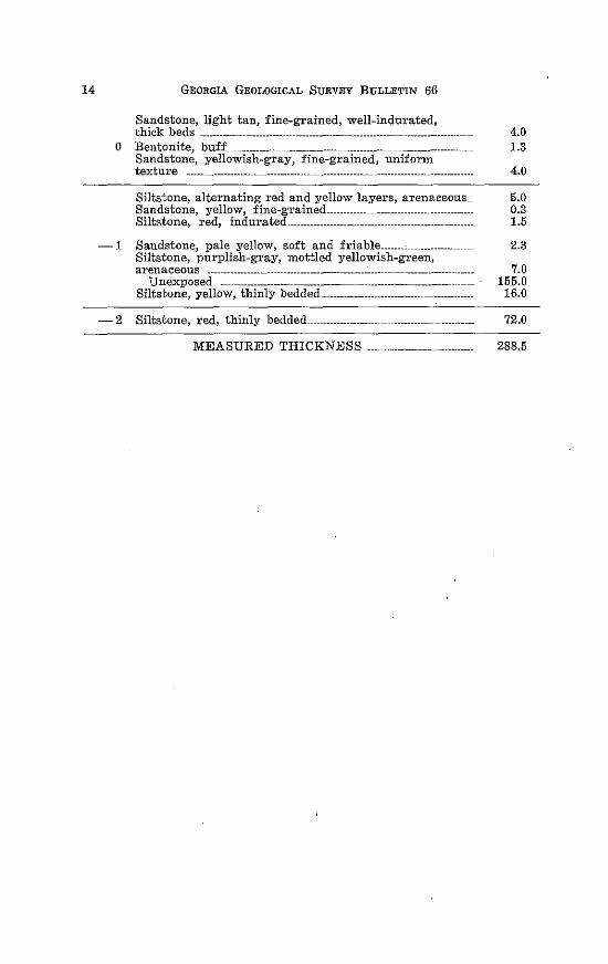
14 GEORGIA GEOLOGICAL SURVEY BULLETIN 66
Sandstone, light tan, fine-grained, well-indurated, thick beds ---------~---------- -------------------------------- --------------------- 4.0
0 Bentonite, buff ___________ -------------------------------- --------------------- 1.3 Sandstone, yellowish-gray, fine-grained, uniform texture -------------------------------- ------------------------------------------------ 4.0
Siltstone, alternating red and yellow layers, arenaceous__ 5.0 Sandstone, yellow, fine-grained_______________________________ 0.3 Siltstone, red, indurated ........... ----------------- ----------------- 1.5
-1 Sandstone, pale yellow, soft and friable________________________ 2.3
-2
Siltstone, purplish-gray, mottled yellowish-green, arenaceous --------------- -------------------------------- ------------------
Unexposed - ------------------- -------------- ---------------------------------Siltstone, yellow, thinly bedded ____________________________ ----------------
Siltstone, red, thinly bedded---------------------------------
MEASURED THICKNESS .
7.0 155.0
16.0
72.0
288.5
GE
OR
GIA
G
EO
LO
GIC
AL
S
UR
VE
Y
Cfl
z Q
1--0 w
C
fl
>w
_J
_J
'§!
:.: w
w
a:: 0 _
J
_J
::;; . <
, ~ ~
0 ' " 0 ~ ~ ~
" " " w
" "
0 " " • 0 ,
z • ~'nOllf~-
0 b '--"F--
PL
AT
E
2 0
"
D
[[]
16
Thickness:
GEORGIA GEOLOGICAL SURVEY BULLETIN 66
GENERAL DESCRIPTION OF
NEAR-SHORE ZONES
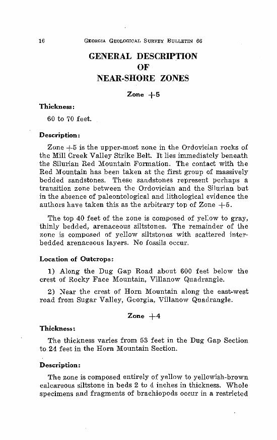
Zone +5
60 to 70 feet.
Description:
Zone +5 is the upper-most zone in the Ordovician rocks of the Mill Creek Valley Strike Belt. It lies immediately beneath the Silurian Red Mountain Formation. The contact with the Red Mountain has been taken at the first group of massively bedded sandstones. These sandstones represent perhaps a transition zone between the Ordovician and the Silurian but in the absence of paleontological and lithological evidence the authors have taken this as the arbitrary top of Zone +5.
The top 40 feet of the zone is composed of yellow to gray, thinly bedded, arenaceous siltstones. The remainder of the zone is composed of yellow siltstones with scattered interbedded arenaceous layers. No fossils occur.
Location of Outcrops:
1) Along the Dug Gap Road about 600 feet below the crest of Rocky Face Mountain, Villanow Quadrangle.
2) Near the crest of Horn Mountain along the east-west road from Sugar Valley, Georgia, Villanow Quadrangle.
Zone +4
Thickness:
The thickness varies from 53 feet in the Dug Gap Section to 24 feet in the Horn Mountain Section.
Description:
The zone is composed entirely of yellow to yellowish-brown calcareous siltstone in beds 2 to 4 inches in thickness. Whole specimens and fragments of brachiopods occur in a restricted
MIDDLE & UPPER 0RDIVICIAN OF NORTHWEST GEORGIA 17
horizon near the middle of the zone. None of the fragments are identifiable.
Location of Outcrops:
1) Along Dug Gap Road over Rocky Face Mountain, Villanow Quadrangle.
2) Along the east-west road over Horn Mountain running westward from Sugar Valley, Georgia, Villanow Quadrangle.
Fossils:
Brachiopods:
Hebertella, sp. Hesperorthis tricenaria (Conrad) 01·thorhynchula sp. Platystrophia sp. ( ?) Zygospira modesta (Hall)
Zone +3
Thickness:
28 feet.
Description:
At the only exposure of this zone it is composed of thinly bedded, yellow siltstone. A few beds are calcareous. Near the bottom of the zone there is a well-defined fossil horizon made up of fragments of unidentifiable brachiopods.
Location of Outcrops:
1) Along the Dug Gap Road over Rocky Face Mountain. Villanow Quadrangle.
Zone +2
Thickness:
Approximately 73 feet.
Description:
In the northern part of the strike belt, on Hamilton Mountain, the top of the zone is marked by a fine-grained yellowish
18 GEORGIA GEOLOGICAL SURVEY BULLETIN 66
sandstone in beds 2 to 8 inches thick which show slickensides along the bedding planes. To the south. at Dug Gap, the upper part of this zone is composed of thinly bedded, arenaceous, yellowish siltstone.
The middle part of the zone is not exposed.
The lower third of the zone is made up of red, massive sandstone interbedded with red to reddish-purple arenaceous siltstone showing mottling with yellowish spots. No fossils occur in this zone.
Location of OutcroPs:
1) On the east-west road across Hamilton Mountain which connects Georgia Highway 71 with the north-south road just east of Rocky Face Mountain, Dalton Quadrangle.
2) Along Dug Gap Road across Rocky Face Mountain, Villanow Quadrangle.
Zone +I
Thickness:
Thickness varies from 105 feet at Hamilton Mountain on the north to 400 feet at Dug Gap on the south. Thickening, in general, occurs from north to south in this strike belt.
Description:
The upper one-fourth of the zone is composed of red to yellow siltstone with an occasional mottled bed showing purplish splotches. A fine-grained, buff-colored sandstone occurs about 45 feet below the top of the zone.
The middle part of the zone at Hamilton Mountain is composed of red siltstone with a bed of conglomeratic sandstone 2 feet thick at its base. At Dug Gap the conglomeratic bed is absent.
The lower half of the zone is composed of red and yellow alternating beds of thinly laminated siltstone. About 5 feet above the base occurs a fossil horizon containing both identifiable and unidentifiable fragments of brachiopods and bryozoa. Farther south on Johns Mountain this part of the zone
MIDDLE & UPPER 0RDIVICIAN OF NORTHWEST GEORGIA 19
thins considerably and changes from siltstone to silty limestone. The fossil horizon occurs here about 3 feet above the base of the zone.
The lowest member of the zone is a bed of medium-grained yellowish sandstone about 2 to 4 feet thick. In some sections small pebbles randomly scattered through it give it a lose conglomeratic texture.
Location of Outcrops:
1) On Hamilton Mountain along the east-west road connecting Georgia Highway 71 with the north-south road just east of Rocky_ Face Mountain, Dalton Quadrangle.
2) On Dug Gap Road over Rocky Face Mountain, Villanow Quadrangle.
3) On Johns Mountain along the Dunaway Gap Road.
Fossils:
Brachiopods:
Ancistrorhyncha costata (Ulrich & Cooper) Camw1·otoechia sp. Orthorhynchula linneyi (James) Rhynchotrerna increbescens (Hall) R. rninnes·otensis (Sandeson) Sowerbyella sp. Zygospiro recurvirostris (Hall)
Zone 0
Thickness:
From 2 to 4 feet.
Description:
The 0 Zone is a bed of bentonite of fairly uniform thickness which is not associated with chert in this strike belt as it is in the snike belts to the west.
The bentonite is yellowish-brown to yellowish-green in color, of fine texture with minute flakes of biotite generously scattered through it and an occasional fragment of feldspar.
20 GEORGIA GEOLOGICAL SURVEY BULLETIN 66
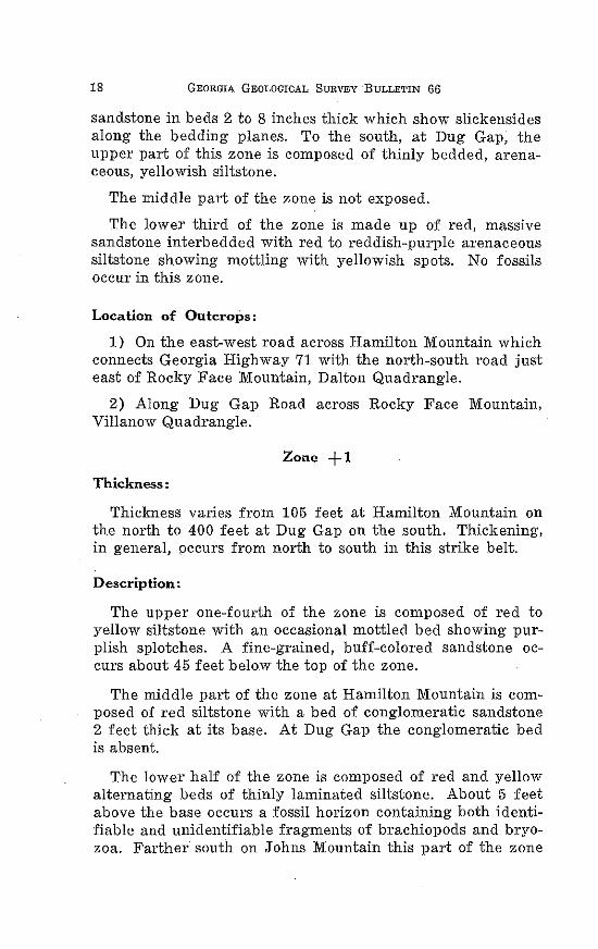
Location of Outcrops:
1) On Hamilton Mountain along east-west road from Georgia Highway 71 to north-south road just east of Rocky Face Mountain, Dalton Quadrangle.
2) Along U. S. Highway 41 near the site of Hassler's Mill. (Mill destroyed by fire in 1955.), Tunnel Hill Quadrangle.
3 ) Along Dug Gap Road over Rocky Face Mountain, Villanow Quadrangle.
4) On Horn Mountain along the east-west road from Sugar Vall ey, Georgia, Villanow Quadrangle.
5) Near the crest of Johns Mountain along the Dunaway Gap Road .
Figure 1. Bentonite overlying mas ive quartzite in roadcut of U. S. Highway 41 at Hassler's Mill.
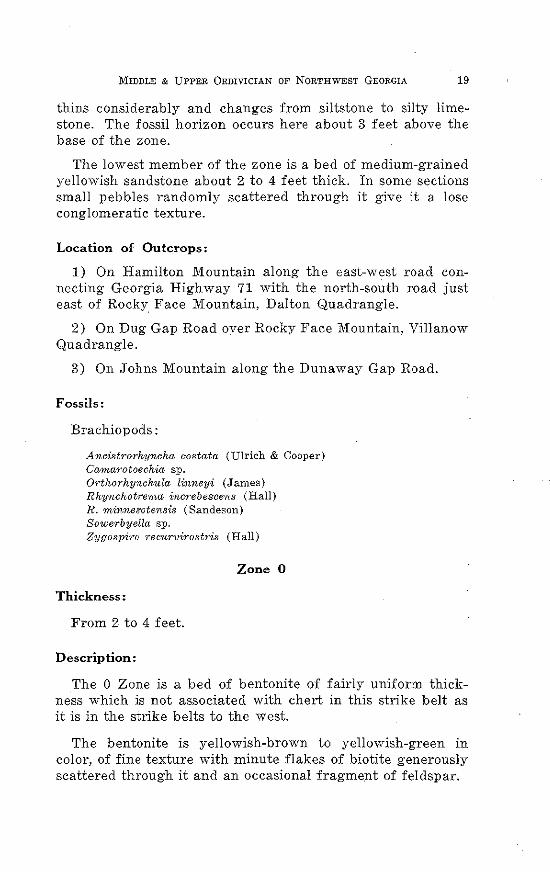
Zone -1
Thickness:
The average thickness of Zone -1 is 220 feet . The greatest thickness being in the Dug Gap Section and the least thickness on Johns Mountain.
Description:
The zone is predominantly composed of red and ye llow
MIDDLE & UPPER 0RDIVICIAN OF NORTHWEST GEORGIA 21
si ltstone which alternate with irregu larity. The top of the zone is marked in the north and south ends of the strike belt by a 4 foot bed of ye llowish sandstone; in the central part of the strike belt the sandstone is replaced by a bed of arenaceous siltstone. In the Hamilton Mountain and Mill Creek Sections, a fossil horizon occurs in a ye llow si ltstone about 20 feet below the top of the zone . W eathering, however, has mad e identification of fossil very difficult. Scattered through the zone in th northern and southern parts are three or four thin beds of yellowish-gray sandstone which may or may not contain mall scattered quartz pebbles.
Figure 2. Jointing in siltstone of -1 Zone in roadcut of U. S. Highway 41 west of Hassler's Mill.
Location of Outcrops:
1) On Hamilton Mountain along the east-west road from Georgia Highway 71 to the north-south road just east of Rocky Face Mountain, Dalton Quadrangle.
2) Along U. S. Highway 41 just south of the site of Hassler's Mill, Tunnel Hill Quadrangle.
3 ) On Horn Mountain along east-west road from Sugar Vall ey, Georgia, Vi ll anow Quadrangle.
4) On Johns Mountain along the Dunaway Gap Road.
22 GEORGIA GEOLOGICAL SURVF.Y BULLETIN (j(j
Fossils:
Brachiopods : Camat·otoechia sp. ( ?) S owet·byella sp. (?)
Thickness:
Zone -2
The average thickness of Zone - 2 is 378 feet. Complete zones are found in four of the measured sections and partial thicknesses occur in three others.
The zone is composed predominantly of red siltstone with thin and massive beds. When thin bedded an occasional yellowish bed will occur but when massive the yellow beds are absent.
Generally the zone will show several thin beds of brown
Figure 3. Sandstone layer in -2 Zone on west side of Rocky Face Mountain at Dug Gap.
MIDDLE & UPPER 0RDIVICIAN OF NORTHWEST GEORGIA 23
to deep red sandstone. Near the sandstone beds the siltstone shows an increase in sandy material. No fossils are found in this zone.
Location of Outcrops: Complete sections occur.
1) On Hamilton Mountain along east-west road from Georgia Highway 71 to the north-south road just east of Rocky Face Mountain, Dalton Quadrangle.
2) On Rocky Face Mountain along Dug Gap Road, Villanow Quadrangle.
3) Along road going east from the village of Rocky Face, Tunnel Hill Quadrangle.
4) Along U. S. Highway 41 about one-fourth mile south of the site of Hassler's Mill, Tunnel Hill Quadrangle.
Zone -3
Thickness:
The thickness of the zone varies from 265 feet at Furnace Creek to 557 feet at Hamilton Mountain. The average thickness is 396 feet.
Description:
On the Hamilton Mountain, New Hope Church, and Mill Creek Sections, all in the northern part of the strike belt, the . zone is made up entirely of siltstone and arenaceous siltstone. Colors range from yellowish, to reddish- to chocolate-brown. Bedding varies from thin to massive. East of the village of Rocky Face the lower siltstone is replaced by gray calcilutite. At Furnace Creek calcilutite replaces the siltstone in the middle and upper portions of the zone.
No fossils are found in the zone.
Location of Outcrops:
1) Near New Hope Church about 4 miles north of Dalton, Georgia.
2) On Hamilton Mountain along east-west road from Georgia Highway 71 to north-south road just east of Rocky Face Mountain, Dalton Quadrangle.
24 GEORGIA GEOLOGICAL SURVEY BULLETIN 66
3) Off of a county road running east from the village of Rocky Face, Tunnel Hill Quadrangle.
4) Along U. S. Highway 41 about 1 mile south of Hassler's Mill site, Tunnel Hill Quadrangle.
5) Along east-west road which crosses Horn Mountain and East Armuchee Valley about one-fourth mile north of Furnace Creek, Villanow Quadrangle.
Zone -4
Thickness:
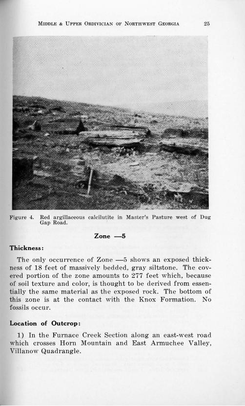
Zone -4 is 101 feet thick in the Furnace Creek Section and 182 feet in the Master's Pasture Section. No complete thickness of the zone occurs, perhaps because of the solubility of the rock comprising it.
D~scription:
In the Master's Pasture Section the rock is for the most part argillaceous calcilutite with both thin and massive beds. The colors range from gray to brownish-gray to red and maroon. Seventy-five feet from the top of the zone is an upper Solenopora horizon. Two lower horizons of Solenopora occur at 5 feet and 10 feet above the bottom of the zone.
In the Furnace Creek Section, which lies several miles south of Master's Pasture, the rocks are buff to gray calcilutite and light red to maroon calcareous siltstone. Both thin and massive beds occur. No fossils appear in the Furnace Creek Section.
Location of Outcrops:
1) The Master's Pasture Section lies west of the Dug Gap Road and in the flats west of Rocky Face Mountain, Villanow Quadrangle.
2) The Furnace Creek Section along an east-west road which crosses Horn Mountain and East Armuchee Valley, Villanow Quadrangle.
Fossils:
Alga:
Solenop01·a sp.
MIDDLE & UPPER 0RDIVICIAN OF NORTHWEST GEORGIA 25
Figure 4. Red argillaceous calcilutite in Master's Pasture west of Dug Gap Road.
Zone -5
Thickness:
The only occurrence of Zon e -5 shows an exposed thickness of 18 feet of massively bedded, gray siltstone. The covered portion of the zone amounts to 277 feet which, because of soil texture and color, is thought to be derived from essentially the same material as the exposed rock. The bottom of this zone is at the contact with the Knox Formation. No fossils occur.
Location of Outcrop :
1) In the Furnace Creek Section along an east-west road which crosses Horn Mountain and East Armuchee Valley, Villanow Quadrangle.
26 GEORGIA GEOLOGICAL SURVEY BULLETIN 66
OFFSHORE FACIES Introduction:
The Ordovician limestone facies extend westward from Rabbit Valley through Lookout Valley. Although individual horizons show considerable variation from one area to another, the overall stratigraphy is remarkably uniform.
The data are presented in the same manner as previously for Mill Creek Valley. Zone -12 and -13 are included in the measured sections and general descriptions although they do not rightfully fit into the problem. Zone -12 and -13 (Newala of former nomenclature) correlate with the upper Knox of Tennessee and Alabama. They have a distinctive, uniform lithology, however, and have been used as a lower datum plane.
RABBIT VALLEY STRIKE BELT SECTIONS
1-FRIENDSHIP CHURCH East and west of Georgia Highway 151,
4 miles north of Ringgold, Ringgold Quadrangle
ZONE DESCRIPTION THICKNESS +1 Siltstone, reddish-yellow, slightly calcareous with
stringers of white to pink calcite --------------------------------------- 20.0 ~~-:::-~
0 Bentonite with associated greenish-gray chert._________________ 1.6
Unexposed 20.0
-1 Limestone, dense, medium gray, thinly bedded with greenish argillaceous partings______________________________________________ 15;6
Unexposed -------------------------------------------------- --------------- 26.3
-2 Calcilutite1 light gray, crystalline in beds 8 to 18 inches thick --------------------------------------------------------------------- 10.7
-3 Unexposed ___ _ 58.7
-4 Limestone, medium gray, coarsely crystalline, fos-siliferous. Weathers to thin shards ____ ----------------------·--····· 29.5 Limestone, blue-gray, coarsely crystalline. Coquina horizon 5 feet above base__________ -------------------------------- 10.3 Pseudo limestone conglomerate appearance by colo-nies of Solenopora SP----------------------------- ------------------------------ 1.0
-5 Calcilutite, light gray, very argillaceous~ mottled; massive beds weathers into small rounded shards__ 15.5
-6 Poorly exposed to unexposed_ -----------------------------------------
-7 Limestone, very light gray, coarsely crystalline in beds 8 to 18 inches thick. Scattered layers of dark
58.5
gray calcilutite. Fossils abundant in some layers____________ 14.7
-8
-9
MIDDLE & UPPER 0RDIVICIAN OF NORTHWEST GEORGIA
Limestone, thinly bedded, coarsely crystalline with pale reddish color ________________________________ _
Unexposed ------------------------------
Limestone, dark gray, finely crystalline with scattered brown chert nodules -------------------- --------------------------------
Unexposed
-10 Limestone, gray, thinly bedded, coarsely crystalline, very fossiliferous, interbedded with thin calcilutite Calcilutite, gray, thinly laminated _____________________________ _ Calcilutite, dark gray with scattered chert nodules. Fossil horizon near base ______________________________________________________ ,
Limestone, gray, massively bedded, argillaceous with small amount of secondary chert ________________________ _
Unexposed ________ _ -11 Siltstone, calcareous, red, greenish yellow, light
brown, thinly bedded. Weathers to small prismatic fragn1ents ----------------------------------------------- ----------------------Calcilutite, buff colored with argillaceous partings ___ _
Unexposed -----------------------------Calcilutite, dark gray, dense, thinly bedded, sparsely fossiliferous ------------------------------------------------------
Unexposed ----------------------- ----------------------------··· Calcilutite, medium gray; thin cobbly bedding, argillaceous with fossil debris. Mud chip polygons common in thinner laminae ________________________________________________ _ Calcilutite, dark gray argillaceous with black ropy chert nodules -------------------------------- -----------------------Calcilutite, dark gray massively bedded with argillaceous partings. Abundant bryozoa debris __
Unexposed -------------------------- -------------------------------------------------
Unexposed
-12 Calcilutite, dark gray, dense, thinly bedded ______________ _ Unexposed -------------------- -------------------------------------------------
-13 Calcilutite, dark gray, thinly bedded; mud polygons abundant ---------- ------------------------------------- -----------------------Calcilutite, red and gray argillaceous __ -----------------------------
MEASURED THICKNESS --·····················---·
2-PLEASANT VALLEY West from Georgia Highway 151,
three miles north of Ringgold, Ringgold Quadrangle
27
9.4 47.0
13.7
29.0
24.2 20.9
8.0
19.8 21.4
28.6 2.0
21.4
22.8 6.7
28.5
18.2
3.2 23.5
30.0
16.0 67.0
148.0 82.0
973.7
ZONE DESCRIPTION Limestone, grayish-brown, coarsely crystalline __
THICKNESS 20.7
-7 Calcilutite, dark gray, massive, coarsely crystalline and fossiliferous ---------------- --------------------------------------------- 2.0 Limestone, light gray, coarsely crystalline. A fossil horizon in lower two feet_______ _ _____________ --------------------------- 10.0
-8 Calcilutite, thinly bedded, light gray with scattered crystalline fossiliferous layers. A few chert nodules at top -------------- ------------------------------------------ ------------------------ 10.4
Unexposed _______________ ----------- --------------------------------- --------------- 35 .4
28 GEORGIA GEOLOGICAL SURVEY BULLETIN 66
-9 Calcilutite, gray, massively bedded with thin laminations and showing small amount of secondary buff-colored chert ________ ------------------- -------------------- ---------------- 12.6
Calcilutite, dark gray, medium bedded, argillaceous with black chert nodules and th:n cobbly bedding near top ---------- ------------------ ------------------- --------------- ___________ ______ 22.0
-10 Calcilutite, dark gray, medium bedded, highly argil-laceous; numerous fossil fragments_____________________ _____ 25.3 Siltstone, red to yellow to green, calcareous; weath-ers to small prismatic fragments ---------------- 47.5
Unexposed ----------------- -------------------- ---------------------------- 20.5
Calcilutite, dark gray, highly argillaceous; some fossil layers ----------------------------------- --------------------- 84.0 Calcilutite, dark gray, dense, thinly bedded __ -------------------- 10.1
-11 Calcilutite, dark gray, dense, massively bedded__ 7.0 Calcilutite, dark gray, argillaceous, fossiliferous___________ 34.0 Calcilutite, black, thinly bedded, slightly crystalline______ 31.0
MEASURED THICKNESS ________ ------------------- _
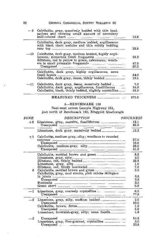
3-BENCHMARK 120 East-west across Georgia Highway 151,
just north of Benchmark 120, Ring·g·old Quadrangle
372.5
ZONE +2
DESCRIPTION THICKNESS Limestone, gray, massive, fossiliferous ----------------- 15.1
+1
0
-1
-2
-3
Unexposed ------------------------------------- ----------·---- -------------------- 83.5
Limestone, dark gray, massively bedded-------------
Calcilutite, medium gray, silty; weathers to rounded outcrops ------------------------ -------------------------------------- ------------------
Unexposed -------------------- ---------------·---------------------- __ ---------·--Calcilutite, medium-gray, silty _____________ --------------------
Unexposed --------- ------------------------------------------ ---------------
Calcilutite, mottled brown and g-reen ------------------------Limestone, gray, silty_____________ -------------------------------Siltstone, red, thinly bedded ..... _ ------------------- ----------------Limestone, gray, silty ------------------ ------------------- --------------Siltstone, red, thinly laminated --------- ---------------- ---------------Calcilutite, mottled brown and green ··---------------------Calcilutite, gray, mud cracks, pink calcite stringers in joints· --------------------- ------------------------ ------------------ -----------------
Unexposed ---------------------- --------------------------------------Bentonite _________ ---------------- ----------------- --------------Green chert --------- ------------------------- ----------------- -------------------
Limestone, gray, coarsely crystalline~----Unexposed _____ ------------------------- -------------------- ----------------------
Limestone, gray, silty, medium bedded-----------------------------Unexposed --------------------------- ------------------ ---------------
Calcilutite, brown, dense ............ -------------------- ------.. ·-------------Unexposed --------------------------------------- --------------------
Limestone, brownish-gray, silty; some fossils-----------------
Unexposed --------------------------- ------------------------Limestone, gray, fine-grained, crystalline __ ------------------
Unexposed ____ ------------------------ ---------------- ----------------------
12.2
37.0 15.0 33.5 31.5
3.3 4.0
22.3 1.0 7.0 3.3
6.5 6.6 2.5 0.8
6.5 77.5
2.0 10.0
1.0 5.5 1.0
54.5 3.0
33.5
MIDDLE & UPPER 0RDIVICIAN OF NORTHWEST GEORGIA
Calcilutite, dark gray to brownish-gray __ Unexposed ___ ------------------------------------------------- ----------------------
Limestone, gray, coarsely crystalline, fossiliferous _________ _
-4 Limestone, poorly exposed zone covered with shards of gray crystalline limestone and chert ___________ ------------------Limestone, gray, silty with thin, tan chert stringers __
Unexposed --------------- -----------------------------Limestone, gray, argillaceous----------------------------------------------
-5 _U::.=ne::x::'p':o':s::ed::_:-::----------=---::--::--=-::--::---::--::--::--::---::--::--::--::··:::::::::::··-------------Calcilutite, gray, argillaceous------------------------Calcilutite, gray, massive, even-textured ______________ _
Unexposed --------------------------------- ______________________________ _
-6 Limestone, gray, massively bedded with scattered yellow silt splotches -------------------------
Unexposed ------------------------------------- ----------------Calcilutite, gray, dense ... -----------------------------------------------------
Unexposed ------------------------------------- --------------------------------------Limestone, gray to black.__________ _ ____________ ------------------Calcilutite, brown to black, thinly bedded __
-7 Calcilutite, gray with brown chert nodules __ Calcilutite, black, massively bedded with silt stringers __
Unexposed _ ----·--------------------------------------------------------Calcilutite, black, massively bedded __
Limestone, gray with calcite "eyes" __
-8 Calcilutite, dark gray._ Unexposed ----------------------------------------------------------------------
-9 Calcilutite, brown with white to clear calcite "eyes"--------
Limestone, gray, silty, thinly bedded; mud cracks; thin alternating light and dark laminae--------------------
Unexposed -~---- ___________ -------------------· Siltstone, alternating red and yellow, thinly bedded, slightly calcareous _____ ---------------------------
-10 Limes~one, gray, silty with abundant mud cracks ___________ _ Calcilutite, black to gray alternating with limy siltstone Limestone, dark brown, thinly bedded, silty __________ _
Unexposed ----------------------------------------------- ---------------------
---..,.-11 Siltstone, red and yellow, thinly bedded; the red beds more resistant to weathering ______ _
MEASURED THICKNESS ___ ----------------------------
4-CHICKAMAUGA CREEK 1 mile north of Ringgold,
3.7 11.6
2.0
16.2 7.8
28.0 2.0
29.6
6.5 2.3
19.0
27.0 203.0
2.0
49.5 2.0
18.0
8.8 15.5 39.0 15.6
12.2
5.0 18.6
13.0
2.6 44.0
21.0
12.7 10.6 15.6 10.8
110.5
1263.6
eastward from meander in Chickamauga Creek, Ringgold Quadrangle
29
ZONE DESCRIPTION THICKNESS Limes~one, medium gray, silty with calcite string-ers; fossil horizon·---------------------------------------------------- 12.5
Unexposed ______________ 10.0 Limestone, gray, silty, weathers to small pebbles; fossils abundant 40 feet above base______________________________________ 65.0
Unexposed ---------------------- 11.0
30 GEORGIA GEOLOGICAL SURVEY BULLETIN 66
+1 Limestone, gray, crystalline with stringers of silt present ___ -------------------------------c------------------------- --------------·------ 8.5
Unexposed --------------- ___ ------------------------------- --------------------- 47.0 Limestone, gray, silty------------------------------------------------ 3.0
Unexposed ------------------------------------- -------------------------------- 6.0 Limestone, gray, fine-grained __________ ---------------------------------- 2.0
Unexposed -------------------------------------------- --------------------- 5.0 Limestone, gray, silty--------------------------------------- ------------------- 5.0
Green chert ----------------------------------------------------------------------------- 0.5 Unexposed ---------------------------------- --------------------------- 17.0
0 Siltstone, brown, calcareous ----------------------------------------- 27.4 Unexposed --------------------------------------------------------------------------- 29.2
Bentonite, yellowish brown ------------------------- 3.0 Green chert -------------------- ---------------------------------------------------- 0.5
Calcilutite, gray-brown alternating with beds of crystalline gray limestone ---------------------------------------
Unexposed ----------------------------- ----------------------45.2
7.5
-1 Limestone, g-ray, fine-grained______________________ ----------------- 5.5 Limestone, pinkish-gray, coarsely crystalline._ 4.1 Limestone, brownish-gray, siltY-------------------------------------- 8.3
-2 Unexposed -------------- ----------------------------------------------------------- 38.7
-3 Limestone, medium gTay, coarsely crystalline, fossiliferous; alternating with 6 inch layers of silty limestone --------------------------- ----------------------------------- 43.0
Unexposed -----------~------------------ ------------------------------------------- 93.0
-4 Limestone, lig-ht gray; crystalline with calcite stringers. A 12 inch bed of brown calcilutite 3 feet above base ------------------------------------------------------------------------- 6.9
Unexposed ------------------------------------------ ---------------------- 36.5 Limestone, brown, siltY-------------------------------------- 5.8 Limestone, Iig·ht gray, crystalline, fossiliferous_______________ 2.0 Calcilutite, brownish-gray ------------------------------------------------ 4.1
Unexposed _ ------------------------------------------- --------------------- 16.0
-5 Limestone, pinkish-gray, coarsely crystalline, mas-sively bedded ________ -------------------------------- --------------------- 6.1
-6 Limestone, gray, thinly bedded, silty, fossiliferous; weathers with knobby surface ______ ------------------------------------- 74.0
MEASURED THICKNESS 649.3
5-MADDOX GAP Along Lookout Scenic Highway
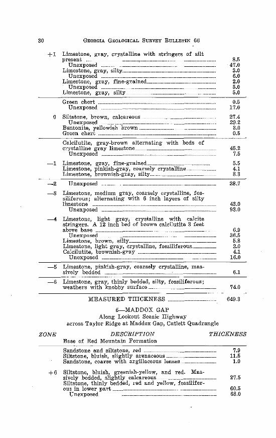
across Taylor Ridge at Maddox Gap, Catlett Quadrangle
ZONE DESCRIPTION Base of Red Mountain Formation
THICKNESS
Sandstone and siltstone, red _____ ------------------------------------------ 7.9 Siltstone, bluish, slightly arenaceous-------------------------------- 11.5 Sandstone, coarse with argillaceous lenses __ --------------------- 1.0
+6 Siltstone, bluish, greenish-yellow, and red. Mas-sively bedded, slightly calcareous________________________________________ 27.5 Siltstone, thinly bedded, red and yellow, fossilifer-ous in lower part--------------------------------------------------- 60.5
Unexposed _______________ --------------------------- _______________ 68.0
MIDDLE & UPPER 0RDIVICIAN OF NORTHWEST GEORGIA
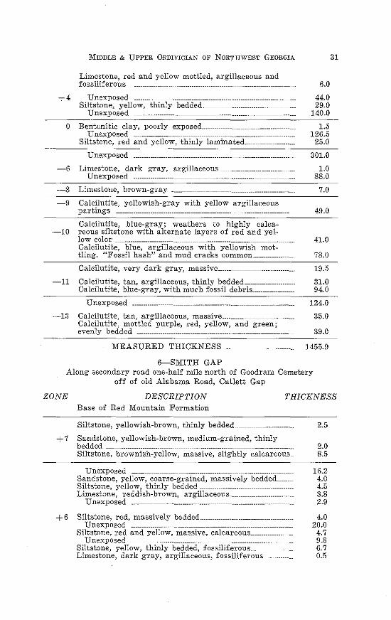
Limestone, red and yellow mottled, argillaceous and fossiliferous ___ ---------------------------- ___ ------------------------- 6.0
+4 Unexposed --------- ------------------------------------ 44.0 Siltstone, yellow, thinly bedded __ 29.0
Unexposed ----------------------------------------------------- _ ------------------- 140.0 ---=-0 Bentonitic clay, poorly exposed ___ --------------------------------- 1.5
Unexposed ------------------ ------------------ 126.5 Siltstone, red and yellow, thinly laminated.---------------------- 25.0
Unexposed 301.0
-6 Limestone, dark gray, argillaceous ------------------------------- 1.0 Unexposed ---------------- ----------------------- ---------------- _________________ _ 88.0
-8 Limestone, brown-gray ______ -------------------------------------------------- 7.0
-9 Calcilutite, yellowish-gray with yellow argillaceous partings -------------------------------- -------------------------------------------- 49.0
Calcilutite, blue-gray; weathers to highly calca--10 reous siltstone with alternate layers of red and yel-
low color ----------------------- ------------------------------------- -------------------- 41.0 Calcilutite, blue, argillaceous with yellowish mot-tling. "Fossil hash" and mud cracks common _______________ _ 78.0
Calcilutite, very dark gray, massive ______ ----------------------------- 19.5
-11 Calcilutite, tan, argillaceous, thinly bedded _______________________ _ 31.0 Calcilutite, blue-gray, with much fossil debris __________________ _ 94.0
Unexposed ------------ ----------------------------------------- -------------------- 124.0
-13 Calcilutite, tan, argillaceous, massive _________________________ _ 35.0 Calcilutite, mottled purple, red, yellow, and green; evenly bedded ------------------------- --------------------------------------- 39.0
MEASURED THICKNESS .................. . 1455.9
6-SlVIITH GAP Along secondary road one-half mile north of Goodram Cemetery
off of old Alabama Road, Catlett Gap
31
ZONE DESCRIPTION Base of Red Mountain Formation
THICKNESS
Siltstone, yellowish-brown, thinly bedded --------------------------- 2.5
+ 7 Sandstone, yellowish-brown, medium-grained, thinly bedded ---------·-------------- -----------------··---·--··---- ----------------·-·---------·-· 2.0 Siltstone, brownish-yellow, massive, slightly calcareous__ 8.5
Unexposed ______ -------------------------------------- -------------------------- 16.2 Sandstone, yellow, coarse-grained, massively bedded__ 4.0 Siltstone, yellow, thinly bedded---------------------- -------------- 4.5 Limestone, reddish-brown, argillaceous ---------------------------- 3.8
Unexposed ____ ---------------------------------- ________ ------------------ 2.9
+ 6 Siltstone, red, massively bedded -------------------------- ---------------- 4.0 Unexposed -------------------- ------------------------- ------------------------- 2 0. 0
Siltstone, red and yellow, massive, calcareous__________________ 4.7 Unexposed --------------------- -------------------------------------- 9 .8
Siltstone, yellow, thinly bedded, fossiliferous____________________ 6.7 Limestone, dark gray, argillaceous, fossiliferous______________ 0.5
32 GEORGIA GEOLOGICAL SURVEY BULLETIN 66
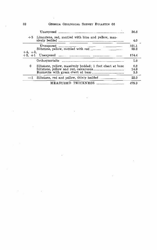
Unexposed ----------- 36.6
+ 5 Limestone, red, mottled with blue and yellow, mas-sively bedded ____ ---------------- ---------------------- ----------------------- 4.0
+4, +2,
Unexposed --------------------- ---------------------- -------------------------------Siltstone, yellow, mottled with red------------------------------------
+3, +1 Unexposed -------. ---------------------------------------------------
Orthoquartzite --------------------
0 Siltstone, yellow, massively bedded; 1 foot chert at base Siltstone, yellow and red, calcareous ......... _----------------------Bentonite with green chert at base --------------- ---------------------
-1 Siltstone, red and yellow, thinly bedded----------------------
MEASURED THICKNESS ............... ----------·-···-
101.1 29.0
174.4
1.0
6.2 14.0
1.5
22.0
479.9
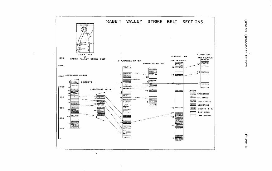
~~~0
1400
INDEX MAP
" RABBIT VALLEY STRIKE BELT
1200 I-FRIENDSHIP CHURCH
1000
'"
'"
"'
'"
0
RABBIT VALLEY STRIKE
3-BENCHMARK NO. 120
BELT SECTIONS
6-SMITII GAP
~ SilTSTONE
""" CALCILUTITE
~ LIMESTONE -CIIERTV l. s.
= BENTONITE = UNEXPOSED
34 GEORGIA GEOLOGICAL SURVEY BULLETIN 66
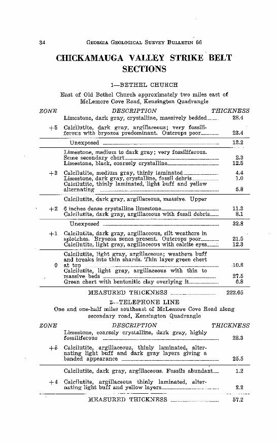
CHICKAMAUGA VALLEY STRIKE BELT SECTIONS
1-BETHEL CHURCH
East of Old Bethel Church approximately two miles east of McLemore Cove Road, Kensington Quadrangle
ZONE DESCRIPTION THICKNESS Limestone, dark g-ray, crystalline, massively bedded________ 28.4
Calcilutite, dark gray, argillaceous; very fossili-ferous with bryozoa predominant. Outcrops poor _____ _ 23.4
Unexposed ----------------------- ______________ _ 13.2
Limestone, medium to dark gray; very fossiliferous. Some secondary chert·------------------------------------------------------ 2.3 Limestone, black, coarsely crystalline--------------------------------- 12.5
+3 Calcilutite, medium gray, thinly laminated______________________ 4.4 Limestone, dark gray, crystalline, fossil debris___ 1.0 Calcilutite, thinly laminated, light buff and yellow alternating ----------------------------------------------------------------------------- 5 .8
Calcilutite, dark gray, argillaceous, massiye. Upper
+2 6 inches dense crystalline limestone____________________________________ 11.3 Calcilutite, dark gray, argillaceous with fossil debris______ 8.1
Unexposed 32.8
+ 1 Calcilutite, dark gray, argillaceous, silt weathers in splotches. Bryozoa zones present. Outcrops poor___________ 21.5 Calcilutite, light gray, argillaceous with calcite eyes ____ ~- 12.3
Calcilutite, light gray, argillaceous; weathers buff and breaks into thin shards. Thin layer green chert
0 at top --·-.. ----·-.. ·-.. -......... _.-.... --.--.. ·--·-....................... 10.8 Calcilutite, light gray, argillaceous with thin to massive beds ----------------------------------------------------------------------- 2 7.5 G1•een chert with bentonitic clay overlying it 6.8
MEASURED THICKNESS __ 222.05
2-TELEPHONE LINE One and one-half miles southeast of McLemore Cove Road along
secondary road, Kensington Quadrangle
ZONE DESCRIPTION THICKNESS Limestone, coarsely crystalline, dark gray, highly fossiliferous ---------------------------------------------------------------------------- 28.3
+ 5 Calcilutite, argillaceous, thinly laminated, alter-nating light buff and dark gray layers giving a banded appearance ---------------------------------------------------------------- 2 5. 5
Calcilutite, dark gray, argillaceous. Fossils abundant____ 1.2
+ 4 Calcilutite, argillaceous thinly laminated, alter-nating· light buff and yellow layers______________________________________ 2.2
MEASURED THICKNESS .. -·-----·----------------.... ·- 57.2
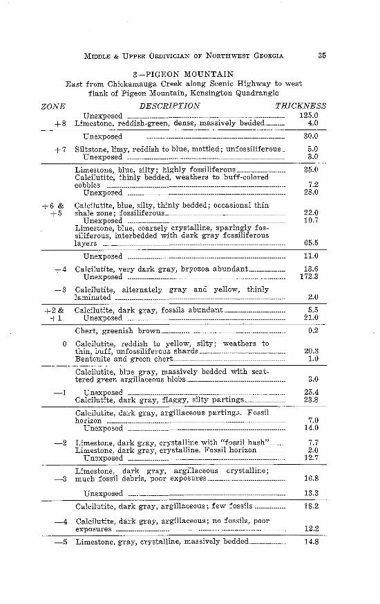
MIDDLE & UPPER 0RDIVICIAN OF NORTHWEST GEORGIA 35
3-PIGEON MOUNTAIN East from Chickamauga Creek along Scenic Highway to west
flank of Pigeon Mountain, Kensington Quadrangle
ZONE DESCRIPTION THICKNESS Unexposed --------------------------- ---------------------- 125.0
+8 Limestone, reddish-green, dense, massively bedded__________ 4.0
+7
+6 & +5
+4
+3
+2& +1
Unexpos~d
Siltstone, limy, reddish to blue, mottled; unfossiliferous .. Unexposed -----------------------.. ·--------------------
Limestone, blue, silty; highly fossiliferous-----------------------Calcilutite, thinly bedded, weathers to buff-colored cobbles ------------------------------------------------------------------------------------
Unexposed ---------- --------------------------------------
Calcilutite, blue, silty, thinly bedded; occasional thin shale zone; fossiliferous __ -----------------------------
Unexposed ________________ _ Limestone, blue, coarsely crystalline, sparingly fossiliferous, interbedded with dark gray fossiliferous layers ----------
Unexposed -----------------Calcilutite, very dark gray, bryozoa abundant _________________ _
Unexposed --------------------------- _________ ------------------------------
Calcilutite, alternately gray and yellow, thinly laminated ---------------------------- ------------------------------- ---------------------
Calcilutite, dark gray, fossils abundant -----------------------------Unexposed ___ ------------------------------------------------
Chert, greenish brown .... -----------------
30.0
5.0 3.0
35.0
7.2 28.0
22.0 10.7
65.5
11.0
13.6 172.3
2.0
5.5 21.0
0.2
0 Calcilutite, reddish to yellow, silty; weathers to thin, buff, unfossiliferous shards-------------- --------------------------- 20.3 Bentonite and green chert.. 1.0
Calcilutite, blue gray, massively bedded with scat-tered green argillaceous blebs ____________________ _ 3.0
-1 Unexposed ---------------------------------- ---------- ---------------------------· ... 25 .4 Calcilutite, dark gray, flaggy, silty partings._ 23.8
Calcilutite, dark gray, argillaceous parting;;;. Fossil horizon ------------ ------------------ --------------------------------- 7.0
Unexposed -------------------------------------------------------- 14.0
-2 Limestone, dark gray, crystalline with 11fossil hash" 7.7 Limestone, dark gray, crystalline. Fossil horizon__ 2.0
Unexposed ------------------------ ---------------------------- 12.7
Limestone, dark gray, argillaceous crystalline; -3 much fossil debris, poor exposures_____________________________________ 16.8
Unexposed _____ ----------------------- ----------------------------------------------- 13.3
Calcilutite, dark gray, argillaceous; few fossils--------------- 18.2
-4 Calcilutite, dark gray, argillaceous; no fossils, poor exposures ------------ --------------------------------------------- 12.2
-5 Limestone, gray, crystalline, massively bedded__________________ 14.8
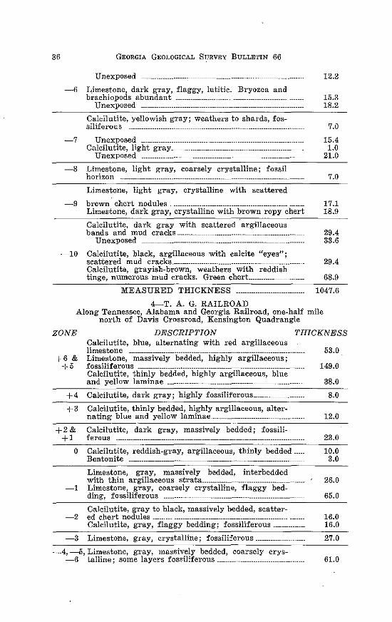
36 GEORGIA GEOLOGICAL SURVEY BULLETIN 66
Unexposed 12.2
-6 Limestone, dark gray, flaggy, lutitic. Bryozoa and brachiopods abundant ------------------------------ ----------------- 15.3
Unexposed -------------------------------------------------------------------------- 18.2
Calcilutite, yellowish gTay; weathers to shards, fos-siliferous --------------------- ------------------------------------------------------- 7.0
-7 Unexposed . --------------------------- _ ------------------------------- 15.4 Calcilutite, light gray_------------------------------------------------- 1.0
Unexposed ------------------- -------------------- -------------------------------. 21.0
-8 Limestone, lig·ht gray, coarsely crystalline; fossil horizon --------------------------------------------------- --------------------------------- 7. 0
Limestone, light gray, crystalline with scattered
-9 brown chert nodules ___ ----------------------------------------------------- 17.1 Limestone, dark gray, crystalline with brown ropy chert 18.9
Calcilutite, dark gray with scattered argillaceous bands and mud cracks ........ _--------------------------------------------·- 29.4
Unexposed -------------------------------------------------------------------------- 33.6
-10 Calcilutite, black, argillaceous with calcite "eyes"; scattered mud cracks.----------------------------------------------------------·- 29.4 Calcilutite, grayish-brown, weathers with reddish tinge, numerous mud cracks. Green chert_______________ 68.9
MEASURED THICKNESS --------------- ---------------- 1047.6
4-T. A. G. RAILROAD Along· Tennessee, Alabama and Georgia Railroad, one-half mile
north of Davis Crossroad, Kensington Quadrangle
ZONE DESCRIPTION THICKNESS
+6 & +5
+4 +3
+2& +1
0
-1
-2
-3
Calcilutite, blue, alternating with red argillaceous limestone ---------------------------------- ---------------------------------------------Limestone, massively bedded, highly argillaceous; fossiliferous --------------------·--------------------- --------------------------Calcilutite, thinly bedded, highly argillaceous, blue and yellow laminae -------------------------------------- ----------------------
Calcilutite, dark gray; highly fossiliferous ________ --------···-···
Calcilutite, thinly bedded, highly argillaceous, alter-nating blue and yellow laminae _____ -------------------------------------
Calcilutite, dark gray, massively bedded; fossili-ferous -------------------------------------- ---------------------- -------------------·····-
Calcilutite, reddish-gray, argillaceous, thinly bedded ____ _ Bentonite ------------------------- ---------------------- --------------------------
Limestone, gray, massively bedded, interbedded with thin argillaceous strata _____________ ----------------------Limestone, gray, coarsely crystalline, flagg·y bedding, fossiliferous ------------ --------------------------------------------------
Calcilutite, gray to black, massively bedded, scatter-ed chert nodules ---------- -------------------------------- ----------------------Calcilutite, gray, flaggy bedding; fossiliferous---------------
Limestone, gray, crystalline; fossiliferous -------------
-4, -5, Limestone, gray, massively bedded, coarsely crys-
53.0
149.0
38.0
8.0
12.0
23.0
10.0 3.0
26.0
65.0
16.0 16.0
27.0
-6 talline; some layers fossiliferous --------------------- ------------------- 61.0
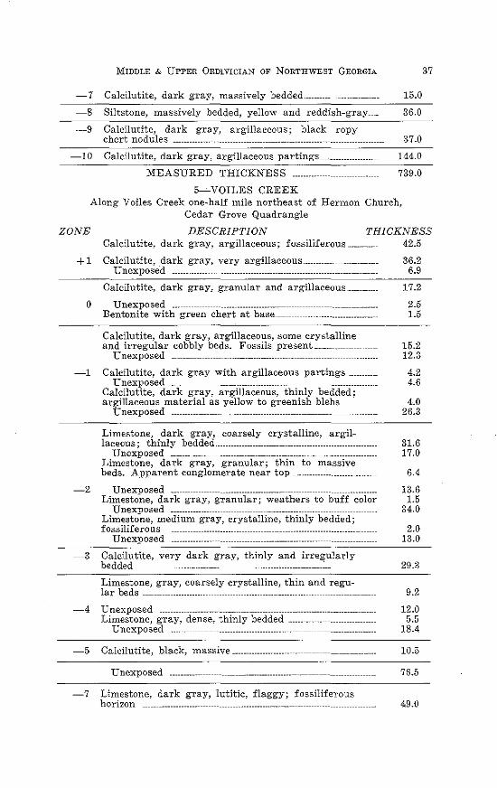
MIDDLE & UPPER 0RDIVICIAN OF NORTHWEST GEORGIA
-7 Calcilutite, dark gray, massively bedded .. ----------------------_ 15.0
~8 Siltstone, massively bedded, yellow and reddish-gray 36.0
-9 Calcilutite, dark gray, argillaceous; black ropy chert nodules -------------------------------------------------------- 37.0
-10 Calcilutite, dark gray, argillaceous partings-------·--·--·------- 144.0
MEASURED THICKNESS ............................. . 739.0
5~VOILES CREEK Along Voiles Creek one-half mile northeast of Hermon Church,
Cedar Grove Quadrangle
37
ZONE DESCRIPTION THICKNESS Calcilutite, dark gray, argillaceous; fossiliferous·----------- 42.5
+ 1 Calcilutite, .dark gray, very argillaceous --------------------------- 36.2
0
Unexposed -------------- ---------------------------------------------------- 6.9
Calcilutite, dark gray, granular and argillaceous____________ 17.2
Unexposed ___ --------------------·---------------- -----------------------------------Bentonite with green chert at base __
Calcilutite, dark gray, argillaceous, some crystalline
2.5 1.5
and irregular cobbly beds. Fossils present·---------- 15.2 Unexposed _______ -------------------------------- __ ------------------------------- 12.3
-1 Calcilutite, dark gray with argillaceous partings _ 4.2 4.6 Unexposed ___ -----------------------------------------
Calcilutite, dark gray, argillaceous, thinly bedded; argillaceous material as yellow to greenish blebs _
Unexposed __ --------------------------------------
Limestone, dark gray, coarsely crystalline, argil-
4.0 26.3
laceous; thinly bedded .. ____________ --------------------------------------- 31.6 Unexposed ------------- ------------------------------------------------ 17.0
Limestone, dark gray, granular; thin to massive beds. Apparent conglomerate near top-------·--··-----·--·---------- 6.4
-2 Unexposed ____ --------------------·-·-··---··------- 13.6 Limestone, dark gray, granular; weathers to buff color 1.5
Unexposed ------·------- -------------------------·-·----- ______ 34.0 Limestone, medium gray, crystalline, thinly bedded; fossiliferous ---------------·---------- -------------------·---··--·--··--·--·------ 2.0
Unexposed ---------·----- ---------------------------·------------ 13.0
-3 Calcilutite, very dark gray, thinly and irre~ularly bedded ········---·-------··--·- -·---·-·-·----------------··-----------·- 29.3
Limestone, gray, coarsely crystalline, thin and regu-lar beds ---------------·---··--- ---------------------------·----·------- 9.2
-4 Unexposed _________ ----·-··--·------- ----------------------··-··----···-·--··-·---- 12.0 Limestone, gray, dense, thinly bedded 5.5
Unexposed _____ -------·--··--······--- ---------------------·-------- 18.4
-5 Calcilutite, black, massive---··--··--·---------------------------------------·- 10.5
Unexposed ·-··-------- ---------------·---··--····--·----- 76.5
-7 Limestone, dark gray, lutitic, flaggy; fossiliferous horizon ----------·--·------ ----------------·-··---···--------- 49.0
38 GEORGIA GEOLOGICAL SURVEY BULLETIN 66
Unexposed ---------------- ------------------ ----------------------- ---------------- 37.4
-8 Limestone, dark gray, coarsely crystalline, thinly bedded; very fossiliferous ______________________________ ---------------- 24.0 Calcilutite, dark gray with small chert nodules________________ 0.5 Limestone, dark gray, coarsely crystalline _______ ---------------- 0.5
-9 Limestone, dark gTay, granular; scattered calcite eyes. Black ropy chert nodules.--------------------- ------------------ 11.5
Calcilutite, dark gray, dense, thinly bedded. Few fossils. Mud cracks abundant ________ ~ ___ : ____ ----------------------------- 9.6
-10 . Unexposed ---------------- ---------------------------------------------------------- 23.7 Calcilutite, dark gray, dense, massive_------------------------------ 3.1
MEASURED THICKNESS ······----- ----········-··---
6-HOG JOWL CREEK
613.2
Along Hog Jowl Creek, one-half mile southwest of McLemore Cove Road, Cedar Grove Quadrangle
ZONE +6
DESCRIPTION THICKNESS Calcilutite, buff, lirgillaceous, poorly exposed____________________ 6.0 Limestone, dark gray, crystalline; fossiliferous________________ 45.0
Calcilutite, dark gray, argillaceous, thinly laminat..: + 5 ed; alternately banded with siltstone. Dark gray
crystalline limestone at base ________________________ -------------------- 48.6
+4 Limestone, dark gray, finely crystalline; fossiliferous____ 17.0
Unexposed -------------------------------------- -------------------------------
Bentonite with green chert at base; green chert at 0 top. Poorly exposed outcrops of light to dark gray
144.0
argillaceous calcilutite ------------------- -------------------------------- 19.0
Calcilutite, dark gray with yellowish argillaceous -1 segregations; massive beds; occasional coarsely
crystalline bed --------------- --------------------------------------------------- 31.0
MEASURED THICKNESS ·······----··········- 310.6
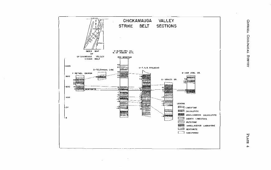
CHICKAMAUGA STRIKE BELT
" CHICKAMAUGA VALLEY STRIKE BELT
1000
2-TELEP~O/IE LINE
1- BETHEL
'"
VALLEY SECTIONS
LEGEND
~ liMESTONE
~ CALCILUTITE
liiB!l ARGILLACEOUS CALCILUTITE
~ ~ -E03
=
CHERTY LIMESTONE
SILTSTONE
ARBILLAOEOUS LIMESTONE
BENTONITE
UNEXPOSED
40 GEORGIA GEOLOGICAL SURVEY BULLETIN 66
CHATTANOOGA VALLEY STRIKE BELT SECTIONS
1-MILL BRANCH Along Mill Branch west of Chattanooga Valley Road, Kensington
Quadrangle
ZONE DESCRIPTION THICKNESS 20.0
+5
+4 +3
+2
Limestone, greenish cast, crystalline textm·e ---------
Unexposed -------------- ---------------------------- -------------------------------Calcilutite, yellow and blue alternating laminations, more apparent on weathered surfaces ------- ________________ ., _____ _
Calcilutite, dark gray, dense, massive----------------------
Calcilutite, dark gray, slightly crystalline ___ _ Calcilutite, dark gray, argillaceous and fossiliferous _______ _
Calcilutite, black, argillaceous --------------- -----------------------------
42.0
10.2
49.5
3.7 10.5
32.0
+ 1 Calcilutite, dark gray, highly a1·gillaceous; shows cobbly weathering --------------------------- ------------------------- 51.0
Calcilutite, medium dark gray, argillaceous; abun-dant mud cracks present in some layers --------- ------------------ 3.0
0 Unexposed -------------------------------------------------------------------------- 2.4 Bentonitic clay ---------------------------------------- -------------------------------- 2. 0 Chert, green, weathers brown; brachiopod impres-sions on upper surface __ --------------------- ----------------------------- 0.5
Calcilutite, dark gray, dense with green argillaceous -1 pa1·tings. Few scattered chert nodules near top 7.5
Unexposed ------------- ------------------------- --------------------- 50.0
Unexposed ------------------------------------------------ --------------------------- 30.0 Limestone, dark gray, crystalline, thinly bedded.
-2 Fossils abundant ---------------------------- __ -------------- --------------------- 15.0 Calcilutite, dark gray, hig·hly argillaceous ______ -------------- 43.5 Calcilutite, dark gray, crystalline. Fossil horizon_ 45.5
-3 Limestone, lutitic, dark gray, crystalline _____ --------------------- 13.0
Limestone, dark gray, crystalline alternating with -4 gray calcilutites ------------- ----------------------- ----------------------- _ 49.0
Limestone, dark gray, coarsely crystalline, massive_ 3.7
-5 Calcilutite, dark brown with large calcite <~eyes"-------------- 11.2
Poorly exposed section __________ ----------------- ------------------------ 30.0
-6 Limestone, dark gray, coarsely crystalline. Some dark gray, fine-grained calcilutite-------------------------------------- 22.5
Calcilutite, light gray, argillaceous; highly weathered Hfossil hash" near top with some secondary
-7 chert. Weathers to a resistant yellow siltstone----------- 31.0 Calcilutite, very dark gray, highly argillaceous________________ 6.8
MEASURED THICKNESS ........ ·········-············· 358.7
MIDDLE & UPPER 0RDIVICIAN OF NORTHWEST GEORGIA 41
2-COOPER HEIGHTS QUARRY One and one-half miles north of Cooper Heights and 1000 feet
west of Georgia Highway 193, Durham Quadrangle
ZONE
+5 DESCRIPTION THICKNESS
Calcilutite, dark gray, thinly laminated argillaceous______ 26.6
Calcilutite, dark gray; crystalline limestone beds about 4 inches thick. Fossil horizon _______________ _ 5.7
+4 Calcilutite, dark gray with thin shale seams; scat~ tered bryozoan horizons_________________________________________ 12.2 Limestone, gray, mottled, crystalline; fossiliferous 12.0 Limestone, dark gray to black, coarsely crystalline with fossiliferous thinly bedded, argillaceous layers ___ 31.5
+ 3, + 2 Calcilutite, dark gray, thinly laminated, argillaceous 22.6
Limestone, medium gray, finely crystalline, massive~ ly bedded ------------------------------ 10.0
+1 Unexposed -----------··········--····-··-----------~-------------------------- 7.0 Calcilutite, light gray, dense____________________________________ 1.5
0 Bentonite, yellowish with green chert showing brachiopod impressions at base______________________________________ 4.7
-1 Calcilutite, dark gray, argillaceous with an occa-sional crystalline layer with fossil debris________________ 52.6
Calcilutite, light gray, dense, massive beds, slightly argillaceous _ -------------------------------------------------------------------- 10.2 Calcilutite, dark gray, dense, massively bedded__ 11.7
Poorly exposed --------------- ----------------------------···--------------··-··-· 48.0
-2 Limestone, dark gray, coarsely crystalline. Fossil horizon ---------------------------------------- _ ----------------------------------------·· 6.4
Unexposed ____ --------------------------------------------------------------------. 6.4 Calcilutite, black, dense, poorly exposed_______ 30.4 Calcilutite, black, dense, argillaceous with some secondary chert -·-···--------------------·--· ----------------------------------·--·· 33.0
MEASURED THICKNESS
3-COOPER HEIGHTS NO. 2 One~fourth mile north of Cooper Heights, east~west ac:::-oss
Georgia Highway 193, Durh~m Quadrangle
332.5
ZONE DESCRIPTION THICKNESS Limestone, dark gray, finely crystalline; minute
+ 1 fossil fragments -----·-··· ·----··--·-··-····--···---------- 43.0 Limestone, dark gray; fossiliferous ----------------------·--·-···--·-·
Calci1utite, light gray to greenish-gray, argillaceous, scattered mud cracks. Some dense layers with cal-
0 cite "eyes". Reddish mottling variable along strike.
Upper green chert layer 3 inches thick at top. Lower green chert at base. Bentonite normally associated with chert not exposed---------------------------------··-
Calcilutite, light gray with scattered green argillaceous segregations. Abundant crinoidal remains, scattered brachiopod fragments -------------------------
19.4
11.0
36.8
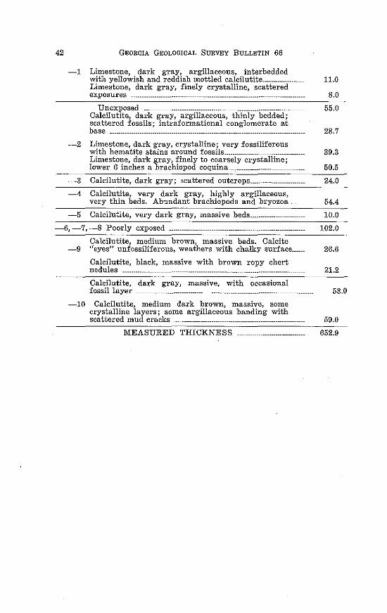
42 GEORGIA GEOLOGICAL SURVEY BULLETIN 66
-1 Limestone, dark gray, argillaceous, interbedded with yellowish and reddish mottled calcilutite___________________ 11.0 Limestone, dark gray, finely crystalline, scattered exposures --------------------------- ------------------------------------ --------------- 8.0
Unexposed __ ------------------------------------------------------------------- 55.0 Calcilutite, dark gray, argillaceous, thinly bedded; scattered fossils; intraformational conglomerate at base __ -------------------------------------- ----------------------------- 28.7
-2 Limestone, dark gray, crystalline; very fossiliferous with hematite stains around fossils___________ ---------------------- 39.3 Limestone, dark gray, finely to coarsely crystalline; lower 6 inches a brachiopod coquina___________________ 50.5
-3 Calcilutite, dark gray; scattered outcrops_______________________ 24.0
-4 Calcilutite, very dark gray, highly argillaceous, very thin beds. Abundant brachiopods and bryozoa______ 54.4
-5 Calcilutite, very dark gray, massive beds___________________ 10.0
-6, -7,-8 Poorly exposed ---------------------------------------------------------- 102.0
Calcilutite, medimu' brown, massive beds. Calcite -9 "eyes" unfossiliferous, weathers with chalky surface______ 26.6
Calcilutite, black, massive with brown ropy chert nodules ----------------
Calcilutite, dark gray, massive, with occasional fossil layer _______ --------------------- -------------------------- ----------------
-10 Calcilutite, medium dark brown, massive, some crystalline layers; some argillaceous banding with
21.2
53.0
scattered mud cracks -------------------- ------------------------------- 59.0
MEASURED THICKNESS 652.9
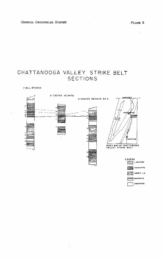
GEORGIA GEOLOGICAL SURVEY PLATE 5
CHAT TAN 0 0 G A VALLEY STRIKE BELT SECTIONS
I-MILL BRANCH
2~ COOPER HEIGHT$
3~ COOPER HEIGHTS NO.2
INDEX MAP OF CHATTANOOGA VAL.LEY STRIKE BELT
LEGEND
~t.1.UTCU
m ;At.Cit.UTITE
~ CHEOTT 1..1.
E:3 UNTOMITE
D UNU~OIED
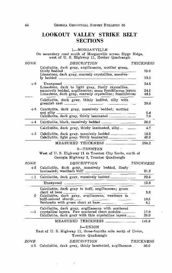
44 GEORGIA GEOLOGICAL SURVEY BULLETIN 66
LOOKOUT VALLEY STRIKE BELT SECTIONS
1-MORGANVILLE On secondary road south of Morganville across Slygo Ridge,
west of U. S. Highway 11, Hooker Quadrangle
ZONE DESCRIPTION THICKNESS Calcilutite, dark gray, argillaceous, mottled green, thinly bedded ---------------------------------------------------------------------------- 19.0 Limestone, dark gray, coarsely crystalline, massive-ly bedded ---------------------------------------------- ·---------------------------------- 18.5
+ 6 Unexposed _---------------------------------------------------------------------------- 34.5 Limestone, dark to light gray, finely crystalline, massively bedded, argillaceous; some fossiliferous layers 24.5 Limestone, dark gray, coarsely crystalline; fossiliferous 44.5
Calcilutite, dark gray, thinly bedded, silty with greenish cast --------------- -------------------------------------------------- 20.6
+ 5 Calcilutite, dark gray, massively bedded; mottled and silty ------------------- --------------·· -------------------------------- 6.4 Calcilutite, dark gray, thinly laminated---------------------------- 7.0
+4 Calcilutite, black, massively bedded ----------- ------------------------- 26.0
Calcilutite, dark gray, thinly laminated, silty.... 4.7
+3 Calcilutite, dark gray, massively bedded------------------------ 10.5
ZONE +2
+1
Calcilutite, light gray, thinly laminated ____________ ----------------- 40.0
MEASURED THICKNESS
2-TRENTON West of U.S. Highway 11 in Trenton City limits, north of
Georgia Highway 2, Trenton Quadrangle
256.2
DESCRIPTION THICKNESS Calcilutite, dark gTay, massively bedded, finely laminated; weathers buff ------------------------ ---------------------------- 21.2
Calcilutite, dark gray, massively bedded-------------------------- 32.5
Unexposed ------------------- ------------------------------ ____ ., ______________ _ 13.8
Calcilutite, dark gray to buff, argillaceous; green chert at base -------------- ----------------------------- ------------------- 3.8
0 Calcilutite, dark gray, argillaceous, weathers to buff-colored shards --------- ---------------------------- ---------------------- 10.5 Bentonite with green chert at base------------------------------------ 4.1
Calcilutite, dark gray, argillaceous with scattered -1 crystalline layers. Few scattered chert nodules___________ 17.0
ZONE +5
Calcilutite, dark gray with thin crystalline layers.--------- 39.0
MEASURED THICKNESS ------------------
3-UNION
141.9
East of U. S. Highway 11, three-fourths mile north of Union, Trenton Quadrangle
DESCRIPTION THICKNESS Calcilutite, dark gray, thinly laminated, argillaceous _ 36.0
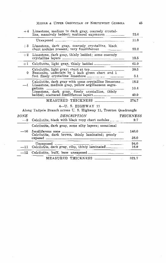
MIDDLE & UPPER 0RDIVICIAN OF NORTHWEST GEORGIA
+ 4 Limestone, medium to dark gray, coarsely crystalline, massively bedded; scattered exposures _
Unexposed
+3 Limestone, dark gray, coarsely crystalline, black chert nodules present; very fossiliferous__ _ -------------------
+2 Limestone, dark gray, thinly bedded; some coarsely crystalline layers ------------- ___________ -----------------------------------··------
+ 1 Calcilutite, light gray, thinly bedded·---------··-------
Calcilutite, light gray; chert at top----------------------------------0 Bentonite, underlain by 1 inch green chert and 1
foot finely crystalline limestone ----------------------
Calcilutite, dark gray with some crystalline limestone __ -1 Limestone, medium gray, yellow argillaceous segre-
gations ------------ ------------------------------ _________ --------------------------------Limestone, dark gray, finely crystalline, thinly bedded; scattered fossiliferous layers·---------------
MEASURED THICKNESS
4-U. S. HIGHWAY 11
23.0
11.8
22.2
18.5
61.0
30.5
3.1
18.2
10.4
40.0
274.7
Along Tadpole Branch across U. S. Highway 11, Trenton Quadrangle
45
ZONE DESCRIPTION THICKNESS -9 Calcilutite, black with black ropy chert nodules___________ 9.7
Calcilutite, dark gray, some silty layers; occasional
-10 fossiliferous zone _____ -------------------------------------------------------------Calcilutite, dark brown, thinly laminated; poorly exposed --------- ------------------------ ----------------------------
Unexposed ________ ---------------------------- ___ ----------------------------------11 Calcilutite, dark gray, silty, thinly laminated ...... ., _______ _
-12 Calcilutite, buff, base unexposed·----------------------------
MEASURED THICKNESS ...... .
146.0
56.0
94.0 16.0
321.7
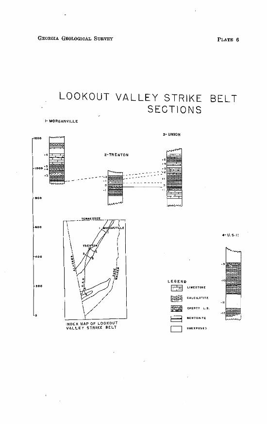
GEORGIA GEOLOGICAL SURVEY
1100
1000
000
'"
.,.
...
LOOKOUT VALLEY STRIKE SECTIONS
1- MORGANVILLE
2·TRENTON
~-- --~U!!ll.......-
\ \ i <,
~· ::
) I i i i ( !
INDEX MAP OF LOOKOUT VALLEY STRIKE BELT
3· UNION
LEGEND
E2l ~
""""' = a D
LlMESTilttE
CA.LCllUTITf.
CtiERTY L.S.
BENTONITt
UNtXPOSEO
PLATE 6
BELT
4-U.S-11
MIDDLE & UPPER 0RDIVICIAN OF NORTHWEST GEORGIA 47
GENERAL DESCRIPTION OF OFFSHORE ZONES
Zone +S
Thickness:
55 to 75 feet in Rabbit Valley; 47 feet in Chickamauga Valley; 30 feet in Chattanooga Valley; and 35 to 43 feet in Lookout Valley.
Description:
This zone can only be measured in two localities in Rabbit Valley and these measurements indicate a distinct thinning from north to south. The lower few feet are composed of light brown silty limestone with an abundance of fossils. Above the fossiliferous layers the zone is poorly exposed. Where present, the exposures are composed of thinly bedded, shaly limestones grading upward into greenish-blue, coarsely crystalline limestones in 1 to 2 inch layers separated by green shale partings.
In Chickamauga Valley the rocks appear as blue, finely crystalline limestones on the surface. However, silt makes up 65 to 75 percent of their composition and ciay is almost completely absent. In this belt the rocks are completely devoid of fossils. The thin, red-colored limy rocks are mostly laminated and often show cross lamination.
The zone presents much the same picture in Chattanooga Valley. It is thinner than in Chickamauga Valley, unfossiliferous and badly weathered. In the unweathered condition the rocks appear as rather pure limestones, but insolubles are almost always higher than 50 percent.
In Lookout Valley, two distinct lithologic types make up the zone. The lower 15 to 20 feet consist of light blue to light green, fine- to medium-grained crystalline, silty limestones with fossils locally abundant. This is overlain by 15 to 20 feet of light blue, calcareous, laminated siltstones. Normally the laminae are parallel, but layers of strongly crossbedded laminae are often present. Beds range from a few inches to 2 feet in thickness. Shale partings are not present between beds but green siltstone pebbles are often noted in the siltstones and limestones.
48 GEORGIA GEOLOGICAL SURVEY BULLETIN 66
Fossils Present in Rabbit Valley:
Bryozoa:
Petogopho?·a sp. P?·asopo?·a hospitalis Nicholson
Brachiopods:
Hebe1·tella f?·ankjo?·tenis Foerste H. sinuata (Hall)
Leptaena sp.
PlatystTophia acutili?·ata (Conrad)
Plecto1·this jissicosta Hall
Fossils Present in Lookout Valley:
Brachiopod:
Platystt;·ophia ponder-osa Foerste
Location of Outcrops:
1) In bed of stream flowing through Parker Gap, Ringgold Quadrangle.
2) In ravines on scarp slope of Taylor Ridge near Ringgold Water Gap, Ringgold Quadrangle.
3) Along roadcut on south side of Georgia Highway 143 on Pigeon Mountain, Kensington Quadrangle.
4) Along old Central of Georgia roadbed near McCallie Lake in the Fort Oglethorpe Quadrangle.
5) In Tadpole Branch, 800 feet east of U. S. Highway 11, Trenton Quadrangle.
6) In Crawfish Creek, 300 feet east of U. S. Highway 11, Trenton Quadrangle.
Zone +,7
Thickness:
90 feet in Rabbit Valley; 26 feet in Chickamauga Valley; 38 feet in Chattanooga Valley; and 24 feet in Lookout Valley.
MIDDLE & UPPER 0RDIVICIAN OF NORTHWEST GEORGIA 49
Description:
The dominant feature of this zone is the presence of red beds. In the eastern belts the lithology is uniform throughout and is composed of massive, fine-grained limestone that, with the exception of a few blue-gray layers, is predominantly reddish-brown or purple in color. A large amount of silt is intermixed with the limestone and on dry weathered surfaces the rock appears to be a red, fine-grained sandstone. Fossils are absent in ail exposures.
The total thickness of the zone as weii as the thickness of the individual beds is much reduced in Chickamauga Vaiiey. The red mudstone layers alternate with beds of limy siltstone none of which exceeds 8 inches in thickness. In some instances the individual layers are only 1/s inch thick.
The lower 1 foot in Chattanooga VaHey consists of a thinly laminated, bluish-gray, limy siltstone. Above this horizon the zone is composed of alternating bands of red and yeiiow mudstone or limestone. The red bands normaiiy are less than 1 inch in thickness, and rarely may be up to 6 inches thick. This zone is seldom exposed in this strike belt, however, when present, it can be easily recognized by its red and yeiiow color, the banding, and the complete absence of fossil remains.
In Lookout VaHey, the zone lies in sharp contact with the massive argiiiaceous limestone of Zone + 6. The lower 5 or 6 feet consists of mottled purple and yeiiow siltstone which contains some clay, fossil fragments, and smaii pieces of limestone from the top of Zone + 6. Overlying this, the remainder consists of alternating bands of purple clay and yeiiow silt.
Location of Outcrops:
1) In bed of stream flowing through Parker Gap, 2400 feet southeast of Parker Gap Church, Ringgold Quadrangle.
2) In the northern end of Taylor Ridge on the south side of the Ringgold Water Gap, Ringgold Quadrangle.
3) On south side of Georgia Highway 143, west side of Pigeon Mountain, Kensington Quadrangle.
4) Along old Central of Georgia Railroad near McCaiiie Lake, Fort Ogethorpe Quadrangle.
50 GEORGIA GEOLOGICAL SURVEY BULLETIN 66
5) Along Lookout Mountain Scenic Highway three-fourths mile west of Cooper Heights, Durham Quadrangle.
6) In roadcut on U. S. Highway 11 at Wildwood, Hooker Quadrangle.
7) Along west side of Taylor Ridge at Maddox Gap, Catlett Quadrangle.
Zone· +6
Thickness:
Only the upper 55 feet is exposed in Rabbit Valley; 150 feet thick in Chickamauga Valley; 136 feet in Chattanooga Valley; and 137 to 157 feet in Lookout Valley.
Description:
The lithology of the zone is uniform throughout its extent but the characteristic fauna make this a very distinctive unit. Throughout its thickness the rocks consist of blue, flaggy, crystalline limestone separated by shale partings which are more obvious on weathered outcrops. The zone is best exposed in the Chickamauga and the Lookout Strike Belts where it can be divided into sub-units. In Rabbit Valley and Chattanooga Valley it is so poorly and incompletely exposed, that only its fauna and general characteristics can be studied.
In Chickamauga Valley, the zone may be divided into a lower unfossiliferous zone 26 feet thick and the upper fossiliferous zone of 124 feet thickness. In Lookout Valley, light green, argillaceous limestone occurs in the upper part of the horizon.
Much of the rock fabric is a reflection of the large quantity of fine fossil debris and well-preserved forms.
Fossils:
Coral:
Tet1'aditvnt fib1·atum Safford
Bryozoa:
Amplexipora columbiana Ulrich & Bassler Ataetoporella sp.
MIDDLE & UPPER 0RDIVICIAN OF NORTHWEST GEORGIA
Callopora andrewsi Nicholson C. dalei (Edwards and Haime) C. ramosa, D'Orbigny C. ramosa va1·. rugosa C. sigillaroides Nicholson C. subnodosa Ulrich Constellaria sp. C. prominens Ulrich Dekaye'lla ulrichi Nicholson Dekayia aspera Edwards & Haime E'ridotrypa sp. E. mutabilis Ulrich Escharopora falciformis (Nicholson) Hallopora dalei (Edwards & Haime) H eterotrypa frondosa ? H. parvulipora Ulrich & Bassler H omotrypa sp. H. cincinnatien.sis Bassler H. curvata Ulrich H. cylindrica Bassler H. flabellaris Bassler H. grandis Bassler H. obliqua Ulrich Leptotrypa clavis Ulrich M onot1·ypa in tabulata. Winchell & Ulrich Petigophura sp. Prasopora sp.
Brachiopods:
H ebertella borealis Hall & Clarke ? H. frankfortensis Foerste H. occidentalis Hall H. sin~wta (Hall) 01"thorhyncula linneyi (James) Platystrophia crassa James P. colbiensis '? P. colbiensis mutata ? P. elegantula ? P. juvensis ? P. laticosta (Meek) P. pondm·osa Foerste P. precu.rsor Foerste P. strigosa ? P. sublaticosa (Meek) Plectorth•:.S fissicosta Hall P. plicatella (Hall) Rafinesquina alternata (Emmons) Rhynchotrema capax (Conrad) Zygospira sp.
51
52 GEORGIA GEOLOGICAL SURVEY BULLETIN 66
Z. modesta Say Z. recU'rvi·rost·ris (Hall)
Pelecypods:
Byssonchia sp. B. intm·media (Meek & Worthen)
Gastropods:
H onnotoma sp. Liospi1·a sp. Lophospira bowdeni ?
Cephalopods:
Aug~tstoceras sp. Cyrtoceras sp. C. va-llandinghami ? Michelinoceras sp. Valcouroce·ras sp.
Trilobite:
Flexicalymene sp.
Location of Outcrops:
1) Along telephone line, 1000 feet north of Georgia Highway 143, Kensington Quadrangle.
2) Along south side of Georgia Highway 143, west of Pigeon Mountain, Kensington Quadrangle.
3) 300 feet east of Georgia Highway 193 at Haysville, Fort Oglethorpe Quadrangle.
4) Along Powder Mill Branch east of McCallie Lake in the Fort Oglethorpe Quadrangle.
5) In quarry east of Morganville, Hooker Quadrangle.
6) Roadcnts of U. S. Highway 11 between Wildwood and Morganville, Hooker Quadrangle.
Zone +5
Thickness:
Zone is unexposed m Rabbit Valley; 52 feet in Chicka-
MIDDLE & UPPER 0RDIVICIAN OF NORTHWEST GEORGIA 53
mauga Valley; 61 to 73 feet in Chattanooga Valley; and 42 to 75 feet thick in Lookout Valley.
Description:
The lithologic features of this zone are normally persistent throughout the entire area and show only minor variations. It does not differ appreciably from the lower laminated rocks of Zone +3. The bedding is more massive and tends to break along the numerous clay laminae. The clay content is higher and consequently there are more yellow layers than blue. Like Zone +3, the blue layers are silty limestones and the yellow layers are argillaceous limestones. Near the middle of the zone in Lookout Valley a light blue to light green, banded limestone occurs. In most areas the upper contact is unexposed but where it is seen the zone grades into Zone + 6 by a decrease in the thickness of the silty layers and a corresponding increase in the blue limestone layers. Fossils become more plentiful near the top of the zone with the decrease in silt. The fauna is represented by fragments of brachiopods and an occasional unidentifiable bryozoan.
Locations of Outcrops:
1) Along telephone line, 1000 feet north of Georgia Highway 143, Kensington Quadrangle.
2) Along Georgia Highway 143, west of Pigeon Mountain, Kensington Quadrangle.
3) On Tennessee, Alabama, and Georgia Railroad, 1500 feet east of McLemore Cove Road, Kensington Quadrangle.
4) 600 feet west of Georgia Highway 193 at Haysville in the Fort Oglethorpe Quadrangle.
5) Along Powder Mill Branch one-half mile east of McCallie Lake in the Fort Oglethorpe Quadrangle.
6) Along secondary road 1500 feet west of U. S. Highway 11 at Morganville, Hooker Quadrangle.
Zone +4
Thickness:
Unexposed in Rabbit Valley; 7 feet thick in Chickamauga
54 GEORGIA GEOLOGICAL SURVEY BULLETIN 66
Valley; 9 feet in Chattanooga Valley; 9 feet in Lookout Valley.
Description:
This zone, because of the abundant fossils present and its distinctive lithology, is separated from the underlying and overlying laminated limestones. In Chickamauga Belt exposures of the rocks are black; lutitic to finely crystalline limestone. On the weathered surfaces the beds are massive and blue in color. Fossils are rare in sections but appear abundantly on weathered surfaces because the rock is crumbly and disintegrates more rapidly than the fossils.
The zone is slightly thicker in the Chattanooga Valley Belt but the fauna is less abundant and poorly preserved. Typically the rocks consist of blue-gray, finely crystalline to lutitic limestone with irregular argillaceous bands.
The zone has remarkable persistence in lithology, thickness, and faunal content throughout the area and appears much the same in Lookout Valley as it does in the strike belts to the east. Since the rocks above and below weather so rapidly, this zone appears as thick slabs which lie scattered at random on the surface.
The upper and lower contacts are not well-defined and the zone grades upward and downward into the laminated rocks of Zone +5 and Zone +3 respectively.
Fossils:
Bryozoa:
Batostoma magnapo'l"a ? CaUopora dumalis Ulrich C. goodkuensis Ulrich Constella1-ia sp. Dekayella sp. Eridot·rypa sp. HMnot·rypa curvata var. praecipta Bassler Rhinidictya sp.
Brachiopods :
Hebm·tella sp. H. borea.lis (Billings) H. frankfortensis Foerste H. occidentalis Hall
MIDDLE & UPPER 0RDIVICIAN OF NORTHWEST GEORGIA 55
Rhynchotrema increbescens (Hall) Zygospi1·a 1·ecur'Virostris (Hall)
Gastropods :
LiospiTa sp. Lophospira sp.
Cephalopod:
Orthoce1·as sp.
Location of Outcrops:
1) In bank of stream along telephone line, 1000 feet north of Georgia Highway 143, Kensington Quadrangle.
2) Along Tennessee, Alabama, and Georgia Railroad, 1500 feet east of McLemore Cove Road, Kensington Quadrangle.
3) 600 feet west of Georgia Highway 193 at Haysville in the Fort Oglethorpe Quadrangle.
4) Along Powder Mill Branch one-half mile east of McCallie Lake in the Fort Oglethorpe Quadrangle.
5) Along Mill Creek, just west of Georgia Highway 193, northwest Kensington Quadrangle.
6) Along secondary road, 1000 feet west of U. S. Highway 11 at Morganville, Hooker Quadrangle.
7) Along Southern Railroad seven-tenths mile south of Georgia Highway 2 overpass, Trenton Quadrangle.
Zone +3
Thickness:
Unexposed in Rabbit Valley; 40 feet thick in Chickamauga Valley; 33 feet thick in Chattanooga Valley; 119 feet thick in Lookout Valley.
Description:
Throughout the entire thickness of this zone in Chickamauga Valley and Chattanooga Valley, the rocks are thinly laminated except for an occasional thicker band of finegrained limestone or dark-gray calcilutite. The greater part
56 GEORGIA GEOLOGICAL SURVEY BULLETIN 66
of the unit consists of alternations of thin, yellow argillaceous laminae and bluish-gray calcareous laminae less than 1 mm. in thickness. The argillaceous laminae average 0.37 mm. and the calcareous laminae average 0.52 mm. Normally the argillaceous lamina initiates each couplet and grades upward into the calcareous lamina, which is separated from the next overlying layer by a sharp, well-defined boundary.
Generally the laminations are persistent laterally with little variation in thickness, however, occasionally they are interrupted by intraformational conglomerates and breccias.
In LookotJt Valley, the lithology of the zone is different in part and quite variable in thickness. The thickness of the lower unit varies from 14 feet in the north, to 25 fe-et in the middle and to 5 feet in the extreme southern part of the strike belt.
This lower member consists of bands of dark blue, finegrained, silty limestones, 112 inch to 1 foot in thickness, separated by yellow, argillaceous laminae a few millimeters in thickness.
Unit 2 of Zone + 3 in this strike belt shows a decrease in thickness from 62 feet in the north to 38 feet in the southern part. In contrast to the thinning in the south is the rapid thickening to the west. The thickness is 88 feet in the westernmost exposure. The lithology is constant throughout and consists of alternating beds of black calcilutite and fine to coarsely crystalline limestone. The beds range from 1 inch to 1 foot in thickness and lie in sharp contact with one another. Although the lithology is constant the faunal elements are highly variable. This unit has no correlations in the eastern strike belts and seems to represent a local change in depositional environment.
Unit 3 is essentially a repetition of Unit 1. Laminae begin to appear immediately above the contact and continue upward to the middle of the zone. On weathering the argillaceous laminae are yellow and contrast sharply with the blue, finegrained limestone layers. These laminae are more numerous and continuous than those in Unit 1. Mud cracks and ripple marks occur frequently.
Near the middle of the zone a 7 foot unit of lutitic and fine-
MIDDLE & UPPER 0RDIVICIAN OF NORTHWEST GEORGIA 57
grained limestone is present. The distinctive feature is the black chert nodules which rarely exceed 3 inches in diameter. Above the middle unit laminated limestones appear. Silt and fine-grained sand increase upward, and as a result the rocks of the upper part weather easily and are poorly exposed. The rocks of this unit are gray to light brown, and often contain green clay pebbles. Laminae are crossbedded, crumbled, and broken.
Fossils:
Sponges:
Stromatoeerium pustulosum Safford
Corals:
Tetradium eellulosum (Hall) T. fibratum Safford
Brachiopods :
Hebe'rtella frankfortensis Foerste H. oecidentalis Hall Platystrophia trentonensis McEwan
Gastropod:
H ormotoma sp.
Pelecypod:
Byssonchia cf. B. inte1·media (Meek & Worthen)
Ostracods:
Isochilina nelsoni Jones ? Leperditilk fabulites (Conrad)
Location of Outcrops:
1) One mile east of Old Bethel Church, Kensington Quadrangle.
2) South side of Georgia Highway 143, one mile west of Pigeon Mountain, Kensington Quadrangle.
3) In quarry, one and one-half miles north of Cooper Heights in the Durham Quadrangle.
58 GEORGIA GEOLOGICAL SURVEY BULLETIN 66
Zone +2
Thickness:
In Rabbit Valley about 30 feet since the top is unexposed and complete thickness cannot be determined; 20 feet in Chickamauga Valley; 39 feet in Chattanooga Valley; and 20 to 40 feet in Lookout Valley.
Description:
Tetradium fibratum is a principal constituent of the rock in all areas of outcrops and therefore the zone is easily recognizable and useful as a marker horizon in correlation.
In Rabbit Valley, the easternmost belt of exposure, the lower few feet of the unit are composed of massive 1 to 2 foot layers of bluish-gray, coarsely crystalline limestone. The remainder of the zone exposed is made up of dark, finegrained limestone and dark gray calcilutite. The fine-grained horizons contain many large colonies of Tetradium fibratum. On many outcrops the coral colonies are 1 to 2 feet in diameter and cover most of the outcrop surface.
In Chickamauge Valley, the zone is thinner and the limestone is massive, dark gray, and finely crystalline. Tetradium is equally abundant here. The zone thickens westward to 39 feet in Lookout Valley. Here the lower few feet are gray, coarsely crystalline limestone which rests in sharp contrast on the underlying fine-grained to lutitic limestone. The crystalline layers grade upward into black calcilutite 4 feet above the contact and the remainder of the zone consists of black, fine-grained limestone. In this unit Tetradium fibratum occurs in profusion. Other fossil species also occur but are of. minor importance. ·
In Lookout Valley, the lower limit is not as well-defined as in the strike belts to the east because Tetradium is also present in the underlying zone and becomes progressively more abundant until it predominates the fauna. The limestone is dark gray, finely crystalline, and massively bedded. In many instances the spaces between the colonies are filled with fragments of Tetradium corallites.
Overlying the coral biostrome in this strike belt are thin layers of dark brown, medium-grained sandstone which con-
MIDDLE & UPPER 0RDIVICIAN OF NORTHWEST GEORGIA 59
tain angular quartz grains, quartz shards, and volcanic glass fragments. Its presence would indicate the previous existence of a metabentonite layer.
The top 5 feet of light brown, argillaceous limestone carries an abundance of bryozoa.
The occurrence of the Tetradium biostrome may represent the time equivalence of this horizon in all areas of outcrop but it certainly represents an environment in which pure limestone was being deposited. A trend from high silt content in 0 Zone to less silt in Zone + 1, to still less in Zone +2 is quite pronounced.
Fossils:
Coral:
Tetradit!m fibTatum Safford
Bryozoa:
Batostoma minnesotense Ulrich B. va1·u'm ? B. winchelli Ulrich Callopora multitabulata. (Ulrich) Pachydic-tya folia.ta Ulrich Rhynidictya mutabilis Ulrich
Brachiopod:
Chaetetes sp. Rhync:hotrema sp. R. argentu1·biem (White)
Gastropod:
H ormotoma sp. Lophospira sp.
Ostracods:
Isochilina sp. Leperditia sp.
Location of Outcrops:
1) 1900 to 2000 feet east of Georgia Highway 151, one and one-half miles north of Ringgold, Ringgold Quadrangle.
60 GEORGIA GEOLOGICAL SURVEY BULLETIN 66
2) One mile east of Old Bethel Church, Kensington Quadrangle.
3) South side of Georgia Highway 143, one mile west of Pigeon Mountain, Kensington Quadrangle.
4) In quarry one and one-half miles north of Cooper Heights in the Durham Quadrangle.
5) One-fourth mile north of Cooper Heights Cemetery, Durham Quadrangle.
6) Along Rising Fawn-Amos Mill Road one and one-half miles south of Rising Fawn, Sulphur Springs Quadrangle.
7) 100 feet east of the intersection of the Sulphur Springs Gap Road and the Southern Railroad, Sulphur Springs Quadrangle.
Zone +I
Thickness:
The thickness of Zone +1 is 139 feet in Rabbit Valley; 82 feet in Chickamauga Valley; 66 feet in Chattanooga Valley; and 58 feet in Lookout Valley.
Description:
This zone can be subdivided into two units in most areas of outcrop but for the sake of convenience it is considered as one. Although Rhynchotrema sp. occur scattered throughout many zones, they are more abundant in this zone than any other and hence reference is made to this as the "Rhynchotrema Zone".
In Rabbit Valley the rock in the lower part is a gray to dark gray, fine- to medium-grained, fossiliferous limestone. The beds are thin, irregular layers 1 to 3 inches thick separated by silt layers up to lf2 inch thick.
The upper 44 feet in Rabbit Valley are composed of brown, fine-grained argillaceous limestone, blue-gray, medium-grained crystalline limestone, and a light-brown siltstone. The argillaceous material is intermixed in the rock rather than occurring along the bedding planes as in the lower part.
l\IIIDDLE & UPPER 0RDIVICIAN OF NORTHWEST GEORGIA 61
The presence of Rhynchotrema increbescens in large numbers in the lower horizons of the upper unit make it easily recognizable and therefore a useful "key bed". In Chickamauga Valley, the lower unit is characterized by massively bedded, medium gray limestone and abundant Rhychotrema increbescens.
The overlying unit is composed of black calcilutite with intermittent shale layers.
In Chattanooga Valley the lower unit is 35 feet thick and generally composed of a rather nondescript dark gray, finegrained limestone. Normally it is poorly exposed in this strike belt but locally Rhynchotrema increbescens is common.
The upper unit is composed of light gray, thick crystalline limestone layers separated by thin argillaceous layers. Fossils are abundant and well-preserved in this unit.
The lower unit is quite thin in Lookout Valley and averages about 10 feet. Outcrops are poor and widely scattered. Alternating layers of light gray and light green, lutitic and mediumgrained limestone occur.
The upper unit thins from 52 feet to 16 feet from north to south along the strike. In general the unit is composed of medium gray, fine- to medium-grained crystalline limestone. Impurities are confined mosty to argillaceous partings. Rhynchotrema increbescens occurs in large numbers in the weathered outcrops.
The percentage of silt in the zone decreases upward in all strike belts. The layer of most prolific Rhynchotrema occurs in the upper unit in Rabbit Valley, Chattanooga Valley, and Lookout Valley but is present in the lower unit in Chattanooga Valley. Also attention should be directed to the westward thinning the zone.
The upper boundary of the zone is less well-defined in the westernmost belt than in the other strike belts.
Fossils:
Sponges:
Stromatocerium sp.

62 GEORGIA GEOLOGICAL. SURVEY BULLETIN 66
S. pustolosum Safford S. rugosum Hall
Corals:·
St1·eptelasma sp. Tetradium fibratum Safford
Bryozoa:
Batostoma implicatum Nicholson B. minnesotense Ulrich Eridotrypa sp. H omot?-ypa sp. H. subntmosa Ulrich Pachydictya foliata Ulrich Rhinidictya sp. R. mt~tabilis Ulrich
Brachiopods:
A rchaeorthis (?) sp. Fascifera subca·rinata Ulrich & Cooper Hebet·tella sp. H. bo·realis (Billings) Rafinesquina t-rentonensis Conrad Rhynchot-;·ema sp. R. argenturbiem (White) R. increbescens (Hall) Zygospi•ra modesta Say
Gastropods:
H o1·motoma g1·acilis (Hall) Lophospira sp.
Cephalopod:
Orthoceras sp.
Ostracod:
Lepe1·ditia sp.
Location of Outcrops:
1) 1500 to 1900 feet east of Georgia Highway 151, one and one-half miles north of Ringgold, Ringgold Quadrangle.
2) In quarry one and one-half miles north of Cooper Heights in the Durham Quadrangle.
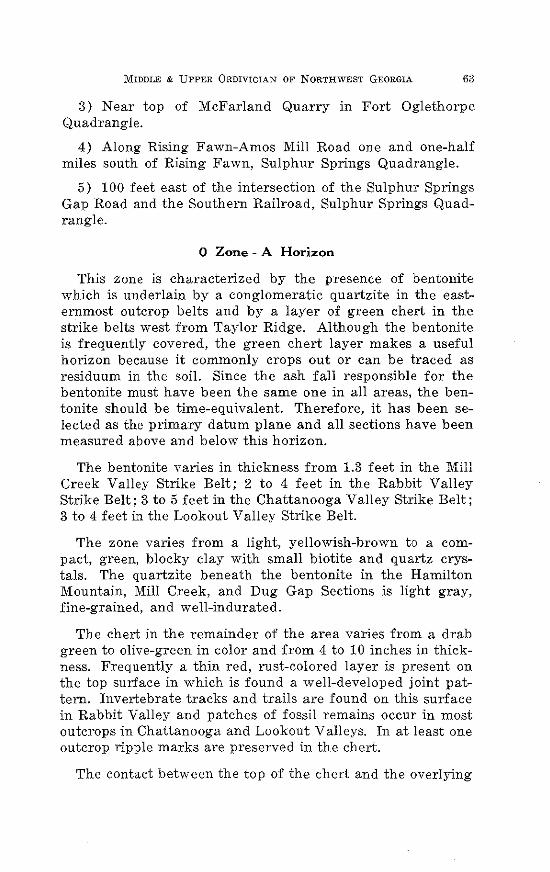
MIDDLE & UPPER 0RDIVICIAN OF NORTHWEST GEORGIA 63
3) Near top of McFarland Quarry in Fort Oglethorpe Quadrangle.
4) Along Rising Fawn-Amos Miii Road one and one-half miles south of Rising Fawn, Sulphur Springs Quadrangle.
5) 100 feet east of the intersection of the Sulphur Springs Gap Road and the Southern Railroad, Sulphur Springs Quadrangle.
0 Zone - A Horizon
This zone is characterized by the presence of bentonite which is underlain by a conglomeratic quartzite in the easternmost outcrop belts and by a layer of green chert in the strike belts west from Taylor Ridge. Although the bentonite is frequently covered, the green chert layer makes a useful horizon because it commonly crops out or can be traced as residuum in the soil. Since the ash fail responsible for the bentonite must have been the same one in ail areas, the bentonite should be time-equivalent. Therefore, it has been selected as the primary datum plane and ail sections have been measured above and below this horizon.
The bentonite varies in thickness from 1.3 feet in the Mill Creek Vaiiey Strike Belt; 2 to 4 feet in the Rabbit Vaiiey Strike Belt; 3 to 5 feet in the Chattanooga Vaiiey Strike Belt; 3 to 4 feet in the Lookout V ailey Strike Belt.
The zone varies from a light, yeiiowish-brown to a compact, green, blocky clay with smaii biotite and quartz crystals. The quartzite beneath the bentonite in the Hamilton Mountain, Miii Creek, and Dug Gap Sections is light gray, fine-grained, and weii-indurated.
The chert in the remainder of the area varies from a drab green to olive-green in color and from 4 to 10 inches in thickness. Frequently a thin red, rust-colored layer is present on the top surface in which is found a weii-developed joint pattern. Invertebrate tracks and trails are found on this surface in Rabbit Vaiiey and patches of fossil remains occur in most outcrops in Chattanooga and Lookout Vaiieys. In at least one outcrop ripple marks are preserved in the chert.
The contact between the top of the chert and the overlying
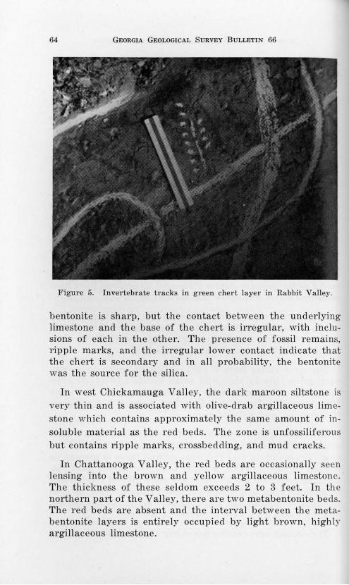
64 GEORGIA GEOLOGICAL SURVEY BULLETIN 66
Figure 5. Invertebrate tracks in green chert layer in Rabbit Valley.
bentonite is sharp, but the contact between the und erlying limestone and the base of the chert is irregular, with inclusions of each in the other. The presence of fossil remains, ripple marks, and the irregular lower contact indicate that the chert is secondary and in all probability, the bentonite was the source for the silica.
In west Chickamauga Valley, the dark maroon siltstone is very thin and is associated with olive-drab argillaceous limestone which contains approximately the same amount of insoluble material as the red beds. The zone is unfossiliferous but contains ripple marks, crossbedding, and mud cracks.
In Chattanooga Valley, the red beds are occasionally seen lensing into the brown and yellow argillaceous limestone. The thickness of these seldom exceeds 2 to 3 feet. In the northern part of the Valley, there are two metabentonite beds. The red beds are absent and the interval between the metabentonite layers is entirely occupied by light brown, highly argillaceous limestone.
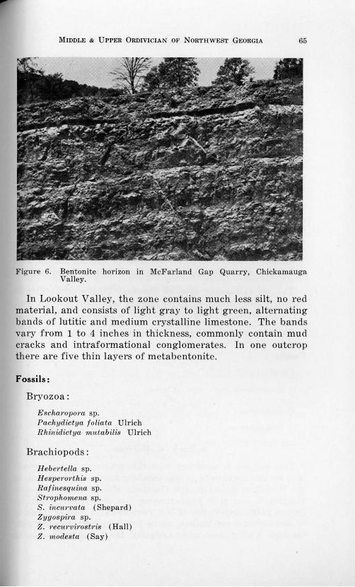
MIDDLE & UPPER 0RDIVICIAN OF NORTHWEST GEORGIA 65
Figure 6. Bentonite horizon in McFarland Gap Quarry, Chickamauga Valley.
In Lookout Valley, the zone contains much less silt, no red material, and consists of light gray to light green, alternating bands of lutitic and medium crystalline limestone. The bands vary from 1 to 4 inches in thickness, commonly contain mud cracks and intraformational conglomerates. In one outcrop there are five thin layers of metabentonite.
Fossils:
Bryozoa:
Escha?·opo?·a sp. Pachydictya foliata Ulrich Rhinidictya ?nutabilis Ulrich
Brachiopods:
H ebm·tella sp. H espm·orthis sp. Rafinesquina sp. St?·ophomena sp. S. incu?·vata (Shepard) Zygospim sp. z. ?·ecurvi?·ost?·is (Hall) z. modesta (Say)
66 GEORGIA GEOLOGICAL SURVEY BULLETIN 66
0 Zone - B Horizon
This is one of the most variable zones in the entire Ordovician Section both in thickness and lithology. It is 13 feet thick at Hassler's Mill; 28 to 45 feet thick in Rabbit Valley; 12 to 15 feet thick in west Chickamauga Valley; about 25 feet thick in Chattanooga Valley; and 18 to 35 feet thick in Lookout Valley.
In the Hassler's Mill Section it is composed of yellow to red, thinly bedded siltstone overlain by a thin layer of quartzite. The upper bentonite which is present in the other strike belts is absent in this area. ·
In the Rabbit Valley area, 12 feet of red calcareous siltstone overlies the lower metabentonite which in turn is overlain by 3 feet of limestone conglomerate, which in turn is overlain by 10 feet of red calcareous siltstone.
Bentonite layers. occur at intervals of 22, 38, 55, 74, and 113 inches above the lower contact at Trenton, Georgia.
The red calcareous siltstone lithology thins westward from Rabbit Valley into west Chickamauga and Chattanooga Valley and cannot be recognized as such in Lookout Valley.
Fossils are absent except in Lookout Valley.
Fossils:
Coral:
St1·eptela.sma p'rofundum (Conrad)
Cephalopod:
01'thoceras sp.
0 Zone - C Horizon
This horizon is composed of a thin green chert layer overlain by metabentonite of variable thickness. It is absent in the Hamilton Mountain and Hassler's Mill Sections where its position is occupied approximately by the upper quartzite layer. In Rabbit Valley it is 1 foot thick; 6 inches thick in west Chickamauga Valley; up to 7 feet in thickness in Chattanooga Valley and approximately the same thickness in
MIDDLE & UPPER 0RDIVICIAN OF NORTHWEST GEORGIA 67
Lookout Valley. Fossils are completely absent from the surface of the chert.
Location of Outcrops:
1) Near Hassler's Mill on U.S. Highway 41, three-fourths mile east of Rocky Face Village, Tunnel Hill Quadrangle.
2) 1300 feet east of Georgia Highway 151, one and onehalf miles north of Ringgold, Ringgold Quadrangle.
3) At McFarland Quarry, two and one-half miles west of Chickamauga National Park Headquarters on McFarland Gap Road, Fort Oglethorpe Quadrangle.
4) Along Mill Creek, 50 feet east of Georgia Highway 193 in the Kensington Quadrangle.
5) In the Quarry one and one-half miles north of Cooper Heights and one-fourth mile west of Georgia Highway 143, Durham Quadrangle.
6) Behind Antioch Church, one-fourth mile northwest of Cedar Grove, Cedar Grove Quadrangle.
7) West of Georgia Highway 193 at Haysville in the Fort Oglethorpe Quadrangle.
8) On Georgia Highway 143, three-fourths mile east of intersection with McLemore Cove Road, Kensington Quadrangle.
9) In roadbed 150 feet east of Old Bethel Church, Kensington Quadrangle.
10) In roadcut along Georgia Highway 2 in front of Trenton Church of God, three-tenths mile west of U. S. Highway 11, Trenton Quadrangle.
11) On Southern Railroad one and three-tenths miles south of Rising Fawn, Sulphur Springs Quadrangle.
Zone -1
Thickness:
Zone -1 is 67 feet thick in Rabbit Valley; 64 feet in Chickamauga Valley; 59 feet in Chattanooga Valley; and in Lookout Valley it is 65 feet thick.
68 GEORGIA GEOLOGICAL SURVEY BULLETIN 66
Description:
In Rabbit Valley, the rocks are, for the most part, dark gray, fine- to medium-grained, crystalline limestone which show considerable amounts of argillaceous material occurring as thin, yellow-brown silt layers or as irregularly shaped blebs which stand out in low relief on weathered surfaces of the blue-gray limestone. The limestone of the lower part contains blebs of olive-green calcilutite. Grain size in the limestone decreases from bottom to top.
In Chickamauga Valley only the upper and lower parts are persistently exposed; the middle 40 feet being so variable in lithology that persistency is not possible.
The upper 10 feet are gray-blue limestone with argillaceous material occurring as blebs of green color and as thin partings. The lower 15 feet of the zone are composed of buffcolored limy mudstone and olive-green argillaceous limestone.
The middle portion is composed of argillaceous, buff-colored limestone with some beds of crystalline limestone interspersed. Limy siltstone showing thin or cross laminations is scattered through the middle part of the zone.
In Chattanooga Valley the lower 6 feet are composed of massively-bedded, blue, medium-grained crystalline limestone. Upwards the rocks become more argillaceous and the grain size of the limestone is reduced. Most of the limestone in the middle portion is thinly bedded with abundant thin argillaceous bands. Intraformational conglomerates always occur at the base of each crystalline layer. The rocks in the upper 10 or 12 feet are of massively bedded, dark-gray, and brownish-gray calcilutite.
In Lookout Valley Zone -1 is separated from -2 by a thin, yellow, calcareous siltstone. The rocks in the lower 25 feet are dark-gray, flaggy to massively bedded, lntitic and fine- to medium-grained crystalline limestone. Yell ow argillaceous dolomitic segregations commonly occur in the limestone. Upwards the bedding thins; argillaceous partings become more comn1on and the grain size increases.
The upper 30 to 40 feet are marked by an increase in thickness of beds and a decrease in grain size. Thin, green shaly
MIDDLE & UPPER 0RDIVICIAN OF NORTHWEST GEORGIA 69
partings in the upper part of the zone often contain numerous fossils. Yellow segregations in the upper part are prominent and stand out in low relief on weathered surfaces.
This zone is persistent in lithology and thickness in all strike belts. The characteristic yellowish argillaceous blebs or segregations are distinctive and persistent.
Fossils:
Rabbit Valley:
Bryozoan:
Rhombot1-ypa sp.
Brachiopods:
H ebertella sp.
Rafinesquina sp.
Zygos-pira modesta (Say)
Chickamauga Valley:
Coral:
Streptelasma sp.
Brachiopods:
Rafinesquina sp.
Rhynchotrema. increbescens Hall Zygospira recurvirostris Hall
Gastropod:
Lophospira sp.
Chattanooga Valley:
Corals:
St1·epte'lasma profurtdum (Conrad)
Tetradium aff. T. fibratum (Safford)
Bryozoan:
Homotrypa sp.
70 GEORGIA GEOLOGICAL SURVEY BULLETIN 66
Brachiopods:
H eb~wtella sp. Rafinesquina sp. Zygospint; modesta Say Z. t·ecurvi•rost1·is Hall
Gastropods:
Lophospira ntedialis (Ulrich & Scofield) Sibulites aff. S. subelongatus (d'Orbigny)
Cephalopod:
O·rthocet·as sp.
Lookout Valley:
Corals:
Lambeophylum p•rofundum Conrad Streptelasma profundum Conrad
Bryozoan:
Rhinidictya sp.
Brachiopods:
Rafinesquina sp. Zygospi·ra modesta Say Zygospira recurvi1·ost•tis Hall
Gastropod:
Lophospi1·a sp.
Location of Outcrops:
1) On Banks Pond Road about 1600 feet southeast of the bridge, in the East Ridge Quadrangle.
2) Along Mill Creek in the northwestern corner of the Kensington Quadrangle.
3) At the quarry one and one-half miles north of Cooper Heights in the Durham Quadrangle.
4) Along an abandoned road 1000 feet east of U. S. High-
MIDDLE & UPPER 0RDIVICIAN OF NORTHWEST GEORGIA 71
way 11 and one and one-tenth miles north of the AlabamaGeorgia State Line.
5) Along Town Creek 1700 feet west of U. S. Highway 11 just west of Trenton, Georgia.
Zone -2
Thickness:
In Rabbit Valley the zone is 120 feet thick; 116 feet in Chickamauga Valley; 130 feet in Chattanooga Valley; and 134 feet in Lookout Valley.
Description:
In Rabbit Valley the zone is composed entirely of limestone which is predominantly medium-grained, blue-gray and crystalline. The lower 5 feet contain scattered irregularly shaped "pebbles" of brown, fine-grained, argillaceous material. Upward the limestone becomes of coarser grain and bedding becomes more uniform. A Zygospira modesta horizon occurs about 30 feet from the base of the zone. Other fossils occur in this horizon but Zygospira predominates. Above this horizon there are several thin layers of fossiliferous limestone but the fossils do not readily weather out of the limestone and identification is difficult.
In Chickamauga Valley the zone is practically free of shale. Typically the rocks are flaggy crystalline limestone which are often fossiliferous on the weathered surface. Argillaceous, cobbly zones are common and occasional thin layers of limy siltstone occur. Only the limestone is fossiliferous.
About the middle of the zone is a persistent horizon marked by large numbers of Sowerbyella and Hesperorthis tricenaria. The bedding of the zone is variable but the most common type is where the beds are separated by varying lithologies such as intercalations of silty and argillaceous partings.
In Chattanooga Valley the lower 40 to 50 feet comprise a unit which consists of massive, fossiliferous gray to blue crystalline limestone with occasional thin beds of brownish-gray calcilutite which increase in occurrence so that near the top there is an alternation of thin limestone and calcilutite. Above
72 GEORGIA GEOLOGICAL SURVEY BULLETIN 66
this lower unit is a distinctive Sowerbyella horizon which one of the distinctive horizon markers in the section.
Above thi unit is a thickness of 30 feet of crystalline limestone with about 15 percent argillaceous material. Several thin beds of "fossil hash" occur, above which occurs another fossi l horizon which is made up almost entirely of Hesperor. this tricenaria and Sowerbyella. Commonly the fossi ls occur as single valves, rarely with both valves preserved.
Figure 7. H espet"OTthis and Sow et·byella coquina in Chickamauga Valley.
The upper 30 feet of the zone consists of alternating layer of flaggy, crystalline, finely-crystalline and lutitic limestone. Thin intraformational conglomerates occur throughout the upper part of the zone near the top of which occurs a third fossil horizon in which Homotrypa predominates with a few brachiopod fragments.
In Lookout Valley there is a thick sequence of varying lithologies which can be divid ed into four units.
The lower unit consists of 12 f eet of blu e-gray, coarselycry talline, massive lime tone with occa ional thin, black cal-
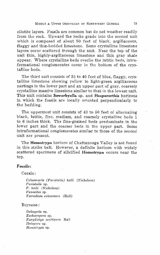
MIDDLE & UPPER 0RDIVICIAN OF NORTHWEST GEORGIA 73
cilutite layers. Fossils are common but do not weather readily from the rock. Upward the rocks grade into the second unit which is composed of about 50 feet of black, argillaceous, flaggy and thin-bedded limestone. Some crystalline limestone layers occur scattered through the unit. Near the top of the unit thin, highly-argillaceous limestone and thin gray shale appear. Where crystalline beds overlie the lutitic beds, intraformational conglomerates occur in the bottom of the crystalline beds.
The third unit consists of 35 to 40 feet of blue, flaggy, crystalline limestone showing yellow to light-green argillaceous partings in the lower part and an upper part of gray, coarsely crystalline massive limestone similar to that in the lowest unit. This unit contains Sowerbyella sp. and Hesperorthis horizons in which the fossils are locally oriented perpendicularly to the bedding.
The uppermost unit consists of 40 to 50 feet of alternating black, lutitic, fine, medium, and coarsely crystalline beds 1 to 6 inches thick. The fine-grained beds predominate in the lower part and the coarser beds in the upper part. Some intraformational conglomerates similar to those of the second unit are present.
The Homotrypa horizon of Chattanooga Valley is not found in this strike belt. However, a definite horizon with widely scattered specimens of silicified Homotrypa occurs near the top.
Fossils:
Corals:
Columnaria (Favistella) halli (Nicholson) Favistella sp. F. halli (Nicholson) Favosites sp. Tetradium columnare (Hall)
Bryozoa:
Dekayella sp. Eschar·opora sp. Eurydictya multi.pora Hall Helopora sp. H omob·ypa sp.
74 •GEORGIA GEOLOGICAL SURVEY BULLETIN 66
Brachiopods:
Ancistrorhyncha costata Ulrich & Cooper Hespero1·this tricenaria (Conrad) Oxoplecia holstonensis Willard Pionodema sp. P. S'ltbaequata (Conrad) Sowerbyella sp. Strophomena incurvata (Shepard) S. planumbona Hall RafineSquina sp. Zygospira. sp. Z. modesta Say Z. recurvirostris (Hall)
Gastropods:
Liospira sp. Lophospi'i·a sp.
Cephalopod:
Orthoceras sp.
Trilobite:
Isotelus sp.
Ostracod:
Leperditia sp.
Location of Outcrops:
1) 1400 to 1800 feet southeast of the bridge on Banks Pond Road across Little Chickamauga Creek in East Ridge Quadrangle.
2) Along Catlett Gap Road southeastward from its intersection with McLemore Cove Road, Kensington Quadrangle.
3) Along Mill Creek in the northwestern corner of the Kensington Quadrangle.
4) At the quarry one and one-half miles north of Cooper Heights in the Durham Quadrangle.
5) 1500 feet west of U. S. Highway 11 along Town Creek near Trenton, Georgia.
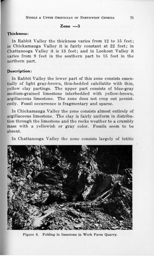
MIDDLE & UPPER 0RDIVICIAN OF NORTHWEST GEORGIA 75
Zone -3
Thickness:
In Rabbit Valley the thickness varies from 12 to 15 feet; in Chickamauga Valley it is fairly constant at 22 feet; in Chattanooga Valley it is 13 feet; and in Lookout Valley it varies from 9 feet in the southern part to 15 feet in the northern part.
Description:
In Rabbit Valley the lower part of this zone consists essentially of light gray-brown, thin-bedded calcilutite with thin, yellow clay partings. The upper part consists of blue-gray medium-grained limestone interbedded with yellow-brown, argillaceous limestone . The zone does not crop out persistently. Fossil occurrence is fragmentary and sparse.
In Chickamauga Valley the zone consists almost entirely of argillaceous limestone. The clay is fairly uniform in distribution through the limestone and the rocks weather to a crumbly mass with a yellowish or gray color. Fossils seem to be absent.
In Chattanooga Valley the zone consists largely of lutitic
Figure 8. Folding in limestone in Work Farm Quarry.
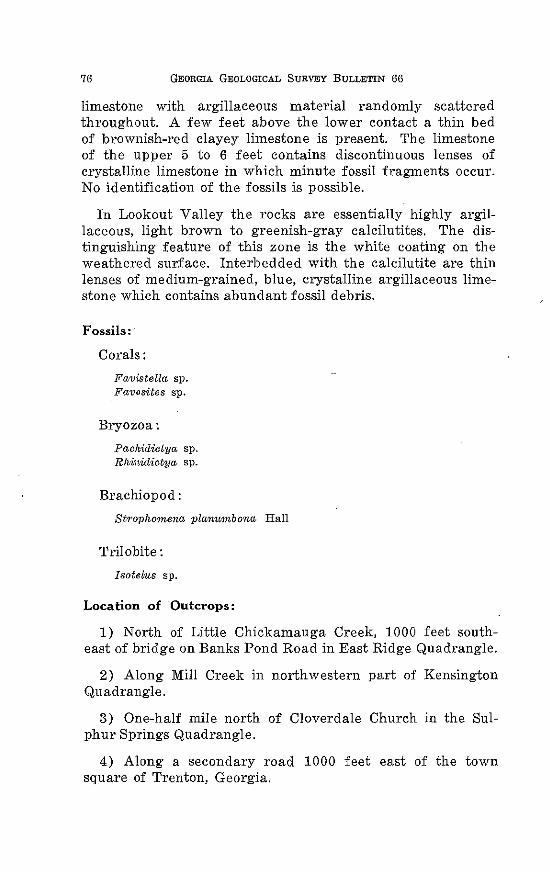
76 GEORGIA GEOLOGICAL SURVEY BULLETIN 66
limestone with argillaceous material randomly scattered throughout. A few feet above the lower contact a thin bed of brownish-red clayey limestone is present. The limestone of the upper 5 to 6 feet contains discontinuous lenses of crystalline limestone in which minute fossil fragments occur. No identification of the fossils is possible.
In Lookout Valley the rocks are essentially highly argillaceous, light brown to greenish-gray calcilutites. The distinguishing feature of this zone is the white coating on the weathered surface. Interbedded with the calcilutite are thin lenses of medium-grained, blue, crystalline argillaceous limestone which contains abundant fossil debris.
Fossils:
Corals:
Favistella sp. Favosites sp.
Bryozoa:
Pachidictya sp. Rhinidictya sp.
Brachiopod:
StTophomena plant~mbona Hall
Trilobite:
Isotelus sp.
Location of Outcrops:
1) North of Little Chickamauga Creek, 1000 feet southeast of bridge on Banks Pond Road in East Ridge Quadrangle.
2) Along Mill Creek in northwestern part of Kensington Quadrangle.
3) One-half mile north of Cloverdale Church in the Sulphur Springs Quadrangle.
4) Along a secondary road 1000 feet east of the town square of Trenton, Georgia.
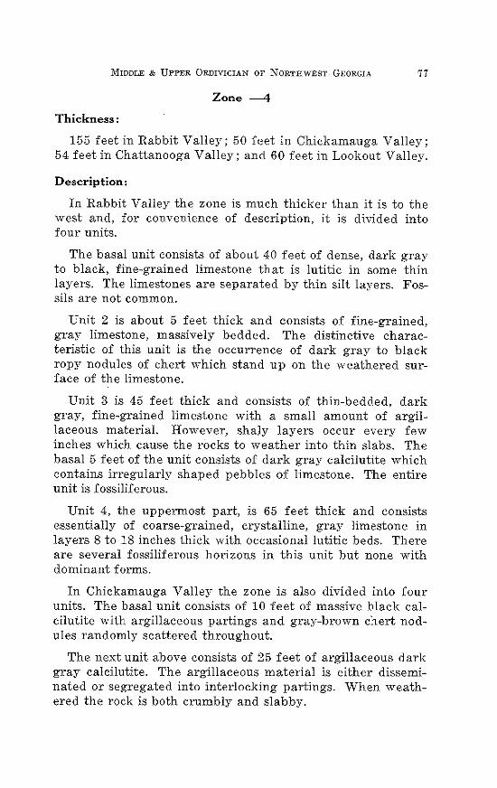
MIDDLE & UPPER 0RDIVICIAN OF NORTHWEST GEORGIA 77
Zone -4
Thickness:
155 feet in Rabbit Valley; 50 feet in Chickamauga Valley; 54 feet in Chattanooga Valley; and 60 feet in Lookout Valley.
Description:
In Rabbit Valley the zone is much thicker than it is to the west and, for convenience of description, it is divided into four units.
The basal unit consists of about 40 feet of dense, dark gray to black, fine-grained limestone that is lutitic in some thin layers. The limestones are separated by thin silt layers. Fossils are not common.
Unit 2 is about 5 feet thick and consists of fine-grained, gray limestone, massively bedded. The distinctive characteristic of this unit is the occurrence of dark gray to black ropy nodules of chert which stand up on the weathered surface of the limestone.
Unit 3 is 45 feet thick and consists of thin-bedded, dark gray, fine-grained limestone with a small amount of argillaceous material. However, shaly layers occur every few inches which cause the rocks to weather into thin slabs. The basal 5 feet of the unit consists of dark gray calcilutite which contains irregularly shaped pebbles of limestone. The entire unit is fossiliferous.
Unit 4, the uppermost part, is 65 feet thick and consists essentially of coarse-grained, crystalline, gray limestone in layers 8 to 18 inches thick with occasional lutitic beds. There are several fossiliferous horizons in this unit but none with dominant forms.
In Chickamauga Valley the zone is also divided into four units. The basal unit consists of 10 feet of massive black calcilutite with argillaceous partings and gray-brown chert nodules randomly scattered throughout.
The next unit above consists of 25 feet of argillaceous dark gray calcilutite. The argillaceous material is either disseminated or segregated into interlocking partings. When weathered the rock is both crumbly and slabby.
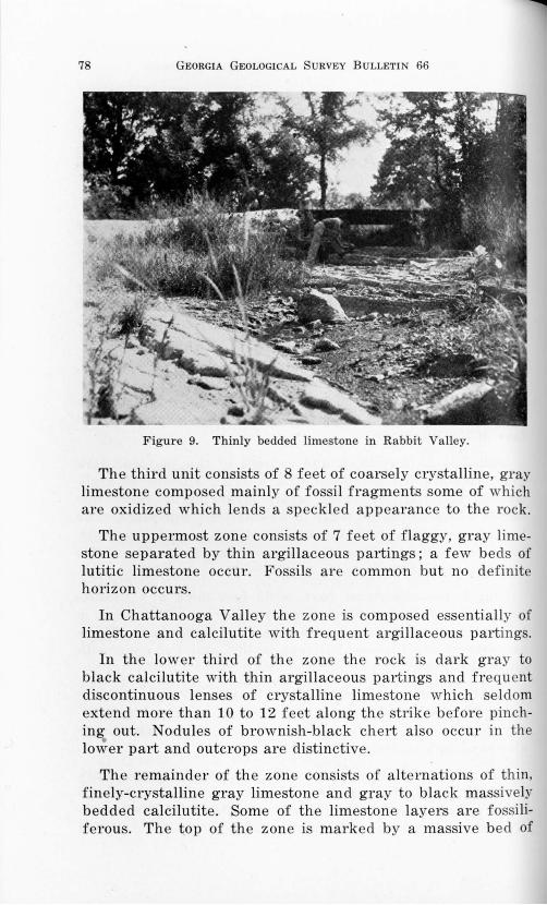
78 GEORGIA GEOLOGICAL URVEY BULLETIN 66
Figure 9. Thinly bedded limestone in Rabbit Valley.
The third unit consists of 8 feet of coarsely crystalline, gray limestone composed mainly of fossil fragments some of which are oxidized which lends a speckled appearance to the rock.
The uppermost zone consists of 7 feet of f laggy, gray limestone separated by thin argillaceous partings; a few beds of lutitic limestone occur. Fossils are common but no definite horizon occurs.
In Chattanooga Valley the zone is composed essentially of limestone and calcilutite with frequent argillaceous partings.
In the lower third of the zone the rock is dark gray to black calcilutite with thin argillaceous partings and frequent discontinuous lenses of crystalline limestone which seldom extend more than 10 to 12 feet along the strike before pinching out. Nodules of brownish-black chert also occur in the
• lower part and outcrops are distinctive.
The remainder of the zone consists of alternations of thin, finely-crystalline gray limestone and gray to black massively bedded calcilutite. Some of the limestone layers are fossi liferous . The top of the zone is marked by a massive bed of
MIDDLE & UPPER 0RDIVICIAN OF NORTHWEST GEORGIA 79
gray, fossiliferous, crystalline limestone.
In Lookout Valley it consists in the lower half of black, flaggy calcilutite which grades upward into massive beds of gray, fine- to medium-grained crystalline limestone. Black chert nodules occur in the middle 15 feet of the zone.
The upper half consists of gray to black massive beds of coarse-grained limestone which shows cross-bedding and contains oolites, fine fossil debris, and small pyrite crystals. On weathering the pyrite produces iron-stained spots which give the rock a speckled appearance.
Argillaceous material comprises from 15 to 25 percent of the rock. Fossil fragments are common but complete specimens are rare.
Fossils:
Sponges:
Cryptophragmus antiquatus (Raymond) Stromatoeerium 1"Ugosum (Hall)
Corals:
Favosites sp. Tetradium cellulosum (Hall)
Bryozoan:
Batostoma sp.
Brachiopods:
Ancistrorhyneha sp. DalmaneUa sp" Fascifera subcarinata Ulrich & Cooper H esperorthis tricenaria (Conrad) Pionodema minuscula (Willard) Rafinesquina tTentonensis (Conrad) Sowerbyella punctoB'triata (Mather) Strophornena incurvata (Shepard) S. planum,bona Hall Zygospira, recurvirostris (Hall)
Gastropods:
Liospira progne (Billings)
80 GEORGIA GEOLOGICAL SURVEY BULLETIN 66
Lophospi?·a swrrulatus (Salter) Plwa-{)11tolites fimbriatus Ulrich & Scofield
Cephalopod:
Trilobites:
Bathyut(,ts sp. Ca,lliops callicephakt (Hall) I sotelus sp.
Ostracods:
Leperditia sp. L. fa . .bulites (Conrad)
Location of Outcrops:
1) North of Little Chickamauga Creek, 800 feet southeast of bridge on Banks Pond Road in the East Ridge Quadrangle.
2) At quarry one and one-half miles north of Cooper Heights in the Durham Quadrangle.
3) Along Mill Creek in the northwestern corner of the Kensington Quadrangle.
4) One-half mile north of Cloverdale Church in the Sulphur Springs Quadrangle.
5) East of U.S. Highway 11 about one-half mile northeast of Alabama-Georgia boundary, Hooker Quadrangle.
Zone -5
Thickness:
15 feet in Rabbit Valley; 13 feet in Chickamauga Valley; 8 feet in Chattanooga Valley; and 10 feet in Lookout Valley.
Description:
In Rabbit Valley this zone consists essentially of gray, fineg-rained, finely crystalline, thin limestone layers separated by thin shale partings. Many of the layers are highly fossiliferous but the fossils do not weather from the rock and exact identification is extremely difficult.
MIDDLE & UPPER 0RDIVICIAN OF NORTHWEST GEORGIA 81
In Chickamauga Valley the lower 7 feet consists of alternating beds of black calcilutite and thin beds of gray crystalline limestone with argillaceous partings between the limestones. The upper 6 feet consist of gray limestone enclosing numerous algae colonies of the genus Solenopora. The colonies are small and so plentiful as to give the rock, upon cursory examination, the appearance of a limestone conglomerate.
In Chattanooga Valley it consists almost entirely of a pure, blue-gray, coarse-grained, crystalline limestone and occasional beds of dark gray calcilutite. A profusion of Solenopora masses are found in the zone and considering the zone's thinness, the lithology and the Solenopora it becomes an excellent marker.
In Lookout Valley it consists of gray, medium-grained, cobbly limestone interbedded with massive beds of gray, coarsely crystalline limestone. The distinctive features in this belt are the persistence of the purity of the limestone and the thickness of the zone along the strike together with the profusion of Solenopora colonies. The colonies appear as light gray pebbles and give the limestone a conglomeratic appearance.
Fossils:
Alga:
Solenopora cf. S. compacta (Billings)
Sponges:
Cryptophragmus antiquatus (Raymond)
Corals:
Favosites sp. Tetradiu-m columnare (Hall) Tetradit1.:1n syringoporoides ( ?)
Bryozoa:
Rhinidictya mutabilis Ulrich
Brachiopods:
Glyptorthis cf. G. bellantgosa (Conrad) Pionoderna sp. Strophornena sp.
82 GEORGIA GEOLOGICAL SURVEY BU.LLETIN 66
S. planumbona Hall Zygospira 1·ecurvirostris Hall
Trilobite:
I sotelus sp.
Ostracod:
Leperditia sp.
Location of Outcrops:
1) North of Little Chickamauga Creek, 600 feet southeast of bridge on Banks Pond Road in East Ridge Quadrangle.
2) Along Mill Creek in northwestern part of Kensington Quadrangle.
3) Along the east side of Georgia Highway 193 one-half mile north of Cooper Heights in the Durham Quadrangle.
4) 200 feet east of U.S. Highway 11 at a point about threefourths mile northeast of Alabama-Georgia boundary, Hooker Quadrangle.
5) 1200 feet west of U. S. Highway 11 along Town Creek in Trenton Quadrang·le.
Zone -6
Thickness:
85 feet thick in Rabbit Valley; 40 feet in Chickamauga Valley; 49 feet in Chattanooga Valley; and 15 feet in Lookout Valley.
Description:
In Rabbit Valley the zone may be divided into three units, the lowest consisting of 25 feet of gray, coarse-grained, crystalline limestone with ropy black chert nodules which form on the bedding planes and stand out in relief upon weathering.
Above this unit are about 40 feet which consist of gray, coarse-grained, crystalline limestone in beds 1 to 3 feet thick. The upper 3 feet contain numerous colonies of Solenopora. The lower 2 feet is composed of finely banded limestone and thin silt layers.
MIDDLE & UPPER 0RDIVICIAN OF NORTHWEST GEORGIA 83
The upper unit, 20 feet thick, consists of dark gray calcilutite with irregular shale partings. The weathered surface of the rock is blue-gray with small irregularly shaped, brownish spots.
In Chickamauga Valley the rock consists essentially of gray crystalline limestone with some scattered beds of darker gray Iutitic limestone. The crystalline layers are often fossiliferous.
In Chattanooga Valley the basal 10 feet are brownish-blue highly argillaceous, finely crystalline and lutitic limestone which weathers to crumbly brown pebbles. This part of the zone is very fossiliferous but no one fossil form predominates. The next 20 feet consist essentially of brown to reddish-brown fissile shale. The remainder of the zone is composed of limestone with less than 5 percent argillaceous material which alternates with dark gray calcilutite.
In Lookout Valley the zone consists of about 15 feet of blue to gray, flaggy, argillaceous, crystalline limestone which weathers to a dull yellowish-brown color. The base of the zone consists of 2 feet of coarsely crystalline, cross-bedded limestone. This zone does not crop out persistently in Lookout Valley.
Fossils:
Bryozoa:
A rthroelema. armatum Ulrich Helopora spiniformis (Ulrich) H omotrypa minnesoten.sis Ulrich Prasopo1·a sp. Rhinidictya 'Yl?./ottabilis Ulrich Stictop01·ella sp.
Brachiopods:
Ancistrorhyncha costata Ulrich & Coope1· Dinorthis cf. D. atavoides Willard Glyptorthis bellM·ugosa (Conrad) H ebertella sp. Hesperorthis tricenaria (Conrad) Multicostella sp. Pionodema subaequata (Conrad) Sowerbyella sp. Zygospira Tecurvirostris (Hall)
84 GEORGIA GEOLOGICAL SURVEY BULLETIN 66
Gastropod:
Lophospb·a sp.
Cephalopod:
Ostracod:
Lepe·rditia fabulites (Conrad)
Location of, Outcrops:
1) North of Little Chickamauga Creek, 600 feet east of bridge on Banks Pond Road in the East Ridge Quadrangle.
2) At the quarry one and one-half miles north of Cooper Heights in the Durham Quadrangle.
3) 300 feet west of the main road to McLemore Cove onefourth mile north of Cedar Grove, Durham Quadrangle boundary.
4) 100 feet north of Cloverdale Church in Sulphur Springs Quadrangle.
Zone -7
Thickness:
130 feet in Rabbit Valley; 97 feet in Chickamauga Valley; 90 feet in Chattanooga Valley; and 66 feet in Lookout Valley.
Description:
In Rabbit Valley Zone -7 may be divided into three units. The lowest of which is about 4 7 feet thick and consists of yellowish-gray, argillaceous, limestone with shaly partings which weathers readily into thin layers. After weathering the limestone surface assumes a blue-gray color. The lower part of this unit is marked by 8 to 10 feet of gray, massive, crystalline limestone in beds 1 to 3 feet thick. In this part of the unit a Homotrypa horizon predominates. Unit 2 is about 45 feet thick and is composed entirely of thin, calcareous siltstones which are red, brownish-red, greenish-yellow and tan in color. The beds are usually less than an inch thick. The
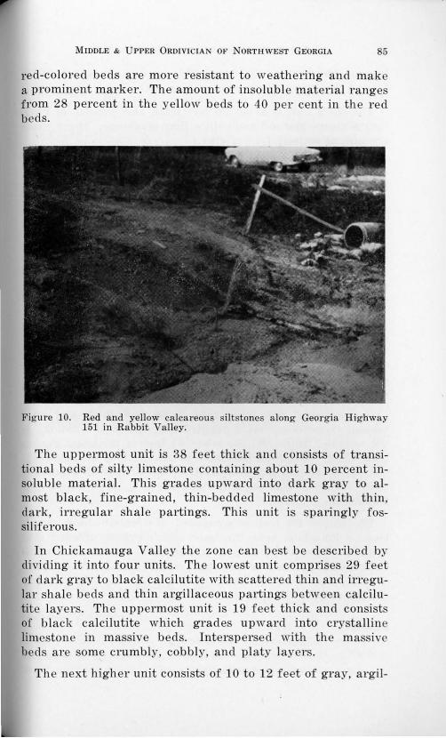
MIDDLE & UPPER 0RDIVICIAN OF ORTHWEST GEORGIA 85
red-colored beds are more resistant to weathering and make a prominent marker. The amount of insoluble material range from 28 percent in the ye llow beds to 40 per cent in the red beds.
Figure 10. Red and yellow calcareous s il tstones along Georgia Highway 151 in Rabbit Valley.
The uppermost unit is 38 feet thick and consists of transitional beds of silty limestone containing about 10 percent insoluble material. This grades upward into dark gray to almost black, fine-grained, thin-bedded limestone with thin, dark, irregular shale partings. This unit is sparingly fossiliferous.
In Chickamauga Valley the zone can best be described by dividing it into four units. The lowest unit comprises 29 feet of dark gray to black calcilutite with scattered thin and irregular shale beds and thin argillaceous partings between calcilutite layers. The uppermost unit is 19 feet thick and consist of black calcilutite which grades upward into crystalline lim stone in massive beds. Interspersed with the massi e beds are orne crumbly, cobbly, and platy layer .
The next higher unit consists of 10 to 12 feet of gray, argil-
86 GEORGIA GEOLOGICAL SURVEY BULLETIN 66
laceous limestone at its base. This is overlain by about 20 feet of flaggy calcilutite alternating with thin shale beds.
The third unit is about 20 feet thick and consists of blue, limy siltstone and red and yellow limy mudstone. These rocks are almost entirely free of clay.
In Chattanooga Valley the lower 29 feet consist of brownish-gray, argillaceous, crystalline to lutitic limestone which is fossiliferous; thinly-laminated silty limestone; and some less argillaceous blue-gray limestone which contains dark-brown to black ropy chert nodules.
The middle 30 feet consists of thin-bedded unlaminated, brown, silty limestone most of which is elastic; upon weathering it appears as brownish-red rock similar to siltstone and can best be detected by treatment with acid. Fossils are not numerous.
The upper 30 feet is composed of thick-bedded limestone; in the lower part it alternates with beds of gray calcilutite with fine-textured intraformational conglomerates and in the upper part the massive limestone does not alternate with calcilutite but becomes more fossiliferous and some thin beds are composed almost entirely of fossil debris.
In Lookout Valley, this zone is 66 feet thick and only seldom exposed so that a detailed description of lithology is not reliable. However, the lower 31 feet of thickness grades from thinly-laminated limestone to alternations of blue-gray, fine- to medium-grained crystalline limestone with abundant fossil remains. One fossil horizon shows a large number of Solenopora colonies.
The upper 35 feet is composed of thinly-bedded, argillaceous limestone near the base which grades upward into siltstone of red and brown color, much of which is calcareous. Cross-bedding, mud cracks, and ripple marks are common in some exposures. In the northern part of the belt the beds change to blue calcareous sandstone.
Fossils:
Alga:
Solenopm"a compacta (Billings)
MIDDLE & UPPER 0RDIVICIAN OF NORTHWEST GEORGIA 87
Corals:
Tetradium sp. T. sy?'ingop01''oides Ulrich
Bryozoa:
Dekayella p1·aenuntia Ulrich Dictyonella Teticulata (Hall) H e"Zopora spinijormis Ulrich Hemiphragmus impeTjectus (Ulrich) Nicho.Zsonella sp.
Brachiopods:
Cyclospira sp. Desmorthis nevadensis Ulrich & Cooper Doleroides gibbosus (Billings) Glyptortkis insculpta (Hall) Hesperorthis sp. Idiostrophis sp. Mimella melonica Willard Rajinesquina minnesotens~·s vv-inchell Resserella, sp. R. rogata (Sanderson) RostriceUa plena (Hall) Strophomena sp. S. planumbona Hall
Gastropods:
Liospira vitruvia Billings M aclurites sp. Ophileta levata (Vanuxem)
Cephalopods:
Goniocera.s anceps Hall MichelinOceras sociale Hall
Ostracod:
Leperditia cf. L. fabulites (Conrad)
Location of Outcrops:
1) In the west flowing tributary of Hurricane Creek 500 feet east of Georgia Highway 151, eight-tenths mile south of the Tennessee-Georgia boundary, Ringgold Quadrangle.
88 GEORGIA GEOLOGICAL SURVEY BULLETIN 66
2) Along Mill Creek in the northwestern corner of the Kensington Quadrangle.
3) One-third mile north of Cooper Heights in the Durham Quadrangle.
4) 200 feet east of U. S. Highway 11 about three-fourths mile northeast of the Alabama-Georgia boundary, Hooker Quadrangle.
5) Six-tenths mile north of Cloverdale Church in the Sulphur Springs Quadrangle.
Zone -8
Thickness:
28 feet in Rabbit Valley; 12 feet in Chickamauga Valley; 20 feet in Chattanooga Valley; and absent in Lookout Valley.
Description:
In Rabbit Valley the basal 8 to 10 feet consist of gray, massive, coarsely crystalline limestone in beds 1 to 3 feet thick. Above this are 10 to 12 feet of dark gray, massive lutitic limestone which contains numerous white calcite "eyes." Above the lutitic limestone is about 8 feet of light gray, fine-grained, crystalline limestone which contains a fossiliferous horizon in which Homotrypa fragments predominate.
In Chickamauga Valley the entire 12 feet of the zone is composed of pure, light-gray calcilutite in massive beds. Insoluble material varies from 4 to 12 percent. Numerous stylolites are present.
In Chattanooga Valley the zone consists of brittle, pure, massively bedded, light gray calcilutite with numerous small but conspicuous white calcite "eyes". On some exposures weathering has produced a chalky coating which gives an almost white color to the rock. Fossils are rare.
In Lookout Valley this zone does not crop out.
Fossils:
Coral:
Favistella sp.
MlDDLE & UPPER 0RDIVICIAN OF NORTHWEST GEORGIA 89
Bryozoa:
Homotrypa sp.
Brachiopods:
Cyclospi'ra sp. Protozyga sp. Zygospira sp.
Gastropod:
Lophospira sp.
Location of Outcrops:
1) East of Little Chickamauga Creek 2000 feet east of Banks Pond in the East Ridge Quadrangle.
2) Along Mill Creek in northwestern corner of Kensington Quadrangle.
3) At the northeast corner of road intersection at High Point in the Kensington Quadrangle.
Zone -9
Thickness:
15 feet in Rabbit Valley; 37 feet in Chickamauga Valley; 47 feet in Chattanooga Valley; and 50 feet in Lookout Valley.
Description:
In Rabbit V :;tlley the most distinctive feature is the presence of brownish-black chert nodules of irregular shape which occur in the massively bedded, dark blue-gray, fine-grained limestone. Small irregularly shaped, white calcite "eyes" also occur in the limestone. The chert may be ropy of spherical shape and stand in relief above the weathered surface of the limestone.
In Chickamauga Valley the zone consists of massive, pure, gray crystalline limestone at the top of the zone with argillaceous material increasing slightly toward the base. The presence of ropy and nodular chert which weathers brownishblack make the zone a distinctive marker. Thin layers composed essentially of fossil debris occur.
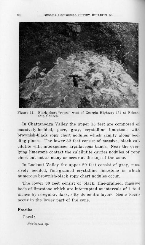
90 GEORGIA GEOLOGICAL SURVEY BULLETIN 66
Fig ure 11. Black chert "ropes" west of Georgia Highway 151 at Friendship Church.
In Chattanooga Valley the upper 15 feet are composed of massively-bedded, pure, gray, crystalline limestone with brownish-black ropy chert nodules which ramify along bedding planes. The lower 32 feet consist of massive, black calcilutite with interspersed argillaceous bands. Near the overlying limestone contact the calcilutite carries nodules of ropy chert but not as many as occur at the top of the zone.
In Lookout Valley the upper 20 feet consist of gray, massively bedded, fine-grained crystalline limestone in which numerous brownish-black ropy chert nodul es occur.
The lower 30 feet consist of black, fine-grained, massive beds of limestone which are interrupted at intervals of 1 to 4 inches by irregular, dark, silty dolomitic layers. Some fossils occur in the lower part of the zone.
Fossils:
Coral:
Favistella sp.
MIDDLE & UPPER 0RDIVICIAN OF NORTHWEST GEORGIA 91
Brachiopods:
Rafinesquina cf. R. deltoidea (Conrad) Strophomena incurvata (Shepard) S. tennesseensis Willard Zygospira sp.
Cephalopod:
Michelinoce-;·as multicame1·atum Emmons
Ostracods:
Unidentified
Location of Outcrops:
1) A few yards west of Georgia Highway 151 in the west flowing tributary of Hurricane Creek eight-tenths mile south of the Tennessee-Georgia boundary, Ringgold Quadrangle.
2) Along the intersection of West Chickamauga Creek and the road east from Thurman Cemetery in the Cedar Grove Quadrangle.
3) One-third mile north of Cooper Heights in the Durham Quadrangle.
4) 200 feet east of U. S. Highway 11 about one-half mile northeast of the Alabama-Georgia boundary, Hooker Quadrangle.
Zone -10
Thickness:
135 feet in Rabbit Valley; 238 feet in Chickamauga Valley; 203 feet in Chattanooga Valley; and 218 feet in Lookout Valley.
Description:
Zone -10 in Rabbit Valley consists of massive, blue-gray to almost black calcilutite in the lower third; of gray, crystalline limestone with silt partings which help the limestone weather into thin slabs in the middle third; the upper third consists of dark gray calcilutite which is massively bedded and weathers to slabs 3 to 8 inches thick. The middle third
92 GEORGIA GEOLOGICAL SURVEY BULLETIN 66
! is fossiliferous and fossils weather from the rock. The lower part is also fossiliferous but none weather out.
In Chickamauga Valley the rock is essentially dark gray to black calcilutite with thin argillaceous partings separating the massive beds. Toward the bottom of the zone silt gradually replaces the argillaceous material. Fossils are not common.
In Chattanooga Valley the zone consists of a monotonous sequence of dark gray to black calcilutites separated by argillaceous partings. The partings are not uniform and their closeness causes the rock to break either into thin slabs of a few inches in thickness or into thick blocks of 2 to 3 feet. Near the base the rocks are more argillaceous. Mud cracks are common at several horizons in the lower 50 feet. Argillaceous material diminishes toward the top and where the limestones are purer some scattered fossil fragments occur.
In Lookout Valley the lower 15 to 20 feet consist of thinbedded dark gray calcilutite separated by thin, black argillaceous partings. Argillaceous material increases toward the middle where the partings assume a yellowish-brown color. Some mud cracks occur at various horizons in the lower 30 feet.
Upward the argillaceous material almost disappears; the beds become thicker and weathered blocks are often 3 feet or more thick. Fossils occur sporadically through the zone. Near the top are some thin beds of crystalline limestone in which fossil debris is plentiful.
Fossils:
Alga:
Solenopora compacta (Billings)
Coral:
Favistella sp.
Bryozoa:
E scha-ropoTa sub1·ecta Ulrich Rhinidictya rnutabilis Ulrich
MIDDLE & UPPER 0RDIVICIAN OF NORTHWEST GEORGIA 93
Brachiopods:
Dinorthis sp. Glyptorthis sp. Pionodem.a minuscula (Willard) Rafinesquina sp. Rostricellula sp. Strophomena ten~usseensis Willard Valcourea sp. Zygospira 1·ecurvirostris (Hall)
Gastropods:
Helicotoma tennesseensis (Ulrich & Scofield) Raphistoma peracutum Ulrich & Scofield
Cephalopods:
Cyclostomiceras cassinense (Whitfieid) Gonioceras sp.
Trilobite:
DipleuTa dekayi Green
Ostracod:
Ba.thocyp1·is cylindrica (Hall)
Location of Outcrops:
1) In a small west flowing tributary to south Chickamauga Creek 800 to 1200 feet west of Georgia Highway 151 north of Ringgold, Georgia.
2) Three-fifths mile north-northeast of Cooper Heights in Durham Quadrangle.
3) Six-tenths mile north of Miller Cemetery in Sulphur Springs Quadrangle.
Zone -11
Thickness:
In Rabbit Valley it is 258 feet; 69 feet in Chickamauga Valley; 80 feet in Chattanooga Valley; and 120 feet in Lookout Valley.
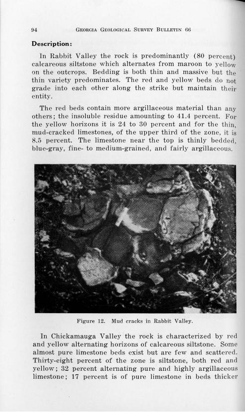
94 G EORGIA GEOLOGICAL S URVEY BULLETIN 66
Description:
In Rabbit Valley the rock is predominantly ( 80 percent) calcareous si ltstone which alternates from maroon to yel low on the outcrops. Bedding is both thin and massive but the thin variety predominates. The r ed and yellow beds do not grad e into each other a long the strike but maintain their entity.
The red beds contain more argillaceous material than any others ; the insoluble residu e amounting to 41.4 percent. For the ye llow horizons it is 24 to 30 percent and for the thin, mud-cracked limestones, of the upper third of the zone, it is 8.5 percent. The limestone near the top is thinly bedd ed, blue-gray, fine- to medium-grained, and f airly argillaceous.
Figure 12. Mud cracks in Rabbit Valley.
In Chickamauga Valley the rock is characterized by red and yellow alt ernating horizons of calcareous si ltstone . Some almost pure limestone beds exist but are f ew and scattered. Thirty-eight percent of the zone is siltstone, both r ed and yellow; 32 percent a lternating pure and highly argillaceous limestone ; 17 percent is of pure limestone in beds thicker
MIDDLE & UPPER 0RDIVICIAN OF NORTHWEST GEORGIA 95
than 1 foot; and 13 percent in beds of argillaceous limestone less than 1 foot thick.
Fossils are rare but some recognizable forms occur in the red and yellow beds.
In Chattanooga Valley the lower half of the zone is highly argillaceous and the limestone shows mud cracks. Red and yellow beds are common but red predominates. Upward the beds decrease in argillaceous material and the partings become thinner, the mud cracks and red color disappear. Near the top, however, the argillaceous material again increases, the red color returns, and mud cracks again become common.
The red horizons are not persistent along the strike and and disappear occasionaly without any recognizable cause. Fossils are poorly preserved.
In Lookout Valley the lowest member is a light gray, massively bedded, friable calcilutite, which grades upward into more argillaceous rocks.
The beds of the middle portion are light-gray calcilutite and contain yellow laminae, mud cracks, and occasional intraformational conglomerates. Olive-drab, crumbly, very argillaceous lutitic beds with a white chalky crust occur in association with the mud-cracked layers.
Near the top an occasional bed of black calcilutite occurs but in general the dark-colored limestone is absent. Three beds of yellow, silty limestone occur interbedded with the calcilutite in the upper part of the zone. Fossils are rare.
Fossils:
Coral:
Favistella sp.
Brachiopod:
Ling~tla sp. Strophomena planumbona Ha!l
Cephalopod:
96 GEORGIA GEOLOGICAL SURVEY BULLETIN 66
Location of Outcrops:
1) 800 feet west of Georgia Highway 151 at Friendship Church in the northern part of Ringgold Quadrangle.
2) Three-fifths mile north-northeast of Cooper Heights in the Durham Quadrangle.
3) Along an old logging road 1400 feet southwest of Cloverdale Church in Sulphur Springs Quadrangle.
Zone -12
Thickness:
112 feet in Rabbit Valley; 54 feet in Chickamauga Valley; 54 feet in Chattanooga Valley; and 30 feet in Lookout Valley.
Description:
In Rabbit Valley the lower third consists of lig·ht-gray, dense, fine-grained limestone containing several thin layers of fossil debris but no identifiable fossils. Scattered throughout the lower third are irregularly shaped pebble-size masses of Monticulopora sp. The silt content of the rocks in this part of the zone is about 7 percent.
The upper two-thirds of the zone consists of thick-bedded, gray, calcilutite with numerous white to almost colorless calcite "eyes".
In Chickamauga Valley the lower one-third of the zone consists of nearly pure, light-gray to dark-gray calcilutite. The argillaceous content increases upward until in the middle portion beds of yellow argiliaceous limestone occur.
The upper part of the zone is similar to the lower part except the color of the calcilutite becomes almost black. Fossil debris occurs at variorrs horizons in the lower part of the zone. Identification is difficult.
In Chattanooga Valley the basal 9 feet are brownish-gray, highly argillaceous, dolomitic limestone and the silt and clay are colored in various shades of brown and yellow. Fossils in this part are very abundant. The next 21 feet crop out in scattered exposures which are all highly argillaceous and dolomitic and the clay and silt occur as segregations. The
MIDDLE & UPPER 0RDIVICIAN OF NORTHWEST GEORGIA 97
upper 24 feet consist of massively bedded, light gray, dense, very fine-grained limestone which grades upward into light gray calcilutite. The upper limit of the zone is a black, fossiliferous, fine-grained limestone.
In Lookout Valley the zone consists of dark gray, mediumand fine-grained limestone. The insoluble residue in this rock is about 5 percent. The change from limestone to the calcilutite of Zone -11 is gradational.
Fossils:
Bryozoa:
M onticulipo1·a sp.
Brachiopod:
Hesperorthis sp.
Cephalopod:
Orthoceras sp.
Location of Outcrops:
1) 2000 feet west of Georgia Highway 151 near Friendship Church in the Ringgold Quadrangle.
2) At the intersection of Coulter Branch and the main road in Chattanooga Valley, one-half mile southwest of Coulter Cemetery in the Durham Quadrangle.
3) 1500 feet southwest of Cloverdale Church m Sulphur Springs Quadrangle.
4) 500 feet north of State Line Church on U. S. Highway 11 just at the Alabama-Georgia boundary, Hooker Quadrangle.
Zone -13
Thickness:
124 feet in Rabbit Valley; 149 feet in Chickamauga Valley; 86 feet in Chattanooga Valley; and 230 feet in Lookout Valley.
98 GEORGIA GEOLOGICAL SURVEY BULLETIN 66
Description:
In Rabbit Valley the bottom part consists of light-gray, fine-grained massively bedded limestone which in some horizons is dolomitic. Chert layers 1 to 4 inches thick of a light blue or milky gray color occur in all exposures more than 1 foot thick; the chert makes up about 10 percent of the entire lower part of the zone. The basal part of the zone is at the top contact of the Knox dolomite.
The upper half consists of mottled blue-gray, green, purple, and pink limestone which makes it a distinctive marker. Color varies along the strike. Bedding is fairly uniform throughout the upper part.
In Chickamauga Valley the lower 104 feet consist of alternating light gray limestone, darker gray dolomite and dolomitic limestone with massive beds. Yellow~ mottling is frequent on the few beds of calcilutite which occur in the section.
The upper 45 feet consist of massive beds of limestone which are mottled in shades of red, purple, gray, green, and yellow. Some silt and small sandy lenses occur and at one horizon detrital chert of white color and angular shape is found. Some horizons are fossiliferous.
In Chattanooga Valley the basal unit of 28 feet is composed of interbedded chert conglomerates and reddish-brown fissile shales, slightly fossiliferous. Above this unit are 30 feet of red, yellow, and brown mottled sandy silts and silty clays. Upward these rocks grade into gray, argillaceous, finegrained, dolomitic limestone. Most of the argillaceous material is silt and the dolomite appears in association with it. Fossils are not co1nmon.
In Lookout Valley the base is marked by an irregular bed of basal clastics composed of rounded quartz pebbles and sand, rounded pebbles of lutitic limestone, black subangular chert with a calcareous cement. Above the basal clastics are 40 feet of light-gray to yellow calcilutite with beds 1 to 3 feet thick. Some thin-bedded calcilutites and medium-grained dolomites are interspersed in the 40 feet.
The calcilutite grades upward into dark-gray, massive, coarsely crystalline dolomite which in tun1 grades upward
MIDDLE & UPPER 0RDIVICIAN OF NORTHWEST GEORGIA 99
into fine-grained dolomite and yellow to brown, fine- to medium-grained dolomitic limestone. The upper 10 feet is marked by light-yellow, silty limestone which grades into the purer limestone comprising the upper 130 feet of the zone.
The upper part consists of gray, massive, fine- to mediumgrained limestone containing abundant helicoid and planospiral gastropods and other fossil debris. At the top of the zone the limestone becomes light yellow to green in color.
Fossils:
Alga:
Cryp·tozoon
Coral:
Lichenaria sp.
Bryozoa:
Callopora pulchella ? Montimtlopora sp.
Brachiopods:
Finkelnburgia sp. RostTicellula rostrata Ulrich & Cooper
Gastropods:
Ho1·nwtoma sp. H. bellicincta (Hall) Lecanospira sp. Lophospira sp. Maclu1·ites sp. Raphistoma sp. Sibulites sp.
Cephalopod:
Location of Outcrops:
1) West of Georgia Highway 151 along a west flowing tributary of Chickamauga Creek, slightly northwest of Benchmark 120 in Ringgold Quadrangle.
100 GEORGIA GEOLOGICAL SURVEY BULLETIN 66
2) In central portion of the northeast rectangle of the Cedar Grove Quadrangle.
3) 300 feet northeast of Cedar Grove Church in the Cedar Grove Quadrangle.
4) 150 feet east of Cloverdale Church along Lookout Creek in Sulphur Springs Quadrangle.
MIDDLE & UPPER 0RDIVICIAN OF NORTHWEST GEORGIA 101
CONCLUSIONS
The depositional break between -11 and -12 Zones is more pronounced than the break between the base of -13 and the Knox dolomite. As suggested by Munyan (1951), the lithologic change above the Newala might be a more logical place to begin the Ordovician than lower in the Knox Group. Here this sharp lithologic change is considered to represent the beginning of the middle Ordovician.
The top of the Ordovician sequence becomes progressively more silty in most areas and the beds grade imperceptibly into the Silurian. This trend culminates with the deposition of the massive White Oak Sandstone member.
The north-south lithologic characteristics of the different zones remain relatively constant in all strike belts with the exception of the Rabbit Valley Belt. Here the northern threefourths resembles the western belts and the southern onefourth is similar to Mill Creek Valley. Considerable thickening and thinning occurs in many of the zones along the strike.
There is an obvious difference between the strata of the Mill Creek Strike Belt and those exposed in Rabbit Valley and the belts farther to the west. The correlation of the nearshore strata with the offshore strata is based entirely upon the bentonite horizon and the immediately underlying strata. Quartzite occurs below the bentonite in Mill Creek Valley and a green chert layer lies beneath it in the other strike belts. In only one place were we able to trace one into the other and thus assure ourselves of the contemporaneity of the bentonites. In Rabbit Valley, the bentonite and green chert can be traced southward into the bentonite and quartzite layer at Smith Gap. No other horizon can be traced from Mill Creek to Rabbit Valley, however, the overall relationships form the basis for certain generalities and inferences.
The siltstones and sandstones of the Near-Shore Facies in Mill Creek Valley show little variation from bottom to top. The Offshore Facies contains some zones which maintains a constant character and others which vary considerably across the strike.
In the middle Ordovician -1 and -2 Zones remain rela-
102 GEORGIA GEOLOGICAL SURVEY BULLETIN 66
tively constant from Rabbit Valley westward. Zones -4, -5, -6, -8, and -9 show only minor fluctuations in lithology and thickness from east to west. Zones -3, -7, and -11 grade from calcareous siltstone to argillaceous calcilutite from Rabbit Valley through Lookout Valley.
In the upper Ordovician, the layers of the 0 Zone (overlying the bentonite) grade from red siltstone to red argillaceous calcilutite to yellow and green argillaceous calcilutite from Rabbit Valley westward to Lookout Valley. The lithologic characteristics of the plus zones remain rather constant with only minor deviations.
At the close of Knox time siltstones, correlative of Blackford in east outcrops, were deposited. These grades westward into argillaceous calcilutite, and thin rapidly between Rabbit Valley and Chickamauga Valley. This evidently represents relatively shallow water deposition because of the high percentage of mud and shallow water depositional features snch as· mnd cracks and sand-size clastics.
As seas deepened westward from Rabbit Valley, limestones predominate with minor transgressions of calcareous siltstones and argillaceous calcilutites which in general become thicker and more silty toward the east. This trend culminated in -1 and -2 Zones where the beds are almost pure limestone.
The seaway became shallow at the time of the deposition of 0 horizon when conglomeratic quartzites were being deposited in Near-Shore Facies and ripple marks and animal tracks were preserved in lime muds of Offshore Facies immediately prior to the deposition of the bentonite.
The seaway became progressively deeper in the Offshore area during deposition of Zones +1 through +7 with some silty calcilutites being deposited as varves. During the same period sandstones and siltstones were being deposited in the Near-Shore area.
Late in the Ordovician the seas again became shallow and the limestones grade transitionally into the sandstones and siltstones of the lower Silurian.
During the middle Ordovician transgression and regression occurred with first the Near-Shore sediments extending
MIDDLE & UPPER 0RDIVICIAN OF NORTHWEST GEORGIA 103
throughout the area and then again restricted to the Mill Creek Belt.
During upper Ordovician the line of separation between the Near-Shore and Offshore Facies lay along the western boundary of the Tunnel Hill Quadrangle and swung to the west of Taylor Ridge south of Maddox Gap.
It is inferred that during the entire Ordovician a trough roughly paralleling the shore line existed in the area of the easternmost exposures. This trough (Mill Creek Valley) was filled with the clastic sediments and only a small amount of calcium was precipitated. At the same time limestones were being deposited in the outer portion of the trough (Rabbit Valley) and thinning westward over the barrier (Chickamauga and Chattanooga Valley) and thickening again in Lookout Valley. Apparently since the seas were relatively clear as a result of the settling of most of the clastics in the trough, the strata are comprised largely of impure limestones. Only during relatively short durations of time were conditions such as to allow the silts and muds to spill over outside the trough area.
Although a few scattered fossil horizons are present in the Near-Shore Facies, the organic life was greatly more abundant outside the area of heavy clastic deposition.
In some horizons of the Offshore Facies, the fossils are completely preserved indicating conditions of quiescense; in others the fossils are present only as fragments and indicate rigorous current action. Fossils are almost completely absent from the red and limy siltstones and silty limestones.
Butts' Classification: Offshore Facies
Sequatchie +7 and +8 Maysville +6 Trenton +5 to -2 Moccasin -3 Lowville -4 (in part) Lebanon -4, -5,-6 Lenoir -7 Mosheim -8 Murfreesboro -9, -10, -11 Newala -12 and -13
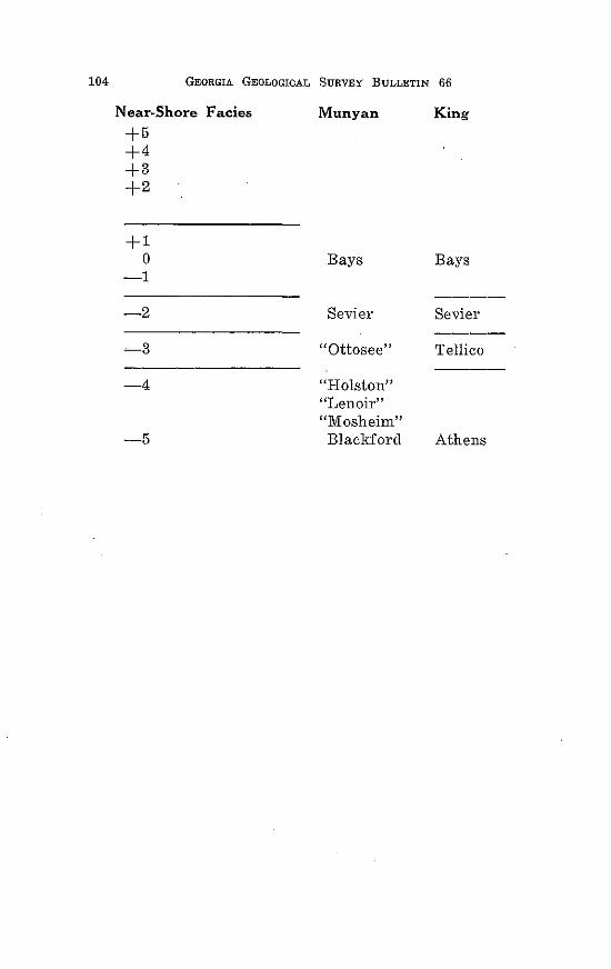
104 GEORGIA GEOLOGICAL SURVEY BULLETIN 66
Near-Shore Facies Munyan King
+5 +4 +3 +2
+1 0 Bays Bays
-1 ----
-2 Sevier Sevier ----
-3 ''Ottosee'' Tellico
-4 "Holston" ''Lenoir'' "Mosheim"
-5 Blackford Athens
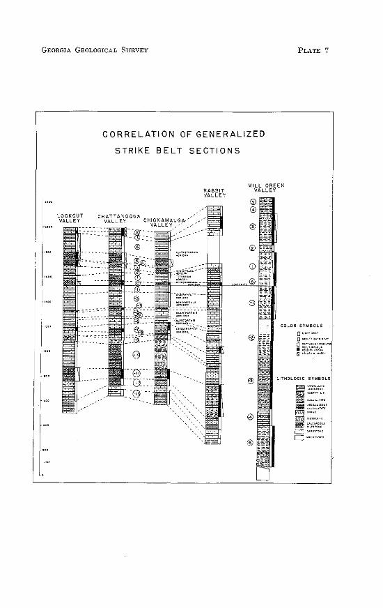
GEORGIA GEOLOGICAL SURVEY
1"0
CORRELATION OF GENERALIZED
STRIKE BELT SECTIONS
MILL CREEK VALLEY
PLATE 7
COLOR SYMBOLS
0'''"''"" 0 ""·"'"""'""'
~ :::;:;:·~~~:t"" lSI""'""""''
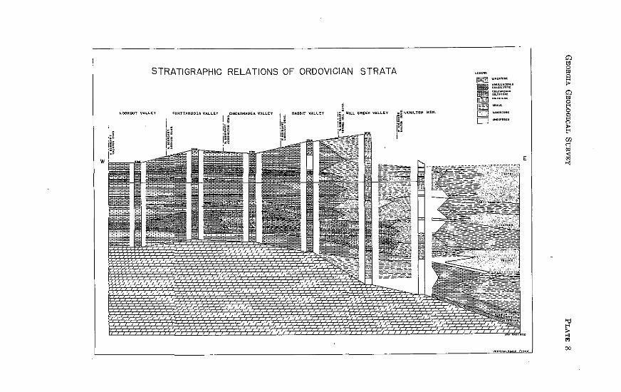
STRATIGRAPHIC RELATIONS OF ORDOVICIAN STRATA
~OOKOUT VA~~(Y I lHICKAMAUGA VAlLEY
ill ~~rAMILTON MTN.
(~
CHATTANOOGA VALLEY
E
.......
SELECTED REFERENCES
Allen, A. T. and Lester, J. G. (1954) Contributions to the Paleontology of No1·thwest Georgia, Ga. Geol. Survey, Bull. 62.
Bassler, R. S. (1932) The Stratigraphy of the Central Basin of Tennessee, Tenn. Geol. Survey, Bull. 38, p. 268.
Butts, Charles. (1926) Geology of Alabama, The Paleozoic Rocks, Ala. Geol. Survey, Spec. Rpt. 14.
Butts, Charles (1940) Geology of the Appalachian Valley in Virginia, Va. Geol. Survey, Bull. 52.
Butts, Charles (1948) Geology and Mineral Resources of the Paleozoic Area in Northwest Georgia, Ga. Geol. Survey, Bull. 54.
Cooper, B. N. (1941) Athens Equivalents Northwest of Clinch Mountain in Southwest Virginia, (Abst.), Geol. Soc. Am., Bull., vol. 52, p. 1893.
Cooper, B. N. and Prouty, C. E. (1943) StTatigraphy of the Lower Middle Ordovician of Tazewell County, Virginia, Geol. Soc. Am., Bull., vol. 54, p. 819-886.
Cooper, B. N. (1945) Stones River Equivalents in the Appala.chian Region, Jour. Geol., val. LIII, p. 262~275.
Cooper, B. N. and Cooper, G. A. (1946) Lower Middle 01·do"Vician Stratigraphy oj the Shenandoah Valley, Geol. Soc. Am., Bull., vol. 57, p. 55.
Fox, P. P. and Grant, L. F. (1944) Ordovician Bentonites in Tenness-ee and Adjacent States, Jour. Geol., val. LII, p. 319-332.
Hayes, C. W. (1902) The Rome Folio·, U.S. Geol. Survey, Geol. Atlas, No. 78. Huffman, G. G. (1945) Middle Ordo"Vician Limestones from Lee County,
Vi1·ginia to Central Kentucky, Jour. Geol., vol. LIII, p. 145-174. Kay, G. M. (1937) Stt•atigraphy of the Trenton Group, Geol. Soc. Am., Bull.,
vol. 48. Kay, Marshall (1948) Summary of Middle Ordovician B01·dering Allegheny
Synclinorium, Amer. Assoc. Petrol. Geol., Bull., vol. 32, p. 1397-1416. King, Philip B. (1950) Tectonic Fnvmework of SoutheastMn United States,
Amer. Assoc. Petrol. Geol., Bull., vol. 34, p. 635-671. McFarland, A. C. and White, W. H. (1948) Trenton and Pre-Trenton of
Kentucky, Amer. Assoc. Petrol. Geol., Bull., vol. 32, p. 1627-1646. Munyan, A. C. (1951) Geology a'/1./.l Mineral Re·sources of the Dalton Quad
rangle, Georgia-Tennessee, Ga. Geol. Survey, Bull. 57. Neuman, R. B. (1951) St. Paul Group: A Re"Vision of the "StoJWs Ri"Ver"
Gt·oup of Maryland and Adjacent States, Geol. Soc. Am., Bull., vol. 62, p. 267-324.
Prouty, C. E. (1948) Trenton and Sub-Trenton Stratigraphy of Northwest Belts of 1'irginia and Tennesse·e, Amer. Assoc. Petrol. Geol., Bull., vol. 32, p. 1596-1626.
Raymond, P. E. (1920) Middle Ordo"Vician of Virginia and Tennessee, (Abst.), Geol. Soc. Am., Bull., vol. 31, p. 137.
Rosenkrans, R. R. (1936) Stratigraphy of Ordovician Bentonite Beds in Southwestern Virginia, Va. Geol. Survey, Bull. 46, p. 85-112.
Ulrich, E. 0. and Schuchert, C. (1902) Seas and Barrie1·s of Ea11tern NoTth America, N.Y. Museum, Bull. 52, p. 633-662.
Ulrich, E. 0. (1911) Revision of the Paleo·zoic Systems, Geol. Soc. Am., Bull., vol. 22, p. 281-680.
Wilson, C. W. (1949) Pre-Chattanooga Stratigraphy in Cent1·al Tennessee, Tenn. Geol. Survey, Bull. 56.
INDEX
Abstract_ 1 Acknowledgments ---------------------------- 5 Algae ____ 24, 81, 86, 92, 99 Allen and Lester________________________________ 5 Am,plexopora coh~mbiana ---------------- 50 Ancist?"o?·hynca sp. -------------------------- 79 Ancistro1·hynca costata ____ 19, 74, 83 Archeorthis sp. _ __________ 62 Artlwoclema annat'tm1- -------------------- 83 Atactop01·ella sp. --------------------- 50 Angustoce?·as sp. ------------------------------ 52 Bathocyp1·is cylindrica. ____ 93 Bathyu1·us sp. ------------------------------------ 80 Batostonw sp. ------------------------ 79 Batostom,a inr-plicatu?n -------------------- 62 Batostonw magnapora ___ 54 Batostoma n~inneso-tense ---------- 59, 62 B atostoma 'Va1-um ________ 59 Batostoma winchelli ---------------------- 59 Benchmark 120 Section ---------- 28, 33 Bentonite ______ 1, 6, 9, 10, 11, 13, 14,
15, 19, 26, 28, 30, 31, 32, 33, 34, 35, 36, 37, 38, 39, 40, 41,
44, 45, 63, 64, 65, 66, 102 Bethel Church Section -------------- 34, 39 Butts, Charles ---------------------------- 5, 103 Byssonchia sp. -----------------·----------·---- 52 Byssonchia intm·ntedia ------------ 52, 57 Calliops callicephala ------------------------ SO Callopo1·a and1·ewsi ----------------------- 51 Callopora dalei ------------- ------------------ 51 Callo2Jora d~~malis __ ------------------------- 54 Callopo1·a goodhuensis ______ 54 Callopora nu~ltitabulata ---------------- 59 Callo2Jora pulchella -------- ----------------- 99 Callopo1·a 1·amosa ____ -------------------- 51 Callopo1·a ?'a11WSa va1'. ntgosa -------- 51 Callop01·a sigilla1·oides -------------------- 51 Callopo1·a subnodosa ____ ------------------- 51 Ca/nta?·otoecltia sp. ------------------ 19, 22 Chaetetes sp. -------------------- --------------- !19 Chattanooga Valley 1, 6, 7, 47, 48,
49, 50, 53, 54, 55, 58, 60, 61, 63, 64, 66, 67, 68, 71, 75, 78, 80, 81, 82, 83, 84, 86, 88, 90, 91, 92, 93, 95, 96, 97, 98, 103.
105, 106 Chickamauga Creek Section ---------- 29 Chickamauga Valley ______ 1, 6, 7, 47,
48, 49, 50, 53, 55, 58, 60, 61, 63, 64, 66, 67, 68, 71, 75, 77' 80, 81, 82, 83, 84, 85, 88, 89, 91, 92, 93, 94, 96, 97, 98, 102,
103, 105, 106 Colttmna?·ia halli ----------------------------- 73 Conclusions ------------------- ______________ 101 Constella1·ia sp. ______ ----------------- 51, 54 Constella1-ia florida------------------------- 51 Constellaria 2Jrominens ------------ 51 'Constella?·ia varia ------------ --------------- 51 Cooper, B. N. and Prouty ________ _ 5
Cooper Heights Quarry Section 41 Cooper Heights No. 2 Section .. 41, 42 Co1·nulites flexus C1·yptophragm,us ant1quatus 79, 81 OryJJtozoon ___ . --------·· 99 Cyclospira sp. ---------------------------- 87, 89 Cyclostomice1·as cassinense _____ 93 Cy1·toce1·as sp. ---------------------------------- 52 Cy1·tocm·as vallandingha?ni ------------ 52 Daln1-anella sp. ---------------------------------- 79 De·kayeUa sp. ------------------------ 54, 73 Dekayella p1·aennntia . ------------------- 87 Dekaye'lla ul1'ichi . ---------------------------- 51 Dekayia aspM'a ------------------------------ 51 Descriptions of measured sections 6 Desm,o1·this nevadensis -------------------- 87 Dictyonella reticnlata ----------- 87 Dinorthis sp. ---------------------------------- 93 Dino1·this atavoides 83 Dipleu1·a dekayi _ ----------------- 93 Dole1·oides gibbosus ------------- 87 Dug Gap Section -------------- 11 Eridot1·ypa sp. -------------------------- 51,~ 54 E1-idotrypa mutabilis ---~------------------ 51 Escharopo?'a sp. -------------------- 65 Escha?·op01·a falciformis ---------------- 51 Escha1·opora snb1·ecta ______ 92 Et~1·ydictya ntultipo?·a -------------- 73 Fasci{e1·a subca1·inata -------------- 62 79 Favistella sp. ...... 73, 76, 88,' 90,
92, 95 Favistella halli ------------------------ 73 Favosites sp. ---------------- 73, 76, 79, 81 Finkelnbu1·gia sp. --------------------------- 99 Flexicalyntene sp. --------------------------- 52 Friendship Church Section 26 Furnace Creek Section ------------------- 12 General geology of area __________ 4 Glypto1·this sp. --------------------------------- 93 Glyptm·this bellantgosa _________ 81, 83 Glypto?·this insrntlpta ---------------------- 87 Goniocwas sp. ------------------------ 93 Gonioce'ras anceps ____ ----------------- 87 HalloJJO?'a dalei _ --------------- ______________ 51. Hamilton Mountain ------------------------ 8 Hayes, C. W. _____ ------------------------------ 4 H ebe?·tella sp. . ....... 17, 54, 62, 65,69,
70, 83 Hebe?·tella bm·ealis _____________ 51, 54, 62 Hebe•J"tella f1·ankjo1·tensis _____ _48, 51,
54, 57 Hebe1·tella occiclentalis ______ 51, 54, 57 Hebertella sinnata -------------------- 48, 51 Helicotoma tenne·sseensis ---------------- 93 Helopora sp. -------------------------- 73 Helopora spinijo?·ntis _______________ 83, 87 Hem,iplwagm,us i1nperjectus _________ 87 Hesperorthis sp. ---------------- 65, 87, 97 Hespe?'o?·this t1·icena1·ia 17, 71, 72,
73, 74, 79, 83 Hete1·otrypc~ frondosa ---------------------- 51
108
INDEX-(Cont'd)
Heterot1·ypa parvulipm·a . ------------,. 51 Hog Jowl Creek Section ------------------ 38 Homotrypa sp. ______ 51, 62, 69,72, 73,
84, 88, 89 HomotJypa cincinnatiensis 51 Homott·ypa cnrvata _ 51 Homotrypa curvata var. praecipta 54 Homotrypa cylindrica _ 51 H o1notrypa flabellaris ------------- 51 Homot1·ypa g1·andis ____________________ , ___ 51 Homotrypa minnesotensis --------- 83 Horrwt·rypa obl,;qua ______ _ _______________ 51 Homot1·ypa subramosa -------------------- 62 HoTmotoma sp. ------------ 52, 57, 59, 99 H o1·moto"nta bellicincta -------------------- 99 Honnotoma gracilis ------------- 62 Horn Mountain Section ---- 13, !5 Idiostrophia sp. ---------------------------. 87 Introduction 2 Jsochillina sp. ---------·········-- 59 Jsochillina nelsoni ----······ ----···-- 57 Jsotelus sp. 74, 76, 80, 82 Johns Mountain Section ···-···- 13, 15 Lambeophyllum p?·ofundum ········- 70 Leca.nospira sp. ---·-··················-··-- 99 Leperditia sp. ··--··--··-- 59, 62, 80, 82 Leperditia fabulites .... 57, 80, 84, 87 Leptaena sp. ···-·------------- ---··········-···· 48 Leptotrypa cla11is .............. 51 Lichenaria sp. ···-···-·-- ---------·········- 99 Lingula sp. ---------------------·-···· ----·------- 95 Liospira sp. --·········-··- 52, 55, 7 4 L~osp~ra 'fr:OfJne_ -------···············-- 7£ Lwsptr·a vttruvm ...... _ ----------·-······· 8 1 Location of area -----------·-··-------··-. 2 Lookout Valley .... 1, 6, 7, 26, 47, 48,
49, 50, 53, 54, 55, 56, 58, 60, 61, 63, 65, 66, 67, 68, 70, 71, 72, 75, 76, 77, 79, 80, 81, 82, 83, 84, 86, 88, 89, 90, 91, 92, 93,95,96,97,98, 103,105,106
Lophospira sp. 55, 59, 62, 69, 74, 84, 89, 99
LophospiJ·a bowdeni .......... 52 Lophospira medialis ------------------- 70 Lophospi1·a. serrulatus ...... __ 80 Mach~1·ites sp ............ _ ------------ 87, 99 Maddox Gap Section ................. __ 30 Master's Pasture Section ---------------- 12 Method of Zonation _____ ............. _____ 5 Michelinoce1·as :::p ........ _. ------------------ 52 Michelinoceras· multicameTatum _ 91 Michelinoc·e·ras sociale ------------------- 87 Mill Branch Section --------------···- 40 Mill Creek Section ----------------· 10 Mill Creek Valley .. 1, 7, 15, 21, 63,
101, 103, 105, lOS Mimella. melonica _______ ------------------· 87 Monot1·ypa intabulata ........... _.. 51 Monticulop01·a sp. 96, 97, 99 Morganville Section 44, 46
109
Multicostella sp. ------------- S3 Munyan, A. C. ---------------------------·-- 5 Near-Shore Facies .. 5, 6, 8, 101, 103 Near-Shore Zones .... ---------------··- 16
Zone +5 ---------------··-- 16 Zone + 4 ----------------·---·- 16 Zone + 3 ________________ 17 Zone +2 _______ --------·· 17 Zone +1 ---------------- 18 Zone 0 ------------·· 19 Zone -1 ---------------- 20 Zone -2 _______ ....... -------------··-· 22 Zone -3 _________________ 23 Zone -4 _______ ....... ________ ____________ 24 Zone -5 -----.,.......... 25
New Hope Church Section ......... __ S Nicholsonella sp. __________ 87 Offshore Facies 6, 26, 103 Offshore Zones
Zone +8 47 Zone + 7 ----------------- 48 Zone + S ------------------ 50 Zone + 5 ---............. ------------··-- 52 Zone + 4 ---------------- 53 Zone + 3 -------------- ------------------ 55 Zone + 2 _______ ....... ------------------ 58 Zone + 1 --------·····- 60 Zone 0 ------------------ 63, 66 Zone -1 ---------------·--- 67 Zone -2 ______ _. ......... ---------------·--· 71 Zone -3 -----------------·-- 75 Zone -4 ------------------ 77 Zone -5 ------------------·-- SO Zone -6 ------------·---··- 82 Zone -7 --------------·-· ------------·----··-- 84 Zone -S ________ ------------· 88 Zone -9 --.,............. 89 Zone -10 ·--------------··----·-- 91 Zone -11 ---·· -----------......... 93 Zone -12 -------------·---·- 96 Zone -13 ....... ----------------------· 97
Ophileta levata --............. 87 OrthooMras sp. ____ 55, 62, 66, 70, 7 4,
so, 84, 95, 97, 99 Orthorhynchula sp. ----··- 17 O-rtho1·hynchula linneyi ............ 19, 51 Oxoplecia holstonensis 74 Pachydictya sp ...... _____________ ......... 76 Pachydictya follatar 62, 65 Petigophora sp. _______ . _____ 48, 51 Phragrnolites firnbriatus ----·-- SO Pigeon Mountain ........... _ 35 Pionodema sp ... _________________ 74, 81 Pionoderna rninuscula ____ 79, 93 Pionodema subaequata 74, S3 Platys·t1·ophia sp. ------------------ 17 Platystrophia actttilirata ----------·-·-- 48 Platystrophia colbiensis --------·-··- 51 Platyst1·op-hia colbiensis mutatar .... 51 Platystrophia crassar -------·------------··- 51 PlatystTophia elegantula ______________ 51
INDEX-(Cont'd)
Platyst1·ophia juvensis -------------------- 51 Platyst1·ophia laticosta ------------------ 51 Platystrophia pondm·osa ---------- 48, 51 Platyst'rophia p1·ecu1"BO?" ------------------ 51 Platystrophia st,rigos«- -------------------- 51 Platystrophia sublaticosta _____________ 51 Platyst.-,·opltia t?·entonensis ------------ 57 Pleasant Valley Section ----------- 27 Plecto'rthis fissicosta --------------·-- 48, 51 Plectorthis plicatella ______ --------------- 51 Prasopo1-r1; sp. --------------------------- 51, 83 P1·asop01'·a hospitalis ------------------------ 48 Previous work ----------------------------- 4 P1·otozyga sp. ----------------------------------- 89 Rabbit Valley 1, 6, 7, 26, 47, 48,
50, 52, 53, 55, 58, 60, 61, 63, 64, 66, 67, 68, 69, 71, 75, 77, 80, 82, 84, 88, 89, 91, 93, 94, 96, 97, 98, 101, 102, 103, 105, 106
Rafinesquina sp. ___ 65, 69, 70, 74, 93 Rafinesquinct alternata -~---------------- 51 Rafinesquina, deltoidea ------------------ 91 Rafinesq~~inct minnesotensis 87 Rafinesqu..ina, t?·entonensis ______ 62, 79 Raphistoma sp. ------------------------------- 99 Raphisto?na pe1·acultum -------------- _ 93 Raymond ____ -------------------- ------------------ 5 Resserella sp. ___ ------------------------ 87 Resse1·ella rogata '--------------------------- 87 Rhinidictya sp. ____________ 54, 62, 70, 76 Rhinidictya 'rnutabilis ____ 59, 62, 65,
81, 83, 92 Rho?nbot?·ypa sp. ____ ----------------------- 69 Rhynchotre~na sp. ------------------ 59, 62 Rhynchotrem,a argentu1·bie1'Jt -------- 62 Rhynchotrema capax -------------- 51 Rhynchot?'e?na i?w?·ebescens __ 19, 55,
60, 61, 62, 69 Rhynchot1·ema minnesotemsis ________ 19 Rocky Face Section ----------------------- 10 Rost1·icellula sp. -------------------------------- 93
Rost1-icellula plena -------------------- 87 Rost?-icellula ?'ostrata ---------------------- 99 Sibulites subelongatus -----------------·-- 70 Sib~dites sp. -------------- ----------------------- 99 Smith Gap Section -------------------- 31 Solenopo?·a sp. ---------------------------- 24, 82 Solenopm·a compacta ________ -81, 86, 92 Sowe1·byella sp. ---------- 19, 22, 72, 73,
74, 83 Sower·byella pnnctostriata ____ 79 Stictop01·ella sp. ____ --------------------------- 83 St1·eptelasma sp. _ ------------ 62, 69 Streptelasma prof~tndt~m, -------- 66, 69 St1·omatoceritLm sp. ------------------------ 61 St?'omatocerium pustulosum __ 57, 62 St1·omatocerium ?'Ugosum ______ 62, 79 St1·ophomena sp. ----------- 65, 81, 87 St?·ophO?nena incuTvata ____ 74, 79, 91 St?·ophomena planumbona __ 74, 76, 79,
82, 87, 95 St1·ophomena tennesseensis ____ 91, 93 T. A. G. Railroad Section -------------- 36 Telephone Line Section ---------------- 34 Tet1·adium sp. ---------------------------- 59, 87 Tet?·adium celhdowwm -------------- 57, 79 Tet1·adium columnan _______ 73, 81 Tet?'adium fib1·atum ________ 50, 57, 58,
59, 62, 69 Tet?·adiu?n syringopo?·oides ____ 81, 87 Trenton Section --------------.. _______________ 44 Ulrich ------------ ____ ------------------------------ 5 Ulrich and Schuchert _ ------------------- 5 Union Section ------------------------------ 44 U. S. Hig·hway 11 Section ------------ 45 l' alcourea sp. ---------------------------------- 93 Valcou?·oce?·as sp. ________ ------------------- 52 Voiles Creek Section -------------- 37 Zygospi1·a sp. ______ 51, 65, 74, 89, 91 Zygospi1·a modesta 17, 52, 62, 65,
69, 70, 74 Zygospij·a ?'emwvi?·ost?·is __ 19, 52, 55,
65, 69, 70, 74, 79, 82, 83, 93
110
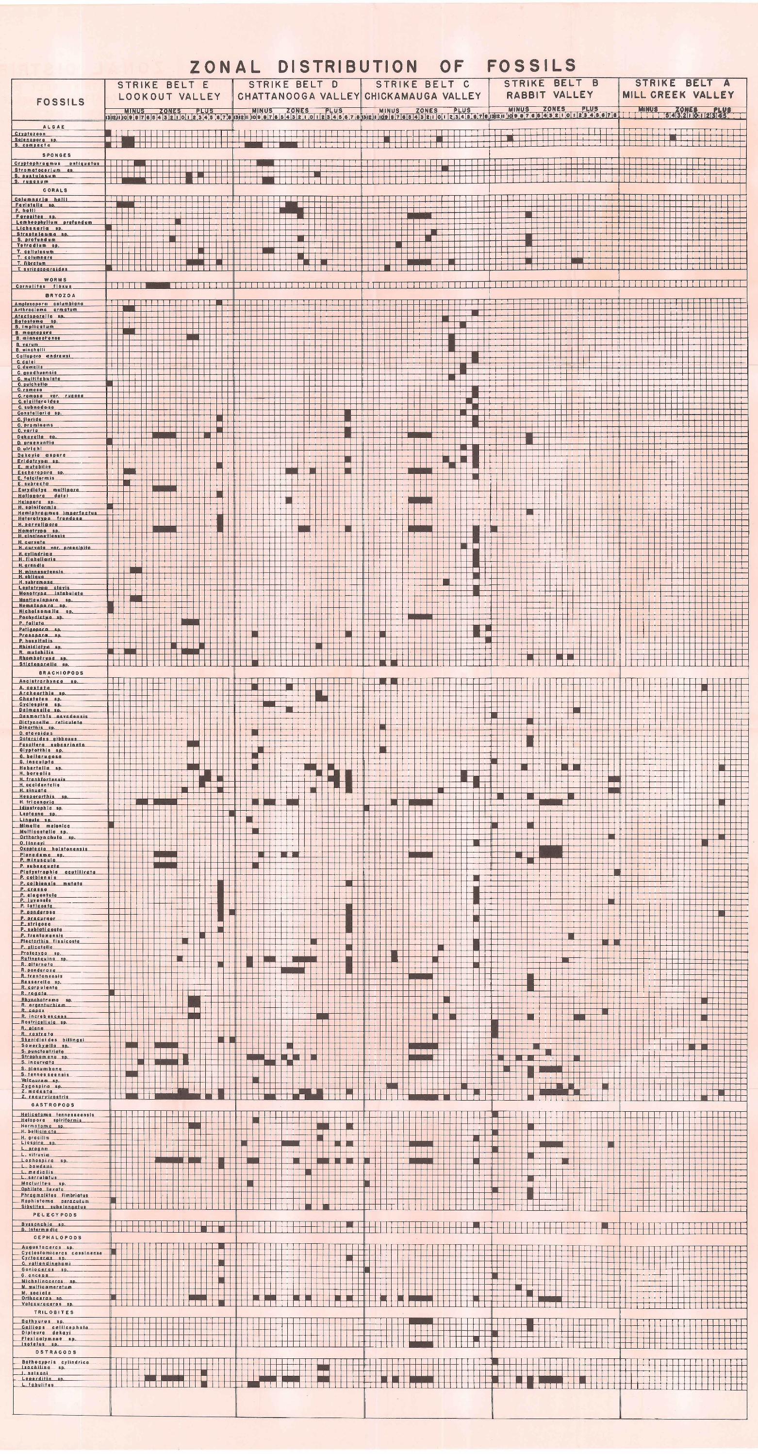
FOSSILS
ZONAL DISTRIBUTION OF STRIKE BELT E LOOKOUT VALLEY
STRIKE BELT D STRIKE BELT C CHATTANOOGA VALLEY CHICKAMAUGA VALLEY
FOSSILS STRIKE BELT B RABBIT VALLEY
STRIKE BELT A MILL CREE I< VALLEY
MINUS lONt:S PLUS ~M,INUS ZONES PLUS MINUS ZONt:S PLUS MINUT P'LU.
ALGAE Crwotozoon Solanoooto •• s. comoocto
SP ON GES
Crwot ooh• a am u • a ntla uo tua Sttomataculum •• s . ouatuloum s ....... ..
CORALS
Columnotlol ho lll ....... , F I II &D. Lam boaohvllum •••lund um
-I I
-T I
l
• ........... ~
~ ..... 1.
S. o<olundum ' I t~Tr~···~···~~~~um~~···==========~=Etl=EEt~~:EEi~~~~~~~~j;--~=E~~~=E~=tfj=t~=tti~~-tj=t~~ti:tij:tij:tij:t±3~ ~ T. ooll I• om -
T columnon j j j ·~ T libtotum -T ••• , •••• .,.aldoo I I
I I
I I I I I
-wt OR M S
Cotnuldoo floaua I I I I l i T 1 I 1111 I I I 1 I I I I I I I I I I I II I I I I I I I I I I I I I I I II II 1 1 I I I I I I I I I I I I I I I I I TITTTITT T T I I I I I I
BRYOZOA ............ , .......... . Atth roclo mo o rm otu m Alaclooarol l o B• B. Imp!
a. ••••
I
I I I - -
, i
• • a."''""""''""'" . '"'""' 0. wlncho l Co ll aooro andtowol C. do l o!
c . ......... ,. C multllob•loto
• 0 '
.11~1·10 lli:llllg.·;m,tmlllm' II I I
Eochorooon oo. - -E. tolclfotnnlo
H. oorvullmoro HomotrJDa
H. •••
M oo Ind o le• H . llobollo '"' H. arondlo " olo .... • ••
Ahlnldloha A mutoblllo Ahombooo • Stlctoootollo ••
' ...... '.
I i -
I I
I •
-
I I . I
: 0 ! - •
i
I
t · • • I
. ,-++.+++-+-1-
I
• I
• - ·
!- l -+---l -1 - ' - 1--~ - 1--l- .J-. .J-.-1---l-
•
--
~~~~··*:.,;~:~0
~000111~1
;,,,~~~~~~I~HI~~~H~·f~~~~i§I--J.i§It~-irri~B~~~~i~ - t''-H+-'H- I- I- • --"- "'"".;. -4+f-+++++-++-H++-+++- ·~ .• H. occ ldontallo ! i - ! H. oinuoto -. o <•••••••thlo i i I • "· •••••nnr lo - - - • ! •
. . •. ,. . .. • Uno ulo • 0
!- -- • ! I - 0
-II -
; '
• Mlmo llo molan lo o Multl co otollo •• Otthothvn oohulo •• 0 .,
Oxooleclo holotanonolo
__ ,__ -
~-r~-rtt-rrr~-rt~·r++r+-r~+~~-+-H-++-'~+-+~+-+~·~~-r++-r~+- --h---t-+-+-+-1--J-.-;. ~ -H---1---l-+++-+-l++++-l• --H",_,_t-+-1
'"' 0 •• P. mlnuoc •ulo P. oubooo.uoto Plotvott oo hlo oc u t II I rot a
P. colblonolo mutata
A chotromo •• W A ~ J--
_R, l ncroboocon• -Roolrlcoll ulo ••-R
_R rootro to Skonldlol doo bolllnoo: s ..... •• "• 00
~=~·-· ~-~to ~··~o l~ott~··=========t~~fj~~~~~ Strooho o • S. l nou,.mlo .. s ........ , •••• •. tonn o•· ··· ·
GAST'ROPODS
Hoi' :otoo !nolo l olooo .• ""'''
Hormotom•o ••. eta
H. o roc lll o
••• L oroon "
lo o , ;,
--
"" i r o • o ---bowdoml mo d l o lll o ..... loltuo
Mo cl,.llo 0 oo.
Phroomollit., flmho lno"" Roohlo.tomo " ' Slbui!Oo "" lonootuo
PE L E CY PODS
• noon o h,lo
+ -+-+l-1--1--ll -- ~ -
•
-•
B ln tormodlo I I I I I I I I I I ITITT~I~I I I CEPIHALOPOOS
Auouotoceto• on C•clootomlc•··· , •••••• n •.
C. v o II a odin o hom I Gonloc oroo • • G. oncool
• M.
•
•
I I l
1-·
-
I I I I -• -
•
• ---
• •
I I II II I
I-- __ , - •
-I I I
I II II I I I I
M. ooo l olo
~~Ortlth~D>~oc:lo~or~ou~ol~o~======~f+~~++~~~~~~~tj~~~~~~~~~tl:~tl~·-tii~~·ti • j- Vo lcouroootoo •• I I I I 1 I
TRILO B I TES
Bothvuru. • •. Colll ooo oolll•, oh Dl o louro doko•l . , 00 ........ ..
OSTRACODS
Both I I I I I I Tl I l ooch Ina oo I .I
--'~·~~ouw; o;~· u_ __________ ~~~_L~-~~-~~~~_L~~~--Li~L}~~fi--~ L j 11 L tobu ll t.. I I I I I I I I • :wTIJ::
I --I
IT T
I I I I I I I I
:
•
I
!
! . ' ---t--H---r+ f -
• I
• • •
•
I I
• I ' I I I
I
o I
0 0
l
I I I II I I I I I I I I