Embed Size (px)
Citation preview

PLAT OF .081 ACRE TRACT FOR GROVER SKAGGS ltJ6-A N t:. rry ldt• c/ 7} r?ft;,
Situated in the City of Logan, Falls Township, Hocking County, Ohio; being part of Lot 473 of the Churchill, Little and Bishop's Addition to the City of Logan as recorded in Village Plat Book 1, Page 55, Hocking County Recorder's Office; and being part of Section 11, Township 14, Range 17.
NOR.IHWEG.T L.ORtJER.. DF LDT 1173
NORiHEAST u.J ·. or= LOI a WESLEY 4- N\"~GARET o r: BREE.2E. 8 r'1 144 .. 1\3 b z Lor 413 Pt.
~i~'l5 '1tl"Wi· 2.4b' ·r-----____ s_~s· 3a" E. 4~,q(~I T DT f\L
SCALE:
1" = 20'
;.,,, ~ a :r
I
uJ
REFERENCE BEARING:
41,0Q' --e---
LEGEND:
G:iRO\JER :H.J\G6S 201..\ - 3\"
.01bl P\l.RES LDT l1 T3 Pt.
1-\lLE.'~
o 5/8" iron pin with 1~" plastic ID cap set
• 5/8 11 iron pin with plastic ID cap no. 6044 found
o 1" OD iron pipe found • 1 " iron pin found 6 7/8" iron pin found • 1/4" OD iron pipe found
-0 "J
6 '-0 M r
a' Lll p [L-
I-cc w u
SOUTHtASI CORtU.R OF Lo·r t-17 3
REFERENCES:
Tax maps Deed descriptions Previous surveys Existing monumentation Platted subdivision
P.pproved · Mathematicaliy Hocking County Engineer's office
BJ r-..J)ate.2-:J.2._-;-1 ;p
The West line of Lot 473 of the City of Logan as North O degrees 00 minutes 00 seconds East.
I hereb~ertify that an actual survey was made under my supervision of the premises shown hereon on the 7th day of May, 1993 and that the plat is a correct representation of the premises as described by said survey.
liegis~~£.k6344 Survey by: Larry P. Gerstner Engineering and Surveying
119 West Main St., Logan, Ohio 43138 385-4260

SURVEY DESCRIPTION OF .081 ACRE TRACT FOR GROVER SKAGGS
Situated in the City of Logan, Falls Township, Hocking County, Ohio; being part of Lot 473 of the Churchill, Little and Bishop's Addition to the City of Logan as recorded in Village Plat Book 1, Page 55, Hocking County Recorder's Office; being part of Section 11, Township 14, Range 17; and being more particularly described as follows:
Beginning at a 5/8 11 iron pin set at the Southwest corner of said Lot 473, from which a 5/8" iron pin with plastic ID cap no. 6044 found bears South 6 degrees 13 minutes 00 seconds East at a distance of .65 feet;
thence with the West line of said Lot 473 North 0 degrees 00 minutes 00 seconds East a distance of 40.53 feet to a 5/8" iron pin set, from which a 1" OD iron pipe found at the Northwest corner of said Lot 473 bears North 0 degrees 00 minutes 00 seconds East at a distance of 37.17 feet and a 1" iron pin found bears North 86 degrees 15 minutes 30 seconds West at a distance of 2.46 feet:
thence leaving the West line of said Lot 473 South 86 degrees 15 minutes 30 seconds East a distance of 98.94 feet to a 5/8" iron pin set on the East line of said Lot 473, passing a 5/8" iron pin set at a distance of 47.00 feet and from which a 7/8" iron pin found at the Northeast corner of said Lot 473 bears North 8 degrees 55 minutes 00 seconds East at a distance of 29.12 feet;
thence with the East line of said Lot 473 South 8 55 minutes 00 seconds West a distance of 33.42 feet to OD iron pipe found at the Southeast corner of said Lot
thence with the South line of said Lot 473 degrees 20 minutes 50 seconds West a distance of 93.55 the point of beginning containing .081 acres more subject to any public or private easements of record.
degrees a 1-1/4" 473; South 89
feet to or less,
The above .081 acre survey is intended to describe the South half of Lot 473 of the City of Logan as deeded to Grover Skaggs, deed reference Volume 204, Page 316, Hocking County Recorder's Office. This survey was based upon information obtained from tax maps, deed descriptions, previous surveys, existing monumentation, and a platted subdivision. The reference bearing for this survey is the West line of Lot 473 of the City of Logan as North 0 degrees 00 minutes 00 seconds East. All iron pins set by this survey are capped by a 1-1/4" plastic identification cap. The above described property was surveyed by Larry P. Gerstner, Ohio Registered Surveyor No. 6344, on May 7, 1993.
Approved • Mathematic(!\ly l-1c:c\;iri1 County fr.P,1~.:~1\ ,:'1f1cc . r .. , §"~/'2.Jf J
' 7P !'} .JJ ~~--u' <!Jl~~,p· ~ 0 &: 0 -:~ _q_Td;' _:_ __ :. ___ ~----1-~~;.~·· .. ·····:: ~ ~1,.l •.O· ii()~ \ .::: : LARRY P. \ ~ • \ GERSTNER 1 t"4 ~~ <~ \ S-6344 ~ I
Survey by: ~~ •.";),.,.. n~l Larry
119 West
. ~· ...... ~a, ~1~¥.• ~ ·~ P. Gerstner - Engineering and Surveying ~. & ~····~······o ~,.,. Main Street, Logan, Ohio 43138 385-4260 ~~~"'.:: l)Vf.'t~,?\~
> .,,,,·".;.:17n;:4l~=e

=-------......... .-...~ ,..~ ......... '·.· ·\:\,.
.. ~. \, . I
' "-" \ • ! I
; \. •·
. I 0.3,.,.. , . . .. . . ·. .., --~ ............ ··7··:;, ... - :>
/ ,/
!0/~c>i~ ,,,. ':.f
/lif'~~41(.J ' ~ { .. .....,"'< r ___ _
4?1 480 • 1."l'f·
i
. ! ' i' l' ... :.141 ... Vr'. ~---·--
... d te.t 1'1P
,: i
' 1,,
G I

UAM.Cd '08/iliOAI
18 .Yuo<P 18*47)
A/or.e: difA~/A/6:$ ~IVi!O ,--,ro,u p~~"'""' ..,.~~ lfJ.,/OA~l! FV~ Ol!rl!.e .. ~4fOA.I o,r AAK:U~.!S
• .rr
Evc;t?oA~llMEAJ r /,(jXJ I
((G,5 1
ALLEY
,{/~OCC> ~ - /07, e6 1
R&".CREAICctS : £J.eea~ At:JMorEo aw.vrv rA>< MA~ PR4V10V:S &teV.SY..:S
.e"JCl.5 7'/A/6 AIONUM.e.Or~
/.£65VD
LO<N G1ry i.IJrJt 1/11 Tfllf;U 'IS
N• Pr.
' ~")
~ . ....__...
~ ~ I
' ~ p
~ S·Pr.
~:....,
~)
)
8- 6/8 11/,«JAIPIA/6c/w/;,o.~.dP t.SrAMPEO 11.:::;JeYMOUK-~ ''
0-IKOAI P/A/ F'OOA/D
@ -AXLe Pol/NO
•-P01Nr
6.e1A/G ,l.or.::5 Alo, 481-# 48e 1'° 7?-lc 6TYor=LOG4A.I--- cSec77oAI II -Tl3·Al--!'e4Nee l71W--FALLB 70wAf.5HIP- /la:k/A.J5 Coo,v7Y
<.5mre oF0/110,

"": f, ';] .-.. . .~t:-• ·}_.
'.) ~ 1 > ~ ~ : ~· ' ~ ' . ' \
'J .. . ~ : ~ ~. -. i. . l .
' • ,,, • t. ~ \ -; • .. •
. . , 'j ,.} __ ,
(
l i
- \J"\

I l ---·
Scale l" = 2 ~ · Date J l-14 ·B '5
\...... '<l lJ
~ </)
< ()
~ I; ...
.. g:;
""" '9
N Q
N ... IVl
"t •' 0
~
Q: .rRo}.) PIP~ Foo/I.JO
0 -: J:R~ Pl>J FOi.JUD . ::
I' ,• '',• ·.
··:· '·~ '
,~.s&'
FAJ...LS row>Jsµ1p' HOCKJAJ~ ColJAJIY) OHIO. .·
Lor~ 171+- t94PT~
Hocking County Recorder's Office- Plat Book
D<U..D Volume ·q C> Page ~e4
., , Jf>
40
/(,' 0''
· 1 sro~"-' FR A ff\ e J.\O'J.S €.
7' 11 '1
''-'°a"
±Asoq.111g s~.rr. ! .. ltnS At
. ,5,ol' : w t- /\, ~t?e& ~e ' I+\· II~
' '
t • ~
,
We hereby .certify that the foregoing plat was prepared from an actual survey of the premises. . No side line of the principal building is less thM, dimensions shown. Iron pins are not set unless shown, thus ... o -~ · For mortgage loan and title insurance purposes only. Ct:..~TJF 'I ro BAPG01-110« l'\OR.'fCoAG,€. .
. co ... ~ 01-lro &~2 · T/ft,t ;::1J$µ/ifq.J,~ w . ... '" ' ' ' . .·· ".·::~ ' . \."':.
WILUAM R. SHAW &'ASSOCIATES INC.· .. Consµltlng Engl nee rs & Surveyors 63 W. Main St. Logan, OH 43138
(614) 385·4349
l~f.."'° "V .;"'_..ft'"r""y#tf'~ 1(0 '•., '-.'.~ "\• \ ,,.;~\ ·,;;::' -• 1
,;,,.._ ...
'--~~~~~~~~~~~~~~~-


lOG/IAI ~1ry PLNr Oli' .167 ACHE 1'RACT FOR JIMMIE BAHNES (f~ !Is t I) Lo-rt/IO 1'1)
Situated in Falls Township, Hocking County, Ohio; being 55 feet off of the East side of Lot 4'10 of the C.W. James Addition to the City of Logan as recorded in Village Plat Book 1, Page 46, Hocking County Hecorder's Office; being part o! Section 11, Township 11~, Range 17.
L . J A Ct G 0 ~ H E: 1\HJ \ 6 E.. R I q I -- 12 2
t\I 9 0 I] 0 0 \ 0 D II E - 6, 5 I 00 t
:TIMM IE ~ ' TrtER ESA BAR~JE5 ~ \\J LOT i110 PT Q
a .... (\') ' Ln -..
. ) 6 7 ACRES t'J "1 ~ -
UJ ' .. l.lJ ;>-.... C) .\..
~ C) ~ .. ~ a
CJ ... <t:: I,) ~ ~ "' ~
~ C)
VJ
--- ~'-------------"1.J' 5 ~Of)OD'DO"W - 55,00'
THIRD ,STREET l/0.26'
SCALE:
1 11 = 20 1
~~ 0 10 !lO
LEGEND:
o 5/8" iron pin with 1-1/4" plastic ID cap set
HEFERENCES:
Tax maps Deed descriptions Previous surveys Existing monurn.entation Platted subdivision
REFEHENCE BEAHING:
Plat of the C.W. James Addition to the City of Logan~
A~p~c·rcd - Mithem:}tic~\IJ
llcc;i!na Count; Er.ginm's oflic~
a1f // 4 w DJte 7 -/r-S
I hereby certify that an actual survey was m~de under my supervision of the premises shown hereon on the 14th day of July 1988 and that the plat is a correct representation of the premises as described by said survey.
Survey by:
~~e~d~~~a_.~~~~_,,__..,.._ Larry P. Gerstner - Engineering and 119 West Main St., Logan, Ohio 43138

SURVEY DESCRIPTION OF .167 ACRE TRACT FOR JIMMIE BARNES
Situated in Falls Township, HocKing County, Ohio;· being 55 feet off of i h e Ea s t s i d e o f Lo t Numb e r 4 10 o f th e C • ~J. Jame s Add i t i on t o th e C i t y o f Logan as recorded in Village Plat BooK 1, Page 48, HocKing County Recorder's Off ice; being part of Section 11, Township 14, Range 17; and being more particularly described as follows:
Be g i n n i n g at a 5 /8 11 i r on p i n s e t at t he Nor the a :S.'t c or n e r o f Lo t 4 10 o f the City of Logan; thence with the East line of said Lot 410 South 0 degrees 00 minutes 00 seconds East a distance of 132.00 feet to a 5/8 11 iron pin set at the Southeast corner of sai.d Lot 410; thence with the South line of said Lot 410 South 90 degrees 00 minut~s 00 seconds West a distance of 55.00 feet to a 5/8" iron pin set; thence North 0 degrees 00 f(linutes 00 seconds East a distance of 132.00 feet to a 5/8 11 iron pin set on the North line of said Lot 410; ·thence tJ i th the North 1 ine of said 1 ot 410 North 90 degrees 00 minutes 00 seconds East a distance of 55.00 feet to the point of beginning containing .167 acres more or less, subject to any public and private easements of record.
The above .167 acre survey is intended to describe all of a partial Lot 4 10 as deeded to J i mm i e and Theres a Barnes , deed reference Vo 1 u me 185 , Page 842, HocK ing · County Recorder's · Off ice. Th is survey 1;1as based upor1 information obtained from tax maps, deed descriptions, previous surveys, existing monumentation, and a platted subdivision. The reference bearing for this survey is the plat of the C.W. James Addition to the City of Logan. All iron pins set by this survey are capped by a 1-1/4 11 plastic identification cap. The above described property was surveyed by Larry P. Gerstner, Ohio Registered Surveyor No. 6344, on July 13, 1888.
Survey by: Larry P. Gerstner - Engineering and Surveying
118 West Main Street, Logan, Ohio 43138 385-4260
Approved • Mathematicatry Hocking County Engineer's office
By-!/ffuL-oate 7 -/ S:-80

~ Lo ;hJJ (, I TY PLAT 01 .1625 ACRE LOT 506 01 THE CITY OF LOGAN FOR MARC AND CYNTHIA RICKETTS
(,,.OT )()~
Situated in the City of Logan, Jalls Township, Hocking County, Ohio; being all of Lot 506 of the Churchill, Little, and Bishop Addition to the City of Logan as recorded in Village Plat Book 1, Page 55, Hocking County Recorder's Office; and beifig part of Section 11, ·Township 14, Range 17.
I~ LLE Y
Lr, (°) LS)
s .. j
~ CJ
I'<! \'\ CD f11 'Q
I
'.c
"""' ~ (j)
~ ~ l..\J LU :
C)
_j C)
._) w
Cl C'.)
~ 0 \} C,)
~ ~
< ClJ _j
w.J
2:
DI\ VI D .. ~· K£LL E 'I MIL STED 10lf - l/36
N q D \I 00 t 0 D N £ - 5 3 , 6 3 ,
MARC & CY~JT~J IA RIC~£TT5
I 6 l/ - 6Cf 6
LOT ,506 . I 62.~ ACRES
N '1 ovoo' oo·· W - 53. 63'
Tft/R..D STREE·T
... ~ ~
\'4 (<1
\
h. (j)
~ QJ
~ ~ ~
c c:::i !:>
CJ Vl
I'
~ ~
3 ~ N N
I
' ~
~
N ~ ~
I C')
tr'
~ LU ~ ~ -':X: C:O
<t: ~ ...j
~
SCALE:
1 11 = 20'
0
LEGEND:
o 5/8" iron pin with 1/4" plastic ID cap set
Tax maps Deed descriptions Previous surveys Existing monumentation Platted subdivision
HEi"'EHENCE BEAIUNG:
The plat of the Churchill, Little, and Bishop Addition to the City of Logan •
I hereby certify that an actual survey was made under my supervision of the premises shown hereon on the 5th day of February, 1990 and that the plat is a correct representation of the premises as described by said survey.
Awoved • r~hthematicaH1 l'rckin" C1•.1·r 1
11 E'·' :~"··-'<: c·r' 8y~iJ''-) .I" ·~~~~~qo
Survey by: Larry P. Gerstner Engineering and Surveying 119 West Main St., Logan, Ohio 43138 385-4260

SURVEY DESCRIPTION OF .1625 ACRE LOT 506
OF THE CITY OF LOGAN FOR MARC AND CYNTHIA RICKETTS
Situated in the City of Logan, Falls Township. Hocking County. Ohio; being all of Lot 506 of the Churchill, Little, and Bishop Addition to the City of Logan as recorded in Village Plat Book l, Page 55, Hocking County Recorder 1 s Office: being part of Section 11. Township 14. Range 17; and being more particularly described as follows:
Beginning at a 5/8 11 iron pin set at the Northwest corner of Lot 506: thence with the North line of Lot 506 North 90 degrees 00 minutes 00
seconds East a distance of 53.63 feet to a 5/8 11 iron pin set at the Northeast corner of Lot 506;
thence with the East line of Lot 506 South 0 degrees 00 minutes 00 seconds East a distance of 132.00 feet to a 5/8 11 iron pin set at the Southeast corner of Lot 506;
thence with the South line of Lot 506 North 90 degrees 00 minutes 00 seconds West a distance of 53.63 feet to a 5/8 11 iron pin set at the Southwest corner of Lot 506;
thence with the West line of Lot 506 North 0 degrees 00 minutes 00 seconds East a distance of 132.00 feet to the point of beginning containing .1625 acres more or less, subject to any public and private easements of record.
The above .1625 acre survey is intended to describe all of Lot 506 as deeded to Marc and Cynthia Ricketts, deed reference Volume 164, Page 696, Hocking County Recorder's Office. This survey was based upon information obtained from tax maps, deed descriptions, previous surveys, existing monumentation, and a platted subdivision. The reference bearing for this survey is the plat of the Churchill, Little, and Bishop Addition to the City of Logan. All iron pins set by this survey are capped by a 1-1/4 11 plastic identification cap. The above described property was surveyed by Larry P. Gerstner, Ohio Registered Surveyor No. 6344. on February 5, 1990.
Awoved • Mathematically Hocking County Er.r-::~o:r's l.': _
By KPN ~~~'.J "J..~t."1E ..
Survey by: Larry P. Gerstner - Engineering and Surveying
119 West Main Street, Logan, Ohio 43138 385-4260

\ JI - \,_,' ' - .
,/b·s4LLEY . /€.o.88'
Lor No.484
/ao. oo' '8'~&t1Nt:. ~e;~/n/d;j' Wt:1//
- .
';
,--_
·{_ ' - ' o.88'
Fence 7~ §69' .":-:.:~ ~./Bo > 51/£ V£Y dr THf WEST /OOrEGr'
~~----H=t,_-"""!2.a"7"..&.&~~%~"!:..~~rr . OF L.Or No, 180 IN THE C/TY OF ,.,__-----4-,~ /.OGll'i COUNTY OF HOCK/N~
.)/AT£ OF 01110
#r-TH/5 5UK.V£-Y rs 6i.U~5TION/l!}l-E 5££ rtAr$ f PlE"Gt>>
_SI/RV£ YEO 2-IG-'G \" rr--'---~-::-:~ir-:-~~~~~-.-~~--.:111~----L~~·~~~9-/~-------- ~
'II::=:::~- - - ----------- - - - -- -- -. by /l//ROLO P- W/11/LEY ~\°\' _ llTllEN~ 01110 'I'~ ' ()
. \l) ~
:<a' (AS,PHA~r)
--.---~-- - - - - ----- -
0/,, /Jc._£'- '~ ,~·-u--f(_j "\!, -?v~e:<.t_"-1 \)"-
REG. Sl.IRV£YO£ if.986 \\ C lll/£Cll ST,
'

_nL___~C= /\__ ?A:?~ Qi:=
/-\~~<~ ~. I c::::)j'-\~
I I ~o-_n:.-\'N c.~~ =~ a;:- _,/-C)~
~ ~.Ao.-::; o,e- "'...::::::: ~.'"2-£J-'<:LL.1.-, ~~ / ~ ~ Ab-':>. "-rC' ~-\.C: c.::LI-/ Cl=-~~
""1. '- 5. c...r::-:.=v~
'-...fOL. ::;:2..\-C, 1 ~- 2:>(~
l
I ·----------------
9~-...: ~. -:=:,- ?~. 1-6
'V~"<'--S :CJ,__;-.__-,- ~ -. ) c~-. --S""
D~~ (,A__-s ..A-L=~~)
0. &Q._s1-'...Q~~
'-./C);_. \I A ' \==t:-. 29. I c -:s;l'>(_p-) ,~ .... ~ "'1~"'>"':-1 J C).:;2..{ .~. ~ ~-) ..__ -
9... L .s. "'1 .~::.:"!:>~
YOJ-, .20.i:;-, ~. 3\:-S
0 )o
I I
(~·)·o-.::h:))
0 , 12· .:L~ ?'~(_~') w ( ~ CA. ..... . ,,-~ ~(_~.)
A~0-c:- ~ !C\C\A. I ,~_y:
~'~~ ~'~~~~:-~?-~~~~- ~~~----- ) ________ ___;

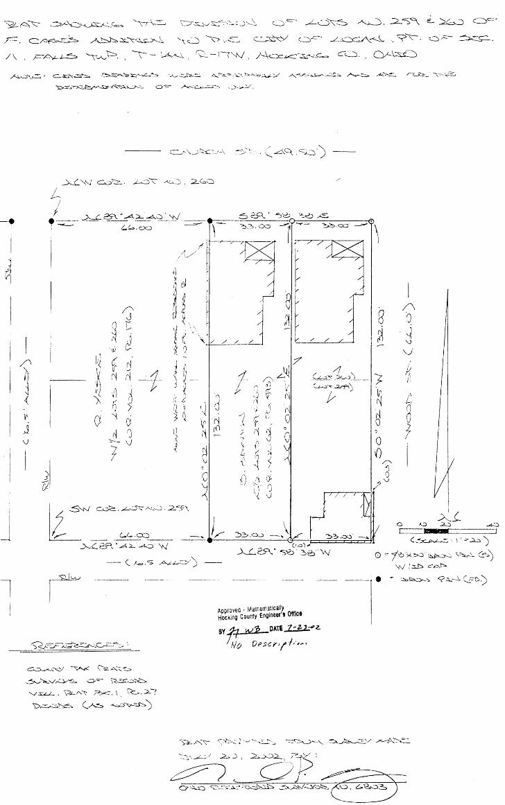
DESCRIPTION OF SURVEY FOR MR. DON ALLISON
Being the premises last transferred in Vol. 221, Pgs. 66 &
645, Hocking Co. Deed Records, situated in In-Lot No. 179 of the
city of Logan, Falls Twp., Hocking Co., Ohio, and more particularly
described as follows:
Beginning at an iron pin set on the north line of Lot. No.
1 79, said pin being referenced by the southwEsterly corner of Lot.
No. 485 of the Churchill, Little & Bishop Addition to the city of
" Logan which bears N 81 14' 45" W a distance of 100.00 ft.;
" Thence, with said north line, S 81 14' 45" Ea distance of
74.57 ft. to an iron pin set;
Thence s 0 25' 31" W a distance of 43.70 ft. to an iron pin
set.;
Thence, with the north line of a tract transferred to the city 0
of Logan in Vol. 8 2 I Pg. 409, N 89 55' 46" w a distance of 73.78
ft. to an iron pin set on the east line of a tract described in
Vol. 218' Pg. 375; 0
Thence, with said east line, N 0 25' 31" E a dist.ance of 54.96
ft. to the place of beginning, containing 0. 0836 Acre, more or
less, and being subject to all valid easements.
Cited bearings were arbitrarily assigned and are for the
determination of angles only.
All iron pins described as being set are 1/2 11 X 30 11 with an
attached plastic identification cap.
The above description is the result of an actual survey made
by Michael P. Berry, Ohio Registered Surveyor No. 6803, on August
30, 1994.
/h_uflP. Michael P. Berry
~A~ ~D~.:_<--= "\/\.:=.._. D~...1..:,.::..L-;_'.._c..J'--~ C::y=-- ...L-0~~ ~. 2~ E-~ ~c=-
F. c:::::~ A~~"'\:--~~ ~Q ~ :,,..::::.__, c.;s.:;.~/ c.::i..c-- ~~ ~ y'\:-. a,.:::- ~.
/\ \ !--~~ ~\':::::>.\'-\--\..A.,<--\.\ <\)_-\c"+J, )~~-~~-~ c~., Q./-\~
..A.Lo~ - C::..~"-:.::s"::::,.. ~--~:J;::.__..._-..::__«::> ,_..__,~_...=:.:. <>.,.I-""-""·:..::\ 1>-r.-.:<;;-_;_v_Y A-v':~~--: ... :::s::,. .A..--'.:::::.. ~~~ r~ "1-~
l I
~~-""~~\., 0"='" ,A..~:.:.::;~ CJ-:.<-~).
rl
~t A --f I ~ 3 if ~
\~ > 1.[ ~
\} ~ lQ
I(' ~ I) I\ 1> \)
~ 8 ~
CJ
~
~'-'¢/ ~ \>.2..A'\;_~
--~--)';,.._,./,.::Y~ 0-'="" S<...::r::ot>~
'-.../':s;:,/.....L._. y..L..A"'\: ~-· \' \.<:.:,. 2..(
'L>~~ (~ ~~)
/'
1 . /:\_£,~ j/
'.' {) \/
-J ;~ ~ N . r) ~- ('~
~ 1 f 0 r<I :; ~ ~
'J
- '-; 0 ~ {' l r' ~ \ ~ :'\.. )
{) rl rj '0._ <J i~ \)
)~
Approved . Mathematically Hocking county Engineer's 01flca
/
/ /
(,L_y~1--~'l___ ;. (~'"'..2.J'<f'\)
~ -~
'8
0 {)
(~·-)".:.-~)
0 =-f10'>'-~"~ ~~'-- <:s.) W(~CAJ:'::>.
av ff w :e DATE ..1..;.J;J_ ~ z.
; 0 DPscY1/ .;,.,,,..,

''51
: ' 1!,, 1·1 '
i (
i,
, I
J
! /
,'
,f...
(.\
~ ~ ~ ·~
~
\}) ~
'
4.5'
C\ ~ " ' ()
~ ~ ~ ~ "~·
'~
d..J-,
~' ·~~
"" ~ ' ~
~ (
'
'
t_(::J6'///<I ? 17}/'' rc,,//f; I/ , l t?/- z. '12 r'f-.
D .:1~ I/, 1? rl~r6'

5 ~~-..J A ~r---:.~~~ ,..--....,, '\'•1 ,--, /\ ........ '----/-~ \, /-~~-T·-~
~~ ..J-'<--3\. •"-::::-
:S:::·---~ -=:-::.::~-_c:-_ . ) \ \ 1=---/'---..J-~-:.~~ -\:::u__., \-->. . \ --f A..>---J. . v -1 (".f\/ I /---\oc.<...:S:.~ CQ. ,
;::::..~-.,.~"'--C.,"' ·-~'"'--' - ,..L.__j-~~- "<s __ ). ~-1~_ (__y-::.-- --\:r \;=----. ~0 G'=- .-L'~~~ A..~
A 'J>c.::~--. <.. . i-- ····- -, -- .._ - , ,_/ < \.. '-._)~ ";;:::;,___ - . ~-~. ·-- "':-..... ..-<:: /"...' .)'... ./ ..... :----- /:--, -~ ±c'i.'.'. y /'--"... '- - . ~-... f-- .. •. _ ___,...____C\..__) .,--;.. .. /'-.... _.:... .. ~ /---..:__: -- -< ./.--'=>·• ~-.......::::. I __ 7,.-~_::-,. ~ '- - ~- - ~ --
~" 0 ' j
""')
/./
l n 0 2, I
1
( u-2 .,.::::i_::i .. .-:r
18 0j r{';
; r
cf)
i?J
~ fl
~ 1f· I d 1'-j 1 IJ , ...... t (\~ ~ 1 8
(\ I (
.) {\ 0l '(
{ r,J ... -" -~ v 1 r: ~.I :J 0) ":/1 '\{ (j
~ 0
i ,,/~-»-- (---=.{~. Q--.:) --~
>. .. ..L ... 2>-~ -~~ .. -<';"°~ w
.... i
I
\l .--1
I I
l ________ _ ( ' . ~ ' " I ...... •/) --- y _ _, .- :J ,."'-'J...,_-_L .. ....:.,_./
~
8 ~ '1 1.1
~ i~
~ ~ /.. I I
~ ~ ~! r ('1
({1 J IJ
0 ()
n 0 () I I . ,... _____ ------------·
I
i
0 I
-----~bL ___________ _
I
l _______ ~~-
>Li .70 .....d8 oo·
ttrr MFtrl .. · · - - - =~.:l
~=- ·. ) . =-40·\ 0 ;:,, J~..:i ·,X.-:o ~~ oi..~c..~) ~If." ~~~- ~ ~b :S\.:1"«"-l'~
I' /-'~b ...S-&6.::>_~ •I
_'-/_·;:s;.J..L_ , "-;;x _ _,t:.\_"'-.. ,?:_~. l I ~?- ,,, 2 -, ;____ °.26
IJ_,..,3..:::.:}:.z.::, (A---~ .x..:.;,.·::J<:.:;-..:~,Ii::~)
I I I

"-1- --- ) A_,x_:, ' \ )
Q --\: 'N /-\..c:.s=K-~ C:u . \
QI--~~)\
Lex-~--~-
QF~- '\,J-\;::-, c__~ GA--
) \. c_ , . '-__ _:_;,
A...'t-'~~~--.,.;_-'-_;_\J_f- _\. -- \·. _ ____) ··- 'C ~\.:==· C"'~~</ e. _ _1°:-- --"'::: __ '---_)C-, ~-.. i (_ "-l~_i._ . ~~-~~ F-=:.,k::__ . \ 1 ~ • 2-C ~26)
/
-· __________ J
-----1 c;,_ . E_ _L.. . C.r-"-.,-=.2..:.-,. .. s~
~.:::i .c,:::: ' ~-'=> I Q_). =:'::> :::,-T
...L-=~ -~:.-r::>:> ~"'-::-.
. . .::'("
I (
0 ,,.(::) .:;.::> ~ t===:=lllfiil ... IK:=:::==:=:::::'.::=::3-
(_ s c_.p. .,1 • =- ·- ) -~J •)
L __
0 =-1'6"X?--~· ~ ~::_G)v_)\A· d 0 "-'-"'_,,.,=:_. ~ C'.A."'-~
' '_,J--:r-\-=;_~ ~ -G '6::.::l.::::S
~ ~ EB =- )'-~· 'J-.'?:.-:J. ~"=r---'- ?~ (~-v. 'i ~\:;) A> ~-:.C~"'v~-:..~
J (GL. =~~> \ -·---0-~--3>~. °A. ~-,._ , ~'-==~------..:0===-...L:'".:;:::=>--· .==2:5::...K~-----_-_ ..... ---'
.....,_____ -s 6C\ " -s-s. 4.L\·w. °' q. ~~ . ----/ t
~I 5~~ c~:::i2:_. ...L~ .. ::5""~. ....2:::1 ~
(_ F ..k'.Y--\.. ... L<:::::5-, 6-2> J
C;-\,ulc:c:=.r-\ -S~. ----
(_AC\ . "SC)')
-~---~- -------
__ C~~ \~ 9..LA~
~~-?~ o~ v~ .. ::r-~ '-i~. ~ .. u:·,~ ~-. \ S.'G.l( ~2.:o
______ v~ (/'-...~ ~::J'-.C'-:::.)
v
G /~~~'.)£:.
0 • ,.. ~-~ }?--~""' 0~)
\n
=·'-==> <,>;o:::<.>w"S'">~C:.'::. ~~~ . 0"30'~
~
,.\-,,, ,.,'!'' ..•
,,,.

THIS PAGE
LEFT BLANK
INTENTIONALLY

I ,., ri~vr tJj/Ui~AL
i : ! '
I
(7 40) 385-4349
//PP1!7cd ff ~06/?1~ REcc;RkcP ;/'/
///i. t.//.l6t: /Z14r .b7cc:J..<- <I M-: ss~/r/ ~/" L. t'/6///~ F14~L.S TW~
:SCCr/O/'J //~ //'(/(/'RI?~
//oc1<1,A./? Cc;c.Nv-rr 0///0
QdT{
7 -1 t., ·o I ~&1-lff{_§l:
~.I.~. _,,_:Qfl__./_:
0$0 IL
I ,8'/15/..5 er £~d/1~YN6~ /f 77!c e, t//'16° &'/" f8ft/ .5~ A/, //~J/ 'c:>/ ''S ,4,.Vp /J' ~
8£ C/.~c·v /CR /1¥E £?CTc/C/'?/l'/tl?TlttJ.-I C'r ""1«<5<:8' ~#'~ Y.
.. ~~ ~ (I
() : z -
RErcRb/CCS; REC'cifiO· ?LAI Tl?K PcAr ?.a:-v1~d.5 .5'v£v~J<t
VJ (\)
J rO './)
1-4
8 fJ ~
:i (]
cY.. 1-1
·- -- . '-~r 1-7~
..,,; - .... "'· .. ~ ·- ... .._ ..
~ <(. r-1 t
~-- ..
11 ;f'-1 "" I
I
i
1 ...
J
-¥- ApprovQd !.y -tlie ('-Ay
Se.'f"•/1C.e. 0 ,- reCA·.-)r
-See. de.ed OR 2 (9()-233 3-3-0'3
C:~t!'iE/'-/£):
A: '";~Al' 'x--.7~ "I. P;tl )¥. ?t.ASrlCc/IP
-5/"/fi?PEJJ ''--5-Er/V/~</.e ,t-/l~cc: "...fET
--------
I HEREBY crnTIFY THAT THIS PLAT WAS Pf~EPAf~ED FROM AN ACTUAL FIELD SURVEY OF THE PREMISES l~J -,/u/Y'~ OF 2001 AND FROM EXISTING PUBLIC RECORDS AND THAT SAID PLAT CORRECTLY SHOWS THE
LIMITS OF THE PARCEL TO BE CONVEYED.
THIS ()2_ DAY OF _QcTa/?:,~ p_' 2001.
GEORGE~ SEYMOUR /
t\ p D r D \ c u · M at h e m d t 1 c e:!i 1 y H o c k :' u ~ J u n t y E ri g i n e er' s 0 ff : c e
OHIO PROFESSIONAL SURVEYOR NO. 6044
©2001 SEYMOUR & ASSOCIATES '.'- -11---~Ji __ OAH: _ip__-:Ze>J

EXHIBIT "A" 6499.2 SQUARE FEET
Being a part of the tract of land that is now or formerly in the name of Ralph and Ellen Davis, Trustees, as recorded in Official Rec-0rd 110 at page 348, Hocking County Recorder's Office, said tract being a part of Lot 472 of the Churchill, Little and Bishop's Addition to Logan as recorded in Village Plat Book 1 at page 55, said tract being situated in the City of Logan, Falls Township, Section 11, T14N, Rl 7W, Hocking County, State of Ohio, and being more particularly described as follows:
Beginning at an iron pin with an "X" cut in the top found on the Southeast comer of Lot 472 of the Churchill, Little and Bishop's Addition to Logan on the North right-of-way line ofHunter Street;
Thence along the North right-of-way line of Hunter Street, and the South line of Lot 472, North 79 degrees 03 minutes 56 seconds West a distance of 71.55 feet to a 5/8" X 30" iron pin with a plastic identification cap set;
Thence along the West line of Lot 4 72 and the East line of Iron Street, North 11 degrees 51 minutes 07 seconds East a distance of 81.97 feet to a 5/8" X 30'' iron pin with a plastic identification cap set;
Thence with a new line through Lot 4 72, South 81 degrees 12 minutes 17 seconds East a distance of 84.40 feet to a 5/8" X 30" iron pin with a plastic identification cap set on the East line of Lot 472;
Thence along the East line of Lot 472, South 20 degrees 20 minutes 34 seconds West a distance of 86.27 feet to the point of beginning containing 6499.2 square feet, more or less, and subject to all easements of record.
All 5/8" X 301' iron pins with plastic identification caps set are stamped "Seymour & Associates".
The bearings used in the above described tract were based on the East line of Iron Street as bearing, North 11 degrees 51 minutes 07 seconds East and are for the determination of angles only.
The above described tract was surveyed by George F. Seymour, Ohio Professional Surveyor No. 6044, in June of2001.
Approved - MathL;n;;ii'.;a;lv Hocking County t.r1~1118t:i 's (Ji!u:;

EXHIBIT"A" 4245.6 SQUARE FEET
Being a part of the tract of land that is now or formerly in the name of Ralph and Ellen Davis, Trustees, as recorded in Official Record 110 at page 348, Hocking County Recorder's Office, said tract being a part of Lot 472 of the Churchill, Little and Bishop's Addition to Logan as recorded in Village Plat Book 1 at page 55, said tract being situated in the City of L-Ogan, Falls Township, Section 11, Tl4N, RI 7W, Hocking County, State of Ohio, and being more particularly described as follows:
Beginning at a 5/8" X 30" iron pin with a plastic identification cap set on the Northeast corner of Lot 472 of the Churchill, Little and Bishop's Addition to Logan;
Thence along the East line of Lot 472, South 20.degrees 20 minutes 34 seconds East a distance of 47.48 feet to a 5/8" X 30" iron pin with a plastic identification cap set;
Thence leaving the East line of said lot, North 81 degrees 12 minutes 17 seconds West a distance of 84.40 feet to a 5/8" X 30" iron pin with a plastic identification cap set on the West line of said lot and the East line of Iron Street;
Thence along the West line of Lot 472, North 11degrees51minutes07 seconds East a distance of 50.00 feet to a 5/8" X 30" iron pin with a plastic identification cap set;
Thence leaving the East line of Iron Street, and along the North line of Lot 472, South 79 degrees 03 minutes 56 seconds East a distance of 91.31 feet to the point of beginning containing 4245.6 square feet, more or less, and subject to all easements of record.
All 5/8" X 30" iron pins with plastic identification caps set are stamped "Seymour & Associates".
The bearings used in the above described tract were based on the East line oflron Street as bearing, North 11 degrees 51 minutes 07 seconds East and are for the detennination of angles only.
The above described tract was surveyed by George F. Seymour, Ohio Professional Surveyor No. 6044, in June of 2001.
Approved - Mat11~m;:;t1cd,fy Hocking County E.r1~111fi 0 r s Of1ice

,'
•
I n,qp' PRe:P~RC:D F4()1f f3eRrH,q HR/'111..TON , "fre.s,nlet<l I" •
G10UNC1L'-CrrY or: loa/ltt S bt2w1ap·/71/r lnJmc""dd/tf f'6wlh o/'Lr;~ 46'6, ~r4wl11d, J/dcof1a11, 1n
Pal"!; l.s Rdftlee1fD'd - !11dt.cai-'d:.ty k#Q'tcr /IPctJ. //ho Jno~ln! rr-Paf ftJ '1~ &ra#i1'd f'o C<Ju11c1 £ ~?'a/ L<XJt?n 1J:: J3~rlha llam1 /fon ft;r 011 /Ille; 1'1 /Jeu af 11 (3Cb. - /11Jieofetl Pf /dl/~rs f}e rG . .Survz 17 (I: W. .$eo/Jnth1 dca1, I ':.LI) ' L tKJ?1ndl11"a 1'10~/, 23 ;94--=1,,~ _ ____:____c_...:....:_______;;.._....;....;;.._...;..,.j.._ ........


/)~ CJ1 f.1'tJ If
l/&..ff~A<..d
Motion by Bright sseconded by Cooley that reports be accepted and placed on file.
Vote- All voted yea. Th~e f~rro~~ng ordinance read. 'l' vacate .Pa.Pt of alley between West St. and Iron St, between Third St. ard S ...-=in=-tl1e City of Logan, Ohio. Motion by Eastman seconded by Cooley that ordinance be passed. Vote- All voted yea. A number of vistors were present represented by Mr. Christ~an who requested
council that a levy be placed on the ballet this fall for recreation purposed for the city of Logan. five thnth mill.
Motion by Bright seconded by E stman that the solicitor be instructed to prepare the necessary legislation that this might be done.
1 Vote- All voted y~~. f3 v-t- D~ottltTJ(,· Mr. Fred Murry present representing the Logan Foundry and Machine Co and 01!1 N"' T informed xouncil thn.t the Logan l1""ound1'y and Machine were building an addition to
0
their plant and requested council for permission to extend their sanitary sewer to Bowen St, at no cost to the City • ·
'11he .. following resolution was read. . ,. :. , A. :r:;,~~:,<;>lution of the cl ty of ·Logan, Hocki~~\'~9~~mty :~hio,. grantiDg permis~im
t9, .. the ~o~~~~~J._f9~ndru and ... M~?hine. Go~ to ~ay ~ con,.~;~;RM~t ana maint~in a San! tary Sewer fl:"o~~'~if~.s~-cproperty~<_f:\(>buting Front .• St. Sou~~~fJ:Jr%~nd unden th._~ alley ~~~uting upon 1 ts :'·said property and extending south bet·weenllota 464 and 465 to the z s~riitary se•~r in Bowen Street,
· ?.!otion by DeU1,~lo ·seconded by Eastman that resolution be passed • V9te- All voted yea. iwlOtJon by Meldrim seconded by Deissele tha,t'. O.rdinance to vacate 95 feet
off of the': east end of Mineral Ave. of said city immediately west of the west line of Walnut St. be reconsidered. ·
Vote- Hone yes, Meldrim yes, Cooley yes,-Eastman no, Brie;ht no, Delssele yes.
Motion carries. Shall t~e Ordinance pass. Vote- Hone yes, Meldrim no, Cooley yes, Eastman no, Bri3ht no, Deissele
no. Motl on lost • .Motion by Meldrim seconded bJ Deissele that the east ent of Mineral Ave.
be opened up and graded and made passable. Vote- All voted yea. A petitic;m w~a read signed by a mumber of citiz~ens living in the west
end of the city for a street light br erected at the corner of Bebty Ave. and Third St.
Hefferd~ito the Street Comm. ~otion by Bright seconded by Deissele that Mr. hloore be excused. Vote- All voted yea. · ~otion by Eastman seconded by Bright that Council adjourn. Vote- All voted yea.
-.1 .•• ·

Deaoription of Allay For Whioh Vacation is Requested by Bertha Hamilton
Being the East part of the allay imQlediataly south of Lot 486
as tha lots are oonaeoutively numbered in the City of Logan, Hooking
County, State ot Ohio, and further desoribed as follower Beginning at
a orosa out in the alley oonorete header on tha West line of Weat Street,
and at the South East oorner of aaid Lot 4861 thence South with the said
west line of West Streot 16.6 feet to a aeoond orosa out in the said
allay oonoreta haaderi thenoa with the south line of the said alley im
mediately aouth of Lot 486, North 81 degrees - Ol minutes West 134.88
feet to an iron pinJ thonoo North 16.5 feet to a oroaa out in the oon
orett' driveway and on tha north line of aa.id allay immedia.-toly south
of Lot 4881 thenoe South 81 degreaa - 01 minutaa East 134.68 feet along
aaid north line to the plaoa of beginning, oontaining .050 Aorea.

Deaoription of Tract to bo Granted to City of Logan
by Bertha Hrunilton for Use as an Alley
Being a part of Lot 179 as the lota are oonseoutively numbered
in the City of Logan, Hooking County, State or Ohio, and mora partioularly
deaoribed as follows• Beginning at an 1.ron pin in the aouth Una of tho
all«3y immediately South of Lot 486, in said City of Logan, said iron pin
being roferenoed by the following, tho south east oorner of said Lot 486,
whioh is marked by a orosa out in the alley oonorebe header, bears North
16.6 foet and South 81 dogreoa - 01 minutoa East 134.ea foots thonoe
from tho said iron pin beginning point, South 33.55 teet to the North
line of Churoh Streat; thanoa with the said north line of Church Stroet1
thenoa with tho said north line of Churoh Streat, North 89 dagreea •
15 minutes West 16,5 feet, to a oross out in a briok foundation; thence
North 2 degrees • 15 minutes Woat 38.18 feat to the said south lina ot
the alley immediately south of Lot 4861 thanoo with the said south lina
of the alley, South 81 degrees • 01 minutes East 18.10 feet to the be•
ginning, containing 1013 Aoraa.

--· --· --!"-·---· ~. -. -
\~ILLIA~ R; SHAW, P.E .. P.S.
: ;:SEORGi;: F'. SEYMOUR. ~.S.
Seymour-Shaw ~ Associates, Inc. Consulting Engineers & Surveyors
PHONE
614. 305-4349
~J')\t.I::; A P~:r <0F J...LS> _ _.Aft). >] B
a;::: >Jl.ES c:s:r1 t.JF~ .1~~w > -~·:,.,;:..c.,,.> l
l tJG-/11'1 CIT'( ptflLS II
615 WALHONDING AVE.
LOGAN. OHIO 43138
Y-'A,Li ... 'f-.; ··-pAJ P ,.\-:r ~··~\_;,~ > 52_ .. _ ) .... t'l{ J-l <J::.K:\i"-1C:> C:..i.~:>.
C))l..~~
~--r,--'N~~(-~~ ,'-, ~--~-... -. -----~---~~:;s;--- ---------- --- --- -------- ---------1' ~ ~
I l
--I
'
·r ___ ·'• ~
-T9Ac~ I
6.~6<:'.l~.38 Ac~.E~~
( 9J. ~vo,c. <iC\ ~. 1.);<(..>)
•woved ·Mathematica.Uy Hocking County ngine81's Offita "-JlJ-· _ ate .fi.::z:$ 2.
>.LoT"I";. ~ Z;"" .. J: .. P.:s,•l(,,,...'$ ""r.A.K.1-'.:;<.! F"r!'l,7.-\,. PP,e;:v~
.-:;..v/l;,;lii~l ,At-.;.i::> ,\1°:';:..r,. l""t?R. ,r.;c1~;1).,11::s,<..1.tir.r;I:t.:..N.

Seymour.,Shaw S Associates, Inc. Con6ulting Engineers & Surveyors
. W!Ll-IAM R. SH.AW. P.E .. P.S.
~e'.OR?.~ F\ sa;YMO~,R. P.S.
PHONE
614. 38!5-434Q
615 WALHONOING AVE.
L.OGAN, OHIO 43138
Desdription of Tr~ct of Land from Verna Collison
to Mary Schrader
B~ing a }?art of the tract of land transferred to Verna Collison
~s iecorded in Deed Book. 99 at page 320, HocJ<ing County Hecorder • s
~-Off{be, paid tract being a part of Lot 178 to the ~ity of Logan
sitqated in Section 11, rr14N, Rl 7W, Falls Township, HocJdng County,
;State of Oh.io, .and more particularly described as follows:
Be9i.nning, for referencf3, f)t the~ southeast corner of Lot 1 78 to the City of Logan on the west line of West Street;
'rhertcf# with the west line of West Street, North 0° 09' 10° East
tance of '50.QO feet to an iron pip~ found;.
rl'he,nc~ l~avin9 t;IJ.e west Line of West Street and with the south 6f ihe t~act as ~ecorded in Deed Book 99 at page 320, North 89°
_·50• 50°' West a <Hstance Of 62.45 feet to a 5/8" iron pin with a 2"
· ·a1uminum_identification cap set for the principal place of beginning
~f th~ t~act herein d~scribed; Thence continuing with the south line of the tract as recorded
.Oeed Book 99 at page 320, North 89° 50' 50" West a distance of
· t? .·10 feet. to the sou-t~neast corner of a tract as recorded in Deed
. Book 146 ·at page 19;
Thence leaving s~id south line and with the east line of the
traq_t as recqrded in Deed Book. 146 at page 19, North o0 09• 10" East a
'o.ts~ance of _64.3'3 feet to a point on the south line of Church Strer:~t; Therice with the south line of Church Street, East a distance of
12~30 feet to a point; 1l'hfi:mce leaving the isouth line of Church Street, ~}outh o0 09' 10"
Wf)st, passin9 through a 5/8" iron pin with a 2" aluminum idc~ntificati~n cap set ~t 11.24 feet, going a total distance of 64.36 feet to
th~.Prin~ipal place of beginning, containing .01816 acre, more or · .1es$.
1l1he }:)ea.rings cn:rnd in the above described tract we:re tal<.en from ._
a P¥evioU$ su~v~y and are for the determination of angles only.
The above described tract was surveyed by George F. Seymour,
Ohi6 Registered SLtrveyor No. 6044~y. 15, ~~2. ~:--.
4pprcved- Mat~eriiallcatfy •. ($_~/-_ .~; ~ {/- XJ. <(/·?~"'-fi/'/<,r_.,{ ,. __ -.:1._ ?»g Co_· wJJiJngineer's 9J-. fice // , '.i.! ff//?. k2:.Date ~'°?-

Yv'1LL1AM R. SHAW. P.E., P.S. ,,
".EOR~6: ft', $E;YM<:)LJR, f>.S.
Seymour-Shaw & Associates, Inc.
Consulting Engineers & Surveyors
PHONE
614. 395.4349
Pesqription of ·rract of Land Heta ined by
Verna Collison
615 WALHONDING AVE.
LOGAN, OHIO 43138
Beinq a part of the tract of land transferred to Verna Collison
~s recbrded in Deed Book 99 at page 320, Hocking County Recorder•s
,pff~ce, said ttact being a part ~f Lot 178 to the City of Logan ;~it~ate~·in Section 11, T14N, Rl7W, Falls Township, Hocking County,
St~te of ·Ohio, a~d more particularly described as follows:
Beginning at an iron pipe found on the west line of West Street from ~hich th~ southeast corner of Lot 178 'to the City of Logan bears
.South 0° 09• 10° West;. a distance of 50.00 feet;
Thence l~r..wing the west line of West Street and with the south
~ine of the tract as recorded in Deed Book 99 at page 320, North 89°
.50' 50'~ We~;;t a distance Of 62.45 feet to a 5/8" iron pin with a 2°
~<;).]. yntlnum ldent:i:E .ica tion cap set;
;. Thence lelwing the south line of said tract, North 0° 09• 10"
.E;a$t,., p(;lssing through a 5/8" iron pin with a 2" aluminum identifica~1qn cap set: at 53~12 feet, going a total dirstance of 64. 36 feet to
.,~ .,f?oJnt on the south line of Church Street;
" Theoce with the ~outh line bf Church Street, East a distance of
§~·1' feet to:a poin~r '.,thence leaving trie south line of Church Street and with the west
Jine'. of tfest Street, south 0° 09' 10" West, passing through an iron
:'.#i'pe''·round at;. .·7,. 56 feet, going a total di.stance of 64. 53 feet to the
·Pl~ce of beqipning, cdntaining .09238 acre, more or less. ThQ bearings used in the above de~cribed tract were taken from a
'previous survQy and are tor the determination of angles only.
rl'he above described tract was suveyed by Geor9e F. Seymour,
Chio Re9istere,d Survfiyor No. 6044, July 15, 1982.
4~proved • Mathematlcalfy Hocking County &ioeets Office ~~~ 'ata Jl.::£-8 z

Seymour-Shaw ~ Associates, Inc. Consulting Engineers & Surveyors
WILLIAM R. SHAW. P.E .. P.5.
GEORGE F. SE:YMOUR, P.5
PHONE
614. 395.4349
615 W.ALHONOING AVE.
LOGAN. OHIO 43138
Dencri.pt inn of Traer· of Lan(~ fro~r1 Vr.rna Cnl l isor1
to Mary c3chrad(~ f
Beinq a part of the tract of land transferred to VPrna Collisc'n
as recorderl in ['ee0 Book qg at paqe 320, r1ocldrn1 County Hecorder's
nrr.ice, saicl tr<lct be.inq a part or l .. ot t 7B to the C.i.l:y uf i.r:HJ<.>n
situated in Section 11, Tl4N, Rl7~'l, Falls Township, ilockinq County,
State of 0hio, and more narticularly described as follows:
nerd nninc1, (nr refrrr>ncP, at-- t·.hp southeilst: cor.nPr of Lc)t l 78 ro
the City of Logan on the west line of West Strent;
Thence with the west line of West Street, North 0° 09' 10" Eilst
a distance of 50.00 feet to an iron pioe found;
ThencP. leaving the west l.ine of West Street <lnr.~. with the south
line of the tract as recorded in Deed Book gq at pilge 320, North ~go
50' 50" West a distance of 62.45 feet to a 5/8" iron'pin with a 2"
aluminum identification cap set for the r>rincir:>al place of becrinnin.,
of the tract herein described;
·rhencP continuinq with the south line of th(~ tract a . .:; recon.~e··l
in Dc-:».Pd Book gq at page 320, North 89° 50' c50u ~·fest a distance o:-
12 .10 .feet to the southeast corner of a t.ract as recorded i. n Dep(l
Rnok 146 ;1t. pciqe J.();
Thc:rnce lf.~a.vinq said south .1.irH~ dnd with th<::' Past line of UH~
tract as recorded i. n · D(?ed BooJ< J.116 at paqe l 9, North 0° oq' l O" E<rn t- d
rlistance of 0'1.33 feet to a point on the soLtth line of Church Stn..,c--t~.;
Thence:> w.i. th the south line nf Church ''.)trPet, East a •Ji ::;t.anrP ·)~~
l?..30 feet to a point;
ThencP leav inq the sou t.h 1 j ne of Churr.h St reef:, ~~out: h 0° 0'1 • l O"
·West, passinq through a S/8" iron pin wit-ha 2" aluminum i.dc~ntific-.1-
tion ca·p set. at 11.24 fcf.?t, qoinq a total distuncr~ or r),1.'ffi f0c~ t.·\
t:-w orincipal place of berJinnirn:11 containin<.."-' .oun 6 acre, mon:"" ·or
lt?.ss.
The b0arinqs 11sed in the above described teact wer.P t:.d!~en fro:n
a previous survey and arc for the rletcrmination of an~:les only.
The above describ0.d tract was f:iurvey~"cl by beorc:e> F. :;<.~ymour, p Ohio Req is Le red Surveyor P<o. G044, f'~l y l ~, l 9fl 2 • / :· ('£
( (, / ·---- / . ~t-i ,,:. ~'/J?_/,,. (/- k,.P · 4·• ~r--·./ .. · f? V · .·. T/.,i
-~ . . /~G· ' _,.~·; >-:.:,.:~L:.~d;
_e,~~E~ ~-SERVICt & SAFETY loo.vt, OHIO.

';:·
'1
jl
'·':·
"'
'1 •
' ... ·~·"· i1 . y ' i ~ t '
r1'· ·'
I,!
1 •f,
I' I I~ I
'• 'r
', jl''' 1'.'I
1•·
. ,.,
C;ry JI
C J,vr"&/, ,,_ + w~~t- >t· .
·-e:;. ::-/-:-J::. 3:----------~--- 1f',

I
D.·,
........
. ·~- .
\)
·.·~" ~·.
' " \) £: r /v-..J , Ea9.1n --~
\.,--~-------------~.-z;...;:;.---:--------------------...;--v--1,P.
ROl'BI
The Vest Line ot I.Qt 178 1a 1n!eterminate. ~retore. the lenst;h_ ot the lforth line <-f tbs 8 ft. etrlp is 1o!eterm!nate. 1
• \
. t
· A. deed vritten to empl1ty the Deed ot Correction (Vol. 9', Page 190) ~ the order ae to11owas "Being a part ot Lota 178-179 and being tbe strip o~ 1an! 8 feet 1n vi. dth and_ 11$9.5 feet in length, lying ~h ~ an:l abutting the tract· of 1an! convo~ b7 deed recorded in Vol. er., PaeP 49', an!. containing 0.02"{, Acres,• v111 definitely cteso.r1be ~m g1ve full ut111t7 to the Collison lam.
\:.
\ '~:
( (

. ") . -
I , .
..
- - ---- -----------------
( (

I•,_,,.. I ,,
"\
-......: ~t'l
~ 13,2. 4-4.0
~ ~~ ~ K ~ 4r.~-). ~ ' ~
:s>~,.
,~ ~ k '-.J
-~ ;§ ~
-·
</ •. 5) '-.) '3
~ ~ ~ ~ -- _ltj J..o-r 4-98 Lor 479
~ 4-10·~~ t IP 1.9. +.
,
(
..51<£rcH. P/TRT Lor 4-78 £ t-M .Sr. Lo<:i/?N OH/o
.St.117v.EY HN.O NnHK.£0 FOR H C. MnH..SHRL.L, SEPT /IS, /947 SURVEY BnsEo ON /'101YVMGNr N. W CoR. I.or 478.
RE/'1RRK5:
Ftl.t>M /te'{.~P-P
Of $UR..V£Y5 ~~
:Jl I f 1rr,E ~ 7 3> J111,JllN~ GltJNrY
ENl-INE.#Sltf
OFFlt.e
NO/. 15 + cur ON CONCRETE nr INTERs.ccr/oN op /?L.L.EY CuRb R/Yp
HE/f£JER Rl'I.[) 15 5;w CoR. Lor 4?8.
NOZ. 1s J.P. SEroN En~rL/NE EL/""! ST. H/YP "1-4 'Fe-Er IYoRr.N OF s.w CoR. f.or ~98. I'
1'104. 1s /.P. .SEroN NonrN Rt.J.EY L1Nr; S.3_~· Fee-r en5-r OF'"+" a;y
HER.O#R A~.o 1s 5.£. CoR Lor 498
/'10 .3.1., /.P. s.er 44 Fcer- IY"HrH or- Ne>RrH /kLEY L1Ne RN.I) 52,CZ5/=Eer· EH.5T OF Efl..s/ LI/YE ELM Sr. fl NO /:7 .z /NC//Es ± w..c...,r OF Bonno r/:NCJ:.
TH.c N.E. CoR. oF rH.t: /"1RR..sHnl-t... PHRrLor 498 IJ OIY£ Foorf,qsroF /. P. No. 3 /TN~ 1.5 ~8 roor E.r;.sr OF Bonn.o FEIYCE
r-- ~ ~ ~
" S' "·~ ~
...J) ~ ()\
\]{~ . ' ~ ~ ~~ ~~ Qw SE/TBR/&l~o.) 't 5£Pr. 25, I "I'/ 7 v,

'. '
I r'· ""l~,,....,....~ ......... ~~ .• '.
~ •,' ll
, ·, I
'I, 11 ,I
,'' ~
'. I . . . .
. '
.~·J' ,.
I I
I'
,. I
I ' '~. ,I
i ; !, Ji
'.I , . I
' '•, '.
'. .1
. L;.,l-41·3
I'

. 'I ·''
L (.;) r L. ~/IA/ Cl l -FllllS . / I y
~ GJ!' ~IM 5r . ' .
s*~lch. Parl/o/4J/t ... .t[lm J.). ~ft/fl (J/;1D
~-~~v~j ctnl f!arhi k~ /! #. (!;. /YI ?IN/; t;I I . I - .
s7.Llt /941
. . dvtvcz /J??J&/o I'; ltl61JM'''y/-
. KW !Ar ~f 4?i · . .
f6marh· /Yo L 1S ~+·'c.tif- on G,,acro/t; &1f 111fuJaci10YJ ol' /J!!z t°CJr/,; arul ·J/:~Jt-1- II ntf 1s SW&;,., LJ.f 491.
• I '
/VC) ;_ /'J .. ;,~ 5,/~n E11Jft1t;~ 7lfn,·sf a11;1··44fo6f N11tfh
" . ' . ol ~w ~y ~fLJ,tJi. /'lo 4J;; /1:: s-~Jan )(o/i; ,()1/6-j
··. L/n6,,n'!::E /IJ#lof o 12+''0,., h 6 M/11' crnJ ,j s~~r Lof 4tJi
· 1q -----·- ·~ ,·.{ ;,~ .s~f ,44.//- 11oiA
~ c);0
,-d1
::5 f .. o I !for~ JJ!i%.7&;;. lmo, th/ \i · sz.Wl-a& /iFaJf ()f'£avl
lrr-- ------ L JI} 6 §i /l1 J/-.. crnl I~ 2 1neli '..s -!:: W41I o/ IJotir~I R11t:6,
. 7/;t; Al' ,,f' c,,.. f) ./ fh6. ;f/llr'J'h,;11 .
. ' ·i/101 '·· : 3 ·fb1/ Loi- 4CJJ ;J ·ONE Foof FP.;f 't? f I. f. )/ oJ · an/ 1 ~ .$ .,C<S~l ffei.r/. a I- l)oarcl N n c $ . .. ·• . ·. · ' .1\ ·,

. RcrPACCNCrJT o~ .5uPvi:Y ry;,oc BY FY. It. (J,C,/-rNe:Y, /-1.4;; /q1:J
· Gaffil.ay Piaf ofMw:1 lfw: al.5lfCom11c ill/ olher ctJrnerd wert> mdrlred hf 5/tJ/<e.,. . I fovnd /J()/~ wlJt're- lr&'~hodrallt'tl /l/.ttJ fo_unJ fwo tJlr/ p1n.i on WdJf Lin~ and an , lrtJn !1t1af6cCtJr: ThM 5.lcdr ;Jin Id tJ.44/f!/adfJ ollhd tflr<t~f Linc.
tlore:~
,~;;·t~.;, ftildi!il/J~ 6<)iilbllfli.:le'¢//o.tf . "-'ti _~ . ·;; . .,. n(};/h hnt' .az-·j!J,Jil i
. . 3dald/ 1
~4<1 1
=-:s:,,~.t~~~-~·Qw.~_,. ~.~~\ . \ . . l?~khZ;f;j;}</
~~n;z;Cr;;/7 ~Xm/ftt,;
\. ."' ~'t --. . ... ~ '
. : . ~- ·. '
".
f.

', J
\ ' f
.,·
'.
',·
.• ) '1·}
_:ii' . { ; .
K: '?; ..
. :;.. }~-1 ;N~t cl!·,
. 'I
. ~.·
·<?>· :~,'
" \. •,'
' .
.\. ( ''t
I I
. ~ . ;
\ '.L 'I I
·,,
t"'
,l' }' ·"
•'.
r·.
1'
' ~-J I
~
\. . ·~~· ( '
. ~ . '
f J
. ; '
.. - ~ ., ~
~ . 'I
.I
/ <)' I •
.. ~ "''
·' .,,
..... :.-.·r., .. -I ; ..... , l;·,".·-'·""; .: .. .. . ~•:.:~~·. \_
. ' •} --o·-\·.l ·''
I ~ ,
JY-eA,<>r/;~ · ~
.,/
( .. ' ~
). ·~:.
·" ' : _ . ., .
. •'
.)
' •I 1 ·'
: \•

( M().P 05) l()jp:n Ct'/; PLAT OF A 0.052 ACRE TRACT AND A 0.081 ACRE TRACT FOR VERNON BARRELL f;lf.5 -rwp~
_5~c. II Situated in the City of Logan, Falls Township, Hocking County, Ohio; being part of Lot 257 of the F. Case Addition to the City of Logan as recorded in Village Plat Book 1, Pages 27 and 28; Section 11, Township 14, Range 17.
1-w w 0:::: 1-(/)
w u <( z 0:::: :=:J LL
0 15 30
SCALE:
1 •• = 30'
CHURCH STREET N90°00'00"E 34.26'TOT AL
1.00' 33.26'
Vernon & Sue Barrell OR334-167 0.052 acres
LOT 257 Pt. ( 44 Pt.)
N89°52'20"\./ 34.15'
N90°00'00"E 53.00'
Timothy & Kathy w McDaniel ~ .. OR334-1 63 ~ ~ 0.081 acres \0 -.-4 \0 ~\!) 0 z
LOT 257 Pt. ( 44 Pt.)
N89°52'20"\./ 53.00'
Joseph & Kim Arnett
OR285-749
Approved _ Mathematically . Hocking County Engineer's 0tt1ce
BY CN DATE q .. 15 ... 0~
LEGEND • Point
0 1-1 /2,. iron pin found
A 5/8" iron pin found
5/8"x 30" iron pin with e 1-1/4.. plastic ID cap
stamped SVE-8127 set
REFERENCE BEARING:
N89°28'23"\./ 44.94'
Joseph Gallagher, et al OR290-925
LOT 257 Pt. ( 44 Pt.)
N89°38'10"\./ 44.90'
LOT 258 (45)
Northeast corner of Lot 257
>w _J __J <(
REFERENCES:
Tax maps Deed descriptions Previous surveys Existing monumentatlon Existing public road
The North line of said Lot Lot 257 Pt. as North 90 degrees 00 minutes 00 seconds East. Bearings are based upon an assumed meridian and are to denote angles only.
CERTIFICATION:
I hereby certify that an actual survey was made under my supervision of the premises shown hereon on the 13th day of September, 2005 and that the plot is a correct representation of the premises as described by said survey.
Survey by:
Registered Surveyor No. 8127
SVE Surveying - S. Vince Evans P .S. 81 27 37381 Davis Chapel Road, Logan, Ohio 43138
Phone (740) 380-3884 FAX (740) 380-0134

SURVEY DESCRIPTION OF A 0.052 ACRE TRACT FOR VERNON BARRELL
Situated in the City of Logan, Falls Townsrup, Hocking County, Ohio; being part of Lot 257 of the F. Case Addition to the City of Logan as recorded in Village Plat Book 1, Pages 27 and 28; Section 11, Townsrup 14, Range 17; and being more particularly described as follows:
Being part of said Lot 257 as described in deed book Volume OR334, Page 167 to Vernon and Sue Barrell.
Commencing at a 5/8" iron pin found at the Northeast comer of said Lot 257; Thence with the North line of said Lot 257, North 89 degrees 28 minutes 23 seconds West a distance of 44.94 feet to a 1-1/2" iron pin found; Thence with the North line of said Lot 257, South 90 degrees 00 minutes 00 seconds West a distance of 53.00 feet to a 5/8" iron pin set, and being the point of Beginning of the tract ofland to be described;
Thence South 00 degrees 16 minutes 15 seconds West a distance of 66.08 feet to a 5/8" iron pin set on the South line of said Lot 257;
Thence with South line of said Lot 257, North 89 degrees 52 minutes 20 seconds West a distance of 34.15 feet to a 5/8" iron pin set at the Southwest comer of said Lot 257;
Thence with the West line of said Lot 257, North 00 degrees IO minutes 37 seconds East a distance of 66.0 l feet to a Point in a concrete sidewalk at the Northwest corner of said Lot 257;
Thence with the North line of said Lot 257, North 90 degrees 00 minutes 00 seconds East a distance of 34.26 feet, passing a 5/8" iron pin set at a distance of 1.00 feet, to the point of beginning and containing 0.052 acres, more or less, subject to any public or private easements of record.
The above 0.052 acre survey was based upon information obtained from tax maps, deed descriptions, previous surveys, existing monumentation, and an existing public road. The reference bearing for this survey is the North line of said Lot 257 Pt. as North 90 degrees 00 minutes 00 seconds East. Bearings are based upon an assumed meridian and are to denote angles only.
All iron pins set by this survey are 5/8" by 30" and are capped by a 1-114" plastic identification cap stamped "SVE-8127".
The above described property was surveyed by S. Vince Evans, Ohio Registered Surveyor No. 8127, on September 13, 2005.
<~~ S. Vince Evans, P. S. 8127
Survey by: SVE Surveying S. Vince Evans, P. S. 8127 37381 Davis Chapel Road Logan, Omo 43138 Phone (740) 380-3884 FAX (740) 380-0134
Approved - Mathematicaii) Hocking County Engineer's Office
BY C.fJ DATE q .. JS·

SURVEY DESCRIPTION OF A 0.081 ACRE TRACT FOR VERNON BARRELL
Situated in the City of Logan, Falls Township, Hocking Collllty, Ohio; being part of Lot 257 of the F. Case Addition to the City of Logan as recorded in Village Plat Book 1, Pages 27 and 28; Section 11, Township 14, Range 17; and being more particularly described as follows:
Being part of said Lot 257 as described in deed book Volume OR334, Page 163 to Timothy and Kathy McDaniel.
Commencing at a 5/8" iron pin folUld at the Northeast comer of said Lot 257; Thence with the North line of said Lot 257, North 89 degrees 28 minutes 23 seconds West a distance of 44.94 feet to a 1-1/2" iron pin found, and being the point of Beginning of the tract ofland to be described;
Thence South 00 degrees 16 minutes 15 seconds West a distance of 66.20 feet to a 5/8" iron pin foWld on the South line of said Lot 257;
Thence with South line of said Lot 257, North 89 degrees 52 minutes 20 seconds West a distance of 53.00 feet to a 5/8" iron pin set;
Thence leaving the South line of said Lot 257, North 00 degrees 16 minutes 15 seconds East a distance of 66.08 feet to a 5/8" iron pin set on the North line of said Lot 257;
Thence with the North line of said Lot 257, North 90 degrees 00 minutes 00 seconds East a distance of 53.00 feet, to the point of beginning and containing 0.081 acres, more or less, subject to any public or private easements of record.
The above 0.081 acre survey was based upon information obtained from tax maps, deed descriptions, previous surveys, existing monumentation, and an existing public road. The reference bearing for this survey is the North line of said Lot 257 Pt. as North 90 degrees 00 minutes 00 seconds East. Bearings are based upon an assumed meridian and are to denote angles only.
All iron pins set by this survey are 5/8" by 30" and are capped by a 1-1/4" plastic identification cap stamped "SVE-8127".
The above described property was surveyed by S. Vince Evans, Ohio Registered Surveyor No. 8127, on September 13, 2005.
~~~ S. Vince Evans, P. S. 8127
Survey by: SVE Surveying S. Vince Evans, P. S. 8127 3 73 81 Davis Chapel Road Logan, Ohio 4313 8 Phone (740) 380-3884 FAX (740) 380-0134
Appro'Ved _ Mathem~tlca\\~ ·om 9 Hocking County Engineer s c
BY C.rJ DA1E~