Embed Size (px)
Citation preview
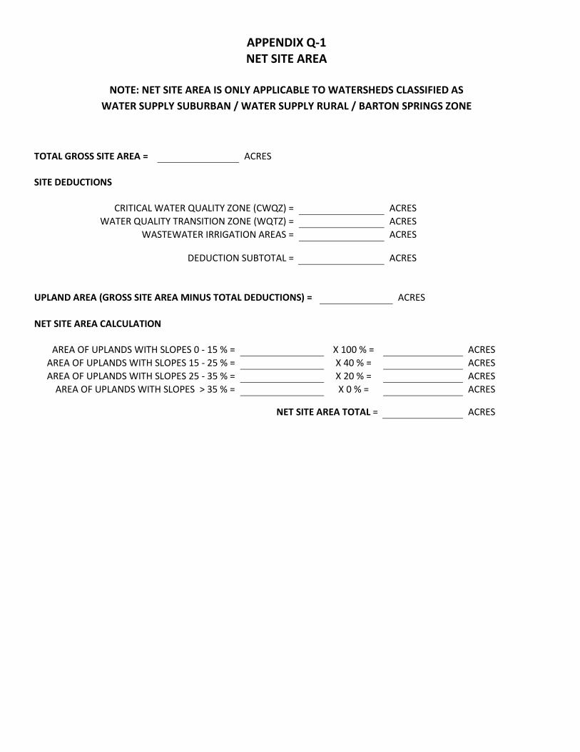
APPENDIX Q-1 NET SITE AREA
NOTE: NET SITE AREA IS ONLY APPLICABLE TO WATERSHEDS CLASSIFIED AS
WATER SUPPLY SUBURBAN / WATER SUPPLY RURAL / BARTON SPRINGS ZONE
TOTAL GROSS SITE AREA = ACRES SITE DEDUCTIONS
CRITICAL WATER QUALITY ZONE (CWQZ) = ACRES WATER QUALITY TRANSITION ZONE (WQTZ) = ACRES
WASTEWATER IRRIGATION AREAS = ACRES
DEDUCTION SUBTOTAL = ACRES UPLAND AREA (GROSS SITE AREA MINUS TOTAL DEDUCTIONS) = ACRES NET SITE AREA CALCULATION
AREA OF UPLANDS WITH SLOPES 0 - 15 % = X 100 % = ACRES AREA OF UPLANDS WITH SLOPES 15 - 25 % = X 40 % = ACRES AREA OF UPLANDS WITH SLOPES 25 - 35 % = X 20 % = ACRES
AREA OF UPLANDS WITH SLOPES > 35 % = X 0 % = ACRES
NET SITE AREA TOTAL = ACRES

APPENDIX Q-2 IMPERVIOUS COVER
WATER SUPPLY SUBURBAN / WATER SUPPLY RURAL / BARTON SPRINGS ZONE
WATER QUALITY TRANSITION ZONE
WATER QUALITY TRANSITION ZONE OUTSIDE OF 100-YEAR FLOODPLAIN (NON-FP WQTZ) = ACRES ALLOWABLE IMPERVIOUS COVER
IMPERVIOUS COVER ALLOWED AT % X NON-FP WQTZ = ACRES IMPERVIOUS COVER ALLOWED AT % X NET SITE AREA = ACRES
TOTAL IMPERVIOUS COVER ALLOWED = ACRES
ALLOWABLE IMPERVIOUS COVER BREAKDOWN BY SLOPE CATEGORY
TOTAL ACREAGE 15 - 25 % = X 10 % =
PROPOSED TOTAL IMPERVIOUS COVER
IMPERVIOUS COVER IN NON-FP WQTZ = ACRES = % IMPERVIOUS COVER IN UPLANDS ZONE = ACRES = %
TOTAL PROPOSED IMPERVIOUS COVER = ACRES
PROPOSED IMPERVIOUS COVER ON SLOPES
IMPERVIOUS COVER
BUILDING/ AND OTHER IMPERVIOUS COVER DRIVEWAYS/
ROADWAYS SLOPE
CATEGORIES ACRES ACRES % OF CATEGORY ACRES
0 - 15 % 15 - 25 % 25 - 35 % OVER 35 %
TOTAL SITE AREA

APPENDIX Q-2 IMPERVIOUS COVER
SUBURBAN WATERSHEDS
ALLOWABLE IMPERVIOUS COVER
IMPERVIOUS COVER ALLOWED AT % X GROSS SITE AREA = ACRES
ALLOWABLE IMPERVIOUS COVER BREAKDOWN BY SLOPE CATEGORY
TOTAL ACREAGE 15 - 25 % = X 10 % =
PROPOSED TOTAL IMPERVIOUS COVER
TOTAL PROPOSED IMPERVIOUS COVER = ACRES = %
PROPOSED IMPERVIOUS COVER ON SLOPES
IMPERVIOUS COVER
BUILDING/ AND OTHER IMPERVIOUS COVER DRIVEWAYS/
ROADWAYS SLOPE
CATEGORIES ACRES ACRES % OF CATEGORY ACRES
0 - 15 % 15 - 25 % 25 - 35 % OVER 35 %
TOTAL SITE AREA

APPENDIX Q-3: TRANSFERS OF DEVELOPMENT INTENSITY
Transfer of Development Intensity Chart
Lots Giving Transfer Acres Dedicated or Restricted
Total Transfer Available
Remaining Transfer Available
Lots Receiving Transfer Allowed IC without Transfer
Allowed IC with Transfer Proposed IC
Total Transfer Required
The Transfer of Development Intensity chart must be provided on preliminary plans, final plats, and site plans which propose to transfer development intensity. Place standard notes for transferring and receiving tracts below this chart. RULES FOR TRANSFERS OF DEVELOPMENT RIGHTS INTENSITY General Rules: The receiving tract and transferring tract must be platted concurrently. This may include an amended plat if city approved notes and transfer tables are included on the plats. The plats must be presented to the Planning Commission concurrently. A restrictive covenant must be filed with both the transferring and receiving tracts indicating transfer and development limitations according to the transfer notes on the plat, and subject to approval by the City. The Transfer of Development Rights chart found in Appendix Q-3 of the Environmental Criteria Manual must be provided on preliminary plans and final plats which propose to receive or to give transfer rights. Impervious cover can be transferred between subdivisions, site plans, or within a single site plan through the permanent preservation of environmentally sensitive areas (summarized below). The applicant cannot include these areas in impervious cover calculations elsewhere (e.g. not included as part of gross site area in Suburban watersheds). To qualify for transfers of development intensity, these areas can be:
1. Dedicated in fee simple to the City or another entity approved by the Director of the Watershed Protection Department. The proposed land manager responsible for maintaining the land (either the City or other approved entity) must approve acceptance of the land.
2. Restricted to the benefit of the City or another approved entity (i.e. through a conservation easement). The person responsible for inspecting and enforcing the terms of the easement (either the City or other approved entity) must approve acceptance of the easement. The easement must be approved and recorded prior to the issuance of a development permit.

The applicant shall pay all costs of restricting the land or transferring the land to the City, including the costs of:
1. An environmental site assessment without any recommendations for further clean-up, certified to the City not earlier than the 120th day before the closing date transferring land to the City;
2. A category 1(a) land title survey, certified to the City and the title company not earlier than the 120th
day before the closing date transferring land to the City; 3. A title commitment with copies of all Schedule B and C documents, and an owner's title policy; 4. A fee simple deed, or, for a restriction, a restrictive covenant approved as to form by the city attorney; 5. Taxes prorated to the closing date; 6. Recording fees; and 7. Charges or fees collected by the title company.
An applicant may transfer development intensity to a receiving tract that is within the same watershed classification as the transferring tract. This limitation does not apply if the transferring and receiving tracts are both owned by the applicant and are separated only by property that is also owned by the applicant. Impervious Cover Available for Transfer per Acre** Dedicated/Restricted Transferring Area to be Dedicated or Restricted (1 acre**)
Urban Suburban Water Supply Suburban
Water Supply Rural
Barton Springs Zone
Critical Water Quality Zone N/A 20,000 sf 15,000 sf 6,000 sf or 1 house
N/A
Water Quality Transition Zone N/A N/A 15,000 sf 6,000 sf or 1 house
N/A
100-Year Floodplain (Uplands) N/A 20,000 sf N/A N/A N/A
Other Environmentally Sensitive Area (Uplands)
N/A 20,000 sf N/A N/A N/A
**Note: If a portion of an acre is being dedicated or restricted, the impervious cover available for transfer is reduced proportionally. Notes must be provided on the final plats or site plans as described below which receive transfers indicating the total available transfers required. Subsequent notes must be provided on final plats which give transfers indicating total transfer available from this final plat and indicating which plats have received the transferred rights. The notes must also indicate the specific boundary of the transfer areas and place restrictions from future development, and must reference appropriate sections of the Land Development Code which allows the transfers to occur. Easement areas for drainage, access, utilities and other development activity cannot be included in the area proposed for transfers originating from land to be left undeveloped and undisturbed. For transfers between two subdivisions: The receiving tract and transferring tract must be platted concurrently and must transfer all development intensity at that time. This may include an amended plat if city approved notes and transfer tables are included on the plats. The plats must be presented to the Land Use Commission concurrently. The applicant

must note the development intensity transfer on the plats of the transferring and receiving tracts. In addition, a restrictive covenant approved by the City attorney must be filed that runs with the transferring tract and describes the development intensity transfer. For transfers between two site plans: The applicant must note the development intensity transfer on the transferring and receiving site plans. In addition, a restrictive covenant approved by the City attorney must be filed that runs with the transferring tract and describes the development intensity transfer. The transfer must occur before the site plans are released. For transfers within a single site plan: The applicant must file a restrictive covenant approved by the City attorney that runs with the transferring tract and describes the development intensity transfer Plat Notes Required: TRANSFER OF DEVELOPMENT RIGHTS INTENSITY PLAT NOTE (Transferring Tract). Lot _____ contains _____ acres of land to be used as transfer of development rights intensity, which equate to a total of _______ (Units or acres of impervious cover) available for transfer pursuant to Section 25-8-395, 25-8-425, 25-8-455, or 25-8-484 25-8-393, 25-8-424, or 25-8-454 of the Land Development Code (LDC), and is restricted from development pursuant to this provision. ____(Units or acres of impervious cover) is transferred to ______ lot as recorded in VOL.____ PAGE____ ____(Units or acres of impervious cover) is transferred to ______ lot as recorded in VOL.____ PAGE____ TRANSFER OF DEVELOPMENT RIGHTS INTENSITY PLAT NOTE (Receiving Tract). Lot ____ has received a total of ____ (Units or acres of impervious cover) available for transfer pursuant to Section 25-8-395, 25-8-425, 25-8-455, or 25-8-484 25-8-393, 25-8-424, or 25-8-454 of the Land Development Code and as described in the plat of record for the transferring tract. ____ (Units or acres of impervious cover) is received from ____ lot as recorded in VOL. ____ PAGE ____ ____ (Units or acres of impervious cover) is received from ____ lot as recorded in VOL. ____ PAGE ____
RESTRICTIVE COVENANT LANGUAGE.
Transferring tract: Transfer rights have been transferred from this tract pursuant to Section 25-8-395, 25-8-425, 25-8-455, or 25-8-484 of the Land Development Code and according to the notes on the Plat of Record.
Receiving tract:
Impervious cover transfer rights have been assigned to this tract pursuant to Section 25-8-395, 25-8-425, 25-8-455, or 25-8-484 of the Land Development Code and according to the notes on the Plat of Record.
A standard copy of restrictive covenants for both transferring and receiving tracts is located in Appendix U of the Environmental Criteria Manual.

Appendix Q-4: Redevelopment Exception in the Barton Springs Zone
Section 25-8-2726 of the Land Development Code (Redevelopment Exception in the Barton Springs Zone) allows for redevelopment of existing commercial properties in the Barton Springs Zone that do not comply with current watershed regulations. This section cannot be applied to existing residential uses (as defined in LDC 25-2-3 Residential Uses Described). In addition, this section cannot be applied if unpermitted development occurred on the site after January 1, 1992. The owner can elect for a property to be governed by this section when a site plan application is filed or if subdivision and site plan applications are filed concurrently. Properties may redevelop under this section provided the following conditions are met: 1. The redevelopment may not increase the existing amount of impervious cover on the site.
2. The redevelopment may not further encroach into the Critical Water Quality Zone, the Water Quality Transition Zone, or setbacks for Critical Environmental Features and wetlands.
3. The project must comply with the construction phase environmental requirements (i.e. erosion and sedimentation controls) in effect at the time of construction.
4. The redevelopment site must provide a level of water quality treatment that is equal to or greater than that which was previously provided.
5. For a commercial or multifamily redevelopment, the owner or operator must obtain an Operating Permit for all on-site water quality controls.
6. Properties with more than 40 percent net site area impervious cover must provide at least a sedimentation/filtration level of on-site water quality controls for the entire site or a combination of SOS ponds and sedimentation/filtration ponds for the entire site.
7. Properties with 40 percent or less net site area impervious cover must provide on-site water quality controls compliant with the SOS Ordinance for the entire site. No mitigation land is required.
8. The property owner must provide mitigation land if the redevelopment site has a sedimentation/filtration level of on-site water quality control. The combined gross site area impervious cover of the mitigation land and the portion of the redevelopment site treated by sedimentation/filtration ponds may not exceed 20 percent. No mitigation land is required for portions of the redevelopment site treated by SOS ponds.
9. The redevelopment may not be located within the Erosion Hazard Zone unless protective works are provided.
Project approval by a simple majority of the City Council is required if the redevelopment: 1. Includes more than 25 dwelling units;
2. Is located outside the City's zoning jurisdiction;
3. Is proposed on property with an existing industrial or civic use (as defined in LDC 25-2-5 Industrial Uses Described and 25-2-6 Civic Uses Described);
4. Is inconsistent with a neighborhood plan; or
5. Will generate more than 2,000 vehicle trips a day above the estimated traffic level based on the most recent authorized use on the property.
The mitigation requirement may be satisfied by: 1. Paying into the Barton Springs Zone Mitigation Fund (see Option 1 Worksheet);
2. Transferring mitigation land to the City of Austin or placing restrictions on mitigation land through a conservation easement (see Option 2 Worksheet); or
3. A combination of these mitigation methods (see Option 1 and Option 2 Worksheets).

If the applicant chooses to provide mitigation land in lieu of paying into the Barton Springs Zone Mitigation Fund, the person redeveloping shall pay all costs of restricting the mitigation land or transferring the mitigation land to the City, including the costs of: 1. An environmental site assessment without any recommendations for further clean-up, certified to the
City not earlier than the 120th day before the closing date transferring land to the City;
2. A category 1(a) land title survey, certified to the City and the title company not earlier than the 120th day before the closing date transferring land to the City;
3. A title commitment with copies of all Schedule B and C documents, and an owner's title policy;
4. A fee simple deed, or, for a restriction, a restrictive covenant approved as to form by the city attorney;
5. Taxes prorated to the closing date;
6. Recording fees; and
7. Charges or fees collected by the title company. The mitigation land provided by the applicant must be either greater than 100 acres in size or directly adjacent to existing protected land. The mitigation land must also have acceptable operating & maintenance (O&M) conditions, as approved by the proposed land manager. The presence of an outstanding environmental feature or attribute may allow the mitigation land to deviate slightly from the two previous criteria where desirable and appropriate, pending Director approval from the Director of the Watershed Protection Department. If the applicant is placing restrictions on the mitigation land, the conservation easement must be approved and recorded prior to the issuance of a development permit.

OPTION 1 WORKSHEET CALCULATION FOR PAYMENT INTO THE BARTON SPRINGS ZONE MITIGATION FUND
A. OWNER/AGENT INFORMATION: Name: Company: Telephone: Fax: B. PROJECT INFORMATION: Name: Location or Address: Permit Number: Case Manager: Total Gross Site Area (GSA): (ac.)
Total Net Site Area (NSA): (ac.)
Total Acres Impervious Cover: (ac.)
Percent Impervious Cover of NSA = Total Acres Impervious Cover / Total Net Site Area Percent Impervious Cover of NSA: % If the percent impervious cover is less than or equal to 40% of the net site area, then the site must use non-degradation controls and no mitigation land is required. For a list of non-degradation structural control options, please see ECM Section 1.6.9.3. C. MITIGATION CALCULATION: 1. OVERALL MITIGATION Overall Mitigation Required (ac.) = (Total Acres Impervious Cover / 0.20) - Acres Gross Site Area
Overall Mitigation Required: (ac.) If the entire site is treated with sedimentation/sand filtration or an equivalent level of water quality control, skip to section 3. Final Mitigation Required is equal to Overall Mitigation Required. 2. NON-DEGRADATION (ND) REDUCTION Total Site Area Treated with ND Controls (including Treatment Area): (ac.)
Total Acres Impervious Cover Treated with ND Controls: (ac.)
Non-Degradation Reduction (ac.) = (Acres of ND Impervious Cover / 0.20) - Acres of ND Site Area
Non-Degradation Reduction: (ac.) 3. FINAL MITIGATION Final Mitigation Required (ac.) = Overall Mitigation - Non-Degradation Reduction
Final Mitigation Required: (ac.)

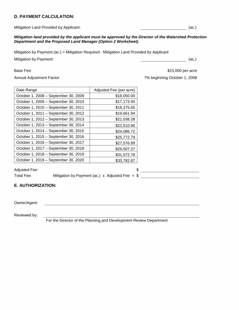
D. PAYMENT CALCULATION: Mitigation Land Provided by Applicant: (ac.) Mitigation land provided by the applicant must be approved by the Director of the Watershed Protection and Development Review Department and the Proposed Land Manager (Option 2 Worksheet). Mitigation by Payment (ac.) = Final Mitigation Required - Mitigation Land Provided by Applicant
Mitigation by Payment: (ac.) Base Fee: $15,000 per acre
Annual Adjustment Factor: 7% beginning October 1, 2008
Date Range Adjusted Fee (per acre) October 1, 2008 – September 30, 2009 $16,050.00 October 1, 2009 – September 30, 2010 $17,173.50 October 1, 2010 – September 30, 2011 $18,375.65 October 1, 2011 – September 30, 2012 $19,661.94 October 1, 2012 – September 30, 2013 $21,038.28 October 1, 2013 – September 30, 2014 $22,510.96 October 1, 2014 – September 30, 2015 $24,086.72 October 1, 2015 – September 30, 2016 $25,772.79 October 1, 2016 – September 30, 2017 $27,576.89 October 1, 2017 – September 30, 2018 $29,507.27 October 1, 2018 – September 30, 2019 $31,572.78 October 1, 2019 – September 30, 2020 $33,782.87
Adjusted Fee: $ Total Fee: Mitigation by Payment (ac.) x Adjusted Fee = $ E. AUTHORIZATION:
Owner/Agent:
Reviewed by:
For the Director of the Watershed Protection Planning and Development Review Department

INSTRUCTIONS FOR COMPLETING OPTION 1 WORKSHEET CALCULATION FOR PAYMENT INTO THE BARTON SPRINGS ZONE MITIGATION FUND
PART A. OWNER/AGENT INFORMATION Provide the name of the owner or agent, the name of the company, and the telephone and fax number. PART B. PROJECT INFORMATION Provide the name of the project, the location or address, the site development or site plan number, and the name of the case manager in the Watershed Protection Planning and Development Review Department. Provide the Gross Site Area in acres of the entire site. Provide the Net Site Area in acres of the entire site. See Land Development Code Section 25-8-62 (Net Site Area). Provide the total proposed impervious cover in acres. Total proposed impervious cover should also include existing impervious cover on the site that will remain after redevelopment. Impervious cover shall be measured to the nearest 0.01 acre. Calculate the percent of impervious cover for the Net Site Area by dividing the acres of impervious cover (Total Acres Impervious Cover) by the acres of net site area (Total Net Site Area). If the percent impervious cover is less than or equal to 40% of the Net Site Area, then the site must use non-degradation controls and no mitigation land is required. PART C. MITIGATION CALCULATION 1. OVERALL MITIGATION Calculate the acres of Overall Mitigation Required by dividing the acres of impervious cover (Total Acres Impervious Cover) by 0.20 and subtracting the acres of gross site area (Total Gross Site Area). If the entire site is treated with sedimentation/sand filtration or an equivalent level of water quality control, skip to Section 3 – Final Mitigation. Final Mitigation Required is equal to Overall Mitigation Required. 2. NON-DEGRADATION (ND) REDUCTION If a portion of the site is treated with non-degradation controls, mitigation land is not required for that portion of the site. The Non-Degradation Reduction will be deducted from the Overall Mitigation Required to determine the Final Mitigation Required. Non-degradation controls (or "SOS Ponds") are water quality controls that comply with all requirements of Section 25-8-213 (Water Quality Control Standards) and the pollutant removal requirements of Section 25-8-514(A) (Pollutant Prevention Required). The design of these controls is further outlined in ECM 1.6.9.3. Calculate the total site area treated with non-degradation controls. This includes the site area treated by the control as well as the pervious treatment areas used for irrigation or infiltration. Calculate the total impervious cover in acres that will be treated with non-degradation controls. Calculate the Non-Degradation Reduction by dividing the total acres of impervious cover treated with non-degradation controls (Acres of ND Impervious Cover) by 0.20 and subtracting the total site area treated with non-degradation controls (Acres of ND Site Area).

3. FINAL MITIGATION Calculate the Final Mitigation Required by subtracting the Non-Degradation Reduction (if applicable) from the Overall Mitigation Required. If no portion of the site is being treated with non-degradation controls, the Final Mitigation Required is the same as the Overall Mitigation Required. PART D. PAYMENT CALCULATION Provide, if applicable, the amount of mitigation land in acres provided by the applicant. The mitigation land must be approved by the Director of the Watershed Protection and Development Review Department and the Proposed Land Manager (Option 2 Worksheet). Calculate the amount of mitigation land in acres that will be satisfied through payment into the Barton Springs Zone Mitigation Fund (Mitigation by Payment) by subtracting the mitigation land provided by the applicant from the Final Mitigation Required. If all mitigation requirements will be satisfied through payment into the fund, Mitigation by Payment is equal to Final Mitigation Required. The base fee ($15,000/acre) and annual adjustment factor (7% beginning October 1, 2008) were established by Ordinance No. 20071108-121. Both the base fee and the annual increase shall be reviewed and adjusted by Council every three years based on current market data. Use the provided table and the date of project submittal to determine the Adjusted Fee. Calculate the Total Fee by multiplying the acres of Mitigation by Payment by the Adjusted Fee. PART E. AUTHORIZATION The owner or agent for the project must sign and date the form. Upon review and approval of the payment, the Director of the Watershed Protection Planning and Development Review Department or their designee will sign and date the form indicating approval of the proposed payment.

OPTION 2 WORKSHEET EVALUATION OF MITIGATION LAND IN LIEU OF PAYMENT
INTO BARTON SPRINGS ZONE MITIGATION FUND
A. OWNER/AGENT INFORMATION: Name: Company: Telephone: Fax: B. PROJECT INFORMATION: Name: Location or Address: Permit Number: Case Manager: C. PROPOSED MITIGATION LAND INFORMATION: Titleholder: Location or Address: Tax Parcel ID: Total Gross Site Area (GSA) to be Transferred: (ac.)
Total Gross Site Area (GSA) to be Restricted: (ac.)
Total Proposed Mitigation Land (ac.) = Total GSA to be Transferred + Total GSA to be Restricted
Total Proposed Mitigation Land: (ac.) D. MITIGATION CRITERIA:
1. Must be greater than 100 acres (gross site area) unless directly adjacent to existing protected land. The protected land does not have to be owned by the City of Austin.
Greater than 100 Acres (Gross Site Area) Yes No
Directly Adjacent to Existing Protected Land Yes No
If Directly Adjacent to Existing Protected Land:
Name:
Owner:
Location or Address:
2. Must have acceptable operations and maintenance (O&M) conditions, as approved by the receiving department. The land may also be managed by a not-for-profit land trust.
Proposed Land Manager:
3. The presence of an outstanding environmental feature or attribute may allow the mitigation land to
deviate slightly from the two previous criteria where desirable and appropriate, pending Director approval by the director of the Watershed Protection Department.
Description of Environmental Feature or Attribute:
E. AUTHORIZATION:
Owner/Agent:
Reviewed by:
For the Director of the Watershed Protection and Development Review Department
Reviewed by: For the Proposed Land Manager

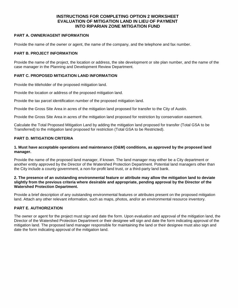
INSTRUCTIONS FOR COMPLETING OPTION 2 WORKSHEET EVALUATION OF MITIGATION LAND IN LIEU OF PAYMENT
INTO BARTON SPRINGS ZONE MITIGATION FUND PART A. OWNER/AGENT INFORMATION Provide the name of the owner or agent, the name of the company, and the telephone and fax number. PART B. PROJECT INFORMATION Provide the name of the project, the location or address, the site development or site plan number, and the name of the case manager in the Watershed Protection Planning and Development Review Department. PART C. PROPOSED MITIGATION LAND INFORMATION Redevelopment of property in the Barton Springs Zone under Section 25-8-2726 requires the purchase or restriction of mitigation land if the site has a sedimentation/filtration pond or an equivalent level of treatment. The mitigation requirement can be satisfied by:
- Paying into the Barton Springs Zone Mitigation Fund (Option 1 Worksheet); - Transferring mitigation land to the City; - Placing restrictions on mitigation land through a conservation easement; or - A combination of these mitigation methods.
The combined gross site area impervious cover of the mitigation land and the portion of the redevelopment site treated by sedimentation/filtration ponds may not exceed 20 percent. The mitigation land must be within a watershed that contributes recharge to Barton Springs, either inside or outside the City’s jurisdiction. In lieu of paying into the Barton Springs Zone Mitigation Fund, Section 25-8-27(I)26(H) of the Land Development Code requires the Director of the Watershed Protection and Development Review Department to evaluate and accept or deny the proposed mitigation land. Provide the titleholder of the proposed mitigation land. Provide the location or address of the proposed mitigation land. Provide the tax parcel identification number of the proposed mitigation land. Provide the Gross Site Area in acres of the mitigation land proposed for transfer to the City of Austin. Provide the Gross Site Area in acres of the mitigation land proposed for restriction by conservation easement. Calculate the Total Proposed Mitigation Land by adding the mitigation land proposed for transfer (Total GSA to be Transferred) to the mitigation land proposed for restriction (Total GSA to be Restricted). PART D. MITIGATION CRITERIA 1. Must be greater than 100 acres (gross site area) unless directly adjacent to existing protected land. The protected land does not have to be owned by the City of Austin. Indicate whether the gross site area of the proposed mitigation land is greater than 100 acres. Indicate whether the proposed mitigation land is directly adjacent to existing protected land. If the proposed mitigation land is directly adjacent to existing protected land, provide the name of the protected land, the owner of the land, and the location or address. 2. Must have acceptable operations and maintenance (O&M) conditions, as approved by the receiving department. The land may also be managed by a not-for-profit land trust. Provide the name of the proposed land manager, if known. If the land is fee simple and directly adjacent to City of Austin parkland, the assumed land manager is the Parks and Recreation Department (PARD). Any land being transferred to PARD must be for passive use only and cannot be used to satisfy parkland dedication requirements. If the land is fee simple and not directly adjacent to City of Austin parkland,

the assumed land manager is the Wildland Conservation Division of the Austin Water Utility. If the land is being placed under restriction through a conservation easement, the assumed land manager is the Wildland Conservation Division or a not-for-profit land trust. The conservation easement must be approved and recorded prior to the issuance of a development permit. 3. The presence of an outstanding environmental feature or attribute may allow the mitigation land to deviate slightly from the two previous criteria where desirable and appropriate, pending Director approval by the Director of the Watershed Protection Department. Provide a brief description of any outstanding environmental features or attributes present on the proposed mitigation land. Attach any other relevant information, such as maps, photos, and/or an environmental assessment resource inventory. PART E. AUTHORIZATION The owner or agent for the project must sign and date the form. Upon evaluation and approval of the mitigation land, the Director of the Watershed Protection and Development Review Department or their designee will sign and date the form indicating approval of the mitigation land. The proposed land manager responsible for maintaining the land or their designee must also sign and date the form indicating approval of the mitigation land.

APPENDIX Q-5: VERTICAL MIXED USE ALLOWABLE IMPERVIOUS COVER
Goals: (1) Determine a method for quickly and accurately calculating mixed use development impervious cover limits in suburban, full purpose watersheds; (2) Encourage mixed use development; (3) Discourage vehicle trips; and (4) Discourage urban sprawl. Impervious Cover Calculation: Provided that the requirements below are satisfied, the impervious cover limit for a vertical mixed use development will be calculated on a simple ratio basis. For example, in a watershed where impervious cover for a multi-family use and impervious cover for a commercial use may not exceed 60% and 80% respectively, if 25% of the building ground floor area is dedicated to commercial use and 75% of the building ground floor area is dedicated to multi-family use, then the impervious cover limit will be calculated by multiplying 25% of the net gross site area by 80% and multiplying 75% of the netgross site area by 60% and adding them together. This reflects the different impervious cover limits applicable to residentialcommercial and multi-family uses under City Code Chapter 25-8 (Environment). Requirements: (1) The proposed development must be located in the suburban, full purpose watershed; (2) The proposed development must consist of commercial and multi-family uses on a single lot; and (3) To qualify for mixed use impervious cover limit increases, payment into the tree fund in lieu of tree mitigation will not be permitted.

Appendix Q-6: Redevelopment Exception in the Water Supply Rural and Water Supply Suburban Watersheds
Section 25-8-27 of the Land Development Code (Redevelopment Exception in the Water Supply Rural and Water Supply Suburban Watersheds) allows for redevelopment of existing properties in the Water Supply Rural and Water Supply Suburban watersheds that do not comply with current watershed regulations. This section cannot be applied to existing residential development with two dwelling units or less per lot. In addition, this section cannot be applied if unpermitted development occurred on the site after January 1, 1992. The owner can elect for a property to be governed by this section when a site plan application is filed or if subdivision and site plan applications are filed concurrently. Properties may redevelop under this section provided the following conditions are met: 1. The redevelopment may not increase the existing amount of impervious cover on the site.
2. The redevelopment may not further encroach into the Critical Water Quality Zone, the Water Quality Transition Zone, or setbacks for Critical Environmental Features and wetlands.
3. The project must comply with the construction phase environmental requirements (i.e. erosion and sedimentation controls) in effect at the time of construction.
4. The redevelopment site must provide a level of water quality treatment that is equal to or greater than that which was previously provided. At a minimum, the site must provide sedimentation/filtration ponds for the redeveloped area or an equivalent area on the site.
5. The property owner must provide mitigation land. The combined gross site area impervious cover of the mitigation land and the portion of the redevelopment site treated by sedimentation/filtration ponds may not exceed 20 percent if in a water supply rural watershed or 40 percent if in a water supply suburban watershed.
6. The redevelopment may not be located within the Erosion Hazard Zone unless protective works are provided.
Project approval by a simple majority of the City Council is required if the redevelopment: 1. Includes more than 25 additional dwelling units;
2. Is located outside the City's zoning jurisdiction;
3. Is proposed on property with an existing industrial use (as defined in LDC 25-2-5 Industrial Uses Described);
4. Is inconsistent with a neighborhood plan; or
5. Will generate more than 2,000 vehicle trips a day above the estimated traffic level based on the most recent authorized use on the property.
The mitigation requirement may be satisfied by: 1. Paying into the Water Supply Mitigation Fund (see Option 1 Worksheet);
2. Transferring mitigation land to the City of Austin or placing restrictions on mitigation land through a conservation easement (see Option 2 Worksheet); or
3. A combination of these mitigation methods (see Option 1 and Option 2 Worksheets). If the applicant chooses to provide mitigation land in lieu of paying into the Water Supply Mitigation Fund, the person redeveloping shall pay all costs of restricting the mitigation land or transferring the mitigation land to the City, including the costs of: 1. An environmental site assessment without any recommendations for further clean-up, certified to the
City not earlier than the 120th day before the closing date transferring land to the City;

2. A category 1(a) land title survey, certified to the City and the title company not earlier than the 120th day before the closing date transferring land to the City;
3. A title commitment with copies of all Schedule B and C documents, and an owner's title policy;
4. A fee simple deed, or, for a restriction, a restrictive covenant approved as to form by the city attorney;
5. Taxes prorated to the closing date;
6. Recording fees; and
7. Charges or fees collected by the title company. The mitigation land provided by the applicant must be either greater than 100 acres in size or directly adjacent to existing protected land. The mitigation land must also have acceptable operating & maintenance (O&M) conditions, as approved by the proposed land manager. The presence of an outstanding environmental feature or attribute may allow the mitigation land to deviate slightly from the two previous criteria where desirable and appropriate, pending approval from the Director of the Watershed Protection Department. If the applicant is placing restrictions on the mitigation land, the conservation easement must be approved and recorded prior to the issuance of a development permit.

OPTION 1 WORKSHEET CALCULATION FOR PAYMENT INTO THE WATER SUPPLY MITIGATION FUND
A. OWNER/AGENT INFORMATION: Name: Company: Telephone: Fax: B. PROJECT INFORMATION: Name: Location or Address: Permit Number: Case Manager: Total Gross Site Area (GSA): (ac.)
Total Net Site Area (NSA): (ac.)
Total Acres Impervious Cover: (ac.)
Percent Impervious Cover of NSA = Total Acres Impervious Cover / Total Net Site Area Percent Impervious Cover of NSA: % C. MITIGATION CALCULATION: 1. WATER SUPPLY RURAL (WSR) WSR Mitigation Required (ac.) = (Total Acres Impervious Cover / 0.20) - Acres Gross Site Area
WSR Mitigation Required: (ac.) 2. WATER SUPPLY SUBURBAN (WSS) WSS Mitigation Required (ac.) = (Total Acres Impervious Cover / 0.40) - Acres Gross Site Area
WSS Mitigation Required: (ac.)
D. PAYMENT CALCULATION: Mitigation Land Provided by Applicant: (ac.) Mitigation land provided by the applicant must be approved by the Director of the Watershed Protection Department and the Proposed Land Manager (Option 2 Worksheet). Mitigation by Payment (ac.) = Mitigation Required - Mitigation Land Provided by Applicant
Mitigation by Payment: (ac.) Base Fee: $15,000 per acre
Annual Adjustment Factor: 7% beginning October 1, 2008
Date Range Adjusted Fee (per acre) October 1, 2008 – September 30, 2009 $16,050.00 October 1, 2009 – September 30, 2010 $17,173.50 October 1, 2010 – September 30, 2011 $18,375.65 October 1, 2011 – September 30, 2012 $19,661.94 October 1, 2012 – September 30, 2013 $21,038.28 October 1, 2013 – September 30, 2014 $22,510.96 October 1, 2014 – September 30, 2015 $24,086.72 October 1, 2015 – September 30, 2016 $25,772.79 October 1, 2016 – September 30, 2017 $27,576.89 October 1, 2017 – September 30, 2018 $29,507.27 October 1, 2018 – September 30, 2019 $31,572.78 October 1, 2019 – September 30, 2020 $33,782.87
Adjusted Fee: $ Total Fee: Mitigation by Payment (ac.) x Adjusted Fee = $ E. AUTHORIZATION:
Owner/Agent:
Reviewed by:
For the Director of the Planning and Development Review Department

INSTRUCTIONS FOR COMPLETING OPTION 1 WORKSHEET CALCULATION FOR PAYMENT INTO THE WATER SUPPLY MITIGATION FUND
PART A. OWNER/AGENT INFORMATION Provide the name of the owner or agent, the name of the company, and the telephone and fax number. PART B. PROJECT INFORMATION Provide the name of the project, the location or address, the site development or site plan number, and the name of the case manager in the Planning and Development Review Department. Provide the Gross Site Area in acres of the entire site. Provide the Net Site Area in acres of the entire site. See Land Development Code Section 25-8-62 (Net Site Area). Provide the total proposed impervious cover in acres. Total proposed impervious cover should also include existing impervious cover on the site that will remain after redevelopment. Impervious cover shall be measured to the nearest 0.01 acre. Calculate the percent of impervious cover for the Net Site Area by dividing the acres of impervious cover (Total Acres Impervious Cover) by the acres of net site area (Total Net Site Area). PART C. MITIGATION CALCULATION 1. WATER SUPPLY RURAL (WSR) MITIGATION If the site is located within a water supply rural watershed, calculate the acres of WSR Mitigation Required by dividing the acres of impervious cover (Total Acres Impervious Cover) by 0.20 and subtracting the acres of gross site area (Total Gross Site Area). 2. WATER SUPPLY SUBURBAN (WSS) MITIGATION If the site is located within a water supply suburban watershed, calculate the acres of WSS Mitigation Required by dividing the acres of impervious cover (Total Acres Impervious Cover) by 0.40 and subtracting the acres of gross site area (Total Gross Site Area). PART D. PAYMENT CALCULATION Provide, if applicable, the amount of mitigation land in acres provided by the applicant. The mitigation land must be approved by the Director of the Watershed Protection Department and the Proposed Land Manager (Option 2 Worksheet). Calculate the amount of mitigation land in acres that will be satisfied through payment into the Water Supply Mitigation Fund (Mitigation by Payment) by subtracting the mitigation land provided by the applicant from the Mitigation Required. If all mitigation requirements will be satisfied through payment into the fund, Mitigation by Payment is equal to Mitigation Required. The base fee ($15,000/acre) and annual adjustment factor (7% beginning October 1, 2008) were established by Ordinance No. 20071108-121. Both the base fee and the annual increase shall be reviewed and adjusted by Council every three years based on current market data. Use the provided table and the date of project submittal to determine the Adjusted Fee. Calculate the Total Fee by multiplying the acres of Mitigation by Payment by the Adjusted Fee. PART E. AUTHORIZATION The owner or agent for the project must sign and date the form. Upon review and approval of the payment, the Director of the Planning and Development Review Department or their designee will sign and date the form indicating approval of the proposed payment.

OPTION 2 WORKSHEET EVALUATION OF MITIGATION LAND IN LIEU OF PAYMENT
INTO WATER SUPPLY MITIGATION FUND
A. OWNER/AGENT INFORMATION: Name: Company: Telephone: Fax: B. PROJECT INFORMATION: Name: Location or Address: Permit Number: Case Manager: C. PROPOSED MITIGATION LAND INFORMATION: Titleholder: Location or Address: Tax Parcel ID: Total Gross Site Area (GSA) to be Transferred: (ac.)
Total Gross Site Area (GSA) to be Restricted: (ac.)
Total Proposed Mitigation Land (ac.) = Total GSA to be Transferred + Total GSA to be Restricted
Total Proposed Mitigation Land: (ac.) D. MITIGATION CRITERIA:
1. Must be greater than 100 acres (gross site area) unless directly adjacent to existing protected land. The protected land does not have to be owned by the City of Austin.
Greater than 100 Acres (Gross Site Area) Yes No
Directly Adjacent to Existing Protected Land Yes No
If Directly Adjacent to Existing Protected Land:
Name:
Owner:
Location or Address:

2. Must have acceptable operations and maintenance (O&M) conditions, as approved by the receiving department. The land may also be managed by a not-for-profit land trust.
Proposed Land Manager:
3. The presence of an outstanding environmental feature or attribute may allow the mitigation land to
deviate slightly from the two previous criteria where desirable and appropriate, pending approval by the director of the Watershed Protection Department.
Description of Environmental Feature or Attribute:
E. AUTHORIZATION:
Owner/Agent:
Reviewed by:
For the Director of the Watershed Protection Department
Reviewed by: For the Proposed Land Manager

INSTRUCTIONS FOR COMPLETING OPTION 2 WORKSHEET EVALUATION OF MITIGATION LAND IN LIEU OF PAYMENT
INTO WATER SUPPLY MITIGATION FUND PART A. OWNER/AGENT INFORMATION Provide the name of the owner or agent, the name of the company, and the telephone and fax number. PART B. PROJECT INFORMATION Provide the name of the project, the location or address, the site development or site plan number, and the name of the case manager in the Planning and Development Review Department. PART C. PROPOSED MITIGATION LAND INFORMATION Redevelopment of property in the Water Supply Rural and Water Supply Suburban watersheds under Section 25-8-27 requires the purchase or restriction of mitigation land if the site has a sedimentation/filtration pond or an equivalent level of treatment. The mitigation requirement can be satisfied by:
- Paying into the Water Supply Mitigation Fund (Option 1 Worksheet); - Transferring mitigation land to the City; - Placing restrictions on mitigation land through a conservation easement; or - A combination of these mitigation methods.
The combined gross site area impervious cover of the mitigation land and the portion of the redevelopment site treated by sedimentation/filtration ponds may not exceed 20 percent if in a water supply rural watershed or 40 percent if in a water supply suburban watershed. The mitigation land must be within a water supply rural or water supply suburban watershed, either inside or outside the City’s jurisdiction. In lieu of paying into the Water Supply Mitigation Fund, Section 25-8-27(G) of the Land Development Code requires the Director of the Watershed Protection Department to evaluate and accept or deny the proposed mitigation land. Provide the titleholder of the proposed mitigation land. Provide the location or address of the proposed mitigation land. Provide the tax parcel identification number of the proposed mitigation land. Provide the Gross Site Area in acres of the mitigation land proposed for transfer to the City of Austin. Provide the Gross Site Area in acres of the mitigation land proposed for restriction by conservation easement. Calculate the Total Proposed Mitigation Land by adding the mitigation land proposed for transfer (Total GSA to be Transferred) to the mitigation land proposed for restriction (Total GSA to be Restricted). PART D. MITIGATION CRITERIA 1. Must be greater than 100 acres (gross site area) unless directly adjacent to existing protected land. The protected land does not have to be owned by the City of Austin. Indicate whether the gross site area of the proposed mitigation land is greater than 100 acres. Indicate whether the proposed mitigation land is directly adjacent to existing protected land. If the proposed mitigation land is directly adjacent to existing protected land, provide the name of the protected land, the owner of the land, and the location or address. 2. Must have acceptable operations and maintenance (O&M) conditions, as approved by the receiving department. The land may also be managed by a not-for-profit land trust. Provide the name of the proposed land manager, if known. If the land is fee simple and directly adjacent to City of Austin parkland, the assumed land manager is the Parks and Recreation Department (PARD). Any land being transferred to PARD must be for passive use only and cannot be used to satisfy parkland dedication requirements. If the land is fee simple and not directly adjacent to City of Austin parkland,

the assumed land manager is the Wildland Conservation Division of the Austin Water Utility. If the land is being placed under restriction through a conservation easement, the assumed land manager is the Wildland Conservation Division or a not-for-profit land trust. The conservation easement must be approved and recorded prior to the issuance of a development permit. 3. The presence of an outstanding environmental feature or attribute may allow the mitigation land to deviate slightly from the two previous criteria where desirable and appropriate, pending approval by the Director of the Watershed Protection Department. Provide a brief description of any outstanding environmental features or attributes present on the proposed mitigation land. Attach any other relevant information, such as maps, photos, and/or an environmental resource inventory. PART E. AUTHORIZATION The owner or agent for the project must sign and date the form. Upon evaluation and approval of the mitigation land, the Director of the Watershed Protection Department or their designee will sign and date the form indicating approval of the mitigation land. The proposed land manager responsible for maintaining the land or their designee must also sign and date the form indicating approval of the mitigation land.

Appendix Q-7: Riparian Zone Mitigation
Section 25-8-364 of the Land Development Code (Floodplain Modification) allows for mitigation where restoration of floodplain health is infeasible, in accordance with Section 1.7 of this manual. The mitigation requirement may be satisfied by:
(1) Paying into the Water Supply Mitigation Fund (see Option 1 Worksheet);
(2) Transferring mitigation land to the City of Austin or placing restrictions on mitigation land through a conservation easement (see Option 2 Worksheet); or
(3) A combination of these mitigation methods (see Option 1 and Option 2 Worksheets). Section 25-8-261 of the Land Development Code (Critical Water Quality Zone Development) allows for payment into the Riparian Zone Mitigation Fund as mitigation for a utility line in urban and suburban watersheds located parallel to and within the Critical Water Quality Zone (CWQZ) if on-site restoration is infeasible, in accordance with Section 1.5 of this manual. If land is dedicated or restricted, it must be approved by the City and the applicant must file in the deed records a restrictive covenant, approved by the city attorney, that runs with the transferring tract and describes the restrictions on development and vegetation management. In addition, the applicant shall pay all costs of restricting the mitigation land or transferring the mitigation land to the City, including the costs of:
(a) an environmental site assessment without any recommendations for further clean-up, certified to the City not earlier than the 120th day before the closing date transferring land to the City;
(b) a category 1(a) land title survey, certified to the City and the title company not earlier than the 120th day before the closing date transferring land to the City;
(c) a title commitment with copies of all Schedule B and C documents, and an owner's title policy;
(d) a fee simple deed, or, for a restriction, a restrictive covenant approved as to form by the city attorney;
(e) taxes prorated to the closing date;
(f) recording fees; and charges or fees collected by the title company.
The mitigation land must also have acceptable operating & maintenance (O&M) conditions, as approved by the proposed land manager. The presence of an outstanding environmental feature or attribute may allow the mitigation land to deviate slightly from the previous criteria where desirable and appropriate, pending approval from the Director of the Watershed Protection Department. If the applicant is placing restrictions on the mitigation land, the conservation easement must be approved and recorded prior to the issuance of a development permit.

OPTION 1 WORKSHEET CALCULATION FOR PAYMENT INTO THE RIPARIAN ZONE MITIGATION FUND
A. OWNER/AGENT INFORMATION: Name: Company: Telephone: Fax: B. PROJECT INFORMATION: Name: Location or Address: Permit Number: Case Manager: C. MITIGATION REQUIRED Area Modified within the 100-Year Floodplain: (ac.)
Area Disturbed by a Parallel Utility within the CWQZ: (ac.) Ratio Applied (circle): 1:1 2:1 3:1 4:1 6:1 8:1 The ratio for an area modified within the 100-Year Floodplain is determined by ECM 1.7.6. The ratio is 1:1 for a parallel utility within the CWQZ. Multiply the acres modified or disturbed by the ratio to determine the mitigation required. Mitigation Required: (ac.) D. PAYMENT CALCULATION: Mitigation Land Provided by Applicant: (ac.) Mitigation land provided by the applicant must be approved by the Director of the Watershed Protection Department and the Proposed Land Manager (Option 2 Worksheet). A project disturbing the CWQZ with a parallel utility does not have the option to provide mitigation land. Mitigation by Payment (ac.) = Mitigation Required - Mitigation Land Provided by Applicant
Mitigation by Payment: (ac.) Base Fee: $15,000 per acre
Annual Adjustment Factor: 7% beginning October 1, 2008
Date Range Adjusted Fee (per acre) October 1, 2008 – September 30, 2009 $16,050.00 October 1, 2009 – September 30, 2010 $17,173.50 October 1, 2010 – September 30, 2011 $18,375.65 October 1, 2011 – September 30, 2012 $19,661.94 October 1, 2012 – September 30, 2013 $21,038.28 October 1, 2013 – September 30, 2014 $22,510.96

October 1, 2014 – September 30, 2015 $24,086.72 October 1, 2015 – September 30, 2016 $25,772.79 October 1, 2016 – September 30, 2017 $27,576.89 October 1, 2017 – September 30, 2018 $29,507.27 October 1, 2018 – September 30, 2019 $31,572.78 October 1, 2019 – September 30, 2020 $33,782.87
Adjusted Fee: $ Total Fee: Mitigation by Payment (ac.) x Adjusted Fee = $ E. AUTHORIZATION:
Owner/Agent:
Reviewed by:
For the Director of the Planning and Development Review Department

INSTRUCTIONS FOR COMPLETING OPTION 1 WORKSHEET CALCULATION FOR PAYMENT INTO THE RIPARIAN ZONE MITIGATION FUND
PART A. OWNER/AGENT INFORMATION Provide the name of the owner or agent, the name of the company, and the telephone and fax number. PART B. PROJECT INFORMATION Provide the name of the project, the location or address, the site development or site plan number, and the name of the case manager in the Planning and Development Review Department. PART C. MITIGATION CALCULATION Provide, if applicable, the area in acres of 100-year floodplain proposed to be modified. Provide, if applicable, the area in acres of Critical Water Quality Zone (CWQZ) proposed to be disturbed by a parallel utility line. Determine the required mitigation ratio for the area proposed to be modified or disturbed. For an area proposed to be modified within the 100-year floodplain, use the table below. (See ECM 1.7.0 for more information on floodplain modification.) For an area in the CWQZ proposed to be disturbed by a parallel utility line, the ratio is 1:1. (See ECM 1.5.0 for more information on parallel utilities. Parallel utility lines are only allowed within the CWQZ in urban and suburban watersheds.) Condition of the Area Proposed for Floodplain Modification (as determined by Functional Assessment)
Location of Proposed Modification Outside Critical Water Quality Zone
Critical Water Quality Zone
Good or Excellent 4:1* 8:1* Fair 3:1 6:1* Poor 2:1 4:1* Calculate the mitigation required by multiplying the acres modified or disturbed by the applicable ratio. PART D. PAYMENT CALCULATION Provide, if applicable, the amount of mitigation land in acres provided by the applicant. The mitigation land must be approved by the Director of the Watershed Protection Department and the Proposed Land Manager (Option 2 Worksheet). A project disturbing the CWQZ with a parallel utility does not have the option to provide mitigation land. Calculate the amount of mitigation land in acres that will be satisfied through payment into the Riparian Zone Mitigation Fund (Mitigation by Payment) by subtracting the mitigation land provided by the applicant from the Mitigation Required. If all mitigation requirements will be satisfied through payment into the fund, Mitigation by Payment is equal to Mitigation Required. The base fee ($15,000/acre) and annual adjustment factor (7% beginning October 1, 2008) were established by Ordinance No. 20071108-121. Both the base fee and the annual increase shall be reviewed and adjusted by Council every three years based on current market data. Use the provided table and the date of project submittal to determine the Adjusted Fee. Calculate the Total Fee by multiplying the acres of Mitigation by Payment by the Adjusted Fee. PART E. AUTHORIZATION The owner or agent for the project must sign and date the form. Upon review and approval of the payment, the Director of the Planning and Development Review Department or their designee will sign and date the form indicating approval of the proposed payment.

OPTION 2 WORKSHEET EVALUATION OF MITIGATION LAND IN LIEU OF PAYMENT
INTO RIPARIAN ZONE MITIGATION FUND
A. OWNER/AGENT INFORMATION: Name: Company: Telephone: Fax: B. PROJECT INFORMATION: Name: Location or Address: Permit Number: Case Manager: C. PROPOSED MITIGATION LAND INFORMATION: Titleholder: Location or Address: Tax Parcel ID: Total Gross Site Area (GSA) to be Transferred: (ac.)
Total Gross Site Area (GSA) to be Restricted: (ac.)
Total Proposed Mitigation Land (ac.) = Total GSA to be Transferred + Total GSA to be Restricted
Total Proposed Mitigation Land: (ac.) D. MITIGATION CRITERIA:
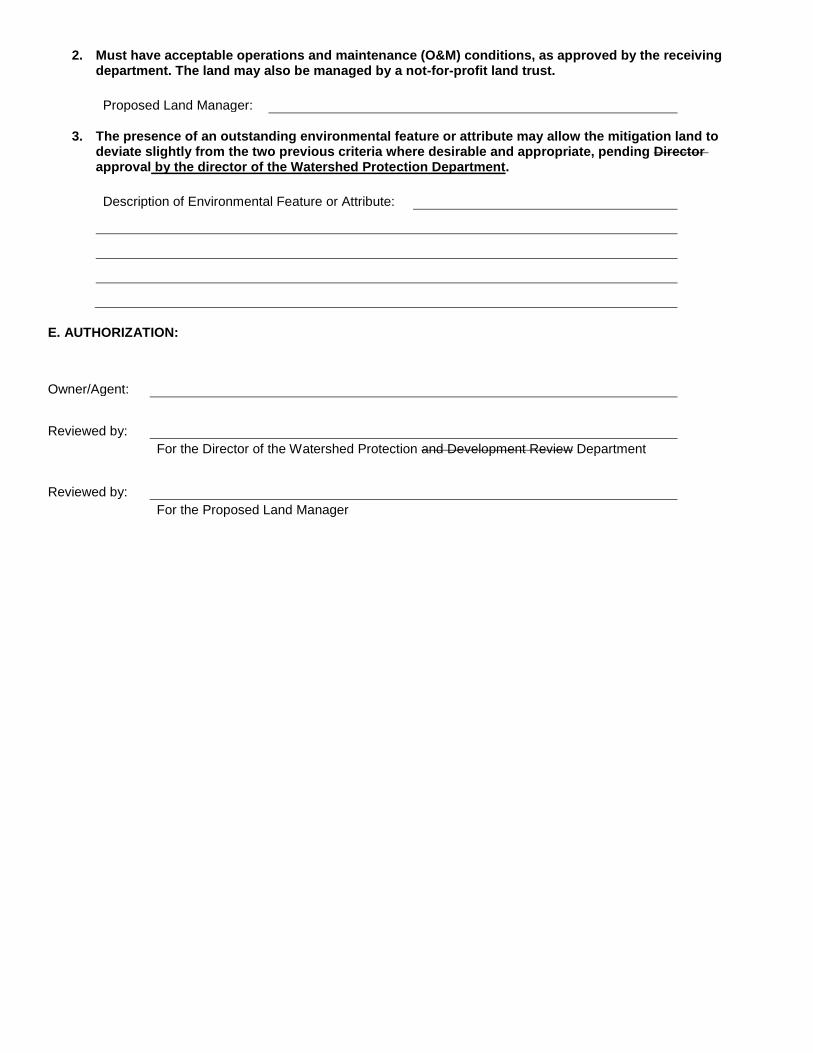
1. Must have acceptable operations and maintenance (O&M) conditions, as approved by the proposed land manager.
Proposed Land Manager:
2. The presence of an outstanding environmental feature or attribute may allow the mitigation land to
deviate slightly from the previous criteria where desirable and appropriate, pending approval by the director of the Watershed Protection Department.
Description of Environmental Feature or Attribute:

E. AUTHORIZATION:
Owner/Agent:
Reviewed by:
For the Director of the Watershed Protection Department
Reviewed by: For the Proposed Land Manager
INSTRUCTIONS FOR COMPLETING OPTION 2 WORKSHEET EVALUATION OF MITIGATION LAND IN LIEU OF PAYMENT
INTO RIPARIAN ZONE MITIGATION FUND PART A. OWNER/AGENT INFORMATION Provide the name of the owner or agent, the name of the company, and the telephone and fax number. PART B. PROJECT INFORMATION Provide the name of the project, the location or address, the site development or site plan number, and the name of the case manager in the Planning and Development Review Department. PART C. PROPOSED MITIGATION LAND INFORMATION Provide the titleholder of the proposed mitigation land. Provide the location or address of the proposed mitigation land. Provide the tax parcel identification number of the proposed mitigation land. Provide the Gross Site Area in acres of the mitigation land proposed for transfer to the City of Austin. Provide the Gross Site Area in acres of the mitigation land proposed for restriction by conservation easement. Calculate the Total Proposed Mitigation Land by adding the mitigation land proposed for transfer (Total GSA to be Transferred) to the mitigation land proposed for restriction (Total GSA to be Restricted). PART D. MITIGATION CRITERIA 1. Must have acceptable operations and maintenance (O&M) conditions, as approved by the proposed land manager. Provide the name of the proposed land manager, if known. The land manager may either be a City department or another entity approved by the Director of the Watershed Protection Department. Potential land managers other than the City include a county government, a non-for-profit land trust, or a third-party land bank. 2. The presence of an outstanding environmental feature or attribute may allow the mitigation land to deviate slightly from the previous criteria where desirable and appropriate, pending approval by the Director of the Watershed Protection Department. Provide a brief description of any outstanding environmental features or attributes present on the proposed mitigation land. Attach any other relevant information, such as maps, photos, and/or an environmental resource inventory. PART E. AUTHORIZATION The owner or agent for the project must sign and date the form. Upon evaluation and approval of the mitigation land, the Director of the Watershed Protection Department or their designee will sign and date the form indicating approval of the mitigation land. The proposed land manager responsible for maintaining the land or their designee must also sign and date the form indicating approval of the mitigation land.