Embed Size (px)
Citation preview
I
I
I
I I
I
(P<) RGSS survey no.
L415.f. (D4) "TrOct 5" (also ne D5)
(see Surveyor's.Note 4).
Exe. 285, PC 132, .PT
--.......... .
--------::::--.. {PB)
RGSS surw1y no. R2"'20.
cointtr of porch ·ts 2.2' lnskh survey
radius=1168.50 boundary. I arc=99.50 delta=04"52'44' . chord=S19"13'10'W, 99.47
I 'pa..wl pqrklrig area f
I I I I
l
former posttton CJf 1/2" rt10ar found and accepted as coc J, PC 255, P1
!OJ (s~ PB, P9)
~.
\ ~
<t-i.~ ;. \ v,
\
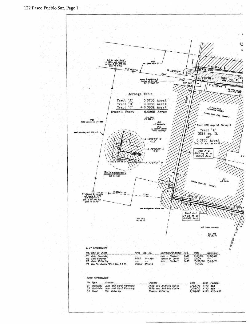
Tract 323
EX:C 297 PC325,P3
(OJ) § n/f Bsnavidies/McCorthy Family Ltd. Co.
comer of 2..:..story buHdlng rs O . .J'
outsfde su'*y boundary.
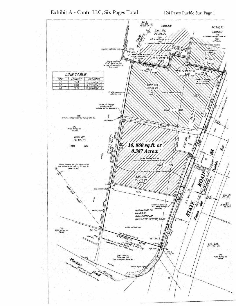
LINE TABLE LINE LENGTH BEARING
L1 3.65 s 77"57'04" £ L2 6.80 s 77"57'04" £ LJ 12.12 N 76"40'04" W
PC348, Pl
Tract 327
(Pt) RGSS survey no.
74-386
I
I I
I I
I
Exe. 285, PC 132, .Pl
!}9._Jip_e §.r~n_tgr_ __ ~---------_,.:... Qrga.t_e_p _ _, __ ,... :.....,.7""' __
DI Easement Northem Pueblos Agency, BIA Town of Taos 02 Spec.Warr. Mcparthy Enterpr;se~; Inc. Nan ·McCarthy, et al 03 Warranty Thomas and Barbara McCarthy Btmavfdl~s/McCarthy Family Ltd. c 04 Corr. Warr. Phi/Up -Cahtu, Sr .• ·et ux Phl'lllp· Cantu, dr., et, ux D5 Quitclaim Town of Taos Bent L.odge ·No. 42 · D6 R/W Tomas Archuleta, et ux Vi/loge of Taos D7 R/W Bent Lodge No •. 42 Vi/loge of Taos. DB Warranty John Ramming, et ux Phillip Cantu, Jr.; et ux
(P<) RGSS survey no,
L.f.154
DEED REFERENCES
James 0. CroM Jeffrey B. Sta< Milford T. kee; James 0. CroM Norman L. Kini Norman L. Kin;
!:!2._ JI.!/!_ er_ f!ff!..n_t ~ f!.trTJ.. __ J2£·_ !1£· 5_u.rr.eypf.LE_ngLr: Pl Saki Koravas · · RGSS 74~386 Jomes D. CroM P2 John McCarthy Irvin L. Sacked P3 Cantu · RGSS L3600 James D. Cro• P4 Doniel Baca RGSS L4154 Scott B. Crowl P5 US Publfc Worb NM Proj«t no. 57-8 (19:J5) sht.4 P6 Saki Korovae . RGSS R2420 Pl Mrs, J.A. · DesGeorges RB31 PB Private Claim Boundaries, TPG KS NM-23-84(17) P9 Helen Nanos to John Justus RGSS L1842-1 · Pio Private Claims Within the Taos Pueblo Grailt USGLO sht.218 P11- Prfvrite Claim~ ~ltbfn·. the Taos Putlb/6 Gront USGL.O shf.21C
comer of porch - TS 2.2' Inside SUr¥8)'
boundary.;· ~ius=11(J8.50 ;=99.50 lta=04"52'44' · ord=S19"13'10"W, 99.47
I ' I
I I
'
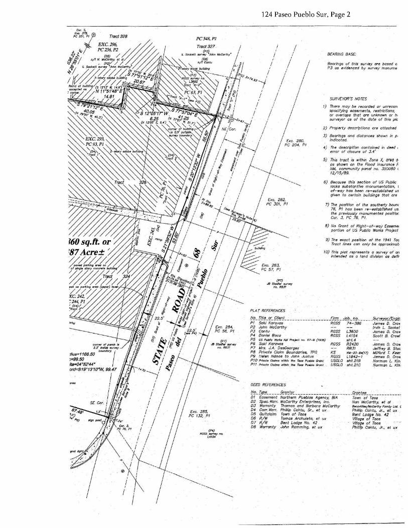
PLAT. REFERENCES
(P7) J8 S.todler survt1y
no. RQJf
10) This plat represents a survey of an in tended as - _a land division as. de fir
9) The exact position of the 1941 Tac Tract lines can only be approxlmot.
7} The position of the southerly bounc 76, Pl hos been· re=establlsned 'us. the previously monumented positior. Cor. 3, PC 76, Pl.
B) No Gr0nt of Right-of-way Easeme. portion of US Public Works Project
Exe. 2B2, PC .301, Pl
6) Because this section of· US Public lacks substantive rnonumeniation, 1 of-way has been re-established us given to certain bul/dings that are
5) This tract is within Zone X. orea o as shown on the Flood Insurance f.. NM, community panel no. 3500BO ( 12/15/B9.
2) Property aeecrtp tions ore attached
3) Bearings and distances shown in P• indicated.
4) The description - contained in deed 1
error· of closure ot 3. 4'
Exe. 2BO, PC 204, Pl
1) There may be recorded or unrecorc specffy;ng easements, restrictions, or overlaps that are unknown or h, surveyor as of the dote of this pie
I
I I
SURVEYOR'S NOTES I
Bearings of this surv'ey are based o ?3 as evidenced by survey inonume
BEARING BASE:
I I
I I
/ I
/ I
/ I
/ I
I I
NE/Cor. -i/ j t: ~'I I / -s / s-, •I ;1
fl §1 I
PC348,P1 Tract327
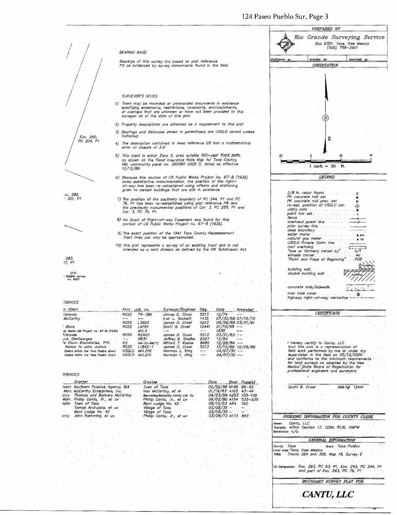
.-CANTl!,LLC BOUNDARY SURVEY PLAT FOR
Us D•slgnatlon' Exe. 293; PC 93, Pl, Exe. 242, PC 244,. Pl and part of Exe. 243, PC 76, Pl
COunty: ·Taos Grant: Taos Pueblo Loco/ arN: Taos, New Mexico TCRS: Tracts 324 and 326, Mop 18, Survey 2
GENERAL INFORMATION
Owner: Cantu, LLC Town•'* within Section 17, T25N, R13E, NMPM subdfvision: n/ a ·
NMLS# 12441 Scott B. Crowl
I hereby certify to Cantu, LLC that this plat is a representation of field work. performed by me or under my supervision in the field on 05/12/2000 and contorrns to the minimum requirements tor land surveys as adopted by the New }4exico~ rtat~ Board of Registration for profe~s1onaf engineers and surveyors. ..
CERTIFICATE
concrete slab/sidewalk
man hole cover. ® high W~IY righ t.;......of-way centerline ~ - - - -
building wall, double· building wall
• ng
~p-
0 • c
(£l ...
3/8 in. rebor found. PK concrete nail set PK concrete nail prev. set re-est. position of USGLO car. utility pole. point not set . fence overhead power line prior survey tine, deed boundary Water meter natural gas meter USGLO Private Claim line. roof overhang. ·~now. pr formerly owned by'.' witness comer. "Point and Place of Beginning~
LEGEND
1 inch = 20 ft.
40
I N 0 ~ 6 d I
ORIENTATION a rove¢ roofdd: /or droNilman: sc
Grande Surveying Service Box 6351, Taos, New Mexico
(505) 758-2901
PREPARED BY
"ERENCES
--~-2!'!.n_tg~------------~.--------J!!S!Qtep_~-------c-----~----P2l'l~---fl22is._.fggW;l_ nent Nortnem Pueblos Agency. BIA Town of Taos 02/02/96 Ml89 89-92 . Worr. McCarthy Enterprises, Inc. Nan McCarthy, ei al 01/19/83 A 165 '43-44 1nty Thomas and Barbara McCarthy 8.,,avldles/McCorlhy FomHy Ltd. Co. 04/23/99 A25j 105-106 Warr. Phillip Cantu, Sr., el ux Phillip Cantu, dr., et ux 06/02/80 Al54 533-535 :/aim Town of Taos Bent Lodge No. 42 08/10/53 A54 160
Tomas Archuleta, et ux Village of Taos 03/05/35 - Benl Lodge No. 42 Village of. Taos 03/05/35 -,
only John Ramming, et ux Phillip Cantu, Jr., el ux OJ/28/73.A/73 893
1/c Works NM Profe<jt no. 67-8 "{7935) '<drbvas J. A. .. DesGeorg~s 'e: Claim Boundaries, TPG Nonos to John Justus
r Baca
~r_.f!J~n_t ~ ;_ _ _flr_111 _ .l.E£.·_!J£·.;.. . _5_u_[y_8J'Ec/..£.!igLn.!_!C. _B~g_. J)_aJ~ """- __ -~f!l~.r!...d_eg __ (aravos RGSS 74-"386 James D: Crowl 5213 12/74 · McCarthy Irvin L. Sackett 1435 07 /30/68 07/15/70
RGSS L3600 Jomes D. Crowl 521J "09/29/89 OJ/21/91 RGSS L41$4 Scott 8. Crowl 12441 01/10/95. --
sht.4 1935 RGSS R2420 Jomes D. Crowl 521J 03/21/83 --
RB31 Jeffrey B. Stodle( 8327 12/84 KS NM-23-84(17) Milford T. Keene 8489 12/28/84 -- RGSS L1842-I Jomes D. Crowl 521J 12/15/89 12/28/89
Claims within th• Taos Pueblo Grant USGLO isht.218 Norman L. King 04/07 /32 -- . Cla!Ms Within th~ Taos Pueblo Grant USGLO sht.21C Norman L:., King 04/07 /32 --
oRENCES
(Pl) 1 Stadlv :survsy no: RB31
283, ;7, Pl
· 9) The exact position of the 1941 Taos County R8assessment Tract lines can only be approximated.
10} This plat represeais=a survey-of an existing tract and is not intended as· a land division as defined by the NM Subdivision Act.
7) The position of the southerly boundary of PC 244, Pl and PC 76, Pl has been re-established using plat reference PB and the previously monumented positions ·of Cor. J, PC 255, P1 and Cor. 3, PC 76; Pl.
8) No Grant of Right-of-way Easement was found for this portion of US Public Works Project no. 67-B (1935).
(C. 282, '301, Pl
6) Hecouse this section of US Public Works Project No. 67-B {1935) lacks subs tan ti Ve monumen tat ion, the position of the right of-way has- been re-established using offsets and stationing given to ceriotn tJu#dings- that are stilt in existence.
5) This tract is within Zane X, area outside 500-yeaf flood plain, as shown on the Flood Insurance Rate Map for Taos County. NM,· community panel no. 350080 0005 D, doted as effective 12/15/89.
4) The aescriptlon contained ln deed reference 05 has a mathematical error of closure of J. 4'
1) There may be recorded or unrecorded documents in existence specifying easements, restrictions, covenants, encroachments, or overlaps that are unknown or have not been provided to this surveyor as of the dote of this plat.
2) Property descriptions are attached as a supplement to this plat.
3) Bearings. and distances shown in parenthesis are USGLO record unless indicated. Exe. 280,
PC 204, Pl
SURVE:YOR'S NOTES
Bearings -9~ .thls survey or~ bosed on plat reference PJ as evidenced by survey monuments found in the field.
BEARING BASE- I
I
DECO REFERENCES
!!~._I:d>~ .9£~1J..ts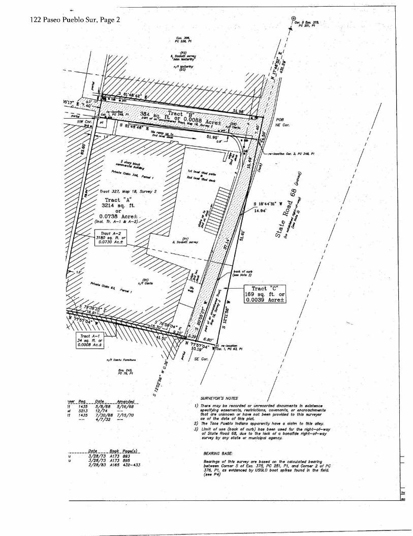
foe
I I
I
Bttorings of this survey are based on th& calculated bearing ·botw~en Comer 5 of £xc. J75, PC 25T, PT, and Comer 2 of PC J76, PT, as evidenced by USGLO boat spikes found in the field. (see P4)
8£AR/NG BAS£: .~ .P21.'!._~..;~J12g/!_fggfill_ u 3/28/73 AT73 893 u 3/28/lJ A173 895
2/28/8J A165 4-32-433
1) Th~re· may be recorded or Unrecorded documente tn existence spt1clfylng 11asements, restrictions, covenants, or encroachments thot are unknown or have not been provided to this survoyor as of th• dat• of this plat.
2) 111• Taos Pueblo Ind/ans apparently have a cialm to this alloy. 3) Limit of use (back of curb) has been used for the right-of-way
of Stat• Road 68, due to tho lack of a bonafido right-of-way survey by any siat« or municipal agtJncy.
I SURVEYOR'S NOTF:S !."!!:_ 1!!9.·_ - _ p_aJ!" -- __ 1ra!'1. q_.g_ - It 14-35 5/8/68. 5/T6/68 "' 5213 T2/74 It 1435 7/30/68 7/T5/JO
4/7/32
£Kc. 24-J. PC 76. Pl
I I
n/f Cantu _FUmltll,.. I I
Tract "c" 169 sq. ft. or 0.0039 Acre±
I I
I
I I
I ,.._1oco0m ¢#-. 2. PC Jofa. Pr
. (PJ)
'-.t:,,""~~f n/f(t°fr"Y
,, .. JOO. PC 2JI, Pl
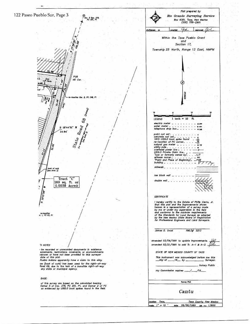
dote: 09 29 1989 Jcb. no.' LJ600 ....... 1·= 10 Taos Count New Mexico locotJon.: Taos
Cantu
Surwy Pfot
This lnStry.1ment was acknaw/9dged befOrfi "1e this _day of __ ,19_ by Surveyor.
------------~ Notary Public
my Commission exp/Nls __ /_/19 __
STA TC OF NEW MEXICO COUNTY OF TAOS
amended OJ/04/1991 to update lmprevements. ~. • amended OJ/21/1991 to add Tr. A-1 k A-2. ~
NMLS/ 521J James 0. Crowl
I hereby certify to the Estate of Philip Cantu, .k. that this plat and the improwtments shown hereon Is a represtmtation of a survey made by me or under my supervision In. the field and conforms to the mlnlmlm requirements of the Standards for Land surveys as adopted by the New Mexico State Board of Registration for Professional Engineers and Land Surveyors.
CERTTACATE:
double wall -~
~~
-------===== low block wall _ ···············
poiift riot s~h _ _ _ . _ _ _ concrete nan set_ . _ _ _ . . _ • 1915 USGLO boat spike found • -~ re-tocatton of PC comt1r_ _ _ • -\.a,., natural gas meter _ .. ._ _ _ . _ • ng utility pole_ _ _ _ _ _ _ _ _ _ _ • overhead power /in•- - - - - --P USGLO Private Claim //no_ _ _ ---~ "now or formeriy owned by: _ _ _ n/f witness comer • __ •. _ We "Point and Place of Beginning:_ _POB buUdlng_ _ ~
sidewalk
- . ""' - •Pm electric mettK -
water meter _ telephone drOp box_
Inch = 10 ft:· LEGEND
10 10
Within the Taos Pueblo Grant and
Section 17,
Township 25 North, Range 13 East, NMPM
"'
Plat prepared by Rio Grande Surveying Service
Box 6J51, Taos, New Mexfr:o (505} 758-2901
I I
I I
I
I I
I I
I
of this survey are based on thti calculated b~ring Comer 5 of E:cc. J75, PC 251, Pt, and Comer 2 of PC as evidenced by USGLO boat spikes found In the field.
BASE:
'be recorded or unrecofded documMts in t1xlstt1nce easements; r&strictions,· covenants, or encroachments
rnknown or have not been provided to this surveyor date of this plat. Pueblo Ind/ans apparently have a claim to this alley. ts« (back of curb) has been used for the right-of-way f?oad 68, due to the lack of a bonafide right-of-way any state or municipal agency.
I "s NOTES
I r.-locOtlon ir. 1, PC 6.t Pl
I Tract "C"
169 sq. ft. or 0.0039 Acre±
I
-1-tloo ~ 2. PC J~ Pl
@) I CDI". s Cn. 37~ r PC t51, Pl.