Embed Size (px)
Citation preview

ACCESSING A RIVERFRONT: REIMAGINING THE GEORGE WASHINGTON MEMORIAL 1PARKWAY AT ROSSLYN, VIRGINIA 2 3 4Paul Kelsch, Ph.D., Corresponding Author 5Landscape Architecture Program 6Virginia Tech, Washington Alexandria Architecture Center 71001 Prince Street, Alexandria VA 22314 8Tel: (703) 566-6701 Fax: 703.549.0532 Email: [email protected] 9 10J. Kris Krider, AICP 11Planning Supervisor, Arlington County Department of Community Planning, Housing and Development 122100 Clarendon Blvd. Suite 700, Arlington, VA 22201 13Tel: (703) 228-3310 Fax: (703) 228-3543 Email: [email protected] 14 15Jodi La Coe, RA, NCARB 16School of Architecture + Design 17Virginia Tech, Washington Alexandria Architecture Center 181001 Prince Street, Alexandria, VA 22314 19Tel: 814.753.0250 Fax: 703.549.0532 Email: [email protected] 20 21 22Word count: 5337 words + 8 figures x 250 words each = 7337 words 23
Kelsch, Krider and La Coe
2
Abstract 1This paper presents student proposals for redesigning the George Washington Memorial Parkway along 2the Rosslyn waterfront in Arlington, Virginia as a case study in university and community partnerships. 3The George Washington Memorial Parkway, a registered historic landscape, currently lines the entire 4riverfront in Arlington, Virginia, and precludes much pedestrian access to the river, especially in Rosslyn, 5the most densely developed area adjacent to the waterfront. Landscape architecture and architecture 6students from Virginia Tech’s Washington Alexandria Architecture Center examined the Rosslyn 7waterfront and proposed changes to the parkway as a means of accelerating community discussion about 8potential public access to the water. Six student projects are presented that engage the parkway in various 9ways, raising questions about historical integrity of the parkway and community access to the waterfront. 10The paper discusses Arlington County planners’ initial steps to engage a larger conversation about the 11work and the issues the projects raise. It concludes with discussion about the value and opportunities of 12university and community collaboration. 13 14Keywords 15George Washington Memorial Parkway, waterfront design, public access, historic landscapes, university 16community partnerships 17
Kelsch, Krider and La Coe
3
Introduction 1Arlington, Virginia has a problem that many communities would be happy to have: its entire Potomac 2River waterfront is a scenic parkway, the George Washington Memorial Parkway. The problem is that for 3all its beauty and historical significance, it has become a congested regional commuter route that renders 4much of the waterfront inaccessible to most pedestrian uses. To be fair, a popular multi-use trail, the 5Mount Vernon Trail, runs along several miles of the shoreline and a primitive hiking trail clings to the 6wilder edge of the Potomac gorge just upstream from Washington DC, but there is little opportunity for 7picnicking or other recreational uses that simply require a place to hang out or play. This is perhaps most 8keenly felt near Rosslyn, the most densely developed part of Arlington, a business district of numerous 9high-rise buildings and a conjunction of highways and mass-transit routes. Rosslyn lies immediately 10across the Potomac River from Georgetown, one of Washington’s most popular and historic 11neighborhoods with its vibrant, redeveloped waterfront and urban promenade reminding Arlingtonians of 12the potential of an accessible waterfront. The challenge for Arlington is that the G.W. Parkway, as it’s 13locally known, runs immediately adjacent to the waterfront in Rosslyn, making access to the water nearly 14impossible right where the greatest density of people work and live in close proximity to the river. 15
The parkway is not the only obstacle between Rosslyn and the waterfront. Interstate 66 traverses 16the site, mostly below grade, and several other surface roads connect Rosslyn to Francis Scott Key Bridge 17crossing the Potomac to Georgetown. Although there is substantial open space, it is crisscrossed by so 18many roads that the remnant parcels of land are virtually cut off from each other and from pedestrian use. 19Thousands of people pass through this landscape daily in vehicles, or on bicycles, or as pedestrians 20crossing the bridge to get to the Rosslyn Metro stop, yet virtually no one has a place to linger, even 21though it is a spectacular waterfront location in the heart of the nation’s capital. 22
Redeveloping the landscape is further complicated by the numerous entities with vested interest 23in its condition. The National Park Service administers the G.W. Parkway; the Federal Highway 24Administration has oversight for I-66; and entities, like the Rosslyn Business Improvement District, the 25Arlington County Parks Department, aswell as individual businesses, such as the adjoining Key Bridge 26Marriott, have a stake in the condition of the landscape and any potential changes to it. In short, these and 27many more constituencies, each with legitimate concern for what happens on the site, complicate matters 28as much as the existing roadways do. Proposals to change the status quo would no doubt stir up a lot of 29passion and concerns, creating additional challenges for Arlington’s urban planners and designers. 30
With these challenges in mind, Arlington urban designer Kris Krider teamed with Paul Kelsch 31and Jodi La Coe of the Virginia Tech landscape architecture and architecture programs, respectively, to 32see if Virginia Tech students could assist them in reimagining the Rosslyn waterfront. Krider explained it 33would be helpful to Arlington if the students explored the potentials of the site to show other designers, 34planners and community members what the site could become with some bold thinking about this urban 35landscape. This challenge became a great scenario for a design studio that explored the transformation of 36this landscape in order to open a community discussion about its potential for future public access and 37use. 38
This paper is a presentation of that design studio as a case study for how students can engage in 39creative scholarship as a catalyst for public discussion. Because of the impact of roads on the site, 40especially the G.W. Parkway, the paper focuses on schemes that propose alterations to the parkway, 41redesigning it to provide better public access to the waterfront while remaining sensitive to the existing 42context. After presenting the background of the project, including the existing conditions of the site and 43relevant history and design of the parkway, we will discuss the structure of the studio and present six 44projects that illustrate a range of responses to the parkway. Krider and his urban design team have already 45begun using the work to accelerate public discussion about the site, and we will present these first steps to 46show the kind of impact that the student work is having. Finally, we will reflect a bit about the merits of 47undertaking such an endeavor. 48
49

Kelsch, Krider and La Coe
4
1Figure 1 Aerial view showing Rosslyn waterfront and George Washington Memorial Parkway, 2015. 2
3Existing Conditions 4Rosslyn is a dense collection of high-rise office buildings sitting atop a bluff at a major bend in the Potomac 5River with fairly steep slopes descending toward the river on the north and east sides. (Figure 1) Major 6roads run parallel to the slopes except those leading to Francis Scott Key Bridge, which crosses the Potomac 7to access Georgetown. With limited land between it and the edge of the river, the G.W. Parkway runs along 8the edge of the Potomac River on dual roadways separated by a narrow grassy median. I-66 traverses the 9site adjacent to the business district of Rosslyn, dipping below grade to allow surface streets to cross at 10grade. Gateway Park, an underutilized, multi-level urban plaza, sits atop the highway and is connected to 11adjacent buildings with overhead walkways. The park is competently designed but the walls and stairs that 12elevate pedestrians above the adjoining streets hinder any visual connection to the waterfront. Several 13surface streets connect Rosslyn to Key Bridge, and collectively all these roads make a complicated network 14of slip lanes, city streets, parkway, and interstate highway. As a result, the land sloping northward down 15toward the river is fragmented into disconnected parcels, varying in size and content. Near the bridge and 16along the parkway they tend to have planted, maintained vegetation; whereas, in other places, they have 17remnants of woodland areas with invasive vines, all on rather steep slopes. The combination of heavy 18traffic, unmanaged vegetation and steep topography offers little appeal or opportunity for use other than on 19designated sidewalks and the Mount Vernon Trail, which begins at Key Bridge and heads almost twenty 20miles downriver to Mount Vernon. 21
22History and Precedent 23The confluence of roadways is a direct result of Rosslyn’s geography and history as a junction of 24transportation routes. For centuries, the bend in the Potomac River between Georgetown and Rosslyn has 25been an important crossing. That bend marks the threshold between free-flowing, fresh water and tidal, 26brackish water, an ideal place to settle where potable water meets navigable water. (1) Because of the 27favorability of this location, Georgetown was among the earliest settlements along the river, and ferries 28connected it to Virginia as early as 1737. By the early 1800s a causeway connected neighboring Mason’s 29

Kelsch, Krider and La Coe
5
Island to the Virginia shore at Rosslyn, and it became a stepping stone in the ferry crossing. (2) Since then 1numerous crossings have been constructed, each of them touching down in the same vicinity. The 2Alexandria Canal Company’s Aqueduct Bridge spanned the river in 1843 allowing canal boats to connect 3with the Chesapeake and Ohio Canal; and, just prior to the Civil War, the first railroad line reached 4Rosslyn, presumably to transport goods to and from the canal. This was a vulnerable crossing during the 5Civil War, and Union troops occupied William and Carolyn Ross’s adjacent farmland to protect the 6bridge. In 1888, a new superstructure was built on the bridge, allowing pedestrians and carriages to cross, 7too. (3) 8 9
10Figure 2 Aerial view showing Aqueduct Bridge and Key Bridge, c. 1930 11 12
During the twentieth century, this nexus of canal, rail and roads transformed into modern 13infrastructure. In 1912, the Washington and Old Dominion electric railroad replaced the earlier train line, 14leading the way to the suburbanization of Arlington County. The Aqueduct Bridge was removed in 1933, 15after its replacement with the Francis Scott Key Bridge, which carried trolleys from Georgetown to 16Rosslyn, allowing passengers to transfer to the Washington and Old Dominion line. (Figure 2) (3) Since 17its completion in 1923, Key Bridge has been expanded numerous times, its first addition in 1939 an extra 18

Kelsch, Krider and La Coe
6
supporting arch on the Rosslyn side to allow the new G.W. Parkway to pass underneath it. With later 1additions it now carries six lanes of traffic plus pedestrians and cyclists on adjoining sidewalks 2cantilevered off the main deck. (4) 3
Modern Rosslyn began to develop in the 1960s, including plans for an interstate highway. Before 4the highway was completed, however, a new metro line opened in 1975, crossing under the river and 5connecting Rosslyn directly to downtown Washington. When I-66 opened two years later, there were 6three important crossings between Rosslyn and Washington all crossing the Potomac within a short 7distance of one another. Currently, a second Metro tunnel and a gondola crossing are being considered, 8potentially adding even more transportation infrastructure to a landscape already largely defined by it. (3) 9
In this context, Krider’s desire to make the site more accessible for public use seems to be fighting 10the trajectory of history, but there is good precedent in the design of the G.W. Parkway itself for combining 11public use with a parkway. The parkway’s original segment, the Mount Vernon Memorial Highway, was 12the first federally-built parkway and commemorated George Washington’s 200th birthday by making a 13beautiful and dignified pilgrimage route to his home at Mount Vernon. It transformed railroad yards, 14swamps, woodland, and gravel quarries of the Virginia riverfront into a picturesque landscape for fifteen 15miles leading to Mount Vernon; and, for the first time, the river became accessible to the public with scenic 16pullouts, picnic areas and developed parkland along its length. (5) The project was so popular that, even 17before it was finished, Congress authorized a much bolder vision to expand it to include both sides of the 18river from Great Falls, fifteen miles upriver, to Mount Vernon, fifteen miles downriver. The larger parkway 19was renamed the George Washington Memorial Parkway, and the first extended section was built past 20Rosslyn in 1939. 21
The design of the original Mount Vernon Memorial Highway differs in important ways from the 22later segments of the George Washington Memorial Parkway, and this older design offers insight into the 23challenges facing Rosslyn today. (6) The southernmost section of the design is still largely intact from 24Alexandria to Mount Vernon, and it is easy to see how the design links the roadway to its adjoining 25communities. (7) Unlike most later parkways, including the northern segments of the G.W. Parkway, the 26Memorial Highway deliberately cultivated a sense of connection to its neighboring communities and the 27waterfront. Each segment has its own character, responding to the varying site conditions, and in several 28sections, new secondary roads were designed alongside the main roadway, so that new housing would be 29built facing the parkway across communal park space rather than turning away from it. A continuous 30walking path was proposed along the river side of the roadway with a matching bridle trail on the inland 31side, and these connected a set of picnic areas, marinas, overlooks, and bus shelters, the latter allowing 32residents to use the parkway to travel to and from Alexandria and Washington. The road itself utilized a 33single, forty-foot roadway to keep a relatively narrow footprint, and it was graded to follow the existing 34topography with most intersections occurring at grade. All of this gives the original segment of the parkway 35a more domestic and community focused character, and any nice weekend the landscape is literally 36saturated with people. 37
By contrast, the George Washington Memorial Parkway heading north from Rosslyn is a more 38modern design with dual roadways, extensive cut and fill, grade separated interchanges, limited access, and 39sweeping curves that flow through a continuous swath of open, grassy space bordered by dense forest. (8) 40It was literally the textbook example of modern roadway design, illustrated with a photograph taken from 41atop Key Bridge showing the two roadways diverging as they ascend the bluffs of the river and fit into the 42complex topography. (5) It is a strikingly beautiful design. However, for all the undeniable beauty of its 43sweeping curves and continuous flowing space, the more modern design of the G.W. Parkway did not seek 44to engage the communities along its length. There are occasional scenic overlooks and access points for a 45trail at the river’s edge, but otherwise there is little opportunity for non-drivers to experience this 46extraordinary landscape. 47
The parkway segment along the Rosslyn waterfront fits neither of these scenarios, in part because 48it was constructed as a strategic link between the original Memorial Highway and the future segments of 49the G.W. Parkway. It is shoe-horned between the steep bluff of Rosslyn on one side and the water’s edge 50on the other as it rounds the prominent bend of the Potomac River. Its design seems more constrained by 51

Kelsch, Krider and La Coe
7
its site than the other segments, and this may be indicative of the fact that it’s the only segment of the 1parkway which had not been studied as part of a National Park Service Cultural Landscape Inventory. Like 2the other segments, it presumably is historically significant for reasons associated with the planning and 3preservation of the Potomac River and for its association with George Washington, but its design is arguably 4less significant than the other segments. (9) The challenge in creating more public access to the Rosslyn 5waterfront was to reimagine the G.W. Parkway in ways that integrated people into the landscape with the 6same kind of thoughtful design that characterized the earlier design. How do we reimagine this segment of 7the parkway landscape being focused as much on public use as it does on scenic driving? 8
9Civic and Educational Partnership 10In September 2015, the Arlington County Board adopted the Rosslyn Sector Plan, the first such update in 11over two decades. As part of the implementation guidance, one key recommendation of the plan was to 12explore opportunities to improve the waterfront and nearby Gateway Park and create a vision with economic 13development, recreation, open space and multi-modal transportation benefits. Tasked by Steve Cover, 14Director of the Department of Planning Housing and Development, the Urban Design and Research section 15sought assistance from the Virginia Tech Washington Alexandria Architecture Center. Staff sought a 16collaboration with landscape and architecture faculty, Paul Kelsch and Jodi La Coe, to develop a semester 17long program for students to analyze the existing conditions and history of the site, explore a wide variety 18of conceptual solutions and engage county leadership in a thought provoking dialogue. For Arlington 19County, goals included supporting the implementation of the Rosslyn Sector Plan, achieving a body of 20work to further the mission of the Center for Urban Design and Research and to educate the Arlington 21leadership and community on the value and impact of high quality urban design, architecture and landscape 22solutions. By utilizing an academic exercise, we were unencumbered of the need to develop an extensive 23scope, consultant selection and civic engagement process which requires extensive resources and time. The 24overarching goal was to unleash a series of ideas and design concepts for consideration by federal agencies 25and stakeholders who have oversight and ownership of the Rosslyn waterfront. 26 27Structure of the Design Studio 28Design studios at Virginia Tech’s Washington Alexandria Architecture Center have a distinct structure that 29influenced the way we ran the studio. Whereas most design studios in architecture and landscape 30architecture programs are comprised of students in a single discipline and at a common academic level, the 31Washington Alexandria Architecture Center is a consortium of design schools from around the country and 32around the world; and our studio reflected this diversity with a mix of landscape architecture and 33architecture students, graduate and undergraduate students, and Virginia Tech students and students from 34other universities. The scope of the project fell more comfortably within the realm of landscape architecture; 35but we were confident that the architecture students would offer important insights into the overall 36investigation of the site and the charge to improve access to the waterfront. 37
Many public landscapes do not have programmed activities so park visitors can use the land as they 38desire, most buildings do have a specified use, and we thought it important to define three potential 39programs to guide the students’ work. Each of the three programs included a way to access the site and 40some activity to do while there. Each was intentionally vague such that the students would need to interpret 41their selected program to fit the site and their design intentions. The three programs were: 42
43o “Bike, Bathe and Beyond,” a place for bathing (showering, swimming, etc.) connected to 44
bicycling (commuting, recreational riding, etc.) 45o “Food-Boat Wharf,” a place where future food-boats could moor along the river’s edge and 46
sell their products to Rosslyn workers and others looking for a waterside lunch. 47o “Urban Drive-In Theater,” a place where people could arrive by foot, bike or car to view movies 48
or other outdoor performances. 49 50

Kelsch, Krider and La Coe
8
At their simplest level, the programs include common activities in public spaces – engagement with 1water, eating and people-watching – and common modes of travel – walking, bicycling and driving. Each 2student accommodated these activities in distinctive ways, but the activities themselves are really quite 3traditional. 4
In the outset, we established a tighter structure to the studio, and increasingly encouraged students 5to direct their own design inquiry. We assigned a series of exercises requiring the students to engage the 6site directly and then to place it in larger contexts. Based on these initial investigations, they hypothetically 7manipulated the topography by cutting and filling the earth in order to introduce some aspect of one of the 8programs onto the site. All of this was aimed at evoking ideas and helping the students establish directions 9for themselves. At this point, the students presented their work to Kris Krider and his colleagues from the 10urban design team, Brett Wallace and Justin Falango, who provided feedback and encouraged each of the 11students to be bold and imaginative in their designs. Collectively the urban design team was consistent in 12their encouragement of the range of ideas and did not try to steer the projects in a particular direction; and, 13by the midpoint of the semester, each student had determined a program for the site and a design strategy 14to pursue and develop in more detail in the second half. Given the complexity of the site, each student 15necessarily focused on a portion of it and with a particular emphasis. Each student, in effect, established 16his or her own project within the overall charge to reimagine the connection between Rosslyn and the 17waterfront. 18
19Design Studio Stakeholder Engagement 20With a design program in place for the project, the studio began with the students working in teams to draft 21site cross sections through the landscape and roadway network and to individually analyze environmental, 22historic, development and cultural impacts on the site area. They also researched historical documents 23related to the construction of the G.W. Parkway, evolution of the waterfront and base mapping files sourced 24by Arlington County. 25 26Following site visits, students presented their initial analyses and preliminary design concepts in early 27February 2016. This served as an opportunity for Arlington County urban design staff to offer suggestions 28for further design exploration and share their vision to transform the waterfront from an inaccessible 29landscape of highways and remnant land parcels into an accessible, recreational destination while re-30introducing a more environmentally sustainable landscape supporting habitat, native species and improving 31water quality. 32 33For the benefit of stakeholders and the students, a rotating project critique was held in late February with 34guests including the National Park Service and National Capital Planning Commission, senior county staff 35from planning, economic development, parks, and transportation, adjoining property owners, members of 36the Ballston Business Improvement District, planning commissioners and members of the design 37community. Each student made brief presentations and every 20 minutes, teams of reviewers would move 38from one project to the next, giving each student 4-5 opportunities over three hours to express their ideas, 39orient the reviewers and gather feedback from a variety of perspectives. 40 41In early April, the urban design staff offered a mid-term review of each student’s primary concept with a 42goal of getting more resolution from their investigations and to focus on the stronger ideas for a final 43concept design. This was followed by a final open house in May, when previously invited guests returned 44for a more informal drop-in presentations and one-on-one conversations to allow students to describe their 45major design gestures. 46 47To bring closure to the studio effort and introduce the project to the broader public, the urban design staff 48invited Kelsch and La Coe to Arlington County’s monthly Design Lunch to describe the results and view a 49public gallery display of all of the student’s presentation drawings in early June. County staff has also 50created a web site, which features the student work. (10) The studio results have been shared with 51

Kelsch, Krider and La Coe
9
consultants studying the feasibility of a gondola traversing the study area and connecting Georgetown to 1the Rosslyn Metro station. Follow up steps include a presentation to federal agencies and property owners 2considering redevelopment in the study area. 34Proposals 5The projects varied widely, and we present six that represent a range of approaches to the redesign of the 6G.W. Parkway. Four are landscape architecture projects and investigate the possibility of moving the 7parkway onto a causeway in the river; cutting it into the slope farther from the edge; elevating it; and leaving 8it as is, but working around it. Two architecture projects investigate the possibilities of using architecture 9to bridge over the parkway or to tunnel under it. The six projects are presented here as a gallery of their 10work. 11 12
13Figure 3 Ian Hunter’s proposed causeway shelters a publicly accessible lagoon. 14 15A new causeway, Ian Hunter. 16Ian Hunter transformed the waterfront by proposing a new causeway for the parkway that encloses a lagoon 17and allows for more intimate contact with the water. (Figure 3) There is historical precedent for such a bold 18move in the original design for the Mount Vernon Memorial Highway which utilized causeways to span 19the mouths of four streams, making lagoons of each. In Hunter’s proposal, a small stream runs down a 20narrow ravine and then flows into the lagoon, where a protected beach would allow children to wade safely 21in the water and kayakers to launch boats and explore the river. The causeway itself extends across shallow 22water, rising onto piers where the water is deeper, and aligns through the second arch of Key Bridge. New 23exit ramps connect the roadway to the traffic on the upper level, and the site of the existing roadway is 24regraded for a variety of park uses along the new, protected waterfront. Berms along the new roadway and 25solid guardrails would screen the noise of the cars, so they would be visible but not audibly intrusive. 26 27 28

Kelsch, Krider and La Coe
10
1Figure 4 Paige Courtney’s proposed natural swimming pool is fed with filtered storm water. 2 3A natural swimming pool, Paige Courtney. 4Paige Courtney proposed relocating the parkway farther inland, cutting it into the slope with a large 5retaining wall so she could use the former roadbed for innovative storm water management and a natural 6swimming pool along the waterfront. (Figure 4) She channeled a small tributary flowing down the hillside 7and into a filtering wetland along the former westbound lane of the parkway. She sized wetlands to collect 8and filter storm water sufficiently enough for safe swimming in two successive pools, one for lap swimming 9and one for family swimming. A small waterfall plunges from the upper pool into the lower one where 10children can play in it as it cascades into the shallower basin. The former eastbound lane of the parkway 11provides vehicular access and parking for the new facility. 12 13A theatrical landscape, Lauren Habenicht Arledge. 14Lauren Habenicht Arledge studied the theatricality of the existing parkway, especially its sequence of 15dramatic views of the Potomac River and the monuments of Washington DC, and she proposed an equally 16theatrical landscape. By elevating a stretch of the parkway, she set up a dramatic view from the new 17highpoint of the road and transformed the adjoining landscape into a series of terraces with cascading pools 18stepping down to the river’s edge. (Figure 5) The various terraces provide opportunities for active and 19passive recreation, including a soccer field, basketball court, and areas for picnicking and just hanging out 20in small groups. She conceived of the smaller terraces as box seats from which the sports activities, the 21Georgetown waterfront, and even the passing cars could all be viewed and appreciated. The roadway is 22elevated high enough to allow spacious and comfortable access to the waterfront where water taxis, food 23boats, and other boats could moor and provide service to the office workers up the slope in Rosslyn. 24 25

Kelsch, Krider and La Coe
11
1Figure 5 Lauren Habenicht Arledge’s terraces step toward the river beneath a newly elevated parkway. 2 3 4
5Figure 6 Carlin Tacey’s proposed pedestrian bridge provides a view over more natural landscapes. 6 7A wilder roadway experience, Carlin Tacey. 8Carlin Tacey was inspired by existing moments of contrast at the site between wild vegetation and the 9constructed landscape. For her the parkway was not an obstacle but an opportunity for greater experience 10of those contrasts, so she proposed meadows and wilder woodland in the medians of the parkway, and 11developed a sequence of spaces and paths that would lead people to the waterfront through an alternating 12series of wild and constructed places. (Figure 6) For example, she attached a pedestrian bridge directly to 13the existing on-ramp of the parkway, so that pedestrians would experience the intensity of the roadway 14from a unique vantage immediately after emerging from the enriched woodland. Her goal was to accentuate 15

Kelsch, Krider and La Coe
12
the experience of both places, leading to a sense of sublime awe in anticipation of arriving at the shoreline, 1itself framed between the Potomac River and the lower level of the parkway. 2 3 4
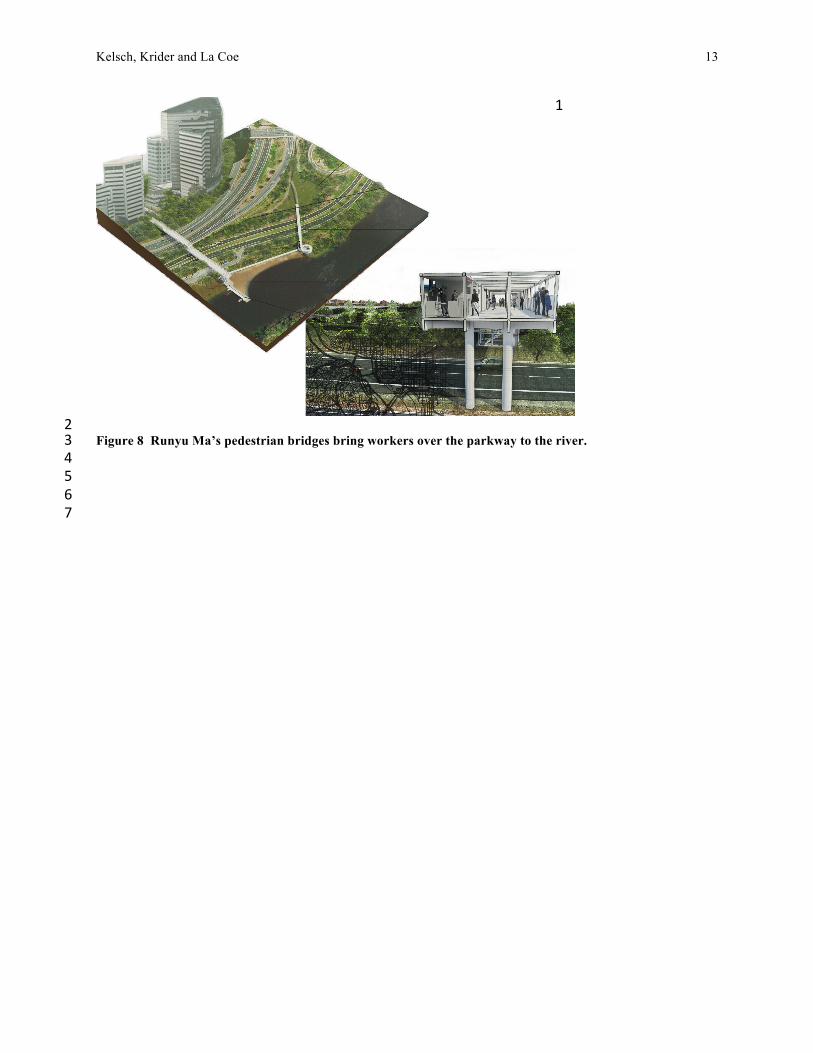
5Figure 7 Will Scott’s proposed bathing facility sits underneath the elevated parkway. 6 7Showering under the parkway, Will Scott. 8Will Scott shifted the parkway inland where it would sit higher up the slope, allowing him to construct a 9bathing facility for bicycle commuters underneath the parkway. Cyclists would be able to ride to Rosslyn 10on the Mount Vernon Trail, store their bikes, shower, and make their way through an ascending set of 11courtyards and new buildings to reach the commercial heart of Rosslyn. The large piers of the elevated 12parkway would give the showers and locker facilities an industrial scale in notable contrast to the human 13scale of the bathers. A set of four conical stair towers allow pedestrians to cross over other roadways and 14then descend to ground level making a sequence of above ground, at-grade, and below ground spaces 15connecting the commercial district to the river. 16 17A pop-up commercial bridge over the parkway, Runyu Ma. 18Runyu Ma proposed a pair of long pedestrian bridges over the parkway to make a continuous walking loop 19from the Rosslyn commercial district to the river and back. The larger bridge is a structural frame designed 20for pop-up retail spaces, and it terraces down the slope in large steps with service cores at each of the level 21changes. The axis of the bridge extends into the river as a jetty, where it would collect sediments and form 22a natural beach on the upriver side. Water taxis and food boats would be able to dock on the downriver side 23to service the business community of Rosslyn. The second, smaller bridge has a gentle slope and a spiral 24access ramp so it can accommodate bicycles from the Mount Vernon Trail in addition to pedestrians. Storm 25water is also filtered on it and carried across the parkway in a small channel culminating in a waterfall at 26the edge of the river. 27 28
Kelsch, Krider and La Coe
13
1
2Figure 8 Runyu Ma’s pedestrian bridges bring workers over the parkway to the river. 3 4 5 6 7

Kelsch, Krider and La Coe
14
Conclusion 1These six proposals for redesigning the G.W. Parkway would each need tremendous 2development if they were to be implemented; and each, no doubt, would meet resistance from 3the very constituencies that have much at stake in the current design of the parkway. But 4implementation and practical solutions are not the point of this work. As stated earlier, these 5projects are intended to accelerate conversations about the relationships between the roadway, 6the water and the community. 7
On one level, they would seem to raise questions about acceptable change with regard to 8the historic roadway. Each proposes significant changes to the roadway, but many of them have 9precedence in the design of the Mount Vernon Memorial Highway or its extension into the 10George Washington Memorial Parkway. Ian Hunter’s causeway is reminiscent of the four 11causeways built for the Mount Vernon Memorial Highway, and Paige Courtney’s large retaining 12wall mimics those found on the final segment of the parkway, now called the Clara Barton 13Parkway. Various bridges have been added over the parkway, so bridging proposals also have 14precedence. True, none of these conditions occurred in this section of the parkway, which raises 15questions about the historical integrity of this actual design versus the original intention of the 16Memorial Highway to integrate community into the parkway landscape. By proposing a bold 17redesign of the parkway, but with precedents in other parts of the parkway, these designs open 18that discussion. 19
On another level, they give evidence of the kind of input students can have in a project. 20Landscape architecture programs regularly get requests from communities or organizations 21seeking design help, often along the line of, “Wouldn’t our project be great for your students?” 22Typically, the projects are indeed good projects, and the communities merit assistance. The 23problem is that design studios are better suited to explore a problem than resolve it. In most 24studios, students work individually on projects or in small groups; and, therefore, it is easier to 25produce fifteen or twenty schemes than it is to have one implementable scheme for a community. 26When Kris Krider suggested that students investigate the Rosslyn waterfront and propose 27schemes that would catalyze discussion about accessing the river, he tapped into the collective 28ability and strength of a design studio. In this case, the students’ lack of professional constraints 29was specifically valued and encouraged over the course of the semester; and, in turn, they were 30inspired to know their insights were going to matter. They felt they had something to offer as 31well as something to learn. 32
Overall then, the value of the students’ projects is precisely that they are not pragmatic 33responses. Rather, they constitute a body of creative scholarship, a collective investigation of site 34conditions, historical context and imagined futures. It is this combination of analysis and 35speculation that is their real value, and their work exemplifies the potential of such collaborative 36work between universities and communities or public organizations. 37
38 39

Kelsch, Krider and La Coe
15
REFERENCES 11. Spirn, A. W. The Granite Garden: Urban Nature and Human Design. Basic Books, New York, 2
1984. 32. National Park Service. Cultural Landscape Inventory: Theodore Roosevelt Island. National Park 4
Service, Department of Interior, Washington DC, 2010. 53. McCormick Taylor, Inc., Engineers and Planners. “A Historic Landscape Template for the 6
Rosslyn Circle and Promontory, Rosslyn, Arlington County, Virginia”. Unpublished report 7prepared for Arlington County, VA. Undated. 8
4. “Key Bridge (Washington, DC). https://en.wikipedia.org/ wiki/Key_Bridge_(Washington,_D.C.) 9Accessed July 25, 2016. 10
5. Davis, T. “Mount Vernon Memorial Highway: Changing Conceptions of an American 11Commemorative Landscape” in Wolschke-Bulmahn, ed. Places of Commemoration: Search for 12Identity and Landscape Design. Dumbarton Oaks: Washington DC, 2001. 13
6. Kelsch, P. “Cultivating Modernity, History and Nature: The Planting Design for the Mount 14Vernon Memorial Highway”, Studies in the History of Gardens and Designed Landscapes. 31:4, 15294-310, 2011. 16
7. National Park Service. Draft: Cultural Landscape Inventory: Mount Vernon Memorial Highway -17- South. National Park Service, Department of Interior, Washington DC. (Research completed 182013, by Kelsch.) 19
8. National Park Service. Cultural Landscape Inventory: George Washington Memorial Parkway -- 20North. National Park Service, Department of Interior, Washington DC, 2009. 21
9. National Park Service. National Register of Historic Places, Registration Form: George 22Washington Memorial Parkway. National Park Service, Department of Interior, Washington DC, 231995. 24
10. https://projects.arlingtonva.us/planning/urban-design/student-work/vt-waterfront/. 25


![Alexandria gazette (Alexandria, Va. : 1834). 1857-02-03 [p ]](https://img.pdfslide.us/doc/110x75/6196893d14c96f0e137d522d/alexandria-gazette-alexandria-va-1834-1857-02-03-p-.jpg)