Embed Size (px)
Citation preview

The Regents of the University of Colorado, a body corporate, contracting on behalfof the University of Colorado at Boulder for the benefit of INSTAAR
Patterned Ground Formation and Description as Suggested by Low Arctic and SubarcticExamplesAuthor(s): Frank H. NicholsonSource: Arctic and Alpine Research, Vol. 8, No. 4 (Nov., 1976), pp. 329-342Published by: INSTAAR, University of ColoradoStable URL: http://www.jstor.org/stable/1550437 .
Accessed: 15/06/2014 12:42
Your use of the JSTOR archive indicates your acceptance of the Terms & Conditions of Use, available at .http://www.jstor.org/page/info/about/policies/terms.jsp
.JSTOR is a not-for-profit service that helps scholars, researchers, and students discover, use, and build upon a wide range ofcontent in a trusted digital archive. We use information technology and tools to increase productivity and facilitate new formsof scholarship. For more information about JSTOR, please contact [email protected].
.
INSTAAR, University of Colorado and The Regents of the University of Colorado, a body corporate,contracting on behalf of the University of Colorado at Boulder for the benefit of INSTAAR are collaboratingwith JSTOR to digitize, preserve and extend access to Arctic and Alpine Research.
http://www.jstor.org
This content downloaded from 62.122.79.21 on Sun, 15 Jun 2014 12:42:37 PMAll use subject to JSTOR Terms and Conditions

Arctic and Alpine Research, Vol. 8, No. 4, 1976, pp. 329-342 Copyrighted 1976. All rights reserved.
PATTERNED GROUND FORMATION AND DESCRIPTION AS SUGGESTED BY LOW ARCTIC AND SUBARCTIC EXAMPLES
FRANK H. NICHOLSON
McGill Sub-Arctic Research Laboratory (and Department of Geography, McGill University)
P.O. Box 790 Schefferville, Quebec GOG 2TO
ABSTRACT
A modified system of patterned-ground field de- scription was developed following observations in eastern England, northwest Alaska, and north Nor- way. Four major criteria were used: pattern surface form (equiform, elongate, stripe, step); pattern group- ing (isolated, semigrouped, contiguous); pattern marking (relief, stone, vegetation); and pattern size. Field evidence of movements in the patterns, mainly from large excavated sections, is presented, which indicates movements downwards and inwards from beneath pattern margins and upwards in the pattern centers. These movements are believed to be mainly due to inclined freezing fronts, the consequent stress pattern and the relative compressional and tensional
strengths of frozen ground. The movement towards the center at depth, together with well-known pattern movements, indicates a circulatory model of move- ment of fines. An approximately radial model of movement for sorting is envisaged. If the two models are combined, the development of many forms of patterned ground can be explained. A tentative hypothesis for pattern initiation suggests that, under critical conditions, pattern centers, which are centers of greater than average heaving, subdue heaving in the margins. These marginal areas of subdued heaving in turn encourage greater heaving a unit distance away, hence triggering new units at regular intervals.
INTRODUCTION
Between 1963 and 1967, I carried out extensive studies of fossil patterned ground in East Anglia, United Kingdom, and of active patterned ground in the Seward Peninsula, Alaska, and in Finnmark, north Norway (Nicholson, 1969). In East Anglia pattern sites were mapped in detail over an area of 2500 km2. In the Seward Peninsula and Finnmark specimen areas were mapped. On the ground hundreds of sites were
visited, described, and, when possible, quantified. Large sections were excavated in East Anglia using a backhoe and in the Seward Peninsula and Finnmark with the aid of explosives. These observations, brief observations in other areas, and a review of published descriptions of patterned ground in the light of the observations, suggested shifts in the emphasis to be placed on various ideas concerning patterned ground.
FIELD DESCRIPTION OF PATTERNED GROUND
No existing system of patterned-ground description was found to be wholly satisfactory when applied to many sites, and special modifications were often needed. The following system was devised for the description of as many occurrences as possible with- out the use of special descriptive terms (specific to particular sites). It avoids enforced use of genetic descriptions which might have to be changed as more
evidence becomes available and makes field descrip- tion as simple as possible while maintaining a maximum of useful information. In accordance with their accepted definitions, accepted terms were used whenever possible.
Patterned ground is recognized when some surface variation marks approximately regular units that are repetitive in form and size. The individual units may
F. H. NICHOLSON / 329
II
This content downloaded from 62.122.79.21 on Sun, 15 Jun 2014 12:42:37 PMAll use subject to JSTOR Terms and Conditions

TABLE 1
System of patterned ground description
Description of form equiform elongate stripe step (other)
Description of grouping isolated semigrouped contiguous
Description of pattern marking (variations of) relief
(variations of) stone (variations of) vegetation (other variations)
Pattern unit size
Note: The descriptive terms can conveniently be used in conjunction with each other, e.g., isolated stone steps; contiguous vegetation elongates.
be contiguous and regularly arranged in relation to one another or they may be isolated with no regular ar- rangement. Four criteria seem most useful for descrip- tion: the surface form of the pattern (stripe, step, etc.); the grouping of the units of the pattern; the feature that is varying and thus marking the pattern on the ground (vegetation variations, stone variations, etc.); and the size of the pattern. These can be assem- bled into a general scheme as shown in Table 1.
DESCRIPTION OF SURFACE FORM Equiform. Equiforms are patterns with a surface form that is equidimensional in several directions. As illus- trated in Figure 1, the term "equiform" is intended to include circular and regular polygonal shapes, and shapes intermediate between the two, for which the term "net" has been used (Washbur, 1956). The use of the term equiform removes the need for the term net, which has special definition problems. The term avoids difficult field decisions on the distinction be- tween circles, polygons, and intermediate forms. In all field areas, intermediate forms were seen very much more frequently than patterns which were unequivocally circles or polygons. With the term equiform available the terms circle and polygon can be reserved for equiforms marked by unequivocal circles and polygons. The term equiform removes the de- scriptive problem that theoretically the unit bound- aries of all contiguous equiforms are polygonal (see also Figure 1). The term equiform is believed to be a new word which is geologically, geometrically, and etymologically acceptable.
Elongate. Elongates are patterns with marked elonga- tion of the pattern unit, but not indefinite elongation. Elongates are distinguished from equiforms by their
FIGURE 1. Examples of equiforms. (a) Shows isolated equiforms and (b) to (f) show contiguous equiforms: (b) and (c) are unequivocal polygons and circles, respectively. Oc- casional field examples show clear circle and polygon shapes in the same unit, as shown in (f), seen near Russenes, Finnmark.
elongation. They are distinguished from stripes in that the division into units in the direction of elongation is an essential feature. The term is proposed to describe a form of pattern found to be common in the field and on air photographs. Previous authors have commented on the existence of forms intermediate between equiforms and stripes (Troll, 1944; Washburn, 1947; Hopkins and Sigafoos, 1951; Philberth, 1964; Wil- liams, 1964). The division between long elongates and stripes is sometimes difficult in the field, but is valid since clear examples of very long elongates have been seen. However, only a small percentage of elon- gates have a length:width ratio greater than 10:1 and it is suggested that, to avoid confusion, such examples should always be qualified as "long" elongates.
Stripes. Stripes are linear patterns without any inter- ruption of the linear form, excepting those interrup- tions which are not an essential part of the repetitive pattern. Stripes are oriented in a general downslope direction. While they are commonly perpendicular to the contours, they sometimes cross the contours at
330 / ARCTIC AND ALPINE RESEARCH
This content downloaded from 62.122.79.21 on Sun, 15 Jun 2014 12:42:37 PMAll use subject to JSTOR Terms and Conditions

FIGURE 2. Specimen area of patterned ground mapping from aerial photographs East Anglia, U.K. Contour interval 25 ft (7.5 m), grid lines at 1-km intervals. Some 2500 km2 were mapped, this area showing a particularly dense coverage of patterns. Some striking examples of stripes not aligned perpendicular to the contours are arrowed. Stripes tend to follow the subsurface drainage direction rather than the steepest surface gradient.
angles much less than 90? (Figure 2) and often small divergencies are found if sites are surveyed in detail.
Steps. A step is a form on a slope where an area of ground less steep than the general slope is bounded downslope by a margin notably steeper than the gen- eral slope. In a general way steps resemble "steps" in the normally accepted sense. Clear cases of contigu- ous steps that graded in other forms of patterned ground were observed. On the other hand there is no doubt that there is every grade from steps that are clearly patterned ground forms to a variety of mass movement forms that are definitely not patterned ground (Benedict, 1970) and currently no good criteria are available for defining the limit of the term steps in this respect.
DESCRIPTION OF PATTERN GROUPING Isolated patterns have units that are widely spaced and appear to only rarely, if ever, touch one another. Semi-grouped patterns have units that are arranged so that there is a suggestion of a regular repetition, with the units apparently touching in part, but not covering the entire area.
Contiguous patterns have units that appear to touch one another so that an entire area is covered.
DESCRIPTION OF PATTERN MARKING In recent years the system proposed by Washburn
(1950, 1956), using the descriptive terms sorted and nonsorted, has been dominant (Jahn, 1968). Sorting is a well-accepted genetic process and therefore is in- terpretive as well as descriptive and thus the term is unsatisfactory for purely descriptive purposes. Evi- dence of sorting has been observed by the author in sections in many patterns that often have little or no stone visible at the surface and which would be de- scribed as nonsorted by Washburn (1950, 1956), and similar examples have been reported by other authors. Sorted patterns that pass laterally without a break into nonsorted patterns have been reported in the literature and I saw a striking example of 9-m vegetation equiforms passing laterally to 9-m stone equiforms in the Seward Peninsula. Thus the use of terms implying major genetic differences seems unjustified in these cases (cf. Lundqvist, 1949; Jahn, 1975). The nega- tively defined term "nonsorted" is not very useful for
F. H. NICHOLSON / 331
This content downloaded from 62.122.79.21 on Sun, 15 Jun 2014 12:42:37 PMAll use subject to JSTOR Terms and Conditions

FIGURE 3. Relief stripes, 1.5 m wide, in late summer, Mageroy, Finnmark, Nor- way. These features are very common in this region.
field description. Thus in the present study the terms sorted and nonsorted were abandoned for descriptive purposes.
Patterns are distinguished by variations of some feature of the site. The main feature that varies, and hence marks the pattern, decides the term to be used.
Relief variations. Patterns are often marked mainly by relief and sometimes no other variation may be easily discernible (Figure 3). Most commonly the "center" of the pattern is raised, though depressed center and complex relief forms have been recorded. Patterns marked mainly by cracks or fissures might be con- sidered to belong to this group if the relief expression of the cracks is the dominant feature marking the pattern, or crack marking might be considered as a distinct grouping.
Stone variations. The term "stone patterns" is long established (Hawkes, 1924; Huxley and Odell, 1924; Sharp, 1942; Troll, 1944; Bliss, 1963). This category is intended to include both patterns marked by areas of different sizes of stones and also patterns marked by areas of concentrations of stones contrasted to areas of relatively stone free material ("fines," "mud," "soil," etc.).
Vegetation variations. There are a number of different ways in which vegetation variations can mark a pat- tern. These may be variations of plant species, or plant density, or growth form or growth vigor. This term is
also intended to include patterns marked by areas with and without vegetation. The term vegetation patterns was used by Hopkins and Sigafoos (1951) in the title of their paper "Frost Action and Vegetation Patterns on Seward Peninsula, Alaska," and by others since, including more recently Hamelin and Cook (1967) and James (1972).
Other variations. Variations of other features marking the pattern are possible, though probably not com- mon. Some inactive patterns studied in East Anglia were marked mainly by soil color differences.
Patterns showing variations of more than one factor are common (e.g., relief and stone or relief and vege- tation) but in the majority of cases one factor is primar- ily responsible for making the pattern visible. If two factors are prominent then the two terms can be used in combination, e.g., relief-vegetation (stripes).
MEASUREMENT OF PATTERN SIZE Pattern size is a very important physical attribute. It
is necessary to distinguish between measurements of the full unit size and measurements of some part of the marking only (e.g., only the circular area in Figure 1 f). For quantitative comparison of sites a representa- tive sample of pattern units should be measured and the mean, standard deviation and range of size should all be reported (e.g., a typical East Anglian vegetation stripe site: mean 7.1 m; standard deviation 0.6 m; range 5.8 to 8.1 m; sample size 18 units).
332 / ARCTIC AND ALPINE RESEARCH
This content downloaded from 62.122.79.21 on Sun, 15 Jun 2014 12:42:37 PMAll use subject to JSTOR Terms and Conditions
FORMATION OF PATTERNED GROUND
FROST HEAVING AND PATTERNED GROUND General observation of active patterns marked with
relief, or stone, or vegetation, indicates that there is more frost heave in the centers of equiforms or elon- gates and less heaving in the margins. A common feature of many patterns is that the centers are more raised at the end of winter and subside through the thaw season. Stripes also have areas of more and less heaving, corresponding to the centers and margins of equiforms (for brevity the "center" of a stripe will be referred to when there is no doubt as to this correspon- dence).
Pressure resulting from ground freezing is funda- mental to the development of patterned ground. Pres- sure can be developed by the expansion of water on freezing, and this mechanism may be often underes- timated (Hoekstra et al., 1965). Usually, however, greater frost heave is produced by ice lenses fed by moisture drawn to the growing ice crystals through capillary-sized pores (Taber, 1929, 1930; Beskow, 1947; or for more recent work see Penner, 1971). Since the first major work on this type of frost heave was by Taber, Pewe (1966) proposed that these types of ice segregation should be called "Taber ice." Cer- tain characteristics of the development of Taber ice are of special note. The ice crystals grow perpendicular to the freezing front and therefore the heaving pressure developed is perpendicular to the freezing front. The position and form of the freezing front is controlled by the pattern of heat loss and the release of latent heat at the freezing front. Increasing pressure inhibits Taber ice development. Soils with suitable-sized capillaries for development of Taber ice segregations are termed frost susceptible. Most of the patterns observed con- tained material that was obviously frost susceptible, most commonly silt rich material. In East Anglia the chalk has silt-sized capillary pores and is extremely susceptible to developing Taber ice lenses. However, if water is supplied to growing ice crystals by some mechanism external to them (e.g., gravity), ice segre- gations can grow in any material.
FIELD EVIDENCE OF MOVEMENTS
In the Seward Peninsula, Alaska, a series of sec- tions were recorded by the author (Figure 4). Some of these sections give a strong suggestion of peat move- ment in from the base of the margins, towards the pattern center, often on a downward curving path. All sections were critically examined for evidence that the peat lobes or sheets originated at the surface and were simply buried, but no support at all was found for a burial hypothesis, even in the case of the example in Figure 4g. In the same area Hopkins and Sigafoos (1951) earlier inferred similar movements and also upward movements in the pattern centers. They de-
scribed a series of vegetation patterns with intimate interaction between vegetation and frost action, the ultimate pattern form being termed the tussock- birch-heath polygon (Figure 4h). Ice wedge polygons, seen frequently in the Seward Peninsula, are unlike other forms of patterned ground in being primarily a feature of the permafrost per se and they are spe- cifically excluded from the discussion of patterned ground origin in this paper.
In East Anglia the 9-to-10-m equiforms and 6-to-7-m elongates and stripes (Watt, 1955; Williams, 1964; Watt et al., 1966) showed similarities in general form to the patterns of the Seward Peninsula. Various features seen in the pattern sections indicate that per- mafrost was present when the East Anglian patterns developed, and Williams (1969) confirms the likely presence of suitable climatic conditions. Thus these patterns can undoubtedly be described as typical of at least a subarctic climate. The three main materials involved in the patterns are sand, chalk and flints. All the East Anglian large patterns overlie chalk bedrock at shallow depth (less than 2.5 m), and all the patterns have margins composed of sand with no chalk (Figure 5). It seems that at the time of pattern formation some of the sand overlying the chalk was intimately mixed with the chalk by frost action, producing a mixture ideal for Taber ice formation. Large patterns were formed with a major contrast between the centers of highly frost susceptible material and the margins of sand, so that in form and probable frost behavior the section resembles some Alaskan sections. These pat- terns were so widespread and well developed that even now, long after the formative conditions have gone, 65 km2 of definite patterns have been mapped (Figure 2), dispersed over an area of 2500 km2. These patterns are now visible in natural vegetation and in agricul- tural crops, all of which are strongly affected by the contrast between acid sandy soils and calcareous (chalky) soils. Again the sections at various sites suggested that materials moved from beneath the mar- gins, laterally towards the centers of the patterns. For one stripe site such a movement was clearly proved (Figure 5). At this particular site, very near to the Grimes Graves Neolithic Flint Mines, the chalk bed- rock is horizontal. In the center of each pattern, at the excavated section line, there is a prominent central vertical feature consisting of chalk rubble (with no admixed sand) and large unweathered flints. The sec- tion evidence suggests that at a late stage the active layer and the depth of pattern actively deepened and a fresh layer of chalk containing a thick flint band came within the zone of pattern development and was moved laterally from both margins towards the center and then pushed up in the middle (Figure 5, inset). To test this hypothesis an excavation was made at some
F. H. NICHOLSON / 333
This content downloaded from 62.122.79.21 on Sun, 15 Jun 2014 12:42:37 PMAll use subject to JSTOR Terms and Conditions

e PART OF SITE X4 AND ALSO SITE E3
.:..:: :?:::......... ' :: ::
b PART OF SITE F2 .:-':'.:.'.
C PART O.............f PART OF SITE X4
C PAR .....OF S FI................................
C PART OF SITE F2 a SITE C2 6
h AFTER HOPKINS AND SIGAFOOS (1951) PAGE 89
7] SILT F] STONY SILT STONES - BASE OF ACTIVE LAYER rL I?-:': d 1 WHEN KNOWN I .
FIGURE 4. Variations in the distribution of materials in pattern sections, Seward Peninsula, Alaska. Scale approximate, patterns range from 6-to-9-m width and include equiforms, elongates and stripes. (a) Marked by margins of continuous grass and centers of bare ground with scattered grass; no differentiation of materials in section. (b) and (c) Margins of dwarf birch, centers dominantly lichen. (d) Margins of dwarf birch with herbs and grasses, centers with weaker growth of herbs and grasses and occasional
bare ground. (e) Stone margins, centers variable lichen, grass, herbs, bare ground. (f) Margins dominantly dwarf birch (or willow with grass), centers variable lichen, grass, herbs, bare ground (or tussock grass). On Site X4 (e) merged laterally to (f) with stone margins merging to dwarf birch margins. (g) Margins dominantly willow with some dwarf birch, centers grass-heath mat. (h) Margins of birch-heath and centers of tussock grass, i.e., "tussock-birch-heath polygons."
a SITE E2
d SITE D5
PEAT
This content downloaded from 62.122.79.21 on Sun, 15 Jun 2014 12:42:37 PMAll use subject to JSTOR Terms and Conditions

.^ * ,i .
".^, X XX xX XXX.. .. . . 1
SAND
10 METRES 15 E SAND AND CHALK MIXTURE
f CHALK RUBBLE
ftt IN SITU CHALK BEDROCK
^ >-^\ < -- .- UNWEATHERED FLINTS
FLINT BAND
FIGURE 5. Inactive stripes, 7 m wide, in East Anglia, U.K., now marked by vegetation reflecting soil differences. The chalk, and sand and chalk mixture, are highly frost susceptible whereas the sand is not. The concentration of unweathered flint with a chalk rubble matrix, in the centers of the stripes, indicated that originally there was a horizontal flint band, moved into its present position during pattern development (inset). This was proved when excavation upslope revealed a flint band with distinctively identical material at precisely the required level.
0 -
M
1 -
2 -
_
This content downloaded from 62.122.79.21 on Sun, 15 Jun 2014 12:42:37 PMAll use subject to JSTOR Terms and Conditions

0 50 100 CM
_ STONES STONES WITH HUMUS-RICH FINES
P STONES WITH FINES jl VEGETATION
distance upslope in order to see if the postulated flint band was present when the corresponding geologic level was below the depth of disturbance. As shown in Figure 5, just such a band was found at exactly the right level. There is no other reasonable explanation as to how these concentrations of flints could have been moved into their present positions in the patterns, apart from the one given. Thus, whether or not a mechanism to achieve such movements is difficult to conceive, movements across the bases of patterns, directed towards the pattern centers, can no longer be doubted in at least some cases.
In Finnmark, section forms consistent with similar movements were seen in medium (1.5-to-2-m) and large (4-to-5-m) patterns. Relief patterns of the type seen in Figure 3 rarely show any sign of sorting, even when detailed particle size analysis was used, and yet material must be moved laterally towards the "cen- ters" in order to produce the permanent relief. Sur- prisingly, evidence suggesting similar movements was also found in very small-sized patterned ground (Figure 6).
POSSIBLE MECHANISMS OF PATTERN DEVELOPMENT In this section discussion will center on the de-
velopment of patterns once some differentiation has occurred. A pattern of inclined freezing fronts seems inevitable in most stone marked patterns. More rapid advance of the freezing isotherms into the stone mar- gins has been suggested by many authors and dem- onstrated (Figure 7) by Schmertmann and Taylor (1965). It is well known that sorting processes move material perpendicular to the freezing front, coarse material moves towards the direction of heat loss and fine material moves away. If sorting occurs, inclined freezing fronts will naturally produce a radial pattern of movement of coarse and fine materials as shown in Figure 8. A radial pattern of development for sorted patterns was advocated by Paterson (1940) and these ideas are strongly supported by the work of Corte
0
M
FIGURE 6. Section through small vegetation stripes at Ytre Garadak, Finnmark, Norway, showing lobes penetrating sideways from beneath the vegetated mar- gins.
- +-?
-2
-..3 -_
5 METRES 10
FIGURE 7. The penetration of freezing temperatures into a contiguous stone equiform as reported by Schmertmann and Taylor ( 1965, Figure 46). Isotherms in ?C. (By permission of U.S. Army Cold Regions Research and Engineering Laboratory.)
---- 2 POSITIONS OF THE FREEZING FRONT
MOVEMENT OF STONES eI MOVEMENT OF FINES
FIGURE 8. Radial movement model of patterned ground for- mation when there is sorting in conjunction with inclined freezing fronts. A stone margin will naturally induce inclined freezing fronts.
(1963, 1966). It seems that whatever initially causes the freezing front to take on this form, development of a stone marked pattern will follow automatically, pro- viding there is a sufficient amount of stone and provid- ing the same pattern of advance of the freezing front persists for an adequate series of freezing cycles.
Formation of inclined freezing fronts is likely if some differentiation has developed, on or beneath the
336 / ARCTIC AND ALPINE RESEARCH
?~~~~~~~~~~~~~~~~~~~~~~~~~~~~
This content downloaded from 62.122.79.21 on Sun, 15 Jun 2014 12:42:37 PMAll use subject to JSTOR Terms and Conditions
.'.- /, -4 < (' --- Vv
* * 'l > r 4k -,1,,
"
t.? . . .
?? . ? .
-
. ?
. . . .
-'-/ 5 b 7 A C A< L i' {" L
. '.
'
,' : ?
..
1 FROZEN MATERIAL
UNFROZEN MATERIAL
--- FREEZING FRONT
, DIRECTION OF STRESSES
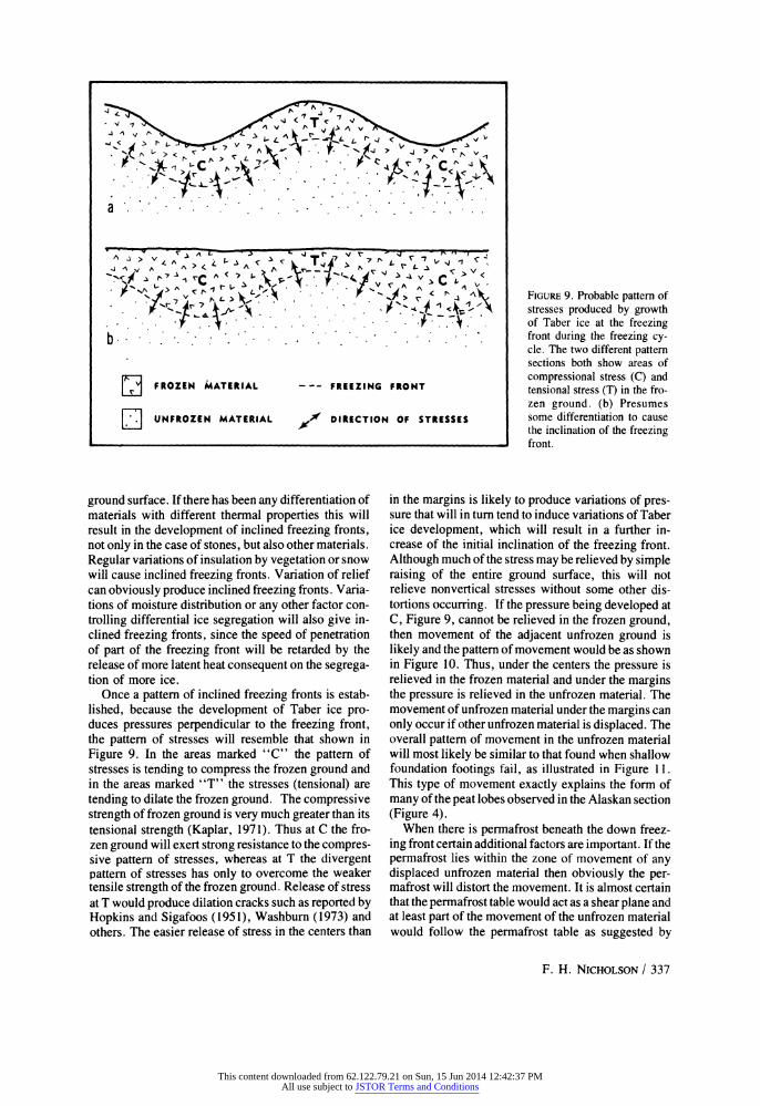
FIGURE 9. Probable pattern of stresses produced by growth of Taber ice at the freezing front during the freezing cy- cle. The two different pattern sections both show areas of compressional stress (C) and tensional stress (T) in the fro- zen ground. (b) Presumes some differentiation to cause the inclination of the freezing front.
ground surface. If there has been any differentiation of materials with different thermal properties this will result in the development of inclined freezing fronts, not only in the case of stones, but also other materials. Regular variations of insulation by vegetation or snow will cause inclined freezing fronts. Variation of relief can obviously produce inclined freezing fronts. Varia- tions of moisture distribution or any other factor con- trolling differential ice segregation will also give in- clined freezing fronts, since the speed of penetration of part of the freezing front will be retarded by the release of more latent heat consequent on the segrega- tion of more ice.
Once a pattern of inclined freezing fronts is estab- lished, because the development of Taber ice pro- duces pressures perpendicular to the freezing front, the pattern of stresses will resemble that shown in Figure 9. In the areas marked "C" the pattern of stresses is tending to compress the frozen ground and in the areas marked "T" the stresses (tensional) are tending to dilate the frozen ground. The compressive strength of frozen ground is very much greater than its tensional strength (Kaplar, 1971). Thus at C the fro- zen ground will exert strong resistance to the compres- sive pattern of stresses, whereas at T the divergent pattern of stresses has only to overcome the weaker tensile strength of the frozen ground. Release of stress at T would produce dilation cracks such as reported by Hopkins and Sigafoos (1951), Washburn (1973) and others. The easier release of stress in the centers than
in the margins is likely to produce variations of pres- sure that will in turn tend to induce variations of Taber ice development, which will result in a further in- crease of the initial inclination of the freezing front. Although much of the stress may be relieved by simple raising of the entire ground surface, this will not relieve nonvertical stresses without some other dis- tortions occurring. If the pressure being developed at C, Figure 9, cannot be relieved in the frozen ground, then movement of the adjacent unfrozen ground is likely and the pattern of movement would be as shown in Figure 10. Thus, under the centers the pressure is relieved in the frozen material and under the margins the pressure is relieved in the unfrozen material. The movement of unfrozen material under the margins can only occur if other unfrozen material is displaced. The overall pattern of movement in the unfrozen material will most likely be similar to that found when shallow foundation footings fail, as illustrated in Figure 11. This type of movement exactly explains the form of many of the peat lobes observed in the Alaskan section (Figure 4).
When there is permafrost beneath the down freez- ing front certain additional factors are important. If the permafrost lies within the zone of movement of any displaced unfrozen material then obviously the per- mafrost will distort the movement. It is almost certain that the permafrost table would act as a shear plane and at least part of the movement of the unfrozen material would follow the permafrost table as suggested by
F. H. NICHOLSON / 337
-
This content downloaded from 62.122.79.21 on Sun, 15 Jun 2014 12:42:37 PMAll use subject to JSTOR Terms and Conditions

E FROZEN MATERIAL --- FREEZING FRONT
1 UNFROZEN MATERIAL I DIRECTION OF STRESSES
4f ACTUAL MOVEMENTS
LOAD
DARK i
DARK SOIL, ORIGINALLY HORIZONTAL
b
Hopkins and Sigafoos (1951). This would explain the form of the peat as seen in Figures 4g and h. If the active layer at the end of the season is deeper under the pattern centers, as shown in Figures 4d, g, and h, then it is likely that the freezing front will reach permafrost under the margins earlier than under the center. Once this has happened all further major pressure developed under the pattern margins must be relieved by dis- placement of the unfrozen material and hence at this stage lateral movements beneath the margins towards
FIGURE 10. Differential movements under critical conditions. The tensional strength of frozen ground is much less than the compres- sional strength. Thus where the frozen ground is under ten- sional stress (T), dilation of the frozen material can be ex- pected, but where the frozen ground is under compres- sional stress (C), movement of the unfrozen material is more likely.
FIGURE 11. (a) An experimen- tal demonstration of typical soil failure under a shallow foundation footing, by use of horizontal colored bands of soil. (After Little, 1961, p. 37). (b) Direction of move- ments indicated by the defor- mation shown in (a).
the centers are likely to be especially effective. Schmertmann and Taylor (1965) have demonstrated that during the freezing of the active layer much segregated ice forms at the permafrost table by loss of heat to the permafrost below. Thus, in suitable condi- tions, an active freezing front progressing upwards must be considered, as well as a freezing front advanc- ing downwards. The amount of upwards freezing will be related to the thermal regime of the permafrost and is likely to be minimal in the Subarctic and most
338 / ARCTIC AND ALPINE RESEARCH
_ _ _~~~~~~~~~~~~~
This content downloaded from 62.122.79.21 on Sun, 15 Jun 2014 12:42:37 PMAll use subject to JSTOR Terms and Conditions
important in the High Arctic. This will complicate the pattern of displacement described above. It is also possible to envisage a form of "basal creep" when there is notable relief on the permafrost table, which would further add to movements from beneath the margins and towards the centers of the patterns. Al- though movements from beneath the margins towards the centers are probably most effective when there is permafrost below, it should not be thought that they only occur under permafrost conditions (Figures 3 and 6).
Movements upward in the pattern center and ra- dially outward from the pattern center at and near the surface have been documented and accepted (espe- cially Chambers, 1967; Washburn 1969, 1973) and thus no attempt will be made here to discuss the movement processes (particularly frost heave, frost creep, needle ice action, and microsolifluction). These movements, and the ones described above, may all be combined in one model as shown in Figure 12. This model shows a circulatory pattern of movements, but probably it is rare for a specific particle to make a full circulation movement. A circulation in patterned ground due to frost thrusting was first suggested by Eakin (1916), though with a simpler mechanism. It should be noted that stones would not move as indi- cated in Figure 12. Stones would be trapped by the freezing front in the pattern margin and therefore would not normally be moved with the unfrozen mate- rial towards the pattern centers. The radial and cir- culatory models should be combined to represent the situation present in many patterns. Figure, 13 shows the combination of the movements shown iin Figures 8 and 12. Stones are shown, as in Figure 8, moving in a radial pattern, except (1) at depth under the centers where the mass displacement due to lateral thrusting is thought to be dominant, and also (2) on the surface of the centers where processes such as needle ice action are moving particles across the ground surface. It is reasoned that in many places the fines will be moving at a slower rate than the stones, because part of the circulatory movement of fines will be in opposition to the tendency of fines to move away from the direction of heat loss, and this is probably a major factor con- tributing to permanent pattern relief.
Modifications of this scheme would cover many cases. Figure 12 shows the situation for stone free material, whereas Figure 8 shows the situation likely if circulatory movements are inhibited (e.g., in very stony material). Undoubtedly in many cases only some parts of the suggested system are at work. If the depth of frost action is very small or if there is only very slight inclination of the freezing fronts then only shallow sorting and lateral displacement by needle ice etc. is probable, or simple vegetation patterns may be formed (controlled by differential heave), all the deeper movements being absent. The evidence of small patterns such as Figure 6 suggests, however,
that circulatory movements may be present in some quite small patterns.
A POSSIBLE MECHANISM OF PATTERN INITIATION There is no doubt that ice wedge polygons are
initiated and developed by a contraction cracking mechanism. Equally there is no doubt that many small equiforms are initiated by dessication or dilation cracks. However the crack hypothesis is less satisfac- tory for many large patterns in the Subarctic and Low Arctic, for several reasons. Thermal contraction cracks will be opened in midwinter and then close in the thaw season, so that early in the following winter, when the main pattern development processes are active, the contraction cracks will not be open. Many subarctic areas are not climatically suited for de- velopment of closely spaced (2-to-7-m) contraction cracks due to either low temperatures or dessication. Additionally the subarctic and low arctic patterns de- scribed above are primarily expansion features and therefore the initiation by contraction requires cooper- ation of two opposed mechanisms. Thus some other initiating mechanism is indicated.
Random frost scars in vegetation, or other isolated frost heaving units, are common and frequently there is an optimum size of heaving unit in any particular area. In the Seward Peninsula there is no doubt that many frost scars correspond to the size of the central areas of patterns. Some areas of contiguous patterns may well have originated by the initiation of a suffi- cient number of frost scars to cover these areas, as suggested by Hopkins and Sigafoos (1951).
On the other hand the alignment and regularity of many patterned-ground areas, especially many sites with elongates and stripes in East Anglia and the Seward Peninsula, suggest a better organization than one that would result from random initiation. Per- fectly aligned elongates or stripes occur covering a whole slope with no discontinuity, and perfect ad- justment to convergent or divergent slopes. In these cases it seems more likely that the first pattern unit to develop is able to "communicate" where the next unit should form. The models described in the previous section suggest a possible mechanism for such "communication" or triggering. When a single ran- dom unit develops, perhaps a frost scar, a slight hum- mock or a stone equiform, it would tend to develop to the optimum size for the area. The development of a center with more than average frost heave appears to cause an adjacent margin of less than average heave. This reduction of heave around the center could be by movement of stones to the margins of the heaving center, by pushing peat to the margins, by inducing differential vegetation growth, by the change in the stress pattern consequent on the development of relief (similar to Figure 9) or perhaps by reducing the mois- ture content of the area around. All of these factors could cause inclined freezing fronts, or some other
F. H. NICHOLSON / 339
This content downloaded from 62.122.79.21 on Sun, 15 Jun 2014 12:42:37 PMAll use subject to JSTOR Terms and Conditions

t 'IT
FIGURE 12. Summary of movements suggesting a circulatory model of patterned-ground development. Probably only fine material can take part in all of the movements, stones especially do not move as shown at F, but remain in the marginal area. Key to Movements A. Material moves upward on freezing, sinks back on thawing, but not to original position because materials have been moved in below. B. Frozen material displaced obliquely outwards on freezing, and sinks back approximately vertically on thawing, giving a net movement outwards. Ca. Action of needle ice, or more general frost creep, producing net movement of materials down the relief of the pattern by a mechanism similar to B. Cb. Microsolifluction in spring producing simple movement down the pattern relief. D. Material near the surface uplifted vertically during the early part of the freezing cycle, falls back vertically by a larger amount on thawing because materials have been removed from below. E. Possibly some uplift on freezing, followed by possibly greater downward movement on thawing due to removal of materials from below. F. Unfrozen material displaced obliquely downward on freezing, no effective recovery on the thawing (cf. Figure 10). G. Unfrozen material displaced by pressure from area around F (cf. Figure 11). No effective recovery. H. Material moved upwards on freezing, sinks back a lesser amount on thawing, similar to A, but net movement often less than at A.
stable margin feature, which would not only encour- age dilation of the original heaving center, but could also encourage greater than average dilation at a simi- lar distance away from the original heaving center. In this way under favorable conditions an original heav- ing center might trigger the production of similar units around it. These new units could then go on to trigger other units until the whole area was covered. This mechanism is suggested by a wide range of qualitative
field observations but proof of such a mechanism needs considerable quantitative data that are not yet available.
The size of the pattern is probably determined by the freezing conditions as indicated by Troll (1944), who described different sizes of patterns characteristic of different environments and freezing conditions. The other likely control of the size of pattern units is the other factor essential for expansion, i.e., the mois-
340 / ARCTIC AND ALPINE RESEARCH
11
- I.. -,, - - -Ae--
11 -
1, ".. .11
.11 1%, , -4--l
This content downloaded from 62.122.79.21 on Sun, 15 Jun 2014 12:42:37 PMAll use subject to JSTOR Terms and Conditions

-~ -j ~- it-0l' c -
POSITIONS OF THE FREEZING FRONT
- STONES < FINE MATERIALS
ture supply, and how this is drawn to a heaving area under the particular environmental conditions. The observations of stripes and elongates following the subsurface drainage rather than the line of maximum
FIGURE 13. Combination model of patterned-ground development showing the dominantly radial movement of stones (cf. Figure 8) and the circulatory movement of finer materials (cf. Figure 12). The movement of fines away from the direction of advance of the freezing front slows the movement of fines in the cen- ters of patterns.
slope, suggest that the mechanics of moisture supply to the heaving centers strongly influence pattern form and perhaps size.
SUMMARY AND CONCLUSIONS
A revised system of patterned-ground description designed for easier field use is proposed: all genetic implications are avoided (Table 1).
Evidence of movements in patterns is presented, especially movements from beneath the margins to beneath the pattern centers. These movements, to- gether with other movements already accepted in the literature, produce an overall circulatory movement of some materials in the pattern, especially the fines. The circulatory movements (Figure 12) are explained in terms of accepted mechanisms, although some ele- ments have not previously been applied to patterned ground (Figures 10 and 11). When a regular pattern of inclined freezing fronts is established, if suitable material is available for sorting, the development of a sorted pattern seems inevitable, following a radial model (Figure 8). As in the case of many other move- ments and differentiations in patterned ground, such a sorting would encourage further pattern development, because it would reinforce the development of in- clined freezing fronts. If the radial model for sorting of fines and stones is combined with the circulation model for movement of fines, the combined model (Figure 13) seems to be able to explain the develop- ment of many forms of patterned ground, whether marked by relief or stone or vegetation.
The initiation of patterns is more problematic than the mechanisms of development. A contraction crack- ing mechanism of initiation and development has been
accepted for ice wedge polygons, and there is no doubt that contraction and dilation cracking initiates some other patterns, especially the smaller sizes. On the other hand the primary movement mechanism of many forms of patterned ground is an expansion mechanism and contraction seems inappropriate as a mechanism of origin for many examples. Some areas of contiguous patterns may originate by simple ran- dom initiation of heaving centers until an entire area is covered. Other contiguous pattern areas are so regular as to suggest a much more organized mechanism. The mechanism tentatively proposed follows from the ob- servation that patterned ground is composed of more heaving centers and less heaving margins. It is pos- tulated that the heave of an initial, isolated center results in the subduing of heaving in the adjacent margins and that, in turn, the area of less heaving will encourage a new center (or centers) of heaving at a unit distance away. The size of patterns is probably controlled by the freezing and moisture supply condi- tions. There are indications that the mechanics of moisture supply to the heaving centers also strongly influences pattern form.
In general, while there is no doubt that compound processes are involved in the development of many types of patterned ground, evidence from the Subarc- tic and Low Arctic suggests that a limited number of combinations of processes may be able to develop the majority of patterned ground types.
ACKNOWLEDGMENTS
This work was funded by the Nature Conservancy of the United Kingdom, the University of Bristol, and
the Gino Watkins Memorial Fund. Most of the work was part of a Ph.D. study supervised at different times
F. H. NICHOLSON / 341
This content downloaded from 62.122.79.21 on Sun, 15 Jun 2014 12:42:37 PMAll use subject to JSTOR Terms and Conditions
by L. F. Curtis, R.M.S. Perrin, and D. Ingle Smith. Special thanks are due to my field assistants, C.J. High in Alaska, and I. Aitken, H. M. Jeffries, D. Rogers, and T. J. Steel in Norway, who not only
REFERENCES Benedict, J. B., 1970: Downslope soil movement in a Col-
orado alpine region: Rates, processes and climatic signifi- cance. Arct. Alp. Res., 2 (3): 165-226.
Beskow, G., 1947: Soil freezing and frost heaving with special application to roads and railroads. Swedish Geol. Soc. Serv. C. No. 375, 1935. (English transl. Osterberg, Northwestern Univ., 1947).
Bliss, L. C., 1963: Alpine plant communities of the Presi- dential Range, New Hampshire. Ecology, 44(4): 678- 697.
Chambers, M. J. G., 1967: Investigations of patterned ground at Signy Island, South Orkney Islands: III Minia- ture patterns, frost heaving and general conclusions. Antarct. Surv. Bull., 12: 1-22.
Corte, A. E., 1963: Vertical migration of particles in front of a moving freezing plane. U.S. Army Cold Regions Res. Engin. Lab. Res. Rep., 105. 8 pp.
, 1966: Particle sorting by repeated freezing and thawing. Biul. Peryglacjal., 15: 175-240.
Eakin, H. M., 1916: The Yukon-Koyukuk Region, Alaska. U.S. Geol. Surv. Bull., 631: 1-88.
Hamelin, L.-E. and Cook, F. A., 1967: Illustrated Glossary of Periglacial Phenomena-Le Periglaciaire par l'image. Presses de l'Universite Laval, Quebec. 237 pp.
Hawkes, L., 1924: Frost action in superficial deposits, Ice- land. Geol. Mag., 61: 509-513.
Hoekstra, P., Chamberlain, E., and Frate, A., 1965: Frost heaving pressures. U.S. Army Cold Regions Res. Engin. Lab. Res. Rep., 176. 12 pp.
Hopkins, D. M. and Sigafoos, R. S., 1951: Frost action and vegetation patterns on Seward Peninsula, Alaska. U.S. Geol. Surv. Bull., 974-C. 100 pp.
Huxley, J. S. and Odell, N. E., 1924: Notes on surface marking in Spitsbergen. Geogr. J., 63: 207-229.
Jahn, A., 1968. Patterned ground. In Fairbridge, R. W. (ed.), The Encyclopedia of Geomorphology. Reinhold, New York. 814-817.
, 1975. Problems of the Periglacial Zone. PWN-Polish Scientific Publishers, Warsaw. 223 pp.
James, P. A., 1972: The periglacial geomorphology of the Rankin Inlet area, Keewatin, N.W.T., Canada. Biul. Peryglacjal. 21: 127-151.
Kaplar, C. W., 1971: Some strength properties of frozen soil and effect of loading rate. U.S. Army Cold Regions Res. Engin. Lab., Spec. Rep., 159. 25 pp.
Little, A. L., 1961: Foundations. Arnold, London. 364 pp. Lundqvist, G., 1949: The orientation of the block material in
certain species of flow earth. Geogr. Ann., 31: 335-347. Nicholson, F. H., 1969: An investigation of patterned
ground. Unpub. Ph.D. Thesis, University of Bristol, Eng- land. 238 pp.
Paterson, T. T., 1940: The effects of frost action and soli- fluxion around Baffin Bay and in the Cambridge District. Quart. J. Geol. Soc., 96: 99-130.
assisted but also paid a major part of their own field expenses. D. M. Hopkins contributed valuable field advice.
Penner, E., 1971: Soil moisture redistribution by ice lensing in freezing soils. Proc. 17th Annual Meeting Canadian Soc. Soil Science, pp. 44-62. (Reprinted Nat. Res. Counc. Can. Div. Building Res. Tech. Pap. 371, 1972.)
Pewe, T. L.; 1966: Ice wedges in Alaska-classification, distribution and climatic significance. Proc. Intern. Per- mafrost Conf., Nat. Acad. Sci., Nat. Res. Counc. Pub. 1287, 76-81.
Philberth, K., 1964: Recherches sur les sols polygonaux et stries. Biul. Peryglacjal, 13: 99-198.
Schmertmann, J. H. and Taylor, R. S., 1965: Quantitative data from a patterned ground site over permafrost. U.S. Army Cold Regions Res. Engin. Lab. Res. Rep., 96. 76 PP.
Sharp, R. P., 1942: Soil structures in the St. Elias Range, Yukon Territory. J. Geomorphol., 5: 274-301.
Taber, S., 1929: Frost heaving. J. Geol., 37: 428-461. , 1930: The mechanics of frost heaving. J.
Geol., 38: 303-317. Troll, C., 1944. Structure soils, solifluction, and frost cli-
mates of the earth. U.S. Army Snow Ice and Permafrost Res. Establishment, Transl., 43. 121 pp.
Washburn, A. L., 1947: Reconnaissance geology of portions of Victoria Island and adjacent regions, Arctic Canada. Geol. Soc. Amer. Mem., 22. 142 pp.
, 1950: Patterned ground. Rev. Can. Geogr., 4(3-4): 5-59.
, 1956: Classification of patterned ground and review of suggested origins. Geol. Soc. Amer. Bull., 67: 823-865.
, 1969: Patterned ground in the Mesters Vig district, Northeast Greenland. Biul. Peryglacjal. 18: 259-330.
, 1973: Periglacial Processes and Environ- ments. Arnold, London. 320 pp.
Watt, A. S., 1955. Stone stripes in Breckland. Geol. Mag., 92: 173-174.
Watt, A. S., Perrin, R. M. S., and West, R. G., 1966: Patterned ground in Breckland: structure and composi- tion. J. Ecol., 54: 239-258.
Williams, R. B. G., 1964: Fossil patterned ground in eastern England. Biul. Peryglacjal. 14: 337-349.
, 1969: Permafrost and temperature conditions in England during the last glacial period. In Troy L. Pewe (ed.), The Periglacial Environment. McGill-Queens Univ. Press, Montreal, 399-410.
Ms submitted April 1976
342 / ARCTIC AND ALPINE RESEARCH
This content downloaded from 62.122.79.21 on Sun, 15 Jun 2014 12:42:37 PMAll use subject to JSTOR Terms and Conditions