Embed Size (px)
Citation preview

Weather Forecasting
Patrick BakNWS Gaylord MI
2019 Michigan Winter Operations Conference
1

What Will We Talk About Today?
• Winter precipitation forecast challenges• New Snow Squall Warning• Finding snow information on NWS Gaylord’s
website
2

Winter Forecast Challenges in the Great Lakes NWS Gaylord
Lake effect snow Great Salt LakeCourtesy of powderchaser

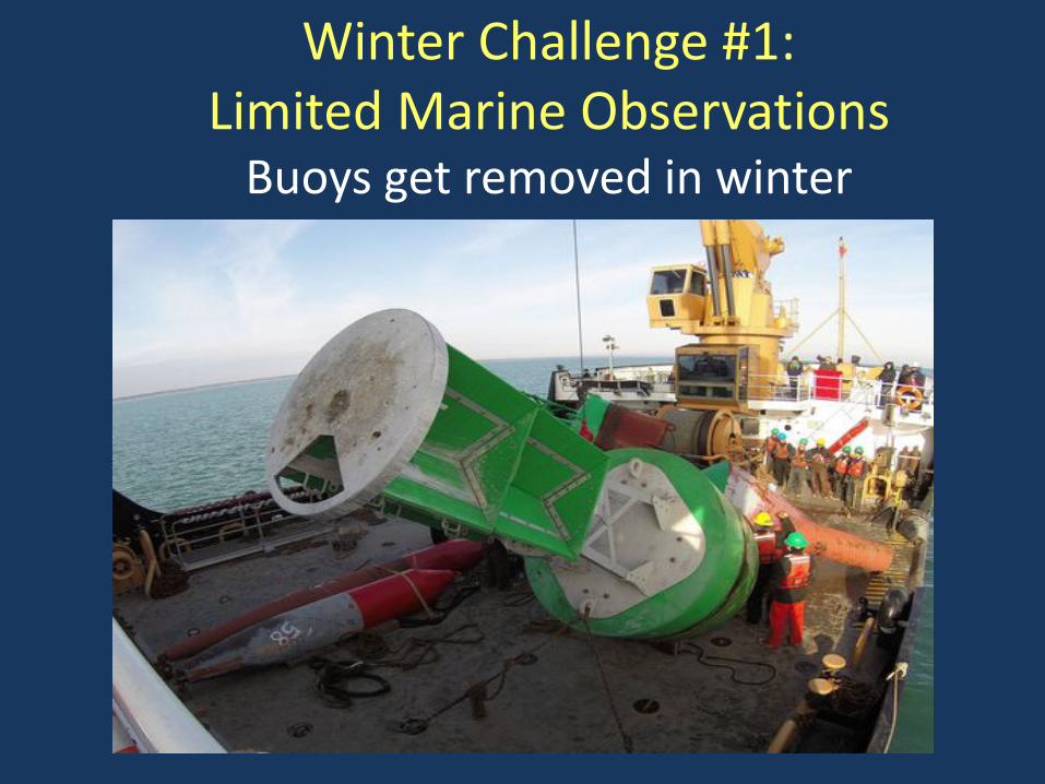
Winter Challenge #1: Limited Marine Observations
Buoys get removed in winter

Winter Challenge #1: Limited Marine Observations
Very few ship observations

Winter Challenge #1: Limited Marine Observations Lots of cloudy days in the winter

Why are cloudy days a problem?
Great Lakes Water Temperatures
Great Lakes Ice Cover Mapping
NOAA Satellite

North-Northwest Flow Northwest Flow
Challenge #2: Slight variations in wind direction have
big impacts on snowfall


North-Northwest Flow Northwest Flow
Snowfall differences withslight differences in wind direction

Challenge #3Great Lakes Ice Cover

Ice cover varies from year to year

March ice cover differences on Lake Superior 2012 versus 2014
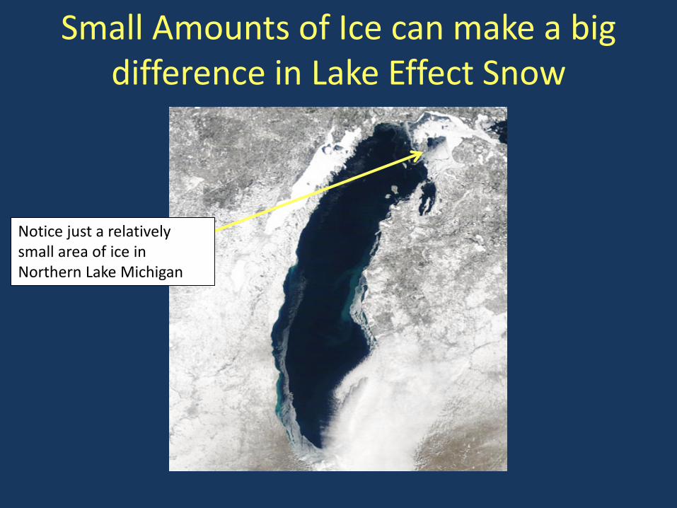
Small Amounts of Ice can make a big difference in Lake Effect Snow
Notice just a relatively small area of ice in Northern Lake Michigan

Northwest winds - No Ice cover

Northwest winds - Ice cover

Challenge #4 Elevation

Seasonally = 8 to 12 inches more snowfall for every 100 foot change in elevation

During winter storms, temperatures generally drop about 1 degree Fahrenheit for every 300-400 foot rise in elevation
Alpena=600 ft MSL
Gaylord=1400 ft MSL

December 20-21, 2012
Heavy Wet Snow in Gaylord Mix of rain and snow
in Alpena

December 20-21, 2012Gaylord Observations Elevation 1400 feet
Alpena Observations Elevation 600 feet

So what happened withregard to snowfall accumulations?

Challenge #5Radar Limitations

Is it snowing here?

Is it snowing in these locations?
Yes

Challenge #6Varying computer model solutions
This is a problem both summer and winter, all across the United States. Differences in computer model
solutions - which have a large impact on the forecast.

Computer Variation in storm tracks from 1 model run (Ensemble Forecasts)

Challenge #6Varying computer model solutions

Why is storm track important? Heaviest snow normally falls 150 to 200 miles
to the left of the surface low track

With all of these challenges…How do meteorologists put the forecast
together?
Computer Models
Pattern Recognition
/ Trends
Observations
Scientific analysis and assessment
Creating a Forecast: Like putting a puzzle together
• Current observations• Various computer
models• Pattern recognition• Forecaster expert
analysis and assessment

Introduction to Snow Squall WarningsWinter 2019-2020

Snow Squall Warnings
What is a Snow Squall?

Snow Squall Warnings
There is a long history of deadly accidents associated with snow squalls.
Snow squalls can cause localized extreme impacts to the traveling public and to commerce for brief periods of time.
The rapid onset of whiteout conditions, combined with gusty winds and falling temperatures can cause extremely dangerous conditions for motorists.
Annual highway fatalities from these events can exceed fatalities from tornadoes and floods combined for portions of the U.S.
Why are we issuing Snow Squall Warnings?

Snow Squall Warnings
Winter-related Motor Vehicle Fatalities Lead Other Hazards

“Short-fused” in nature
Issued for smaller geographic areas for up to 60 minutes
Lead time will generally be 20 to 30 minutes or longer
Issued in a Polygon Format
Similar in format to Severe Thunderstorm Warnings
Quick Facts
Snow Squall Warnings

Snow Squall Warnings
Example of Snow Squall Warning

Warning Text Example

Snow Squall Warnings
SNOW SQUALL WARNING means…
❖ Remain alert to the latest forecast and travel conditions. Consider avoiding or delaying travel until the snow squall passes your location.
❖ Leave extra time if you must travel during snow squalls.
❖ Reduce your speed and turn on headlights!
❖ Don’t slam on brakes!
The Columbus Dispatch The Columbus DispatchRapid white out conditions
and near zero visibility
Expect severe travel difficulties
What to do during a Snow Squall?

Snow Squall Warnings
• NOAA Weather Radio
• Website: http://weather.gov
• Mobile: http://mobile.weather.gov
• iNWS: https://inws.ncep.noaa.gov (Public Safety Officials only)
• NWSChat: https://nwschat.weather.gov
• Other local and state dissemination systems
• State DOT Variable Message Signs (VMS) in some areas
• Future: Cell Phone Wireless Emergency Alerts (WEA)
How do I receive a Snow Squall Warning?

Finding Snow Info On NWS Gaylord Website
42Select “Snow”

Three Days of 12 HourSnowfall Forecast Available
43

Three Days of ExpectedSnow Ratio Data Available
44
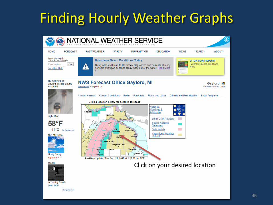
Finding Hourly Weather Graphs
45
Click on your desired location

Finding Hourly Weather Graphs
46
Click on Hourly Weather Forecast

Hourly Weather Graphs
47

Hourly Weather Graphs
48

Questions or want more information?
Pat BakWarning Coordination MeteorologistNWS Gaylord
989-731-3384 Ext 726
[email protected]/gaylord