Embed Size (px)
Citation preview

Pathways in Geospatial Post-Secondary Education and Careers: Education Pathways Project
Amy Ballard and Leland Pierce with contributions by Joseph Zebrowski
New Mexico Geographic Information Council
2015
Forward I am pleased to present the culmination of over three years’ of discussion and work by the leadership of the New Mexico Geographic Information Council (NMGIC). Education has always been an important topic for the NMGIC Board . In 2013, we discussed having a one-day meeting with a session where educators meet with industry leaders to discuss trends, a session where students meet with industry and government leaders, and a session for student posters and presentations: bring together industry, education, and students to discuss geospatial technology in the present and in the future. We referred to it as “Pathways,” as in the pathways people take toward a career in a geospatial field.. While the conference proved to be overly ambitious at this time, it remains a goal, and this document is the first step on our own pathway towards this conference. Amy Ballard, Dr. Joe Zebrowski, and I gathered to discuss how to move “Pathways” forward. We felt a survey identifying what resources for geospatial education are currently locally available as well as identifying current education and industry trends, would be a good start. Within this document are the results of our survey and our analysis of it. We’ve also asked for some professionals to provide a little context on how they see the geospatial landscape of New Mexico. We hope this will be the first of a regular series of reports on geospatial education and industry. We hope to revise it as needed, improving with each update. The document is not intended to be the final word on geospatial education and industry in the state of New Mexico. Our intent is to inform the NMGIC membership about education and industry in their fields. If the document is of benefit outside of NMGIC, all the better. Our hope is the NMGIC membership will find something interesting and useful within this work. Our goal is for this work to inspire people to come together so that we may discuss the Pathways toward great careers in the fields we love. Warmest Regards, Leland J. S. Pierce President, NMGIC Board of Directors Pathways Project Co-Chair

Acknowledgements
This report could not have come to fruition without the cooperation of many of
our colleagues. Joe Zebrowski of New Mexico Highlands University was instrumental
in identifying the programs at New Mexico colleges and universities. Rick Koehler
with the State of New Mexico hosted the survey and compiled the initial results. Our
featured geospatial professionals: Gathen Garcia of PNM, Virginia Seamster of New
Mexico Game and Fish, and Su Zhang of the University of New Mexico generously
offered their time to eloquently respond to our requests for information, which are
featured in this report. Finally, our thanks to the NMGIC Board, who have all been
extremely encouraging of this process.
Introduction The Geospatial industry has been thriving in New Mexico since at least the
early 1990s but has seen major changes over that time. As the demand for employees
with geospatial skills increased along with the variety of different kinds of tasks that
these employees needed to master, training programs evolved to fill the need. This
document presents the result of a survey designed to create a baseline of the current
state of New Mexico’s Geospatial Industry and related education programs. We hope
that this document will be useful for both educators seeking to build relevant
curriculum and anyone seeking basic information about the industry as it currently
stands.
As those of us who have been in the geospatial industry know, there are a
number of factors that make our profession somewhat complicated in terms of

education and training. First, our skills can be applied across an extremely broad
spectrum of industries. From an educational perspective, this means that geospatial
training might occur within an academic program, such as Geography, Urban
Planning, or Anthropology; or it could occur separately as a stand-alone certificate
from a school or other organization. Second, Geospatial does not mean GIS only. The
range of skills encompassed by geospatial includes software-based tasks, but can also
encompass photogrammetry, surveying and other extremely demanding, quantitative
fields. This makes it difficult know what should be included in a program. Finally, we,
as an industry have not settled on a widely-accepted nomenclature for what we teach.
Programs can be variously identified as Geospatial, Geographic Information
Technology, Geomatics, GIScience, etc.
There have been various national level efforts to address geospatial curriculum
in terms of what should be offered by academic programs. The first, known as the
Geospatial Science and Technology (GIST) Body of Knowledge (University Consortium
for Geographic Information Science, 2006) was published in 2006 and sought to
establish model curriculum for Geospatial programs. It included recommended
competencies for Geospatial professionals and detailed curriculum recommendations.
Another, similar effort was undertaken by the GeoTech Center Consortium beginning
around 2008. This NSF-funded Center included faculty from community college
Geospatial programs across the country as Co-PI’s, including from Central New
Mexico Community College in Albuquerque. The results of this effort include model
Geospatial programs and curricula, which can be downloaded and adopted for use by
faculty (see http://www.geotechcenter.org/). The extent to which the Body of
Knowledge and/or GeoTech curricula have been adopted is not clear at this time.
Notably absent from this report is any discussion of K-12 geospatial education. We
hope to address this important topic in future reports.
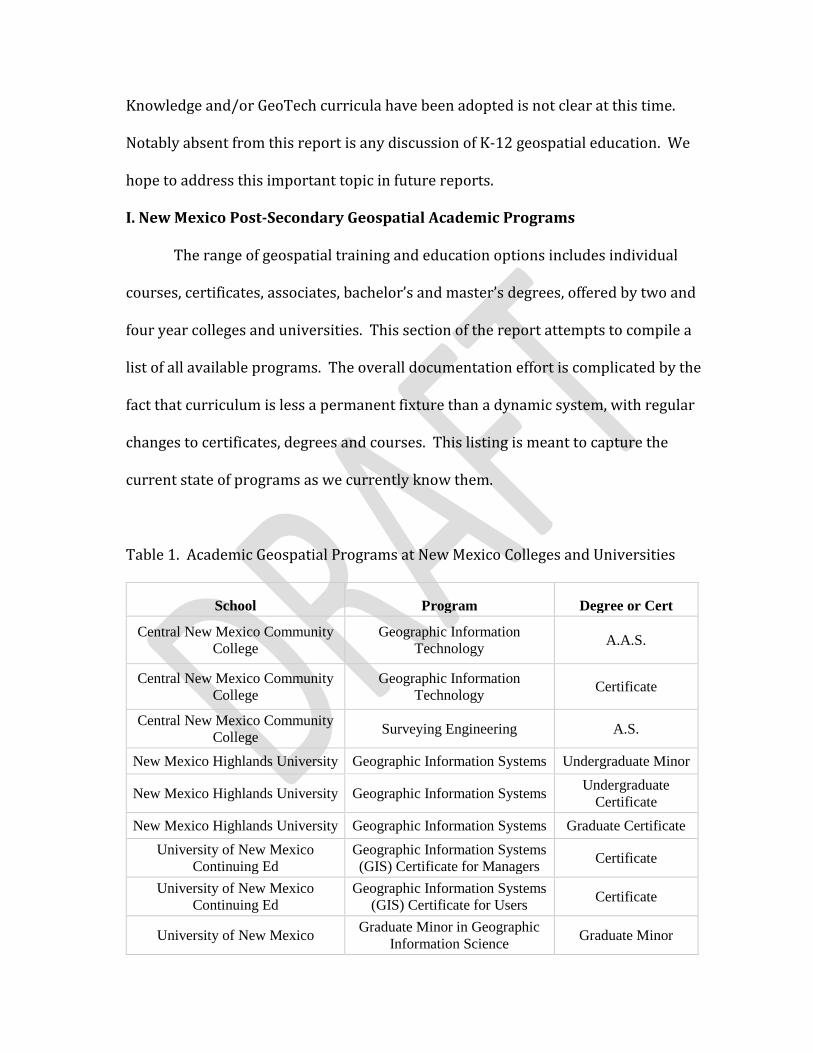
I. New Mexico Post-Secondary Geospatial Academic Programs
The range of geospatial training and education options includes individual
courses, certificates, associates, bachelor’s and master’s degrees, offered by two and
four year colleges and universities. This section of the report attempts to compile a
list of all available programs. The overall documentation effort is complicated by the
fact that curriculum is less a permanent fixture than a dynamic system, with regular
changes to certificates, degrees and courses. This listing is meant to capture the
current state of programs as we currently know them.
Table 1. Academic Geospatial Programs at New Mexico Colleges and Universities
School Program Degree or Cert
Central New Mexico Community
College
Geographic Information
Technology A.A.S.
Central New Mexico Community
College
Geographic Information
Technology Certificate
Central New Mexico Community
College Surveying Engineering A.S.
New Mexico Highlands University Geographic Information Systems Undergraduate Minor
New Mexico Highlands University Geographic Information Systems Undergraduate
Certificate
New Mexico Highlands University Geographic Information Systems Graduate Certificate
University of New Mexico
Continuing Ed
Geographic Information Systems
(GIS) Certificate for Managers Certificate
University of New Mexico
Continuing Ed
Geographic Information Systems
(GIS) Certificate for Users Certificate
University of New Mexico Graduate Minor in Geographic
Information Science Graduate Minor
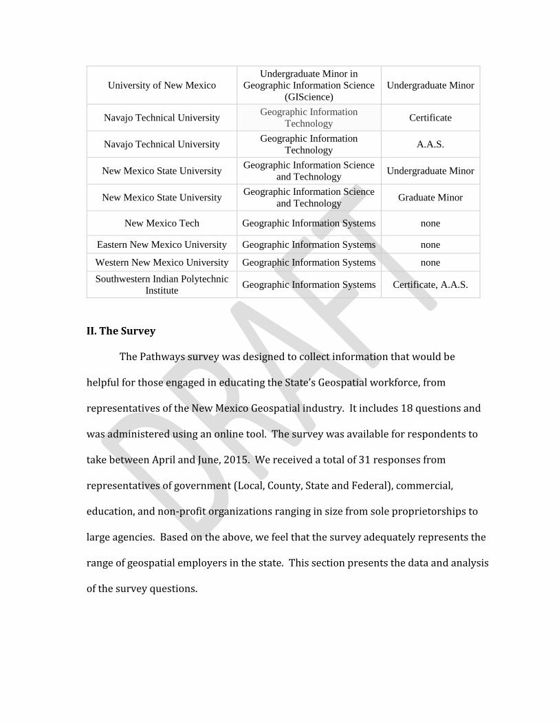
University of New Mexico
Undergraduate Minor in
Geographic Information Science
(GIScience)
Undergraduate Minor
Navajo Technical University Geographic Information
Technology Certificate
Navajo Technical University Geographic Information
Technology A.A.S.
New Mexico State University Geographic Information Science
and Technology Undergraduate Minor
New Mexico State University Geographic Information Science
and Technology Graduate Minor
New Mexico Tech Geographic Information Systems none
Eastern New Mexico University Geographic Information Systems none
Western New Mexico University Geographic Information Systems none
Southwestern Indian Polytechnic
Institute Geographic Information Systems Certificate, A.A.S.
II. The Survey
The Pathways survey was designed to collect information that would be
helpful for those engaged in educating the State’s Geospatial workforce, from
representatives of the New Mexico Geospatial industry. It includes 18 questions and
was administered using an online tool. The survey was available for respondents to
take between April and June, 2015. We received a total of 31 responses from
representatives of government (Local, County, State and Federal), commercial,
education, and non-profit organizations ranging in size from sole proprietorships to
large agencies. Based on the above, we feel that the survey adequately represents the
range of geospatial employers in the state. This section presents the data and analysis
of the survey questions.

Characteristics of Survey Respondents
The Albuquerque/Rio Rancho area provided the most responses with 16, Santa
Fe next with 9. Responses were also received from Aztec, Belen, Clovis, Las Vegas and
Los Alamos. Some respondents had offices outside of New Mexico, such as Rockville,
MD, San Francisco, CA, and Tampa, FL. The map below provides a graphic display of
the information collected.
Figure 1. Map showing geographic distribution of respondents
Respondents were asked to specify whether their organization is best
described as a government, commercial, education or non-profit entity. Results,
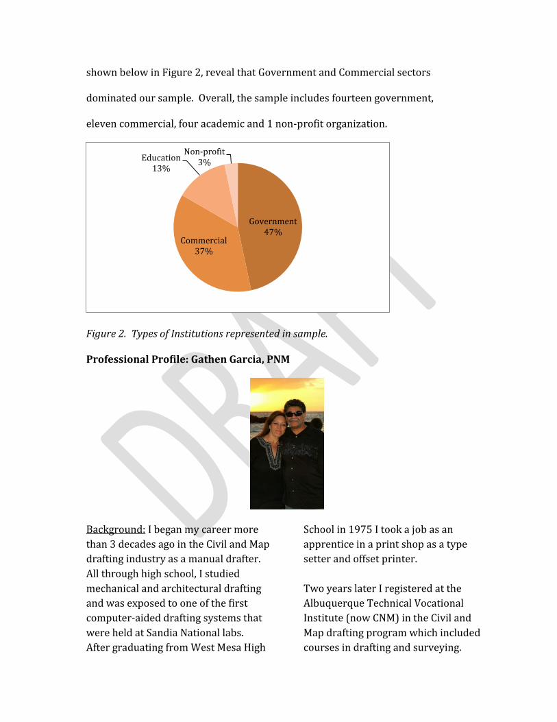
shown below in Figure 2, reveal that Government and Commercial sectors
dominated our sample. Overall, the sample includes fourteen government,
eleven commercial, four academic and 1 non-profit organization.
Figure 2. Types of Institutions represented in sample.
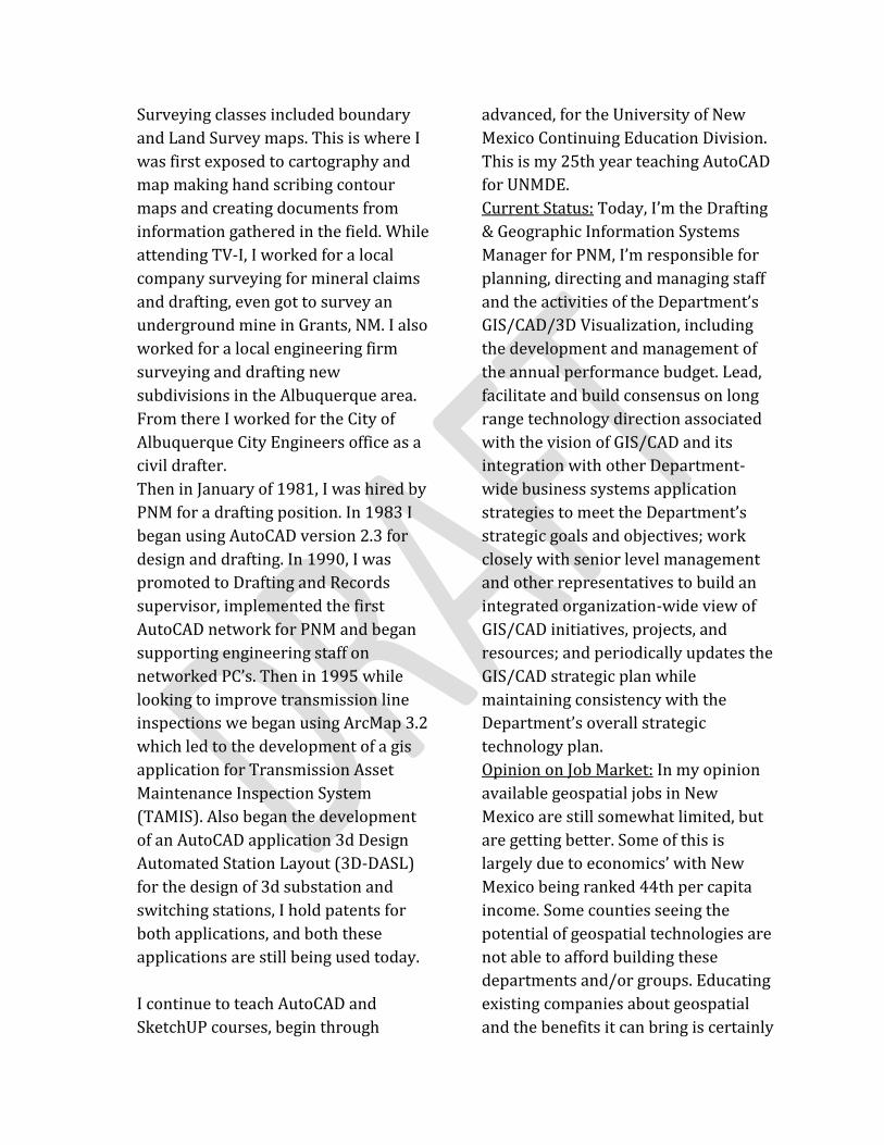
Professional Profile: Gathen Garcia, PNM
Background: I began my career more
than 3 decades ago in the Civil and Map
drafting industry as a manual drafter.
All through high school, I studied
mechanical and architectural drafting
and was exposed to one of the first
computer-aided drafting systems that
were held at Sandia National labs.
After graduating from West Mesa High
School in 1975 I took a job as an
apprentice in a print shop as a type
setter and offset printer.
Two years later I registered at the
Albuquerque Technical Vocational
Institute (now CNM) in the Civil and
Map drafting program which included
courses in drafting and surveying.
Government47%
Commercial37%
Education13%
Non-profit3%
Surveying classes included boundary
and Land Survey maps. This is where I
was first exposed to cartography and
map making hand scribing contour
maps and creating documents from
information gathered in the field. While
attending TV-I, I worked for a local
company surveying for mineral claims
and drafting, even got to survey an
underground mine in Grants, NM. I also
worked for a local engineering firm
surveying and drafting new
subdivisions in the Albuquerque area.
From there I worked for the City of
Albuquerque City Engineers office as a
civil drafter.
Then in January of 1981, I was hired by
PNM for a drafting position. In 1983 I
began using AutoCAD version 2.3 for
design and drafting. In 1990, I was
promoted to Drafting and Records
supervisor, implemented the first
AutoCAD network for PNM and began
supporting engineering staff on
networked PC’s. Then in 1995 while
looking to improve transmission line
inspections we began using ArcMap 3.2
which led to the development of a gis
application for Transmission Asset
Maintenance Inspection System
(TAMIS). Also began the development
of an AutoCAD application 3d Design
Automated Station Layout (3D-DASL)
for the design of 3d substation and
switching stations, I hold patents for
both applications, and both these
applications are still being used today.
I continue to teach AutoCAD and
SketchUP courses, begin through
advanced, for the University of New
Mexico Continuing Education Division.
This is my 25th year teaching AutoCAD
for UNMDE.
Current Status: Today, I’m the Drafting
& Geographic Information Systems
Manager for PNM, I’m responsible for
planning, directing and managing staff
and the activities of the Department’s
GIS/CAD/3D Visualization, including
the development and management of
the annual performance budget. Lead,
facilitate and build consensus on long
range technology direction associated
with the vision of GIS/CAD and its
integration with other Department-
wide business systems application
strategies to meet the Department’s
strategic goals and objectives; work
closely with senior level management
and other representatives to build an
integrated organization-wide view of
GIS/CAD initiatives, projects, and
resources; and periodically updates the
GIS/CAD strategic plan while
maintaining consistency with the
Department’s overall strategic
technology plan.
Opinion on Job Market: In my opinion
available geospatial jobs in New
Mexico are still somewhat limited, but
are getting better. Some of this is
largely due to economics’ with New
Mexico being ranked 44th per capita
income. Some counties seeing the
potential of geospatial technologies are
not able to afford building these
departments and/or groups. Educating
existing companies about geospatial
and the benefits it can bring is certainly
a good start. Private sector working
with state and county agencies to help
develop/sharing geospatial expertise
with their gis groups. Become involved
with NMGIC and GAC.
Opinion on Training: My opinion on
available training in New Mexico in the
various geospatial professions is
limited to ……not having shareable data
available from the private sector for
students to work with. In the electric
industry for example some data sets
are not shared for security and
proprietary reason. However with
planning between the training
institutions and the private sector
these barriers could be overcome. The
training being held is at a high level
and does not prepare students for
advancement careers in the industry.
Students need to be exposed how GIS is
used in an enterprise and not just
within a given department.
An enterprise GIS improves
organization workflows since it applies
a geographic approach to relate legacy
and new information for better
decision making; greater efficiency
with money, time, and resources; and
more effective communication across
the corporation. GIS integrates
hardware, software, and data for
managing, capturing, and displaying all
forms of geographically referenced
information.
The enterprise GIS framework has the
following characteristics; Scalable,
extensible, reliable, and secure, open,
interoperable, and standards based,
capable of being effectively integrated
within the enterprise. May be complex
to implement; requires significant
planning and support; delivers a high
return on investment.
Advice for Students: My advice to
students is to never stop learning how
geospatial data can be used. Push the
boundaries of gis usage today.
Data management - Enterprise GIS data
management focuses on the efficient
storage and retrieval of all the
organization's relevant geographic
information.
Visualization - The visualization of
information in a geographic context
provides an intuitive means for
accurate and rapid decision making.
Visualization is the most obvious
demonstration of enterprise GIS.
Enterprise GIS will also exploit
visualization capabilities by
incorporating them into tasks and
activities not traditionally associated
with GIS.
Spatial analysis - The wealth of
geographic information in our
organization is the goal of spatial
analysis for the enterprise. It is this
capability that nontraditional users of
GIS will most greatly benefit from.
Always ask the question what if?
Advice for Teachers: The advice I
would give teachers and instructors is
to providing a good foundation of
current GIS efforts which are diverse
and include: creation of map products,
spatial analyses, database queries,
records management, and ad hoc
information retrieval.
Be willing to share your practical
experiences with the GIS technology
and profession. Listen to your student’s
questions as they can provide insight
to problems we have yet to figure out.
Sometimes the student is the teacher
and provides us an opportunity to step-
outside our own comfort zone. At the
beginning of any new class, let students
know there may be some questions you
cannot answer, but will work to find an
answer/ solution to their question.
It’s ok to step outside the class
syllabus, this is only a guide for the
class, both student and teacher benefit
from doing this.
Advice for Employers: An Enterprise
GIS Organization needs to provide
direction using a common
infrastructure for building and
deploying GIS solutions; Extending
geospatial capabilities to an enterprise
community, improving capabilities of
other enterprise systems by leveraging
the value of geographic information.
Focus on organization-wide business
needs strategic goals and long-term
focus. To develop, manage and
distribute authoritative GIS
information critical to supporting
reliable service to your customers.
III. The Nature of Geospatial Work in New Mexico
The survey included questions requesting respondents to reflect on the nature
of the geospatial work that their organization performs, both by primary field of
interest, broad activity category and specific task. The information on tasks is
invaluable for geospatial educators. While not as in-depth as a formal DACUM
(Developing a Curriculum) process, the insights that can be gained from our sample
may lead geospatial educators to reflect on their curriculum in light of industry needs.
The array of industry sectors represented in the sample is shown in Figure 3.,
showing a preponderance of Natural Resource related employers. Delving into the
specific work being performed, the survey asked respondents to pick from the list of
task categories, choosing all that they engaged in. Figure 4. shows the results of this
question, showing 87% of employers engaged in data collection of some sort.

Figure 3. Industries Represented in the Sample
Figure 4. Categories of Geospatial Work Being Performed
0 10 20 30 40 50
Emergency/Security
Commercial
Education and Research
Policy and Implementation
Natural Resource Management
0%
3%
3%
23%
26%
26%
29%
29%
45%
48%
61%
65%
71%
87%
Software and Equipment Sales
Data integration and statistical…
Spatial data aggregation,…
Surveying
Research and Development
Photogrammetry
Training
Remote Sensing
Application…
Web-based Mapping
Data Visualization
Database Management
Analysis
Data Collection
The survey also collected data on more specific types of tasks being carried out by
New Mexico’s geospatial workforce. Respondents were asked to rank tasks in order
frequency with which they were performed. Twelve specific tasks were identified, and
respondents were also given the option of an open-ended response to describe other tasks.
Only 5 respondents entered a task in the “other” category, suggesting that the tasks
presented by the survey accurately reflected the nature of geospatial work in New Mexico.
The tasks include head’s up digitizing, downloading data from the Internet, building
databases, creating applications for clients, creating visualizations for clients, creating
hardcopy maps, field-based data collection, analyzing multi-spectral imagery, analyzing
digital imagery, performing geospatial analysis, providing training, and presenting the
results of geospatial analysis. “Other” tasks included data integration and statistical
analysis; converting older legacy data and formats; data aggregation, integration and
standardization; creating instructional materials; and customer support for hardware or
software.
Respondents were asked to rank these tasks from 1-12 in terms of frequency
with which they are performed, with 1 being most frequent and 12 least frequent.
Therefore, each respondent would rank every task. While not straightforward to interpret,
one way to think about this question is to examine which tasks were most frequently
identified as more common (receiving a lower number in the ranks). To do this, first a
mean value was generated for each task. Tasks with a lower mean value were ranked as
more frequent that those with a higher mean. The results are presented in the Table 2.

Table 2. Task Frequency Ratings
Task Mean Value
Number of Times
Task rated 1, 2 or 3
Building Geodatabases or other GIS databases
4.41 13
Creating hardcopy maps 4.97 12 Creating digital visualizations for clients
5.28 10
Performing geospatial analysis
5.28 12
Field-based data collection
5.31 14
Downloading and processing data from the Internet
6.03 8
Creating applications for clients
6.97 9
Presenting results of geospatial analysis
7.03 6
Providing training for clients
7.97 5
Analyzing digital imagery
8.21 1
Analyzing multispectral imagery
10.03 0
Clearly, developing Geodatabases and other databases is a crucial skill for our
geospatial students. Somewhat surprisingly, the creation of hardcopy maps also ranks very
high. Though having a lower mean than some other tasks, more respondents indicated that
field-based data collection is their primary task than any other task in the survey.
IV. Getting the Work Done: Software, Hardware and Equipment

In addition to the specific tasks performed by geospatial employees, information about the
tools used to complete this work are crucial for geospatial educators to understand, in
order to make informed decisions about purchases. Hardware, software and equipment
costs are second only to faculty salaries in terms of overall programs costs, so aligning
industry and education in this area is extremely important. Though many geospatial and
other skills translate to the workplace regardless of specific brands, in many cases students
can gain an advantage by already having knowledge of common industry tools.
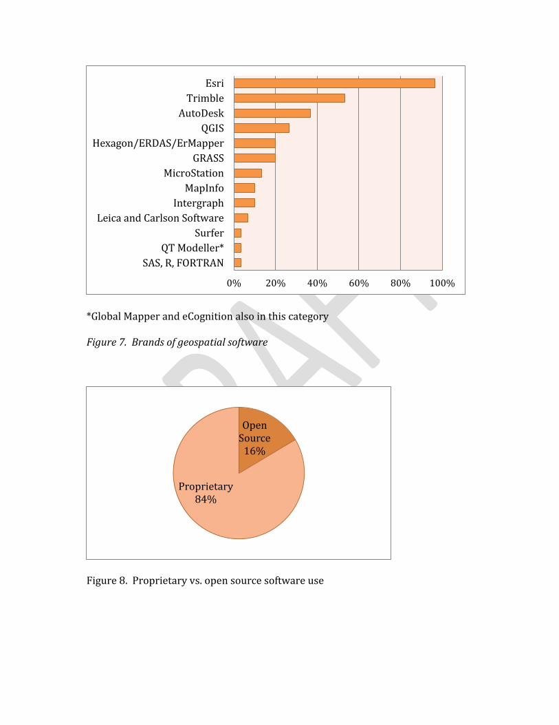
In terms of broad categories of software used to perform geospatial work, desktop GIS
still dominates the landscape (Figure 6.). Web-based GIS is a close second. As far as
specific manufacturers go, Esri tops the list (Figure 7.). As Figure 8 shows, proprietary
software is widely used by survey respondents, with only 16% of claiming use of open
source software at this time.
Figure 6. Types of software used to support geospatial projects
0% 20% 40% 60% 80% 100%
Scanning and Robotic
Data Visualization
Remote Sensing
Photogrammetric
Organization-specific GIS
CAD
Open Source or Free GIS
Mobile GIS
Server-based GIS
GPS-specific
Web-based GIS
Desktop GIS
*Global Mapper and eCognition also in this category
Figure 7. Brands of geospatial software
Figure 8. Proprietary vs. open source software use
0% 20% 40% 60% 80% 100%
SAS, R, FORTRAN
QT Modeller*
Surfer
Leica and Carlson Software
Intergraph
MapInfo
MicroStation
GRASS
Hexagon/ERDAS/ErMapper
QGIS
AutoDesk
Trimble
Esri
Open Source
16%
Proprietary84%
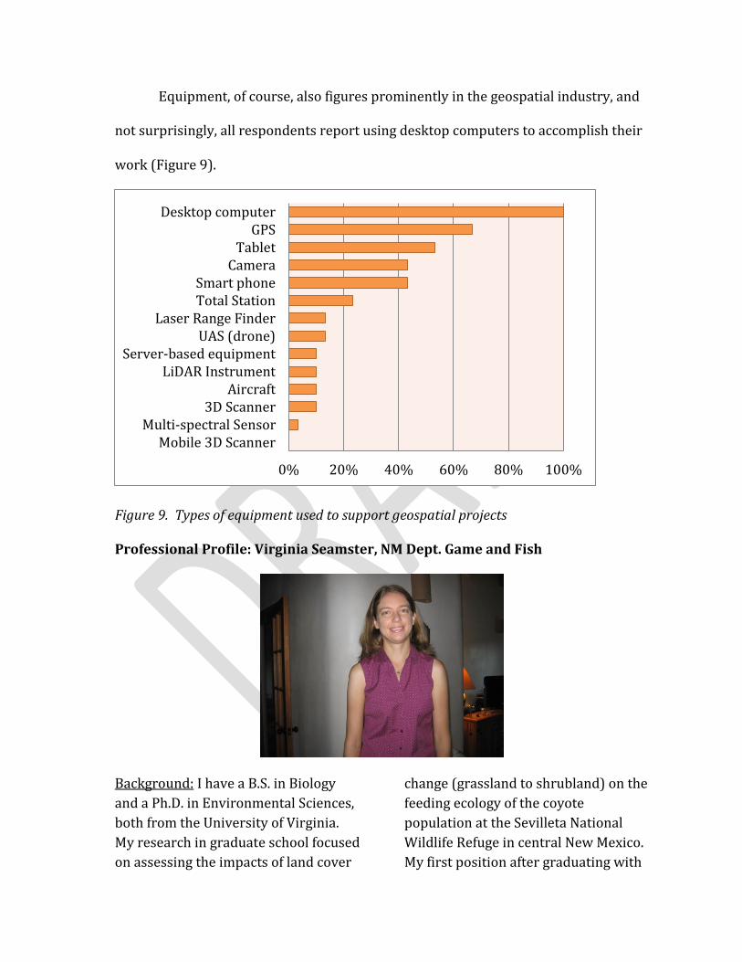
Equipment, of course, also figures prominently in the geospatial industry, and
not surprisingly, all respondents report using desktop computers to accomplish their
work (Figure 9).
Figure 9. Types of equipment used to support geospatial projects
Professional Profile: Virginia Seamster, NM Dept. Game and Fish
Background: I have a B.S. in Biology
and a Ph.D. in Environmental Sciences,
both from the University of Virginia.
My research in graduate school focused
on assessing the impacts of land cover
change (grassland to shrubland) on the
feeding ecology of the coyote
population at the Sevilleta National
Wildlife Refuge in central New Mexico.
My first position after graduating with
0% 20% 40% 60% 80% 100%
Mobile 3D ScannerMulti-spectral Sensor
3D ScannerAircraft
LiDAR InstrumentServer-based equipment
UAS (drone)Laser Range Finder
Total StationSmart phone
CameraTablet
GPSDesktop computer

my Ph.D. was working as a GIS Analyst
with The Trust for Public Land (TPL). I
then obtained a position as a post
doctoral researcher at New Mexico
State University (NMSU) and worked at
NMSU for just over 3 years. I was
recently hired by New Mexico
Department of Game and Fish
(NMDGF) as their BISON-M/Share with
Wildlife Coordinator in the Ecological
and Environmental Planning Division. I
have used geospatial technologies
since the fourth year of my
undergraduate studies. I took a GIS
course that year and applied GIS
software for the research project I
completed for my undergraduate
honor’s thesis. I continued using GIS
software to make maps and conduct
spatial analyses, including
development of a land cover map, for
my graduate research. I learned a great
deal more about cartography during
my 7 month tenure with TPL. For my
research position with NMSU I
extended my GIS skills by developing a
web-based map intended to facilitate
searching for and obtaining documents
generated by or for NMDGF using both
text and spatial queries. I also used
spatial data and GIS software in a
project intended to assess the effect of
climate change on the distribution of
suitable environmental conditions for
20 terrestrial vertebrate species found
in New Mexico, Oklahoma, and Texas.
Current Status: I am new to my current
profession but my job entails two
primary tasks: database management
and contract management for research
and other projects related to non-game
species of wildlife found in New
Mexico. More specifically, I will be
working to keep information regarding
the biology and ecology of several
thousand species found in New Mexico
up to date. These data are stored in a
web-enabled SQL Server database.
Prior to setting up contracts, I will be
responsible for organizing a grant
proposal review panel and facilitating
the process of selecting which
proposed projects receive funding
through the Share with Wildlife
program. There is potential for
application of geospatial technology in
the process of creating a database of all
previously funded Share with Wildlife
projects and their locations. There is
interest in linking the web-enabled
database (the Biota Information
System of New Mexico or BISON-M)
with other websites that involve web-
based maps. BISON-M also provides
access to web-based maps of the
geographic distributions of many New
Mexican species.
Opinion on Job Market: There appear
to be geospatial jobs available with
both non-profits and government
agencies at multiple levels (city,
county, state) in New Mexico. There are
fewer positions in academia. The
government jobs seem to require
higher levels of basic IT skills,
including software and network
management capability, than the non-
profit positions. However, the GIS
departments in most New Mexico
agencies and non-profits are fairly
small. Thus broader experience and
knowledge of a diversity of aspects of
both the infrastructure and application
of GIS technology is beneficial.
Opinion on Training: I am not very
familiar with training available in New
Mexico regarding the various
geospatial professions. The only GIS
training I have received while in New
Mexico was on the job training from
colleagues. Other information I
gathered from on-line forums,
assistance from ESRI technical support,
and trial and error. My understanding
is that, in addition to courses provided
on campus through the various
universities (New Mexico State
University, University of New Mexico,
and New Mexico Highlands University),
New Mexico State University provides
some courses through their NM EDGE
program. There are also on-line
courses available. I only took three
courses related to either GIS or remote
sensing when I was a student and the
University of Virginia did not have a
geography department or any kind of
emphasis on GIS training. Thus, I would
consider the training available in New
Mexico to be much more diverse and
allow students to gain a more formal
training in GIS than anything I was
exposed to or aware of during my
academic career.
Advice for Students: Depending on the
sort of entity you want to work for, I
would recommend learning at least
one programming language, possibly
multiple, and learning about computer
networking. Knowledge of web-based
mapping is valuable, if not crucial,
given the direction that GIS is heading.
I didn’t really learn anything about
web-based mapping in school and I
would have benefited greatly from
some prior exposure to the basic
concepts, terminology, and
functionality of web-based maps.
Programming skills are useful for
almost any GIS application but
especially handy if there is an interest
in pursuing positions that entail
developing web-based maps or mobile
phone applications. Mobile phone
applications are definitely the wave of
the future and so understanding the
differences between designing maps
for desktop vs. mobile users is
valuable. I’d also recommend gaining
as much knowledge as possible
regarding database structure, design,
and metadata. Knowledge of how to
use at least one database software,
including SQL Server or MS Access, is
helpful as is knowledge of programs
that can be used in processing spatial
datasets, such as R or Matlab. In
general I find that people who have the
technical skills are more valued than
those who know more on the
application end. But again, it depends
on what kind of position you are going
for; if you want to manage a GIS
program or go heavily into web-based
application design or data analysis,
you’ll need more technical skills than if
you are interested in being a
cartographer or applying GIS to
environmental compliance or wildlife
issues. Different fields also seem to
have different platforms that they
prefer; climatologists don’t seem to use
ArcGIS software at all, they use netCDF
files and linux systems while ecologists
are more likely to use windows and
run R and ArcGIS.
Advice for Teachers: I would
recommend having students do as
many projects, labs and other activities
that involve using GIS and related
software (e.g., SQL Server; R) as
possible. It is important to acquire a
basic understanding of the different
data types and become familiar with
relevant terminology. But there is
really no substitute for using the
software and learning by doing, and
even more importantly, learning by
making mistakes and asking questions
of your instructor and your peers.
There is rarely a single correct way of
performing a geospatial analysis; there
are often multiple pathways to the
same product. Students learn more
about the tools that are available, their
functionality, and potential problems
that they can run into by trial and error
than they ever could listening to
presentations in a classroom.
Advice for Employers: The ability to
interact with other GIS professionals,
and possibly more importantly, IT
professionals is something that I’ve
found to be very helpful in my career.
There were several aspects of projects
I’ve worked on that would not have
been possible or would have been done
very differently if I hadn’t had access to
individuals with good programming
and other IT skills. If it’s possible to
have more than one GIS person, or to
allow for or even encourage interaction
between your GIS and IT departments,
that should smooth the way for your
GIS professionals and enable them to
accomplish more than they otherwise
could. The ability to attend local
meetings (such as those hosted by
NMGIC and the NM GAC) as well as
national conferences (such as the ESRI
user conference) is also crucial in
staying up to date. Geospatial
technology evolves rapidly and it is
important to be able to stay on top of
the latest developments. Interactions
with peers greatly facilitate this.
V. Education for the Geospatial Workforce
While education and training are important, the ability for students to find
employment in the geospatial field after graduating from an academic program is the
bottom line for many educational institutions in the State. Many of the survey
questions were designed to characterize New Mexico’s geospatial workforce in terms
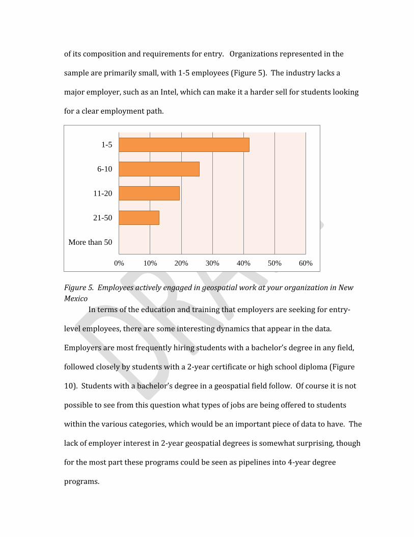
of its composition and requirements for entry. Organizations represented in the
sample are primarily small, with 1-5 employees (Figure 5). The industry lacks a
major employer, such as an Intel, which can make it a harder sell for students looking
for a clear employment path.
Figure 5. Employees actively engaged in geospatial work at your organization in New
Mexico
In terms of the education and training that employers are seeking for entry-
level employees, there are some interesting dynamics that appear in the data.
Employers are most frequently hiring students with a bachelor’s degree in any field,
followed closely by students with a 2-year certificate or high school diploma (Figure
10). Students with a bachelor’s degree in a geospatial field follow. Of course it is not
possible to see from this question what types of jobs are being offered to students
within the various categories, which would be an important piece of data to have. The
lack of employer interest in 2-year geospatial degrees is somewhat surprising, though
for the most part these programs could be seen as pipelines into 4-year degree
programs.
0% 10% 20% 30% 40% 50% 60%
More than 50
21-50
11-20
6-10
1-5
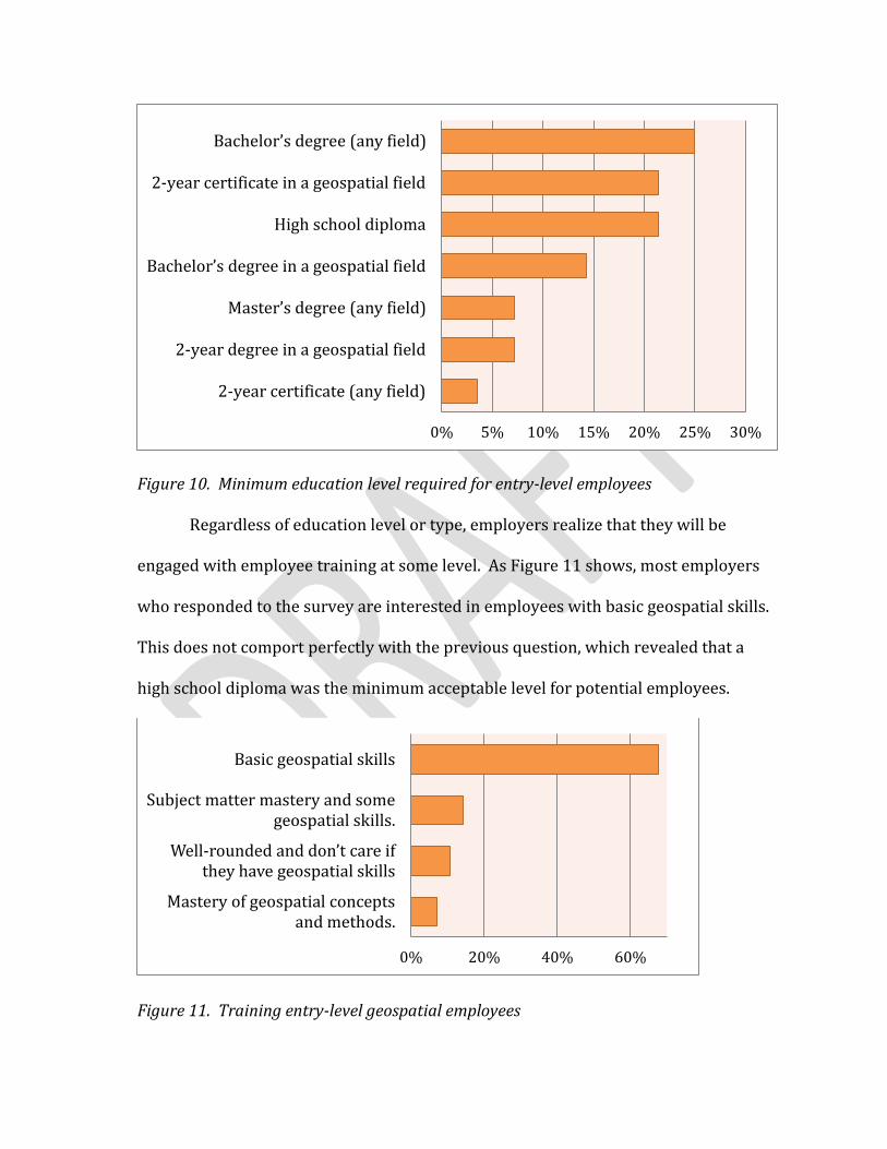
Figure 10. Minimum education level required for entry-level employees
Regardless of education level or type, employers realize that they will be
engaged with employee training at some level. As Figure 11 shows, most employers
who responded to the survey are interested in employees with basic geospatial skills.
This does not comport perfectly with the previous question, which revealed that a
high school diploma was the minimum acceptable level for potential employees.
Figure 11. Training entry-level geospatial employees
0% 5% 10% 15% 20% 25% 30%
2-year certificate (any field)
2-year degree in a geospatial field
Master’s degree (any field)
Bachelor’s degree in a geospatial field
High school diploma
2-year certificate in a geospatial field
Bachelor’s degree (any field)
0% 20% 40% 60%
Mastery of geospatial conceptsand methods.
Well-rounded and don’t care if they have geospatial skills
Subject matter mastery and somegeospatial skills.
Basic geospatial skills

Figure 12. Desirable skills for entry-level geospatial employees
It is clear that employers are looking for employees with basic geospatial skills,
but what other specific skills do they value? By a wide margin, employers surveyed
responded that soft skills such as ability to work with a team, showing up on time, etc.
were very important in potential employees. Working with educators to make sure
that these skills are being taught would be an important are for future work. The only
other skills identified as very important were geometry and statistical analysis.
When seeking geospatial employees, employers use a number of different
approaches (Figure 12). The Internet and other media outlets dominate the survey
responses. Since many of the respondents are government entities, the use of
government hiring processes figures prominently. A trend also suggested by the
responses is the retraining of existing employees to do geospatial work.
Quantitative Math/Calculus
SQL/Database Development
Coding/Scripting
Statistical Analysis
Geometry
Soft Skills (like team work)
Not Important Somewhat Important
Important Very Important
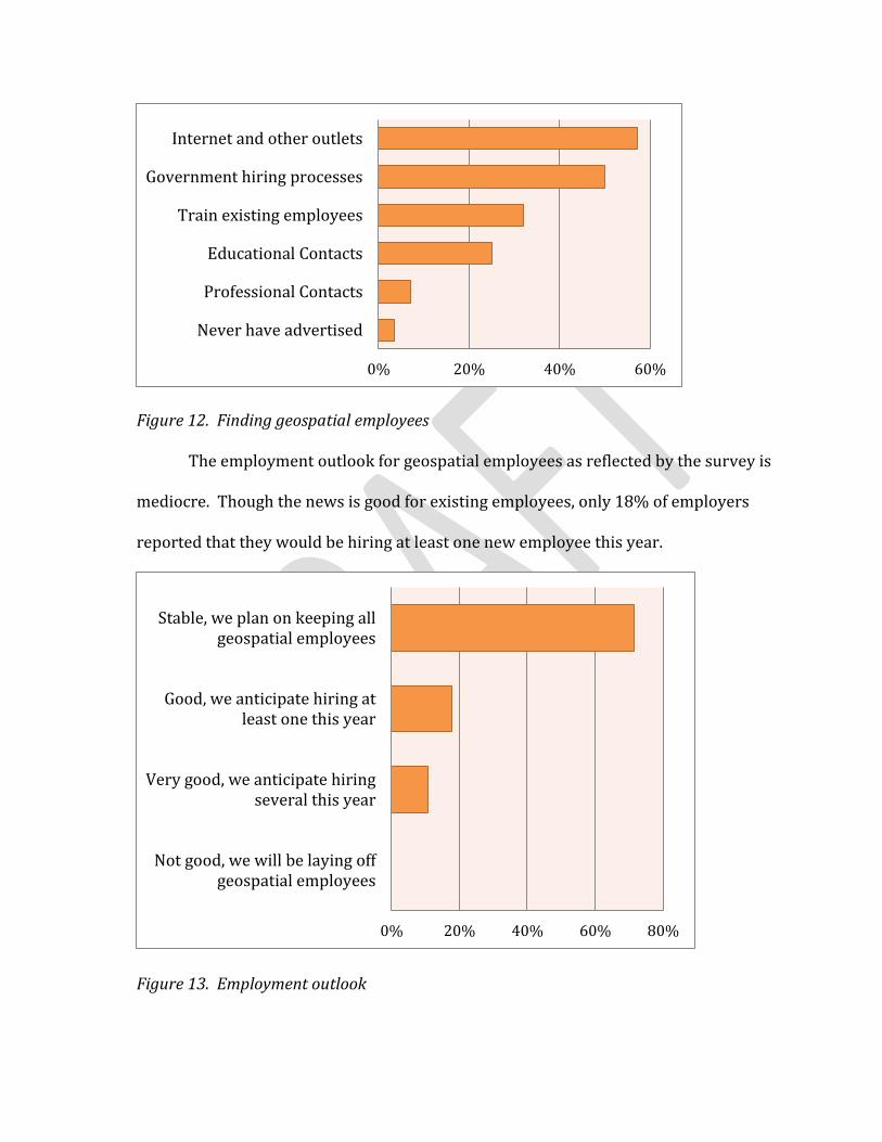
Figure 12. Finding geospatial employees
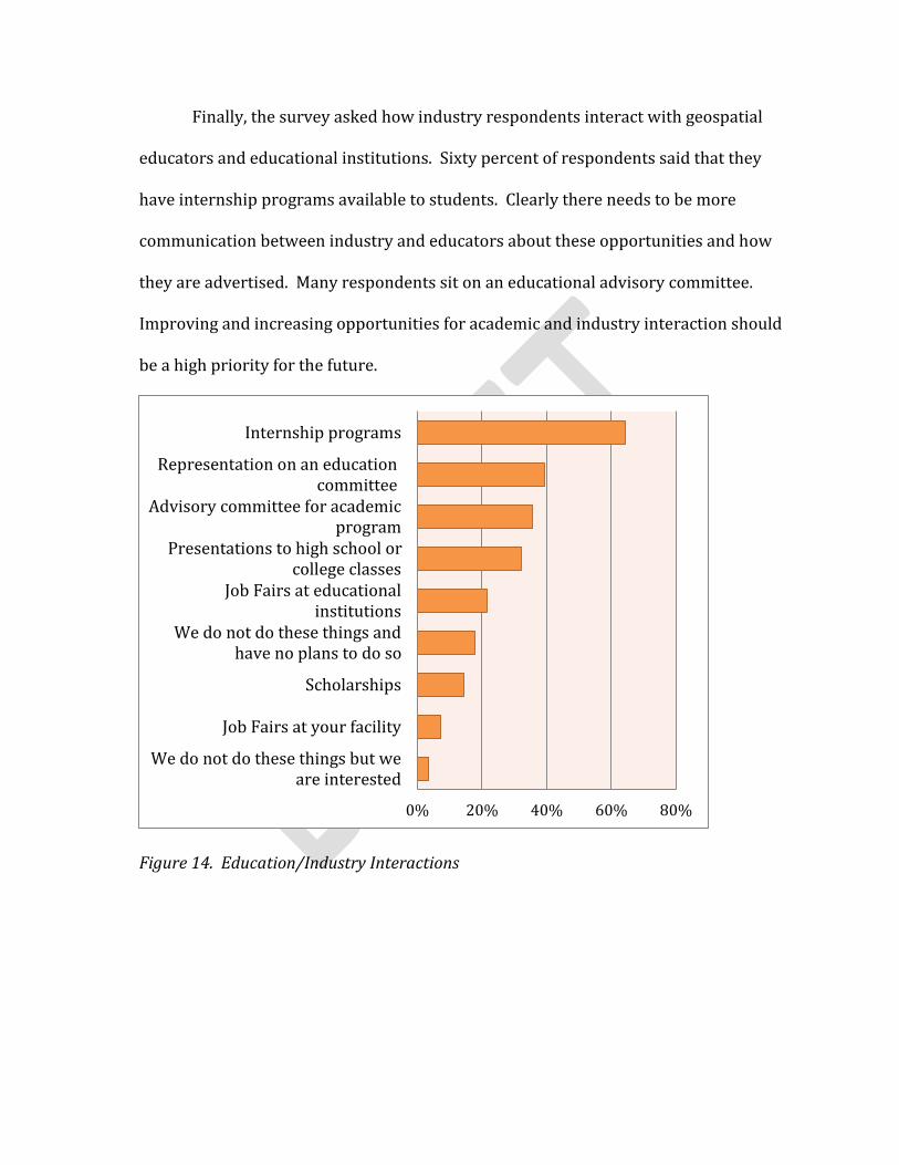
The employment outlook for geospatial employees as reflected by the survey is
mediocre. Though the news is good for existing employees, only 18% of employers
reported that they would be hiring at least one new employee this year.
Figure 13. Employment outlook
0% 20% 40% 60%
Never have advertised
Professional Contacts
Educational Contacts
Train existing employees
Government hiring processes
Internet and other outlets
0% 20% 40% 60% 80%
Not good, we will be laying offgeospatial employees
Very good, we anticipate hiringseveral this year
Good, we anticipate hiring atleast one this year
Stable, we plan on keeping allgeospatial employees
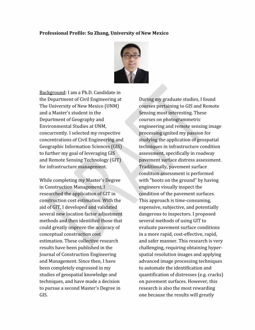
Finally, the survey asked how industry respondents interact with geospatial
educators and educational institutions. Sixty percent of respondents said that they
have internship programs available to students. Clearly there needs to be more
communication between industry and educators about these opportunities and how
they are advertised. Many respondents sit on an educational advisory committee.
Improving and increasing opportunities for academic and industry interaction should
be a high priority for the future.
Figure 14. Education/Industry Interactions
0% 20% 40% 60% 80%
We do not do these things but weare interested
Job Fairs at your facility
Scholarships
We do not do these things andhave no plans to do so
Job Fairs at educationalinstitutions
Presentations to high school orcollege classes
Advisory committee for academicprogram
Representation on an educationcommittee
Internship programs
Professional Profile: Su Zhang, University of New Mexico
Background: I am a Ph.D. Candidate in
the Department of Civil Engineering at
The University of New Mexico (UNM)
and a Master’s student in the
Department of Geography and
Environmental Studies at UNM,
concurrently. I selected my respective
concentrations of Civil Engineering and
Geographic Information Sciences (GIS)
to further my goal of leveraging GIS
and Remote Sensing Technology (GIT)
for infrastructure management.
While completing my Master's Degree
in Construction Management, I
researched the application of GIT in
construction cost estimation. With the
aid of GIT, I developed and validated
several new location factor adjustment
methods and then identified those that
could greatly improve the accuracy of
conceptual construction cost
estimation. These collective research
results have been published in the
Journal of Construction Engineering
and Management. Since then, I have
been completely engrossed in my
studies of geospatial knowledge and
techniques, and have made a decision
to pursue a second Master's Degree in
GIS.
During my graduate studies, I found
courses pertaining to GIS and Remote
Sensing most interesting. These
courses on photogrammetric
engineering and remote sensing image
processing ignited my passion for
studying the application of geospatial
techniques in infrastructure condition
assessment, specifically in roadway
pavement surface distress assessment.
Traditionally, pavement surface
condition assessment is performed
with "boots on the ground" by having
engineers visually inspect the
condition of the pavement surfaces.
This approach is time-consuming,
expensive, subjective, and potentially
dangerous to inspectors. I proposed
several methods of using GIT to
evaluate pavement surface conditions
in a more rapid, cost-effective, rapid,
and safer manner. This research is very
challenging, requiring obtaining hyper-
spatial resolution images and applying
advanced image processing techniques
to automate the identification and
quantification of distresses (e.g. cracks)
on pavement surfaces. However, this
research is also the most rewarding
one because the results will greatly
improve the geospatial intelligence
capability of infrastructure
management agencies.
Current Status: Currently I am still a
student at UNM. As aforementioned,
my goal is to leverage GIS and Remote
Sensing Technology (GIT) for
infrastructure management. Therefore,
I want to apply a position that applies
GIT for infrastructure management. It
could be some companies that
traditionally specializing in civil
engineering but currently exploring the
geospatial fields, such as Wilson &
Company and Bohannan Houston.
Opinion on Job Market: In my opinion,
there are many available jobs in New
Mexico in the various geospatial
professions, although it is less when
comparing with other states such as
Colorado. The strengths that I can see
in the state are that we have a lot of
research institutions in New Mexico
such as Sandia National Lab and
Kirtland Air Force Lab that may
provide a lot of jobs related to
geospatial professions. The
weaknesses that I can see in the state
are that we do not have a lot of
openings in recent years, which cannot
provide enough positions to fresh
graduates. They need to go to other
states such as Colorado to start their
geospatial careers. I think it is a good
idea to initiate a statewide geospatial
internship program to help fresh
graduates to get training and
experience to start their career.
Opinion on Training: I barely know
there is available training in New
Mexico in the various geospatial
professions. I might be incorrect, but I
have never had a chance to get
information about the training.
Advice to Students: My suggestion is
that students should smartly use their
time to learn as much as can while they
are in school. The more you do, the
more you learn. This is the bottom-line.
I have been participated in many
different research projects and learn a
lot from them. Currently I am
completing my Ph.D. degree and I feel
confident to start a career in geospatial
professions. Another suggestion is that
students should join professional
organization such as New Mexico
Geographic Information Council
(NMGIC) or American Society of
Photogrammetry and Remote Sensing
(ASPRS) to develop their professional
network.
Advice to Teachers: There is one really
important thing I want to suggest, that
is, providing more courses that are
related to geospatial professions.
Currently we do not have a broad
range of options and it is always good
to add more courses to the curriculum.
In addition, teachers should more
actively interact with students to know
what they want, what they need.
Advice to Employers: I suggest that
employers provide more internship
opportunities to fresh graduates or
students to start developing their skills
earlier. Currently most of jobs require
applicants to have several years’
experience in geospatial profession
which impeded students to pursue

their career. In addition, employers
should establish connections with
universities and colleges to expose
their requirements, which can
significantly improve students’ skills
and make them ready to work.
Conclusions
New Mexico is home to a variety of opportunities for training in the geospatial
fields and provides a variety of opportunities for employment as well. Our goal for
this document is to energize the members of NMGIC to engage the two aspects to
create the best pathways to a geospatial career possible.
A variety of respondents provided information but, as evidenced in Figure 1, we did
not receive any responses from the southern parts of the state. Nor did we receive
responses from tribal professionals. This document also does not provide
information on available geospatial programs at the K-12 level or the programs
available to people in New Mexico online. It is our hope that in future surveys we can
broaden and expand our responses for a better picture of Pathways in New Mexico.
Nevertheless several trends are apparent.
Soft skills are the most desired by employers. The survey suggests the current
model is to train people after hiring to excel in a particular geospatial skill set in such
as a way as to meet the mission of the company or agency. A high quality candidate
for employment should have experience with such skills as public speaking, report
writing, and time management.
Given the large amount of public lands in New Mexico and the large number of
respondents from the government fields, it was not surprising to find natural
resources to be the top industry using geospatial technology. It is likely both natural
resources and government will be drivers in the Pathways in New Mexico for many
years to come.
Desktop work remains the most commonly used form of geospatial technology
in the state with web-based GIS right behind it; in all likelihood those are correlated.
The result of low use of non-proprietary or “open” software is intriguing given the
long history of NMGIC members making use of such software and may reflect who
responded to the survey more than the actual percentage in the state. The result of a
high percentage of respondents using esri technology is not unexpected, given the
long history of the company in the industry and its strong use by government at all
levels. A perspective employee would be wise to be familiar with the products and
features of the company.
Employment patterns seem to reflect a non-standard path to being hired in
that a variety of degrees training are accepted. Respondents indicated they are
generally willing to train employees to get up to speed on the use of geospatial
technologies to meet their company missions. It would be interesting to see, in the
future, more respondents from specialized fields like photogrammetry and from
salespeople that sell such products as LiDAR and orthophotography, specifically if
they would require more training prior to hiring a new employee. Another
employment pattern seen in the survey is that while a few respondents worked in
companies with more than 20 people, often as part of a national organization, most
shops are small. This, along with the pattern of training after hiring, suggests that
employers seek to tailor their geospatial employees to their specific needs, that the
employee may work on more than geospatial technology on the job, and that a well-
rounded education, including soft skills is of prime importance. The primary way
toward that education-and experience-is currently through internships. Based upon
the survey, dialog between employers and educators is on an ad-hoc basis, often
through volunteering to be on an academic committee.
Lastly, data-production, maintenance, and publication-was the primary focus
for what the respondents did for a living. This is not a surprise as this is a data-based
field and it is our opinion data represents many new opportunities for future
employees. For instance, open, big, and smart data are all becoming increasingly
important at all levels of society; positions like a data information officer will become
more commonplace. How this should be managed in terms of education-under
programming or GIS-and where such positions should be placed within a company-
potion unto itself, or like the current model, adapted to the overall company mission-
will be points of discussion the future.
In summary, a well rounded employee is desired with a variety of skill sets,
particularly the soft skills and, in all likelihood, familiarity with web programming and
data management. Jobs are out there, as is training, but they are communicating on
an ad-hoc basis. Data efforts like LiDAR and new imagery are creating needs for data
management and analysis, and the every-growing use of the web calls for more
geospatial employees in fields like broadband and web design. One of the authors
heard a talk by an industry leader lamenting that he had the funds to employ a young
professional and found many who had the GIS skills for his broadband initiatives but
all of them lacked the speaking skills to deal with the public; another young
professional was stuck trying to determine if she should be invest more of her
training toward geospatial programming or geospatial analysis in order to land a good
job. To overcome such problems more dialog is needed between employers,
educators, and students. It is our hope that this document and future versions of it
will encourage NMGIC members to provide opportunities to make that dialog a
reality.
References
DiBiase, D., DeMers, M., Johnson, A., Kemp K., Luck, A.T., Plewe, B. and Wentz, E.
(2006). The Geographic Information Science and Technology Body of Knowledge, First
Ed. Washington, D.C.: Association of American Geographers.