Embed Size (px)
Citation preview

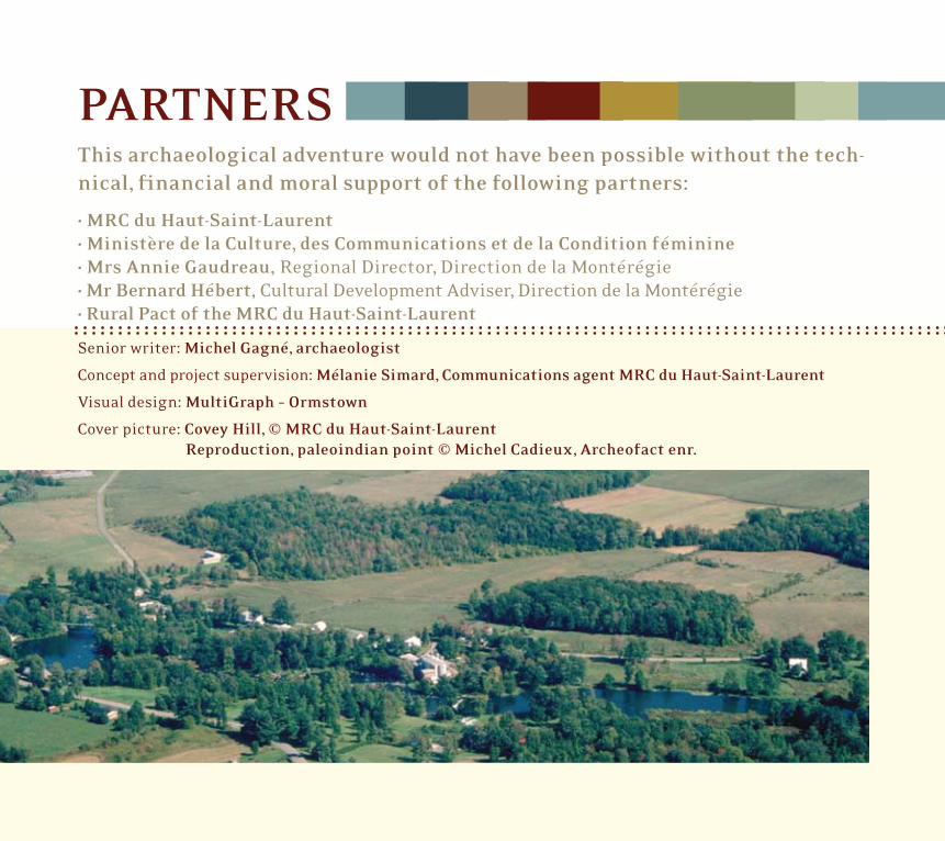
PARTNERSThis archaeological adventure would not have been possible without the tech-nical, financial and moral support of the following partners:
• MRC du Haut-Saint-Laurent• Ministère de la Culture, des Communications et de la Condition féminine• Mrs Annie Gaudreau, Regional Director, Direction de la Montérégie• Mr Bernard Hébert, Cultural Development Adviser, Direction de la Montérégie • Rural Pact of the MRC du Haut-Saint-Laurent
Senior writer: Michel Gagné, archaeologist
Concept and project supervision: Mélanie Simard, Communications agent MRC du Haut-Saint-Laurent
Visual design: MultiGraph – Ormstown
Cover picture: Covey Hill, © MRC du Haut-Saint-Laurent Reproduction, paleoindian point © Michel Cadieux, Archeofact enr.
ACKNOWLEDGMENTWe would like to extend our warmest thanks to the following persons and organi-zations that, in one way or another, have encouraged, supported or participated in publicizing the MRC du Haut-Saint-Laurent archaeological research project.
The land owners who have given their consent to explore on their land, including France Droulers of Ferme Biophile; Bruno Quesnel; Alain Droulers; Denis Mailhot; Bruce, John and the late George Irving; Kevin Staveley; Orrick Thurston; Jacques Leblanc; the late Thomas M. Higgins; and the firm Caza et fils of Cazaville.
Agathe Brisebois, President of the Société historique de Saint-Anicet.
The late André Bouchard, Professor in the Biological Science Department at the Université de Montréal.
Philippe Decloître, Teacher at the Arthur-Pigeon secondary school in Huntingdon.
Pierre Meilleur, Surveyor, Huntingdon.
Pascal Perron and Michel Cadieux of Archéofact, respectively Director and Coordinator of the Interpretation Centre of the National Historic Droulers-Tsiionhiakwatha site in Saint- Anicet.
André Castagnier, Director of the newspaper, the Hunting-don Gleaner.
Connie McClintock-Wilson and Denise Touchette as well as Robert McGee, respectively President and members of the Chateauguay Valley Historical Society.
Sally Benedict of the Mohawk Council Akwesasne.
Denise St-Germain and Jean-Marie Latreille and the mem-bers of the Centre d’intendance écologique Latreille in Saint- Anicet.
Ginette Quesnel and Monsieur Gratien Quesnel of Saint-Anicet.
The late James F. Pendergast from the Canadian Museum of Civilization.
Norman Clermont, Claude Chapdelaine, Adrian Burke, Roland Viau and Pierre Corbeil, respectively professors, lecturer and manager of the Archaeological Excavation Laboratory and some 90 students from the Department of Anthropology at the Université de Montréal who participated in the archaeo-logical activities in Saint-Anicet between 1992 and 2000.
Pierre Richard, Pierre Gangloff, Alayn Larouche and Marc Delage, respectively Professor, Paleobotanist and past doc-toral student in the Geography Department at the Université de Montréal.
Greg Kennedy, Professor at the Institut de génie nucléaire, École Polytechnique de Montréal.
Louise Pothier and Sophie Limoges, respectively Director, Exhibitions-Technology, and Director, Conservation–Public Programs, Pointe-à-Callière, Musée d’archéologie et d’histoire de Montréal.

TABLE OF CONTENTSPreface
FromAlainCastagner,prefect . . . . . . . . . . . . . . . . . . . . . . . . . . . . 4
FromMichelGagné,archaeologist . . . . . . . . . . . . . . . . . . . . . . . . 4
Apastcoveringmanymillennia . . . . . . . . . . . . . . . . . . . . . . . . . . . . . . . . 5
CoveyHill,12,500yearsago . . . . . . . . . . . . . . . . . . . . . . . . . . . . . . . . . . . . . 6
Ahostileenvironment . . . . . . . . . . . . . . . . . . . . . . . . . . . . . . . . . . . . . . . . . . 7
Thearrivalofthefirsthumans . . . . . . . . . . . . . . . . . . . . . . . . . . . . . . . . 7
TheArchaicperiodontheChateauguayRiver . . . . . . . . . . . . . . . . . 8
Aconstantlyevolvinglandscape . . . . . . . . . . . . . . . . . . . . . . . . . . . . . . . 9
AnimportantsitefromtheArchaicPeriod . . . . . . . . . . . . . . . . . . . . 9inTrès-Saint-Sacrement
ThetimeoftheIroquoiansinSaint-Anicet . . . . . . . . . . . . . . . . . . . . . 10between1300and1600A .D .
Corn,beansandsquash:thethreesistersoflife . . . . . . . . . . . . . . 11
Afeminineuniverse . . . . . . . . . . . . . . . . . . . . . . . . . . . . . . . . . . . . . . . . . . . . . 12
Theseasons . . . . . . . . . . . . . . . . . . . . . . . . . . . . . . . . . . . . . . . . . . . . . . . . . . . . . 12
Adiversifiedenvironment . . . . . . . . . . . . . . . . . . . . . . . . . . . . . . . . . . . . . . 13
Extremelyvaluablearchaeologicalsites . . . . . . . . . . . . . . . . . . . . . 14
Andifthiswasjustthetipoftheiceberg? . . . . . . . . . . . . . . . . . . . . . 15

FROM ALAIN CASTAGNER, PREFECT
It is with pride that we have put together this booklet, companion of the publica-tion Saint-Anicet, an exceptional archaeological inheritance. We invite you to keep them both and use them as reference tools on the archaeological past so rich of our region.
This document makes us rediscover the Haut-Saint-Laurent and offers a glance at a vanished age of which history is revealed through the excavations of the numerous archaeological sites that crisscross our region.
The territory of the Haut-Saint-Laurent has a richness that has not yet finished to unfold. Constant efforts have helped to update a legacy of remarkable cultural signifi-cance. However, there is still some ways to go if we want to reveal to future genera-tions the treasures that our corner of the country still holds.
We hope that this document will instruct and captivate you. Happy reading!
Alain Castagner, prefect MRC du Haut -Saint-Laurent
4
FROM MICHEL GAGNÉ, ARCHAEOLOGIST
It is with renewed pleasure that I invite you to browse through this book, which of-fers a glimpse into the archaeological past of the three major regions of the Haut-Saint-Laurent; Covey Hill, the Chateauguay River Basin and the area around Lake Saint-François. We will discover that over the millennia, human groups were gradu-ally established in these uncharted territories, they discovered various types of en-vironments and have learned to utilize the resources available to them.
I dedicate this booklet to all lovers of the region’s cultural history who have care-fully preserved the relics of the past and then forwarded them to their descendants. It is primarily due to their desire to benefit the whole community that I can now offer these few pages of the book on the adventure of human settlement in the Haut-Saint-Laurent. Without their invaluable contributions, a large part of the his-tory of your area would have vanished forever.
Michel Gagné, archaeologist

A PAST COVERING MANY MILLENNIA
5
For as long as we can remember, mankind has always been fascinated by the discovery of objects from the past. Every land owner has experienced the delight of finding a fragment of an ancient dish, an antique cast-iron tool, old coin or even a stone arrowhead sometimes shaped over a thou-sand years ago. If these objects could speak, they would surely tell us many stories filled with picturesque details of the lives of the people for whom these remains were common objects. However, in reality, when it comes to the age, origin or even the function of these objects discovered by chance, our questions frequently remain unanswered. Particularly since often we find only a few pieces of the massive puzzle which would create a portrait of the way of life of these populations, now long gone.
It is in this context that archaeology takes on its true meaning. By pains-takingly gathering these clues from the ground, comparing them, docu-menting and noting the circumstances of their discovery, the archaeolo-gist manages to broaden his investigation so that these efforts bear fruit. When placed side-by-side, these clues allow us to write a page of the cul-tural history of the people who lived in the region so long ago.
This is what archaeologists in Quebec have attempted to do for close to 40years. Inventories made over time have allowed us to discover thousands of archaeological sites, revealing human occupation over 12,000 years ago. In this way, we have found cultural evidence that archaeologists clas-sify according to periods, bearing the evocative names of Paleoindian, Archaic and Early Woodland.
We therefore invite you to join us on a voyage in time to meet the commu-nities which have marked the ancient history of our three main regions in the MRC: Covey Hill, the Chateauguay River Basin and the Municipa-lity of Saint-Anicet.
MODERN
EARLY WOODLAND
ARCHAIC
PALEOINDIAN
Covey Hill Approximately 12500
years before today
Chateauguay River
Approximately 5000 years before today
Iroquoians of Saint-Anicet
Approximately between 1300 and 1500 AD
Year 1: Beginning of the Christian Era
13500 years before today
3000 years before today
Today
Contact period (1500–1650)
8500 years before today

Originally from Eastern Asia, the first humans pro-bably set foot on the American continent 20,000 years ago. They undertook a long journey around the glacial mass which covered most of Canada at the time. Around 12,500years ago, they finally arrived at the gateway to, what is now, Quebec. These small groups of highly mobile nomads, representing just a few families (probably fewer than 25 people), moved over vast territories according to the availability of their food sources. Occasionally, they lived for short periods in little circular huts. At this time, their livelihood depended mainly on large game, particularly caribou, and small mam-mals, such as the beaver. From time to time, they also added fish to their diet.
They were skilled hunters, as demonstrated by the presence of caribou remains disco-vered at certain Paleoindian archaeological sites. This fact was particularly impressive since their only hunting tools were extreme-ly rudimentary, a simple wooden lance topped by a cut-stone projectile point. The projectile points used by these Paleoindians were marked by the presence of longitudinal grooves along the centre portion, generally on both sides, from the base to near the middle of the point, thereby facilitating their at-tachment to the end of the lance.
At first sight, from our sedentary lifestyle and easier living conditions, the Paleoindians appeared little equipped to encounter game such as caribou, with its
highly developed sense of hearing and smell, particu-larly since a large male could weigh up to 250 kg.
This enormous cervid, highly resistant and perfect-ly adapted to its environment, could move about easily on the crusted snow thanks to its elon-gated hoofs, and reach speeds of up to 60 km an hour. In certain situations, when pursued, they could maintain a pace of 40 km/hour for up to an hour at a time.
In spite of everything, using cunning and natural traps, these early inhabitants ma-naged to attract their favourite game and gather the fruit of their labour. In addition to the projectile tips, they had a wide range of stone tools, including scrapers and knives made of cut-stone, with which they treated the carcass to transform it into food and clothing adapted to the harsh climate that
prevailed at this far off time.
COVEY HILL, 12,500 YEARS AGO
6
Covey Hill © MRC du Haut-Saint-Laurent
Reproduction Paleoindian point © Michel Cadieux,
Archéofact enr.
THE ARRIVAL OF THE FIRST HUMANS
Around 12,500 years ago, the first Paleoindian hunters roamed along the shores of the Champlain Sea. Their traces have been found less than 50 km from Covey Hill where a typical projectile point dating from this period was discovered. Their constant movement in search of food surely encouraged them to go farther north, towards Covey Hill, which, at the time, represented the northern boundary of the emerged land. This area must have offered an environment favourable to captu-ring their coveted game. Particularly since, at the time, it also boasted a fresh-water pond providing a source of drinking water surround by fresh grasses which certainly must have attracted the caribou. This water body later developed into a bog, known as the « tourbière du Gouffre », which still exists today in the Municipality of Havelock. It is very probable that these early hunters’ wanderings along the flanks of Covey Hill brought them to the edges of the Municipalities of Franklin and Hinchinbrooke.
A HOSTILE ENVIRONMENT
7
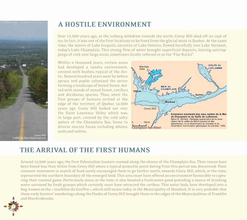
Over 13,500 years ago, as the iceberg withdrew towards the north, Covey Hill shed off its coat of ice. In fact, it was one of the first locations to be freed from the glacial mass in Quebec. At the same time, the waters of Lake Iroquois, ancestor of Lake Ontario, flowed forcefully into Lake Vermont, today’s Lake Champlain. This strong flow of water brought superficial deposits, leaving outcrop-pings of rock over large areas, sometimes locally referred to as the “Flat Rocks”.
Within a thousand years, certain areas had developed a tundra environment, covered with bushes, typical of the Arc-tic. Several hundred years went by before spruce and poplar colonized the sector forming a landscape of boreal forest, dot-ted with stands of mixed forest, conifers and deciduous species. Thus, when the first groups of humans arrived at the edge of the territory of Quebec 12,500 years ago, Covey Hill looked out over the Saint Lawrence Valley which was, in large part, covered by the cold salty waters of the Champlain Sea, home to diverse marine fauna including whales, seals and walrus.
Covey Hill © MRC du Haut-Saint-Laurent
Champlain Sea (blue)
Covey Hill
THE ARCHAIC PERIOD ON THE CHATEAUGUAY RIVER
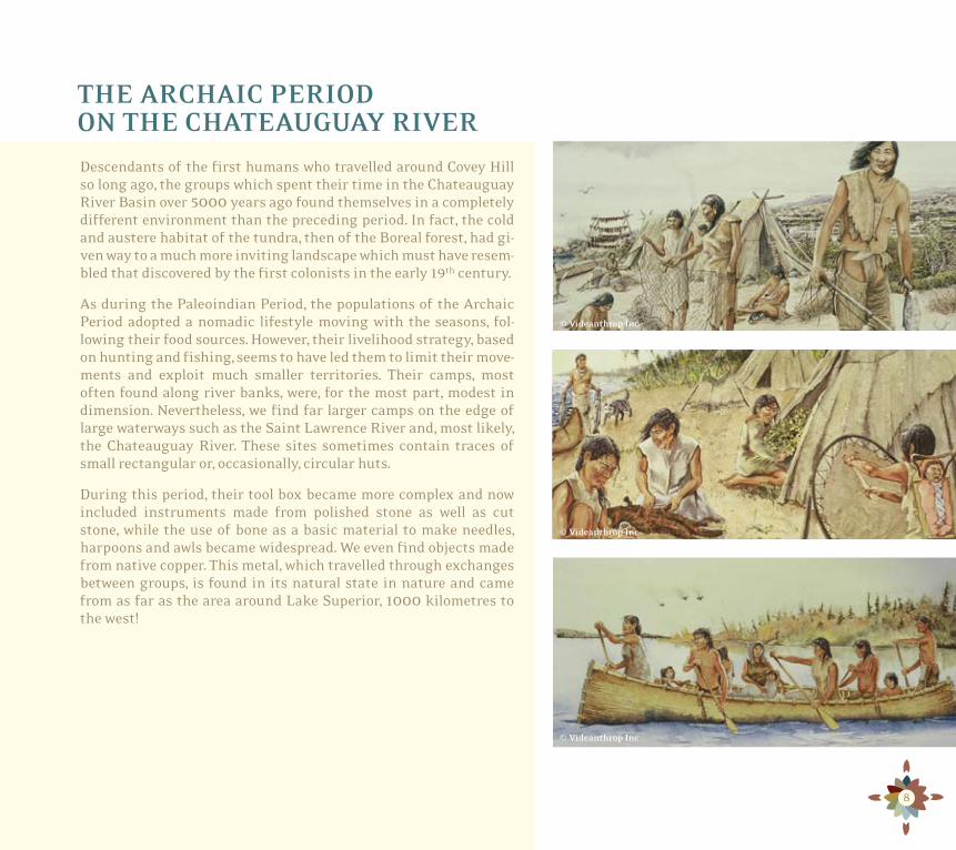
Descendants of the first humans who travelled around Covey Hill so long ago, the groups which spent their time in the Chateauguay River Basin over 5000 years ago found themselves in a completely different environment than the preceding period. In fact, the cold and austere habitat of the tundra, then of the Boreal forest, had gi-ven way to a much more inviting landscape which must have resem-bled that discovered by the first colonists in the early 19th century.
As during the Paleoindian Period, the populations of the Archaic Period adopted a nomadic lifestyle moving with the seasons, fol-lowing their food sources. However, their livelihood strategy, based on hunting and fishing, seems to have led them to limit their move-ments and exploit much smaller territories. Their camps, most often found along river banks, were, for the most part, modest in dimension. Nevertheless, we find far larger camps on the edge of large waterways such as the Saint Lawrence River and, most likely, the Chateauguay River. These sites sometimes contain traces of small rectangular or, occasionally, circular huts.
During this period, their tool box became more complex and now included instruments made from polished stone as well as cut stone, while the use of bone as a basic material to make needles, harpoons and awls became widespread. We even find objects made from native copper. This metal, which travelled through exchanges between groups, is found in its natural state in nature and came from as far as the area around Lake Superior, 1000 kilometres to the west!
© Videanthrop Inc
© Videanthrop Inc
© Videanthrop Inc
8
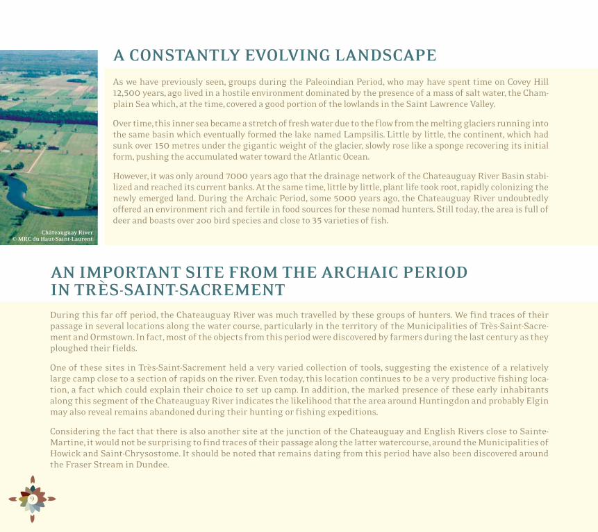
As we have previously seen, groups during the Paleoindian Period, who may have spent time on Covey Hill 12,500 years, ago lived in a hostile environment dominated by the presence of a mass of salt water, the Cham-plain Sea which, at the time, covered a good portion of the lowlands in the Saint Lawrence Valley.
Over time, this inner sea became a stretch of fresh water due to the flow from the melting glaciers running into the same basin which eventually formed the lake named Lampsilis. Little by little, the continent, which had sunk over150 metres under the gigantic weight of the glacier, slowly rose like a sponge recovering its initial form, pushing the accumulated water toward the Atlantic Ocean.
However, it was only around 7000 years ago that the drainage network of the Chateauguay River Basin stabi-lized and reached its current banks. At the same time, little by little, plant life took root, rapidly colonizing the newly emerged land. During the Archaic Period, some 5000 years ago, the Chateauguay River undoubtedly offered an environment rich and fertile in food sources for these nomad hunters. Still today, the area is full of deer and boasts over 200 bird species and close to 35 varieties of fish.
9
During this far off period, the Chateauguay River was much travelled by these groups of hunters. We find traces of their passage in several locations along the water course, particularly in the territory of the Municipalities of Très-Saint-Sacre-ment and Ormstown. In fact, most of the objects from this period were discovered by farmers during the last century as they ploughed their fields.
One of these sites in Très-Saint-Sacrement held a very varied collection of tools, suggesting the existence of a relatively large camp close to a section of rapids on the river. Even today, this location continues to be a very productive fishing loca-tion, a fact which could explain their choice to set up camp. In addition, the marked presence of these early inhabitants along this segment of the Chateauguay River indicates the likelihood that the area around Huntingdon and probably Elgin may also reveal remains abandoned during their hunting or fishing expeditions.
Considering the fact that there is also another site at the junction of the Chateauguay and English Rivers close to Sainte-Martine, it would not be surprising to find traces of their passage along the latter watercourse, around the Municipalities of Howick and Saint-Chrysostome. It should be noted that remains dating from this period have also been discovered around the Fraser Stream in Dundee.
Châteauguay River © MRC du Haut-Saint-Laurent
AN IMPORTANT SITE FROM THE ARCHAIC PERIOD IN TRÈS-SAINT-SACREMENT
A CONSTANTLY EVOLVING LANDSCAPE

THE TIME OF THE IROQUOIANS IN SAINT-ANICET BETWEEN 1300 AND 1600 A.D.
Several thousand years have passed since the first human beings set foot on the soil of the Haut-Saint-Laurent. We are now at the dawn of the 14th century, a period of great change during which the inhabitants’ lifestyle gradually shifted from a nomadic to a more sedentary way of life.
By the beginning of 1300, that is during the second half of the period archaeolo-gists now refer to as the Early Woodland, groups gradually began to set up dwel-lings in the Saint-Anicet area. These people are commonly referred to as the Saint Lawrence Iroquoian, after the river which served as their main navigational route. These Iroquoian are the forefathers of those that Jacques Cartier met in 1535 du-ring his trips to Stadaconé, now the City of Québec, and to the village known as Hochelaga on the Island of Montreal.
These communities, which lived along the Saint Lawrence River, were part of the same linguistic family as the Hurons and Mohawks and shared similar ways of life and culture. They were sedentary farmers who lived in village groups. The social and political life of these Iroquoian communities was also relatively similar.
During this period of over almost three centuries, the Saint Lawrence Iroquoians erected villages grouping several long houses on the slopes of the back country around Saint-Anicet. These rectangular dwellings, from 15 to 30 metres (50 to 100 feet) long by approximately 6 metres (20 feet) wide and tall, were constructed of wooden poles, bent and curved, linked together by cords and sunk into the ground. The arch-shaped roof was covered with large slabs of cedar and sometimes elm bark. Several hearths were installed along the central corridor with sleeping benches on each side. Usually the dwelling was accessed through doors located at the ends. Occasionally palisades circled the villages to protect the occupants from enemies, wild animals or bad weather.
Iroquoian Long House reproduction © Aventuriers de l’archéologie dans le Haut-Saint-Laurent
10
La Guerre River © MRC du Haut-Saint-Laurent, picture Michel Gagné

11
From the time they settled in the Saint-Anicet area, through experimentation, the Iroquoians gradually mastered the rudiments of growing corn. This know-how, dating back several thousand years, arrived through a long network of exchanges originating much further south, in Mexico. The migratory route of corn took a path through Mississippi, going on to the Great Lakes and finally up the Saint Lawrence River.
For the Iroquoians of Saint-Anicet, surpluses from their horticultural activities gradually stabilized their food supply throughout the year. Beginning in 1400, beans and squash also became an impor-tant crop. At the time, this production was mainly the task of the women, who grew their crops close to the village. First the fields were cleared by burning the forest. Then the garden was cleared and small hillocks created and seeded by using a simple stick to make a hole in the ground and bury the seeds. After the harvest, several procedures were used to preserve the corn, including air drying inside the dwellings, initial roasting of the cobs, or the grain was simply stored in pantry pits dug into the floor of the dwellings and lined with bark.
CORN, BEANS AND SQUASH: THE THREE SISTERS OF LIFE
© Videanthrop Inc © Videanthrop Inc
© Ramuzio, terzio volume delle navigatione viaggi, 1959.

A FEMININE UNIVERSE
At this time, women held an important position in Iroquoian society. In fact, all community and social life gravitated around them. In this way, each individual was identified by his or her maternal line, then by clan. Each long house in a village grouped women from a single maternal clan. The men living with them came from clans other than those of the related women, mothers and daugh-ters, residing in the same home, the maternal home. According to this practice, all men born of women belonging to a clan, necessarily, sooner or later, on their marriage, went to live in the home of their wife, therefore, obligatorily in an-other clan.
In each long house, the reins of power were held by the oldest woman in the dwelling who acquired the status of “clan mother”. She was the one to rule the social and economic organization of the entire dwelling. Amongst others, the clan mothers had the power to choose chiefs and spiritual leaders and to remove them from office.
Iroquoian women pounding corn © François Du Creux, Historiae canadensis, 1664
12
THE SEASONS
The cycle of the seasons had a significant influence on the intensity of activities in the villages. Hunting and fishing took the men away, particu-larly in the spring and autumn, while the summer and early autumn were de-voted to seeding, maintaining the fields, harvesting and collecting wild fruit, mainly tasks carried out by the women and children. Consequently, the most intensive portion of their social life mainly took place in winter between December and March. This was also the period during which their agricul-tural surpluses were most important.
However, gradually, without additional fertilizers, the land became less pro-ductive. Yields decreased, obliging the Iroquoians to regularly change the position of their fields. The areas cultivated became farther and farther from the village. This factor, as well as the gradual breakdown of the dwellings and scarcity of game due to intensive hunting, led to the relocation of the village every 10 to 20 years.
© Videanthrop Inc.

13
A DIVERSIFIED ENVIRONMENTAlong with the first French, Scottish and Irish colonists who inhabited the sector in the early 19th century, the first Iroquoians to penetrate the back lands of Saint-Anicet discovered a very contrasting landscape com-prising a vast clay plain subject to regular flooding and dotted with rocky well-drained hills covered with sand. The area also contained peat bogs and impenetrable marshes that covered large surfaces.
At this time, the stretches of sand found around Cazaville were mainly covered with forests of majestic white pine, while hard wood species: maples, beech and basswood, were found mainly on the rocky hills. The approaches to La Guerre River revealed a considerable quantity of oaks and tall pines, while the humid areas, bogs and marshes, were full of cedar and tamarack mixed with elm and black ash.
These varied ecosystems were home to a variety of spe-cies of fauna, more or less the same as those found at the beginning of this period of history. Among others, the colonists at the time mentioned the abundance of deer, particularly on the hills and around the peat bogs. The area was also home to a several predators, including wolves and bears, which decimated the domestic live-stock of the early colonists. There were also many bea-ver dams close to the marshy areas. As now, there were many small mammal species, including hares, ground-hogs, raccoons, skunks and porcupines. Bone remains of all these species have been found when digging in the archaeological village sites in Saint-Anicet.
At the same time, Lake Saint-François, as well as La Guerre River, were certainly an inexhaustible source of water resources for the Iroquoian of the time. Trout, among others, were abundant in the streams of Saint-Anicet’s back lands, while we still find several large spawning grounds for perch and largemouth bass at the mouth of La Guerre River and in the Bay of Saint-Anicet. The remains of 17 species of fish have also been disco-vered on the Mailhot-Curran site in Godmanchester.
In the light of this information, there is no doubt that the area harboured a rich and diversified range of fauna and flora at this long ago period as it does today. For ex-ample, the area around the Lac Saint-François National Wildlife Area currently counts the presence of close to 600plant species, 53 types of mammal, 223 bird species, 16types of amphibian and 8 varieties of reptile.
©North America Colonial Association of Ireland,1840

Cazaville 2Cazaville 3
CazavilleCaza
EXTREMELY VALUABLE ARCHAEOLOGICAL SITES
It is now common knowledge that the Municipality of Saint-Anicet has several major archaeological sites da-ting from the time of the first Iroquoian farmers, the most important of which is undoubtedly the Droulers-Tsiionhiakwatha site. Occupation of this important site, now recognized as a national historic site in Canada, dates back to 1450 A.D.
However, we have also found another important archaeo-logical site in the Municipality of Godmanchester, the Mailhot-Curran site, which dates back to around 1500. Lastly, the trilogy of Iroquoian villages discovered so far also includes the McDonald site, the oldest established village to be documented in Quebec, dating back to 1320 A.D. This site is also within the boundaries of the Munici-pality of Saint-Anicet.
But what characterizes the Iroquoian presence most in the greater Saint-Anicet region, and in fact what makes it an exceptional region, remains the abundance and diver-sity of the clues scattered throughout the territory, cove-ring the entire period of occupation. The traces left by the Iroquoians reveal the remains of villages, hunting and fishing camps, horticultural settlements and rock pick-ing activities, probably resulting from agricultural activi-ties. In effect, the region now boasts being host to a group of archaeological sites that best represent the world of the Iroquoians at the time discovered in the Saint Law-rence Valley, not to mention the sites still unknown that we expect to be plentiful in the unexplored territories of the Municipalities of Dundee and Sainte-Barbe.
14
DundeeAkwesasne
Saint-Anicet
Sainte-Barbe
Huntingdon
Godmanchester
Ormstown
Howick
Très-Saint- Sacrement
Saint- Chrysostome
FranklinHavelock
HinchinbrookeElgin
Berry
Leblanc
Angus McPhersonIrving Higgins
Staveley
Godmanchester
HamiltonMerson
Calincross
McDonald
Droulers-Tsiionhiakwata
Mailhot-Curran
Covey Hill
SITE LOCATIONS Specialized sites Villages
Map of the MRC du Haut-Saint-Laurent’s territory © MRC du Haut-Saint-Laurent
15
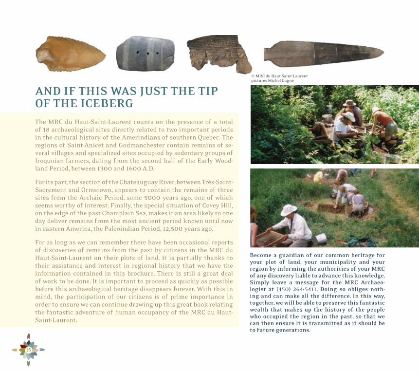
AND IF THIS WAS JUST THE TIP OF THE ICEBERGThe MRC du Haut-Saint-Laurent counts on the presence of a total of 18 archaeological sites directly related to two important periods in the cultural history of the Amerindians of southern Quebec. The regions of Saint-Anicet and Godmanchester contain remains of se-veral villages and specialized sites occupied by sedentary groups of Iroquoian farmers, dating from the second half of the Early Wood-land Period, between 1300 and1600 A.D.
For its part, the section of the Chateauguay River, between Très-Saint-Sacrement and Ormstown, appears to contain the remains of three sites from the Archaic Period, some 5000 years ago, one of which seems worthy of interest. Finally, the special situation of Covey Hill, on the edge of the past Champlain Sea, makes it an area likely to one day deliver remains from the most ancient period known until now in eastern America, the Paleoindian Period, 12,500 years ago.
For as long as we can remember there have been occasional reports of discoveries of remains from the past by citizens in the MRC du Haut-Saint-Laurent on their plots of land. It is partially thanks to their assistance and interest in regional history that we have the information contained in this brochure. There is still a great deal of work to be done. It is important to proceed as quickly as possible before this archaeological heritage disappears forever. With this in mind, the participation of our citizens is of prime importance in order to ensure we can continue drawing up this great book relating the fantastic adventure of human occupancy of the MRC du Haut-Saint-Laurent.
Become a guardian of our common heritage for your plot of land, your municipality and your region by informing the authorities of your MRC of any discovery liable to advance this knowledge. Simply leave a message for the MRC Archaeo- logist at (450) 264-5411. Doing so obliges noth-ing and can make all the difference. In this way, together, we will be able to preserve this fantastic wealth that makes up the history of the people who occupied the region in the past, so that we can then ensure it is transmitted as it should be to future generations.
© MRC du Haut-Saint-Laurent pictures Michel Gagné