Embed Size (px)
Citation preview

This project is funded by the USFWS Competitive State Wildlife Grant Program and the Foundation for Food and Agricultural Research Cover photo: Bombus vosnesenskii on Arrowleaf Balsomroot. Photo by Rich Hatfield, the Xerces Society.
Participant Handbook
This project is funded by the USFWS Competitive State Wildlife Grant Program and the Foundation for Food and Agricultural Research Cover photo: Bombus vosnesenskii on Arrowleaf Balsomroot. Photo by Rich Hatfield, the Xerces Society.
Resources Available Online at: www.PNWBumbleBeeAtlas.org
Project Coordinators:
Rich Hatfield
Senior Conservation Biologist The Xerces Society for Invertebrate Conservation 628 NE Broadway, Suite 200 Portland, OR 97221 Phone: (503) 232-6639 x115
Ann Potter
Conservation Biologist - Insect Specialist WA Department of Fish & Wildlife Wildlife Program PO Box 43141 Olympia, WA 98504-3200 phone: (360) 902-2496 [email protected]
Ross Winton
Regional Wildlife Biologist Wildlife Diversity Program Idaho Department of Fish and Game 324 South 417 East, Suite #1 Jerome, ID 83338 Phone: (208) 324-4359 [email protected]
Project Partners:
Andony Melathopoulos
Assistant Professor of Pollinator Health
Extension
Department of Horticulture
Oregon State University
Sarah Kincaid
Oregon Department of Agriculture
Plant Protection & Conservation Program
James Strange, PhD
Research Entomologist
USDA-ARS Pollinating Insects Biology
Management and Systematics Research
Unit
Chris Marshall
Oregon State Arthropod Collection
Curator and Collections Manager
Karen Mock, PhD
Wildland Resources Professor
Utah State University
3 | P a g e
Contents Introduction ................................................................................................. 4
Bumble Bee Biology ........................................................................................ 5
Project Design .............................................................................................. 6
Tracking Your Efforts .................................................................................... 7
How to Participate ......................................................................................... 7
Step 1: Register .......................................................................................... 7
Step 2: Adopt a Grid Cell ............................................................................... 8
Step 3: Get Familiar With Training Protocols ........................................................ 8
Step 4: Conduct a Survey ............................................................................... 8
Survey Methods ....................................................................................... 10
Alternative Survey Options ......................................................................... 14
Step 5: Submit Your Bumble Bee Data ............................................................... 15
Step 6: Submit your habitat data ..................................................................... 17
Step 7: Submit your volunteer data .................................................................. 20
Resources ................................................................................................... 22
Data Sheets and Field Guides ............................................................................ 23
@pnwbumblebees @pnwbumblebees groups/pnwBumbleBeeAtlas
4 | P a g e
Introduction Bumble bees are charismatic and easily recognizable pollinators thanks to their large size and
distinctive striped patterns, usually of black and yellow, but often with stripes of red, orange,
or white. They play an incredibly important role in keeping our environment healthy by
pollinating flowers in natural areas and by contributing to successful harvests on farms.
In recent years, the importance of pollinators and their contribution to the agricultural
economy has been recognized, as has their vulnerability, in large part because of widespread
losses of bees. Declines of pollinator populations are alarming, and the media has paid
particular attention to the plight of the introduced European honey bee and Colony Collapse
Disorder. Equally important, but less well understood or publicized, is the parallel decline of
native bee populations, particularly bumble bees. A recent study led by the IUCN Bumble Bee
Specialist Group, supported by studies led by Dr. Sydney Cameron, and a status review by Dr.
Robbin Thorp and the Xerces Society, demonstrate that several of North America's nearly fifty
species of bumble bees are undergoing dramatic population declines. Two species, Franklin’s
bumble bee (Bombus franklini) and the rusty-patched bumble bee (B. affinis), may already be
on the brink of extinction.
The causes of these declines are not fully understood, but the following are likely playing a
role: loss and fragmentation of habitat, pesticide exposure, climate change, overgrazing,
competition with honey bees, low genetic diversity, and perhaps most significant, the
introduction and distribution of bee pathogens into the environment from commercial
pollinators. Regardless of the ultimate cause of bumble bee declines, protecting existing
habitat and creating and maintaining new habitat are some of the most immediate and
productive steps that can be taken to conserve these important pollinators. This will require
widespread participation and collaboration by landowners, agencies, and scientists. The
Xerces Society and others have already begun this effort, but more work is needed.
In addition to habitat, we need a better understanding of where these animals are living in
order to conserve them, and to protect habitat in the best places. While there is a gross
understanding of bumble bee distributions in the Pacific Northwest, more detailed and
current information will generate better conservation recommendations. Idaho, Oregon and
Washington are home to nearly 30 species of bumble bees, and several of them face an
uncertain future. The western bumble bee has declined dramatically - especially in the
western portion of its range, and species like Morrison’s bumble bee and the Suckley cuckoo
bumble bee appear to be in decline.
The Idaho Department of Fish and Game, Washington Department of Fish and Wildlife, Oregon
Department of Agriculture, Oregon State University, and the Xerces Society have partnered to
support bumble bee conservation through a region wide project to collaborate with citizen
scientists and collect current information on bumble bee species distribution. The missing
partner is you - become a citizen scientist and join us! Washington, Idaho, and Oregon are
large and wild, so we need an army of trained scientists equipped with cameras and vials to
survey it. Then, we can cover all three states quickly, collect high quality data, and
contribute to the global understanding of bumble bee distributions.
5 | P a g e
We invite citizen scientists to join in the project:
1. Familiarize yourself with our protocols. The best way to do this is by attending a
training.
2. Adopt a grid cell - you can do this alone, or with a group of friends or family (Bumble
Bee Watching is more fun with friends!).
3. Visit a location within that grid cell two times (at a minimum – more sampling is very
welcome if you are willing) a year during the bumble bee season and use our
standardized protocol to sample for bumble bees as well as the surrounding habitat.
To meet this requirement you can visit two different location on the same day, or
revisit the same location on two different days.
4. Submit your data online using our website and Bumble Bee Watch.
What you will need to participate:
1. A curiosity for insects and flowers.
2. Transportation to your grid cell (or choose an area in which you live or work).
3. A smartphone or camera to take high quality pictures.
4. Access to a computer or smart phone where you can upload photos to Bumble Bee
Watch and track your progress.
What is helpful to participate:
1. An insect net and vials (glass jars from home work well). We will provide some of them
at our training events.
2. Basic knowledge of wildflower identification and where to find them!
3. Local plant identification field guides
4. Bumble bee field guides (Bumble Bees of North America)
Bumble Bee Biology Bumble bees are social insects that live in colonies like honey bees, although the colonies are much smaller (50–500 members, compared with over 10,000) and their life cycle is different. Honey bee colonies are perennial, with the colony surviving the winter by consuming stored honey reserves and the queen living several years. In contrast, bumble bee colonies are annual, with only the newly produced queens living through the winter. The queens emerge from hibernation in the early spring and immediately start foraging for pollen and nectar and begin the search for a nest site. Nests are often located underground in abandoned rodent nests, or above the ground in tufts of grass, old bird nests, or cavities in dead trees or under rock piles. After the queen finds a nest site, she constructs waxen pots and begins the process of provisioning these with pollen mixed with nectar on which she lays her eggs. Once hatched, the larvae develop into adults in 4–5 weeks, during which time the queen is busy gathering pollen and incubating the developing larvae. The newly emerged adults become the colony’s worker force to gather pollen and nectar. The queen now stays in the nest, where her sole responsibility is to lay eggs and rear offspring.
6 | P a g e
At some point, depending on the species and habitat conditions, the colony switches from producing workers to rearing reproductive members of the colony, the new queens and the males (which are called drones). As soon as males reach adulthood they leave the colony in search of a mate, and usually do not return. New queens remain with the nest until the season is over. At that time, the new queens leave the nest in search of an overwintering site. Once she finds her site, she will dig down a few centimeters, usually in soft earth, form an oval cavity, and settle in until the following spring. The remainder of the colony, including the foundress, dies before winter. In general, bumble bees forage on a diverse group of plants, though individual species preferences in plants vary due to differences in tongue length. Some species have long tongues and preferentially forage on plants such as penstemon and monkshood that have longer corolla tubes. Species with short tongues forage on flowers with an open structure, such as sunflower and asters. In addition, short-tongued bumble bees will engage in ”nectar-robbing” from flowers with a long corolla tube by biting holes at the base of the corolla and drinking the nectar from the outside of the flower. This practice is called nectar-robbing because the bee does not touch the anthers or stigma when accessing the nectar, thus taking the reward without contributing to the plant’s pollination needs. Studies of flight distance show that different species of bumble bees vary in how far they forage from the nest, with estimates ranging from 275m (900 ft) to 750m (2,460 ft, nearly 1/2 mi.), considerably further than most other native bees. Between species, body size and colony size are good predictors of flight distance. There is also recent evidence that bumble bee foraging distances decrease with nearby high quality foraging habitat. This agrees with optimal foraging theory, which suggests that bumble bees should seek to reduce their flight distances; longer flights require more energy expenditure, and thus increased time foraging for nectar, meaning fewer resources for offspring. Compared to other bees, bumble bees are large in size and covered in dense fur. They also are able to generate heat and regulate their body temperature. This ability to thermoregulate is uncommon among insects and allows bumble bees to fly at colder temperatures than most other bees. Because of this, bumble bees thrive in northern climates and high elevation areas. The Pacific Northwest is ripe with many of these habitats and thus we are blessed with a diverse native bumble bee fauna. The purpose of this project is to help us get a better understanding of our native fauna, the habitats on which they depend, and the resources that they need.
Project Design To conduct the bumble bee atlas in OR, WA and ID we divided the states up into 50 km by 50
km (31 mi by 31 mi) grid cells. There are a total of 528 cells in all three states, 174 in Idaho,
159 in Washington, and 195 in Oregon. The plan is to survey 75% of those grid cells at least
twice during the bumble bee flight period over the next three years (2018-2020). To prioritize
grid cells we used a stratified random design. We used historic bumble bee observations, as
well as Ecoregions to prioritize grid cells, while considering accessibility and land ownership
within each cell. The final design has grid cells with a randomized proportional representation
of each state’s ecoregions; with a focus on gathering new bumble bee distribution
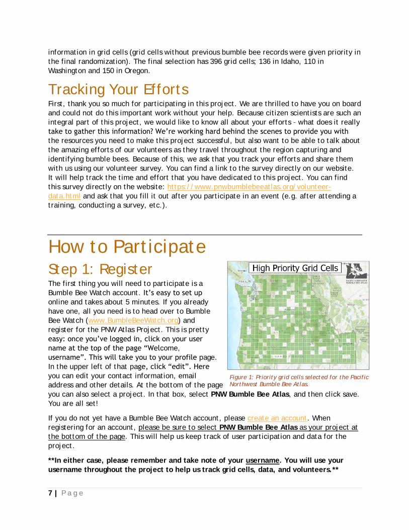
7 | P a g e
information in grid cells (grid cells without previous bumble bee records were given priority in
the final randomization). The final selection has 396 grid cells; 136 in Idaho, 110 in
Washington and 150 in Oregon.
Tracking Your Efforts First, thank you so much for participating in this project. We are thrilled to have you on board
and could not do this important work without your help. Because citizen scientists are such an
integral part of this project, we would like to know all about your efforts – what does it really
take to gather this information? We’re working hard behind the scenes to provide you with
the resources you need to make this project successful, but also want to be able to talk about
the amazing efforts of our volunteers as they travel throughout the region capturing and
identifying bumble bees. Because of this, we ask that you track your efforts and share them
with us using our volunteer survey. You can find a link to the survey directly on our website.
It will help track the time and effort that you have dedicated to this project. You can find
this survey directly on the website: https://www.pnwbumblebeeatlas.org/volunteer-
data.html and ask that you fill it out after you participate in an event (e.g. after attending a
training, conducting a survey, etc.).
How to Participate Step 1: Register The first thing you will need to participate is a
Bumble Bee Watch account. It’s easy to set up
online and takes about 5 minutes. If you already
have one, all you need is to head over to Bumble
Bee Watch (www.BumbleBeeWatch.org) and
register for the PNW Atlas Project. This is pretty
easy: once you’ve logged in, click on your user
name at the top of the page “Welcome,
username”. This will take you to your profile page.
In the upper left of that page, click “edit”. Here
you can edit your contact information, email
address and other details. At the bottom of the page
you can also select a project. In that box, select PNW Bumble Bee Atlas, and then click save.
You are all set!
If you do not yet have a Bumble Bee Watch account, please create an account. When
registering for an account, please be sure to select PNW Bumble Bee Atlas as your project at
the bottom of the page. This will help us keep track of user participation and data for the
project.
**In either case, please remember and take note of your username. You will use your
username throughout the project to help us track grid cells, data, and volunteers.**
Figure 1: Priority grid cells selected for the Pacific Northwest Bumble Bee Atlas.
8 | P a g e
Step 2: Adopt a Grid Cell After you have established a Bumble Bee Watch account and selected a username you can
adopt one or more grid cells. The best way for us to cover the three state area is to recruit
volunteers throughout the region and have them adopt an area (grid cell) to survey (see
survey details below). We have pledged to survey 75% of the grid cells in each state, and need
lots of participants to complete the task! Adopting a grid cell means that you have agreed to
be an integral part of this project, and plan on surveying for bumble bees using our
standardized protocols. This means, at a minimum, you will visit a location within that grid
cell two times year during the bumble bee season and use our standardized protocol to
sample for bumble bees as well as the surrounding habitat. To meet this requirement you can
visit two different location on the same day, or revisit the same location on two different
days.
The best way to adopt a grid cell is online using the project map. That way, you’ll be able to
see which grid cells are already adopted, and which ones need attention. You can find the
information on adopting a grid cell at: www.pnwBumbleBeeAtlas.org.
Step 3: Get Familiar With Training Protocols We will be offering at least five trainings in 2017 (and more in 2018) to help participants learn
how to conduct a survey and participate in the PNW Bumble Bee Atlas. You can find more
information, and register to attend the training on our website:
https://www.pnwbumblebeeatlas.org/events.html.
If you cannot attend a training, we will make as much of the workshop available via
webinar/video as possible. Stay tuned to the website for more details—modules should be
available by late May 2018. Much of the information given in the training will also be included
in this document, but attending an event in person will allow you to connect with other
volunteers, get materials that will help you with the project, ask questions of project
coordinators, and practice survey techniques and identification with bumble bee experts—and
it will be fun!
Step 4: Conduct a Survey Plan your visit Take some time to investigate the grid cell that you’ve adopted. The grid cells are large with
varied habitat, terrain and land ownership. You can survey anywhere in the grid cell for
bumble bees, but taking some time to select potential locations and access routes will
decrease travel time, and maximize the time you can dedicate to bumble bee surveys. We
suggest you start with the project map, or Google Maps (or similar) with aerial photography to
flag potential sites and plan travel routes. Getting familiar with your sites using maps will also
help you when it comes time to submit your data; accurate locations are important! Many
areas of all three states are remote, with limited travel routes – and potentially with limited
cellular service. When surveying, please follow all rules, regulations and posted signs; respect
private property and take all necessary safety precautions. You can find some helpful videos
for this process here: https://www.pnwbumblebeeatlas.org/other-resources.html.
9 | P a g e
It is possible that you will find when you arrive at a pre-selected site that survey conditions
for bumble bees may not be optimal. We encourage folks to be flexible, and opportunistic,
but to stay within their assigned grid cell. As such, bring resources with you to navigate,
including printed maps as cell service is not available in many parts of the Pacific Northwest.
Resources to help you plan your trip (note: we do not guarantee the veracity of any of these
resources, just provide them as tools for you to help plan your trip. These, to our knowledge
are some of the best, and most reliable mapping resources available, though there are
certainly alternatives):
Google Maps with Overlaid Grid (you will be able to find the grid number of your
adopted cell to help you plan a trip)
Idaho Trails Map: trails.idaho.gov
Washington Trails Association: wta.org
Oregon Hikers Trail Guide: oregonhikers.org/field_guide/Main_Page
Green Trails Maps (OR, WA) – available from many outdoor retailers and online
USGS Topo Maps – available from many outdoor retailers and as downloads
DeLorme State Atlas & Gazetteer Paper Maps
Considerations:
Ideally you will survey in an open area with lots of flowers
Unless you have explicit permission from the landowner, stay on public lands and
public rights-of-way (roadsides)
Good choices for surveys – be sure to follow all regulations.
o State Parks
o State Wildlife Areas
o Your Backyard
o U.S. Forest Service land
o BLM land
o Local parks
o National Parks and
Monuments
o National Wildlife Refuges
o Natural Areas
o Your School
o Roadside
National Parks and Monuments, Washington State Parks, and Washington Department
of Natural Resource Natural Areas often have many great locations for bumble bee
surveys, but research in those parks requires a permit. There is no reason you cannot
photograph a bumble bee on a flower in these areas, but you may not capture wildlife
in a net or vial without appropriate research permits. As such, please see incidental
surveys below for surveying in these areas.
Consult with local knowledge about road surfaces and do not always rely on GPS or
Google/Apple Maps for travel planning. Many roads on Forest Service lands are dirt
roads often with logging truck traffic with limited turn around and site distances; they
may also require high clearance vehicles, and additional travel time, please use
caution.
Let someone know your travel plans, including expected return time/date.
10 | P a g e
What to Bring:
Paper Maps
Camera (ideally with macro
capacity) and/or smart phone
Extra batteries and/or charger
Insect net
Data sheets and pencil/pen
Small cooler with ice/ice packs – or
just a bag of ice
Vials or insect viewing jar
Field guides (plant and bumble bee)
Timer
GPS Unit or similar Smartphone App
Hat
Drinking water
Sunscreen
Field notebook
Hand lens
Friends!
Survey Methods Survey Timing and Conditions Bumble bees are generally active from April (or earlier depending on you location) through
September depending on the habitat, species, and weather. Some species may be active
earlier, and some may be active later. But, since the goal of this project is to get a better
understanding of the distribution of all species in Oregon, Washington, and Idaho, we’re
targeting the middle of the season: June, July, and August. In some locations it may be
appropriate to survey earlier, or later than that, but most places will be best June – July.
Bumble bees prefer warm sunny days to forage, and thus these are the best days on which to
conduct surveys. As such, please survey on sunny (or mostly sunny days) between 60°F and
90°F. Conditions much hotter, much cooler and/or much cloudier will likely result in reduced
bumble bee activity. The best sites will be open (not forested) with an abundance and
diversity of flowering resources.
Point Surveys Point surveys are our standard surveys and will provide high quality bumble bee data from any
survey area. These surveys are 45 person minutes and will need to take place in an area
around the size of a hectare (2.5 acres). This means that if you are alone you will survey for
45 minutes. If you brought one friend, you will survey for 22.5 minutes, and if you brought
two friends, you will survey for 15 minutes, etc. You will also need to plan for time to
conduct a habitat assessment on each visit to gather habitat information about the site that
you surveyed and the surrounding area at each site.
Phase 1: Plan your survey area
Surveys should cover approximately one hectare or 2.5 acres (100m x 100m or 328’ x 328’).
This does not have to be a square, but could be 20 m x 500 m along a roadside or any other
similar area configuration. Mark the center of your location on a map (either paper or
smartphone app). This will be very important later for data submission, please document
the location of each survey accurately! See the videos on our website to help you get the
latitude and longitude information. These will need to be in decimal degrees.
https://www.pnwbumblebeeatlas.org/other-resources.html.
11 | P a g e
Phase 2: Fill out the data sheet
This will include date, time, surveyors, location, and basic weather information (approximate
temperature, cloud cover, wind, etc.). See the data sheets for more detail.
Phase 3: Begin your survey
Note the start time of your survey, start the timer and begin searching for bumble bees.
While looking for bumble bees you should wander through the entire survey area, focusing on
plants that are flowering. Focus on ALL flowering plants, not just those that are most
abundant or showy. Because of many reasons different bumble bees are sometimes attracted
to different species of flower. When you find a bumble bee, capture it into a vial (either
directly or using an insect net), note the plant species that it was visiting, and place the vial
in a chilled cooler. I like to put a petal of the flower into each vial to remind me which
species of flower it was visiting when I collate my data later. Alternatively, use a small piece
of paper, a grease pencil etc. to document and connect each bee to its flowering plant. Be
sure to keep bees from different flowers also separated in the cooler so you remember later.
Take a picture of each plant (include flowers and leaves) for later confirmation or
identification. Idaho, Oregon and Washington all have wildflower smartphone apps that can
help you in the field, and there are many other resources available (see
https://www.pnwbumblebeeatlas.org/other-resources.html). Continue in this fashion for 45
person minutes (count only time searching for bumble bees) or until you have run out of vials.
If you run out of vials, stop the timer and continue to Phase 4, and then return to Phase 3 for
the remaining amount of time. When your time is complete, note the end time of your
survey.
Phase 4: Document each bumble bee
After bees are cooled for a period of time (several minutes) they will slow enough to allow
you to photograph them. You can do this using the provided photo chamber, or directly on
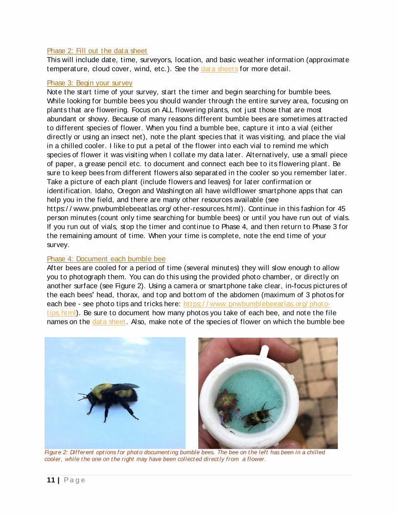
another surface (see Figure 2). Using a camera or smartphone take clear, in-focus pictures of
the each bees’ head, thorax, and top and bottom of the abdomen (maximum of 3 photos for
each bee - see photo tips and tricks here: https://www.pnwbumblebeeatlas.org/photo-
tips.html). Be sure to document how many photos you take of each bee, and note the file
names on the data sheet. Also, make note of the species of flower on which the bumble bee
Figure 2: Different options for photo documenting bumble bees. The bee on the left has been in a chilled cooler, while the one on the right may have been collected directly from a flower.
12 | P a g e
was captured if applicable, or note otherwise (e.g. nest searching, patrolling). After you
photograph the bumble bee it may still be a bit sluggish and may take some time to warm up.
Place in the shade and it will slowly acclimate and be on its way. Continue in this fashion
until you have documented each individual bumble bee. If you have time remaining on your
survey, return to Phase 3, otherwise continue to Phase 5.
Phase 5: Collect Habitat Information
Spend some time walking around your site collecting the data for the Rapid Habitat
Assessment. Take photos of each plant, as well as an overview of the overall habitat.
Phase 6: Complete Documentation
Ensure that all data sheets are complete and that you have collected all necessary habitat
information. While it might be tempting to leave some of this information for later, or when
you get home, taking the time to do it while on site will reduce errors and increase the
quality of the data you collect.
Phase 7: Submit your data
See Steps 5-7 below for assistance. You can also see the guidance on our website:
https://www.pnwbumblebeeatlas.org/help.html
Roadside Surveys Roadside surveys are a common way to document bumble bee abundance and species
richness, and have been used in a standardized way in other regions on the country (MN, VT,
ME). They are also a great way for most anyone to participate, as they often do not require
walking long distances or over uneven terrain. However, roadside surveys are also not perfect
(no method is) as each individual survey is significantly shorter, and our roadsides tend to get
crowded with non-native plants. As one of the goals of this project is to better understand
the needs of our SGCN bumble bees, finding which native plants they are using is a priority.
Roadside surveys may not be a perfect format to learn that specific information, but will still
contribute to our understanding of bumble bee distribution and habitat needs. Roadside
surveys can be conducted en route (or in return) from a formal survey site, or on their own,
but should take place within a grid cell that has been adopted by someone in your party.
Again, be sure to follow posted signs and regulations; please respect private property and if
necessary obtain permission from the landowner.
Phase 1: Plan your route
Select a stretch of road that is at least 10 miles long. Ideally, the stretch of road would have
several obvious open patches when looking at aerial photos/maps. See videos on our website
to help with the planning process: https://www.pnwbumblebeeatlas.org/other-
resources.html.
Phase 2: Begin survey
Once you arrive on your selected route stop at the first patch of available flowers that you
observe (park carefully and follow local regulations and general safety precautions). Observe
the flower patch – if you observe bee activity, begin the survey. If there is no bee activity,
proceed to the next patch of flowers and repeat.
Before you begin the survey, fill out the top of the datasheet (site and weather information).
Be sure to include the start and stop times. A roadside survey is 15 min. long. Start your timer
13 | P a g e
and capture bumble bees into vials. While looking for bumble bees you should wander from
flower patch to flower patch in the roadside area. Focus on ALL flowering plants, not just
those that are most abundant or showy. Because of many reasons, different bumble bees are
sometimes attracted to different species of flower. Be sure to document the species of flower
that each bumble bee was visiting (you can use a small label, a grease pencil, or a sample of
the flower placed in the vial). Place each bee into a chilled cooler.
Phase 3: Record bumble bee data
Once the 15 minute period is over, record each individual bee on the Bumble Bee Survey data
sheet and photo document each individual following the tips here:
https://www.pnwbumblebeeatlas.org/photo-tips.html. Be sure to write the corresponding
photo file names for each individual.
Phase 4: Collect habitat data
Fill out the Rapid Habitat Assessment Form for each roadside stop. Take a picture of each
species of blooming plant, as well as the overall habitat surveyed.
Phase 5: Repeat
Drive at least 1 mile down the road and then find another patch of flowering plants at which
to conduct a survey and go back to Phase 2. Each Roadside survey should consist of five
fifteen minute surveys within a ~10 mile stretch of road.
Phase 6: Submit your data
See Steps 5-7 below. You can also see the guidance on our website:
https://www.pnwbumblebeeatlas.org/help.html
Rapid Habitat Surveys At each location that you conduct a bumble bee survey (Point or Roadside) you will need to
conduct a Rapid Habitat Survey. This information will help us to understand what kinds of
landscape features are important for bumble bees. The habitat survey should take between
10 and 30 minutes to complete. Habitat surveys will be longer for point surveys where each
individual survey area is larger. Each roadside habitat survey will be a bit shorter.
Phase 1: Fill out the site and weather information
Use a GPS device and/or smartphone to gather weather information and locality. If you don’t
have access to weather in the field, you can gather weather from a nearby weather station
later. See https://www.pnwbumblebeeatlas.org/other-resources.html for guidance.
Phase 2: Gather Habitat Information
1. Choose a primary habitat type of the survey area from the list provided, as well as the
habitat types of the surrounding area.
2. Walk the entire survey area and estimate how much of the survey area has blooming
plants.
3. Count the number of blooming species of plants (include trees and shrubs) you
observe.
4. Look for habitat features noted on the datasheet – these are often associated with
bumble bee nesting locations.
5. Do your best to assess the management activities in the area.
14 | P a g e
Phase 3: Document the species of plant in bloom.
Document each species of blooming plant, and include a photo of each.
Phase 4: Submit your data.
See Step 6 below and our website for help with this process.
https://www.pnwbumblebeeatlas.org/other-resources.html
https://www.pnwbumblebeeatlas.org/help.html
Alternative Survey Options Incidental Observations In addition to the formal surveys described above, incidental surveys or bumble bee
observations can also help to our understanding of bumble bee distributions in the Pacific
Northwest. They are more casual, and could occur anywhere, and at any time. These surveys
are also appropriate for National Parks, and other areas where capturing bumble bees without
a permit is prohibited—follow local regulations. You might be in your adopted grid cell, or 100
miles away from it. Nevertheless, and especially now that you have caught the bumble bee
watching bug, you may observe bumble bees visiting flowers and decide to stop and take a
picture. These observations will not take the place of formal surveys, but they will help fill in
information gaps in Oregon, Washington, and Idaho.
Incidental observations/photos can either be in situ (directly on a flower) or in a vial/photo
chamber. Submit only photos that are in-focus with enough detail to determine the species in
the photo (see https://www.pnwbumblebeeatlas.org/photo-tips.html). Please remember that
all observations for the project need to be photo documented to count. Including information
(and a photo if possible) about the plant on which you observed the bee is also very helpful.
Considerations:
With incidental observations, you do not need to submit an observation of every bee
you take at each location. Include only the best photos of each species (but see bullet
point below). If you are not sure if photos are different species or not, error on the
side of including too many observations.
Include observations of the same species of bee visiting different species of flowers –
that is great information to have.
Do your best to identify the species of flower that the bumble bee was visiting. See
https://www.pnwbumblebeeatlas.org/other-resources.html for resources.
If you have a smartphone you can enter these observations directly into Bumble Bee
Watch using the app.
Follow the same rules about location, private property, and general respect for others
experience when collecting incidental observations.
15 | P a g e
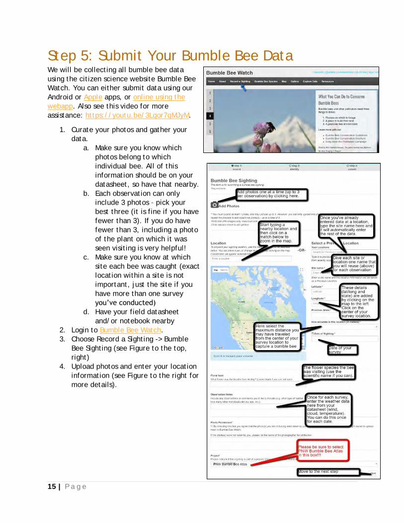
Step 5: Submit Your Bumble Bee Data We will be collecting all bumble bee data
using the citizen science website Bumble Bee
Watch. You can either submit data using our
Android or Apple apps, or online using the
webapp. Also see this video for more
assistance: https://youtu.be/3Lqor7qMJyM.
1. Curate your photos and gather your
data.
a. Make sure you know which
photos belong to which
individual bee. All of this
information should be on your
datasheet, so have that nearby.
b. Each observation can only
include 3 photos – pick your
best three (it is fine if you have
fewer than 3). If you do have
fewer than 3, including a photo
of the plant on which it was
seen visiting is very helpful!
c. Make sure you know at which
site each bee was caught (exact
location within a site is not
important, just the site if you
have more than one survey
you’ve conducted)
d. Have your field datasheet
and/or notebook nearby
2. Login to Bumble Bee Watch.
3. Choose Record a Sighting -> Bumble
Bee Sighting (see Figure to the top,
right)
4. Upload photos and enter your location
information (see Figure to the right for
more details).
16 | P a g e
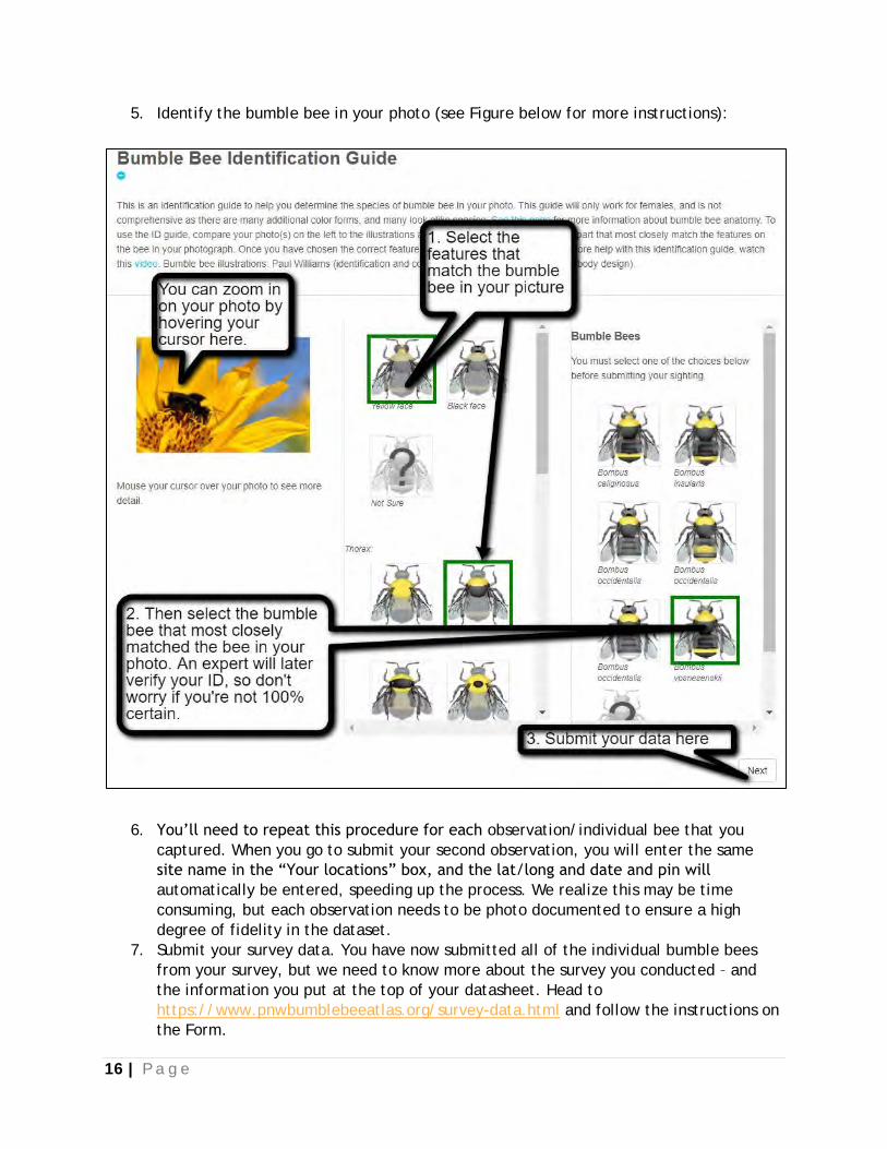
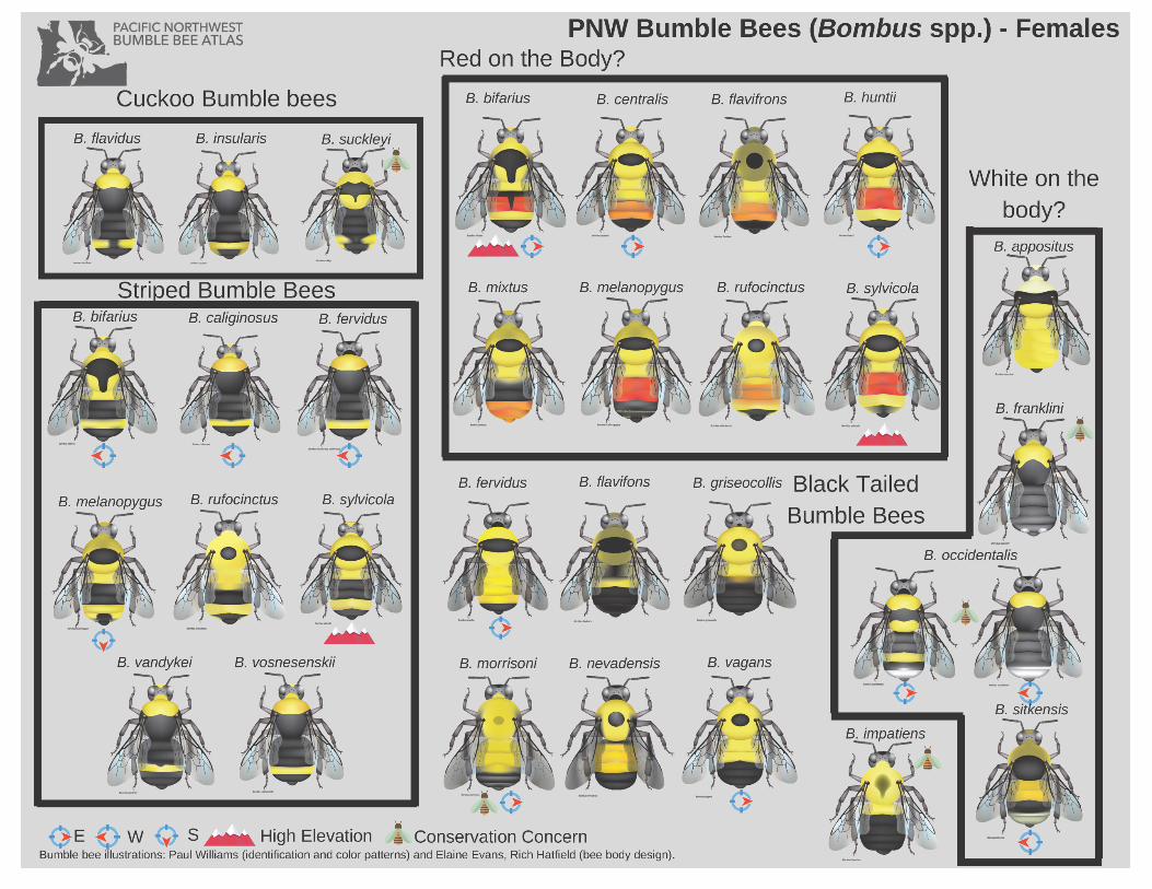
5. Identify the bumble bee in your photo (see Figure below for more instructions):
6. You’ll need to repeat this procedure for each observation/individual bee that you
captured. When you go to submit your second observation, you will enter the same
site name in the “Your locations” box, and the lat/long and date and pin will
automatically be entered, speeding up the process. We realize this may be time
consuming, but each observation needs to be photo documented to ensure a high
degree of fidelity in the dataset.
7. Submit your survey data. You have now submitted all of the individual bumble bees
from your survey, but we need to know more about the survey you conducted – and
the information you put at the top of your datasheet. Head to
https://www.pnwbumblebeeatlas.org/survey-data.html and follow the instructions on
the Form.
17 | P a g e
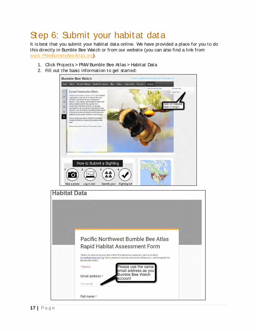
Step 6: Submit your habitat data It is best that you submit your habitat data online. We have provided a place for you to do
this directly in Bumble Bee Watch or from our website (you can also find a link from
www.PNWBumbleBeeAtlas.org).
1. Click Projects > PNW Bumble Bee Atlas > Habitat Data
2. Fill out the basic information to get started:

18 | P a g e
3. Starting on the next page, each field corresponds to a field on your Rapid Habitat
Assessment Form datasheet (See Data Sheets and Field Guides); Note: not all fields are
shown):
4. Proceed to the weather section and then to the habitat section:
19 | P a g e
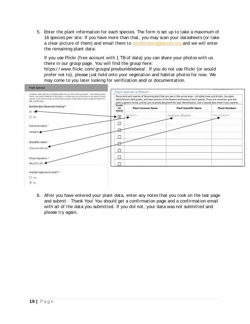
5. Enter the plant information for each species. The form is set up to take a maximum of
16 species per site. If you have more than that, you may scan your datasheets (or take
a clear picture of them) and email them to [email protected] and we will enter
the remaining plant data:
If you use Flickr (free account with 1 TB of data) you can share your photos with us
there in our group page. You will find the group here:
https://www.flickr.com/groups/pnwbumblebees/. If you do not use Flickr (or would
prefer not to), please just hold onto your vegetation and habitat photos for now. We
may come to you later looking for verification and/or documentation.
6. After you have entered your plant data, enter any notes that you took on the last page
and submit – Thank You! You should get a confirmation page and a confirmation email
with all of the data you submitted. If you did not, your data was not submitted and
please try again.
20 | P a g e
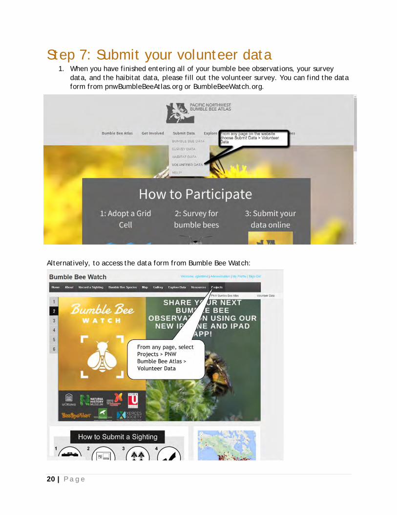
Step 7: Submit your volunteer data 1. When you have finished entering all of your bumble bee observations, your survey
data, and the haibitat data, please fill out the volunteer survey. You can find the data
form from pnwBumbleBeeAtlas.org or BumbleBeeWatch.org.
Alternatively, to access the data form from Bumble Bee Watch:
21 | P a g e
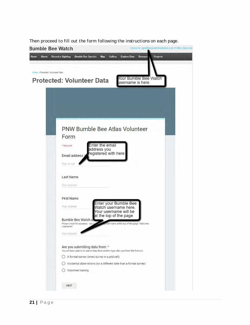
Then proceed to fill out the form following the instructions on each page.
22 | P a g e
Resources Books and Literature:
Droege, S. October 2015. The Very Handy Manual: How to Catch and Identify Bees and Manage
a Collection.
Goulson, D. 2009. Bumblebees: Behaviour, Ecology, and Conservation. Oxford University
Press. 336 pp.
Hatfield R, Jepsen S, Mader E, Black SH, Shepherd M. 2012. Conserving Bumble Bees. Guide-
lines for Creating and Managing Habitat for America’s Declining Pollinators. Available from
http://www.xerces.org/wp-content/uploads/2012/06/conserving_bb.pdf (accessed August
28, 2014).
Koch JB, Strange JP, Williams PH. 2012. Bumble Bees of the Western United States. USDA
Forest Service and the Pollinator Partnership.
Stephen WP. 1957. Bumble bees of western America (Hymenoptera: Apoidea). Corvallis:
Agricultural Experiment Station, Oregon State College.
Thorp RW, Horning DS, Dunning LL. 1983. Bumble bees and cuckoo bumble bees of California
(Hymenoptera, Apidae). University of California Press.
Williams, P.H., R.W. Thorp, L.L. Richardson, S.R. Colla. 2014. Bumble Bees of North America:
An Identification Guide. (Princeton Field Guides). Princeton University Press. 208pp.
Project Websites:
Pacific Northwest Bumble Bee Atlas: pnwBumbleBeeAtlas.org
Idaho Department of Fish and Game: idfg.idaho.gov
The Oregon Bee Project: oregonbeeproject.org
Washington Department of Fish and Wildlife: wdfw.wa.gov
The Xerces Society for Invertebrate Conservation: xerces.org
Other websites:
Google Maps with Overlaid Grid (you will be able to find the grid number of your
adopted cell to help you plan a trip)
Idaho Trails Map: trails.idaho.gov
Washington Trails Association: wta.org
Oregon Hikers Trail Guide: oregonhikers.org/field_guide/Main_Page
Social Media:
Join our Facebook Group: facebook.com/groups/pnwBumbleBeeAtlas/
Our Flickr Group: flickr.com/groups/pnwbumblebees/
Follow us on Twitter: twitter.com/pnwbumblebees
Follow us on Instragram: instagram.com/pnwbumblebees/

23 | P a g e
Data Sheets and Field Guides
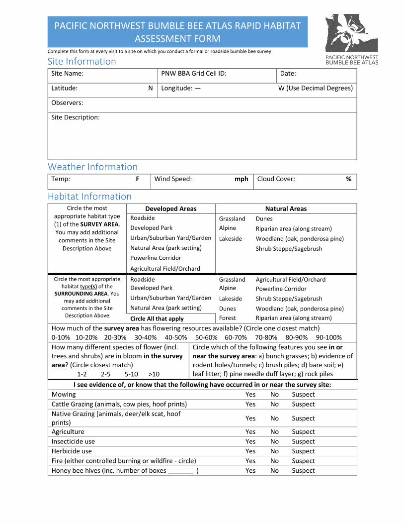
Complete this form at every visit to a site on which you conduct a formal or roadside bumble bee survey
PACIFIC NORTHWEST BUMBLE BEE ATLAS RAPID HABITAT ASSESSMENT FORM
Site Information Site Name: PNW BBA Grid Cell ID: Date:
Latitude: N Longitude: — W (Use Decimal Degrees)
Observers:
Site Description:
Weather Information Temp: F Wind Speed: mph Cloud Cover: %
Habitat Information Circle the most
appropriate habitat type (1) of the SURVEY AREA. You may add additional
comments in the Site Description Above
Developed Areas Natural Areas Roadside Grassland Dunes
Developed Park Alpine Meadow
Riparian area (along stream)
Urban/Suburban Yard/Garden Lakeside Woodland (oak, ponderosa pine)
Natural Area (park setting) Shrub Steppe/Sagebrush
Powerline Corridor
Agricultural Field/Orchard
Circle the most appropriate habitat type(s) of the
SURROUNDING AREA. You may add additional
comments in the Site Description Above
Roadside Grassland Agricultural Field/Orchard
Developed Park Alpine Meadow
Powerline Corridor
Urban/Suburban Yard/Garden Lakeside Shrub Steppe/Sagebrush
Natural Area (park setting) Dunes Woodland (oak, ponderosa pine)
Circle All that apply Forest Riparian area (along stream)
How much of the survey area has flowering resources available? (Circle one closest match) 0-10% 10-20% 20-30% 30-40% 40-50% 50-60% 60-70% 70-80% 80-90% 90-100% How many different species of flower (incl. trees and shrubs) are in bloom in the survey area? (Circle closest match)
Circle which of the following features you see in or near the survey area: a) bunch grasses; b) evidence of rodent holes/tunnels; c) brush piles; d) bare soil; e) leaf litter; f) pine needle duff layer; g) rock piles 1-2 2-5 5-10 >10
I see evidence of, or know that the following have occurred in or near the survey site:
Mowing Yes No Suspect
Cattle Grazing (animals, cow pies, hoof prints) Yes No Suspect
Native Grazing (animals, deer/elk scat, hoof prints)
Yes No Suspect
Agriculture Yes No Suspect
Insecticide use Yes No Suspect
Herbicide use Yes No Suspect
Fire (either controlled burning or wildfire - circle) Yes No Suspect
Honey bee hives (inc. number of boxes _______ ) Yes No Suspect
Complete this form at every visit to a site on which you conduct a formal or roadside bumble bee survey
PACIFIC NORTHWEST BUMBLE BEE ATLAS RAPID HABITAT ASSESSMENT FORM
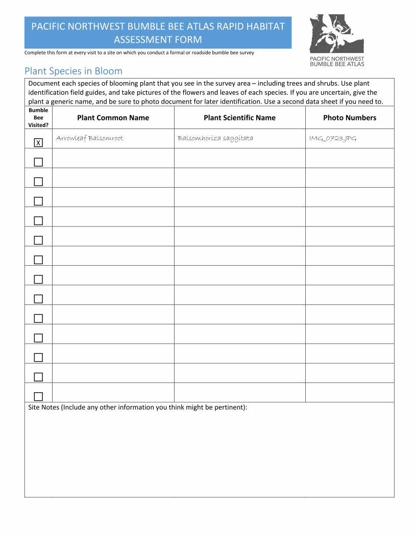
X
Plant Species in Bloom Document each species of blooming plant that you see in the survey area – including trees and shrubs. Use plant identification field guides, and take pictures of the flowers and leaves of each species. If you are uncertain, give the plant a generic name, and be sure to photo document for later identification. Use a second data sheet if you need to. Bumble
Bee Visited?
Plant Common Name Plant Scientific Name Photo Numbers
□ Arrowleaf Balsomroot Balsomhoriza saggitata IMG_0723.JPG
□
□
□
□
□
□
□
□
□
□
□
□
□
Site Notes (Include any other information you think might be pertinent):
Complete this form at every visit to a site on which you conduct a formal or roadside bumble bee survey
PACIFIC NORTHWEST BUMBLE BEE ATLAS RAPID HABITAT ASSESSMENT FORM
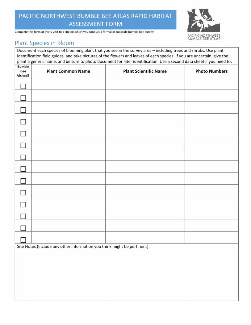
Plant Species in Bloom Document each species of blooming plant that you see in the survey area – including trees and shrubs. Use plant identification field guides, and take pictures of the flowers and leaves of each species. If you are uncertain, give the plant a generic name, and be sure to photo document for later identification. Use a second data sheet if you need to. Bumble
Bee Visited?
Plant Common Name Plant Scientific Name Photo Numbers
□
□
□
□
□
□
□
□
□
□
□
□
□
□
Site Notes (Include any other information you think might be pertinent):
Complete this form at every visit to a site on which you conduct a formal or roadside bumble bee survey
PACIFIC NORTHWEST BUMBLE BEE ATLAS RAPID HABITAT ASSESSMENT FORM
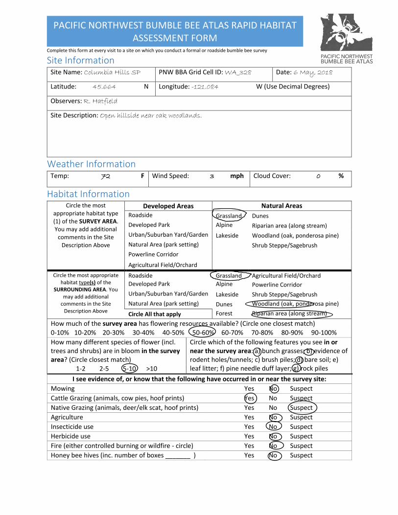
Site Information Site Name: Columbia Hills SP PNW BBA Grid Cell ID: WA_328 Date: 6 May, 2018
Latitude: 45.664 N Longitude: -121.084 W (Use Decimal Degrees)
Observers: R. Hatfield
Site Description: Open hillside near oak woodlands.
Weather Information Temp: 72 F Wind Speed: 3 mph Cloud Cover: 0 %
Habitat Information Circle the most
appropriate habitat type (1) of the SURVEY AREA. You may add additional
comments in the Site Description Above
Developed Areas Natural Areas
Roadside Grassland Dunes
Developed Park Alpine Meadow
Riparian area (along stream)
Urban/Suburban Yard/Garden Lakeside Woodland (oak, ponderosa pine)
Natural Area (park setting) Shrub Steppe/Sagebrush
Powerline Corridor
Agricultural Field/Orchard
Circle the most appropriate habitat type(s) of the
SURROUNDING AREA. You may add additional
comments in the Site Description Above
Roadside Grassland Agricultural Field/Orchard
Developed Park Alpine Meadow
Powerline Corridor
Urban/Suburban Yard/Garden Lakeside Shrub Steppe/Sagebrush
Natural Area (park setting) Dunes Woodland (oak, ponderosa pine)
Circle All that apply Forest Riparian area (along stream)
How much of the survey area has flowering resources available? (Circle one closest match) 0-10% 10-20% 20-30% 30-40% 40-50% 50-60% 60-70% 70-80% 80-90% 90-100% How many different species of flower (incl. trees and shrubs) are in bloom in the survey area? (Circle closest match)
Circle which of the following features you see in or near the survey area: a) bunch grasses; b) evidence of rodent holes/tunnels; c) brush piles; d) bare soil; e) leaf litter; f) pine needle duff layer; g) rock piles 1-2 2-5 5-10 >10
I see evidence of, or know that the following have occurred in or near the survey site:
Mowing Yes No Suspect
Cattle Grazing (animals, cow pies, hoof prints) Yes No Suspect
Native Grazing (animals, deer/elk scat, hoof prints) Yes No Suspect
Agriculture Yes No Suspect
Insecticide use Yes No Suspect
Herbicide use Yes No Suspect
Fire (either controlled burning or wildfire - circle) Yes No Suspect
Honey bee hives (inc. number of boxes _______ ) Yes No Suspect
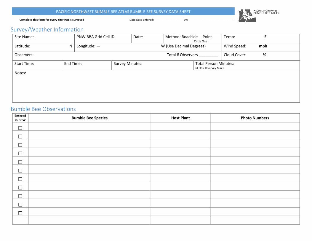
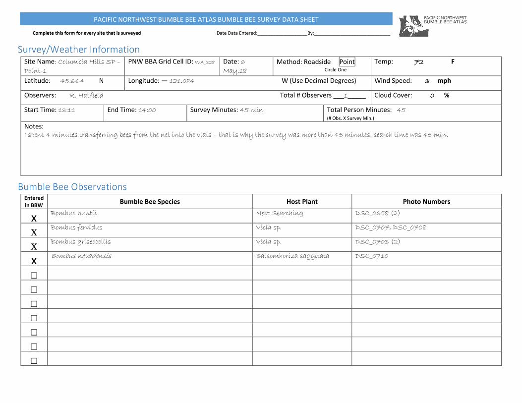
Complete this form for every site that is surveyed Date Data Entered:___________________By:_____________________________
PACIFIC NORTHWEST BUMBLE BEE ATLAS BUMBLE BEE SURVEY DATA SHEET
Survey/Weather Information Site Name: PNW BBA Grid Cell ID: Date: Method: Roadside Point
Circle One
Temp: F
Latitude: N Longitude: — W (Use Decimal Degrees) Wind Speed: mph
Observers: Total # Observers _________ Cloud Cover: %
Start Time: End Time: Survey Minutes: Total Person Minutes: (# Obs. X Survey Min.)
Notes:
Bumble Bee Observations Entered in BBW
Bumble Bee Species Host Plant Photo Numbers
□
□
□
□
□
□
□
□
□
□
□
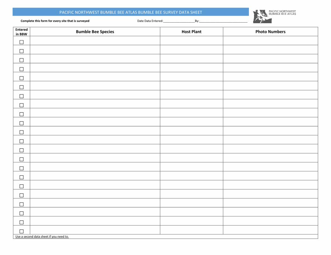
Complete this form for every site that is surveyed Date Data Entered:___________________By:_____________________________
PACIFIC NORTHWEST BUMBLE BEE ATLAS BUMBLE BEE SURVEY DATA SHEET
Entered in BBW
Bumble Bee Species Host Plant Photo Numbers
□
□
□
□
□
□
□
□
□
□
□
□
□
□
□
□
□
□
□
□
□
□
Use a second data sheet if you need to.
Complete this form for every site that is surveyed Date Data Entered:___________________By:_____________________________
PACIFIC NORTHWEST BUMBLE BEE ATLAS BUMBLE BEE SURVEY DATA SHEET
Survey/Weather Information Site Name: Columbia Hills SP –
Point-1 PNW BBA Grid Cell ID: WA_328 Date: 6
May,18 Method: Roadside Point
Circle One
Temp: 72 F
Latitude: 45.664 N Longitude: — 121.084 W (Use Decimal Degrees) Wind Speed: 3 mph
Observers: R. Hatfield Total # Observers ___1_____ Cloud Cover: 0 %
Start Time: 13:11 End Time: 14:00 Survey Minutes: 45 min Total Person Minutes: 45 (# Obs. X Survey Min.)
Notes: I spent 4 minutes transferring bees from the net into the vials – that is why the survey was more than 45 minutes, search time was 45 min.
Bumble Bee Observations Entered in BBW
Bumble Bee Species Host Plant Photo Numbers
x Bombus huntii Nest Searching DSC_0658 (2)
x Bombus fervidus Vicia sp. DSC_0707, DSC_0708
x Bombus griseocollis Vicia sp. DSC_0703 (2)
x Bombus nevadensis Balsomhoriza saggitata DSC_0710
□
□
□
□
□
□
□
Version 1.0, Printed May 2018
pnwBumbleBeeAtlas.org
Supported by: