Embed Size (px)
Citation preview

Part 2:
Spatial and Temporal Data in RDF:
stRDF/stSPARQL and GeoSPARQL
ESWC 2015 Tutorial
Publishing and Interlinking Linked Geospatial Data
Dept. of Informatics and TelecommunicationsNational and Kapodistrian University of Athens

ESWC 2015 Tutorial 2
Common Approach
• The two proposals (stRDF/stSPARQL and GeoSPARQL) offer constructs for:o Developing ontologies for spatial
and temporal data.o Encoding spatial and temporal
data that use these ontologies in RDF.
o Extending SPARQL to query spatial and temporal data.

ESWC 2015 Tutorial 3
Two Proposals
• stRDF/stSPARQL
• GeoSPARQL
ESWC 2015 Tutorial 4
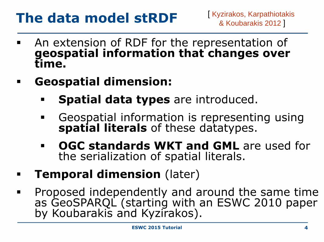
The data model stRDF
An extension of RDF for the representation of geospatial information that changes over time.
Geospatial dimension:
Spatial data types are introduced.
Geospatial information is representing using spatial literals of these datatypes.
OGC standards WKT and GML are used for the serialization of spatial literals.
Temporal dimension (later)
Proposed independently and around the same time as GeoSPARQL (starting with an ESWC 2010 paper by Koubarakis and Kyzirakos).
[ Kyzirakos, Karpathiotakis
& Koubarakis 2012 ]

ESWC 2015 Tutorial 5
strdf:geometry rdf:type rdfs:Datatype;
rdfs:subClassOf rdfs:Literal.
strdf:WKT rdf:type rdfs:Datatype;
rdfs:subClassOf strdf:geometry.
strdf:GML rdf:type rdfs:Datatype;
rdfs:subClassOf strdf:geometry.
Spatial Datatypes

ESWC 2015 Tutorial 6
Example Ontology: Administrative Geography of Greece
Geometry property
strdf:geometry
strdf:GML strdf:WKT

ESWC 2015 Tutorial 7
Example Ontology: Administrative Geography of Greece
strdf:geometry
strdf:GML strdf:WKT
Geometry property

ESWC 2015 Tutorial 8
Example Data in stRDF
gag:Olympia
gag:name "Ancient Olympia";
rdf:type gag:MunicipalCommunity .
Spatial data type
gag:Olympia gag:hasGeometry
"POLYGON((21.5 18.5, 23.5 18.5,
23.5 21, 21.5 21, 21.5 18.5));
<http://www.opengis.net/def/crs/EPSG/0/4326>"^^
strdf:WKT .
Spatial literal
Coordinate Reference
System
Geometry Property

ESWC 2015 Tutorial
gag:Olympia
rdf:type gag:MunicipalCommunity;
gag:name "Ancient Olympia";
gag:population "184"^^xsd:int;
gag:hasGeometry "POLYGON
(((25.37 35.34,…)))"^^strdf:WKT.
gag:OlympiaMUnit
rdf:type gag:MunicipalityUnit;
gag:name "Municipality Unit of
Ancient Olympia".
gag:OlympiaMunicipality
rdf:type gag:Municipality;
gag:name "Municipality of
Ancient Olympia".
gag:Olympia gag:belongsTo gag:OlympiaMUnit .
gag:OlympiaMUnit gag:belongsTo gag:OlympiaMunicipality.
9
Example (cont’d)

ESWC 2015 Tutorial 10
More Examples
Corine Land Use/Land Cover (http://www.eea.europa.eu/publications/COR0-landcover )
Burnt Area Products (project TELEIOS,
http://www.earthobservatory.eu/ )

ESWC 2015 Tutorial 11
Corine Land Use/Land Cover

ESWC 2015 Tutorial 12
Corine Land Use/Land Cover in stRDF(http://www.linkedopendata.gr )
clc:Area_24015134
rdf:type clc:Area ;
clc:hasCode "312"^^xsd:decimal;
clc:hasID "EU-203497"^^xsd:string;
clc:hasArea_ha "255.5807904"^^xsd:double;
clc:hasGeometry "POLYGON((15.53 62.54,
…))"^^strdf:WKT;
clc:hasLandUse clc:ConiferousForest .
Geometry Property

ESWC 2015 Tutorial 13
Burnt Area Products (http://www.earthobservatory.eu/ontologies/noaOntology.owl)

ESWC 2015 Tutorial 14
Burnt Area Products
noa:ba_15
rdf:type noa:BurntArea;
noa:isProducedByProcessingChain
"static thresholds"^^xsd:string;
noa:hasAcquisitionTime
"2010-08-24T13:00:00"^^xsd:dateTime;
noa:hasGeometry "MULTIPOLYGON(((
393801.42 4198827.92, ..., 393008 424131)));
<http://www.opengis.net/def/crs/
EPSG/0/2100>"^^strdf:WKT.
Geometry Property

ESWC 2015 Tutorial 15
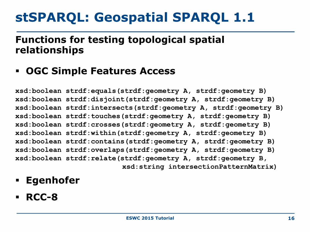
stSPARQL: Geospatial SPARQL 1.1
We define a SPARQL extension function for each function defined in the OpenGIS Simple Features Access standard
Basic functions
Get a property of a geometryxsd:int strdf:dimension(strdf:geometry A)
xsd:string strdf:geometryType(strdf:geometry A)
xsd:int strdf:srid(strdf:geometry A)
Get the desired representation of a geometryxsd:string strdf:asText(strdf:geometry A)
xsd:string strdf:asGML(strdf:geometry A)
Test whether a certain condition holdsxsd:boolean strdf:isEmpty(strdf:geometry A)
xsd:boolean strdf:isSimple(strdf:geometry A)
ESWC 2015 Tutorial 16
stSPARQL: Geospatial SPARQL 1.1
Functions for testing topological spatial relationships
OGC Simple Features Access
xsd:boolean strdf:equals(strdf:geometry A, strdf:geometry B)
xsd:boolean strdf:disjoint(strdf:geometry A, strdf:geometry B)
xsd:boolean strdf:intersects(strdf:geometry A, strdf:geometry B)
xsd:boolean strdf:touches(strdf:geometry A, strdf:geometry B)
xsd:boolean strdf:crosses(strdf:geometry A, strdf:geometry B)
xsd:boolean strdf:within(strdf:geometry A, strdf:geometry B)
xsd:boolean strdf:contains(strdf:geometry A, strdf:geometry B)
xsd:boolean strdf:overlaps(strdf:geometry A, strdf:geometry B)
xsd:boolean strdf:relate(strdf:geometry A, strdf:geometry B,
xsd:string intersectionPatternMatrix)
Egenhofer
RCC-8

ESWC 2015 Tutorial 17
stSPARQL: Geospatial SPARQL 1.1
Spatial analysis functions
Construct new geometric objects from existing geometric objects
strdf:geometry strdf:boundary(strdf:geometry A)
strdf:geometry strdf:envelope(strdf:geometry A)
strdf:geometry strdf:convexHull(strdf:geometry A)
strdf:geometry strdf:intersection(strdf:geometry A, strdf:geometry B)
strdf:geometry strdf:union(strdf:geometry A, strdf:geometry B)
strdf:geometry strdf:difference(strdf:geometry A, strdf:geometry B)
strdf:geometry strdf:symDifference(strdf:geometry A, strdf:geometry B)
strdf:geometry strdf:buffer(strdf:geometry A, xsd:double distance, xsd:anyURI units)
Spatial metric functions
xsd:float strdf:distance(strdf:geometry A, strdf:geometry B, xsd:anyURI units)
xsd:float strdf:area(strdf:geometry A)
Spatial aggregate functions
strdf:geometry strdf:union(set of strdf:geometry A)
strdf:geometry strdf:intersection(set of strdf:geometry A)
strdf:geometry strdf:extent(set of strdf:geometry A)

ESWC 2015 Tutorial 18
stSPARQL: Geospatial SPARQL 1.1
Select clause
Construction of new geometries (e.g., strdf:buffer(?geo, 0.1, uom:metre))
Spatial aggregate functions (e.g., strdf:union(?geo))
Metric functions (e.g., strdf:area(?geo))
Filter clause
Functions for testing topological spatial relationships between spatial terms (e.g.,
strdf:contains(?G1, strdf:union(?G2, ?G3)))
Numeric expressions involving spatial metric functions
(e.g., strdf:area(?G1) ≤ 2*strdf:area(?G2)+1)
Boolean combinations
Having clause
Boolean expressions involving spatial aggregate functions and spatial metric
functions or functions testing for topological relationships between spatial terms
(e.g., strdf:area(strdf:union(?geo))>1)

ESWC 2015 Tutorial 19
stSPARQL: An example (1/3)
SELECT ?name
WHERE {
?comm rdf:type gag:LocalCommunity;
gag:name ?name;
gag:hasGeometry ?commGeo .
?ba rdf:type noa:BurntArea;
noa:hasGeometry ?baGeo .
FILTER(strdf:overlaps(?commGeo,?baGeo))
}Spatial
Function
Return the names of local communities that have been affected by fires

ESWC 2015 Tutorial 20
stSPARQL: An example (2/3)
SELECT ?ba ?baGeom
WHERE {
?r rdf:type clc:Region;
clc:hasGeometry ?rGeom;
clc:hasCorineLandUse ?f.
?f rdfs:subClassOf clc:Forest.
?c rdf:type gag:LocalCommunity;
gag:hasGeometry ?cGeom.
?ba rdf:type noa:BurntArea;
noa:hasGeometry ?baGeom.
FILTER( strdf:intersects(?rGeom,?baGeom) &&
strdf:distance(?baGeom,?cGeom,uom:metre) < 200)}
Spatial Functions
Find all burnt forests near local communities

ESWC 2015 Tutorial
Spatial Function
21
SELECT ?burntArea
(strdf:intersection(?baGeom,
strdf:union(?fGeom))
AS ?burntForest)
WHERE {
?burntArea rdf:type noa:BurntArea;
noa:hasGeometry ?baGeom.
?forest rdf:type clc:Region;
clc:hasLandCover clc:ConiferousForest;
clc:hasGeometry ?fGeom.
FILTER(strdf:intersects(?baGeom,?fGeom))
}
GROUP BY ?burntArea ?baGeom
Compute the parts of burnt areas that lie in coniferous forests.
stSPARQL: An example (3/3)
Spatial Aggregate
ESWC 2015 Tutorial
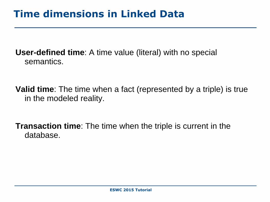
Time dimensions in Linked Data
User-defined time: A time value (literal) with no special semantics.
Valid time: The time when a fact (represented by a triple) is true in the modeled reality.
Transaction time: The time when the triple is current in the database.

ESWC 2015 Tutorial
The time dimension of stRDF: The valid time of triples
The following extensions are introduced in stRDF:• Timeline: the (discrete) value space of the datatype xsd:dateTime of
XML-Schema
• Two kinds of time primitives are supported: time instants and time periods.• A time instant is an element of the time line.
• A time period is an expression of the form [B, E) or [B, E] or (B, E] or (B, E) where B and E
are time instants called the beginning and ending time of the period.
• The new datatype strdf:period is introduced.
23
rdfs:Literal
strdf:WKT strdf:GML
strdf:periodstrdf:geometry

ESWC 2015 Tutorial
The time dimension of stRDF (cont’d)
• Triples are extended to quads.
• A temporal triple (quad) is an expression of the form s p o t.
where s p o. is an RDF triple and t is a time instant or time
period called the valid time of the triple.
• The temporal constants NOW and UC (“until changed”) are
introduced.
24

ESWC 2015 Tutorial
An example with valid time
25
Forest

ESWC 2015 Tutorial 26
Forest
clc:region1 clc:hasLandCover clc:Forest
"[2006-08-25T11:00:00+02, "UC")"^^strdf:period .
An example with valid time

ESWC 2015 Tutorial
An example with valid time
27
Forest
clc:region1 clc:hasLandCover clc:Forest
"[2006-08-25T11:00:00+02, "UC")"^^strdf:period .
Burnt area

ESWC 2015 Tutorial 28
Forest Burnt area
noa:ba1 rdf:type noa:BurntArea
"[2007-08-25T11:00:00+02, "UC")"^^strdf:period .
clc:region1 clc:hasLandCover clc:Forest
"[2006-08-25T11:00:00+02, "UC")"^^strdf:period .
An example with valid time

ESWC 2015 Tutorial 29
Forest Burnt area
noa:ba1 rdf:type noa:BurntArea
"[2007-08-25T11:00:00+02, "UC"))"^^strdf:period .
clc:region1 clc:hasLandCover clc:Forest
"[2006-08-25T11:00:00+02,2007-08-25T11:00:00+02)"^^strdf:period .
An example with valid time

ESWC 2015 Tutorial 30
Forest Burnt area Agricultural area
clc:region1 clc:hasLandCover clc:AgriculturalArea
"[2009-08-25T11:00:00+02, "UC")"^^strdf:period .
noa:ba1 rdf:type noa:BurntArea
"[2007-08-25T11:00:00+02,2009-08-25T11:00:00+02)"^^strdf:period .
clc:region1 clc:hasLandCover clc:Forest
"[2006-08-25T11:00:00+02,2007-08-25T11:00:00+02)"^^strdf:period .
An example with valid time

ESWC 2015 Tutorial
The time dimension of stSPARQL
The following extensions are introduced:
• Triple patterns are extended to quad patterns (the last component is a temporal
term: variable or constant)
• Temporal extension functions are introduced:
• Allen's temporal relations (e.g., strdf:after)
• Period constructors (e.g., strdf:period_intersect)
• Temporal aggregates (e.g., strdf:maximalPeriod)
31
ESWC 2015 Tutorial
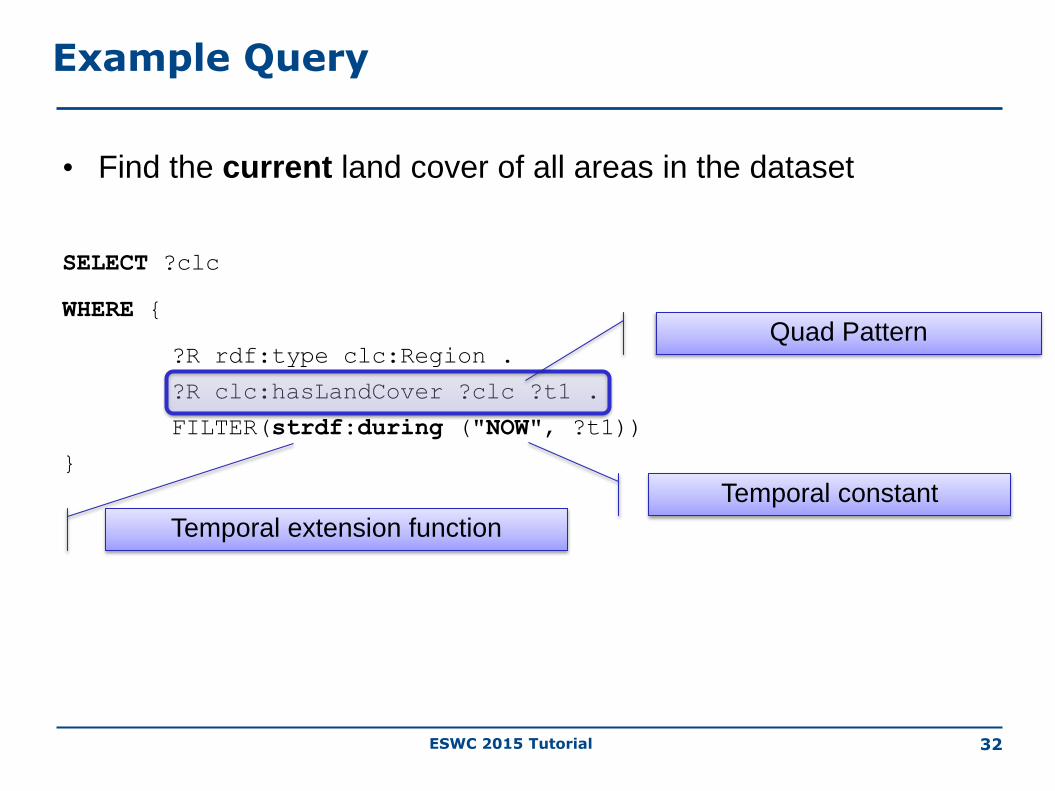
• Find the current land cover of all areas in the dataset
SELECT ?clc
WHERE {
?R rdf:type clc:Region .
?R clc:hasLandCover ?clc ?t1 .
FILTER(strdf:during ("NOW", ?t1))
}
Temporal extension function
Temporal constant
Example Query
32
Quad Pattern

ESWC 2015 Tutorial 33
Two Proposals
• stRDF/stSPARQL
• GeoSPARQL

ESWC 2015 Tutorial 34
GeoSPARQL
GeoSPARQL is an OGC standard.
Functionalities similar to stRDF/stSPARQL:
Geometries are represented using literals of spatial datatypes.
Literals are serialized using WKT and GML.
The same families of functions are offered for querying geometries.
Functionalities beyond stSPARQL:
High level ontologies inspired from GIS terminology.
Topological relations can now be asserted as well so that reasoning and querying on them is possible.
A query rewriting mechanism.
Functionalities of stSPARQL that are not included in GeoSPARQL:
• Geospatial aggregate functions
• Temporal dimension

ESWC 2015 Tutorial
GeoSPARQL Components
Core
Topology VocabularyExtension
- relation family
Geometry Extension- serialization- version
Geometry TopologyExtension
- serialization- version - relation family
Query RewriteExtension
- serialization- version - relation family
RDFS Entailment Extension
- serialization- version - relation family
Parameters
• Serialization
• WKT
• GML
• Relation Family
• Simple Features
• RCC-8
• Egenhofer

ESWC 2015 Tutorial 36
GeoSPARQL Core
Defines two top level classes that can be used to organize geospatial data.

ESWC 2015 Tutorial 37
GeoSPARQL Geometry Extension
Provides vocabulary for asserting and querying data about the geometric attributes of a feature.

ESWC 2015 Tutorial 38
Example Ontology: Greek Administrative Geography
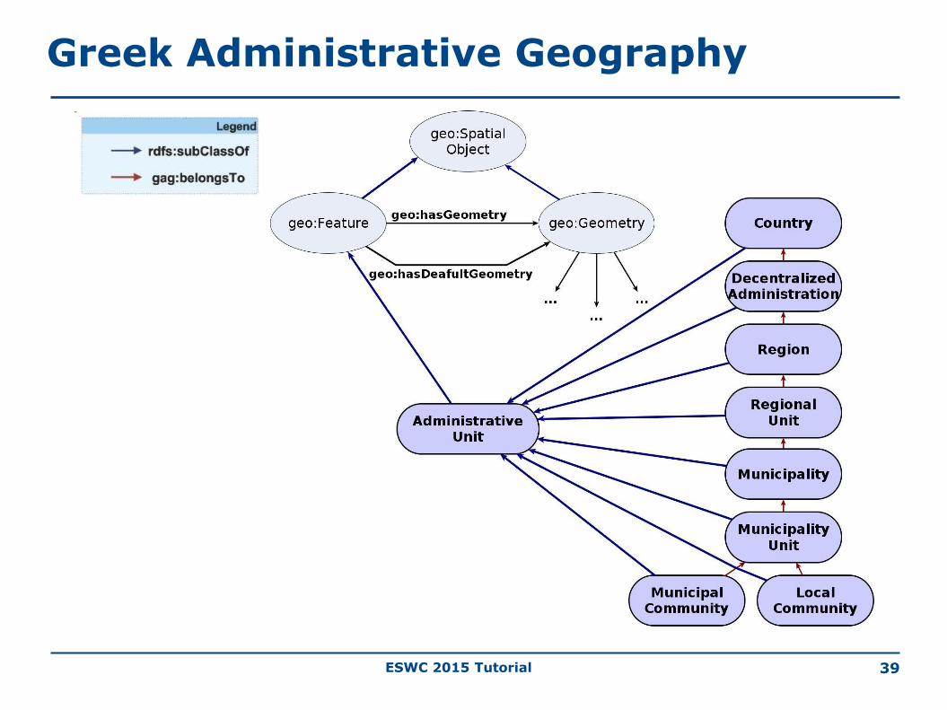
ESWC 2015 Tutorial 39
Greek Administrative Geography

ESWC 2015 Tutorial 40
Greek Administrative Geography

ESWC 2015 Tutorial 41
Example Data
gag:Olympia
rdf:type gag:MunicipalCommunity;
gag:name "Ancient Olympia";
gag:population "184"^^xsd:int;
geo:hasGeometry ex:polygon1.
ex:polygon1
rdf:type geo:Geometry;
geo:asWKT "http://www.opengis.net/def/crs/OGC/1.3/CRS84
POLYGON((21.5 18.5,23.5 18.5,
23.5 21,21.5 21,21.5 18.5))"
^^sf:wktLiteral.
Datatype from Geometry extension
Geometry literal
Property from Geometry extension
Property from Geometry extension
Class from Geometry extension

ESWC 2015 Tutorial 42
Non-Topological Query Functions of the Geometry Extension
The following non-topological query functions are also offered:
geof:distance
geof:buffer
geof:convexHull
geof:intersection
geof:union
geof:difference
geof:symDifference
geof:envelope
geof:boundary
ESWC 2015 Tutorial 43
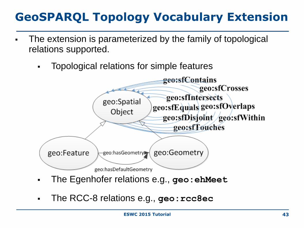
GeoSPARQL Topology Vocabulary Extension
The extension is parameterized by the family of topological relations supported.
Topological relations for simple features
The Egenhofer relations e.g., geo:ehMeet
The RCC-8 relations e.g., geo:rcc8ec

ESWC 2015 Tutorial
gag:Olympia
rdf:type gag:MunicipalCommunity;
gag:name "Ancient Olympia".
gag:OlympiaMUnit
rdf:type gag:MunicipalityUnit;
gag:name "Municipality Unit of
Ancient Olympia".
gag:OlympiaMunicipality
rdf:type gag:Municipality;
gag:name "Municipality of
Ancient Olympia".
gag:Olympia geo:sfWithin gag:OlympiaMUnit .
gag:OlympiaMUnit geo:sfWithin gag:OlympiaMunicipality.
44
Greek Administrative Geography
Simple Features topological
relation

ESWC 2015 Tutorial 45
GeoSPARQL: An example
SELECT ?m
WHERE {
?m rdf:type gag:MunicipalityUnit.
?m geo:sfContains gag:Olympia.
}
Find the municipality unit that contains the community of Ancient Olympia
Simple Featurestopological relation
Answer: ?m = gag:OlympiaMUnit

ESWC 2015 Tutorial 46
GeoSPARQL: An example
SELECT ?m
WHERE {
?m rdf:type gag:Municipality.
?m geo:sfContains gag:Olympia.
}
Find the municipality that contains the community of Ancient Olympia
Answer?

ESWC 2015 Tutorial 47
Example (cont’d)
The answer to the previous query is
?m = gag:OlympiaMunicipality
GeoSPARQL does not tell you how to compute this answer which needs reasoning about the transitivity of relation geo:sfContains.
Options: • Use rules• Use constraint-based techniques

ESWC 2015 Tutorial 48
The Geometry Topology Extension
• Offers vocabulary for querying topological properties of geometry literals.
• Simple Features• geof:relate
• geof:sfEquals
• geof:sfDisjoint
• geof:sfIntersects
• geof:sfTouches
• geof:sfCrosses
• geof:sfWithin
• geof:sfContains
• geof:sfOverlaps
• Egenhofer (e.g., geof:ehDisjoint)• RCC-8 (e.g., geof:rcc8dc)

ESWC 2015 Tutorial 49
Example Query
SELECT ?name
WHERE {
?comm rdf:type gag:LocalCommunity;
gag:name ?name;
geo:hasGeometry ?commGeo .
?ba rdf:type noa:BurntArea;
geo:hasGeometry ?baGeo .
FILTER(geof:sfOverlaps(?commGeo,?baGeo))
}Geometry Topology Extension Function
Return the names of local communities that have been affected by fires
Geometry Extension Property
Geometry Extension Property

ESWC 2015 Tutorial 50
GeoSPARQL Query Rewrite Extension
Provides a collection of RIF rules that use topological extension functions to establish the existence of topological predicates.
Example: given the RIF rule named geor:sfWithin, the serializations of the geometries of gag:Athens and gag:Greece named AthensWKT and GreeceWKT and the fact that
geof:sfWithin(AthensWKT, GreeceWKT)
returns true from the computation of the two geometries, we can derive the triple
gag:Athens geo:sfWithin gag:Greece
One possible implementation is to re-write a given SPARQL query.

ESWC 2015 Tutorial 51
RIF Rule
Forall ?f1 ?f2 ?g1 ?g2 ?g1Serial ?g2Serial
(?f1[geo:sfWithin->?f2] :-
Or(
And (?f1[geo:hasDefaultGeometry->?g1]
?f2[geo:hasDefaultGeometry->?g2]
?g1[ogc:asGeomLiteral->?g1Serial]
?g2[ogc:asGeomLiteral->?g2Serial]
External(geof:sfWithin (?g1Serial,?g2Serial)))
And (?f1[geo:hasDefaultGeometry->?g1]
?g1[ogc:asGeomLiteral->?g1Serial]
?f2[ogc:asGeomLiteral->?g2Serial]
External(geof:sfWithin (?g1Serial,?g2Serial)))
And (?f2[geo:hasDefaultGeometry->?g2]
?f1[ogc:asGeomLiteral->?g1Serial]
?g2[ogc:asGeomLiteral->?g2Serial]
External(geof:sfWithin (?g1Serial,?g2Serial)))
And (?f1[ogc:asGeomLiteral->?g1Serial]
?f2[ogc:asGeomLiteral->?g2Serial]
External(geof:sfWithin (?g1Serial,?g2Serial)))
))
Feature-
Feature
Feature-
Geometry
Geometry-
Feature
Geometry-
Geometry

ESWC 2015 Tutorial 52
Example
SELECT ?feature
WHERE {
?feature geo:sfWithin
geonames:OlympiaMunicipality.
}
Find all features that are inside the municipality of Ancient Olympia

ESWC 2015 Tutorial 53
Rewritten Query
SELECT ?feature
WHERE { {?feature geo:sfWithin geonames:Olympia }
UNION
{ ?feature geo:hasDefaultGeometry ?featureGeom .
?featureGeom geo:asWKT ?featureSerial .
geonames:Olympia geo:hasDefaultGeometry ?olGeom .
?olGeom geo:asWKT ?olSerial .
FILTER (geof:sfWithin (?featureSerial, ?olSerial)) }
UNION { ?feature geo:hasDefaultGeometry ?featureGeom .
?featureGeom geo:asWKT ?featureSerial .
geonames:Olympia geo:asWKT ?olSerial .
FILTER (geof:sfWithin (?featureSerial, ?olSerial)) }
UNION { ?feature geo:asWKT ?featureSerial .
geonames:Olympia geo:hasDefaultGeometry ?olGeom .
?olGeom geo:asWKT ?olSerial .
FILTER (geof:sfWithin (?featureSerial, ?olSerial)) }
UNION {
?feature geo:asWKT ?featureSerial .
geonames:Olympia geo:asWKT ?olSerial .
FILTER (geof:sfWithin (?featureSerial, ?olSerial)) }

ESWC 2015 Tutorial
Specifies the RDFS entailments that follow from the class and property hierarchies defined in the other components e.g., the Geometry Extension.
Systems should use an implementation of RDFS entailment to allow the derivation of new triples from those already in a graph.
54
GeoSPARQL RDFS Entailment Extension

ESWC 2015 Tutorial 55
Example
Given the triples
ex:f1 geo:hasGeometry ex:g1 .
geo:hasGeometry rdfs:domain geo:Feature.
we can infer the following triples:
ex:f1 rdf:type geo:Feature .
ex:f1 rdf:type geo:SpatialObject .

ESWC 2015 Tutorial
Readings
56
• Material from the Strabon web site (http://strabon.di.uoa.gr ).
• The following tutorial paper which introduces to the topic of linked geospatial data:M. Koubarakis, M. Karpathiotakis, K. Kyzirakos, C. Nikolaou and M. Sioutis. Data Models and Query Languages for Linked Geospatial Data. Reasoning Web Summer School 2012.http://strabon.di.uoa.gr/files/survey.pdf
• The following paper which introduces stSPARQL and Strabon:K. Kyzirakos, M. Karpathiotakis and M. Koubarakis. Strabon: A Semantic Geospatial DBMS. 11th International Semantic Web Conference (ISWC 2012). November 11-15, 2012. Boston, USA.http://iswc2012.semanticweb.org/sites/default/files/76490289.pdf
• The following paper which introduces the temporal features of stSPARQL and Strabon:
K. Bereta, P. Smeros and M. Koubarakis. Representing and Querying the Valid Time of Triples for Linked Geospatial Data. In the 10th Extended Semantic Web Conference (ESWC 2013). Montpellier, France. May 26-30, 2013.http://www.strabon.di.uoa.gr/files/eswc2013.pdf
• The GeoSPARQL standard found at http://www.opengeospatial.org/standards/geosparql

ESWC 2015 Tutorial
Readings (cont’d)
57
• The following paper which introduces the RDFi framework:Charalampos Nikolaou and Manolis Koubarakis. Incomplete Information in RDF. In the 7th International Conference on Web Reasoning and Rule Systems (RR 2013). Mannheim, Germany. July 27-29, 2013.http://cgi.di.uoa.gr/~koubarak/publications/rr2013.pdf
• The following paper which introduces the benchmark Geographica:G. Garbis, K. Kyzirakos and M. Koubarakis. Geographica: A Benchmark for Geospatial RDF Stores. In the 12th International Semantic Web Conference (ISWC 2013). Sydney, Australia. October 21-25, 2013.http://cgi.di.uoa.gr/~koubarak/publications/Geographica.pdf
![Ontology inference using spatial and trajectory domain … · an RDF data store. ... urban planning [5], route optimization [17] and traffic monitor- ... temporal and spatio-temporal](https://img.pdfslide.us/doc/110x75/5b8a67517f8b9a655f8e39d1/ontology-inference-using-spatial-and-trajectory-domain-an-rdf-data-store-.jpg)