Embed Size (px)
Citation preview

Part 1 Base Information
1. Project Title SH 42 Conceptual Design Plan for the Reconfiguration of SH 42: Including Highway Access Control, Multimodal and Intersection improvements
2. Project Start/End points or Geographic Area Provide a map with submittal, as appropriate
SH 42 from Empire Road/Lock Street to SH 7/Arapahoe Road (Map, Attachment 1)
3. Project Sponsor (entity that will
construct/ complete and be financially responsible for the project)
City of Louisville
4. Project Contact Person, Title, Phone Number, and Email
Megan Davis, Deputy City Manager, 303-335-4539, [email protected]
5. Does this project touch CDOT Right-of-Way, involve a CDOT roadway, access RTD property, or request RTD involvement to operate service?
X Yes No
If yes, provide applicable concurrence documentation with submittal (Concurrence approval, Attachment 2)
6. What planning document(s) identifies this project?
X DRCOG 2040 Fiscally Constrained Regional Transportation Plan (2040 FCRTP)
SH 42 is within the DRCOG FCRTP road network. It is identified as an unfunded vision project for additional lanes. It is also identified as a potential regional corridor for 2040 MV rapid transit system expansion.
X Local plan:
SH 42 Gateway Plan
SH 7 PEL 75th St. to SH 287
https://assets.bouldercounty.org/wp-content/uploads/2018/04/SH7-PEL-Final-Report-Appendix-A-Corridor-Conditions.pdf
RTD NAMS Study
https://www.dropbox.com/s/1uj1mt3z1h80ya4/Final%20Report%20508%5B1%5D.pdf?dl=0
Other(s): Provide link to document/s and referenced page number if possible, or provide documentation with submittal
7. Identify the project’s key elements.
Rapid Transit Capacity (2040 FCRTP)
X Transit Other: Transit Priority Lanes
X Bicycle Facility
X Pedestrian Facility
X Safety Improvements
X Roadway Capacity or Managed Lanes (2040 FCRTP)
X Roadway Operational
Grade Separation
Roadway
Railway
Bicycle
Pedestrian
Roadway Pavement Reconstruction/Rehab
Bridge Replace/Reconstruct/Rehab
X Study
Design
Other:
8. Problem Statement What specific Metro Vision-related regional problem/issue will the transportation project
address?
SH 42 is considered a principal arterial in the 2040 FCRTP. The corridor spans from Louisville to Lafayette, and has high vehicle volume with current cars per day (ADT) of 22,600 and DRCOG projections for 2040 ADT of 28,000. According to DRCOG data, population and employment densities along the route are anticipated to continue to grow from 2010 to 2040. This corridor has been identified in the DRCOG MVRTP as one of the key congested corridors in 2016. Economic and population growth in the area has contributed to increased traffic volumes, as well as increased demand for multimodal facilities to accommodate walking, bicycling and transit. Developments that accommodate vulnerable populations, including two senior living facilities and affordable housing for families and individuals with disabilities has also been developed along the corridor.
In terms of functionality, SH 42 has only two lanes, and with more than 20,000 ADT turning vehicles often cause delays. The highway operates at a LOS F according to the Highway Capacity Manual. Travel times along SH 42 between South Boulder Road and the Northwest Parkway were measured and demonstrated considerable delays. (Attachment 3) The major intersections along SH 42 experience high crash rates, with 59 crashes, 14 resulting in injury, occurring at the intersection of SH 7 and SH 42 between 2010 – 2014 (Source: SH 7 PEL 75th St. to SH 287), and 63 crash occurrences at SH 42 and South Boulder Road between 2013 - 2015. A pedestrian fatality occurred in 2017 at SH 42 and Hecla Drive.
The local communities of Louisville and Lafayette have identified the need to improve the overall design and use of the corridor in order to improve safety and reliability, provide consistent, continuous multimodal facilities for walking and biking, improve transit access, and reduce traffic congestion.
The proposed plan will provide design for improvements that address transportation, growth and land development challenges outlined in the DRCOG Metro Vision plan, including: increasing mobility options for individuals without a car or with mobility challenges, reducing traffic congestion, reducing traffic crashes and improving overall safety, and addressing access issues related to population and economic growth and development along this corridor.
9. Define the scope and specific elements of the project. The project scope is to complete a conceptual design plan for the SH 42 corridor that would include the following elements:
Review of current corridor plans and reconfigure vehicle and multimodal use within the existing corridor. The City of Louisville completed a SH 42 Gateway Corridor Plan in 2013 (The Gateway Plan), and a Transportation Master Plan for the city is currently underway. Many of the recommendations have been implemented from the Gateway Plan, including the installation of traffic signals and medians in some areas. However, current input and analysis gathered as a part of the City’s 2019 Transportation Master Plan, a 2018 traffic volume measurement, and updated forecasts suggest that the SH 42 Gateway Corridor Plan may not have provided optimal solutions to address several competing goals throughout the corridor. The study was completed before the regional RTD transit study – Northwest Area Mobility Study (NAMS) – and while the Gateway Plan contemplated transit, it does not include the final NAMS recommendations for enhanced transit along SH 42. In addition, several of the access recommendations on SH 42 were included based upon a secondary road network that will not be installed, and further analysis with updated utilization data has demonstrated that some of the access recommendations will cause more significant travel delays on SH 42 than originally identified. Further, the Gateway Plan proposed 3 lane configuration of SH 42 through Louisville does not meet future capacity needs or maximize the use of the corridor for transit and multimodal use in a safe manner.
Improve multimodal connectivity throughout the entire corridor. There is currently no contiguous bike lane, sidewalk, path or walkway that extends SH 42 between Empire Road in Louisville to Arapahoe Road in Lafayette. Sidewalks exist along various sections of the road, and shoulder width varies throughout. With increased density and commercial development in the area, more residents of both communities are seeking alternate modes to reach amenities such as parks, trails, grocery stores, shopping and other services. Many commuters use the corridor, and with the implementation of BRT on SH 7 from Boulder to Brighton and eventual connection to enhanced transit on SH 42, even more employees coming into Louisville and Lafayette will utilize the SH 42 corridor. This plan will provide a conceptual design for a concrete, separated bicycle/pedestrian path along SH 42
for this entire stretch, and consider necessary pedestrian crossings associated with the bike/ped path at all intersections.
Intersection improvements at key locations, including SH 42 and South Boulder Road, Baseline Road and SH 7/Arapahoe Road. The City of Louisville Transportation Master Plan has made recommendations for intersection improvements at SH 42 and South Boulder Road, which need to be prioritized/agreed upon by the community and conceptually designed. Recent improvements and reconfiguration of the Baseline and SH 42 intersection has been completed, but no facilities for bicycle/pedestrian improvements have been included. Once a bike/ped trail alignment is identified, some improvements will be necessary at this crossing to accommodate alternate modes. The intersection of SH 7 and SH 42 is a high priority due to the ongoing planning of the SH 7 BRT project. Intersection improvements are needed in this area, and will need to be consistent with the recommendations of the SH 7 BRT PEL.
Consideration/accommodation of future side access points. The City of Louisville is mostly built-out in these areas, but there will be some additional development along SH 42 in the coming years, including the Coal Creek Station Development southwest of the South Boulder Road and SH 42 intersection that could require changes to access onto SH 42. The City of Lafayette has planned developments between Pascal Drive (the boundary between the two communities) and Baseline Road that will necessitate additional access onto SH 42, as well as one signal that is planned at Indian Peaks Trail and SH 42. The City of Louisville has planned signals at Short Street and Hecla Drive. Hecla Drive has not been approved by CDOT, but is necessary to serve the growth and special populations in that area. The infrastructure for these signals and accesses are either currently in design or will be designed as a part of future development, but they must be considered in the overall conceptual design of the SH 42 corridor.
Consideration/accommodation of future enhanced transit within the SH 42 corridor. The 2014 NAMS study included a proposal for enhanced transit along the SH 42 corridor. The potential transit line would provide a north-south connection from Lafayette and Louisville to the US 36 US 36 Flatiron Flyer BRT. The study recognized that with limited right of way and narrow shoulder widths, exclusive lane opportunities for BRT would not be feasible along SH 42. However, with no transit currently available along SH 42, this plan will allow the communities to design infrastructure that could support future transit, including the enhanced transit conceptualized through NAMS.
10. What is the status of the proposed project? The two jurisdictions are at various stages of planning for projects along the corridor. The City of Louisville has high-level conceptual design for some aspects of the portion of SH 42 between Empire Road and Paschal Drive, and has completed design for the intersection improvements at Short Street and Hecla Street. Louisville has been meeting with Boulder County Open Space and has a conceptual alignment identified for the bike/ped path along SH 42 between Empire Road and South Boulder Road, but no designs at this time. In addition, the City’s Transportation Master Plan (scheduled to be completed this summer) will include conceptual design for a 5 lane configuration of SH 42 between Empire and Paschal. (Attachment 4) The City of Lafayette has done little to no planning for the portion of SH 42 from Paschal Drive to SH 7. Some geometric and signal improvements have been made at SH 42 and Baseline Road, and the SH 7 PEL has provided an analysis of existing traffic conditions, safety analysis, transit infrastructure and cursory resource and environmental analysis in the SH 7/SH 42/96th St intersection. This plan will bring both entities up to the same level of planning with regard to future plans for SH 42.
11. Would a smaller federal funding amount than requested be acceptable, while maintaining the original intent of the project?
Yes X No
If yes, define smaller meaningful limits, size, service level, phases, or scopes, along with the cost for each.
A. Project Financial Information and Funding Request

1. Total Project Cost $500,000
2. Total amount of DRCOG Subregional Share Funding Request (no greater than $20 million and not to exceed 50% of the total project cost) $350,000 70%
of total project cost
3. Outside Funding Partners (other than DRCOG Subregional Share funds) List each funding partner and contribution amount.
$$ Contribution Amount
% of Contribution to Overall Total
Project Cost
City of Louisville $75,000 15%
City of Lafayette $75,000 15%
Total amount of funding provided by other funding partners (private, local, state, Subregion, or federal)
$150,000 30%
Funding Breakdown (year by year)*
*The proposed funding plan is not guaranteed if the project is selected for funding. While DRCOG will do everything it can to accommodate the applicants’ request, final funding will be assigned at DRCOG’s discretion within fiscal constraint. Funding amounts must be provided in year of expenditure dollars using an inflation factor of 3% per year from 2018.
FY 2020 FY 2021 FY 2022 FY 2023 Total
Federal Funds (Subregional)
$350,000 $0 $0 $ $350,000
State Funds $0 $0 $0 $ $
Local Funds $150,000 $ $0 $ $150,000
Total Funding $500,000 $ $0 $ $500,000
4. Phase to be Initiated
Choose from Design, ENV, ROW, CON, Study, Service, Equip. Purchase, Other
Design
5. By checking this box, the applicant’s Chief Elected Official (Mayor or County Commission Chair) or City/County Manager for local governments or Agency Director or equivalent for others, has certified it allows this project request to be submitted for DRCOG-allocated funding and will follow all DRCOG policies and state and federal regulations when completing this project, if funded.
Part 2 Evaluation Criteria, Questions, and Scoring
A. Regional significance of proposed project WEIGHT 40% Provide qualitative and quantitative (derived from Part 3 of the application) responses to the following questions on the regional significance of the proposed project.
1. Why is this project regionally important?
SH 42 is an important regional arterial identified in the DRCOG Metro Vision plan. The corridor directly serves the communities of Louisville and Lafayette, as well as Superior, Broomfield and many parts of unincorporated Boulder County. In addition, many people in the metro region employed in Southeast Boulder County utilize the corridor to access work.
The City of Louisville expects to see a 28% increase in employment growth by 2040 (over 2015 employment levels), with most of the growth occurring in the northern and downtown portions of the City (Attachment 5). The City’s current commuting patterns indicate that 93% of the people who work in Louisville commute from other places, with 45% in-commuting from the US 36 corridor. The highest density of Louisville employees live in Superior, Broomfield, Thornton and Westminster. SH 42 is the primary corridor for people coming into Louisville to work every day. Likewise, Lafayette sees 45% of its workforce commuting in by way of US 36. With more corridors offering access into Lafayette from US 36, including 287, not all but some of these commuters would be utilizing SH 42. Louisville has a high share of living wage jobs as compared with the Boulder County or the Denver Metro regional average, so the area provides well-paying jobs which attract a diverse workforce from the broader region.
2. Does the proposed project cross and/or benefit multiple municipalities? If yes, which ones and how?
Yes, this project travels through the Cities of Louisville and Lafayette, as well as Open Space lands jointly owned by the Cities and Boulder County. It will directly benefit the Cities of Louisville and Lafayette, and provide benefit to the broader region by planning improvements to the SH 42 corridor. The plan will design facility improvements that will reduce traffic delays, improved safety, particularly for vulnerable populations, and increased bicycle and pedestrian use. The terminal point of the study and the SH 42 corridor to the north is SH 7, which is a critical east-west corridor serving Boulder and Adams County, and is currently under consideration for future BRT implementation. When the BRT is completed, the connection of the SH 42 corridor and future transit on this corridor will be important for riders connecting to Lafayette and Louisville.
3. Does the proposed project cross and/or benefit another subregion(s)? If yes, which ones and how? Yes. On the south/east end, SH 42 connects to SH 287, serving as a primary corridor linking the City and County of Broomfield to Louisville and Lafayette. In addition, traffic studies illustrating commuting patterns to Louisville’s Technology Center (CTC) have demonstrated a significant amount of in-commuting from US 36 east of the Broomfield interchange, with vehicles exiting US 36 at the Northwest Parkway/Interlocken loop, travelling north to 96th Street onto SH 42 in Louisville. Traffic speeds decrease and wait times increase once vehicles reach SH 42 at 96th Street. This project will create a plan to address the needs in this corridor, which will impact transportation users into and beyond the Boulder County and Broomfield County subregions. As described above, the SH 42 connection to SH 7 will be important in connecting to the west and east.
4. How will the proposed project address the specific transportation problem described in the Problem Statement
(as submitted in Part 1, #8)?
This project will address several transportation problems by creating a conceptual design plan for future projects along SH 42. The plan will address the increased demand for multimodal pedestrian and bicycle transportation options by identifying an alignment and design for a cohesive, comprehensive multimodal facility along the SH 42 corridor. The plan will seek to reduce safety concerns at major intersections and all along the SH 42 corridor by separating multimodal uses, improving intersection geometrics and improving the road configurations. The plan will address the current and future congestion and travel time delays by creating a plan to reconfigure the use of the corridor and right of way, including the accommodation of transit. And, the plan will address future/anticipated access demands by Louisville and Lafayette along the corridor.
5. One foundation of a sustainable and resilient economy is physical infrastructure and transportation. How will the
completed project allow people and businesses to thrive and prosper? There has been significant economic growth in this corridor. SH 42 was previously a rural highway, with little development and economic activity throughout. While the Cities have preserved much of this rural character by purchasing open spaces along the corridor (jointly between Boulder County, City of Louisville and City of Lafayette), several areas along the corridor have been developed or are in various stages of planning for development. The core section of the SH 42 in Louisville includes several existing and anticipated access points that support economic prosperity of the area that is directly adjacent to Louisville’s downtown area (directly to the west of SH 42, including the Downtown East Louisville redevelopment or “DELO” area). There is a sports complex just east of downtown (east of SH 42) which serves as an economic draw for visitors to the community. Just north of South Boulder Road, significant residential and commercial development has occurred and it has become increasingly important for this portion of the community to have multimodal connections to economic activity, including the Louisville downtown and the SH 42 North areas. For Lafayette, there are several commercial and residential developments planned along SH 42 north of Paschal Drive (which serves as the border of Louisville and Lafayette), and the corridor will see more economic opportunity within the next five years. This plan will design transportation infrastructure that supports a sustainable transportation network surrounding SH 42, allowing for regional traffic to effectively move through the corridor and accommodate the access needs of the communities living within the corridor.
6. How will connectivity to different travel modes be improved by the proposed project? This project will provide connectivity for bicycles and pedestrians where no contiguous connectivity exists. In addition, there is currently no transit service along SH 42 (except a small leg of the 228, but with no stops on SH 42). The NAMS study included a proposal for enhanced transit along SH 42, and one of the goals of this plan will be to design roadway improvements that would accommodate future transit service.
7. Describe funding and/or project partnerships (other subregions, regional agencies, municipalities, private, etc.)
established in association with this project. The project is a direct partnership between the Cities of Louisville, Lafayette and CDOT. The Cities will each contribute funding for the study, and intend to work together to identify conceptual designs that provide consistency for various travel modes throughout the entire corridor. Our communities have a long history of successful collaboration and partnership, as evidenced by our joint open space purchases in this corridor and our regional trail successes. Letters of support in Attachment 6
B. DRCOG Board-approved Metro Vision TIP Focus Areas WEIGHT 30% Provide qualitative and quantitative (derived from Part 3 of the application) responses to the following questions on how the proposed project addresses the three DRCOG Board-approved Focus Areas (in bold).
1. Describe how the project will improve mobility infrastructure and services for vulnerable populations (including improved transportation access to health services).
Over the past ten years, the SH 42 corridor in Louisville has grown significantly. There are approximately 1,100 new dwelling units in this part of Louisville, including the Boulder County Housing Authority Kestrel development, the Foundry (approved but not yet constructed), Coal Creek Station (approved but not yet constructed), Steel Ranch, Steel Ranch South, Lanterns, Balfour, and North End. This increased development has changed the conditions and character of the corridor from rural to more urban/suburban. This development has resulted in increased vehicle traffic generated from within the region, as well as increased pedestrian traffic throughout the area.
Together, these residential communities result in one of Louisville’s highest density areas of vulnerable populations, including persons over 65 year of age, minority persons, low-income households, linguistically-challenged persons, individuals with disabilities, households without a motor vehicle and children ages 6 – 17.
Within a mile of this corridor (center of the corridor) there are nearly 4,000 persons over age 65, 2,260 minority persons, 384 linguistically challenged persons, 2,718 people with disabilities and 4,958 children between the age of 6 – 17. There are 2,163 low-income households and 529 households without a car. This represents a high proportion of residents in Louisville and Lafayette that are considered vulnerable and potentially mobility challenged. This corridor is an important transportation connector in their lives.
The Boulder County Housing Authority (BCHA) Kestrel development at SH 42 and Hecla Drive includes a unique population of people with mobility challenges: Of the 341 total residents 128 (37%) are seniors 55 and older, and 60 (18%) have a disability (that qualifies them for federal housing for disabled individuals). Another 86 residents under 18 also live in the development. Many of the residents don’t have cars and rely on public transit and/or walking to access employment, food and other basic needs, activities and amenities. A recent car count indicated that there are fewer than 200 vehicles owned within the community.
The Balfour Senior Living Louisville Campus is located east of SH 42 on Hecla Drive, across the street from the Kestrel community. This Balfour campus is comprised of more than 400 residents averaging 85 years of age. The majority of residents reside less than .3 mile from the intersection of SH 42 and Hecla Dr. and are of an age that mandates managing canes, walkers, wheelchairs, or motorized scooters for their walking mobility.
For many of the residents in both of these areas, the nearest healthcare amenities are located 1.6 miles due east on South Boulder Road at the new Clinica Family Health Services (the FQHC clinic serving southeast Boulder County). However, while there is bus service along South Boulder Road, the mobility access to get from Kestrel to the bus stop on SBR requires travel along SH 42, and pedestrian facilities are not easily accessible or don’t exist along the entire corridor.
2. Describe how the project will increase reliability of existing multimodal transportation network.
Multimodal travel on SH 42 is currently dangerous and uninviting due to lack of infrastructure, especially during the AM and PM peak hours, when commuter traffic is heavy coming into Louisville and Lafayette. With no current continuous bicycle and pedestrian facility, and heavy traffic along the highway, this travel corridor for modes other than a vehicle is not a viable option. Estimated bicycle use on SH 42 in Louisville is currently approximately 10 cyclists per day. Based on comperable multi-use trail utilization in other parts of the City (Coal Creek regional trail segments and Boulder to Longmont trail segments), we would expect an estimated 250 daily users on the trail. This would reduce the vehicle usage, particularily for short trips (less than 3 miles) which make up 31% of all trips within, to or from Louisville. Further, no transit exists within the corridor. The proposed plan would increase the reliability by establishing multimodal transportation options where they currently are not in existance or possible.
3. Describe how the project will improve transportation safety and security.
The plan will provide for at-grade separated bike and pedestrian facilities that will provide safety for multimodal uses on this heavily traveled corridor. This approach will provide a safety improvement for vehicles and pedestrians/cyclists alike. In addition, the plan will address the current configuration for vehicles along the entire corridor, the safe installation of access improvements, and safety improvements at intersections.
C. Consistency & Contributions to Transportation-focused Metro Vision Objectives
WEIGHT 20%
Provide qualitative and quantitative responses (derived from Part 3 of the application) to the following items on how the proposed project contributes to Transportation-focused Objectives (in bold) in the adopted Metro Vision plan. Refer to the expanded Metro Vision Objective by clicking on links.
MV objective 2 Contain urban development in locations designated for urban growth and services.
1. Will this project help focus and facilitate future growth in locations where urban-level infrastructure already exists or areas where plans for infrastructure and service expansion are in place? In Louisville portions of the corridor are nearing build-out, however there are a few planned developments remaining. In Lafayette, there is also some additional development planned and approved along the corridor. This plan will consider this development and planned access points, and also influence infrastructure and service expansions to serve this growth.
X Yes No
MV objective 3 Increase housing and employment in urban centers.
2. Will this project help establish a network of clear and direct multimodal connections within and between urban centers, or other key destinations?
X Yes No
One of the goals of this project is to create a clear and continuous multimodal connection within the SH 42 corridor. There are urban centers throughout this corridor in both Louisville and Lafayette, including residential, commercial, retail and office as well as many amenities such as the Louisville Sports Complex and Indian Peaks Golf Course. With 28,000 ADT, the busy nature of the corridor makes it difficult for pedestrians and bicycles to travel safety and comfortably. The multimodal connections developed through this plan will provide alternate modes of travel for people living in the corridor.
MV objective 4 Improve or expand the region’s multimodal transportation system, services, and connections.
3. Will this project help increase mobility choices within and beyond the region for people, goods, or services?
X Yes No
This project will increase the capacity of this multimodal regional roadway, SH 42. It will provide additional mobility choices within the SH 42 corridor by creating conceptual design plans for biking, walking and for transit.
MV objective 6a Improve air quality and reduce greenhouse gas emissions.
4. Will this project help reduce ground-level ozone, greenhouse gas emissions, carbon monoxide, particulate matter, or other air pollutants?
X Yes No
The plan will identify multimodal improvements that will support a shift in uses to alternate modes. The estimated reduction in GHG emissions is 162 lbs. Since this state highway runs directly through the Cities of Louisville and Lafayette, this will result in reductions in particulate matter, improving local air quality.
MV objective 7b Connect people to natural resource or recreational areas.
5. Will this project help complete missing links in the regional trail and greenways network or improve other multimodal connections that increase accessibility to our region’s open space assets?
X Yes No
There are many regional trails and open spaces within the SH 42 corridor. The Highline trail connects trail systems
within Louisville and Lafayette and, an underpass is planned for construction just north of Hecla Drive to support this
connection. The Cities have made significant investments in open space and trails along SH 42 – many of them joint
purchases that enhance the greenways and preserve open spaces and agricultural heritage along the corridor. The
Harney-Lastoka property, located on SH 42 in Louisville includes trails, an organic garden stand, and ball fields. The
multimodal connections along SH 42 will provide increased accessibility to all of these assets.
MV objective 10 Increase access to amenities that support healthy, active choices.
6. Will this project expand opportunities for residents to lead healthy and active lifestyles? X Yes No
By providing 2 miles of contiguous multi-use pathway along SH 42, there will be expanded opportunities for walking and bicycling instead of driving. Currently there is not a shoulder stretching this span of SH 42, nor is there a bike lane, so bikes do not utilize this corridor. This plan will provide multimodal improvements that will support cyclists commuting on SH 42.
MV objective 13 Improve access to opportunity.
7. Will this project help reduce critical health, education, income, and opportunity disparities by promoting reliable transportation connections to key destinations and other amenities?
X Yes No
With no transit opportunities along SH 42, and limited facilities to support pedestrian mobility, this plan will increase the ability for vulnerable populations to access jobs, education, and health services. Connections to Louisville and Lafayette downtown areas, and other job centers lie along the corridor. Expanding transit along the corridor will provide linkages to the existing service network, reaching the broader region for these opportunities and services.
MV objective 14 Improve the region’s competitive position.
8. Will this project help support and contribute to the growth of the region’s economic health and vitality?
X Yes No
SH 42 is a key corridor to the Cities of Louisville and Lafayette, as well as the broader region. This plan will help ensure the region remains competitive by improving the multimodal transportation facilities that businesses depend on for local, regional and global customers. The plan represents a coordinated local and regional effort to planning.
D. Project Leveraging WEIGHT 10%
9. What percent of outside funding sources (non-DRCOG-allocated Regional Share funding) does this project have?
80%+ outside funding sources ........... High 60-79% ......................................... Medium 59% and below .................................... Low

Part 3 Project Data Worksheet – Calculations and Estimates (Complete all subsections applicable to the project)
A. Transit Use
1. Current ridership weekday boardings
2. Population and Employment
Year Population within 1 mile Employment within 1 mile Total Pop and Employ within 1 mile
2020
2040
Transit Use Calculations Year
of Opening 2040
Weekday Estimate 3. Enter estimated additional daily transit boardings after project is
completed. (Using 50% growth above year of opening for 2040 value, unless justified) Provide supporting documentation as part of application submittal
4. Enter number of the additional transit boardings (from #3 above) that were previously using a different transit route. (Example: {#3 X 25%} or other percent, if justified)
5. Enter number of the new transit boardings (from #3 above) that were previously using other non-SOV modes (walk, bicycle, HOV, etc.) (Example: {#3 X 25%} or other percent, if justified)
6. = Number of SOV one-way trips reduced per day (#3 – #4 – #5)
7. Enter the value of {#6 x 9 miles}. (= the VMT reduced per day) (Values other than the default 9 miles must be justified by sponsor; e.g., 15 miles for regional service or 6 miles for local service)
8. = Number of pounds GHG emissions reduced (#7 x 0.95 lbs.)
9. If values would be distinctly greater for weekends, describe the magnitude of difference:
10. If different values other than the suggested are used, please explain here:
B. Bicycle Use
1. Current weekday bicyclists 10
2. Population and Employment
Year Population within 1 mile Employment within 1 mile Total Pop and Employ within 1 mile
2020 21969 9917 31886
2040 23623 10663 34286
Bicycle Use Calculations Year
of Opening 2040
Weekday Estimate
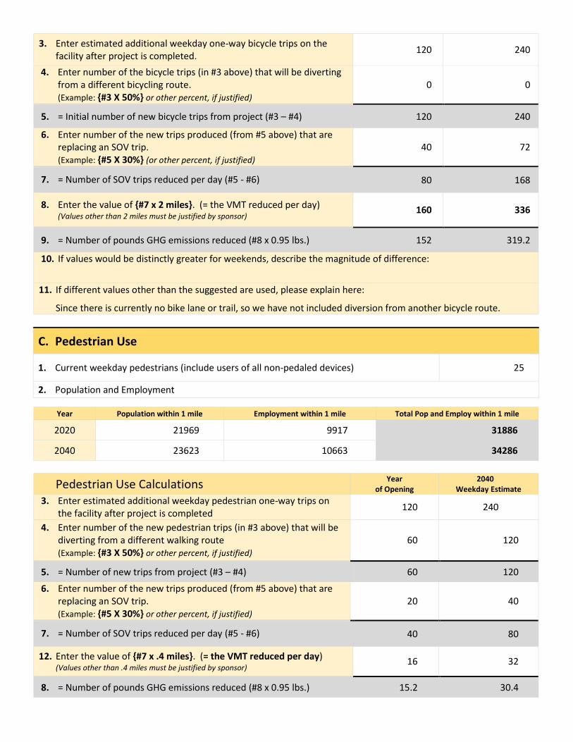
3. Enter estimated additional weekday one-way bicycle trips on the facility after project is completed.
120 240
4. Enter number of the bicycle trips (in #3 above) that will be diverting from a different bicycling route. (Example: {#3 X 50%} or other percent, if justified)
0 0
5. = Initial number of new bicycle trips from project (#3 – #4) 120 240
6. Enter number of the new trips produced (from #5 above) that are replacing an SOV trip. (Example: {#5 X 30%} (or other percent, if justified)
40 72
7. = Number of SOV trips reduced per day (#5 - #6)
80 168
8. Enter the value of {#7 x 2 miles}. (= the VMT reduced per day) (Values other than 2 miles must be justified by sponsor)
160 336
9. = Number of pounds GHG emissions reduced (#8 x 0.95 lbs.) 152 319.2
10. If values would be distinctly greater for weekends, describe the magnitude of difference:
11. If different values other than the suggested are used, please explain here:
Since there is currently no bike lane or trail, so we have not included diversion from another bicycle route.
C. Pedestrian Use
1. Current weekday pedestrians (include users of all non-pedaled devices) 25
2. Population and Employment
Year Population within 1 mile Employment within 1 mile Total Pop and Employ within 1 mile
2020 21969 9917 31886
2040 23623 10663 34286
Pedestrian Use Calculations Year
of Opening 2040
Weekday Estimate 3. Enter estimated additional weekday pedestrian one-way trips on
the facility after project is completed 120 240
4. Enter number of the new pedestrian trips (in #3 above) that will be diverting from a different walking route (Example: {#3 X 50%} or other percent, if justified)
60 120
5. = Number of new trips from project (#3 – #4) 60 120
6. Enter number of the new trips produced (from #5 above) that are replacing an SOV trip. (Example: {#5 X 30%} or other percent, if justified)
20 40
7. = Number of SOV trips reduced per day (#5 - #6)
40 80
12. Enter the value of {#7 x .4 miles}. (= the VMT reduced per day) (Values other than .4 miles must be justified by sponsor)
16 32
8. = Number of pounds GHG emissions reduced (#8 x 0.95 lbs.) 15.2 30.4
9. If values would be distinctly greater for weekends, describe the magnitude of difference:
10. If different values other than the suggested are used, please explain here:
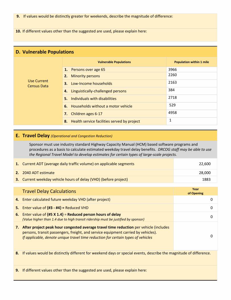
D. Vulnerable Populations
Use Current Census Data
Vulnerable Populations Population within 1 mile
1. Persons over age 65 3966
2. Minority persons 2260
3. Low-Income households 2163
4. Linguistically-challenged persons 384
5. Individuals with disabilities 2718
6. Households without a motor vehicle 529
7. Children ages 6-17 4958
8. Health service facilities served by project 1
E. Travel Delay (Operational and Congestion Reduction)
Sponsor must use industry standard Highway Capacity Manual (HCM) based software programs and procedures as a basis to calculate estimated weekday travel delay benefits. DRCOG staff may be able to use the Regional Travel Model to develop estimates for certain types of large-scale projects.
1. Current ADT (average daily traffic volume) on applicable segments 22,600
2. 2040 ADT estimate 28,000
3. Current weekday vehicle hours of delay (VHD) (before project) 1883
Travel Delay Calculations Year
of Opening
4. Enter calculated future weekday VHD (after project) 0
5. Enter value of {#3 - #4} = Reduced VHD 0
6. Enter value of {#5 X 1.4} = Reduced person hours of delay (Value higher than 1.4 due to high transit ridership must be justified by sponsor)
0
7. After project peak hour congested average travel time reduction per vehicle (includes persons, transit passengers, freight, and service equipment carried by vehicles). If applicable, denote unique travel time reduction for certain types of vehicles
0
8. If values would be distinctly different for weekend days or special events, describe the magnitude of difference.
9. If different values other than the suggested are used, please explain here:
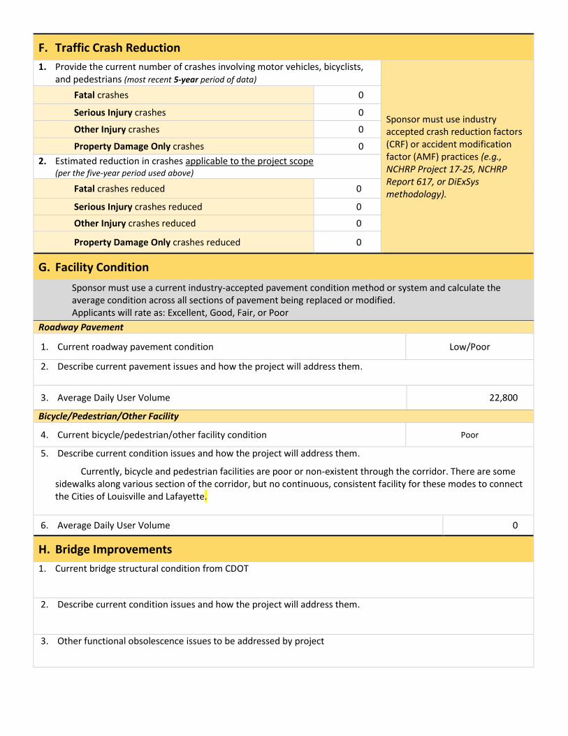
F. Traffic Crash Reduction
1. Provide the current number of crashes involving motor vehicles, bicyclists, and pedestrians (most recent 5-year period of data)
Sponsor must use industry accepted crash reduction factors (CRF) or accident modification factor (AMF) practices (e.g., NCHRP Project 17-25, NCHRP Report 617, or DiExSys methodology).
Fatal crashes 0
Serious Injury crashes 0
Other Injury crashes 0
Property Damage Only crashes 0
2. Estimated reduction in crashes applicable to the project scope (per the five-year period used above)
Fatal crashes reduced 0
Serious Injury crashes reduced 0
Other Injury crashes reduced 0
Property Damage Only crashes reduced 0
G. Facility Condition
Sponsor must use a current industry-accepted pavement condition method or system and calculate the average condition across all sections of pavement being replaced or modified. Applicants will rate as: Excellent, Good, Fair, or Poor
Roadway Pavement
1. Current roadway pavement condition Low/Poor
2. Describe current pavement issues and how the project will address them.
3. Average Daily User Volume 22,800
Bicycle/Pedestrian/Other Facility
4. Current bicycle/pedestrian/other facility condition Poor
5. Describe current condition issues and how the project will address them.
Currently, bicycle and pedestrian facilities are poor or non-existent through the corridor. There are some sidewalks along various section of the corridor, but no continuous, consistent facility for these modes to connect the Cities of Louisville and Lafayette.
6. Average Daily User Volume 0
H. Bridge Improvements
1. Current bridge structural condition from CDOT
2. Describe current condition issues and how the project will address them.
3. Other functional obsolescence issues to be addressed by project
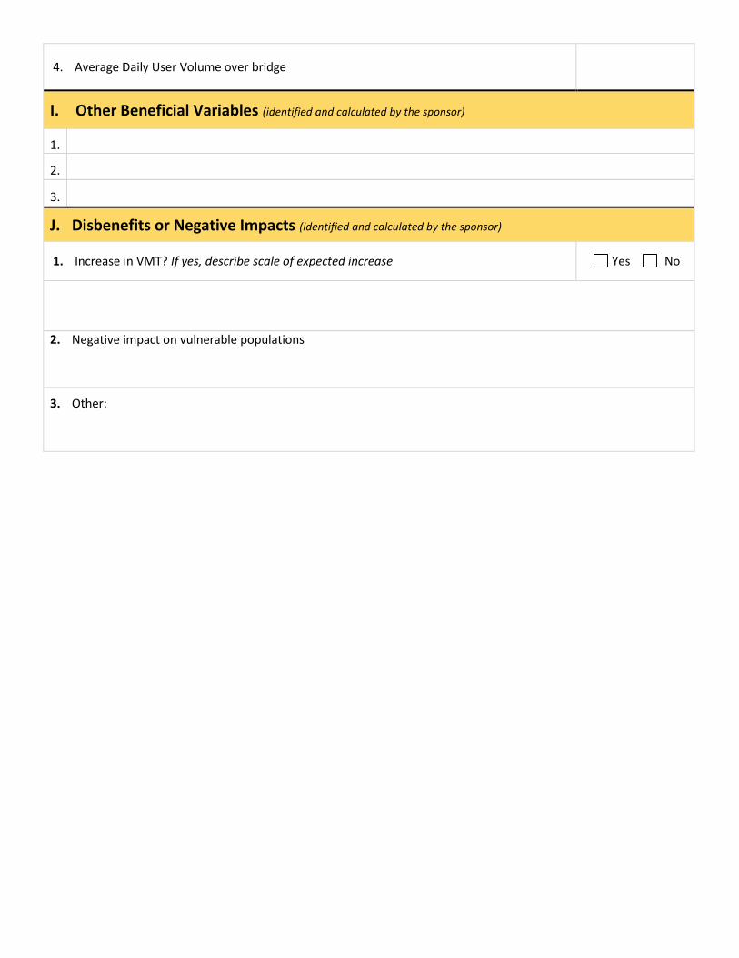
4. Average Daily User Volume over bridge
I. Other Beneficial Variables (identified and calculated by the sponsor)
1.
2.
3.
J. Disbenefits or Negative Impacts (identified and calculated by the sponsor)
1. Increase in VMT? If yes, describe scale of expected increase Yes No
2. Negative impact on vulnerable populations
3. Other: