Embed Size (px)
Citation preview
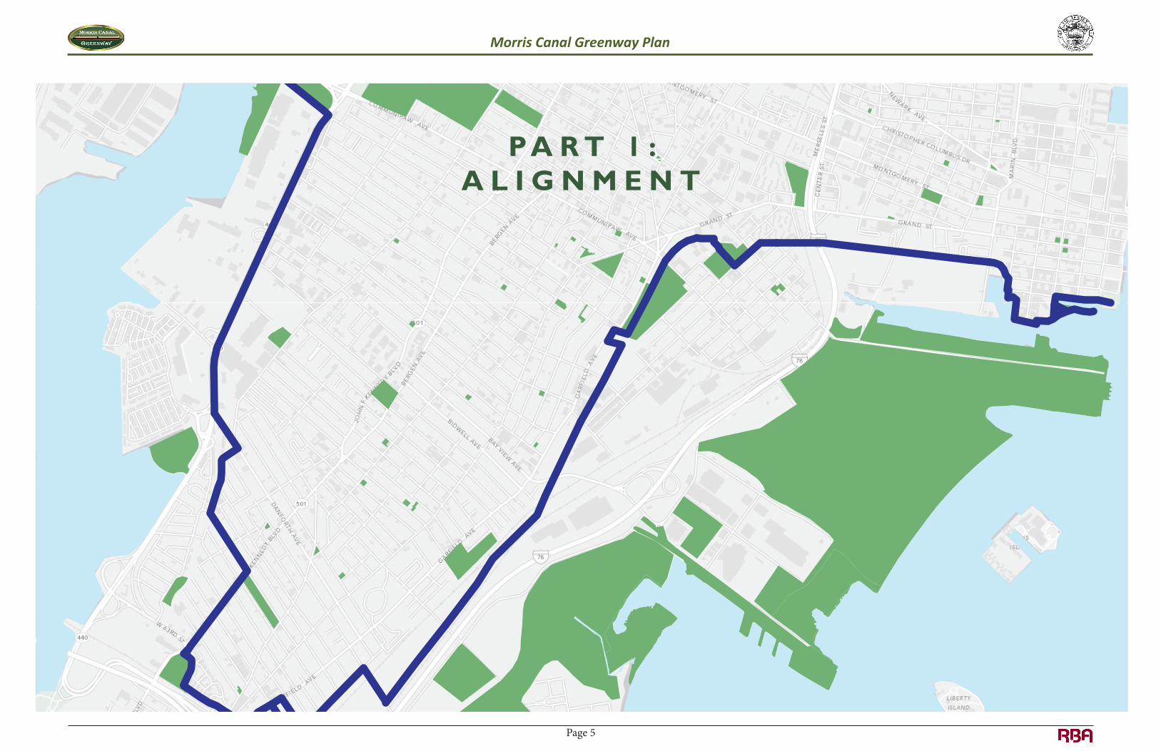
PA R T 1 :A L I G N M E N T
Morris Canal Greenway Plan Morris Canal Greenway Plan
Page 5

Part 1: Alignment
Existing Conditions along the Historic Morris Canal Alignment From 1836 until 1924, the Morris Canal in Jersey City followed a 6-mile course around the southern half of the City, avoiding the steeper grades of the upland Palisade formation and linking the Hudson and Hackensack Rivers. Most of the right-of-way has been filled in, and the fairly consistent grade of the circuitous route makes a proposed greenway manageable and attractive for walking and bicycling. Opportunities and constraints were determined based on GIS mapping, input from the Steering Committee, and a review of related plans. The study used the New Jersey Department of Environmental Protection (NJDEP) New Jersey Canals geographic information system (GIS) layer as a guide to locate the original route of the Morris Canal in the City of Jersey City.
The focus of the data collection and analysis was on the canal corridor and the area within a quarter mile of the corridor. A quarter mile is the distance that is most likely to be considered walkable by the greatest number of pedestrians. Several general opportunity categories were identified that would support the implementation of bicycle and pedestrian facilities along the former path of the Morris Canal. The categories include proximity to schools and other community features, proximity to transit and connectivity to existing and planned facilities. An environmental screening of the corridor was also conducted.
Connectivity to Recreation Facilities & Community Features The former Morris Canal right-of-way passes near or through residential neighborhoods, schools, parks, recreational facilities, trails, retail areas, and community centers. A greenway connecting all of these areas would encourage people to walk and bicycle for recreation as well as transportation. The path of the former Morris Canal has the potential to connect schools, neighborhoods, parks, Hudson Bergen Light Rail (HBLR) stations and bus stops as well as other bicycle and pedestrian facilities including the East Coast Greenway, Hackensack River Waterfront Walkway, Hudson River Waterfront Walkway and park trails. See Map 1: Proposed Long-Term Alignment and Recreation Facilities and Community Features.
Within a quarter mile of the former alignment of the Morris Canal there are:
• 20 schools o 18 in Jersey City, 2 in Bayonne o 8 public, 9 private, 3 charter o 11 elementary schools, 4 elementary/middle schools, 1 middle school, 3 high schools, and
1 special elementary school for children with autism • 1 college (New Jersey City University) • 24 municipal, county and state parks totaling 1,489 acres • 2 planned parks which will add an additional 50 acres • 3 ballfields • 2 recreation centers • 24 houses of worship
Morris Canal Greenway Plan Morris Canal Greenway Plan
Page 6
• 6 neighborhoods as defined by the Jersey City Economic Development Corporation2 • 3 health centers and a hospital
Transportation There are multiple opportunities to connect to public transit and alternative transportation options. See Map 2: Transportation Connections to the Long-Term Alignment. Within a quarter mile of the Morris Canal alignment there are:
• 5 Hudson-Bergen Light Rail stations • 153 NJ TRANSIT bus stops for 10 different NJ TRANSIT bus lines • 31% of the City’s existing signed bicycle network
Historic Features, Properties & Districts Establishment of a greenway would not only increase the recreational space in the City, it would also help to preserve culturally and historically valuable areas. This study identified 20 historic features along the former alignment of the Morris Canal. Some of the noteworthy canal features in Jersey City include the tide lock (22 east), the Little Basin, the Tidewater Basin (Morris Canal Big Basin), the Mill Creek outlet lock, and the tide lock (21 East), the pump house, the basin, and associated features on the Hackensack River. There are remnants of physical structures visible in the field for 12 of the 20 identified features. These features offer an opportunity to “tell the story” of the Morris Canal. See Map 3: Historic Features, Properties and Districts.
In addition, within a quarter mile of the corridor there are:
• 509 listed, identified or eligible Historic Properties • 10 listed, identified or eligible Historic Districts including the Morris Canal Historic District
Listed Historic Properties and Districts are included in the New Jersey or National Registers of Historic Places. Eligible Properties and Districts have been determined eligible for inclusion through federal or state processes as administered by the New Jersey Historic Preservation Office. Identified Properties and Districts have been identified through cultural resource survey or other documentation on file at the New Jersey Historic Preservation Office.
Environmental Conditions Within a quarter mile of the Morris Canal alignment there are:
• 161 known contaminated sites • 47 chromate sites • 12 groundwater contamination locations • 9 areas of NJDEP wetlands • 4 areas of species-based habitat including:
2 The neighborhood map developed by the Jersey City Economic Development Corporation can be found in the appendices.
o Rank 5 federal listed – shortnose sturgeon o Rank 4 state endangered – peregrine falcon o Rank 3 state threatened – black-crowned night-heron o Rank 3 state threatened – cattle egret
The presence of environmentally-sensitive areas on or near the former Morris Canal right-of-way does not necessarily preclude a greenway; mitigation may be possible. Many transportation corridors are contaminated from years of industrial use. Greenway development can be an opportunity to return these hazardous sites to safe and productive use. Many trails and greenways have taken advantage of brownfield funding, including Rhode Island's Woonasquatucket River Greenway Project, the Elkins Railyard redevelopment in West Virginia, and the Assabet River Rail Trail in Massachusetts.
Based upon a review of NJDEP GIS based environmental mapping and aerial photography, the project area minimally impacts wetlands and/or wetland transition area in two locations, one along Caven Point Road and one near the US 1&9 Bridge. Due to the NJDEP GIS-mapped presence of threatened/ endangered species/ habitats within the immediate vicinity of these two areas, there is the potential that these two wetland areas will be considered to be classified as exceptional resource value with an associated 150’ wide wetland transition area. Wetlands and/or waters impacted by proposed project improvements will require wetlands permits and/or transition area waivers from NJDEP in accordance with the New Jersey Freshwater Wetlands Protection Act. See Map 4: Environmental Conditions.
Morris Canal Greenway Plan Morris Canal Greenway Plan
Page 7

Map 1: Proposed Long-Term Alignment and Recreation Facilities & Community Features
Morris Canal Greenway Plan Morris Canal Greenway Plan
Page 8

Map2:TransportationConnectionstotheLong‐TermAlignment
Morris Canal Greenway Plan Morris Canal Greenway Plan
Page 9

Map3:HistoricFeatures,Properties&Districts
Morris Canal Greenway Plan Morris Canal Greenway Plan
Page 10

Map4:EnvironmentalConditions
Morris Canal Greenway Plan Morris Canal Greenway Plan
Page 11

Methodology and Route Selection Criteria The former Morris Canal corridor was divided into eight segments for analysis based on area characteristics, logical termini, potential connections and relationship with other planning studies and projects.
Figure1: The Morris Canal divided into eight segments
In addition to looking at the feasibility of routing the greenway on top of the historic Morris Canal path, alignments east and west (or north and south) of the canal were also evaluated. This resulted in three potential alignments for five of the eight segments, four potential alignments in two segments and only two viable alignments in one segment. However, the numbers of potential alignments as well as the routes were modified during the study based on input from the Steering Committee and the City. The map below shows the multiple routes evaluated for both the long-term and short-term greenway alignment.
All potential route options within the historic canal corridor were reviewed and evaluated based on opportunities, constraints, and selection criteria listed below:
1. PRIMARY GREENWAY EXPERIENCE a. Proximity to the historic Morris Canal alignment b. Off-street versus on-street facility (preference for off-street facilities) c. Potential for positive user experience (access to views, public art, enhanced sense of place)
2. TRAFFIC SAFETY d. Traffic Volume e. Traffic Speed f. Intersection Safety (complexity or number of intersections crossed)
3. ORIGINS AND DESTINATIONS / CONNECTIVITY g. Access to civic destinations (schools, houses of worship, hospitals, health centers, community
centers and recreation centers)
Figure 2: Routes evaluated for both the long-term and short-term greenway alignment
Morris Canal Greenway Plan Morris Canal Greenway Plan
Page 12

h. Access to parks and trails i. Access to tourism sites j. Proximity to designated bicycle routes k. Proximity to transit and bus stops l. Proximity to amenities and services (restaurants, bike shops, etc.)
4. IMPLEMENTATION FEASIBILITY / COST m. Implementation Feasibility n. Order of magnitude Construction Cost Estimate
The greenway route was selected with the future user in mind. Ultimately, the success of any bicycle and pedestrian facility will hinge on how well it functions as a transportation corridor and recreational destination. In addition, because the Morris Canal has great historic significance both for the region and for Jersey City, the greenway has the potential to highlight that history through interpretive public art and the design of the greenway itself. The vision statement describing the future greenway includes these concepts, which are reflected by the goals as “Primary Greenway Experience” and “Connectivity.” Consequently, these goals were also used as the criteria for selecting potential alignments.
Following the original alignment of the Morris Canal was the primary consideration in selecting the short-term and long-term alignments, as the Morris Canal route is in itself at the core of the greenway vision. Following the canal contributes to an authentic experience for the future user while also providing opportunities for historic interpretation.
Other factors were also considered as they directly impact user experience. “Traffic Safety” is an important criterion qualifying the suitability of alignment options. Although some traffic safety issues could be addressed through physical improvements, elements such as roadway geometry and traffic congestion make some options less desirable, especially for the short-term alignment, which is necessarily on roads and sidewalks. The fourth criterion, “Implementation Cost/ Feasibility” was also considered in the selection of options. Issues related to implementation can present insurmountable obstacles and prevent achievement of the Morris Canal goals.
The quality of the future user’s experience is influenced by issues related to other factors as well, such as the design, interpretive elements, perception of safety, and the ease of access to nearby destinations. However, these elements can be addressed in future phases and conditions can be improved over time as implementation progresses and neighborhood contexts change. It should be noted that greenways have been successfully incorporated into a wide variety of contexts, from residential to industrial, which can contribute to an interesting and diverse experience.
Proposed Long-Term Greenway Alignment While staying on or near the former path of the Morris Canal is the top priority for the long-term alignment, there are constraints that make it impossible for the entire greenway to follow the historic canal path. However, 41% of the proposed long-term alignment can be located on the historic canal path and 67% of the facility could be off-street. Property ownership was evaluated as one of the possible constraints affecting the feasibility of maintaining an alignment along the Morris Canal. A right-of-way report was prepared as part of the planning process to assess ownership along the proposed alignment. These issues are explored in the Implementation Strategy of the plan.
Unless otherwise specified, it has been assumed that an off-street facility can be accommodated through the redevelopment plan areas and proposed parks. The table below summarizes the proposed long-term alignment developed as part of this study. However, the alignment will change over time as development occurs and priorities change. The map on the following page provides an overview of the long-term alignment. Descriptions of the long-term alignment by segment appear after the map.
Table 1: Characteristics of the Proposed Long-Term Alignment Total
Length On Historic Canal
ROW Off-Street Facility* On-Street Facility
Located in Redevelopment
Plan Area
Segment Miles Mileage % of greenway Mileage % of
greenway Mileage % of greenway Mileage % of
greenway 1 0.93 0.93 10.9% 0.93 10.9% 0 0 0 0 2 0.86 0.86 10.1% 0.86 10.1% 0 0 0 0 3 0.95 0 0 0 0 0.95 11.1% 0 0 4 1.86 0** 0 0.52 6.1% 1.34 15.8% 0.37 4.4 5 0.95 0.64** 7.5% 0.95 11.1% 0 0 0.95 11.2 6 1.00 0.67 7.9% 0.67 7.9% 0.33 3.9% 1.00 11.8 7 0.58 0.35 4.1% 0.48 5.6% 0.10 1.2% 0.30 3.5 8 1.40 0.06 0.7% 1.29 15.2% 0.11 1.3% 0.46 5.4
Totals 8.5 3.4 41% 5.7 67% 2.8 33% 3.1 36% *Off-street facility includes shared use paths and segments with sidewalks and separated bicycle facilities (cycle tracks) ** Sections of both of these segments of the long-term alignment are located immediately adjacent to the historic canal alignment.
Morris Canal Greenway Plan Morris Canal Greenway Plan
Page 13

Map 5: Proposed Long-Term Alignment
Morris Canal Greenway Plan Morris Canal Greenway Plan
Page 14

Segment 1: Hackensack River to Culver Avenue The long-term greenway alignment through this section follows the historic canal path through a proposed County park and then along Route 440. Completed in 2011, The Route 440/Routes 1&9T Multi-Use Urban Boulevard and Through Truck Diversion Concept Development Study identifies a locally preferred alternative (LPA) for Route 440 that includes 12’ wide sidewalks and a buffered two-way bikeway (cycle track) in each direction of travel. The long-term greenway alignment will connect to the East Coast Greenway, Lincoln Park, the planned Hudson Bergen Light Rail extension as well as proposed residences and retail along the Route 440 corridor. It has been assumed that an off-street facility can be accommodated through the proposed park.
Segment 2: Culver Avenue to Danforth Avenue In the long-term, the proposed Morris Canal Greenway continues along the LPA identified for Route 440 that includes 12’ wide sidewalks and a buffered two-way bikeway (cycle track) in each direction of travel. The greenway would connect to the planned New Jersey City University West Campus expansion as well as proposed development along the Route 440 corridor.
0.93 miles; 100% on historic canal ROW; 100% off-street
0.86 miles; 100% on historic canal ROW; 100% off-street
Segment 3: Danforth Avenue to John F. Kennedy Boulevard This section of the proposed alignment is the same for both the short-term and long-term. Located east of the historic canal alignment, the greenway will be 100% on-street. The alignment follows Sullivan Drive, Bartholdi Avenue and John F. Kennedy Blvd. Since Bartholdi Avenue is a one-way street westbound, a contraflow lane could accommodate eastbound bicycle traffic. Possible connections include Columbia Park, Our Lady-Mercy Catholic School, and bus stops along Kennedy Blvd. The historic Morris Canal alignment is located through the Country Village neighborhood through this segment. Routing the greenway on top of the historic canal alignment might be considered in the future pending public support.
0.95 miles; 0% on historic canal ROW; 0% off-street
Morris Canal Greenway Plan Morris Canal Greenway Plan
Page 15

Segment 4: John F. Kennedy Boulevard to Chapel Avenue This segment of the proposed greenway travels alongside the historic canal along an existing off-street path through Hudson County’s Mercer Park. However, major roadways including the on- and off-ramps of Exit 14A of the New Jersey Turnpike present an insurmountable obstacle that cannot be easily crossed. Therefore, the segment of the historic canal that includes the bend at the southern end of the canal known as Fiddler’s Elbow as well as segments of the historic canal path through the City of Bayonne are not currently included in the proposed long-term greenway alignment. The safest and most accessible option available is to route the long-term greenway along the local street network utilizing Merritt Street, Gates Avenue, Seaview Avenue, Princeton Avenue, and Linden
Avenue before becoming an off-street facility through the Danforth Transit Village Redevelopment Plan Area.3 The Morris Canal historic alignment is located in the center of this redevelopment plan area. Therefore, the greenway alignment has been moved one parcel east of the historic alignment in order to maintain development potential. The greenway through this segment will provide connections to the City of Bayonne, Mercer Park, and the Danforth Avenue Light Rail station. The City’s Department of Public Works (DPW) will move to a new facility just south of Linden Avenue. While there are no plans to permit public access through the site, it may be possible to include a spur from the greenway to the DPW complex. There are plans to reconstruct the NJ Turnpike 14A exit, and there may be an opportunity for these plans to include pedestrian and bicycle access to the former Morris Canal in this area.
3 The maps in this section do not show the boundaries of the redevelopment plan areas. But rather, they indicate where the proposed long-term greenway alignment intersects the redevelopment plan area boundary. See Map 4: Proposed Long-Term Alignment for the boundaries of the redevelopment plan areas.
1.86 miles; 0% on historic canal ROW; 28% off-street
Segment 5: Chapel Avenue to Caven Point Avenue This segment of the proposed long-term route is located entirely within redevelopment plan areas and is proposed to be a completely off-street facility. Just like the Danforth Transit Village Redevelopment Plan Area, the historic canal alignment is located in the middle of the Claremont Industrial Redevelopment Plan Area. Therefore, the alignment through a third of this section has also been moved to east of the historic canal in order to maintain development potential. Two-thirds of the proposed alignment is on top of the historic canal alignment. Remnant concrete abutments and piers of the bridge built during the early 20th century to carry the Lehigh Valley Railroad’s National Docks Railway over the canal offer an opportunity for historic interpretation. A new crossing of the Hudson-Bergen Light Rail will be required.
0.95 miles; 67% on historic canal ROW; 100% off-street
Morris Canal Greenway Plan Morris Canal Greenway Plan
Page 16

Segment 6: Caven Point Avenue to Johnston Avenue The long-term greenway alignment follows the historic canal path as an off-street facility through the Canal Crossing Redevelopment Plan Area, Berry Lane Park, and around the Whitlock Cordage Complex. The path leaves the historic canal alignment in order to get around the Hudson-Bergen Light Rail (HBLR) embankment between the Canal Crossing Redevelopment Area and Berry Lane Park. The light rail embankment includes a 54” water main that prevents the greenway from going through. Therefore, the greenway will need to be routed to Garfield Avenue to get around the embankment. It is proposed that the sidewalk along Garfield Avenue be at least 10’, preferably 15’ wide in order to accommodate both pedestrians and bicyclists. The long-term greenway alignment also deviates from the Morris Canal to avoid the Jersey City Regional Day
School, which is built on top of the historic canal alignment. In this segment, the greenway will connect to the Garfield Avenue HBLR Station, Berry Lane Park, Lafayette (Ercel Webb) Park, Elementary School 22, the Jersey City Regional Day School, and the Whitlock Cordage Company Buildings Historic District. Design work for the section of the Morris Canal Greenway through Berry Lane Park is currently underway.
1 mile; 67% on historic canal ROW; 67% off-street
Segment 7: Johnston Avenue to Jersey Avenue The long-term alignment through this section utilizes the existing sidewalk located on top of the former Morris Canal alignment through Lafayette Village. In order to accommodate both pedestrian and bicyclist traffic, the sidewalk would need to be widened to a preferred minimum of 10’. The path crosses Pacific Avenue near the National Docks Railway/Morris Canal and Pacific Avenue Bridge. This steel truss bridge was completed in 1909 to carry the Lehigh Valley Railroad’s National Docks Railway over the Morris Canal and Pacific Avenue. The alignment continues through the Grand Jersey redevelopment plan area. The proposed alignment will follow the proposed street grid for the redevelopment plan area. It is recommended that the street grid include bicycle and pedestrian facilities separated from motor vehicle traffic. Destinations in this segment include the Jersey City Medical Center and Liberty State Park.
0.58 miles; 60% on historic canal ROW; 84% off-street
Morris Canal Greenway Plan Morris Canal Greenway Plan
Page 17

Segment8:JerseyAvenuetotheHistoricMorrisCanalSectionofLibertyStateParkandColgatePark
After crossing Jersey Avenue, the greenway alignment enters the Liberty Harbor North Redevelopment Plan Area. Through this area, the long‐term alignment will parallel the Hudson‐Bergen Light Rail tracks to the south before joining the Hudson River Waterfront Walkway (HRWW) until the eastern terminus of the greenway. This section will require a new at‐grade crossing of the light rail tracks at Jersey Avenue. While it is assumed that the path paralleling the light rail tracks will be off‐street, the greenway will have to be routed on‐street between the light rail tracks and the 18 Park development currently under construction at the corner of Marin Boulevard and the Marin Boulevard Light Rail Station. The streetscape plan for 18 Park includes a one‐way eastbound street between the building and the light rail tracks and platform. There
is insufficient space between the planned street and the railroad tracks for an off‐street bicycle and pedestrian facility in this area. Therefore, the greenway will need to be accommodated on‐street. Because the street is one‐way, westbound bicyclists would need to be accommodated with a contraflow bicycle lane. After leaving the Liberty Harbor North Redevelopment Plan Area, it is proposed that the Morris Canal Greenway utilize the completed HRWW until the Morris Canal Section of Liberty State Park. While the former Morris Canal path is located north of the proposed long‐term alignment along Dudley Street, the HRWW was chosen as the proposed alternative, because it is an existing off‐street facility. Based on input from the Steering Committee, it was determined that both Colgate Park and the Morris Canal Section of Liberty State Park should serve as the eastern termini of the Morris Canal Greenway in Jersey City. Adding Colgate Park as a terminus provides a stronger connection to the Hudson River Waterfront Walkway.
ProposedShort‐TermGreenwayAlignmentIn the short‐term, the Morris Canal Greenway through Jersey City can be completed utilizing the City’s street network and existing off‐street shared use paths. While only 3% of the proposed 9.3 mile short‐term alignment can be located on the historic canal path (excluding the Route 440 pedestrian alternative route), travelers along the short‐term route can help to build support for the long‐term Greenway, designed to be largely an off‐street facility that will better meet the project’s Vision.
1.4 miles; 4% on historic canal ROW; 92% off‐street
Morris Canal Greenway Plan Morris Canal Greenway Plan
Page 18

Map 6: Proposed Short-Term Alignment
Morris Canal Greenway Plan Morris Canal Greenway Plan
Page 19

Short-Term Route Roadway Characteristics The table below follows the short-term proposed alignment from west to east. The speed limit in Jersey City is 25 mph for all streets, with the exception of sections of Garfield Avenue and Caven Point Road. Functional classification information came from Appendix of the Circulation Element of the Jersey City Master Plan.
Table 2: Roadway Characteristics of the Proposed Short-Term Alignment Street Name Functional
Classification Direction of Travel Length of
Greenway along Street
Notes
Clendenny Ave Local Residential
One-Way East 1,335’
Bennett St Local Residential
Two-Way 350’
Williams Ave Local Residential
One-Way West 1,180’
Mallory Ave Local Residential
Two-Way 2,740’
Culver Ave Local Residential
Two-Way 890’
West Side Ave (CR 627)
Local Residential/ Minor Collector
Two-Way 3,970’
NJ 440 Urban Principal Arterial
Two-Way 6,500’ Pedestrian Alternate Route
Danforth Ave (CR 602)
Major Collector
Two-Way 200’
Sullivan Dr (CR 709)
Local Residential
Two-Way 1,500’
Bartholdi Ave Local Residential
1,420’
JFK Blvd (Rt. 501)
Major Collector
Two-Way 2,000’ County Road
Off-street through Mercer Park
Off-street 750’ Existing Path
Merritt St (CR 707)
Minor Collector
Two-Way 1,540’ Truck Route
Garfield Ave Minor Collector
Two-Way 865’
Gates Ave Local Residential
One-Way West 850’
Seaview Ave Local Residential
One-Way East 780’
Street Name Functional Classification
Direction of Travel Length of Greenway along Street
Notes
Princeton Ave Local Residential
Two-Way 2,585’
Danforth Ave (CR 602)
Major Collector
Two-Way 435’
Garfield Ave Minor Collector
Two-Way 6,930’ Partly a truck route
Carteret Ave Local Residential
Two-Way 1,100’ Partly a truck route
Pacific Ave Minor Collector
Two-Way 2,585’ Part of City’s planned bicycle network
Communipaw Ave (CR 612)
Major / Minor Collector
Two-Way 1,055’ Truck Route
Manning Ave Local Residential
Two-Way between Communipaw Ave and Lafayette St; One-Way South between Lafayette and Maple St
940’
Maple St (CR 722)
Local Residential
One-Way West 785’
Van Horne St Local Residential
One-Way North 460’
Halladay St Local Residential
One-Way South 455’
Johnston Ave (CR 614)
Local Residential / Minor Collector
Two-Way 3,065’
Jersey Ave Bridge
Off-Street 1,130’
Parking lot 2,240’ Private Marin Blvd Local
Residential Two-Way 920’
Path alongside Light Rail
Off-Street 660’
Van Vorst St Local Residential
One-Way North 285’
Hudson River Waterfront Walkway
Off-Street 1,600’ Existing path
Morris Canal Peninsula Park
Off-Street 900’ Existing path
Morris Canal Greenway Plan Morris Canal Greenway Plan
Page 20


![CANAL [T] Canal Soth Florida](https://img.pdfslide.us/doc/110x75/55cf9803550346d03395034f/canal-t-canal-soth-florida.jpg)