Embed Size (px)
Citation preview


Parker Lands Master Plan
PAGE | i
PARKER LANDS Major Redevelopment Site (Site ‘G’) MASTER PLAN
John S. Wintrup, B.A. (Hons), M.Sc. Planning, MCIP, RPP J. Wintrup Consulting Ltd.
Michelle E Richard, MCP, MCIP, RPP M. Richard & Associates Ltd.
December 2017

Parker Lands Master Plan
PAGE | ii
Parker Lands Master Plan
PAGE | iii
Table of Contents
1 INTRODUCTION ...........................................................................................................................1
1.1 PURPOSE OF THE PLAN ......................................................................................................................1 1.1.1 Policy Framework ............................................................................................................................. 2
1.2 PLANNING AREA AND CONTEXT ...........................................................................................................8 1.2.1 Planning Process ............................................................................................................................... 8 1.2.2 Plan Area .......................................................................................................................................... 9 1.2.3 Boundaries of the Plan Area ............................................................................................................. 11 1.2.4 Surrounding the Plan Area ............................................................................................................... 12 1.2.5 Existing Land-Use in and Around Plan Area ..................................................................................... 14 1.2.6 Existing Zoning in and Around Plan Area ......................................................................................... 15 1.2.7 Existing Features .............................................................................................................................. 17 1.2.8 Environmental Assessment / Contaminated & Impacted Sites ........................................................ 19 1.2.9 Existing and Planned Infrastructure & Services ................................................................................ 20 1.2.10 Opportunities and Constraints ......................................................................................................... 27
1.3 INTERPRETING THE PLAN .................................................................................................................. 28 1.3.1 Authority of the Plan ........................................................................................................................ 28 1.3.2 Time Frame of the Plan .................................................................................................................... 28 1.3.3 Policies, Applications and Interpretations ........................................................................................ 29 1.3.4 Maps ................................................................................................................................................. 29
1.4 MONITORING, REVIEW AND EVALUATION ............................................................................................ 30 1.5 AMENDMENTS TO THE PLAN ............................................................................................................. 30 1.6 SUPPORTING STUDIES...................................................................................................................... 30
2 PLANNING VISION AND OBJECTIVES ........................................................................................... 31
2.1 VISION......................................................................................................................................... 31 2.2 OBJECTIVES ................................................................................................................................... 32
2.2.1 Placemaking: Foster Quality Places and Identity ............................................................................. 32 2.2.2 Connected ......................................................................................................................................... 32 2.2.3 Sustainability: Environmental, Social and Economic ........................................................................ 32
3 LAND-USE CONCEPT ................................................................................................................... 33
3.1 GENERAL ...................................................................................................................................... 33 3.1.1 General Policies ................................................................................................................................ 33
3.2 URBAN DESIGN POLICIES .................................................................................................................. 34 3.2.1 Objectives ......................................................................................................................................... 34 3.2.2 Policies .............................................................................................................................................. 34
3.3 DENSITY ....................................................................................................................................... 35 3.3.1 Objectives ......................................................................................................................................... 35 3.3.2 Policies .............................................................................................................................................. 35
3.4 PARKING POLICIES .......................................................................................................................... 36 3.4.1 Objective ........................................................................................................................................... 36 3.4.2 Policies .............................................................................................................................................. 36
3.5 URBAN NEIGHBOURHOOD POLICY AREA .............................................................................................. 37 3.5.1 Objective ........................................................................................................................................... 37 3.5.2 Policies .............................................................................................................................................. 37

Parker Lands Master Plan
PAGE | iv
3.6 LIMITED USES POLICY AREA .............................................................................................................. 38 3.6.1 Objectives ......................................................................................................................................... 38 3.6.2 Policies .............................................................................................................................................. 38
3.7 RAPID TRANSIT STATION NODE POLICY AREA ........................................................................................ 39 3.7.1 Objectives ......................................................................................................................................... 39 3.7.2 Policies .............................................................................................................................................. 39
3.8 GREEN AND OPEN SPACES POLICIES .................................................................................................... 40 3.8.1 Objective ........................................................................................................................................... 40 3.8.2 Policies .............................................................................................................................................. 40
3.9 NATURAL LANDS POLICY AREA .......................................................................................................... 41 3.9.1 Objectives ......................................................................................................................................... 41 3.9.2 Policies .............................................................................................................................................. 41
3.10 RAILWAY CORRIDOR POLICIES ........................................................................................................... 42 3.10.1 Objectives ......................................................................................................................................... 42 3.10.2 Policies .............................................................................................................................................. 42
4 TRANSPORTATION AND SERVICING POLICIES .............................................................................. 43
4.1 TRANSPORTATION INFRASTRUCTURE ................................................................................................... 43 4.1.1 Objectives ......................................................................................................................................... 43 4.1.2 Policies .............................................................................................................................................. 44
4.2 WATER, WASTE WATER AND LAND DRAINAGE ...................................................................................... 45 4.2.1 Objective ........................................................................................................................................... 45 4.2.2 Policies .............................................................................................................................................. 45
5 IMPLEMENTATION ..................................................................................................................... 49
5.1 ACTIONS ...................................................................................................................................... 49 5.1.1 Enactment ........................................................................................................................................ 49 5.1.2 Land Development Regulations ........................................................................................................ 49
5.2 STAGING AND PHASING ................................................................................................................... 50 5.3 COST SHARING .............................................................................................................................. 50 5.4 DEVELOPMENT APPLICATIONS ........................................................................................................... 50 5.5 URBAN DESIGN GUIDELINES: SITE PLAN APPROVAL ................................................................................ 51
5.5.1 Purpose ............................................................................................................................................. 51 5.5.2 Policies .............................................................................................................................................. 51 5.5.3 Approval and Amendment Procedures ............................................................................................. 51
6 DEFINITIONS .............................................................................................................................. 53
7 LIST OF FIGURES ......................................................................................................................... 55
8 MAPS ........................................................................................................................................ 57
9 APPENDICES .............................................................................................................................. 62
APPENDIX A: ENGAGEMENT REPORT ......................................................................................................... 62 APPENDIX B: ENVIRONMENTAL OVERVIEW ................................................................................................. 64 APPENDIX C: WATER, WASTEWATER AND STORMWATER SERVICING REPORT ...................................................... 66 APPENDIX D: TRAFFIC ANALYSIS AND OPPORTUNITY MEMO............................................................................ 68 APPENDIX E: URBAN DESIGN GUIDELINES: URBAN NEIGHBOURHOOD POLICY AREA ............................................. 70 APPENDIX F: PARKER LANDS: ENSURING SUCCESSFUL PRAIRIE TOD MEMO ....................................................... 72
Parker Lands Master Plan
PAGE | 1
1.1 Purpose of the Plan
The purpose of the Parker Lands Major Redevelopment Site Master Plan (“the Plan”) is to provide direction on the planned and orderly development of land in a major redevelopment site as identified by Complete Communities. The Plan is a guide for community development with the understanding that specific applications will evolve as circumstances and influences change over time. In accordance with the City of Winnipeg Charter, all future development within the planning area must be consistent with the policies of the Plan. The Plan ensures that the coordination of proposed local infrastructure serving the new land-uses in the neighbourhood fits within the planned regional infrastructure. In addition it provides details which outline actions and strategies that may inform users about the constraints, coordinate the new infrastructure, fulfill the vision for the development lands under OurWinnipeg, and increase certainty for all parties regarding the future of the lands.
The Vision, Principles and Policies of the Plan are consistent with OurWinnipeg Plan By-law No.
67/2010 the City’s Development Plan; Complete Communities, and the City’s Transit-Oriented Development Handbook. The work on the Plan began in early 2014 in consultation and collaboration with a number of stakeholders including various City of Winnipeg departments, the General Council of Winnipeg Community Centres, Manitoba Hydro, CNR Rail, the Division Scolaire Franco-Manitobaine, and the Winnipeg School Division. Input was also received from representatives of the Winnipeg Humane Society, the Brenda Leipsic Off-Leash Dog Park users, and the local City Councilor. Development of the Plan was informed and is supported by a number of background reports, including engineering and environmental studies, which were all reviewed by the City of Winnipeg and shared with stakeholders.
1 INTRODUCTION

Parker Lands Master Plan
PAGE | 2
1.1.1 Policy Framework
The following sections set out the series of City of Winnipeg policy decisions that inform development expectations for the Parker Lands upon which this Plan is built upon. Since 2007, a progression of policy decisions has occurred:
Removal from the Industrial Lands Inventory – Employment Lands Strategy, 2008
Winnipeg Residential Land & Infill Strategy, 2009
City Council approves the sale of a portion of the Parker Lands to a private developer – City condition of sale is that a developer led secondary plan be undertaken, 2009
Designation as high density mixed use site – OurWinnipeg, 2011
Transportation Master Plan, 2011
Winnipeg Transit-Oriented Development Handbook, 2012
Council commissioned a study for realignment of the transit corridor for Southwest Rapid Transit Corridor Stage 2: Alignment Study Final Report, 2013
Council approves the realignment of the Transit Corridor – Southwest Rapid Transit Corridor Alignment Stage 2, 2014
City of Winnipeg – Stage 2 – Southwest Rapid Transit Corridor Project P3 Business Case Summary, April 2014
With each policy decision, the City of Winnipeg reinforced its expectation that the Parker Lands, Major Redevelopment Site ‘G’ will be developed as high density mixed use.
1.1.1.1 Pre-OurWinnipeg
Conference Board of Canada - Population Forecast (2007) The Conference Board of Canada was commissioned to forecast growth for the City of Winnipeg from 2007 to 2031. It predicted that Winnipeg would grow by 188,000 people and 87,000 housing units between 2008 to 2031 or 3800 units per year. It predicted an annual growth rate between 1.5% and 1.9% or approximately 7520 people per year. In the lead-up to the OurWinnipeg plan, the City commissioned two critical studies including the Winnipeg Employment Lands Strategy and the Residential Land and Infill Strategy. Winnipeg Employment Lands Strategy (2008) The City’s Employment Lands Strategy (2008) provided the foundation for the OurWinnipeg plan. It set out a robust vision to accommodate Winnipeg’s changing economy. It looked at the City’s growing sectors and identified land that best aligned with those sectors. It also looked at areas within the City’s industrial land supply that weren’t functioning or were considered obsolete and recommended that they be removed and repurposed for a higher and better use. The strategy looked at all industrial lands against a set of criteria including: access, utilities, regulation, adjacent uses, amenities, links to industry, site configuration and size. It identified the Parker Lands as unsuitable for industrial development for the following reasons:

Parker Lands Master Plan
PAGE | 3
Transected by major utility corridor makes it difficult to develop for industrial purposes;
Major transportation access issues;
Requires major infrastructure improvements including sewer separation that could best be accommodated through redevelopment to another use; and
Adjacency to existing neighbourhoods.
The strategy recommended that the Parker Lands be removed from the industrial inventory and be designated for ‘neighbourhood development’.
Winnipeg Residential Land and Infill Strategy (2009) This report looked at overall anticipated housing starts to 2031 based on projected growth and demographic change, using the Conference Board of Canada 2007 population forecast. It assessed the current development patterns of the city and the overall implications of these development patterns. It looked at the development capacity for a range of land categories including greenfield, infill, redevelopment land and rural lands. It also reviewed and assessed industrial lands identified for removal in Employment Lands Strategy, including the Parker Lands. The Strategy identified the Parker Lands as critical supply of land if the City is to accommodate residential/mixed use growth within its’ urban boundary. It states that without considering other forms of development such as redevelopment sites and only relying on greenfield expansion (suburban areas), the City of Winnipeg will have insufficient land capacity (15 years supply) to accommodate the anticipated housing starts required by 2031 (Winnipeg Residential Land and Infill Strategy, pg. 89; Winnipeg Complete Communities Direction Strategy, pg. 2). The Strategy further states that even with a build out of existing suburban areas, redevelopment sites such as Parker Lands at 25 du/acre (net), identified infill (only using vacant land) and assuming development of downtown surface parking lots (3,954 units), the City of Winnipeg would still only have 18.6 years of land supply (Winnipeg Residential Land and Infill Strategy, pg. 95). It further suggested that the Parker Lands site would be most efficiently developed to a mid/high net density scenario to justify infrastructure and transportation interventions (Winnipeg Residential Land and Infill Strategy, pg. 100). The strategy concluded that the Parker Lands site along with other identified redevelopment sites were critical inputs into the land supply needed to meet the City of Winnipeg’s growth forecast to 2031.
1.1.1.2 OurWinnipeg and Complete Communities
In 2011, Our Winnipeg, the City’s Development Plan, was approved by the Province of Manitoba and adopted by City Council in accordance with The City of Winnipeg Charter. It was based on the Conference Board of Canada 2009 population forecast, the Employment Lands Strategy and the Residential Land and Infill Strategy. It directs the City to support redevelopment and densification in underutilized lands. Complete Communities, the City’s land use and development guide, was also adopted that year by City Council as a Secondary Plan applying to the entire city, in accordance with The City of Winnipeg Charter.
Parker Lands Master Plan
PAGE | 4
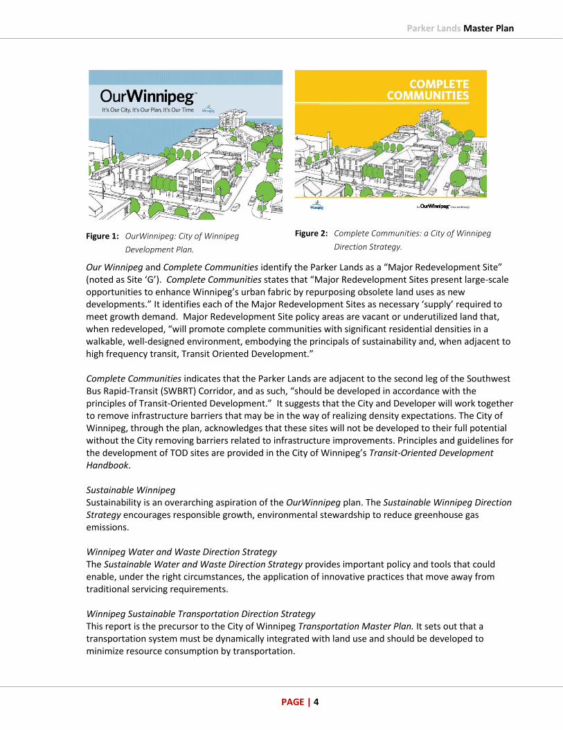
Figure 1: OurWinnipeg: City of Winnipeg
Development Plan.
Figure 2: Complete Communities: a City of Winnipeg
Direction Strategy.
Our Winnipeg and Complete Communities identify the Parker Lands as a “Major Redevelopment Site” (noted as Site ‘G’). Complete Communities states that “Major Redevelopment Sites present large-scale opportunities to enhance Winnipeg’s urban fabric by repurposing obsolete land uses as new developments.” It identifies each of the Major Redevelopment Sites as necessary ‘supply’ required to meet growth demand. Major Redevelopment Site policy areas are vacant or underutilized land that, when redeveloped, “will promote complete communities with significant residential densities in a walkable, well-designed environment, embodying the principals of sustainability and, when adjacent to high frequency transit, Transit Oriented Development.” Complete Communities indicates that the Parker Lands are adjacent to the second leg of the Southwest Bus Rapid-Transit (SWBRT) Corridor, and as such, “should be developed in accordance with the principles of Transit-Oriented Development.” It suggests that the City and Developer will work together to remove infrastructure barriers that may be in the way of realizing density expectations. The City of Winnipeg, through the plan, acknowledges that these sites will not be developed to their full potential without the City removing barriers related to infrastructure improvements. Principles and guidelines for the development of TOD sites are provided in the City of Winnipeg’s Transit-Oriented Development Handbook.
Sustainable Winnipeg Sustainability is an overarching aspiration of the OurWinnipeg plan. The Sustainable Winnipeg Direction Strategy encourages responsible growth, environmental stewardship to reduce greenhouse gas emissions.
Winnipeg Water and Waste Direction Strategy The Sustainable Water and Waste Direction Strategy provides important policy and tools that could enable, under the right circumstances, the application of innovative practices that move away from traditional servicing requirements. Winnipeg Sustainable Transportation Direction Strategy This report is the precursor to the City of Winnipeg Transportation Master Plan. It sets out that a transportation system must be dynamically integrated with land use and should be developed to minimize resource consumption by transportation.
Parker Lands Master Plan
PAGE | 5
1.1.1.3 Post- OurWinnipeg
A series of policy decisions were approved by Council subsequent to the adoption of OurWinnipeg that further reinforce the City’s expectation that the Parker Lands, along with the other ten Major Redevelopment Sites, should be redeveloped to support significant levels of mixed use, high density development. Perhaps the most significant decision was the realignment of the Southwest Rapid Transit Corridor, Stage 2 through the Parker Lands.
Conference Board of Canada 2012 Population Forecast Revision Since OurWinnipeg – Complete Communities was adopted in 2011, the City of Winnipeg revised its 2009 growth forecast, predicting more growth. In fact, the OurWinnipeg population forecast, conducted by the Conference Board of Canada, projected that annual population growth over the period of 2007 to 2031 will average 7,525 persons per year. In 2012, this forecast was adjusted to 9,000 persons per year. This unexpected growth was reconfirmed through the 2016 Census. The population percentage change between 2011 and 2016 for Winnipeg’s growth rate was 6.3%. The City of Winnipeg 2018 Community Trends and Performance Report further stated that it expects annual growth to be even higher at 12,500 persons per year to 2021. Winnipeg is poised well to accommodate this unexpected growth because of the OurWinnipeg plan and its identification of redevelopment sites such as the Parker Lands. Without the plan, the City would be left with few options to accommodate its growth. It would be likely that this growth would be accommodated elsewhere in surrounding municipalities, missing an opportunity for Winnipeg to benefit from this growth. In fact, the City would be harmed without sites such as the Parker Lands through loss of municipal revenue, less resources to direct to infrastructure improvements and more ‘wear and tear’ of Winnipeg infrastructure from people commuting into the city. Transportation Master Plan (Adopted by Winnipeg City Council – November 16th, 2011) The Winnipeg Transportation Master Plan (TMP) was adopted after OurWinnipeg. It strongly reinforced the need for a greater proportion of the City’s future growth to be allocated within the existing built boundary to reduce impact on existing roadway infrastructure and encourage other less harmful transportation choices to the automobile including active transportation and transit. The Plan provided a framework that guides how the Major Redevelopment Site will be developed to efficiently and effectively accommodate all transportation modes to improve access, movement and mobility. The TMP states, “A key goal in OurWinnipeg is to accommodate a greater proportion of the City’s future growth within the existing built boundary. This would be accomplished through redevelopment and intensification in the City’s transit-supportive land use areas: the downtown, mixed-use centres, mixed-use corridors, and major redevelopment sites” (Section 4 Integrating Transportation and Land Use; Winnipeg Transportation Master Plan, page 30). The Transportation Master Plan further clarified the specific importance of the Parker Lands Major Redevelopment Site by introducing a possible Southwest Rapid Transit Corridor alignment concept that runs through the site.

Parker Lands Master Plan
PAGE | 6
Winnipeg Transit-Oriented Development Handbook (Adopted by Wpg. City Council – Feb 22nd, 2012) The Winnipeg Transit-Oriented Development Handbook (TOD Handbook) was endorsed as policy (TR-006) by Winnipeg Council on February 22, 2012. It established the following definition of TOD:
“Moderate to higher density compact mixed-use development, located within an easy five to ten minute (approximately 400m to 800m) walk of a major transit stop. TOD involves high quality urban development with a mix of residential, employment and shopping opportunities, designed in a pedestrian oriented manner without excluding the automobile. TOD can be new construction or redevelopment of one or more buildings whose design and orientation facilitate the use of convenient and sustainable modes of transportation, including public transit and Active Transportation.” (Section 2A – TOD Defined; TOD Handbook, page 6).
Figure 3: Winnipeg Transit-Oriented Development Handbook

Parker Lands Master Plan
PAGE | 7
Southwest Rapid Transit Corridor Stage 2 – Alignment Study – January 2013 The City of Winnipeg commissioned an alignment study to review the Southwest Rapid Transit Corridor Alignment as described in OurWinnipeg - Complete Communities. It looked at a series of alignment options and concluded that the OurWinnipeg alignment be rerouted through the Parker Lands to maximize growth and densification opportunity. The study focused largely on OurWinnipeg – Complete Communities directive and the Transit-Oriented Development Handbook to use rapid transit to maximize development potential of Major Redevelopment Sites:
“In order to maximize the development potential of both the Major Redevelopment Sites and the viability of the transit system, these lands should be developed in accordance with the principles of Transit-Oriented Development.” (Complete Communities, page 66). “Redevelopment Sites feature Neighbourhood Centres, including Parks, Places, and Open Spaces, that are the nodes with which to integrate public transit stations. The City’s policy is to help reduce Major Redevelopment Site barriers related to the complexity of location, infrastructure, land assembly, and potential contamination.” (Complete Communities, page 67).
City of Winnipeg Housing Policy – Endorsed by Winnipeg City Council – September 25th, 2013 City of Winnipeg’s Housing Policy (ED-006) was endorsed by Winnipeg Council on September 25, 2013. The purpose of the Winnipeg Housing Policy is to support the implementation of OurWinnipeg and Complete Communities to achieve a sustainable and healthy housing environment that meets the needs of the Winnipeg population. The City of Winnipeg Housing Policy is focused on key areas within the jurisdiction of the City of Winnipeg, and provides a leadership role to help strengthen policies and programs of other levels of government to ensure they support needs of the Winnipeg population. The City of Winnipeg Housing Policy forms an integral part of the overall policy framework and by-laws relevant to housing in Winnipeg. Some of the priorities are:
Targeted Housing Development – The objective is to encourage new housing development that promotes and supports City of Winnipeg policy goals. Including affordable housing, diverse housing options, universal design, and appropriate density to support infrastructure and creates complete communities;
Neighbourhood Revitalization - Support for revitalization and maintenance of existing housing that promotes adequate, safe living conditions for homeowners and tenants, and supports safe, orderly, viable and sustainable communities which brings new life back to Mature Communities.

Parker Lands Master Plan
PAGE | 8
HOW DO THESE LANDS FIT WITH COUNCIL’S HOUSING POLICY?
POLICY B.2. The City will encourage and support housing development that:
(a) Supports thriving, Complete Communities in the Downtown, Major
Redevelopment Sites, Centres and Corridors to increase residential variety
and densification where appropriate; or
(b) Increases the supply of rental units to more effectively address demand.
Re-alignment of SWRTC Phase 2 through the Parker Lands Major Redevelopment Site – Stage 2 – Approved by Winnipeg City Council – June 25th, 2014 Winnipeg City Council approved the realignment of SWRTC Stage 2 through the Parker Lands Major Redevelopment Site on June 25th, 2014. Council, in their decision, cited the imperative to align rapid transit to Major Redevelopment Sites, including Parker Lands, to maximize opportunity afforded through Transit-Oriented Development.
1.2 Planning Area and Context
1.2.1 Planning Process
1.2.1.1 Planning as a Collaboration
The Plan encourages community and stakeholders involvement, and is the product of a collaborative and iterative process that solicited feedback from land owners, the Winnipeg Public Service, elected officials, key stakeholders, special interest groups, community organizations, neighbourhood groups and adjacent community residents to shape the public interest on this planning matter. One-on-one meetings, public open houses, and a series of meetings with the City’s Technical Advisory Committee (TAC) with representatives from Public Works, Winnipeg Transit, Water and Waste, Community Services, City Naturalist, Parks, Emergency Services, and Planning and Property Development departments were held to share the Plan’s vision with stakeholders; assess infrastructure and community services capacities; and determine future requirements to implement the new land-uses and transportation connections in the Planned Area. This active consultation of sharing information and gathering feedback resulted in several modifications to the project to reflect and address the opinions being expressed. The solicitation of input is an important component of the planning process as a means of generating planning policies that reflect the feedback, and providing a basis of support for the general planning directions of the Secondary Plan. A complete engagement report documenting the stakeholder feedback received through the active consultation with the public and stakeholders is included as an Appendix in this Plan.

Parker Lands Master Plan
PAGE | 9
1.2.1.2 Public Engagement
A series of public open houses to promote discussion were held at well-advertised venues, of varying times and dates in conjunction with numerous one-on-one interviews, meetings and communication exchanges with individuals and key stakeholders. This active consultation, in an inclusive, transparent and fair process allowed interested parties an opportunity to articulate their positions on this planning matter. Relevant project information was provided to all those engaged. The opinions and information gathered were shared back with all other stakeholders as their input and the implications of their comments were included in the next iteration of the planning process demonstrated in this Plan.
1.2.2 Plan Area
The Parker Lands represent a prominent brownfield, infill site in south central Winnipeg with redevelopment potential as identified in OurWinnipeg where it is cited as one the Major Redevelopments Sites (MRS) and labelled in Complete Communities as Site ‘G’ from Transformative Areas (see figure 4 below). It is one of eleven sites identified and included in the City’s supply/demand analysis to meet current growth projections to 2031. MAJOR REDEVELOPMENT SITES
Figure 4: Major Redevelopment Sites in Winnipeg (from Complete Communities, pg. 65)

Parker Lands Master Plan
PAGE | 10
Administratively, the Parker Lands are within the River Heights-Fort Garry Ward and almost entirely in the larger Parker Neighbourhood 1.654). A small portion is in the Beaumont Neighbourhood. It is centrally located in Winnipeg close to Downtown (approximately 10 minutes by car or bus), and approximately the same distance to the University of Manitoba, St. Vital and Polo Park shopping areas.
NEIGHBOURHOODS
Figure 5: Winnipeg Neighbourhood Areas
The Parker Lands are a large contiguous area with multiple lots and parcels, and will be one of a select few Transit-Oriented Developments (TODs) along the Southwest Bus Rapid-Transit Corridor (Stage 2). The Parker Lands represent an historic opportunity to create diverse infill housing with multi-modal connections in close proximity to the Southwest Bus Rapid-Transit Corridor and within 2.5 km of the City Centre. The whole of the Parker Lands (the ‘Plan Area’) is approximately 54 hectares (133 acres), with an average length and width of approximately one mile (east to west) and one-quarter mile (north to south), respectively. Lands within the Plan Area are owned by the City of Winnipeg, Manitoba Hydro as well as some private entities.
Parker Lands Master Plan
PAGE | 11
The subject lands are entirely within the Winnipeg School Division and immediately north of the Pembina Trails School Division. The area is intersected by a Rapid Transit Corridor policy area and is adjacent to a Mature Communities policy area and a Recent Communities policy area (of OurWinnipeg and Complete Communities).
1.2.3 Boundaries of the Plan Area
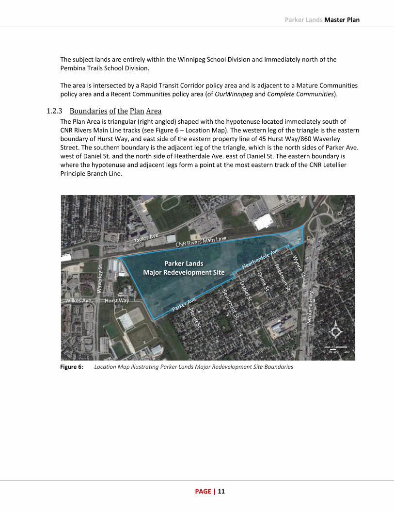
The Plan Area is triangular (right angled) shaped with the hypotenuse located immediately south of CNR Rivers Main Line tracks (see Figure 6 – Location Map). The western leg of the triangle is the eastern boundary of Hurst Way, and east side of the eastern property line of 45 Hurst Way/860 Waverley Street. The southern boundary is the adjacent leg of the triangle, which is the north sides of Parker Ave. west of Daniel St. and the north side of Heatherdale Ave. east of Daniel St. The eastern boundary is where the hypotenuse and adjacent legs form a point at the most eastern track of the CNR Letellier Principle Branch Line.
Figure 6: Location Map illustrating Parker Lands Major Redevelopment Site Boundaries
Parker Lands Master Plan
PAGE | 12
1.2.4 Surrounding the Plan Area
The Plan Area is within a 1 to 5 km proximity of other nodes and corridors identified in OurWinnipeg as important to meeting Winnipeg’s growth projections to 2031:
Major Redevelopment Site ‘E’, Fort Rouge Yards at 18 acres with the Yards at Fort Rouge Master Plan endorsed by Council on December 15, 2010. It is being redeveloped as high density residential with a mixture of housing types. It is to the immediate north east of the Parker Lands on the north east corner of the Pembina Highway / Jubilee Avenue overpass on the Southwest Bus Rapid-Transit Corridor, Stage 1.
Major Redevelopment Site ‘F’, the Taylor Lands at 48 acres with the Taylor Redevelopment Master Plan endorsed by Council May 29, 2013. It is being developed as Grant Park Pavilions with commercial retail and services, employment, and residential land-uses on the south side of Taylor and to the immediate north of the CNR Rivers Main Line which bisects the Taylor Lands from the Parker Lands. Manitoba Hydro’s former head office at 820 Taylor Avenue with Hydro Sub-Station is also located to the immediate north of CNR Rivers Main Line as well as the Grant Park Festival with a current multi-tenant commercial land-use.
The existing Beaumont Neighbourhood (1.602), directly south of Parker/Heatherdale Avenues, and the east-west MB Hydro Corridor, is identified as a ‘Mature Community’ in Complete Communities with a full range of municipal services. Beaumont is predominantly single-family dwellings with 91.9 percent of the dwellings constructed prior to 1980; 91.5 percent (865) of the dwellings (945 total) being single-family; and 90.4 percent are ‘owner occupied’ (2011 Census). Beaumont’s eastern boundary is Pembina Hwy, which is identified as a Regional Mixed Use Corridor ‘F’, a ‘Transformative Area’ with commercial land-uses such as gas bar, restaurants, personal services and some medium to high density housing.
To the southwest of the Parker Lands across the MB Hydro Corridor is the Buffalo Industrial Neighbourhood (1.652) ‘Employment Lands’ with land-uses such as warehouses, distribution centres, head offices; and the City of Winnipeg’s waterworks W.D. Hurst Station and Ralph Cantafio Soccer complex.
Further south from the Plan Area along the Southwest Bus Rapid-Transit Corridor, Stage 2 is Major Redevelopment Site ‘H’ Sugar Beets Lands at 131 acres with the Bishop Grandin Crossing endorsed by Council on May 13, 2014 for a mixture of employment, commercial and residential land-uses.

Parker Lands Master Plan
PAGE | 13
Figure 7: Context Map

Parker Lands Master Plan
PAGE | 14
1.2.5 Existing Land-Use in and Around Plan Area
More than half of the Parker Lands is currently underutilized, not-in-use, open spaces covered by vegetation. The privately owned and developable land within the Parker Lands is bounded to the south by a wide field occupied by Manitoba Hydro infrastructure and power lines. A portion of this field had been used as the site of the Brenda Leipsic Park (on approximately 18 acres), which included an off-leash dog area. This property is owned by Manitoba Hydro and the City of Winnipeg, and will also be the site of the future Southwest Bus Rapid-Transit Corridor, Stage 2.
Figure 8: Existing Land Use Map

Parker Lands Master Plan
PAGE | 15
Outside of the Parker Lands, to the south of the Hydro Corridor, is a large area of single-family dwellings in the Beaumont Neighbourhood. This area includes amenities such as General Byng School, Fort Garry Community Centre Victoria site, several parks and play areas, a large industrial facility (CG Powers Systems Canada) and a funeral home with accessory cemetery. To the north of the Plan Area, directly across the CNR Rivers main line, there are substantial commercial, office, recreation & leisure facilities and schools in proximity to the site. This includes land recently rezoned for commercial and residential uses (Grant Park Pavilions)which has a Walmart, as well as the Taylor Festival with a Sobeys grocery store. Further beyond this to the north is the Grant Park Neighbourhood (1.604) with the Pan Am Pool, Grant Park High School, Grant Park Shopping Centre, Charles A. Barbour (Grant Park) Arena, Harrow School, as well as many single-family and multi-family residential dwellings. North-East of the Plan Area, across Pembina Hwy/Jubilee Avenue is Berwick Athletic Fields and the ‘Yards at Fort Rouge’ Transit-Oriented Development adjacent to McKittrick Park in the Lord Roberts Neighbourhood (1.665). Immediately to the west adjacent to the Plan Area are the remaining land-uses in the Parker Neighbourhood, which include the Winnipeg Humane Society, a storage locker facility, and a multi-tenant strip mall. Further west and southwest is the residential neighbourhood of Linden Woods (1.634) and the Kenaston/McGillivray Power Centre, and due west is the Seasons of Tuxedo/IKEA redevelopment of the former CNR Intermodal Yard into a mixed-use, commercial and residential hub abutting the same CNR Rivers main line.
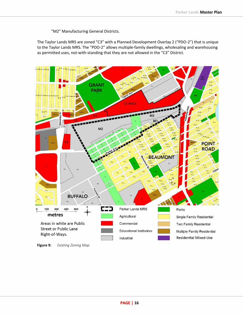
1.2.6 Existing Zoning in and Around Plan Area
Winnipeg’s Zoning By-law 200/2006 divides areas into zoning districts in order to separate residential, commercial and industrial land-uses; and to regulate specific land-uses and built forms. Zoning regulations do not apply to either unimproved or improved Public Street Right-of-Ways (ROWs) or Public Lane ROWs. An unimproved ROW means no concrete, asphalt or gravel has been laid down and the road bed remains in a natural state though legally open as a right-of-way. The Parker Lands are currently zoned as the following:
“A” Agricultural Districts; “R1” Residential Single-Family Districts; “M1” Manufacturing Light Districts; and “M2” Manufacturing General Districts.
M1 and M2 districts are intended to provide for light manufacturing, processing, service, storage, wholesale, and distribution operations, with some limited outside operations and storage. The Parker Lands are also abutting or near the aforementioned zoning districts and:
“C2” Commercial Community Districts; “C3” Commercial Corridor Districts; “PR1” Parks and Recreation 1 (Neighbourhood) Districts; “PR2” Parks and Recreation 2 (Community) Districts; “PR3” Parks and Recreation 3 (Regional) Districts; “M1” Manufacturing Light Districts; and
Parker Lands Master Plan
PAGE | 16
“M2” Manufacturing General Districts. The Taylor Lands MRS are zoned “C3” with a Planned Development Overlay 2 (“PDO-2”) that is unique to the Taylor Lands MRS. The “PDO-2” allows multiple-family dwellings, wholesaling and warehousing as permitted uses, not-with-standing that they are not allowed in the “C3” District.
Figure 9: Existing Zoning Map
Parker Lands Master Plan
PAGE | 17
1.2.7 Existing Features
Starting from the northwest corner of the site, the CNR Rivers main line rail tracks run west to east through Portage Junction towards the CNR Fort Rouge Rail Yards approximately 1km northeast of the site. The tracks are at-grade with a slightly higher profile than the surrounding terrain. Immediately adjacent to the CNR main line to the south is a service road in use by CNR. There appears to be a slight high point in the tracks approximately mid-point of the site.
Major overhead electrical infrastructure crosses the middle of the site on towers and poles on a north/south tangent (See Figure 8 - Existing Land Use map). A line of poles at the centre and south of the site can be observed running in a westward direction turning south before reaching Hurst Way down a hydro corridor. It is generally understood that the tower infrastructure is transmission, while lines on poles are local distribution. Within the hydro corridor the entire parcel appears to be maintained such that grasses are allowed to grow to a height of approximately six inches during the summer months. The centre and east side of the Parker Lands is currently under construction with the excavation of a storm retention basin and roads for the second leg of the Southwest Rapid Transit Corridor. An off-site communication tower can be seen further to the east and is a dominant feature. The Pembina Highway/Jubilee Avenue underpass, which is also under construction, is due east of the site. Parker Avenue is the northernmost roadway of the Beaumont Neighbourhood to the south which contains mostly single family dwellings. Just north of that is Heatherdale Avenue which is a gravel back lane.
1.2.7.1 Existing Forest
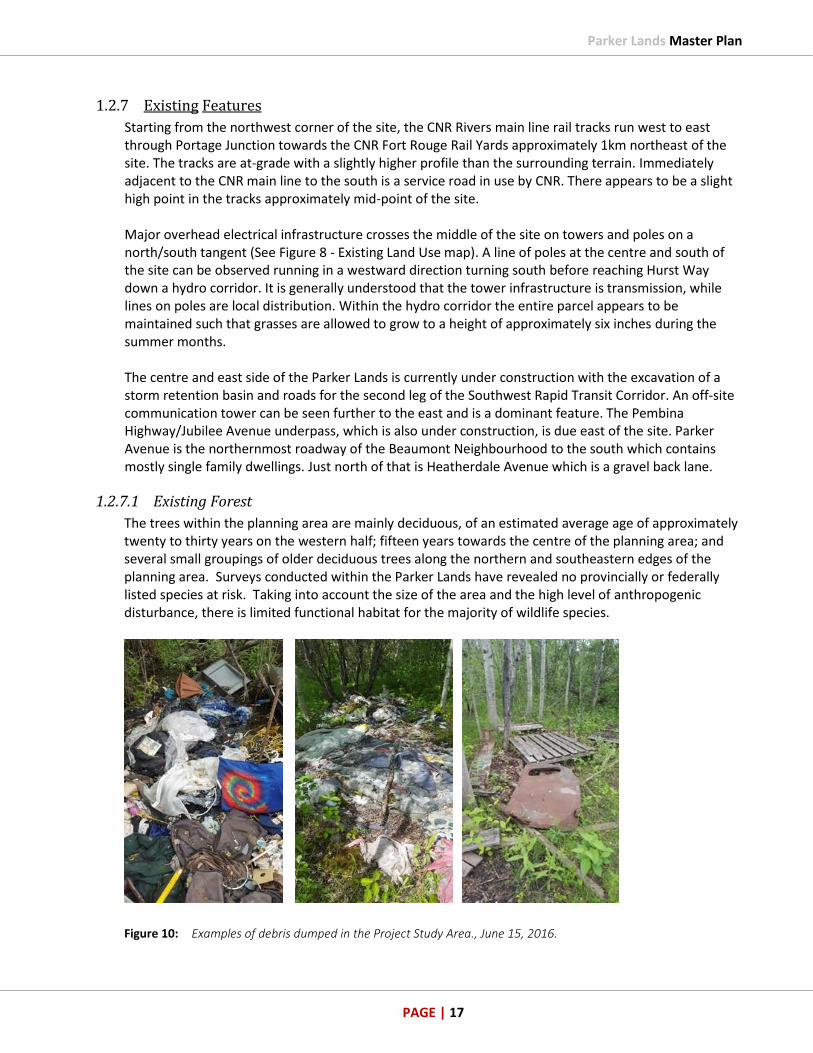
The trees within the planning area are mainly deciduous, of an estimated average age of approximately twenty to thirty years on the western half; fifteen years towards the centre of the planning area; and several small groupings of older deciduous trees along the northern and southeastern edges of the planning area. Surveys conducted within the Parker Lands have revealed no provincially or federally listed species at risk. Taking into account the size of the area and the high level of anthropogenic disturbance, there is limited functional habitat for the majority of wildlife species.
Figure 10: Examples of debris dumped in the Project Study Area., June 15, 2016.

Parker Lands Master Plan
PAGE | 18
In March, 2017 the City of Winnipeg began removing a small oak forest within the planning area to clear a path for the second leg of the transit way corridor and active transportation pathway.
There are several foot trails on the private landowner’s site that have evolved from recreational uses. As part of the intensive environmental survey work conducted by biologists who studied the Plan Area (an Environmental Overview report by EcoLogic Environmental Inc. can be found in Appendix B), it was noted that the site had been heavily used with a matrix of human and dog walking trails throughout the footprint of the site creating an extensive pathway system. An additional report was conducted by biologists to determine the effect of past and future person-use on vegetation which could be utilized as green space areas. This report can be found in 1.6 Supporting Studies. In late summer and early fall of 2017, the private land owners removed some trees from the west and central part of the planned area to prepare for geotechnical drilling and surveying as part of the planning work for the privately-owned lands. Prior to any tree removal, the site was investigated by biologists for bird species at risk and breeding bird activity nesting sites. This Pre-Clearing Breeding Bird Survey Report was completed in June, 2017 and outlined the methods used for the Pre-Clearing Breeding Bird Survey work as well as the results of the survey (for full report see 1.6 Supporting Studies). There were eight nests identified within the specified area of the Parker Lands during the Pre-Clearing Breeding Bird Survey, of which only three were determined to be active nests. A 50 metre clearing restriction buffer was recommended for an active Coopers Hawk nest until such time as the chick within the nest had successfully fledged. No migratory birds or bird species at risk nests were identified in the Parker Lands, therefore no tree clearing activity restriction buffers were required.
1.2.7.2 Topography
The site is of relatively flat topography and had been vegetated with a combination of grasslands and trees. As of summer 2017, the grasslands and some of the trees were removed to reshape the site. Most of the remaining trees on site are deciduous with several small groupings of older deciduous trees along the northern and southeast edges of the site. There were some low-lying areas on the northern part of the Plan Area. Through the spring and summer months, there were tall grasses and cattails evident in the low-lying areas, consistently immersed in several inches of standing water from poor drainage conditions. A low ridge sets apart the eastern low area from the rail lines to the north. The CNR Rivers main line is approximately 1.5 metres above the lowlands and grassed area between the Hydro towers. A naturalized Stormwater Retention Basin (SRB) is being constructed on the eastern half of the Plan Area. The edge of the SRB will be planted with native plantings, which provide similar functions to natural wetlands. With large expanse of water and naturalized edge, the SRB will potentially be similar to a Class V Wetland.
1.2.7.3 Soil Profile
Soil composition is Glacial Lake Agassiz clay of the Pleistocene era. Bedrock is Palaeozoic carbonate: limestone and dolomitic limestone, inferred at 15.5 to 21.3 m below ground surface. The nearest open body of water is the Red River, approximately 650 m to the east of the property. Groundwater is inferred to follow this direction to the river.

Parker Lands Master Plan
PAGE | 19
1.2.8 Environmental Assessment / Contaminated & Impacted Sites
As a portion of the site was a former rail yard, there is a possibility that environmental contamination may be present. The portion of the site which was used as a rail yard is the northern boundary on the northeast quadrant of the site (part of where the future storm retention pond will be). This would fall under the jurisdiction of the Province of Manitoba’s Contaminated Sites Remediation Act (CSRA). Manitoba Conservation is the responsible agency for ‘contaminated’ and ‘impacted’ sites under the act and is the agency which provides oversight on remediation if required. Pinchin Environmental Ltd. (Pinchin) carried out a Phase I Environmental Site Assessment (ESA) for the site in October, 2010 and for additional land in January, 2015 (see 1.6 Supporting Studies). In their reports, Pinchin noted that based on review of documentation in the Manitoba Archives and previous environmental reports nothing was identified that is likely to give rise to potential subsurface impacts in connection with the Site. However, with regards to the north eastern portion of the site, Pinchin noted that a rail yard operation with several spur lines could be observed on that portion of the site in the 1948 and 1959 aerial photographs. Due to this, it could give rise to potential subsurface impacts in connection with the site.
Based on the findings noted above, Pinchin recommended completing a Phase II ESA of the site for the northeast portion of the Plan Area. Dillon Consulting provided recommendations for a Phase II ESA (see 1.6 Supporting Studies). Dillon concluded that a Phase II ESA was not necessary, for the following reasons:
The exposure pathway for the types of impacts associated with former rail operations is incidental soil ingestion or dust inhalation;
An effective way to manage this risk is through a ground surface cover, or cap, that acts as a separation barrier keeping any material below the surface;
Incorporating a cap has been demonstrated as a cost-effective approach and has been tested in numerous industrial properties, including former rail operations;
This approach has been adopted on a similar redevelopment that creates the Yards at Fort Rouge;
This approach is acceptable to Manitoba Conservation as an effective means of managing exposure risk associated with surgical soil impacts.
Accordingly, the assessment studies for this site do not call for environmental remediation beyond the provision of a ground surface cover if necessary, as recommended by Dillon.

Parker Lands Master Plan
PAGE | 20
1.2.9 Existing and Planned Infrastructure & Services
Figure 11 below shows the existing Water, Waste Water and Land Drainage infrastructure services in and around the Plan Area.
Figure 11: Existing Infrastructure and Site Services Map
1.2.9.1 Existing and Planned Water Infrastructure
As indicated by site records, a 250 mm water main crosses the west side of the site on a north/south alignment with the unimproved Cooney Street Right-of-Way (see Figure 11 – Existing Infrastructure and Site Services Map). A Feeder main crosses through the southwest corner of the site, perpendicular to Parker Avenue and then turn 90 degrees west directly down the Hurst Way Right of Way towards Waverley.

Parker Lands Master Plan
PAGE | 21
1.2.9.2 Existing and Planned Land Drainage Infrastructure
1) Land Drainage Natural drainage on the site generally runs in an eastward direction towards the Red River. The CN rail tracks on the north boundary limit the migration of water to the north. The area of the developable land on site is currently undergoing a significant increased elevation change with the final grading holding drainage on site but generally draining in an easterly direction. Recent infrastructure upgrades on city and hydro lands have directed drainage in an easterly direction and contained drainage within those lands. A naturalized Storm Retention Basin (SRB) is currently being constructed on the eastern area of the site to accommodate drainage from the Parker Lands and other neighbouring communities. 2) Combined Sewers The area surrounding the Parker Lands site falls within the Cockburn & Calrossi combined sewer districts (Cockburn West). Work to the north and east began in 2011 to relieve the combined sewers and improve existing services. This work is scheduled to take around 5 to 7 years to complete. An outfall to the Red River was constructed in 2014 and pipes from the future retention pond to the outfall on the Red River started to be installed in the summer of 2017.
The intersection at Parker Avenue and Wynne Street will be the location of the Waste Water connection point for future development in the Parker Lands as provided by the City Public Works department. This is the nearest location that has pipe capacity for residential development to tie in to for Waste Water services. All the pipes serving the redevelopment of the lands in the Planned Area have yet to be installed.
1.2.9.3 Existing and Planned Waste Water Infrastructure
There are no existing Waste Water pipes within the Planned Area. The nearest Waste Water pipe is in Parker Avenue, south of Heatherdale Avenue, terminating at the west side of Daniel Street, and is between 375mm to 600mm in diameter. The nearest Waste Water tie-in point is at Parker Avenue and Wynne Street (see Figure 12).
Figure 12: Parker Lands Waste Water tie-in location
Parker Lands Master Plan
PAGE | 22
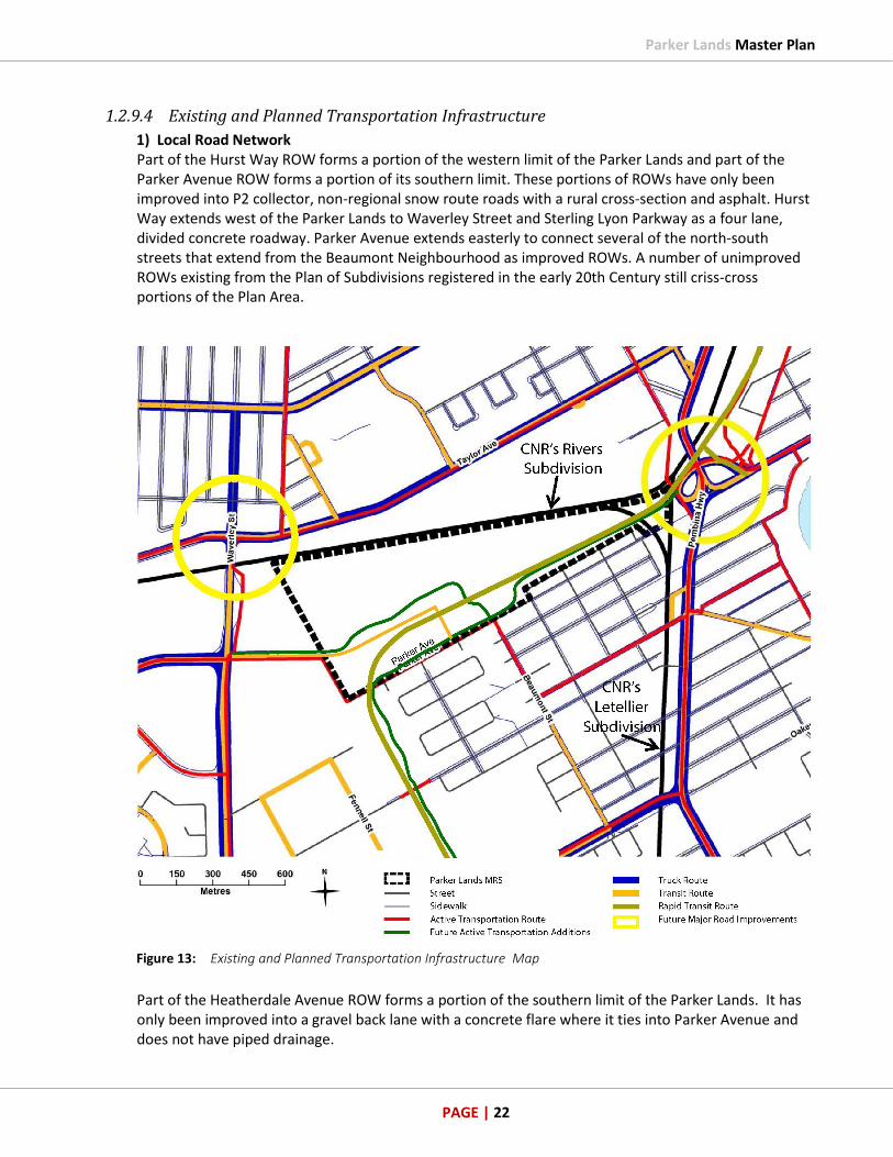
1.2.9.4 Existing and Planned Transportation Infrastructure
1) Local Road Network Part of the Hurst Way ROW forms a portion of the western limit of the Parker Lands and part of the Parker Avenue ROW forms a portion of its southern limit. These portions of ROWs have only been improved into P2 collector, non-regional snow route roads with a rural cross-section and asphalt. Hurst Way extends west of the Parker Lands to Waverley Street and Sterling Lyon Parkway as a four lane, divided concrete roadway. Parker Avenue extends easterly to connect several of the north-south streets that extend from the Beaumont Neighbourhood as improved ROWs. A number of unimproved ROWs existing from the Plan of Subdivisions registered in the early 20th Century still criss-cross portions of the Plan Area.
Figure 13: Existing and Planned Transportation Infrastructure Map
Part of the Heatherdale Avenue ROW forms a portion of the southern limit of the Parker Lands. It has only been improved into a gravel back lane with a concrete flare where it ties into Parker Avenue and does not have piped drainage.

Parker Lands Master Plan
PAGE | 23
The improved portions of the Planet Street ROW and Beaumont Street ROW extend south from Parker Avenue with the full range of municipal services, however, at their connections with Parker Avenue:
Planet Street has only been improved into a local road with a rural cross-section; and
Beaumont Street has only been improved into a collector road with a rural cross-section. The improved portions of the Daniel Street ROW and the Derek Street ROW extend south from Heatherdale Avenue but have only been improved into local roads with rural cross-sections. The Rockman Street ROW and the Wynne Street ROW only extend as far north as Heatherdale Avenue. They too have only been improved into local roads with rural cross-sections at and just south of Heatherdale Avenue. This is the only municipal transportation infrastructure near the Parker Lands and there is no other existing City transportation infrastructure in the Parker Lands. 2) Regional Road Network Regional Networks in the periphery of the study area and all Boundary intersections including Waverley Street and Taylor Avenue, Waverley Street and Wilkes Avenue/Hurst Way, McGillivray Boulevard and Pembina Highway are largely operating at overcapacity conditions during morning and afternoon rush hours, and at near-capacity conditions during off-peak hours (see Preliminary Traffic Analysis memo by Morrison Hershfield in Appendix D).
Figure 14: Existing Transportation Network
Existing traffic shortcutting along neighborhood roads is significant, ranging from about 30 percent to 50 percent of current AM and PM peak hour traffic volumes on roads such as Windermere Avenue, Beaumont Street, Parker Avenue, and Hurst Way. Existing traffic shortcutting through the neighborhood is mainly attributed to overcapacity conditions at the intersection of Waverley Street and Taylor Avenue as well as traffic disruptions and long queues at the existing at-grade CNR Rivers rail crossing at Waverley Street caused by frequent train operations. With approximately 30,000 vehicles and between 35 and 40 train movements passing through the intersection daily, the Waverley Street

Parker Lands Master Plan
PAGE | 24
rail crossing has become a major vehicle traffic bottleneck in the area (see Figure 14 – Existing Transportation Network). To alleviate most of the Waverley Street traffic delays, construction of a grade separated crossing of Waverley Street at the CNR Rivers Main Line was approved by Winnipeg City Council and began construction in 2017. The “Waverley Underpass Project” (beneath the train tracks just south of Taylor) along with capacity improvements of both Waverley Street and Taylor Avenue, and Waverley Street and Hurst Way intersections are all anticipated to be completed by Spring 2020. Significant improvements in regional traffic flows in the southwest quadrant of Winnipeg are expected as a result of all these infrastructure improvements. The Traffic Analysis suggests that the Pembina Highway Underpass upgrades as part of the Southwest Transitway Project are to improve traffic flows between Point Road and Stafford Avenue with the provision of a third north bound lane. In addition, this work will also improve pedestrian and cyclist facilities on Pembina Highway between Jubilee Avenue and Stafford Street by providing dedicated pedestrian/cycle corridors on both sides the underpass (see Figure 15 – Southwest Transitway below).
Figure 15: Southwest Transitway – Underpass Upgrades to Pembina Hwy
3) Active Transportation The City of Winnipeg Pedestrian and Cycling Strategy adopted by Winnipeg Council July 2015 identifies a citywide network concept, which seeks to connect cyclists to a variety of downtown and regional centres. The City of Winnipeg Transportation Master Plan Map for Active Transportation was also amended and includes ‘Proposed Additions to AT Network’ being identified through the Parker Lands and Beaumont Neighbourhood to connect Pembina Highway with AT facilities alongside Waverley Street. The Pedestrian and Cycling Strategy associate map for the SW Quadrant indicates a proposed Off-Street Pathway aligned with Parker Avenue.

Parker Lands Master Plan
PAGE | 25
In addition, a future regional AT path that would extend east-west through the Parker Lands (north of Hurst Way) and pass under two rail lines and over Pembina Highway is also being proposed as part of the SWRTC project. This will include future sidewalks and paths that would connect existing sidewalks in the Beaumont Neighbourhood to the regional path (see figure 15). The adjacent Southwest Bus Rapid Transit Corridor, Stage 2 will be integrated into the Plan Area as part of the design strategy to allow an additional transportation access, and reduce reliance on vehicles. 4) Public Transit Services There is currently no transit service in the Planned Area and little in the Beaumont Neighbourhood – only along Windermere, south on Beaumont and out to McGillivray Boulevard. Public transit is available near the Parker Lands within a short walking distance from the neighbourhood on Waverley Street and on Pembina Highway. Access to each of these will be improved with the introduction of the AT paths described above.
Figure 16: City of Winnipeg Transit Route Access Map
Once the new Parker Transit Station is completed just north west of Beaumont Street terminus at Parker Avenue, it is anticipated that connector buses will also travel through from Waverley Street and the Beaumont Neighbourhood, connecting up to the Southwest Bus Rapid-Transit Corridor (Stage 2) to provide direct access to other routes across Winnipeg. 5) Railway Rail lines extend through the eastern portion of the Parker Lands. The rail corridor of another rail line forms the eastern limit of the Parker Lands. These lines are principle branch lines. They connect to the CNR Letellier Principle Branch Line and the CNR Rivers Main Line. The rail corridor of the Rivers Main Line is partly in the Parker Lands (see Figure 13 - Existing and Planned Transportation Infrastructure Map).

Parker Lands Master Plan
PAGE | 26
1.2.9.5 Existing Utilities
Parker Avenue is indicative of a typical street in a mature neighborhood with overhead power lines and telephone services. Heatherdale Avenue will be the most likely route for future off-site utility connections from the proposed residential development to the north based on the Site Servicing study by InfraCor (see Appendix C) with pipes connecting at the intersection of Parker Avenue and Wynne Street to existing waste water sewer infrastructure. The existing Hydro Power Lines and Towers prominently seen in the area will be a major consideration during the design and construction of the deep utilities (see Figure 8 – Existing Land Use Map for distribution and transmission line locations). The existing Parker Tot Lot to the west of Daniel St. and the private property to the east will also be a consideration during construction.
1.2.9.6 Existing Libraries
Through consultation with City of Winnipeg departments and the General Council of Winnipeg Community Centres it has been determined that, in the Parker Land, there is no need for a new library. The nearest existing library location as displayed on the Context Map in Figure 7 is Fort Garry Library at 1360 Pembina Highway.
1.2.9.7 Existing Protective and Emergency Services
As identified on the Context Map in Figure 7, the nearest existing fire paramedic location is Winnipeg Fire Paramedic Service Station #13 on Beresford Avenue and Lilac Street (in Lord Roberts).
In addition, other locations of fire paramedic stations nearby are:
Winnipeg Fire Paramedic Service Station #12 on 1780 Taylor Ave. (Mathers Neighbourhood).
Winnipeg Fire Paramedic Service Station #22 at 1567 Waverley St. (Chevrier Neighbourhood). It has been determined that there is no need for a new fire-paramedic station in the Planning Area.
1.2.9.8 Existing Parks and Recreation Facilities
The nearest Community Centre is Fort Garry Community Centre (Victoria Site) located at 80 Derek Street in the Beaumont Neighbourhood which is about 1.7 km south of the Humane Society at 45 Hurst Way (see Figure 7 – Context Map). Other existing community centres within close proximity include:
Linden Woods Community Centre located at 414 Lindenwood Drive West which is about 2.5 km from the Humane Society;
Crescentwood Community Centre at 1170 Corydon Avenue is about 2.8 km from the Humane Society;
Fort Garry Community Centre (Hobsen Site) is located at 880 Oakenwald Avenue which is about 2.9 km from the Humane Society;
River Heights Site of Corydon Community Centre at 1370 Grosvenor Avenue which is about 2.9 km from the Humane Society;
Westridge Community Centre at 3 Marshall Crescent which is approx. 3.1 km south of the Humane Society; and
Lord Roberts Community Centre at 725 Kylemore Avenue which is about 4.0 km from the Humane Society.
Parker Lands Master Plan
PAGE | 27
Through consultation with the General Council of Winnipeg Community Centres it has been determined that, in the Parker Lands, there is no need for a new community centre in the Planning Area.
1.2.9.9 Existing Schools
The Parker Lands fall within the Winnipeg School Division, Ward 1 (see Primary and Secondary Schools Analysis in the Supporting Studies for map and review of the area schools). Schools located within this district are Brock Corydon (N-6), Grant Park High School (7-12), Harrow (N-6), J.B. Mitchell (N-6), Montrose (N-6) and Rockwood School (N-6). All of these schools, however, are to the north of the CNR Rivers mainline, which could prove difficult and dangerous for young children to walk to school due to the frequency of trains crossing. With the infrastructure improvements of the Waverley and Pembina underpass projects underway, access to these schools will be much improved with their new dedicated AT pathways under the active rail lines. Alternately, the closest public school to the Parker Lands would actually be in the Beaumont Neighbourhood (General Byng School for K-9). However, this is within the Pembina Trails School Division where the associated High School is Vincent Massey at 975 Dowker Avenue (grades 9-12 for immersion and 10-12 for English). Future discussions with these two neighbouring school districts will have to take place to determine final placement for the future students. At the time of writing, through consultation with the School Divisions it has been determined that, in the Parker Lands, there is no need for a new school.
1.2.10 Opportunities and Constraints
1.2.10.1 Opportunities
The Parker Lands can be an opportunity to support a thriving and complete community to increase residential variety and densification. The Parker Lands can promote and support the City of Winnipeg’s Housing Policy goals for including diverse housing options, universal design, and appropriate density to support infrastructure and create complete communities. Opportunities exist for:
Location - To take advantage of a site located midway between downtown and the University of Manitoba on the new Southwest Bus Rapid Transit Corridor with improved travel of buses every 3 to 5 minutes; also a proximity to existing amenities located in neighbouring mature communities (see Figure 7 – Site Influences map);
Connectivity - has been improved due to new City infrastructure projects like the Southwest Bus Rapid Transit project and associated AT pathways, the new Waverley Underpass project as well as the Pembina Underpass project;
Increased Density – provides an opportunity for a Transit Oriented Development with infill housing in a non-suburban location, leading to a decrease in Green House Gas emissions;
Improved City Infrastructure – in addition to initiatives mentioned above (SWRTC, Waverley and Pembina Underpasses, new AT pathways) the creation of a Storm Retention Basin will enhance servicing over a wider area into other neighbourhoods (not just the Planning Area).
Fulfilling Council’s policies and past decisions to repurpose the land (refer to Section 1.1.1 Policy Framework).
See Appendix F for memo from Planning Consultant on Parker Lands: Opportunities for Prairie TOD.

Parker Lands Master Plan
PAGE | 28
1.2.10.2 Constraints
At one time, the constraints for the Plan Area were the shortage of transportation connections to and within the Parker Lands resulting in a scarcity of choices. This was primarily due to a deficiency of transportation infrastructure for pedestrians, cyclists, transit and cars in and around the Planning Area. Winnipeg Council’s decision to approve +$630 million on capital projects in and around the Plan Area have greatly enhanced the connectivity of the Parker Lands with new infrastructure for pedestrians, cyclists, transit users and automobiles. Some of these projects include:
Winnipeg Transit extending the Southwest Rapid Transit Corridor Stage 2 westward from Jubilee Avenue through the Parker Lands and southward along a hydro corridor, which will increase the permeability of the Planning Area for transit users, pedestrians and cyclists.
The new east/west alignment for Hurst Way from Waverley Street will serve the Parker Station and enhance the connections directly into the Plan Area for multiple modes of transportation.
The Waverley Underpass Project will provide a divided four-lane roadway with pedestrian/cycling facilities under the CN Main line to increase connectivity and reduce wait times and traffic congestion due to delays from passing trains.
The Pembina Highway Underpass to widen the roadway and add pedestrian/cycling infrastructure with buffered bike and pedestrian lanes. This will help to provide better links for multiple modes of transportation past the MB Hydro Corridor and the CN Main line.
1.3 Interpreting the Plan
1.3.1 Authority of the Plan
Complete Communities indicates there are a number of tools for implementing the vision and goals for OurWinnipeg including Planning. A Major Redevelopment Site Master Plan is one such proactive planning tool that establishes a broad framework for the future redevelopment of a planned area. This framework is based on a community vision and includes land-use and transportation concepts with a series of policy statements that work together as a guide to implementing the vision. The framework should not be overly prescriptive, but should provide clarity and direction on a variety of land-use planning and development issues, such as servicing, to both the public and private sectors. The formulation of a Master Plan under Complete Communities is a proactive and collaborative effort between the municipality, land owners and the general public. It provides a high-level community vision with the understanding that the vision, along with the plan itself, will evolve as circumstances change over time. Accordingly, a Master Plan is both a starting point that establishes local goals and objectives; and a guide for future community development.
1.3.2 Time Frame of the Plan
This plan is future oriented and guides how the Planned Area will change over an extended period of time, through a coordinated series of purposeful public and private investment actions, building towards a common vision. The timing of these actions will be dependent on the economic conditions within Winnipeg. No specific timeframe is applied to the Plan although most of the proposed redevelopment is to occur within a 15-20 year time frame.

Parker Lands Master Plan
PAGE | 29
1.3.3 Policies, Applications and Interpretations
The Plan should be read as a whole and understood as a comprehensive vision of, and guide for the redevelopment of the Planned Area. Objectives and goals are statements provided to enhance the understanding of the associated policies. Should an inconsistency arise between an objective or goal and an associated policy, the policy shall take precedence. Where “may” is used in a policy, it is provided as a guideline or suggestion toward implementing the policy in a manner that is consistent with its purpose. In cases where the word “should” is used in a policy, the policy is intended to apply to a majority of situations. The policy may be deviated from in a specific situation where the deviation is necessary to address unique circumstances that will otherwise render compliance impractical or impossible, or to allow an acceptable alternate means to implement the policy in a manner that is consistent with its purpose. In cases where the word “shall” is included in a policy, the policy is considered mandatory. However, where actual quantities or numerical standards are contained within a mandatory policy, the quantities or standards may be deviated from provided that:
The deviation is necessary to address unique circumstances that will otherwise render compliance impractical or impossible; and
The policy is implemented in a manner that is consistent with its purpose. The policies, land-use and transportation concepts contained within the Plan recognize and maintain the existing use of land or buildings as they are currently zoned and developed in accordance with the Zoning Bylaw prior to the adoption of this Plan. Nothing in this Plan precludes current uses in the Planned Area from continuing as they may exist today, and for as long as the land owner wishes, until such time as the Zoning By-law is amended to affect the land-use rights. The intentions of the Plan polices are when a land owner wishes to change (i.e. intensify) their lands, via a rezoning, a subdivision, or a conditional use, then this intensification shall be consistent with the policies which serve to direct the changes towards the vision outlined for the Planned Area.
1.3.4 Maps
The boundaries, transportation networks and land-use policy areas shown on the maps & figures contained herein are intended to be approximate only and should be considered as such. They are not intended to identify specific locations, except where a boundary is located on an easily identifiable natural or man-made landmark such as a river, railway corridor, Hydro corridor or public right-of-way. The figures are conceptual and shall be considered flexible with respect to the precise location of land-use areas and features, however, the spatial relationship among the various land-use policy areas and transportation networks is intentional.

Parker Lands Master Plan
PAGE | 30
The indication of any proposed roads, green spaces, open spaces, services or infrastructure in policy text or on the policy maps & figures will not be interpreted as necessarily being specifically, or solely, the responsibility of the City to provide, finance or otherwise implement.
The purpose of providing figures with illustrations, photographs, drawings, and non-policy maps is to provide clarification regarding the characteristics, context, history, natural features, existing land uses and current development policies/regulations of the planned area and the surrounding areas. Should an inconsistency arise between a figure, etc. and a policy statement or policy map, the policy statement or policy map shall take precedence when and where appropriate.
1.4 Monitoring, Review and Evaluation
The Plan is intended to be a flexible document that will adjust as circumstances change within and adjacent to the planning area. Periodic review and amendment of the Plan will occur as changing market and engineering conditions affect the adjacent community and the planning area.
1.5 Amendments to the Plan
The Plan may require amendments as circumstances within or adjacent to a policy area warrant. As a (secondary plan) by-law, application to amend the Plan must be submitted to the Planning, Property and Development for review and approval by Council or it’s designate. Where appropriate, the amendment process should include public consultation.
1.6 Supporting Studies
The following studies were prepared in support of and to inform this Plan. They have contributed to the conceptual land use plan and policies of the Parker Lands Major Redevelopment Site. The supporting studies have been completed at a high level and may not be sufficiently detailed to form the basis for individual subdivision or rezoning applications. More detailed studies and/or analysis may be required at time of subsequent rezoning and subdivision. The completed supporting studies include:
History of the Site
Policy Framework Review by Richard Wintrup
Phase 1 Environmental Site Assessment (Parcel B) by Pinchin
Phase 1 Environmental Site Assessment (Vacant Land Northeast of Hurst Way) by Pinchin
Environmental Risk Management Strategy by Dillon
Pre-Clearing Breeding Bird Survey by EcoLogic
Community Park Retention Area Overview by EcoLogic
An Economic Benefits Analysis by Altus
Primary and Secondary Schools Analysis

Parker Lands Master Plan
PAGE | 31
2.1 Vision
The Parker Lands will become an area of Winnipeg that is largely transit-oriented by transforming and repurposing an underutilized vacant brownfield site adjacent to an existing community. Through private investment it will become a vibrant, environmentally, socially and economically sustainable neighbourhood. It will offer a variety of housing choices with significant densities planned out in a well-designed urban form to encourage placemaking. Multi-modal transportation connections will capitalize on existing and new major regional infrastructure public investments. A diversity of green and open spaces should provide natural and planned recreational areas. The Parker Lands will become one of the first Transit-Oriented Developments (TODs) within Winnipeg in keeping with the guidelines and vision consistent with the TOD Handbook. The proposed Southwest Bus Rapid-Transit Corridor (Stage 2) will be connected into the urban design of the planned neighbourhood allowing for easy transportation access, reduced reliance on vehicles and better management of transportation demand and parking requirements.
Figure 17: Parker Station Plaza Concept Image
A clear vision for the Parker Lands Major Redevelopment Site needs a series of principles that will be the collective goals to informing planning objectives and guide actions to make that vision a reality. The vision, principles and goals reflect the main themes that emerged from the consultation process of discussions with stakeholders and the community at-large.
2 PLANNING VISION AND OBJECTIVES

Parker Lands Master Plan
PAGE | 32
2.2 Objectives
2.2.1 Placemaking: Foster Quality Places and Identity
Creating a sense of place through urban design is important to establish a strong identity for the area for the new residents and existing visitors. Effective site designs of the Plan Area will demonstrate how the pieces fit together with appropriate land-use locations, building types, massing and orientation while establishing green spaces and open spaces distinct to the area, and provide a resilient visual identity for the new neighbourhood.
2.2.2 Connected
People will be considered in the transportation systems and their connections as will all other public open spaces in an urban design strategy to improve safety and accessibility for current visitors while balancing movements with creating a sense of place for local residents. It will mitigate and make porous at safe locations the solid physical barriers that separate the Plan Area from the surrounding community; and robustly connect green spaces/recreational areas with new and existing residential living areas.
2.2.3 Sustainability: Environmental, Social and Economic
This site will become a model for the three (3) pillars of sustainability: environmental, social and economic. The overall carbon footprint will be significantly reduced through a dense compact urban form, and by way of reduced vehicle miles travelled to nearby work, recreation, goods and services destinations especially with alternative modes of transportation. Efficient energy uses for homes and buildings will be considered in using green technology. Retaining existing wooded areas and adding new green spaces will provide habitats for animals, insects and vegetation while providing open spaces for people to connect with nature. Social networks will be strengthened through careful planning of the public realm rights-of-ways and open spaces, and providing accessibility to diverse housing choices. A dense urban environment will grow in the Parker Lands that will financially support nearby employment and commercial centres with employees and customers; and maximize public investment in regional transportation infrastructure. It is important to understand the marketplace to meet the needs of the community by taking in the consideration of growing and evolving populations; evolving consumer preferences for housing and community amenities; and overall demand for housing stocks.

Parker Lands Master Plan
PAGE | 33
3.1 General
The policy Map of the Parker Lands applies to all of the Parker Lands (see Figure 18 - Land-Use Policy Map). Land in the Parker Lands is designated as any one of the following policy areas:
Urban Neighbourhood Policy Area
Limited Use Policy Area
Rapid Transit Station Node Policy Areas
Green and Open Spaces Policy Area
Natural Lands Policy Area
Railway Corridor Policy Area
Figure 18: Land-Use Policy Map
3.1.1 General Policies
1) Development should be consistent with Crime Prevention through Environmental Design Principles and Sustainable Design Principles.
2) All advertising signs must pertain to a use, location, building or development in the Parker Lands, notwithstanding signs pertaining to public transportation infrastructure or public transit service.
3) All non-residential publically accessible developments shall be consistent with Universal Design Principles.
3 LAND-USE CONCEPT

Parker Lands Master Plan
PAGE | 34
3.2 Urban Design Policies
3.2.1 Objectives
The intention of the Urban Design Policies are to realize the vision for the Parker Lands as a dense, infill complete community connected with a choice of multi modal transportation. Part of creating a walkable community is linking streets and building designs that encourage pedestrian activities, ensures multi modal transportation choices, and integrates the Planning Area with the neighbourhoods surrounding the site by following the planning principles of sustainability, placemaking and connectivity. Also part of creating a walkable community is achieving a critical mass of people and uses in a dense urban form.
3.2.2 Policies
The specific detailed designs of site and buildings shall be determined through the Development Application process and should be implemented through the use of a variety of methods including design standards, plan approval, plans of subdivisions, development agreement, zoning agreement, or a planned development overlay. The specific detailed designs of the site and building plans may be guided by Urban Design Guidelines (see Appendix E) which shall consider the following:
1) The Urban Design Guidelines should ensure that development in the Parker Lands area is consistent with the vision and policies of the Master Plan.
2) Urban Design Guidelines should include the principles of CPTED and Universal Design. 3) Urban Design Guidelines should be ‘general’ that avoid detailed design specifics to ensure
building professionals have flexibility in designing each building and site, and avoid repetitious building designs.
4) Urban Design Guidelines may address the Urban Neighbourhood Policy Area. 5) Urban Design Guidelines for the Urban Neighbourhood Policy Area shall encourage the
residential densities required to deliver a walkable community, and the mixed-use amenities that create a sense of community.
6) The Urban Design Guidelines for the Urban Neighbourhood Policy Area should be unifying the public realm and the street network to create one overall community for the residential area.
7) Urban Design Guidelines for the Urban Neighbourhood should encourage building exteriors and site designs that facilitate pedestrian movements, and sustain multi modal transportation choices.
8) Urban Design Guidelines for the Urban Neighbourhood should allow and encourage a
diversity of building typologies. 9) The Urban Design Guidelines for the Urban Neighbourhood shall only address the exterior of
buildings and above grade site plans, and the public realm areas of right-of-ways and public
spaces.

Parker Lands Master Plan
PAGE | 35
3.3 Density
3.3.1 Objectives
The intention of the Density Policies is to implement the TOD Handbook’s “Scale of TOD” that classifies the TOD Zone for the SWBRT Parker Station as ‘Urban Neighbourhood’ TOD Type based on the regional connectivity as ‘Medium, access to Downtown’ and the frequency of the buses being every 5-15 mins.
Figure 19: Urban Neighbourhood Density Policy Map
3.3.2 Policies
1) Urban Neighbourhood Area shall be the TOD Zone, which is within the first 800 metres (1/2 mile) of the SWBRT Parker Station.
2) Net housing densities for the Urban Neighbourhood Area TOD Zone shall be 99-247 units per net hectare (40-100 units per net acre) as per the TOD Handbook.
3) Net densities shall mean the buildable area of the entire Plan Area after street right-of-ways, and the public reserves of green and open spaces have been subtracted.
4) Net housing density shall be calculated across the entire Plan Area. Net housing density shall not be calculated building by building, lot by lot, or sub-sector by sub-sector. Rather Net housing density shall be calculated as the mean average density for the entire Plan Area.
5) Net housing densities in the Urban Neighbourhood Area shall be greater than the Net housing densities of the adjacent Beaumont Neighbourhood.
6) Residential densities shall radiate out from the Rapid Transit Station with ‘density’ being in an inverse relationship to ‘distance’; as the distance from the Rapid Transit Station increases, the density shall decrease.
7) A concentration of residential densities should be within 400 metres (a 5-minute walk) of the Rapid Transit Station.
8) Residential densities shall not exceed the capacity of the required infrastructure services of waste water sewer, land drainage, and water.

Parker Lands Master Plan
PAGE | 36
3.4 Parking Policies
3.4.1 Objective
The intention of the Parking Policies are to minimize vehicle miles travelled, decreasing Green House Gases; reduce commuting times and stress on the environment; and lower energy requirements for transportation due to reduced automobile usage. The policies will also encourage more usage of public transport, walking & cycling which meets the principles of sustainability, placemaking and connections.
3.4.2 Policies
Parking Requirements The detailed design, location and number of automobile parking and bicycle stalls that will be associated with the Residential Areas shall be determined through the Development Application process and should be implemented through the use of a variety of methods including design standards, plan approval, development agreement, zoning agreement, Zoning By-law, and/or a planned development overlay. The Parking Policies considerations are the following:
1) Parking should be consistent with the core principles of the City of Winnipeg TOD Handbook for Innovative Parking Strategies:
(a) Parking provided on an area basis (i.e., shared uses) rather than building by building.
(b) Reduced parking requirements through zoning by-laws such as parking maximums.
(c) Parking facilities located behind buildings, in parking structures with ground floor retail, and screened from adjacent land uses.
(d) On-street parking on all streets except limited access arterials. (e) Parking design integrated with the development to relate to the streetscape and
circulation routes. (f) Paid parking or time-limited free parking.
2) Preferential parking nearest front entrances of buildings should be given for bikes, hybrids/electric vehicles and car shares.
3) One parking space per unit for residential uses, or such other parking ratio as may be determined under the development application to reduce the size of on-site surface parking areas shall be encouraged.
4) High-quality landscaping in surface parking areas should be provided. 5) Cycling infrastructure in multi-family residential buildings may include a washing station,
repair station, and indoor bike parking. 6) Bike parking may include space for trailers and cargo bikes, which are bigger than the
standard bikes. 7) A mixture of outdoor, short-term bicycle parking; and indoor, long-term bicycle parking shall
be provided in Urban Neighbourhood Policy Areas and near the Parker Station BRT. 8) Outdoor, short-term bicycle parking lock-ups in all Policy Areas, where possible, should be
encouraged to enable cycling to and within the Planned Area. 9) Motor vehicle parking shall be considered on an area-wide basis instead of building-by-
building to allow consolidation of motor vehicle parking in fewer lots and shared parking by different users at different times of the day.
10) If the redevelopment is phased, a phasing plan may be produced that identifies all current and future parking requirements; encourages parking areas to be constructed incrementally

Parker Lands Master Plan
PAGE | 37
to match land-use build-out schedules; and supports temporary sub-standard parking ratios when the timing of land-use build-out exceeds the timing of parking area build out.
11) Bicycle parking shall be considered on an area-wide basis instead of building-by-building to allow consolidation of bicycle parking in central locations with shared amenities.
12) Secured bicycle parking associated with residential uses shall be centrally located in close proximity to the residential uses.
13) Outdoor, ground level, open-air motor vehicle parking lots should be discouraged from being located along public pedestrian/cycling routes in Residential Areas.
14) Parking facilities located underground or above ground in structures with the facilities designed to avoid blank walls along pedestrian/cycling routes, and with direct pedestrian connections to higher density uses shall be encouraged.
15) Demand for motor vehicle parking should be monitored as the Plan Area redevelops the lands, and revise motor vehicle parking requirements to align with observations so as to size the parking requirements realistically to match the automobile usage rates.
16) Guidelines as a companion for the master plan for the cycling parking program detailing specific materials, location, directional signage, and type of cycling lock-up infrastructure for both short-term and long-term bicycle parking may be generated to provide more detail direction.
3.5 Urban Neighbourhood Policy Area
3.5.1 Objective
The intention of the Urban Neighbourhood Area policies is to transform and repurpose the Parker Lands into a TOD neighbourhood with medium access to downtown, a diversity of housing choices and significant densities to support a commercial zone which meet the principles of sustainability, placemaking and connectivity.
3.5.2 Policies
1) Community and neighbourhood-scale commercial, institutional and educational uses; and residential dwellings shall be allowed within the first 400 metres (1/4 mile) of the Rapid Transit Station.
2) All types of residential dwellings and public open spaces shall be allowed within the first 800 metres (1/2 mile) of the Rapid Transit Station.
3) Nothing in the policies of this plan shall preclude ‘home occupations’; secondary suites or live-work land-uses from being allowed in single-family or multiple family type dwellings.
4) Urban Neighbourhood Area shall provide pedestrian and cycling linkages to the Rapid Transit Station.

Parker Lands Master Plan
PAGE | 38
3.6 Limited Uses Policy Area
3.6.1 Objectives
The purpose of the Limited Use Policy Area is to designate lands to be retained for existing and future major infrastructure and restrict new residential structures from being erected. These areas can meet the principles of sustainability, placemaking and connectivity by becoming opportunities for recreational and leisure uses that are compatible with major infrastructure while providing a natural buffer between the Southwest Bus Rapid-Transit Corridor, and existing and future residential areas.
3.6.2 Policies
The detailed design and locations of the Limited Use Policy Area shall be determined through the Development Application process and may be implemented through the use of a variety of methods including design standards, plans of subdivision, plan approval, development agreement, zoning agreement, Zoning By-law, and/or panned development overlay. The Limited Policy Areas considerations are the following:
1) Residential land-uses are not permitted within the Limited Uses Policy Area. 2) Passive recreational uses that serve the needs of surrounding neighborhoods shall be
encouraged. 3) Existing and intensified Hydro infrastructure may accommodate outdoor public recreational
and leisure activities by judicious layout of public spaces, programming of uses, and landscape design [with permission from Manitoba Hydro as appropriate].
4) Group activities and other recreational activities not feasible or desirable in other neighbourhood park facilities, including a designated off-leash dog park and farmers markets shall be encouraged, provided they are compatible with existing and future infrastructure.
5) Non-accessory motor vehicle parking associated with the Southwest Bus Rapid-Transit Corridor may be enabled as an acceptable land-use within Limited Uses Policy Areas.
6) Non-accessory motor vehicle parking may be encouraged to develop with gravel surfacing when and where warranted.
7) A mixture of outdoor, short-term bicycle parking; and indoor, long-term bicycle parking may be provided within Limited Uses Policy Areas near the Parker Station BRT.
8) Linkages through the area that are compatible with infrastructure (i.e. Hydro Power Lines, Stormwater Retention Basin, and Southwest Bus Rapid-Transit Corridor) shall be encouraged.
9) Electricity distribution and transmission, communications, water, wastewater, land drainage and transportation infrastructure shall be allowable.
10) Other uses that shall be encouraged include passive park space, such as recreational paths, and playgrounds provided they are compatible with existing and future infrastructure.
11) Manitoba Hydro’s Land and Property Secondary Use Application process should be undertaken in the future to determine the potential treatment of the Hydro Corridor lands.
12) Native or ornamental planting should buffer incompatible uses or softens hard edges along railways, highways, parking, etc.
13) Public use facilities (including off-leash dog parks, transit station, and recreational active transportation paths) are to be buffered from infrastructure facilities in a manner consistent with current practice.

Parker Lands Master Plan
PAGE | 39
3.7 Rapid Transit Station Node Policy Area
3.7.1 Objectives
The purpose of this policy area is to designate nodes within the Limited Uses policy area for the creation of neighbourhood focal points that will act as viable, people friendly, urban spaces such as plazas and squares. These nodes will create an enduring sense of place and connect the future SWRTC station to areas designated residential and mixed-use. In addition to being an important component of the non-motorized pathway network, this node could be a focal point for the community, with a variety of uses throughout the year that is safe and accessible public space that can be used day or night. This meets the principles of sustainability, placemaking and connections.
3.7.2 Policies
The detailed design and locations of the Rapid Transit Station Node Policy Area shall be determined through the Development Application process, and should be implemented through the use of a variety of methods including design standards, plan approval, development agreement, zoning agreement, Zoning By-law, and/or a planned development overlay. The Rapid Transit Station Node Policy Areas considerations are as follows:
1) A portion of the Limited Use Policy Area may be designated as a ‘Rapid Transit Station Node’ in accordance to the development of the BRT Station, and in location(s) with a high degree of visibility and public access, such as adjacent to one or more pathways or sidewalks that is a route to-and-from Urban Neighbourhood Areas.
2) Flexible Public Space designed for a diversity of temporary/seasonal uses and events shall be encouraged.
3) The highest quality public space within the TOD area, with special attention to pedestrian amenities, accessibility, and adjacency to private and civic uses shall be encouraged.
4) Transportation links between the residential areas and the BRT station shall be provided. 5) Public spaces of appropriate size and design may be created to accommodate seasonal uses
and special events. 6) Paved pathways shall link the BRT station and Urban Neighbourhood policy areas. 7) Sufficient nighttime lighting that is oriented to pedestrians should be provided. 8) Development of this policy area shall be compatible with existing and future electricity,
communications and transportation infrastructure. 9) Design should allow for temporary uses such as a farmers’ market, fundraising/special event
and seasonal sales should also be allowed in this policy area. 10) Pathways should connect to the regional Active Transportation network, existing and future
residential land-uses in the Parker Lands and in the Beaumont Neighbourhood. 11) The City should use this Policy Area to consider the incorporation of art into the public
spaces by committing to the incorporation of public art in major public work initiatives such as the Parker BRT Station; and by developing programs to exhibit temporary art in existing public spaces near the Parker BRT Station.
12) This Plan shall not be interpreted so as to direct, or in any way limit, transit operations occurring on the Southwest Bus Rapid Transit Corridor (Stage 2). Rather, it is intended to ensure residential land-uses shall be appropriately buffered from transit operations.
13) Non-accessory and accessory motor vehicle parking shall be discouraged within the ‘Rapid Transit Station Node’ of the Limited Uses Policy Areas.
14) A mixture of outdoor, short-term bicycle parking; and indoor, long-term bicycle parking may be provided within the ‘Rapid Transit Station Node’ near the Parker Station BRT.

Parker Lands Master Plan
PAGE | 40
3.8 Green and Open Spaces Policies
3.8.1 Objective
The intention of the Green and Open Spaces policies below is to realize the vision for Parker Lands as a vibrant neighbourhood with a diversity of well-connected publicly owned active open spaces, following the planning principles of sustainability, placemaking and connectivity. The Green and Open Spaces provide lively public areas in a safe context that complement urban living: play areas for children, off-leash dog runs for pet owners, sitting areas for seniors, walking networks for neighbourhood connectivity, and temporary events to celebrate the seasons. Vibrant Green and Open Spaces are places where people want to be, be seen, and/or meet others.
They can include well landscaped parks, playing fields, urban plazas, public squares, or similar built up areas that are gathering places for people, which can become the centre of community life. Green and Opens Spaces can also have pop up events and temporary infrastructure, food kiosks, cafés and restaurant land-uses, including outdoor dining areas, to animate public spaces with transportation connections that strongly integrate these ‘outdoor rooms’ into the surrounding community.
3.8.2 Policies
The detailed design and location of Green and Open Spaces shall be determined through the Development Application process and should be implemented through the use of a variety of methods including design standards, plan approval, plans of subdivision, development agreement, zoning agreement, Zoning By-law and/or a planned development overlay. The Green and Open Spaces design and location considerations are the following:
1) Green and Open spaces shall only be established within the Urban Neighbourhood Policy Area, Rapid Transit Station Node Policy Area, Limited Use Policy Areas, and the Railway Corridor Policy Areas.
2) The Urban Neighbourhood Policy Area shall have at least one Green and Open Space that shall be centrally located to ensure inclusivity and optimize use for local residents.
3) Green and Open spaces should be located within, adjacent or abutting residential land-uses to enable residents a comfortable walk to and through their community.
4) Green and Open spaces in Urban Neighbourhood Policy Area should be a unifying public realm, part of the open space, and street network that creates one overall community for the residential area.
5) Green and Open spaces shall have strong sight lines to encourage ‘eyes on the street’ critical to community safety.
6) Green and Open spaces should be constructed in accordance with CPTED and Universal Design principles.
7) There should be a diversity of Green and Open spaces in the Planning Area with different functions and facilities to accommodate an assortment of activities.
8) Each Green and Open space should have a clear function, character and shape with well-defined boundaries through the positioning of adjacent buildings, walls, fences, trees and plantings.
9) Green and Open spaces should have lighting, directional signage, focal points and connect to the cycling and pedestrian networks of the Planning Area.

Parker Lands Master Plan
PAGE | 41
10) Green and Open spaces may have a variety of vegetation plantings such as flowers, trees and/or shrubs along with boxes and plots for community gardening.
11) Green and Open spaces should provide seating areas that allow people to rest and observe surrounding activities.
12) Amenities such as water features, clock towers, public art and/or architectural features may be considered as landmarks in Green and Open spaces that provide identity to the neighbourhood.
13) Café, restaurants, food trucks, food kiosks, eating and drinking land-uses and outdoor dining and drinking areas should be encouraged.
14) Children play areas, playgrounds, community gardening, pop up activities, off-leash dog runs, organized recreational games, leisure events, outdoor art and music events, seasonal and temporary events should be land-uses that are encouraged.
15) Accessory motor vehicle surface parking and bicycle parking (short and long term) may be enabled as an acceptable land-use within Green and Open Spaces Policy Areas.
16) Collaboration with Manitoba Hydro to identify opportunities to accommodate passive leisure and recreational uses in the Hydro Corridors of the Limited Use Policy Areas as appropriate should be encouraged.
17) Collaboration with the private sector to identify opportunities to accommodate in Green and Open Spaces, cafés, restaurants, food trucks, food kiosks, eating and drinking land-uses and outdoor dining and drinking areas should be encouraged.
18) Green and Open spaces shall be connected to existing pathways or sidewalks to facilitate easy pedestrian and cycling movements.
19) Regional pathways may connect to and through Green and Open Spaces. 20) Green and Open spaces should provide at least one universally accessible path that
connects to one or more existing adjacent path or sidewalks.
3.9 Natural Lands Policy Area
3.9.1 Objectives
The intention of the Natural Lands is for designating some areas within the Planning Area for retention as passive publicly owned public spaces that reflect their existing features such as grassy areas, woodlots and/or natural topography, which meets the principles of sustainability, placemaking and connections. Natural Lands should remain relatively ‘as is’ since Green and Opens Spaces will provide the active spaces for the public.
3.9.2 Policies
The location of Natural Lands shall be determined through the Development Application process and may be implemented through the use of a variety of methods including land dedication, plans of subdivision, development and zoning agreements, Zoning By-law and/or a Planned Development Overlay (PDO). The Natural Lands design and location considerations are as follows:
1) Natural Lands Areas may be within the Limited Use Policy Areas, Green and Open Space Areas and the Railway Corridor Policy Areas.
2) There shall be minimal modifications to Natural Lands Area in order to maintain the passive character of these lands.
3) Natural Lands Areas may not necessarily be publicly accessible by streets, sidewalks or pathways
Parker Lands Master Plan
PAGE | 42
4) Motor vehicle and bicycle parking may be enabled as an acceptable land-use that serves a Natural Lands Area.
5) Passive, low-impact public facilities for seating, cycling and walking may be facilitated; and when occurring should be constructed in accordance with CPTED and Universal Design Principles.
6) The exact boundaries and location of any Natural Lands Area shall be established through a Development Application planning process and until such time, all existing land-use tenure and rights remain in place.
3.10 Railway Corridor Policies
3.10.1 Objectives
The intention of the Railway Corridor policies is ensure the continued operations of the existing railways without impediments while providing adequate safety measures for the new residents. The policies achieve this by providing a clear outline on the method and process for determining what is considered as the appropriate edge treatment for the new habitable dwellings being located in close proximity to the rail lines at this specific area.
3.10.2 Policies
The detailed design of the edge treatment including the setback between the rail corridors and Urban Neighbourhood Areas shall be determined through the Development Application process, and should be implemented through the use of a variety of methods including design standards, plan approval, development agreement, zoning agreement, Zoning By-law, and/or a planned development overlay. The Guidelines for New Development in Proximity to Railway Operations, 2013 (NDPRO) by the Federation of Canadian Municipalities is a reference document to be used. In meeting the principle of inclusion, the Railway Corridor Policies considerations are as follows:
1) New residential dwellings adjacent to existing rail corridors shall be carried out consistently with the recommendations of a qualified engineer following ‘best practices’ as provided in the NDPRO; and in consultation with CNR for their Main and Principle Branch Lines.
2) This Plan shall not be interpreted so as to direct, or in any way limit, railway operations occurring on railway lands. Rather, it is intended to ensure residential land-uses shall be appropriately buffered from railway operations.
3) ‘Residential’ land-uses in the context of the Railway Corridor Setback should not preclude allowing motor vehicle parking, bicycle parking, landscaping, accessory structures (except those with a secondary suite), porches, carports, aviaries, swimming pools, hot tubs, open decks, landings, staircases, gazebos, seating areas, canopies, balconies, porticos, sunrooms, Green and Open Spaces, garbage enclosures, and temporary construction trailers or buildings from being established within the established Urban Neighbourhood Area setback for a rail corridor.

Parker Lands Master Plan
PAGE | 43
The following section will present more specified objectives and policies that will guide the changes for the Parker Lands in a manner consistent with the planning principles, and designed to achieve the vision for the Parker Lands as a dense, vibrant and viable neighbourhood adjacent to a mature community as illustrated in the transportation and servicing concepts.
4.1 Transportation Infrastructure
4.1.1 Objectives
Ensure publicly accessible, safe, functional, efficient and convenient transportation networks are provided to pedestrians, cyclists, public transit users and motorists, which are consistent with principles of TOD and meet the principles of this plan of sustainability, placemaking and connections.
Figure 20: Transportation Network
4 TRANSPORTATION AND SERVICING POLICIES

Parker Lands Master Plan
PAGE | 44
4.1.2 Policies
The detailed design & location of transportation routes & networks including public ROWS shall be further refined and determined through the Development Application process and should be implemented through the use of a variety of methods including plans of subdivision, design standards, plan approval, development agreement, zoning agreement, or a planned development overlay. The transportation infrastructure designs and locations considerations are as follows:
1) Transportation networks that connect a variety of travel modes to destinations in the Parker Lands, shall be provided and shall connect to the adjacent regional transportation infrastructure to allow movements to external destinations.
2) Efficiently and effectively the Planned Areas’ transportation network shall connect pedestrian, cycling, public transit and vehicular modes of travel by:
(a) Creating coherent pedestrian networks encouraging access from new residential areas to the Rapid-Transit Station, the regional path, destinations in the Parker Lands and adjacent pedestrian infrastructure;
(b) Accommodating a regional path for Active Transportation adjacent to the Southwest Bus Rapid-Transit Corridor;
(c) Connecting cyclist routes to one another and to the regional path; (d) Providing roadways necessary; (e) Accommodating opportunities for a variety of convenient commuting options from
and through the Planned Area; (f) Orientating vehicular access and egress towards collector and arterial streets, where
possible, to prevent traffic infiltration on adjacent residential local streets. 3) A pedestrian and cycling network on private lands should be designed that complements
and connects to the public transportation network of the surrounding community. 4) Cycling as a mode of transportation shall be encouraged through the provision of cycling
infrastructure; including paths, roads, and traffic control devices and secure bicycle parking facilities especially in close proximity to the Rapid-Transit Station.
5) The alignment of a transportation routes shall avoid fragmenting land into areas that are not suitable for their intended uses.
6) Vehicular transportation networks shall accommodate on-street motor-vehicle parking on most roads (which does not include driveways or back lanes) unless safety concerns or loading needs suggest otherwise.
7) Vehicular transportation networks shall include roads, back lanes, driveways and parking and loading/unloading facilities.
8) At-grade direct private motor vehicle access to the Southwest Bus Rapid-Transit Corridor (Stage 2) shall not be permitted except at controlled crossings.
9) At-grade direct pedestrian or cycling access to the Southwest Bus Rapid-Transit Corridor (Stage 2) shall not be permitted except at controlled crossings.
10) As required, emergency or temporary access to the developing portion of the Planned Area shall be identified at the Development Application stage, and maintained in a satisfactory manner until such time as the permanent road network is developed.
11) Wherever possible, pedestrian and cycling should be located within or integrated with a park or natural feature (including the linear parkway and storm water management areas).
12) The Transportation Network for the planning area shall be designed to adequately and efficiently serve the ultimate buildout of the development.

Parker Lands Master Plan
PAGE | 45
4.2 Water, Waste Water and Land Drainage
4.2.1 Objective
To ensure new land-uses within the Planning Area are serviced with the full range of municipal services, meaning with paved streets with curbs, piped municipal water, piped waste water and piped land drainage facilities with sufficient capacities that are provided in an environmentally sound and economically fashioned manner, meeting the sustainability principles of this plan. For the purposes of determining the impact of the redevelopment on the existing neighbourhood infrastructure, a servicing engineering study was conducted in terms of land drainage, water and waste water generation, and potential off-site improvements. The infrastructure required for City and Manitoba Hydro planned improvements in the Limited Uses area will be the responsibility of the City and Hydro to implement.
Figure 21: Servicing Policy Map
4.2.2 Policies
The detailed design & location of water, waste water and land drainage facilities shall be further refined and determined through the Development Application process and should be implemented through the use of a variety of methods including plans of subdivision, design standards, plan approval, development agreement, zoning agreement, or a planned development overlay. The water, waste water and land drainage infrastructure designs and locations considerations are as follows:
Parker Lands Master Plan
PAGE | 46
(1) All Underground Services (a) The alignment and capacity of streets, water distribution mains, waste water sewers and
land drainage sewers shall be to the satisfaction of The City of Winnipeg, based upon utility servicing studies and analysis.
(b) Rights-of-way and easements shall be provided to accommodate municipal services as determined necessary.
(c) Rights-of-way and easements, public utility lots and road rights-of-way may be required to be pre-dedicated or registered across undeveloped land as determined necessary to facilitate orderly and sequential urban development.
(d) Should the required regional land drainage facilities to adequately service the Planned Area is not yet get constructed, interim, land drainage flows from the site shall be accommodated through on-site storage based upon utility servicing studies and analysis, all to the satisfaction of The City of Winnipeg.
(e) As part of the initial Development Application, the Developer shall submit: I. Land drainage servicing criteria including a storm water management plan
consistent with the Regional Land Drainage Plan to demonstrate that the site can be serviced in accordance with the overall design of the land drainage system for the area.
II. Waste water servicing criteria to demonstrate that the subject site can be serviced in accordance with the overall design of the wastewater collection system for the area.
III. Water servicing criteria including a water distribution analysis along with current development phasing plans to demonstrate that any future development sites can be serviced in accordance with the overall design of the water distribution system for the area.
(f) The water distribution system, waste water collection system, and the land drainage system for the planning area shall be designed to adequately and efficiently serve the ultimate development of the area.
(g) Staging and phasing of development will be largely driven by market conditions and by the extension of municipal services. Phasing shall occur in a logical and contiguous fashion as determined through the development application process.
(2) Water (a) The water distribution system shall be designed to adequately and efficiently serve the
potable water and fire suppression needs of all development within the Planned Area. (b) As part of the initial development application, a developer(s) may be required to submit a
site- or development-specific water distribution analysis along with development phasing plans in order to demonstrate that any future development can be serviced in accordance with the overall design of the water distribution system for the area.
(c) The water distribution system for the proposed development will be designed to adequately and efficiently serve the ultimate development of the area.
(3) Waste Water (a) The sanitary sewage system shall be designed to adequately and efficiently serve all
development within the Planned Area. (b) The waste water management system shall be designed to operate using a gravity system
unless otherwise determined by the City of Winnipeg.

Parker Lands Master Plan
PAGE | 47
(c) As part of the Development Application, the developer(s) shall be required to submit a waste water sewer servicing analysis to demonstrate that the subject sites and developments can be serviced in accordance with the overall design of the waste water sewer system for the area.
(4) Land Drainage (a) The stormwater management system shall be designed to operate using a gravity system
unless otherwise determined by the City of Winnipeg. (b) As part of the development approval process, the developer(s) shall submit a Stormwater
Management Plan consistent with the Master Drainage Plan as approved by the City to demonstrate that the site(s) can be serviced in accordance with the overall design of the stormwater management system for the area.

Parker Lands Master Plan
PAGE | 48

Parker Lands Master Plan
PAGE | 49
The Parker Lands Major Redevelopment Site Master Plan (“the Plan”) provides direction on the redevelopment of the Plan Area. The Plan does this by outlining a clear vision with planning principles & goals that can realize the inherent opportunities presented in the Plan Area as well as mitigate the constraints by following a series of objectives & policies. This will lead to the creation of dense residential land uses with strong transportation connectivity in a major redevelopment site being integrated in an existing community as identified by Complete Communities Direction Strategy By-law No. 68/2010. The Plan is a guide for Council, the community and land-owners to provide certainty amongst the stakeholders and the public at-large who have been engaged in the planning process, that the over-arching future direction of the Planned Area has been articulated in a clear vision. In accordance with the City of Winnipeg Charter, all future intensifications of lands with new developments applications, and Council actions within the planning area, must be consistent with the policies of the Plan.
5.1 Actions
5.1.1 Enactment
1) The Plan’s policies shall be used to guide changes to land-use regulations housed in Zoning By-law and/or Zoning Agreements to implement the vision for the Planned Area.
2) The City shall support the rezoning of some, or all of, the Parker Lands by the creation of a Planned Development Overlay (PDO) District should a proponent put forward and application for such a zoning tool.
3) The purpose of a PDO zoning tool shall be to provide a means to alter or specify allowed uses and/or order to achieve local planning objectives in specially designated areas [that may consist of the policy area of a master plan]” (Zoning By-law 200/2006).
4) The PDO should provide the quantities or numerical dimensions and standards as regulations for lots, land-uses, buildings, yards, parking, densities, railway setbacks, etc. as guided by the policies of the Plan.
5) Municipal by-laws and works shall be guided by this Plan. 6) Decisions and actions of the City, including public investment in services and infrastructure,
shall be guided by this Plan. 7) Municipal resources, especially infrastructure, lands and buildings, shall be guided by the Plan
for their best strategic advantage in advancing the strategies of this Plan and leveraging other public and private investment to implement the vision for the Planned Area.
5.1.2 Land Development Regulations
1) The detailed design & location of land-uses, buildings, parking, densities, railway setbacks, transportation routes & networks including public ROWs, and underground services shall be further refined and determined through the Development Application process and should be implemented through the use of a variety of methods including plans of subdivision, design standards, plan approval, development agreement, zoning agreement, or a planned development overlay.
5 IMPLEMENTATION
Parker Lands Master Plan
PAGE | 50
2) Quantities or numerical dimensions and standards that are to be established as regulations for lots, land-uses, buildings, yards, parking, densities, railway setbacks, transportation routes & networks including public ROWs, and underground services shall be further refined and determined through the Development Application process and should be implemented through the use of a variety of methods including plans of subdivision, design standards, plan approval, development agreement, zoning agreement, Zoning By-law regulations including a planned development overlay, and/or Subdivision Regulations.
5.2 Staging and Phasing
Staging and phasing of the redevelopment in the Planned Area will be largely driven by market conditions and the construction of municipal services. Phasing shall occur in a logical and contiguous fashion with a full range of municipal services as determined through development applications. It is possible that once the designs of development, transportation, and services is undertaken, the phases may be adjusted to reflect the engineering and market realities.
5.3 Cost Sharing
The City of Winnipeg’s Development Agreement Parameters (PD-006) shall be applicable as guidelines for Winnipeg Public Service and Developers in formulating development conditions for consideration by Winnipeg Council and its relevant Committees including cost sharing of servicing and improvements installed by the Developer and benefitting other property owners.
5.4 Development Applications
Until such time as the Zoning By-law regulations are changed in a Development Application, nothing in this Plan shall preclude current uses in the Planned Area from continuing as they existed prior to the Plan, with all the zoning land-use rights inherent in the lands, and for as long as the land owner wishes.
Should a land owner wish to change (i.e. intensify) their land-use rights via a rezoning, a subdivision, or a conditional use development application, the intensification shall require the appropriate Development Application, and shall follow the Plan policies to direct the changes towards the vision outlined for the Planned Area.
Site Plans and/or Plans of Subdivision that refine and determine exact detailed designs & locations of land-uses, building lots, buildings, parking, densities, railway setbacks, transportation routes & networks including public ROWs, and underground services shall be submitted as part of Development Application processes when and where appropriate as determined by the City of Winnipeg.
Developers of land shall enter into agreements with the City as conditions of development applications, when and where appropriate as determined by the City of Winnipeg, which shall direct the Developer to intensify uses on the land in the Planned Area in a manner that is consistent with the policies of the Plan.
Parker Lands Master Plan
PAGE | 51
5.5 Urban Design Guidelines: Site Plan Approval
5.5.1 Purpose
The purpose of Urban Design Guidelines site plan approval is to ensure the development is of a high quality and conforms with the associated design guidelines. Urban Design Guidelines have been developed for the Urban Neighbourhood Policy Area (see Appendix E).
5.5.2 Policies
1) The City of Winnipeg may endorse, maintain and make available to the public written Design Guidelines, entitled “Parker Lands Urban Design Guidelines: Urban Policy Area”.
2) The Parker Lands Urban Design Guidelines should serve to guide the design of new and/or expanding developments within the Planning Area with respect to:
(a) Building Design, (b) Site Design, (c) Landscape Design, (d) Pedestrian and Active Transportation Design, (e) Sign Design; and (f) Off-Street Parking Design.
3) All applications for new and/or expanding developments within the Planning Area will require plan approval, which will be evaluated and assessed against the Parker Lands Urban Design Guidelines, in addition to review for conformity with any applicable design standards as required by the Winnipeg Zoning By-law.
4) The Parker Lands Urban Design Guidelines shall not apply or affect the ability of land owners exercising their existing land-use rights for developing lands currently zoned for Industrial land-uses.
5.5.3 Approval and Amendment Procedures
Design Guidelines Adoption:
1) The Design Guidelines should be endorsed in principle by Council. 2) The critical path for endorsement is:
(a) City Centre Community Committee - Standing Policy Committee on Property and Development - Executive Policy Committee - Council.
Design Guidelines Amendment:
3) An application to amend the design guidelines can be made by: (a) The owner of a property within the plan area (b) An agent of the owner authorized in writing by the owner (c) The City of Winnipeg
4) Process:
(a) Application for the amendment is made to the Director of Planning Property and Development
(b) The critical path for an amendment is:
City Centre Community Committee - Standing Policy Committee on Property and Development - Executive Policy Committee - Council.
Parker Lands Master Plan
PAGE | 52
Notification: 5) Should an owner, or an agent of the owner authorized in writing by the owner, make an
application to amend the Design Guidelines, the City of Winnipeg may require the applicant to notify affected property owners within the plan area of the proposed amendment by mail. The requirement for notification will be dependent upon the nature of the proposed amendment and whether it is deemed to have any potential impact on surrounding properties.
6) Should the City of Winnipeg make an application to amend the design guidelines, the City of Winnipeg shall notify all affected property owners within the plan area of the proposed amendment by mail.

Parker Lands Master Plan
PAGE | 53
The following general definitions shall apply: Abutting – means immediately contiguous to or touching at the edge or border and, when used with respect to a lot or site, means that lot touches upon another lot, site, right-of-way, or piece of land and shares a property line or boundary with it. Active Transportation – means any human-powered mode of transportation such as cycling, walking and skiing. Adjacent – means properties or uses that abut one another or are separated by a street or other publicly-dedicated right-of-way or pathway, canal or railroad right-of-way. Community – means a logical, physical and social planning area, which is predominantly residential in character, defined by significant natural or manmade features and containing an adequate population base to support schools, parks and community facilities necessary to serve the residents. Council – means the Council of the City of Winnipeg. Density – in a planning context, density usually refers to the number of dwelling units, square metres of floor space, or people per acre or hectare of land. Expressways – accommodate large traffic volumes at high speeds and under relatively unimpeded flow conditions. Expressways are intended to serve longer trips including intra-urban travel and trips destined to major centers of activity. Expressways are full time truck routes. Direct access to adjacent lands is prohibited. Only arterial streets or higher classification intersect this type of facility. At a minimum, expressways feature a four-lane divided cross-section. Signalized intersections are widely spaced (a minimum of 800 meters between intersections). Traffic volumes are greater than 20,000 vehicles per day. Hydro Corridor – means the lands that are owned by Manitoba Hydro and occupied by power lines and towers for the transmission of electricity. Institutional Use – means the use of land buildings or structures for the purpose of religious, charitable, education, health, welfare or correctional activities and may include, but is not limited to, places of worship, public or private schools, post-secondary institutions, hospitals, reformatory or correctional facilities medical clinics, cemeteries and daycare centres in accordance with the Winnipeg Zoning By-Law No. 200/2006. Mixed-Use Development – means the development of a piece of land, building or structure that includes two or more different land uses, including residential, office, retail or light industrial. Multi-Family Residential Use – means a residential building containing three or more dwelling units in accordance with City of Winnipeg Zoning By-Law 200/2006.
6 DEFINITIONS
Parker Lands Master Plan
PAGE | 54
Natural Area – means a geographical area (as in a city) having a physical and cultural individuality developed through natural growth rather than design or planning. Neighbourhood – means a portion of a community and is generally defined by a 400 metre (1,312 foot) radius or five-minute walk from a central bus stop located within a residential area. Office Use – means the use of land, buildings or structures for the purpose of conducting executive, professional, research, administrative or similar affairs of business including ancillary services for office workers, and may include, but is not limited to, administrative offices, consultations offices and research offices in accordance with Winnipeg Zoning By-Law No. 200/2006. Power Lines – means overhead transmission and local electrical wires for the purpose of transmitting electric power. Public Reserve – means land used for public parks and open space. Public Use – means the use of land, buildings or structures for the purpose of accommodating public or quasi-public services, utilities or facilities and may include, but is not limited to, essential public services, municipal utilities and public facilities in accordance with the Winnipeg Zoning By-Law No. 200/2006. Rail Corridor – means the lands owned by CN or CP Rail that is occupied by rail lines or tracks for the purposed of rail transport. Recreational Use – means the use of land, buildings or structures for the purpose of active or passive leisure pursuits, sporting activities and other customary and usual recreational pursuits and may include, but is not limited to, golf courses and driving ranges, ice skating rinks, sport fields, recreational centres, and parks and playgrounds in accordance with the Winnipeg Zoning By-Law No. 200/2006. Residential Use – means the use of land, buildings or structures for a residential purpose and may include, but is not limited to, single-detached dwellings, mobile homes, semi-detached dwellings, duplex dwellings, townhouses, apartments and secondary dwellings in accordance with the Winnipeg Zoning By-Law No. 200/2006. Street - Local – means a residential street carrying in the order of 1,000 vehicles per day with the primary function of connecting housing areas to collector streets. Local streets provide access to all fronting properties and have a typical right-of-way width of 18 metres, a pavement width of 7.5 metres, parking on one side, and unrestricted pedestrian access. Street - Major Collector – means a 4-lane roadway carrying up to 10,000 vehicles per day. Universal Design – refers to broad-spectrum ideas meant to produce buildings, products and environments that are inherently accessible to both people without disabilities and people with disabilities. Zoning – classifies of a city’s land into specific “zones” that regulate the use, size, height, density and location of buildings and activities permitted in them. These zones are set out in zoning by-laws, as required in Winnipeg, by the City of Winnipeg Charter Act.
Parker Lands Master Plan
PAGE | 55
Figure 1: OurWinnipeg: City of Winnipeg Development Plan. 4 Figure 2: Complete Communities: a City of Winnipeg Direction Strategy. 4 Figure 3: Winnipeg Transit-Oriented Development Handbook 6 Figure 4: Major Redevelopment Sites in Winnipeg (from Complete Communities, pg. 65) 9 Figure 5: Winnipeg Neighbourhood Areas 10 Figure 6: Location Map illustrating Parker Lands Major Redevelopment Site Boundaries 11 Figure 7: Context Map 13 Figure 8: Existing Land Use Map 14 Figure 9: Existing Zoning Map 16 Figure 10: Examples of debris dumped in the Project Study Area., June 15, 2016. 17 Figure 11: Existing Infrastructure and Site Services Map 20 Figure 12: Parker Lands Waste Water tie-in location 21 Figure 13: Existing and Planned Transportation Infrastructure Map 22 Figure 14: Existing Transportation Network 23 Figure 15: Southwest Transitway – Underpass Upgrades to Pembina Hwy 24 Figure 16: City of Winnipeg Transit Route Access Map 25 Figure 17: Parker Station Plaza Concept Image 31 Figure 18: Land-Use Policy Map 33 Figure 19: Urban Neighbourhood Density Policy Map 35 Figure 20: Transportation Network 43 Figure 21: Servicing Policy Map 45
7 LIST OF FIGURES

Parker Lands Master Plan
PAGE | 56
Parker Lands Master Plan
PAGE | 57
8 MAPS

Parker Lands Master Plan
PAGE | 58
Map 1: Land-Use Policy Map
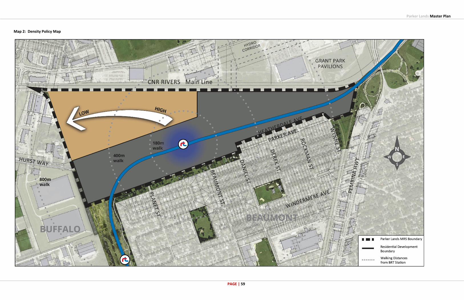
Parker Lands Master Plan
PAGE | 59
Map 2: Density Policy Map

Parker Lands Master Plan
PAGE | 60
Map 3: Transportation Policy Map

Parker Lands Master Plan
PAGE | 61
Map 4: Servicing Policy Map
Parker Lands Master Plan
PAGE | 62
9 APPENDICES
Appendix A: Engagement Report

Parker Lands Master Plan
PAGE | 63

Parker Lands Master Plan
PAGE | 64
Appendix B: Environmental Overview

Parker Lands Master Plan
PAGE | 65

Parker Lands Master Plan
PAGE | 66
Appendix C: Water, Wastewater and Stormwater Servicing Report

Parker Lands Master Plan
PAGE | 67

Parker Lands Master Plan
PAGE | 68
Appendix D: Traffic Analysis and Opportunity Memo

Parker Lands Master Plan
PAGE | 69

Parker Lands Master Plan
PAGE | 70
Appendix E: Urban Design Guidelines: Urban Neighbourhood Policy Area

Parker Lands Master Plan
PAGE | 71

Parker Lands Master Plan
PAGE | 72
Appendix F: Parker Lands: Ensuring Successful Prairie TOD Memo