Embed Size (px)
Citation preview
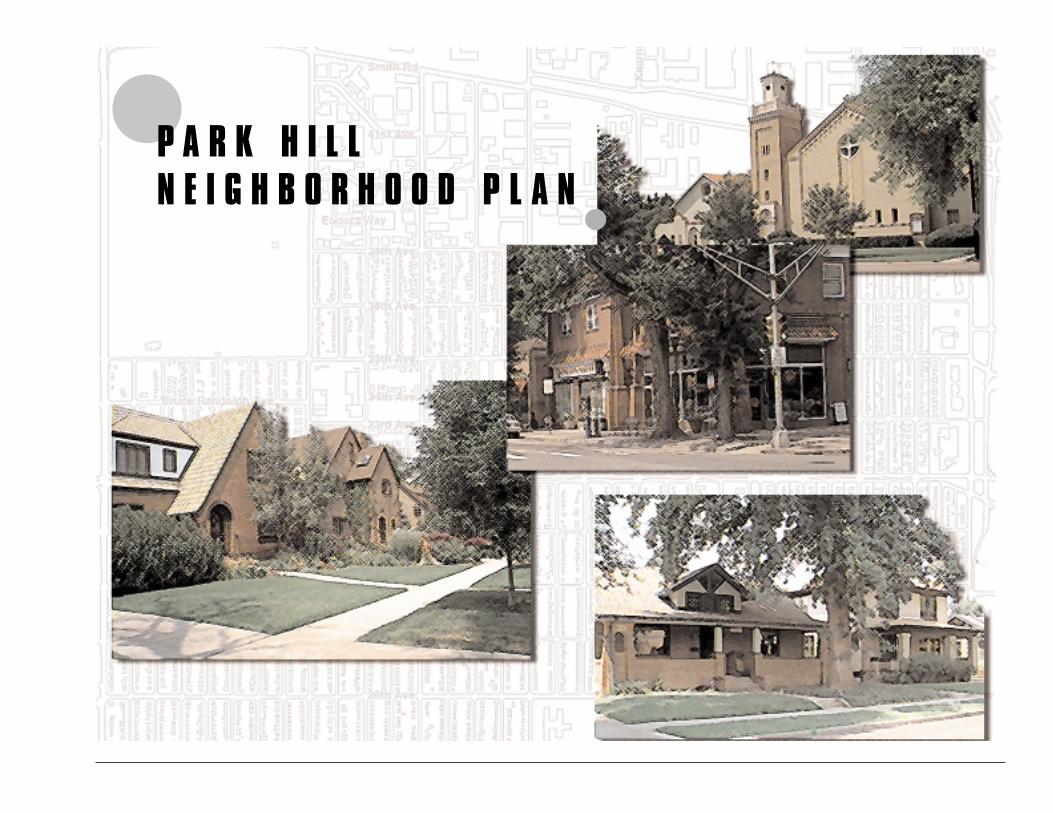
�P A R K H I L LN E I G H B O R H O O D P L A N
�
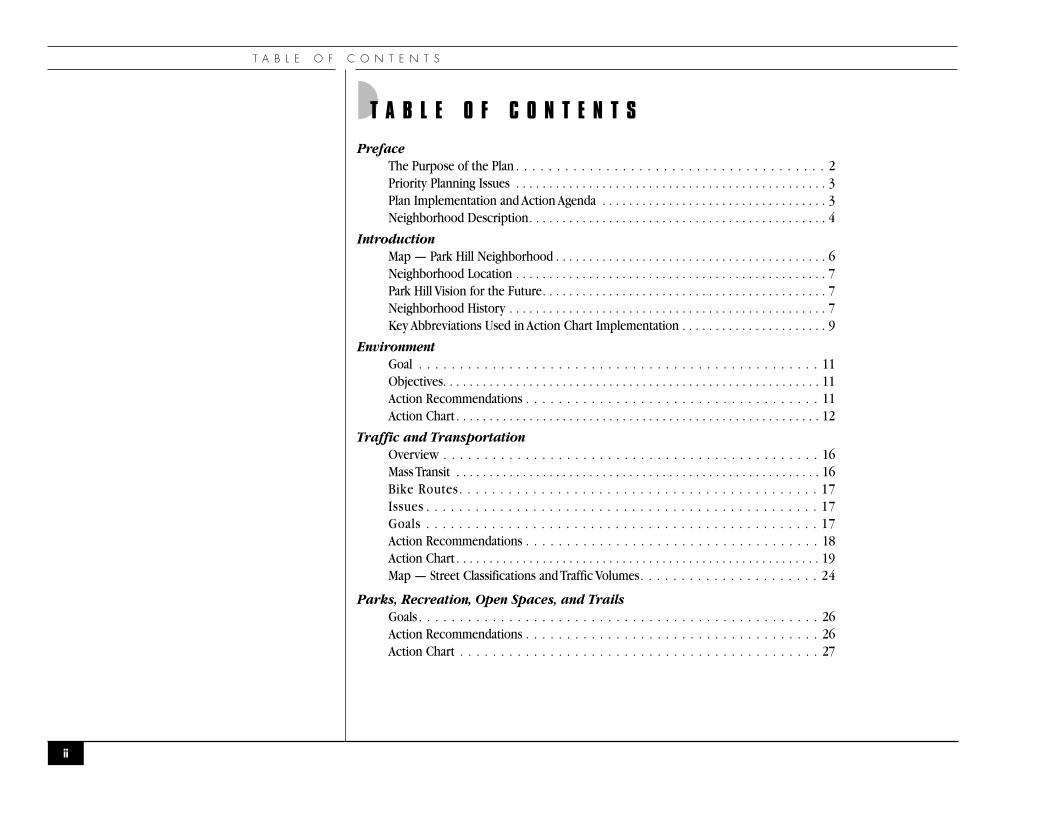
◗T A B L E O F C O N T E N T S
PrefaceThe Purpose of the Plan . . . . . . . . . . . . . . . . . . . . . . . . . . . . . . . . . . . . . . 2Priority Planning Issues . . . . . . . . . . . . . . . . . . . . . . . . . . . . . . . . . . . . . . . . . . . . . . . 3Plan Implementation and Action Agenda . . . . . . . . . . . . . . . . . . . . . . . . . . . . . . . . . . 3Neighborhood Description. . . . . . . . . . . . . . . . . . . . . . . . . . . . . . . . . . . . . . . . . . . . . 4
IntroductionMap — Park Hill Neighborhood . . . . . . . . . . . . . . . . . . . . . . . . . . . . . . . . . . . . . . . . . 6Neighborhood Location . . . . . . . . . . . . . . . . . . . . . . . . . . . . . . . . . . . . . . . . . . . . . . . 7Park Hill Vision for the Future. . . . . . . . . . . . . . . . . . . . . . . . . . . . . . . . . . . . . . . . . . . 7Neighborhood History . . . . . . . . . . . . . . . . . . . . . . . . . . . . . . . . . . . . . . . . . . . . . . . . 7Key Abbreviations Used in Action Chart Implementation . . . . . . . . . . . . . . . . . . . . . . 9
EnvironmentGoal . . . . . . . . . . . . . . . . . . . . . . . . . . . . . . . . . . . . . . . . . . . . . . . . . 11Objectives. . . . . . . . . . . . . . . . . . . . . . . . . . . . . . . . . . . . . . . . . . . . . . . . . . . . . . . . . 11Action Recommendations . . . . . . . . . . . . . . . . . . . . . . . . . . . . . . . . . . . . 11Action Chart . . . . . . . . . . . . . . . . . . . . . . . . . . . . . . . . . . . . . . . . . . . . . . . . . . . . . . . 12
Traffic and TransportationOverview . . . . . . . . . . . . . . . . . . . . . . . . . . . . . . . . . . . . . . . . . . . . . . 16Mass Transit . . . . . . . . . . . . . . . . . . . . . . . . . . . . . . . . . . . . . . . . . . . . . . . . . . . . . . . 16Bike Routes . . . . . . . . . . . . . . . . . . . . . . . . . . . . . . . . . . . . . . . . . . . . 17Issues . . . . . . . . . . . . . . . . . . . . . . . . . . . . . . . . . . . . . . . . . . . . . . . . 17Goals . . . . . . . . . . . . . . . . . . . . . . . . . . . . . . . . . . . . . . . . . . . . . . . . 17Action Recommendations . . . . . . . . . . . . . . . . . . . . . . . . . . . . . . . . . . . . 18Action Chart . . . . . . . . . . . . . . . . . . . . . . . . . . . . . . . . . . . . . . . . . . . . . . . . . . . . . . . 19Map — Street Classifications and Traffic Volumes. . . . . . . . . . . . . . . . . . . . . . 24
Parks, Recreation, Open Spaces, and TrailsGoals . . . . . . . . . . . . . . . . . . . . . . . . . . . . . . . . . . . . . . . . . . . . . . . . . 26Action Recommendations . . . . . . . . . . . . . . . . . . . . . . . . . . . . . . . . . . . . 26Action Chart . . . . . . . . . . . . . . . . . . . . . . . . . . . . . . . . . . . . . . . . . . . . 27
T A B L E O F C O N T E N T S
ii
P A R K H I L L N E I G H B O R H O O D P L A N
Land UseOverview . . . . . . . . . . . . . . . . . . . . . . . . . . . . . . . . . . . . . . . . . . . . . . . . . . . . . . . . . 30Residential Land Uses . . . . . . . . . . . . . . . . . . . . . . . . . . . . . . . . . . . . . . . . . . . . . . . . 30Special Residential Land Uses . . . . . . . . . . . . . . . . . . . . . . . . . . . . . . . . . . . . . . . . . . 30Commercial Land Uses . . . . . . . . . . . . . . . . . . . . . . . . . . . . . . . . . . . . . . . . . . . . . . . 31Vacantl Land . . . . . . . . . . . . . . . . . . . . . . . . . . . . . . . . . . . . . . . . . . . . . . . . . . . . . . 31Parks and Open Space . . . . . . . . . . . . . . . . . . . . . . . . . . . . . . . . . . . . . . . . . . . . . . . 31Schools . . . . . . . . . . . . . . . . . . . . . . . . . . . . . . . . . . . . . . . . . . . . . . . . . . . . . . . . . . . 31Goals . . . . . . . . . . . . . . . . . . . . . . . . . . . . . . . . . . . . . . . . . . . . . . . . . . . . . . . . . . . . 31Action Recomendations . . . . . . . . . . . . . . . . . . . . . . . . . . . . . . . . . . . . . . . . . . . . . . 32Action Chart . . . . . . . . . . . . . . . . . . . . . . . . . . . . . . . . . . . . . . . . . . . . . . . . . . . . . . . 33Map — Land Use . . . . . . . . . . . . . . . . . . . . . . . . . . . . . . . . . . . . . . . . . . . . . . . . . . . 37
Urban DesignOverview . . . . . . . . . . . . . . . . . . . . . . . . . . . . . . . . . . . . . . . . . . . . . . . . . . . . . . . . . 39Goals . . . . . . . . . . . . . . . . . . . . . . . . . . . . . . . . . . . . . . . . . . . . . . . . . . . . . . . . . . . . 39Action Recomendations . . . . . . . . . . . . . . . . . . . . . . . . . . . . . . . . . . . . . . . . . . . . . . 40Action Chart . . . . . . . . . . . . . . . . . . . . . . . . . . . . . . . . . . . . . . . . . . . . . . . . . . . . . . . 41
Public SafetyOverview . . . . . . . . . . . . . . . . . . . . . . . . . . . . . . . . . . . . . . . . . . . . . . . . . . . . . . . . . 45Goals . . . . . . . . . . . . . . . . . . . . . . . . . . . . . . . . . . . . . . . . . . . . . . . . . . . . . . . . . . . . 45Objectives. . . . . . . . . . . . . . . . . . . . . . . . . . . . . . . . . . . . . . . . . . . . . . . . . . . . . . . . . 45Action Recomendations . . . . . . . . . . . . . . . . . . . . . . . . . . . . . . . . . . . . . . . . . . . . . . 46Action Chart . . . . . . . . . . . . . . . . . . . . . . . . . . . . . . . . . . . . . . . . . . . . . . . . . . . . . . . 47
iii
T A B L E O F C O N T E N T S
Business and Economic DevelopmentOverview . . . . . . . . . . . . . . . . . . . . . . . . . . . . . . . . . . . . . . . . . . . . . . . . . . . . . . . . . 51
Colfax Ave. Business Corridor . . . . . . . . . . . . . . . . . . . . . . . . . . . . . . . . . . . . . . . 51Colorado Boulevard Business Corridor. . . . . . . . . . . . . . . . . . . . . . . . . . . . . . . . . 51Neighborhood Shopping Nodes. . . . . . . . . . . . . . . . . . . . . . . . . . . . . . . . . . . . . . 52Quebec St. Hotel Corridor . . . . . . . . . . . . . . . . . . . . . . . . . . . . . . . . . . . . . . . . . . 52Industrial Corridor . . . . . . . . . . . . . . . . . . . . . . . . . . . . . . . . . . . . . . . . . . . . . . . . 53
Issues and Goals . . . . . . . . . . . . . . . . . . . . . . . . . . . . . . . . . . . . . . . . . . . . . . . . . . . . 53Colfax Ave. Business Corridor . . . . . . . . . . . . . . . . . . . . . . . . . . . . . . . . . . . . . . . 53Colorado Boulevard Business Corridor. . . . . . . . . . . . . . . . . . . . . . . . . . . . . . . . . 54Neighborhood Shopping Nodes. . . . . . . . . . . . . . . . . . . . . . . . . . . . . . . . . . . . . . 54Quebec St. Hotel Corridor . . . . . . . . . . . . . . . . . . . . . . . . . . . . . . . . . . . . . . . . . . 54Industrial Corridor . . . . . . . . . . . . . . . . . . . . . . . . . . . . . . . . . . . . . . . . . . . . . . . . 54
Action Recomendations . . . . . . . . . . . . . . . . . . . . . . . . . . . . . . . . . . . . . . . . . . . . . . 54Action Chart . . . . . . . . . . . . . . . . . . . . . . . . . . . . . . . . . . . . . . . . . . . . . . . . . . . . . . . 55
Human Relations and Community ServicesGoals . . . . . . . . . . . . . . . . . . . . . . . . . . . . . . . . . . . . . . . . . . . . . . . . . . . . . . . . . . . . 59Plan Implementation and Action Agenda. . . . . . . . . . . . . . . . . . . . . . . . . . . . . . . . . . 59Action Recomendations . . . . . . . . . . . . . . . . . . . . . . . . . . . . . . . . . . . . . . . . . . . . . . 59Action Chart . . . . . . . . . . . . . . . . . . . . . . . . . . . . . . . . . . . . . . . . . . . . . . . . . . . . . . . 60
EducationOverview . . . . . . . . . . . . . . . . . . . . . . . . . . . . . . . . . . . . . . . . . . . . . . . . . . . . . . . . . 63Goals . . . . . . . . . . . . . . . . . . . . . . . . . . . . . . . . . . . . . . . . . . . . . . . . . . . . . . . . . . . . 63Priority Recomendations . . . . . . . . . . . . . . . . . . . . . . . . . . . . . . . . . . . . . . . . . . . . . 64Action Recomendations . . . . . . . . . . . . . . . . . . . . . . . . . . . . . . . . . . . . . . . . . . . . . . 64Action Chart . . . . . . . . . . . . . . . . . . . . . . . . . . . . . . . . . . . . . . . . . . . . . . . . . . . . . . . 65
Community CoordinationOverview . . . . . . . . . . . . . . . . . . . . . . . . . . . . . . . . . . . . . . . . . . . . . . . . . . . . . . . . . 68Goals . . . . . . . . . . . . . . . . . . . . . . . . . . . . . . . . . . . . . . . . . . . . . . . . . . . . . . . . . . . . 68Objectives. . . . . . . . . . . . . . . . . . . . . . . . . . . . . . . . . . . . . . . . . . . . . . . . . . . . . . . . . 68Action Recomendations . . . . . . . . . . . . . . . . . . . . . . . . . . . . . . . . . . . . . . . . . . . . . . 69Action Chart . . . . . . . . . . . . . . . . . . . . . . . . . . . . . . . . . . . . . . . . . . . . . . . . . . . . . . . 70
iv
P A R K H I L L N E I G H B O R H O O D P L A N
Dahlia and Holley Shopping Center RedevelopmentAction Recomendations . . . . . . . . . . . . . . . . . . . . . . . . . . . . . . . . . . . . . . . . . . . . . . 73Action Chart . . . . . . . . . . . . . . . . . . . . . . . . . . . . . . . . . . . . . . . . . . . . . . . . . . . . . . . 74Neighborhood Commercial Shopping Nodes . . . . . . . . . . . . . . . . . . . . . . . . . . . . . . 78Commercial Development . . . . . . . . . . . . . . . . . . . . . . . . . . . . . . . . . . . . . . . . . . . . 78Sidewalks . . . . . . . . . . . . . . . . . . . . . . . . . . . . . . . . . . . . . . . . . . . . . . . . . . . . . . . . . 79
Youth Meeting OutcomesOverview . . . . . . . . . . . . . . . . . . . . . . . . . . . . . . . . . . . . . . . . . . . . . . . . . . . . . . . . . 80Education . . . . . . . . . . . . . . . . . . . . . . . . . . . . . . . . . . . . . . . . . . . . . . . . . . . . . . . . . 82Public Safety . . . . . . . . . . . . . . . . . . . . . . . . . . . . . . . . . . . . . . . . . . . . . . . . . . . . . . . 84
Appendix A: Park Hill Urban Design GuidelinesResidential Areas. . . . . . . . . . . . . . . . . . . . . . . . . . . . . . . . . . . . . . . . . . . . . . . . . . . . 87Neighborhood Commercial Nodes . . . . . . . . . . . . . . . . . . . . . . . . . . . . . . . . . . . . . . 87Colfax Commercial Development. . . . . . . . . . . . . . . . . . . . . . . . . . . . . . . . . . . . . . . 88Industrial Areas . . . . . . . . . . . . . . . . . . . . . . . . . . . . . . . . . . . . . . . . . . . . . . . . . . . . . 89Sidewalks . . . . . . . . . . . . . . . . . . . . . . . . . . . . . . . . . . . . . . . . . . . . . . . . . . . . . . . . . 89
Appendix B: Zone District Descriptions and DefinitionsDescriptions and Definitions . . . . . . . . . . . . . . . . . . . . . . . . . . . . . . . . . . . . . . . . . . 90
Appendix C: AssessmentSummary . . . . . . . . . . . . . . . . . . . . . . . . . . . . . . . . . . . . . . . . . . . . . . . . . . . . . . . . 100Demographics . . . . . . . . . . . . . . . . . . . . . . . . . . . . . . . . . . . . . . . . . . . . . . . . . . . . 104Education and Schools . . . . . . . . . . . . . . . . . . . . . . . . . . . . . . . . . . . . . . . . . . . . . . 107Economic and Employment Characteristics . . . . . . . . . . . . . . . . . . . . . . . . . . . . . . 111Land Use and Zoning . . . . . . . . . . . . . . . . . . . . . . . . . . . . . . . . . . . . . . . . . . . . . . . 114Housing . . . . . . . . . . . . . . . . . . . . . . . . . . . . . . . . . . . . . . . . . . . . . . . . . . . . . . . . . 120Streets,Traffic and Public Transportation. . . . . . . . . . . . . . . . . . . . . . . . . . . . . . . . . 123Infrastructure . . . . . . . . . . . . . . . . . . . . . . . . . . . . . . . . . . . . . . . . . . . . . . . . . . . . . 127Public Safety . . . . . . . . . . . . . . . . . . . . . . . . . . . . . . . . . . . . . . . . . . . . . . . . . . . . . . 130Community Facilities . . . . . . . . . . . . . . . . . . . . . . . . . . . . . . . . . . . . . . . . . . . . . . . 132
Acknowledgements . . . . . . . . . . . . . . . . . . . . . . . . . . . . . . . . . . . . . . . . . . . . . . . . . . . . 137
v

P A R K H I L L N E I G H B O R H O O D P L A N
“...there has to be someone who is willing to do it, who is willing to take whatever risksare required. I don't think it can be done with money alone. The person has to bededicated to the task. There has to be some other motivation.”
— Cesar Chavez
1
�P R E F A C E�
P R E F A C E
◗THE PURPOSE OF THE PLAN
The Park Hill Plan has been years in the making. It represents the collective vision of communitymembers for the future of the Park Hill community, the goals for fulfilling that vision and the specificactions that should be taken to realize these goals. This plan is the result of countless hours of work bymore than 100 community members in collaboration with representatives of the City and County ofDenver’s Community Planning and Development Agency and other city departments. This plan will serveas a “road map” to guide the people of Park Hill as they walk together at the beginning of the 21st century.This plan also identifies the extensive and rich resources within Park Hill:“people” resources (our principalasset); the organizations dedicated to empowering community members; faith communities; human capitalservices, recreation programs and educational institutions
The plan serves as an official guide for the community and the rest of the city as to how Park Hillenvisions community-building, the neighborhood's physical and economic development, the delivery ofservices, and the overall improvement of the Park Hill community. The plan, approved by Denver’s CityCouncil, serves as a guide for making decisions about the neighborhood. It is the responsibility of theneighborhood organizations and assigned city staff to prioritize recommendations as time, energy andresources allow. Denver’s Comprehensive Plan 2000 is the foundation for the Park Hill Neighborhood Planand all official plans of the City. As adopted, the Park Hill Neighborhood Plan becomes an amendment tothe Denver Comprehensive Plan. Representatives of all City departments are to use this plan to guidepolicy recommendations and decisions.
This plan is intended to promote patterns of desired neighborhood change, urban design, housingdevelopment and preservation, business development, traffic flow and safety and other public services, allof which contribute to the economic, social, and physical health, safety and welfare of the people who liveand work in Park Hill.
This plan is not an official zone map nor does it imply or deny any implicit rights to a particular zone.Zone changes that may be proposed as part of this or any plan, must be initiated and adopted underseparate procedures established by the City and County of Denver Municipal Code.
2

P A R K H I L L N E I G H B O R H O O D P L A N
◗ Priority Planning Issues
The residents, business people, representatives of community-based organizations and city departmentswho helped shape the vision for Park Hill and this plan see tremendous potential as the Park HillNeighborhood builds on its assets and opportunities. As a result of numerous planning meetings, thePark Hill Neighborhood Plan identifies, places high priority and addresses the following issues that arecrucial to the future of the community.
◗ Environment
◗ Transportation
◗ Urban Design
◗ Public Safety
◗ Land use and Zoning
◗ Business and Economic Development
◗ Human Relations, Community Services and Coordination
◗ Education
◗ Parks, Recreation, Open Spaces and Trails
◗ Plan Implementation and Action Agenda
Each of the ten major policy areas of the plan (environment, transportation, parks and open space, landuse and zoning, urban design, public safety, business and economic development, human relations andcommunity services, education and community coordination) has an action agenda section that lists thespecific actions to be taken, the general time frames for carrying out the actions, and what organizationsand/or city departments should provide the resources to carry out the action items. The planning groupselected three action items from each policy area as “top priorities” for implementation.
3
P R E F A C E
◗ Neighborhood Description
Park Hill is a traditional city neighborhood with a small-town atmosphere. Here people of diversecultures, ages, races, and economic backgrounds share a sense of community. The community ischaracterized by large residential and industrial areas and smaller commercial areas. Major facilities in theneighborhood include: the Park Hill Golf Course, several neighborhood shopping areas at 35th Avenueand Dahlia Street, 33rd Avenue and Holly Street, 23rd Avenue and Dexter Street, 22nd Avenue and KearneyStreet, 23rd and Oneida and a large industrial area that extends north from 38th Avenue to the City line.There are also five public elementary schools, one elementary charter school, one middle school andnumerous faith institutions serving a wide range of faiths and denominations. The residential areas ParkHill of the community are south of 38th Avenue and east of Colorado Blvd. Immediately adjacent to ParkHill is City Park, which houses the Denver Museum of Nature and Science and the Denver Zoo. Both ofthese institutions impact the quality of life in Park Hill.
The neighborhood possesses many assets including a large stock of generally well maintained homes,excellent access to major transportation services and corridors, downtown Denver, and entertainmentfacilities, and three major parkways; 17th Avenue, Martin Luther King Blvd. Parkway and Monaco Parkway.There are two neighborhood organizations that serve Park Hill-- Greater Park Hill Community, Inc. (GPHC)and Park Hill for Safe Neighborhoods. GPHC publishes a monthly newspaper,The Greater Park Hill News.
4
P A R K H I L L N E I G H B O R H O O D P L A N
5
�I N T R O D U C T I O N�
I N T R O D U C T I O N
6
Interstate 70
38th Ave.
Smith Rd.
35th Ave.
34th Ave.
Martin Luther King Blvd.
23rd Ave.
Montview Blvd.
26th Ave.
17th Ave. Pkwy.
Colfax Ave.
48th Ave.
Colo
rado
Blv
d.
Dahl
ia S
t.
Elm
St.
Holly
St.
Mon
aco
St. P
kwy.
Queb
ec S
t.
28th Ave.
52nd Ave.
N
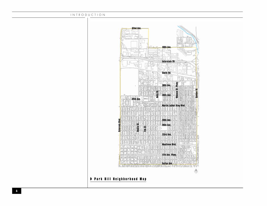
◗ P a r k H i l l N e i g h b o r h o o d M a p
P A R K H I L L N E I G H B O R H O O D P L A N
◗ Neighborhood Location
The Park Hill neighborhood is bounded on the west by Colorado Boulevard, on the north by the Citylimits, on the east by Quebec Street and on the south by Colfax Avenue.
◗ The Park Hill Vision for the Future
Park Hill vision for the future is to preserve and enhance the positive qualities that make theneighborhood a unique place to live, work, learn, and play.
◗ Preserve and continue to build on the image of a vibrant community that celebrates diversity ofpeople in ages, income, ethnic and cultural heritage.
◗ Create linkages to the future residential and business development in the new Stapletoncommunity to enhance the economic and social impacts on Park Hill.
◗ Create partnerships that involve residents, community based organizations, businesses, DenverCity Government, Denver Public Schools, Stapleton Development Corporation and Forest City(developers of Stapleton).
◗ Preserve and continue to build on the beautiful architecture, urban design, tree-lined streets andparkways with lively pedestrian-oriented commercial areas, positive, safe and usable parks, andopen space for meeting places and recreational activities.
◗ Create a universally safe neighborhood that builds on a strong sense of pride, communicationand cooperation among all neighbors.
◗ Continue to build a sustainable neighborhood that values quality of life, environment andtalented people.
◗ Attract high quality new businesses, retain and expand existing businesses that provide qualityservices, employment opportunities and character to the neighborhood.
◗ Neighborhood History
Park Hill’s colorful history began in 1886, when Baron Eugene Von Winkler bought and began to platwhat eventually was called “the finest square mile of real estate west of the Mississippi,”displacing theprairie dogs, rattlesnakes, and farms with fine homes. A steam railroad and trolley lines made this
7
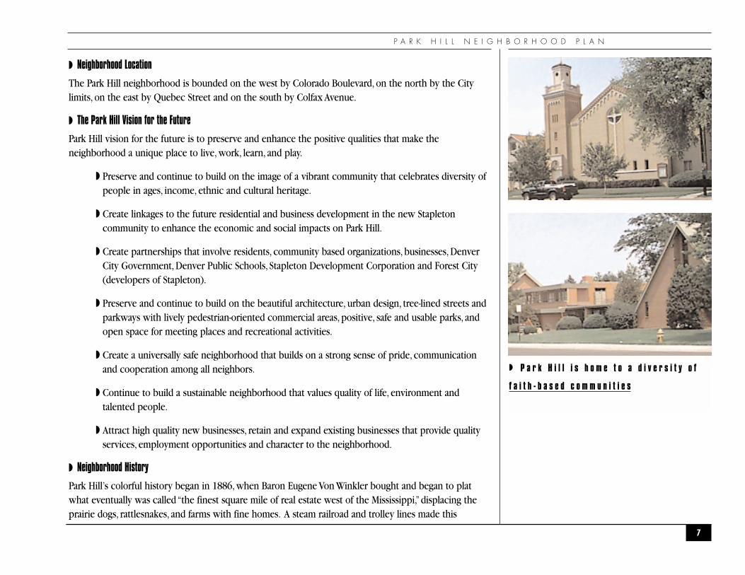
◗ P a r k H i l l i s h o m e t o a d i v e r s i t y o f
f a i t h - b a s e d c o m m u n i t i e s
I N T R O D U C T I O N
residential area accessible to downtown. And the nearness of City Park gave Park Hill residents thefeeling of both a suburb and a city.
The 1920s to the 1930s saw the next building boom in Park Hill -- while the propeller-driven planeslanding and taking off at Stapleton Airport hardly impacted the neighborhood. Residents were and areattracted to Park Hill because of the Museum of Nature and Science, the Denver Zoo, its proximity tohospitals and downtown, and the wide variety of housing styles from Tudors, Queen Anne’s, Bungalows,to Denver Squares.
After World War II, during the third growth and settlement wave, more modern homes were built formilitary veterans, and airline stewardesses and machinists who were employed at nearby StapletonAirport and businesses. Located in the northern area of Park Hill (north of 26th Avenue, many of thesenewer residences were single family ranch style homes built for first time homebuyers, and low-riseapartment buildings.
Greater Park Hill is an idea and a vision, as well as a place. The vision during the last 40 years has beento create a community where people of different racial, ethnic, economic and cultural backgroundswould live and work peaceably together to build a stronger neighborhood. Park Hill, which is oftencalled the “conscience”of the city, has created an “intentionally”multi-racial and multi-cultural community,whose inclusionary example has influenced the human relations climate of Denver and the whole stateof Colorado. Park Hill has become nationally known for its progressive efforts at promoting cultural andeconomic diversity. This is a legacy of which the neighborhood is proud.
8
P A R K H I L L N E I G H B O R H O O D P L A N
◗KEY TO ABBREVIATIONS USED IN ACTION CHART IMPLEMENTORS
BAs . . . . . . . . . . . . . . . . . . . . . . . . . . . . . .Business AssociationsCPDA . . . . . . . . . . . . . . . . . . . . . . . . . . . .Community Planning and Development Agency H&NDS . . . . . . . . . . . . . . . . . . . . . . . . . .Housing & Neighborhood Development ServicesNIS . . . . . . . . . . . . . . . . . . . . . . . . . . . . . .Neighborhood Inspection ServicesZA . . . . . . . . . . . . . . . . . . . . . . . . . . . . . .Zoning Administration CC . . . . . . . . . . . . . . . . . . . . . . . . . . . . . .Community CorrectionsCBOs . . . . . . . . . . . . . . . . . . . . . . . . . . . .Community-Based OrganizationsDPD . . . . . . . . . . . . . . . . . . . . . . . . . . . . .Denver Police DepartmentDA’s . . . . . . . . . . . . . . . . . . . . . . . . . . . . .District Attorney’s OfficeDURA . . . . . . . . . . . . . . . . . . . . . . . . . . . .Denver Urban and Renewal AuthorityDP&R . . . . . . . . . . . . . . . . . . . . . . . . . . . .Denver Parks and RecreationMOED . . . . . . . . . . . . . . . . . . . . . . . . . . .Mayor’s Office of Economic DevelopmentMOET . . . . . . . . . . . . . . . . . . . . . . . . . . . .Mayor’s Office of Employment and TrainingNOs . . . . . . . . . . . . . . . . . . . . . . . . . . . . .Neighborhood OrganizationsPW . . . . . . . . . . . . . . . . . . . . . . . . . . . . . .Public WorksPW-TE . . . . . . . . . . . . . . . . . . . . . . . . . . .Public Works-Transportation EngineeringPHBSO . . . . . . . . . . . . . . . . . . . . . . . . . . .Park Hill Business Support OfficeSDC . . . . . . . . . . . . . . . . . . . . . . . . . . . . .Stapleton Development CorporationSW . . . . . . . . . . . . . . . . . . . . . . . . . . . . . .Solid Waste
9
E N V I R O N M E N T
10
�E N V I R O N M E N T�
“Whatever is flexible and flowing will tend to grow,whatever is rigid and blocked will wither and die.”
— Tao Te Ching
P A R K H I L L N E I G H B O R H O O D P L A N
◗ Goal
Through neighborhood advocacy and stewardship, the residents and property owners of Park Hillwish to maintain and protect the built and natural features of the community including trees, parksand open space, and parkways. To encourage residents and businesses to preserve and enhance thephysical environment of their neighborhood through education, self-help activities and standards setin local ordinances.
◗ Objectives
1 Develop a partnership with and mechanisms for regular contact with the City Forester’s officeto insure that the maintenance and replacement programs for trees in parks and parkwayscontinue to be adequate.
2 Develop mechanisms to safeguard, clean up, and restore the air, water and soils of Park Hill.
3 Improve the environmental quality of the industrial corridor.
The action recommendations have been divided into on-going, short term and long term. On-goingrecommendations can be started immediately and continue. Short-term recommendations can be startedimmediately with limited resources or no money. Long-term recommendations will take longer toaccomplish and will require funding.
The action items relating to the environment that the planning group selected as its “top priorities”areas follows (in cases where more than three items appear, there was a tie for one of the positions):
◗ Action Recommendations
1. E-18 Perform an inventory of brownfields and contaminated businesses in Park Hill. Exploreopportunities to mitigate these sites through clean up, rehabilitation and/or redevelopment.
2. E6 Conduct a major clean up of all quadrants in the neighborhood twice a year through the “KeepDenver Beautiful”campaign.
2. E21 Track complaints about Section 8 landlords and facilities and mitigate these issues.
3. E8 Identify the top 25 blighted properties two times a year in an effort to bring them into compliance with relevant codes.
11
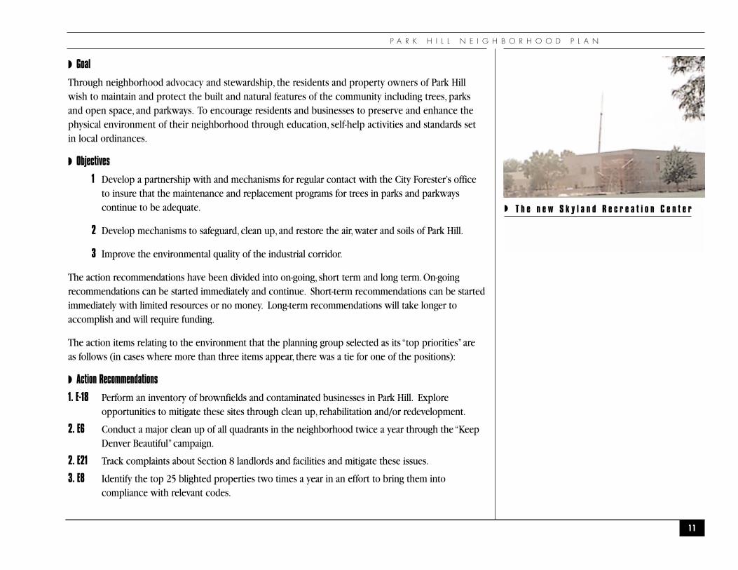
◗ T h e n e w S k y l a n d R e c r e a t i o n C e n t e r
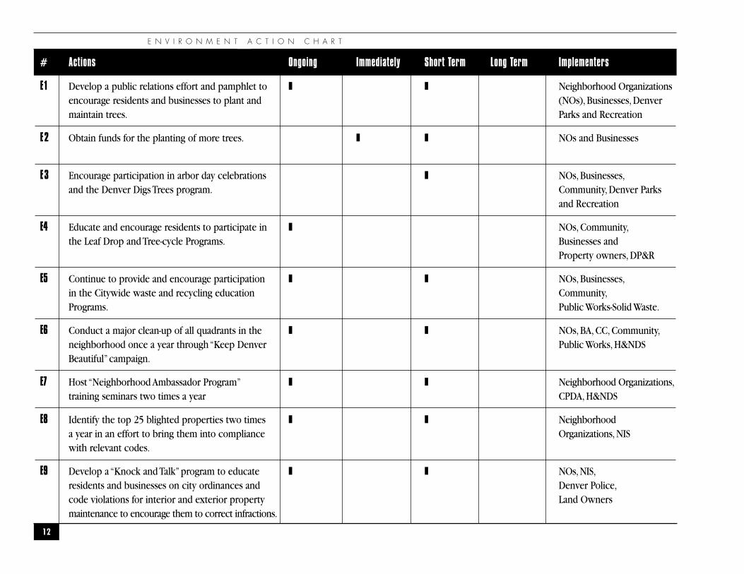
E N V I R O N M E N T A C T I O N C H A R T
12
# Actions Ongoing Immediately Short Term Long Term Implementers
E1 Develop a public relations effort and pamphlet to ❚ ❚ Neighborhood Organizations encourage residents and businesses to plant and (NOs), Businesses, Denver maintain trees. Parks and Recreation
E2 Obtain funds for the planting of more trees. ❚ ❚ NOs and Businesses
E3 Encourage participation in arbor day celebrations ❚ NOs, Businesses,and the Denver Digs Trees program. Community, Denver Parks
and Recreation
E4 Educate and encourage residents to participate in ❚ NOs, Community,the Leaf Drop and Tree-cycle Programs. Businesses and
Property owners, DP&R
E5 Continue to provide and encourage participation ❚ ❚ NOs, Businesses,in the Citywide waste and recycling education Community,Programs. Public Works-Solid Waste.
E6 Conduct a major clean-up of all quadrants in the ❚ ❚ NOs, BA, CC, Community,neighborhood once a year through “Keep Denver Public Works, H&NDSBeautiful”campaign.
E7 Host “Neighborhood Ambassador Program” ❚ ❚ Neighborhood Organizations,training seminars two times a year CPDA, H&NDS
E8 Identify the top 25 blighted properties two times ❚ ❚ Neighborhood a year in an effort to bring them into compliance Organizations, NISwith relevant codes.
E9 Develop a “Knock and Talk”program to educate ❚ ❚ NOs,NIS,residents and businesses on city ordinances and Denver Police,code violations for interior and exterior property Land Ownersmaintenance to encourage them to correct infractions.
P A R K H I L L N E I G H B O R H O O D P L A N
13
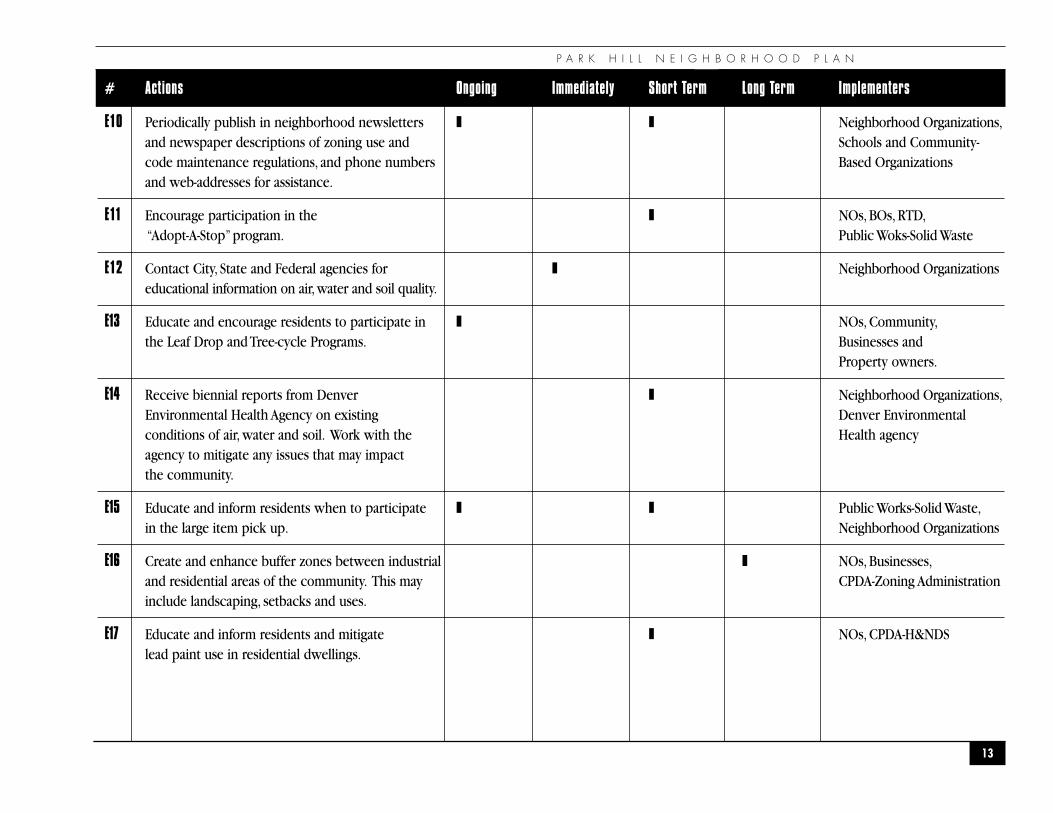
# Actions Ongoing Immediately Short Term Long Term Implementers
E10 Periodically publish in neighborhood newsletters ❚ ❚ Neighborhood Organizations,and newspaper descriptions of zoning use and Schools and Community- code maintenance regulations, and phone numbers Based Organizationsand web-addresses for assistance.
E11 Encourage participation in the ❚ NOs, BOs, RTD,“Adopt-A-Stop”program. Public Woks-Solid Waste
E12 Contact City, State and Federal agencies for ❚ Neighborhood Organizationseducational information on air,water and soil quality.
E13 Educate and encourage residents to participate in ❚ NOs, Community,the Leaf Drop and Tree-cycle Programs. Businesses and
Property owners.
E14 Receive biennial reports from Denver ❚ Neighborhood Organizations,Environmental Health Agency on existing Denver Environmentalconditions of air, water and soil. Work with the Health agencyagency to mitigate any issues that may impact the community.
E15 Educate and inform residents when to participate ❚ ❚ Public Works-Solid Waste,in the large item pick up. Neighborhood Organizations
E16 Create and enhance buffer zones between industrial ❚ NOs, Businesses,and residential areas of the community. This may CPDA-Zoning Administrationinclude landscaping, setbacks and uses.
E17 Educate and inform residents and mitigate ❚ NOs, CPDA-H&NDSlead paint use in residential dwellings.
E N V I R O N M E N T A C T I O N C H A R T
14
# Actions Ongoing Immediately Short Term Long Term Implementers
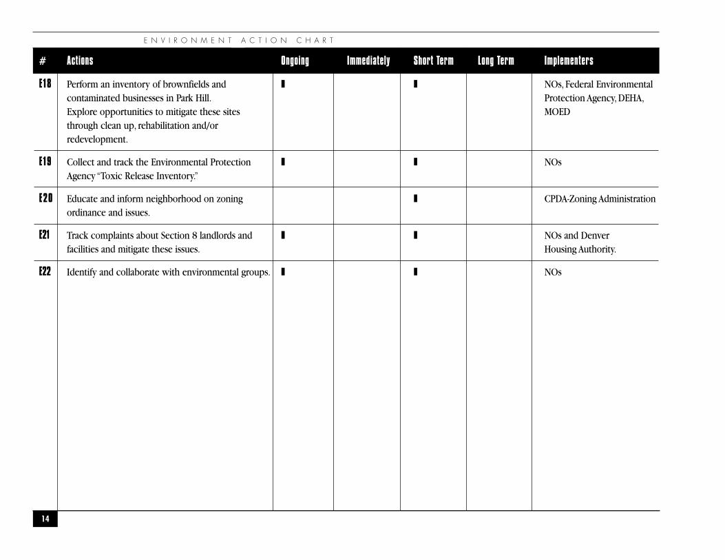
E18 Perform an inventory of brownfields and ❚ ❚ NOs, Federal Environmentalcontaminated businesses in Park Hill. Protection Agency, DEHA,Explore opportunities to mitigate these sites MOEDthrough clean up, rehabilitation and/or redevelopment.
E19 Collect and track the Environmental Protection ❚ ❚ NOsAgency “Toxic Release Inventory.”
E20 Educate and inform neighborhood on zoning ❚ CPDA-Zoning Administrationordinance and issues.
E21 Track complaints about Section 8 landlords and ❚ ❚ NOs and Denverfacilities and mitigate these issues. Housing Authority.
E22 Identify and collaborate with environmental groups. ❚ ❚ NOs
P A R K H I L L N E I G H B O R H O O D P L A N
15
�T R A F F I C A N D T R A N S P O R T A T I O N
�
“There is more to life than increasing speed.”
— Mohandas K. Gandhi

T R A F F I C A N D T R A N S P O R T A T I O N
◗OVERVIEW
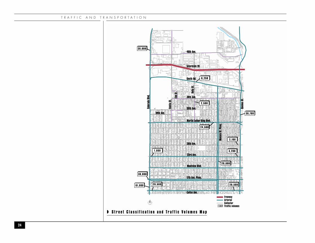
Park Hill residents have several modes of transportation at their disposal. The primary mode oftransportation is the automobile followed by bus service, pedestrian and bicycle paths and futurecommuter rail. There are three designations used by the City in classifying streets: arterial, collectors, andlocal streets.
◗ Arterial streets have the function of permitting rapid and relatively unimpeded trafficmovement through the city and serving as a primary link between communities and majorland use elements. A number of major arterials are designed as state highways. Arterialstypically carry a range of volumes from 10,000 vehicles per day to 50,000 vehicles per day.Arterial streets in Park Hill include; Colorado Boulevard, Smith Road, Colfax Avenue, QuebecStreet, Martin Luther King Boulevard Parkway, Monaco Street Parkway, 23rd Avenue, MontviewBoulevard and 17th Avenue Parkway.
◗ Collector streets have the function of collecting and distributing traffic having an origin ordestination between arterial and local streets within the community, and linking neighborhoodresidential areas, shopping and service facilities, and employment areas. Collectors typically carrya range from 3,000 vehicles per day to 12,000 vehicles per day. Collector streets in Park Hillinclude; 48th Avenue, 38th Avenue, 35th Avenue, 34th Avenue, Dahlia Street (MLK to City limits),Holly Street (MLK to 48th Avenue) and 26th Avenue.
◗ Local streets have the function of providing direct access to adjacent properties.They carry lowvolumes of traffic typically from 300 vehicles per day up to 1,500 vehicles per day with an originor destination within the neighborhood.
◗ Mass Transit
Park Hill is served by several Regional Transportation District Routes. Routes 15, 20, 28, 38, 40, 43, 44, 65and 105. These routes provide for adequate neighborhood geographic coverage based on walkingdistance to bus stops. However, there are too few East and West routes (15, 20, 28, 38, and 44) for such alarge residential oriented neighborhood.
16
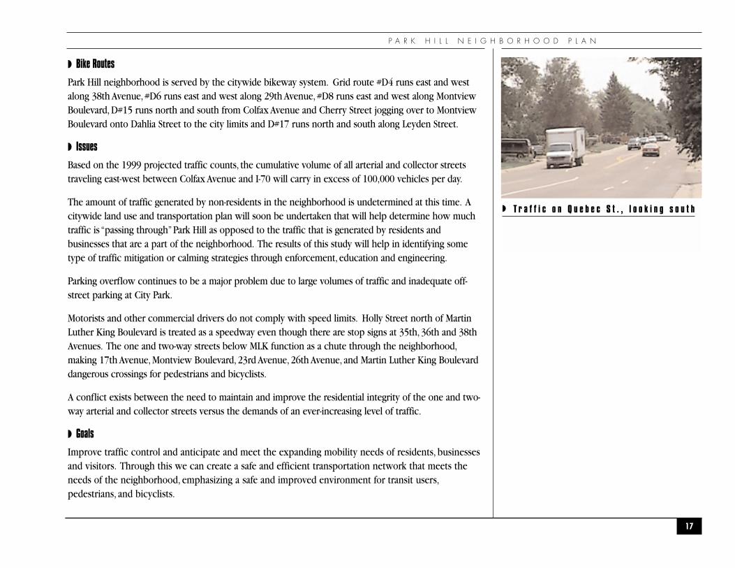
◗ T h r o u g h t r a f f i c o n s h o u l d b e e n c o u r a g e d
t o s t a y o n Q u e b e c S t . , a n a r t e r i a l s t r e e t .
P A R K H I L L N E I G H B O R H O O D P L A N
◗ Bike Routes
Park Hill neighborhood is served by the citywide bikeway system. Grid route #D4 runs east and westalong 38th Avenue, #D6 runs east and west along 29th Avenue, #D8 runs east and west along MontviewBoulevard, D#15 runs north and south from Colfax Avenue and Cherry Street jogging over to MontviewBoulevard onto Dahlia Street to the city limits and D#17 runs north and south along Leyden Street.
◗ Issues
Based on the 1999 projected traffic counts, the cumulative volume of all arterial and collector streetstraveling east-west between Colfax Avenue and I-70 will carry in excess of 100,000 vehicles per day.
The amount of traffic generated by non-residents in the neighborhood is undetermined at this time. Acitywide land use and transportation plan will soon be undertaken that will help determine how muchtraffic is “passing through”Park Hill as opposed to the traffic that is generated by residents andbusinesses that are a part of the neighborhood. The results of this study will help in identifying sometype of traffic mitigation or calming strategies through enforcement, education and engineering.
Parking overflow continues to be a major problem due to large volumes of traffic and inadequate off-street parking at City Park.
Motorists and other commercial drivers do not comply with speed limits. Holly Street north of MartinLuther King Boulevard is treated as a speedway even though there are stop signs at 35th, 36th and 38thAvenues. The one and two-way streets below MLK function as a chute through the neighborhood,making 17th Avenue, Montview Boulevard, 23rd Avenue, 26th Avenue, and Martin Luther King Boulevarddangerous crossings for pedestrians and bicyclists.
A conflict exists between the need to maintain and improve the residential integrity of the one and two-way arterial and collector streets versus the demands of an ever-increasing level of traffic.
◗ Goals
Improve traffic control and anticipate and meet the expanding mobility needs of residents, businessesand visitors. Through this we can create a safe and efficient transportation network that meets theneeds of the neighborhood, emphasizing a safe and improved environment for transit users,pedestrians, and bicyclists.
17
◗ T r a f f i c o n Q u e b e c S t . , l o o k i n g s o u t h
T R A F F I C A N D T R A N S P O R T A T I O N
Protect and maintain the quality of life enjoyed by residents of Park Hill, especially those on arterial andcollector streets, by enforcing speed limits, improving road conditions, addressing aesthetic issues and theappropriate timing of maintenance and repair operations.
◗ Action Recommendations
The action recommendations have been divided into on-going, short term and long term. On-goingrecommendations can be started immediately and continue. Short-term recommendations can be startedimmediately with limited resources or no money. Long-term recommendations will take longer toaccomplish and will require funding.
The neighborhood selected three projects from each policy area as “top priorities” for implementation.
1. T-4 Enhance the use of alternative modes (walking, bicycling and transit) through the following:Improvement of landscaping along arterial and collector street right of ways, Installation of citystandard bicycle racks in neighborhood commercial areas, Construction of city standardsidewalks along arterial and collector street with pedestrian ramps and intersections, andEnhance shelters, benches, for hard surface waiting areas at bus stops so they become assets tothe neighborhood.
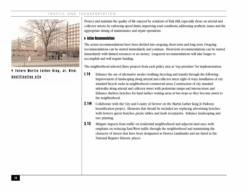
2. T-14 Collaborate with the City and County of Denver on the Martin Luther King Jr. Parkwaybeautification project. Elements that should be included are replacing advertising bencheswith bowery green benches, picnic tables, and trash receptacles. Enhance landscaping andtree planting.
3. T-3 Mitigate impacts from traffic on residential neighborhood and adjacent land uses, withemphasis on reducing East/West traffic through the neighborhood and maintaining thecharacter of streets that have been designated as Denver Landmarks and are listed in theNational Register Historic places.
18
◗ F u t u r e M a r t i n L u t h e r K i n g , J r. B l v d .
b e u t i f i c a t i o n s i t e
P A R K H I L L N E I G H B O R H O O D P L A N
19
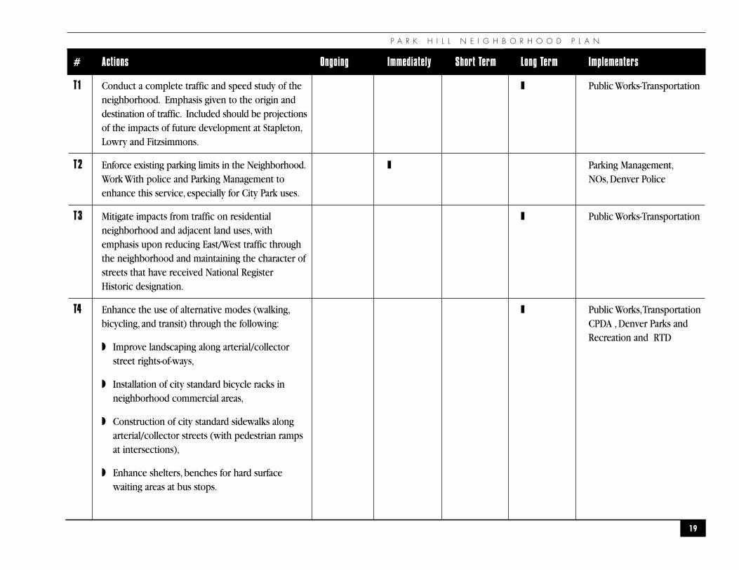
# Actions Ongoing Immediately Short Term Long Term Implementers
T1 Conduct a complete traffic and speed study of the ❚ Public Works-Transportationneighborhood. Emphasis given to the origin and destination of traffic. Included should be projectionsof the impacts of future development at Stapleton,Lowry and Fitzsimmons.
T2 Enforce existing parking limits in the Neighborhood. ❚ Parking Management,Work With police and Parking Management to NOs, Denver Policeenhance this service, especially for City Park uses.
T3 Mitigate impacts from traffic on residential ❚ Public Works-Transportationneighborhood and adjacent land uses, with emphasis upon reducing East/West traffic through the neighborhood and maintaining the character of streets that have received National Register Historic designation.
T4 Enhance the use of alternative modes (walking, ❚ Public Works,Transportationbicycling, and transit) through the following: CPDA , Denver Parks and
◗ Improve landscaping along arterial/collectorstreet rights-of-ways,
◗ Installation of city standard bicycle racks in neighborhood commercial areas,
◗ Construction of city standard sidewalks along arterial/collector streets (with pedestrian rampsat intersections),
◗ Enhance shelters, benches for hard surface waiting areas at bus stops.
Recreation and RTD
T R A F F I C A N D T R A N S P O R T A T I O N A C T I O N C H A R T
20
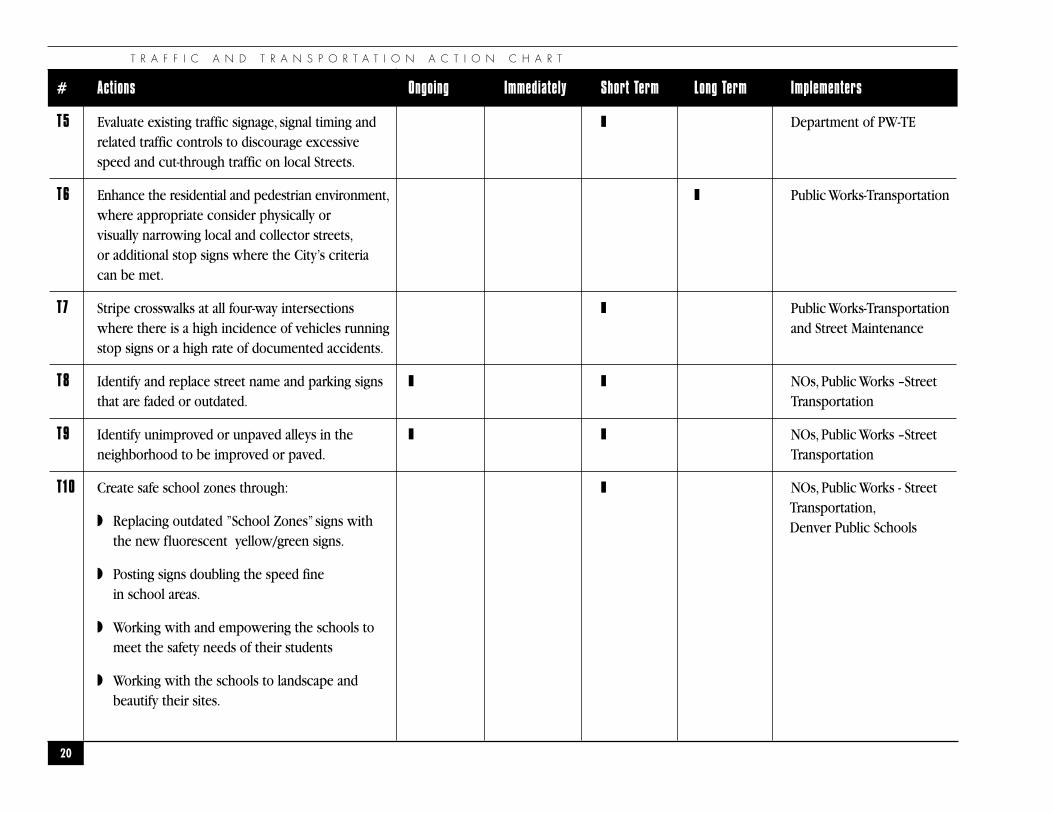
# Actions Ongoing Immediately Short Term Long Term Implementers
T5 Evaluate existing traffic signage, signal timing and ❚ Department of PW-TErelated traffic controls to discourage excessive speed and cut-through traffic on local Streets.
T6 Enhance the residential and pedestrian environment, ❚ Public Works-Transportationwhere appropriate consider physically orvisually narrowing local and collector streets,or additional stop signs where the City’s criteriacan be met.
T7 Stripe crosswalks at all four-way intersections ❚ Public Works-Transportationwhere there is a high incidence of vehicles running and Street Maintenancestop signs or a high rate of documented accidents.
T8 Identify and replace street name and parking signs ❚ ❚ NOs, Public Works –Street that are faded or outdated. Transportation
T9 Identify unimproved or unpaved alleys in the ❚ ❚ NOs, Public Works –Street neighborhood to be improved or paved. Transportation
T10 Create safe school zones through: ❚
◗ Replacing outdated ”School Zones” signs with the new fluorescent yellow/green signs.
◗ Posting signs doubling the speed fine in school areas.
◗ Working with and empowering the schools to meet the safety needs of their students
◗ Working with the schools to landscape andbeautify their sites.
NOs, Public Works - StreetTransportation,Denver Public Schools
P A R K H I L L N E I G H B O R H O O D P L A N
21
# Actions Ongoing Immediately Short Term Long Term Implementers
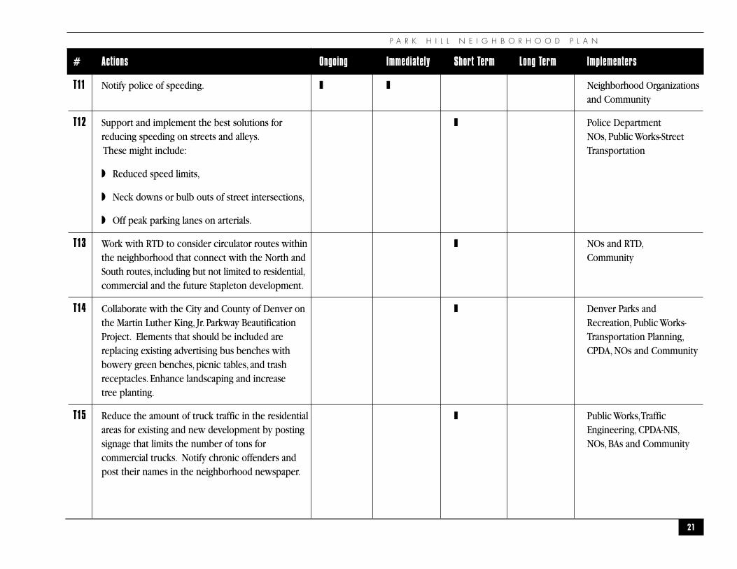
T11 Notify police of speeding. ❚ ❚ Neighborhood Organizationsand Community
T12 Support and implement the best solutions for ❚ Police Departmentreducing speeding on streets and alleys. NOs, Public Works-StreetThese might include: Transportation
◗ Reduced speed limits,
◗ Neck downs or bulb outs of street intersections,
◗ Off peak parking lanes on arterials.
T13 Work with RTD to consider circulator routes within ❚ NOs and RTD,the neighborhood that connect with the North and CommunitySouth routes, including but not limited to residential,commercial and the future Stapleton development.
T14 Collaborate with the City and County of Denver on ❚ Denver Parks and the Martin Luther King, Jr. Parkway Beautification Recreation, Public Works-Project. Elements that should be included are Transportation Planning,replacing existing advertising bus benches with CPDA, NOs and Communitybowery green benches, picnic tables, and trash receptacles. Enhance landscaping and increase tree planting.
T15 Reduce the amount of truck traffic in the residential ❚ Public Works,Traffic areas for existing and new development by posting Engineering, CPDA-NIS,signage that limits the number of tons for NOs, BAs and Communitycommercial trucks. Notify chronic offenders and post their names in the neighborhood newspaper.
T R A F F I C A N D T R A N S P O R T A T I O N A C T I O N C H A R T
22
# Actions Ongoing Immediately Short Term Long Term Implementers
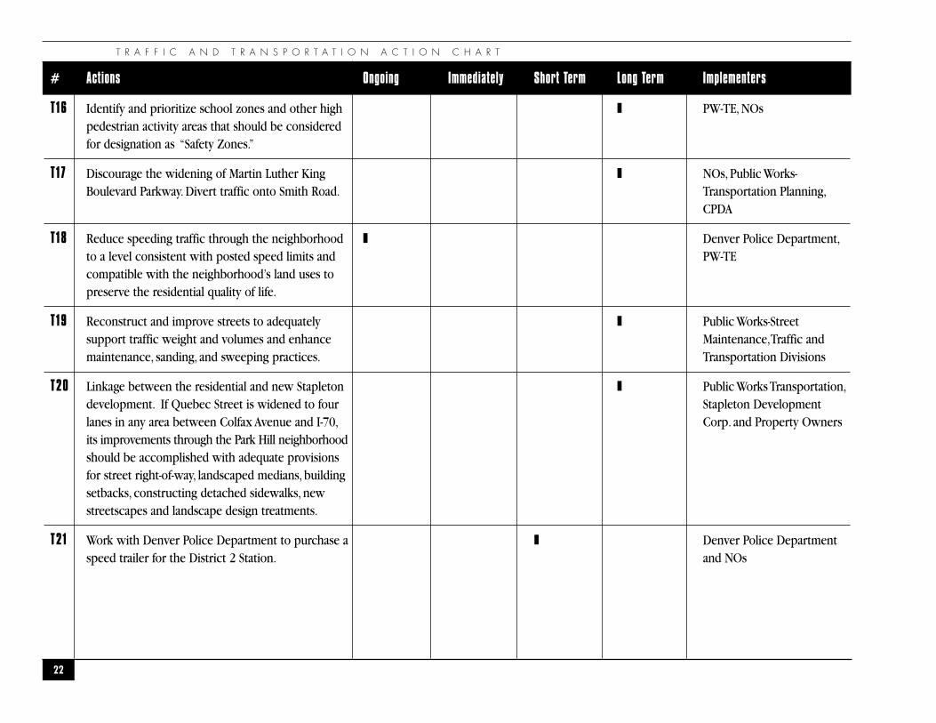
T16 Identify and prioritize school zones and other high ❚ PW-TE, NOspedestrian activity areas that should be considered for designation as “Safety Zones.”
T17 Discourage the widening of Martin Luther King ❚ NOs, Public Works-Boulevard Parkway. Divert traffic onto Smith Road. Transportation Planning,
CPDA
T18 Reduce speeding traffic through the neighborhood ❚ Denver Police Department,to a level consistent with posted speed limits and PW-TEcompatible with the neighborhood’s land uses to preserve the residential quality of life.
T19 Reconstruct and improve streets to adequately ❚ Public Works-Street support traffic weight and volumes and enhance Maintenance,Traffic and maintenance, sanding, and sweeping practices. Transportation Divisions
T20 Linkage between the residential and new Stapleton ❚ Public Works Transportation,development. If Quebec Street is widened to four Stapleton Development lanes in any area between Colfax Avenue and I-70, Corp. and Property Ownersits improvements through the Park Hill neighborhood should be accomplished with adequate provisionsfor street right-of-way, landscaped medians, building setbacks, constructing detached sidewalks, new streetscapes and landscape design treatments.
T21 Work with Denver Police Department to purchase a ❚ Denver Police Department speed trailer for the District 2 Station. and NOs
P A R K H I L L N E I G H B O R H O O D P L A N
23
# Actions Ongoing Immediately Short Term Long Term Implementers
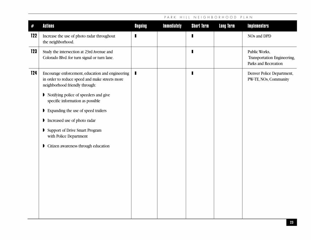
T22 Increase the use of photo radar throughout ❚ ❚ NOs and DPDthe neighborhood.
T23 Study the intersection at 23rd Avenue and ❚ Public Works,Colorado Blvd. for turn signal or turn lane. Transportation Engineering,
Parks and Recreation
T24 Encourage enforcement, education and engineering ❚ ❚ Denver Police Department,in order to reduce speed and make streets more PW-TE, NOs, Communityneighborhood friendly through:
◗ Notifying police of speeders and give specific information as possible
◗ Expanding the use of speed trailers
◗ Increased use of photo radar
◗ Support of Drive Smart Program with Police Department
◗ Citizen awareness through education
T R A F F I C A N D T R A N S P O R T A T I O N
24
Martin Luther King Blvd.
23rd Ave.
Montview Blvd.
26th Ave.
38th Ave.
48th Ave.
Smith Rd.
Interstate 70
35th Ave.
34th Ave.
Dahl
ia S
t.
Elm S
t.
Color
ado
Blvd
.
Queb
ec S
t.
Mona
co S
t. Pk
wy.
Holly
St.
17th Ave. Pkwy.
Colfax Ave.
3 6 , 7 0 0
3 8 , 6 0 0
2 0 , 6 0 0
6 1 , 0 0 0
2 , 5 0 0
6 , 2 5 0
2 4 , 5 0 0
2 , 1 0 0
7 , 8 0 0 3 , 2 0 0
3 6 , 0 0 0
2 8 , 5 0 02 9 , 5 0 0
N
FreewayArterialCollector
7 , 8 0 0 Traffic volumes
◗ S t r e e t C l a s s i f i c a t i o n a n d T r a f f i c V o l u m e s M a p
P A R K H I L L N E I G H B O R H O O D P L A N
25
�P A R K S , O P E N S P A C E , A N D T R A I L S
�
“If you live on this land, and you have ancestors sleeping in this land, I believe thatmakes you a native to this land. It has nothing to do with the color of your skin. I wasnot raised to look at people racially. What I was taught is that we’re flowers in theGreat Spirit’s garden. We share a common root, and the root is Mother Earth.”
— Oh Shinnah
P A R K S , O P E N S P A C E , A N D T R A I L S
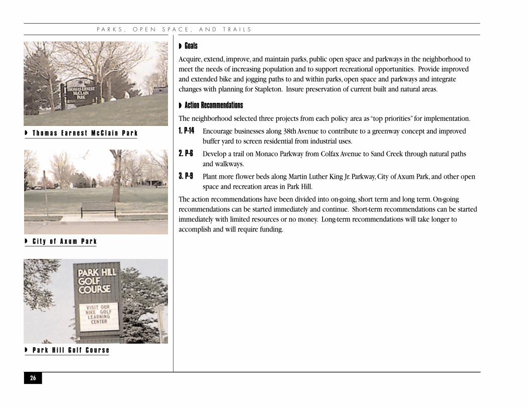
◗ Goals
Acquire, extend, improve, and maintain parks, public open space and parkways in the neighborhood tomeet the needs of increasing population and to support recreational opportunities. Provide improvedand extended bike and jogging paths to and within parks, open space and parkways and integratechanges with planning for Stapleton. Insure preservation of current built and natural areas.
◗ Action Recommendations
The neighborhood selected three projects from each policy area as “top priorities” for implementation.
1. P-14 Encourage businesses along 38th Avenue to contribute to a greenway concept and improvedbuffer yard to screen residential from industrial uses.
2. P-6 Develop a trail on Monaco Parkway from Colfax Avenue to Sand Creek through natural paths and walkways.
3. P-9 Plant more flower beds along Martin Luther King Jr. Parkway, City of Axum Park, and other openspace and recreation areas in Park Hill.
The action recommendations have been divided into on-going, short term and long term. On-goingrecommendations can be started immediately and continue. Short-term recommendations can be startedimmediately with limited resources or no money. Long-term recommendations will take longer toaccomplish and will require funding.
26
◗ T h o m a s E a r n e s t M c C l a i n P a r k
◗ C i t y o f A x u m P a r k
◗ P a r k H i l l G o l f C o u r s e
P A R K H I L L N E I G H B O R H O O D P L A N
27
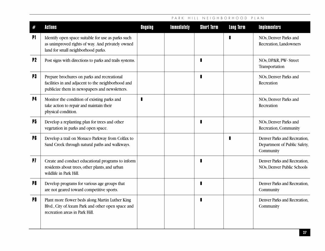
# Actions Ongoing Immediately Short Term Long Term Implementers
P1 Identify open space suitable for use as parks such ❚ NOs, Denver Parks and as unimproved rights of way. And privately owned Recreation, Landownersland for small neighborhood parks.
P2 Post signs with directions to parks and trails systems. ❚ NOs, DP&R, PW- Street Transportation
P3 Prepare brochures on parks and recreational ❚ NOs, Denver Parks and facilities in and adjacent to the neighborhood and Recreationpublicize them in newspapers and newsletters.
P4 Monitor the condition of existing parks and ❚ NOs, Denver Parks and take action to repair and maintain their Recreationphysical condition.
P5 Develop a replanting plan for trees and other ❚ NOs, Denver Parks and vegetation in parks and open space. Recreation, Community
P6 Develop a trail on Monaco Parkway from Colfax to ❚ Denver Parks and Recreation,Sand Creek through natural paths and walkways. Department of Public Safety,
Community
P7 Create and conduct educational programs to inform ❚ Denver Parks and Recreation,residents about trees, other plants, and urban NOs, Denver Public Schools wildlife in Park Hill.
P8 Develop programs for various age groups that ❚ Denver Parks and Recreation,are not geared toward competitive sports. Community
P9 Plant more flower beds along Martin Luther King ❚ Denver Parks and Recreation,Blvd., City of Axum Park and other open space and Communityrecreation areas in Park Hill.
P A R K S , O P E N S P A C E A N D T R A I L S A C T I O N C H A R T
28
# Actions Ongoing Immediately Short Term Long Term Implementers
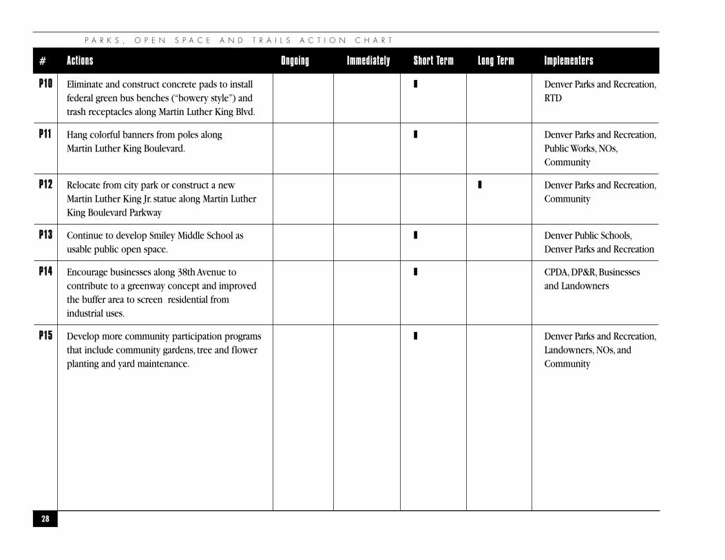
P10 Eliminate and construct concrete pads to install ❚ Denver Parks and Recreation,federal green bus benches (“bowery style”) and RTD trash receptacles along Martin Luther King Blvd.
P11 Hang colorful banners from poles along ❚ Denver Parks and Recreation,Martin Luther King Boulevard. Public Works, NOs,
Community
P12 Relocate from city park or construct a new ❚ Denver Parks and Recreation,Martin Luther King Jr. statue along Martin Luther CommunityKing Boulevard Parkway
P13 Continue to develop Smiley Middle School as ❚ Denver Public Schools,usable public open space. Denver Parks and Recreation
P14 Encourage businesses along 38th Avenue to ❚ CPDA, DP&R, Businessescontribute to a greenway concept and improved and Landownersthe buffer area to screen residential from industrial uses.
P15 Develop more community participation programs ❚ Denver Parks and Recreation,that include community gardens, tree and flower Landowners, NOs, andplanting and yard maintenance. Community
P A R K H I L L N E I G H B O R H O O D P L A N
29
�L A N D U S E A N D Z O N I N G�
“Never doubt that a small group of committed citizens can change the world.Indeed, it’s the only thing that has.”
— Margaret Meade
L A N D U S E A N D Z O N I N G
◗OVERVIEW
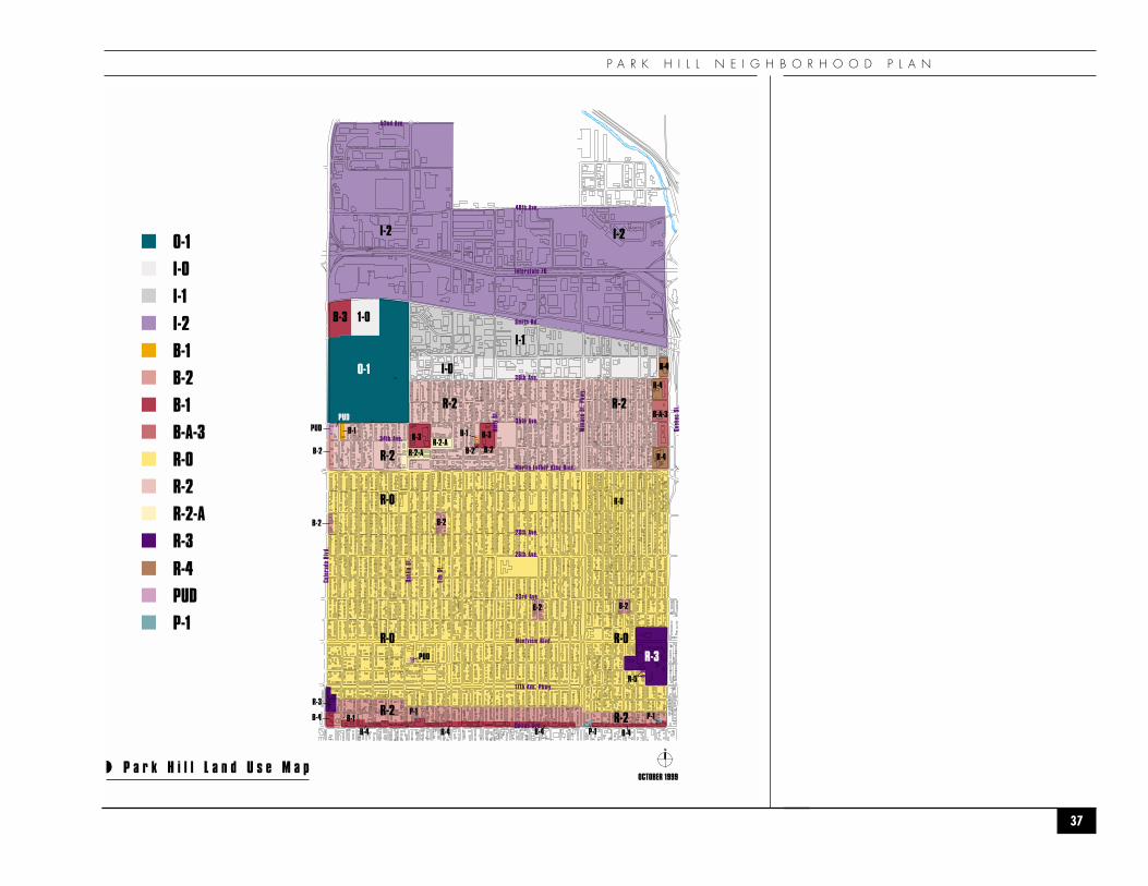
Park Hill has approximately 3,021 acres of land and the primary land use is residential. Approximately66% of Park Hill’s area is occupied by residential properties. The next most dominant land usecombined is industrial/commercial, occupying approximately 18% of the land. Public/quasi-public useis 9%, and transportation and utilities occupies 5% of the total land. The major zoning classificationsare R-0, R-2 and I-2.
The neighborhood is predominantly residential with commercial uses located along Colfax Avenue,Colorado Boulevard, and six neighborhood commercial nodes at 35th and Dahlia Street, 33rd andHolly Street, 28th and Fairfax Street, 23rd and Oneida Street, 23rd and Kearney Street and 23rd andDexter Street.
The zone districts specifically applicable to Park Hill are R-0, R-2, R-2-A, R-3, R-4, R-5, B-1, B-2, B-3, B-A-3 andB-4, I-0, I-1, and I-2, O-1, P-1 and PUD and are shown on the attached map at the end of this chapter.Theirgeneral purposes, descriptions and key regulations are provided in Appendix B.
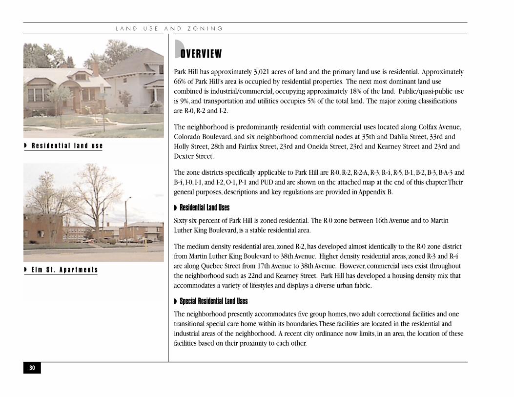
◗ Residential Land Uses
Sixty-six percent of Park Hill is zoned residential. The R-0 zone between 16th Avenue and to MartinLuther King Boulevard, is a stable residential area.
The medium density residential area, zoned R-2, has developed almost identically to the R-0 zone districtfrom Martin Luther King Boulevard to 38th Avenue. Higher density residential areas, zoned R-3 and R-4are along Quebec Street from 17th Avenue to 38th Avenue. However, commercial uses exist throughoutthe neighborhood such as 22nd and Kearney Street. Park Hill has developed a housing density mix thataccommodates a variety of lifestyles and displays a diverse urban fabric.
◗ Special Residential Land Uses
The neighborhood presently accommodates five group homes, two adult correctional facilities and onetransitional special care home within its boundaries.These facilities are located in the residential andindustrial areas of the neighborhood. A recent city ordinance now limits, in an area, the location of thesefacilities based on their proximity to each other.
30
◗ R e s i d e n t i a l l a n d u s e
◗ E l m S t . A p a r t m e n t s
P A R K H I L L N E I G H B O R H O O D P L A N
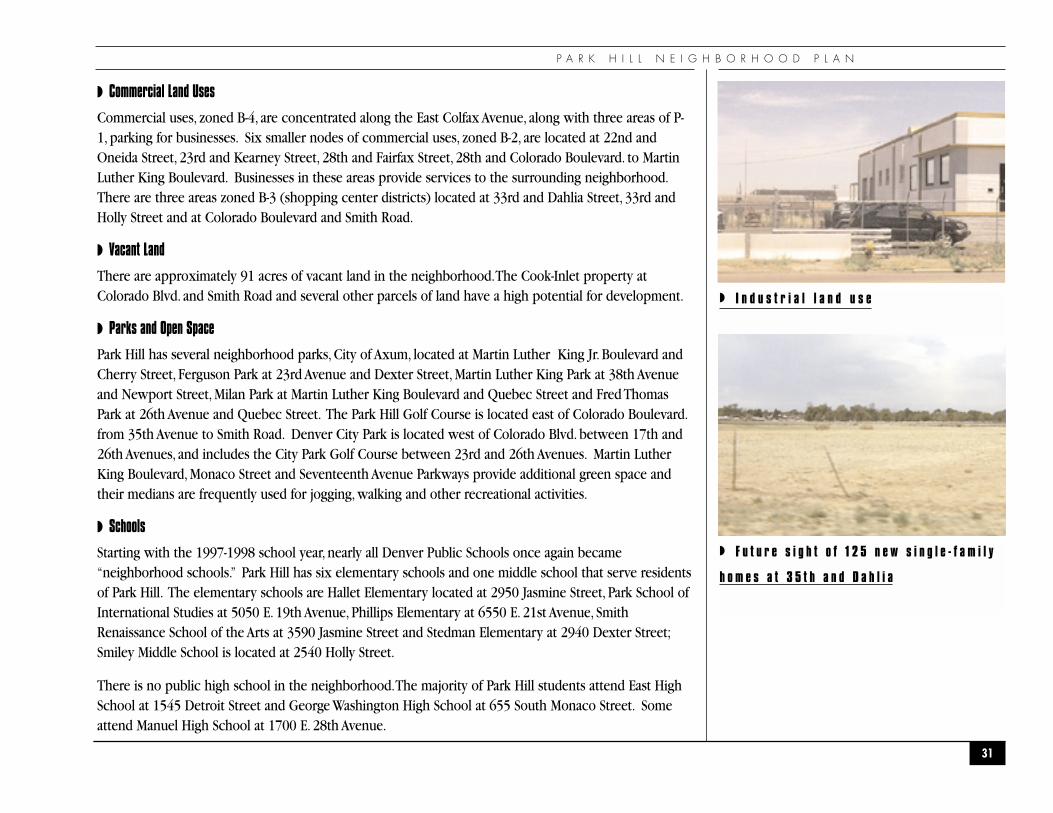
◗ Commercial Land Uses
Commercial uses, zoned B-4, are concentrated along the East Colfax Avenue, along with three areas of P-1, parking for businesses. Six smaller nodes of commercial uses, zoned B-2, are located at 22nd andOneida Street, 23rd and Kearney Street, 28th and Fairfax Street, 28th and Colorado Boulevard. to MartinLuther King Boulevard. Businesses in these areas provide services to the surrounding neighborhood.There are three areas zoned B-3 (shopping center districts) located at 33rd and Dahlia Street, 33rd andHolly Street and at Colorado Boulevard and Smith Road.
◗ Vacant Land
There are approximately 91 acres of vacant land in the neighborhood.The Cook-Inlet property atColorado Blvd. and Smith Road and several other parcels of land have a high potential for development.
◗ Parks and Open Space
Park Hill has several neighborhood parks, City of Axum, located at Martin Luther King Jr. Boulevard andCherry Street, Ferguson Park at 23rd Avenue and Dexter Street, Martin Luther King Park at 38th Avenueand Newport Street, Milan Park at Martin Luther King Boulevard and Quebec Street and Fred ThomasPark at 26th Avenue and Quebec Street. The Park Hill Golf Course is located east of Colorado Boulevard.from 35th Avenue to Smith Road. Denver City Park is located west of Colorado Blvd. between 17th and26th Avenues, and includes the City Park Golf Course between 23rd and 26th Avenues. Martin LutherKing Boulevard, Monaco Street and Seventeenth Avenue Parkways provide additional green space andtheir medians are frequently used for jogging, walking and other recreational activities.
◗ Schools
Starting with the 1997-1998 school year, nearly all Denver Public Schools once again became“neighborhood schools.” Park Hill has six elementary schools and one middle school that serve residentsof Park Hill. The elementary schools are Hallet Elementary located at 2950 Jasmine Street, Park School ofInternational Studies at 5050 E. 19th Avenue, Phillips Elementary at 6550 E. 21st Avenue, SmithRenaissance School of the Arts at 3590 Jasmine Street and Stedman Elementary at 2940 Dexter Street;Smiley Middle School is located at 2540 Holly Street.
There is no public high school in the neighborhood.The majority of Park Hill students attend East HighSchool at 1545 Detroit Street and George Washington High School at 655 South Monaco Street. Someattend Manuel High School at 1700 E. 28th Avenue.
31
◗ I n d u s t r i a l l a n d u s e
◗ F u t u r e s i g h t o f 1 2 5 n e w s i n g l e - f a m i l y
h o m e s a t 3 5 t h a n d D a h l i a
L A N D U S E A N D Z O N I N G
Park Hill has various private schools including Blessed Sacrament Catholic School located at 1973 ElmStreet, Union Baptist Church Excel Institute at 3200 Dahlia Street,The Odyssey Charter School at 19thand Elm Street, and the University of Denver Park Hill Campus, which includes the law school andHouston fine arts center, is located at 7039 E. 18th Avenue. The Denver University facilities will berelocating outside of the neighborhood and will be replaced by Johnson and Wales University and thenew Denver Public High School for the Performing Arts.
◗ Goals
◗ Maintain the existing integrity of the residential character of Park Hill.Assure that continuedgrowth and development in Park Hill results in a balanced and compatible mix of housing types and densities.
◗ Oppose industrial expansion outside the areas currently zoned for industrial uses north of 38th Avenue, from Colorado Boulevard to Quebec Street. Explore opportunities for live/work.
◗ Minimize the visual impacts and create an improved buffer area between the industrial,commercial and residential areas.
◗ Maintain and enhance the small-scale neighborhood character of the business areas and fosterthe development of “Main Street” type imagery.
◗ Preserve the existing parks and open space within the neighborhood.
◗ Preserve the areas of historical significance through historic districts or historic landmark designation.
◗ Maintain and enhance the viability of residential and commercial land uses on Colorado Boulevard.
◗ Identify and change non-conforming land uses in the neighborhood.
32
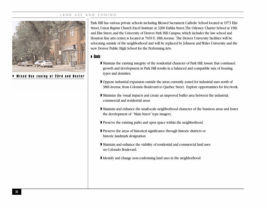
◗ M i x e d U s e z o n i n g a t 2 3 r d a n d D e x t e r
P A R K H I L L N E I G H B O R H O O D P L A N
◗ Action Recommendations
The action recommendations have been divided into on-going, short term and long term. On-goingrecommendations can be started immediately and continue. Short-term recommendations can be startedimmediately with limited resources or no money. Long-term recommendations will take longer toaccomplish and will require funding.
The neighborhood selected three projects from each policy area as “top priorities” for implementation.
1. LZ-10 Notify and participate in the redevelopment of the Dahlia and Holly shopping centers. Workwith landowners and the city on any rezoning proposals and related site plan issues.
2. LZ-8 Encourage enforcement of city ordinance requirements for absentee landlords to have an agentregistered with the Assessment Division. As a part of that effort, the name and addresses ofowners and agents listed by the assessor’s records should be corrected.
3. LZ-3 Create and maintain a mix of housing types and sizes that are attractive and affordable to adiversity of ages, incomes, household types, sizes, cultural and ethnic backgrounds.
3. LZ-1 Encourage the citywide dispersal of group homes and subsidized housing.
33
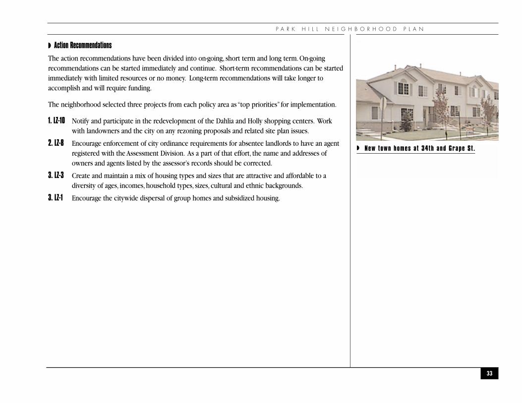
◗ New town homes at 34th and Grape St .
L A N D U S E A N D Z O N I N G A C T I O N C H A R T
34
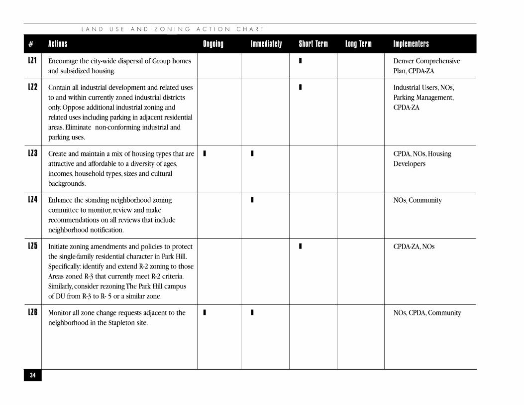
# Actions Ongoing Immediately Short Term Long Term Implementers
LZ1 Encourage the city-wide dispersal of Group homes ❚ Denver Comprehensiveand subsidized housing. Plan, CPDA-ZA
LZ2 Contain all industrial development and related uses ❚ Industrial Users, NOs,to and within currently zoned industrial districts Parking Management,only. Oppose additional industrial zoning and CPDA-ZArelated uses including parking in adjacent residentialareas. Eliminate non-conforming industrial and parking uses.
LZ3 Create and maintain a mix of housing types that are ❚ ❚ CPDA, NOs, Housingattractive and affordable to a diversity of ages, Developersincomes, household types, sizes and cultural backgrounds.
LZ4 Enhance the standing neighborhood zoning ❚ NOs, Communitycommittee to monitor, review and make recommendations on all reviews that include neighborhood notification.
LZ5 Initiate zoning amendments and policies to protect ❚ CPDA-ZA, NOsthe single-family residential character in Park Hill.Specifically: identify and extend R-2 zoning to those Areas zoned R-3 that currently meet R-2 criteria.Similarly, consider rezoning The Park Hill campus of DU from R-3 to R- 5 or a similar zone.
LZ6 Monitor all zone change requests adjacent to the ❚ ❚ NOs, CPDA, Community neighborhood in the Stapleton site.
P A R K H I L L N E I G H B O R H O O D P L A N
35
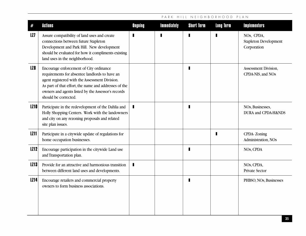
# Actions Ongoing Immediately Short Term Long Term Implementers
LZ7 Assure compatibility of land uses and create ❚ ❚ ❚ ❚ NOs, CPDA,connections between future Stapleton Stapleton DevelopmentDevelopment and Park Hill. New development Corporationshould be evaluated for how it compliments existingland uses in the neighborhood.
LZ8 Encourage enforcement of City ordinance ❚ Assessment Division,requirements for absentee landlords to have an CPDA-NIS, and NOsagent registered with the Assessment Division.As part of that effort, the name and addresses of theowners and agents listed by the Assessor’s records should be corrected.
LZ10 Participate in the redevelopment of the Dahlia and ❚ ❚ NOs, Businesses,Holly Shopping Centers. Work with the landowners DURA and CPDA-H&NDSand city on any rezoning proposals and related site plan issues.
LZ11 Participate in a citywide update of regulations for ❚ CPDA- Zoning home occupation businesses. Administration, NOs
LZ12 Encourage participation in the citywide Land use ❚ NOs, CPDAand Transportation plan.
LZ13 Provide for an attractive and harmonious transition ❚ NOs, CPDA,between different land uses and developments. Private Sector
LZ14 Encourage retailers and commercial property ❚ PHBSO, NOs, Businessesowners to form business associations.
L A N D U S E A N D Z O N I N G A C T I O N C H A R T
36
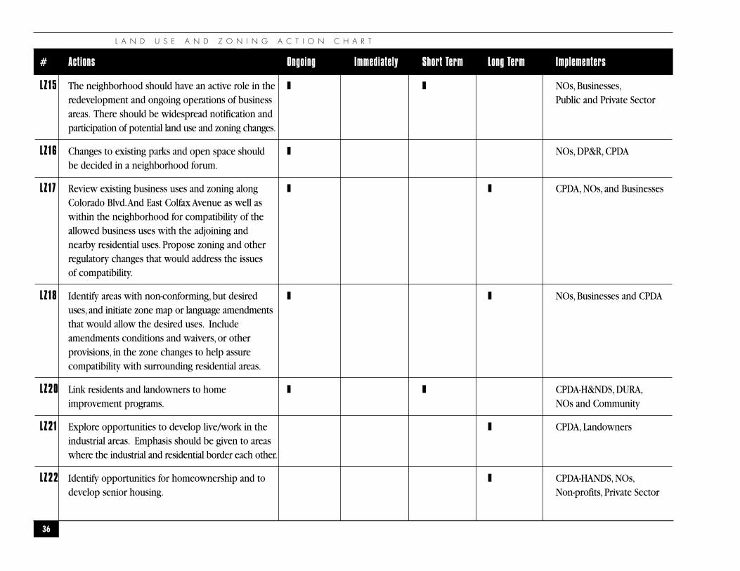
# Actions Ongoing Immediately Short Term Long Term Implementers
LZ15 The neighborhood should have an active role in the ❚ ❚ NOs, Businesses,redevelopment and ongoing operations of business Public and Private Sectorareas. There should be widespread notification and participation of potential land use and zoning changes.
LZ16 Changes to existing parks and open space should ❚ NOs, DP&R, CPDAbe decided in a neighborhood forum.
LZ17 Review existing business uses and zoning along ❚ ❚ CPDA, NOs, and BusinessesColorado Blvd.And East Colfax Avenue as well as within the neighborhood for compatibility of the allowed business uses with the adjoining and nearby residential uses. Propose zoning and other regulatory changes that would address the issues of compatibility.
LZ18 Identify areas with non-conforming, but desired ❚ ❚ NOs, Businesses and CPDAuses, and initiate zone map or language amendments that would allow the desired uses. Include amendments conditions and waivers, or otherprovisions, in the zone changes to help assure compatibility with surrounding residential areas.
LZ20 Link residents and landowners to home ❚ ❚ CPDA-H&NDS, DURA,improvement programs. NOs and Community
LZ21 Explore opportunities to develop live/work in the ❚ CPDA, Landownersindustrial areas. Emphasis should be given to areas where the industrial and residential border each other.
LZ22 Identify opportunities for homeownership and to ❚ CPDA-HANDS, NOs,develop senior housing. Non-profits, Private Sector
P A R K H I L L N E I G H B O R H O O D P L A N
37
R-4
R-0
R-2
R-0
R-0 R-0
R-2 R-2
B-2
I-2 I-2
I-1
I-0
B-3
O-1
1-0B-3
PUDPUD
B-2 B-2
B-2
R-2 R-2
R-2-AR-2-A
B-1 B-3
B-2B-2R-4
R-4
R-4
R-3
B-2
P-1
P-1
B-4
B-1
B-A-3
B-4
B-4 B-4B-4
R-5
R-3P-1
PUD
B-1
OCTOBER 1999
Interstate 70
38th Ave.
Smith Rd.
35th Ave.
34th Ave.
Martin Luther King Blvd.
23rd Ave.
Montview Blvd.
26th Ave.
17th Ave. Pkwy.
Colfax Ave.
48th Ave.
Colo
rado
Blv
d.
Dahl
ia S
t.
Elm
St.
Holly
St.
Mon
aco
St. P
kwy.
Queb
ec S
t.
28th Ave.
52nd Ave.
N
◗ P a r k H i l l L a n d U s e M a p
0-1
I-0
I-1
I-2
B-1
B-2
B-1
B-A-3
R-0
R-2
R-2-A
R-3
PUDR-4
P-1
U R B A N D E S I G N
38
�U R B A N D E S I G N�
“If you foolishly ignore beauty, you’ll soon find yourself without it. Your life will be impoverished. But if you wisely invest in beauty, it will remain with you all the days of your life”
— Frank Lloyd Wright
P A R K H I L L N E I G H B O R H O O D P L A N
◗OVERVIEW
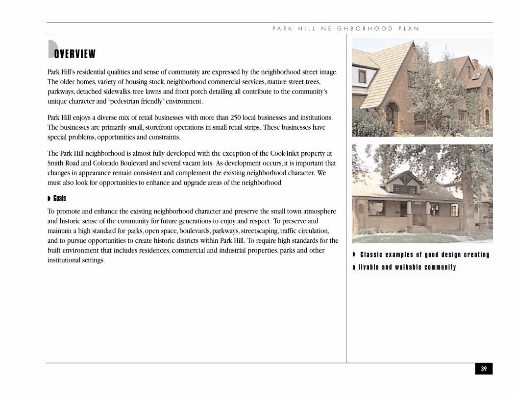
Park Hill’s residential qualities and sense of community are expressed by the neighborhood street image.The older homes, variety of housing stock, neighborhood commercial services, mature street trees,parkways, detached sidewalks, tree lawns and front porch detailing all contribute to the community’sunique character and “pedestrian friendly”environment.
Park Hill enjoys a diverse mix of retail businesses with more than 250 local businesses and institutions.The businesses are primarily small, storefront operations in small retail strips. These businesses havespecial problems, opportunities and constraints.
The Park Hill neighborhood is almost fully developed with the exception of the Cook-Inlet property atSmith Road and Colorado Boulevard and several vacant lots. As development occurs, it is important thatchanges in appearance remain consistent and complement the existing neighborhood character. Wemust also look for opportunities to enhance and upgrade areas of the neighborhood.
◗ Goals
To promote and enhance the existing neighborhood character and preserve the small town atmosphereand historic sense of the community for future generations to enjoy and respect. To preserve andmaintain a high standard for parks, open space, boulevards, parkways, streetscaping, traffic circulation,and to pursue opportunities to create historic districts within Park Hill. To require high standards for thebuilt environment that includes residences, commercial and industrial properties, parks and otherinstitutional settings.
39
◗ C l a s s i c e x a m p l e s o f g o o d d e s i g n c r e a t i n g
a l i v a b l e a n d w a l k a b l e c o m m u n i t y
U R B A N D E S I G N
◗ Action Recommendations
The action recommendations have been divided into on-going, short term and long term. On-goingrecommendations can be started immediately and continue. Short-term recommendations can be startedimmediately with limited resources or no money. Long-term recommendations will take longer toaccomplish and will require funding.
The neighborhood selected three projects from each policy area as “top priorities” for implementation.
1. UD-2 Educate residents, businesses and developers about the “neighborhood voluntary design guidelines.” (see Appendix A)
2. UD-8 Develop and apply a process for neighborhood review of projects pertaining to parks and openspace, boulevards, parkways, streetscaping, traffic circulation, special improvements and historicdistricts within Park Hill as they pertain to the neighborhood's urban design.
2. UD-13 Work with Stapleton Development Corporation (SDC) and Forest City to insure goodconnections between Park Hill and new developments at Stapleton.
3. UD-14 Work with SDC and Transportation Engineering to mitigate the impacts on the neighborhood forthe future expansion of Quebec Street.
40
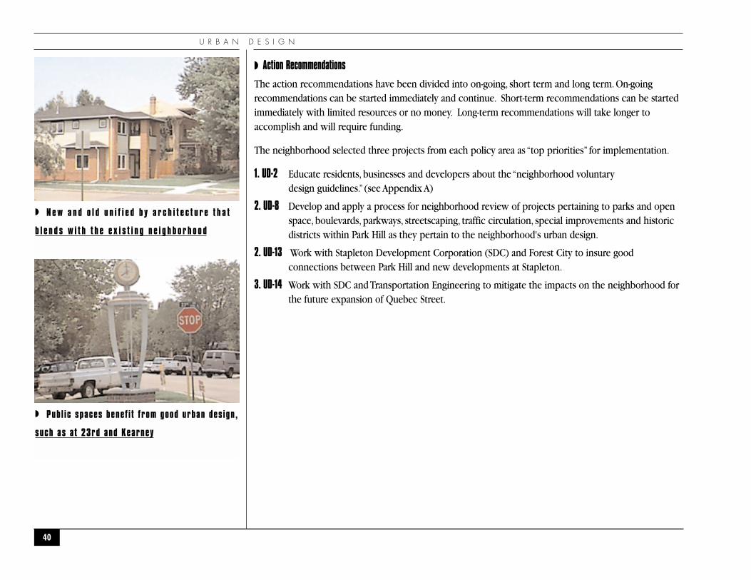
◗ N e w a n d o l d u n i f i e d b y a r c h i t e c t u r e t h a t
b l e n d s w i t h t h e e x i s t i n g n e i g h b o r h o o d
◗ Publ ic spaces benef i t from good urban des ign,
such as at 23rd and Kearney
P A R K H I L L N E I G H B O R H O O D P L A N
41
# Actions Ongoing Immediately Short Term Long Term Implementers
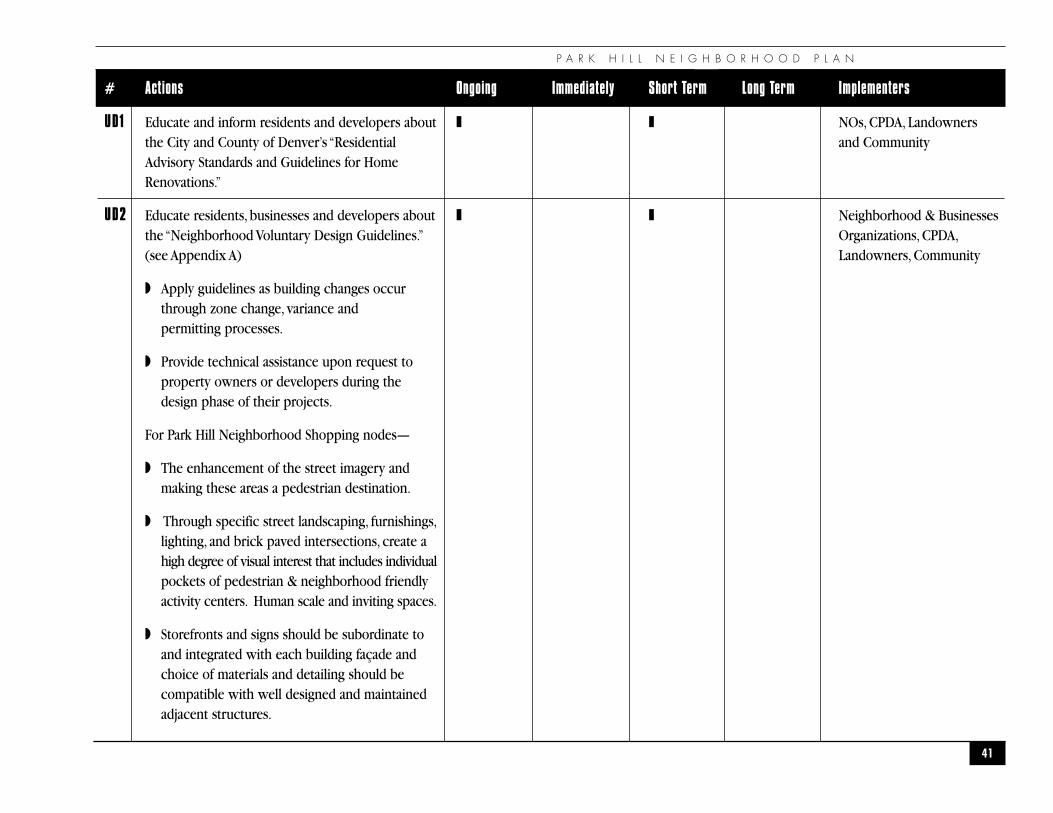
UD1 Educate and inform residents and developers about ❚ ❚ NOs, CPDA, Landownersthe City and County of Denver’s “Residential and CommunityAdvisory Standards and Guidelines for Home Renovations.”
UD2 Educate residents, businesses and developers about ❚ ❚ Neighborhood & Businessesthe “Neighborhood Voluntary Design Guidelines.” Organizations, CPDA,(see Appendix A) Landowners, Community
◗ Apply guidelines as building changes occur through zone change, variance and permitting processes.
◗ Provide technical assistance upon request to property owners or developers during the design phase of their projects.
For Park Hill Neighborhood Shopping nodes—
◗ The enhancement of the street imagery and making these areas a pedestrian destination.
◗ Through specific street landscaping, furnishings,lighting, and brick paved intersections, create a high degree of visual interest that includes individualpockets of pedestrian & neighborhood friendly activity centers. Human scale and inviting spaces.
◗ Storefronts and signs should be subordinate to and integrated with each building façade and choice of materials and detailing should be compatible with well designed and maintained adjacent structures.
U R B A N D E S I G N A C T I O N C H A R T
42
# Actions Ongoing Immediately Short Term Long Term Implementers
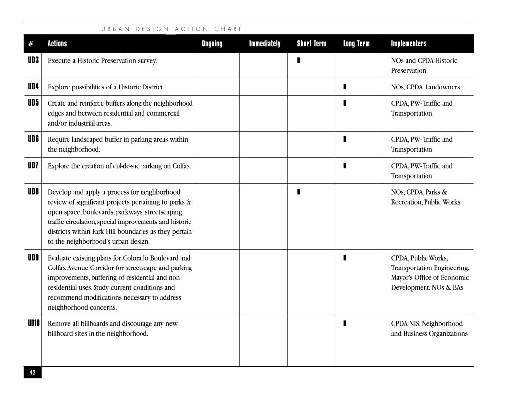
UD3 Execute a Historic Preservation survey. ❚ NOs and CPDA-Historic Preservation
UD4 Explore possibilities of a Historic District. ❚ NOs, CPDA, Landowners
UD5 Create and reinforce buffers along the neighborhood ❚ CPDA, PW- Traffic andedges and between residential and commercial Transportationand/or industrial areas.
UD6 Require landscaped buffer in parking areas within ❚ CPDA, PW- Traffic andthe neighborhood. Transportation
UD7 Explore the creation of cul-de-sac parking on Colfax. ❚ CPDA, PW- Traffic andTransportation
UD8 Develop and apply a process for neighborhood ❚ NOs, CPDA, Parks & review of significant projects pertaining to parks & Recreation, Public Worksopen space, boulevards, parkways, streetscaping,traffic circulation, special improvements and historicdistricts within Park Hill boundaries as they pertain to the neighborhood’s urban design.
UD9 Evaluate existing plans for Colorado Boulevard and ❚ CPDA, Public Works,Colfax Avenue Corridor for streetscape and parking Transportation Engineering,improvements, buffering of residential and non- Mayor’s Office of Economicresidential uses. Study current conditions and Development, NOs & BAsrecommend modifications necessary to address neighborhood concerns.
UD10 Remove all billboards and discourage any new ❚ CPDA-NIS, Neighborhoodbillboard sites in the neighborhood. and Business Organizations
P A R K H I L L N E I G H B O R H O O D P L A N
43
# Actions Ongoing Immediately Short Term Long Term Implementers
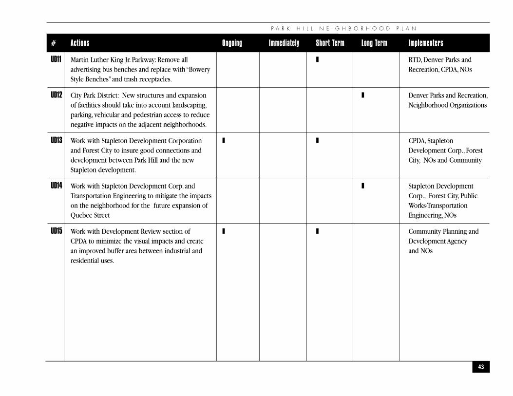
UD11 Martin Luther King Jr. Parkway: Remove all ❚ RTD, Denver Parks andadvertising bus benches and replace with “Bowery Recreation, CPDA, NOs Style Benches”and trash receptacles.
UD12 City Park District: New structures and expansion ❚ Denver Parks and Recreation,of facilities should take into account landscaping, Neighborhood Organizationsparking, vehicular and pedestrian access to reducenegative impacts on the adjacent neighborhoods.
UD13 Work with Stapleton Development Corporation ❚ ❚ CPDA, Stapleton and Forest City to insure good connections and Development Corp., Forest development between Park Hill and the new City, NOs and CommunityStapleton development.
UD14 Work with Stapleton Development Corp. and ❚ Stapleton Development Transportation Engineering to mitigate the impacts Corp., Forest City, Public on the neighborhood for the future expansion of Works-Transportation Quebec Street Engineering, NOs
UD15 Work with Development Review section of ❚ ❚ Community Planning and CPDA to minimize the visual impacts and create Development Agency an improved buffer area between industrial and and NOs residential uses.

P U B L I C S A F E T Y
44
�P U B L I C S A F E T Y�
“Our lives begin to end the day we become silent about things that matter.”
— Martin Luther King Jr.
P A R K H I L L N E I G H B O R H O O D P L A N
◗OVERVIEW
Public safety is as much about encouraging the desirable uses of a place as it is about discouragingundesirable or criminal uses. A lower crime rate is both a cause and an effect of a good quality of life inour community. Park Hill struggles with vandalism, graffiti, alley and mid-block street lighting,unreported crimes, drug and gang presence and disturbances. More importantly, a lack ofinterest/involvement by some property owners and managers, especially, absentee owners and managershas a direct impact in the overall quality of life in the neighborhood.
◗ Goals
Reduce crime in Park Hill so residents feel safe in their homes, on neighborhood streets and in their open spaces.
◗ Objectives
1 Encourage better communication between youths, parents, schools and police in the neighborhood.
2 Rid the neighborhood of drug houses and gangs.
3 Support efforts made by the city, property owners, residents and neighborhood organizations of Park Hill to reduce crime.
4 Ensure the safety of the more vulnerable members of the community—children and the elderly.
5 Improve lighting on neighborhood streets, alleys and open spaces.
6 Explore ways for those convicted of crimes to do community service work that benefits thecommunity.
7 Improve security for single family and multi-family residents.
8 Improve security in retail areas by encouraging pedestrian traffic.
45
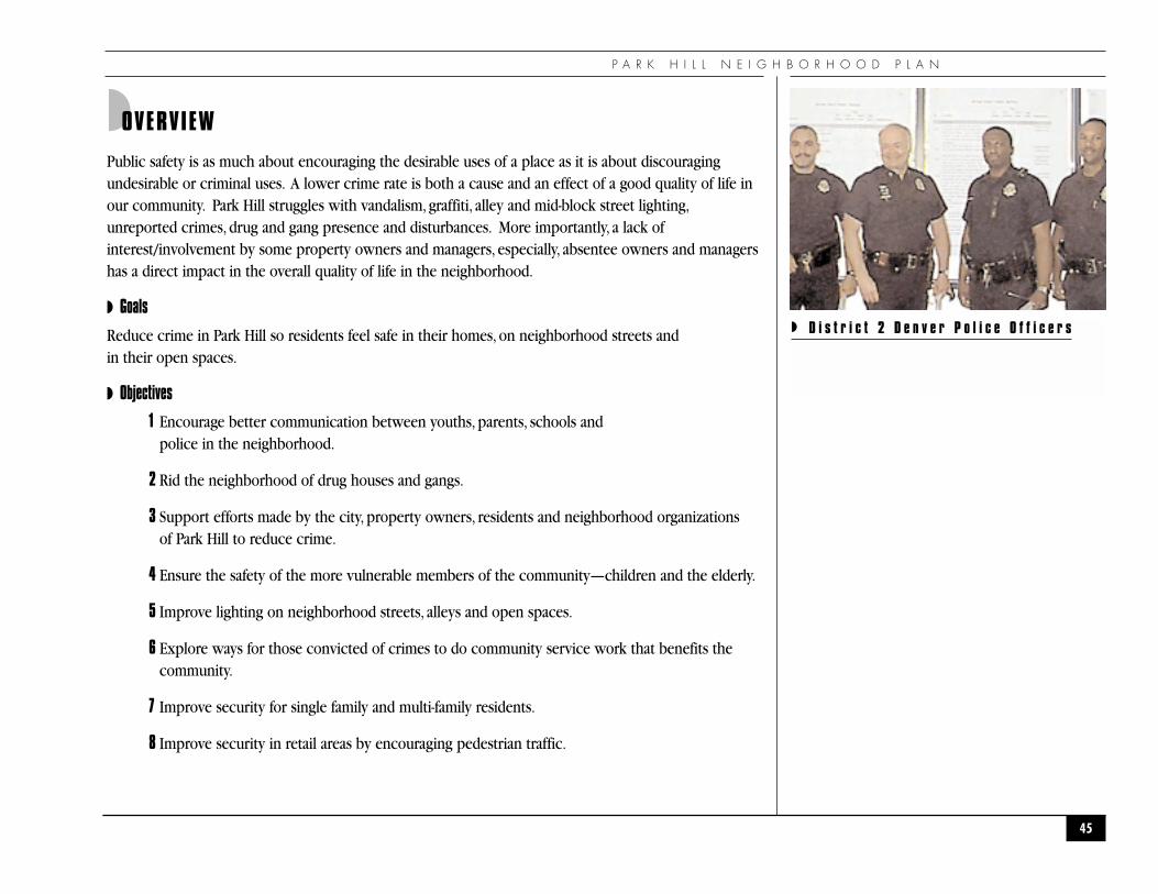
◗ D i s t r i c t 2 D e n v e r P o l i c e O f f i c e r s
P U B L I C S A F E T Y
◗ Action Recommendations
The action recommendations have been divided into on-going, short term and long term. On-goingrecommendations can be started immediately and continue. Short-term recommendations can be startedimmediately with limited resources or no money. Long-term recommendations will take longer toaccomplish and will require funding.
The neighborhood selected three projects from each policy area as “top priorities” for implementation.
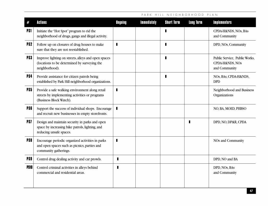
1. PS-14 Identify and inventory the problem areas, such as apartment buildings and businesses havingfrequent reports of crimes. Work with owners, managers and other city agencies to deal withsuch concerns. Encourage 100% participation of all apartment managers to participate in thePolice Departments “Management Training Program.”
2. PS-10 Control criminal activities in alleys behind commercial and residential areas.
3. PS-12 Achieve 100% participation of all blocks in the “Neighborhood Watch Program.”
3. PS-3 Improve lighting on streets, in alleys and open spaces. (locations will be determined by surveying the neighborhood)
46
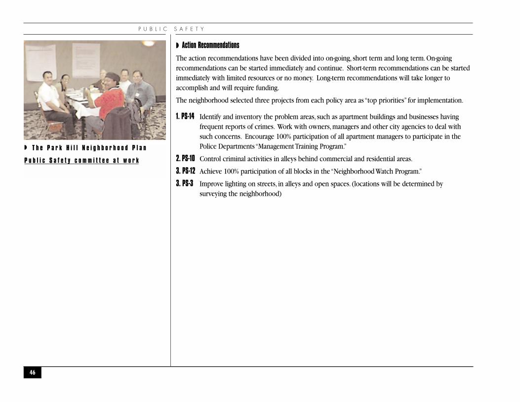
◗ T h e P a r k H i l l N e i g h b o r h o o d P l a n
P u b l i c S a f e t y c o m m i t t e e a t w o r k
P A R K H I L L N E I G H B O R H O O D P L A N
47
# Actions Ongoing Immediately Short Term Long Term Implementers
PS1 Initiate the “Hot Spot”program to rid the ❚ CPDA-H&NDS, NOs, BAsneighborhood of drugs, gangs and illegal activity. and Community
PS2 Follow up on closures of drug houses to make ❚ ❚ DPD, NOs, Communitysure that they are not reestablished.
PS3 Improve lighting on streets, alleys and open spaces ❚ Public Service, Public Works,(locations to be determined by surveying the CPDA-H&NDS, NOs neighborhood). and Community
PS4 Provide assistance for citizen patrols being ❚ NOs, BAs, CPDA-H&NDS,established by Park Hill neighborhood organizations. DPD
PS5 Provide a safe walking environment along retail ❚ Neighborhood and Business streets by implementing activities or programs Organizations(Business Block Watch).
PS6 Support the success of individual shops. Encourage ❚ NO, BA, MOED, PHBSO and recruit new businesses in empty storefronts.
PS7 Design and maintain security in parks and open ❚ DPD, NO, DP&R, CPDAspace by increasing bike patrols, lighting, and reducing unsafe spaces.
PS8 Encourage periodic organized activities in parks ❚ NOs and Communityand open spaces such as picnics, parties and community gatherings.
PS9 Control drug dealing activity and car prowls. ❚ DPD, NO and BA
PS10 Control criminal activities in alleys behind ❚ DPD, NOs, BAscommercial and residential areas. and Community
P U B L I C S A F E T Y A C T I O N C H A R T
48
# Actions Ongoing Immediately Short Term Long Term Implementers
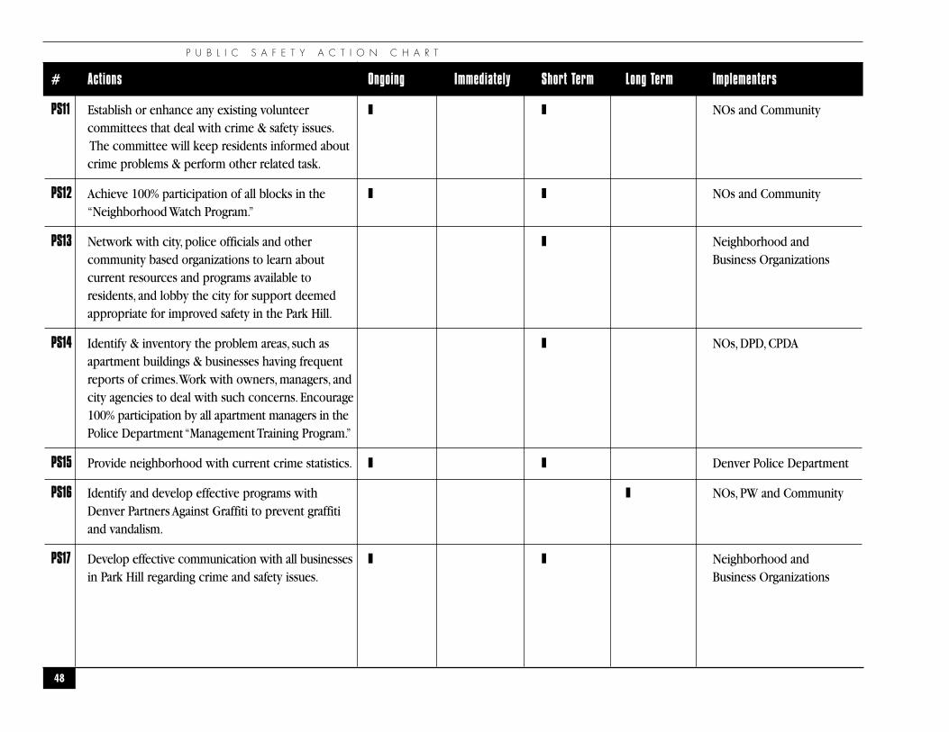
PS11 Establish or enhance any existing volunteer ❚ ❚ NOs and Communitycommittees that deal with crime & safety issues.The committee will keep residents informed about crime problems & perform other related task.
PS12 Achieve 100% participation of all blocks in the ❚ ❚ NOs and Community“Neighborhood Watch Program.”
PS13 Network with city, police officials and other ❚ Neighborhood andcommunity based organizations to learn about Business Organizationscurrent resources and programs available toresidents, and lobby the city for support deemed appropriate for improved safety in the Park Hill.
PS14 Identify & inventory the problem areas, such as ❚ NOs, DPD, CPDAapartment buildings & businesses having frequent reports of crimes.Work with owners, managers, and city agencies to deal with such concerns. Encourage 100% participation by all apartment managers in thePolice Department “Management Training Program.”
PS15 Provide neighborhood with current crime statistics. ❚ ❚ Denver Police Department
PS16 Identify and develop effective programs with ❚ NOs, PW and CommunityDenver Partners Against Graffiti to prevent graffiti and vandalism.
PS17 Develop effective communication with all businesses ❚ ❚ Neighborhood andin Park Hill regarding crime and safety issues. Business Organizations
P A R K H I L L N E I G H B O R H O O D P L A N
49
# Actions Ongoing Immediately Short Term Long Term Implementers
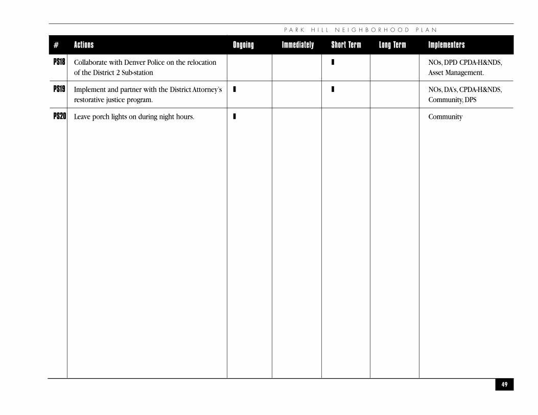
PS18 Collaborate with Denver Police on the relocation ❚ NOs, DPD CPDA-H&NDS,of the District 2 Sub-station Asset Management.
PS19 Implement and partner with the District Attorney’s ❚ ❚ NOs, DA’s, CPDA-H&NDS,restorative justice program. Community, DPS
PS20 Leave porch lights on during night hours. ❚ Community
B U S I N E S S A N D E C O N O M I C D E V E L O P M E N T
50
�B U S I N E S S A N D E C O N O M I C D E V E L O P M E N T
�
“Success usually comes to those who are too busy to be looking for it”
— Henry David Thoreau
P A R K H I L L N E I G H B O R H O O D P L A N
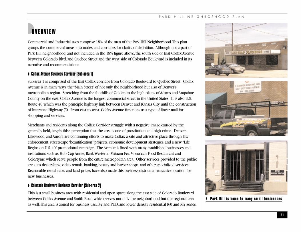
◗OVERVIEW
Commercial and Industrial uses comprise 18% of the area of the Park Hill Neighborhood.This plangroups the commercial areas into nodes and corridors for clarity of definition. Although not a part ofPark Hill neighborhood, and not included in the 18% figure above, the south side of East Colfax Avenuebetween Colorado Blvd. and Quebec Street and the west side of Colorado Boulevard is included in itsnarrative and recommendations.
◗ Colfax Avenue Business Corridor (Sub-area 1)
Sub-area 1 is comprised of the East Colfax corridor from Colorado Boulevard to Quebec Street. ColfaxAvenue is in many ways the “Main Street”of not only the neighborhood but also of Denver’smetropolitan region. Stretching from the foothills of Golden to the high plains of Adams and ArapahoeCounty on the east, Colfax Avenue is the longest commercial street in the United States. It is also U.S.Route 40 which was the principle highway link between Denver and Kansas City until the constructionof Interstate Highway 70. From east to west, Colfax Avenue functions as a type of linear mall forshopping and services.
Merchants and residents along the Colfax Corridor struggle with a negative image caused by thegenerally-held, largely false perception that the area is one of prostitution and high crime. Denver,Lakewood, and Aurora are continuing efforts to make Colfax a safe and attractive place through lawenforcement, streetscape “beautification”projects, economic development strategies, and a new “LifeBegins on U.S. 40”promotional campaign. The Avenue is lined with many established businesses andinstitutions such as Hub Cap Annie, Bank Western, Mataam Fez Moroccan Food Restaurant andColortyme which serve people from the entire metropolitan area. Other services provided to the publicare auto dealerships, video rentals, banking, beauty and barber shops, and other specialized services.Reasonable rental rates and land prices have also made this business district an attractive location fornew businesses.
◗ Colorado Boulevard Business Corridor (Sub-area 2)
This is a small business area with residential and open space along the east side of Colorado Boulevardbetween Colfax Avenue and Smith Road which serves not only the neighborhood but the regional areaas well.This area is zoned for business use, B-2 and PUD, and lower density residential R-0 and R-2 zones.
51
◗ Park H i l l is home to many smal l bus inesses
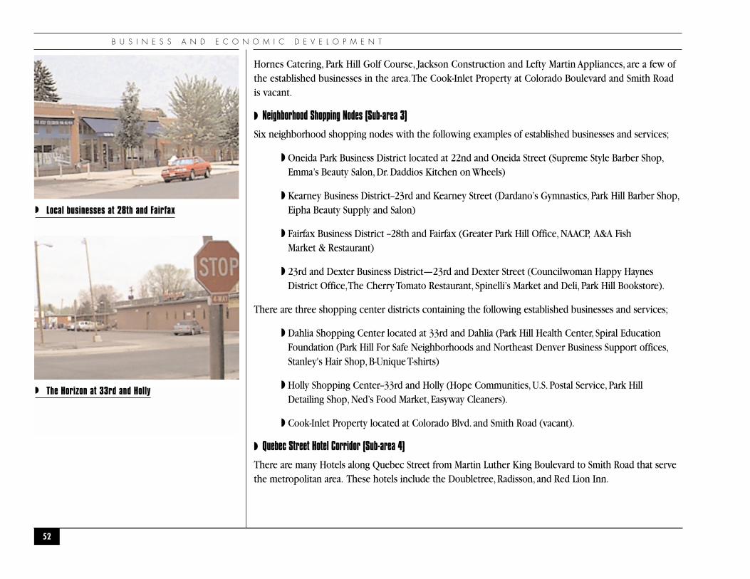
B U S I N E S S A N D E C O N O M I C D E V E L O P M E N T
Hornes Catering, Park Hill Golf Course, Jackson Construction and Lefty Martin Appliances, are a few ofthe established businesses in the area.The Cook-Inlet Property at Colorado Boulevard and Smith Roadis vacant.
◗ Neighborhood Shopping Nodes (Sub-area 3)
Six neighborhood shopping nodes with the following examples of established businesses and services;
◗ Oneida Park Business District located at 22nd and Oneida Street (Supreme Style Barber Shop,Emma’s Beauty Salon, Dr. Daddios Kitchen on Wheels)
◗ Kearney Business District--23rd and Kearney Street (Dardano’s Gymnastics, Park Hill Barber Shop,Eipha Beauty Supply and Salon)
◗ Fairfax Business District --28th and Fairfax (Greater Park Hill Office, NAACP, A&A Fish Market & Restaurant)
◗ 23rd and Dexter Business District—23rd and Dexter Street (Councilwoman Happy HaynesDistrict Office,The Cherry Tomato Restaurant, Spinelli’s Market and Deli, Park Hill Bookstore).
There are three shopping center districts containing the following established businesses and services;
◗ Dahlia Shopping Center located at 33rd and Dahlia (Park Hill Health Center, Spiral EducationFoundation (Park Hill For Safe Neighborhoods and Northeast Denver Business Support offices,Stanley's Hair Shop, B-Unique T-shirts)
◗ Holly Shopping Center--33rd and Holly (Hope Communities, U.S. Postal Service, Park HillDetailing Shop, Ned’s Food Market, Easyway Cleaners).
◗ Cook-Inlet Property located at Colorado Blvd. and Smith Road (vacant).
◗ Quebec Street Hotel Corridor (Sub-area 4)
There are many Hotels along Quebec Street from Martin Luther King Boulevard to Smith Road that servethe metropolitan area. These hotels include the Doubletree, Radisson, and Red Lion Inn.
52
◗ Local businesses at 28th and Fairfax
◗ The Horizon at 33rd and Holly
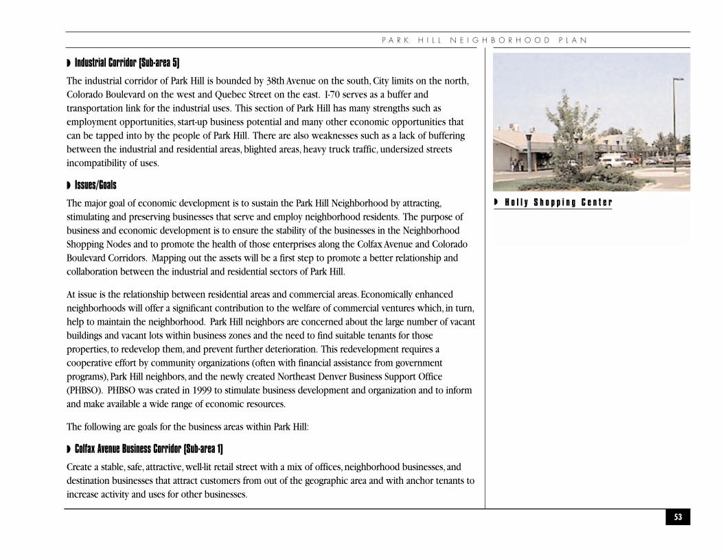
P A R K H I L L N E I G H B O R H O O D P L A N
◗ Industrial Corridor (Sub-area 5)
The industrial corridor of Park Hill is bounded by 38th Avenue on the south, City limits on the north,Colorado Boulevard on the west and Quebec Street on the east. I-70 serves as a buffer andtransportation link for the industrial uses. This section of Park Hill has many strengths such asemployment opportunities, start-up business potential and many other economic opportunities thatcan be tapped into by the people of Park Hill. There are also weaknesses such as a lack of bufferingbetween the industrial and residential areas, blighted areas, heavy truck traffic, undersized streetsincompatibility of uses.
◗ Issues/Goals
The major goal of economic development is to sustain the Park Hill Neighborhood by attracting,stimulating and preserving businesses that serve and employ neighborhood residents. The purpose ofbusiness and economic development is to ensure the stability of the businesses in the NeighborhoodShopping Nodes and to promote the health of those enterprises along the Colfax Avenue and ColoradoBoulevard Corridors. Mapping out the assets will be a first step to promote a better relationship andcollaboration between the industrial and residential sectors of Park Hill.
At issue is the relationship between residential areas and commercial areas. Economically enhancedneighborhoods will offer a significant contribution to the welfare of commercial ventures which, in turn,help to maintain the neighborhood. Park Hill neighbors are concerned about the large number of vacantbuildings and vacant lots within business zones and the need to find suitable tenants for thoseproperties, to redevelop them, and prevent further deterioration. This redevelopment requires acooperative effort by community organizations (often with financial assistance from governmentprograms), Park Hill neighbors, and the newly created Northeast Denver Business Support Office(PHBSO). PHBSO was crated in 1999 to stimulate business development and organization and to informand make available a wide range of economic resources.
The following are goals for the business areas within Park Hill:
◗ Colfax Avenue Business Corridor (Sub-area 1)
Create a stable, safe, attractive, well-lit retail street with a mix of offices, neighborhood businesses, anddestination businesses that attract customers from out of the geographic area and with anchor tenants toincrease activity and uses for other businesses.
53
◗ H o l l y S h o p p i n g C e n t e r
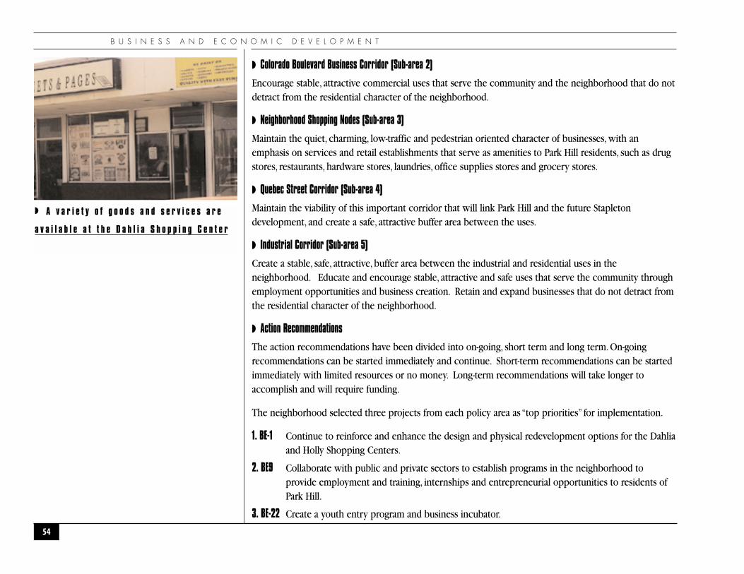
B U S I N E S S A N D E C O N O M I C D E V E L O P M E N T
◗ Colorado Boulevard Business Corridor (Sub-area 2)
Encourage stable, attractive commercial uses that serve the community and the neighborhood that do notdetract from the residential character of the neighborhood.
◗ Neighborhood Shopping Nodes (Sub-area 3)
Maintain the quiet, charming, low-traffic and pedestrian oriented character of businesses, with anemphasis on services and retail establishments that serve as amenities to Park Hill residents, such as drugstores, restaurants, hardware stores, laundries, office supplies stores and grocery stores.
◗ Quebec Street Corridor (Sub-area 4)
Maintain the viability of this important corridor that will link Park Hill and the future Stapletondevelopment, and create a safe, attractive buffer area between the uses.
◗ Industrial Corridor (Sub-area 5)
Create a stable, safe, attractive, buffer area between the industrial and residential uses in theneighborhood. Educate and encourage stable, attractive and safe uses that serve the community throughemployment opportunities and business creation. Retain and expand businesses that do not detract fromthe residential character of the neighborhood.
◗ Action Recommendations
The action recommendations have been divided into on-going, short term and long term. On-goingrecommendations can be started immediately and continue. Short-term recommendations can be startedimmediately with limited resources or no money. Long-term recommendations will take longer toaccomplish and will require funding.
The neighborhood selected three projects from each policy area as “top priorities” for implementation.
1. BE-1 Continue to reinforce and enhance the design and physical redevelopment options for the Dahliaand Holly Shopping Centers.
2. BE9 Collaborate with public and private sectors to establish programs in the neighborhood toprovide employment and training, internships and entrepreneurial opportunities to residents ofPark Hill.
3. BE-22 Create a youth entry program and business incubator.
54
◗ A v a r i e t y o f g o o d s a n d s e r v i c e s a r e
a v a i l a b l e a t t h e D a h l i a S h o p p i n g C e n t e r
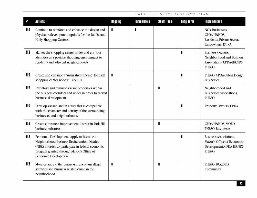
P A R K H I L L N E I G H B O R H O O D P L A N
55
# Actions Ongoing Immediately Short Term Long Term Implementers
BE1 Continue to reinforce and enhance the design and ❚ ❚ NOs, Businesses,physical redevelopment options for the Dahlia and CPDA-H&NDS,Holly Shopping Centers. Residents, Private Sector,
Landowners, DURA
BE2 Market the shopping center nodes and corridor ❚ Business Owners,identities as a positive shopping environment to Neighborhood and Businessresidents and adjacent neighborhoods Associations, CPDA-H&NDS
PHBSO
BE3 Create and enhance a “main street theme” for each ❚ ❚ PHBSO, CPDA-Urban Design,shopping center node in Park Hill. Businesses
BE4 Inventory and evaluate vacant properties within ❚ Neighborhood andthe business corridors and nodes in order to recruit Businesses Associations,business development. PHBSO
BE5 Develop vacant land in a way that is compatible ❚ Property Owners, CPDAwith the character and density of the surrounding businesses and neighborhoods.
BE6 Create a business improvement district in Park Hill ❚ CPDA-H&NDS, MOED,business sub-areas. PHBSO, Businesses
BE7 Economic Development--Apply to become a ❚ Business Associations,Neighborhood Business Revitalization District Mayor’s Office of Economic(NBR) in order to participate in federal economic Development,CPDA-H&NDS,program granted through Mayor’s Office of PHBSOEconomic Development.
BE8 Monitor and rid the business areas of any illegal ❚ ❚ PHBSO, BAs, DPD,activities and business related crime in the Communityneighborhood.
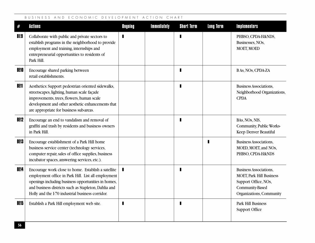
B U S I N E S S A N D E C O N O M I C D E V E L O P M E N T A C T I O N C H A R T
56
# Actions Ongoing Immediately Short Term Long Term Implementers
BE9 Collaborate with public and private sectors to ❚ ❚ PHBSO, CPDA-H&NDS,establish programs in the neighborhood to provide Businesses, NOs,employment and training, internships and MOET, MOEDentrepreneurial opportunities to residents of Park Hill.
BE10 Encourage shared parking between ❚ B As, NOs, CPDA-ZAretail establishments.
BE11 Aesthetics: Support pedestrian oriented sidewalks, ❚ Business Associations,streetscapes, lighting, human scale façade Neighborhood Organizations,improvements, trees, flowers, human scale CPDAdevelopment and other aesthetic enhancements that are appropriate for business sub-areas.
BE12 Encourage an end to vandalism and removal of ❚ BAs, NOs, NIS,graffiti and trash by residents and business owners Community, Public Works-in Park Hill. Keep Denver Beautiful
BE13 Encourage establishment of a Park Hill home ❚ Business Associations,business service center (technology services, MOED, MOET, and NOs,computer repair, sales of office supplies, business PHBSO, CPDA-H&NDSincubator spaces, answering services, etc.).
BE14 Encourage work close to home. Establish a satellite ❚ ❚ Business Associations,employment office in Park Hill. List all employment MOET, Park Hill Business openings including business opportunities in homes, Support Office, NOs,and business districts such as Stapleton, Dahlia and Community-Based Holly and the I-70 industrial business corridor. Organizations, Community
BE15 Establish a Park Hill employment web site. ❚ ❚ Park Hill BusinessSupport Office
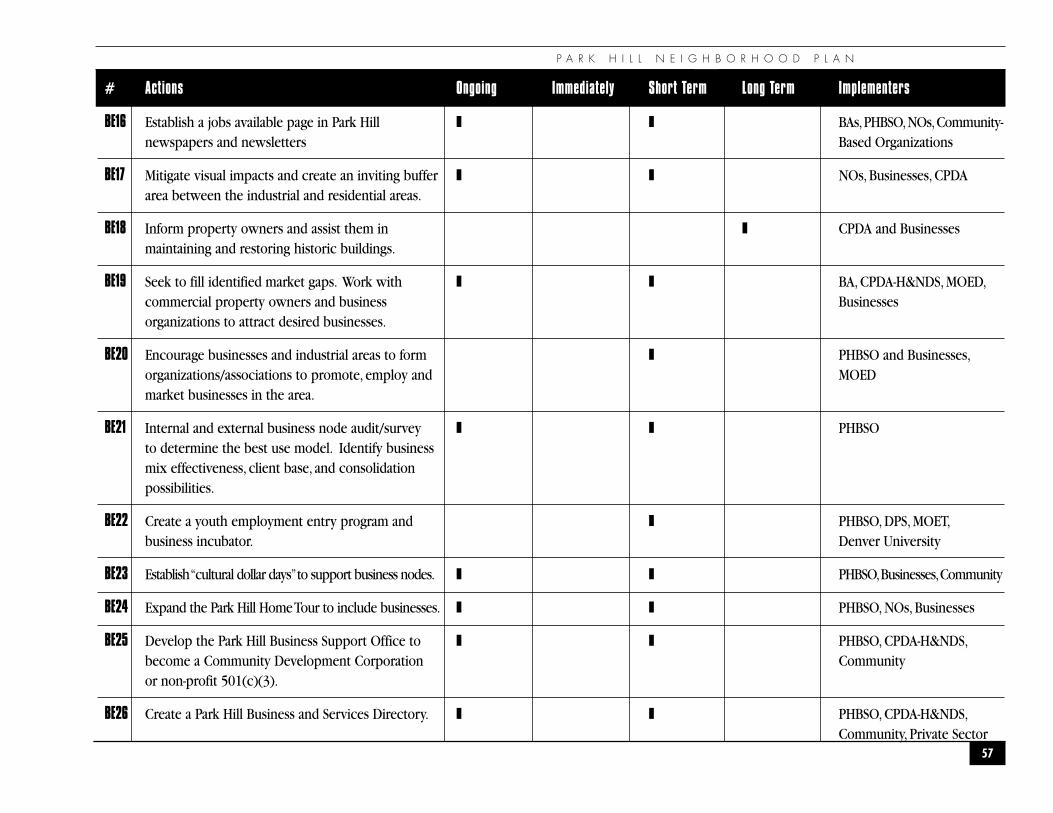
P A R K H I L L N E I G H B O R H O O D P L A N
57
# Actions Ongoing Immediately Short Term Long Term Implementers
BE16 Establish a jobs available page in Park Hill ❚ ❚ BAs,PHBSO,NOs,Community-newspapers and newsletters Based Organizations
BE17 Mitigate visual impacts and create an inviting buffer ❚ ❚ NOs, Businesses, CPDA area between the industrial and residential areas.
BE18 Inform property owners and assist them in ❚ CPDA and Businessesmaintaining and restoring historic buildings.
BE19 Seek to fill identified market gaps. Work with ❚ ❚ BA, CPDA-H&NDS, MOED,commercial property owners and business Businessesorganizations to attract desired businesses.
BE20 Encourage businesses and industrial areas to form ❚ PHBSO and Businesses,organizations/associations to promote, employ and MOEDmarket businesses in the area.
BE21 Internal and external business node audit/survey ❚ ❚ PHBSOto determine the best use model. Identify businessmix effectiveness, client base, and consolidationpossibilities.
BE22 Create a youth employment entry program and ❚ PHBSO, DPS, MOET,business incubator. Denver University
BE23 Establish “cultural dollar days”to support business nodes. ❚ ❚ PHBSO,Businesses,Community
BE24 Expand the Park Hill Home Tour to include businesses. ❚ ❚ PHBSO, NOs, Businesses
BE25 Develop the Park Hill Business Support Office to ❚ ❚ PHBSO, CPDA-H&NDS,become a Community Development Corporation Communityor non-profit 501(c)(3).
BE26 Create a Park Hill Business and Services Directory. ❚ ❚ PHBSO, CPDA-H&NDS,Community, Private Sector
H U M A N R E L A T I O N S A N D C O M M U N I T Y S E R V I C E S
58
�H U M A N R E L A T I O N S A N D C O M M U N I T Y S E R V I C E S
�
“We cannot seek achievement for ourselves and forget about progressand prosperity for our community...Our ambitions must be broadenough to include the aspirations and needs of others, for their sakesand for our own.”
— Cesar Chavez
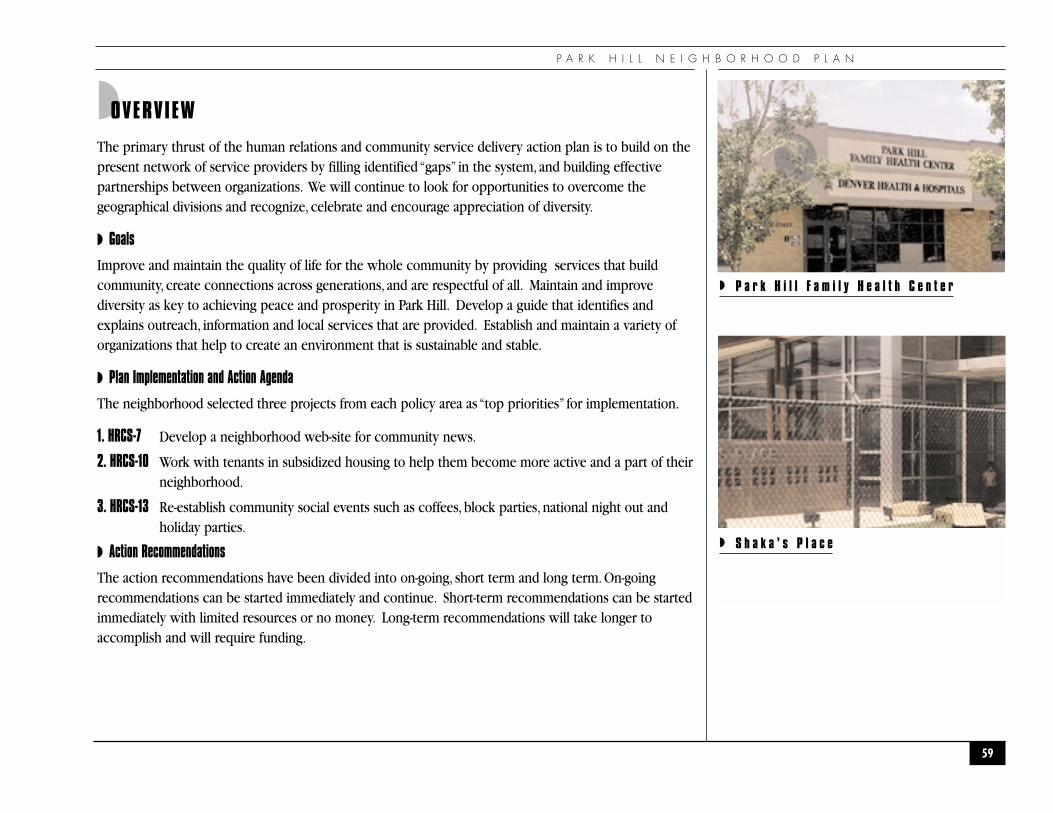
P A R K H I L L N E I G H B O R H O O D P L A N
◗OVERVIEW
The primary thrust of the human relations and community service delivery action plan is to build on thepresent network of service providers by filling identified “gaps” in the system, and building effectivepartnerships between organizations. We will continue to look for opportunities to overcome thegeographical divisions and recognize, celebrate and encourage appreciation of diversity.
◗ Goals
Improve and maintain the quality of life for the whole community by providing services that buildcommunity, create connections across generations, and are respectful of all. Maintain and improvediversity as key to achieving peace and prosperity in Park Hill. Develop a guide that identifies andexplains outreach, information and local services that are provided. Establish and maintain a variety oforganizations that help to create an environment that is sustainable and stable.
◗ Plan Implementation and Action Agenda
The neighborhood selected three projects from each policy area as “top priorities” for implementation.
1. HRCS-7 Develop a neighborhood web-site for community news.
2. HRCS-10 Work with tenants in subsidized housing to help them become more active and a part of theirneighborhood.
3. HRCS-13 Re-establish community social events such as coffees, block parties, national night out andholiday parties.
◗ Action Recommendations
The action recommendations have been divided into on-going, short term and long term. On-goingrecommendations can be started immediately and continue. Short-term recommendations can be startedimmediately with limited resources or no money. Long-term recommendations will take longer toaccomplish and will require funding.
59
◗ P a r k H i l l F a m i l y H e a l t h C e n t e r
◗ S h a k a ’ s P l a c e
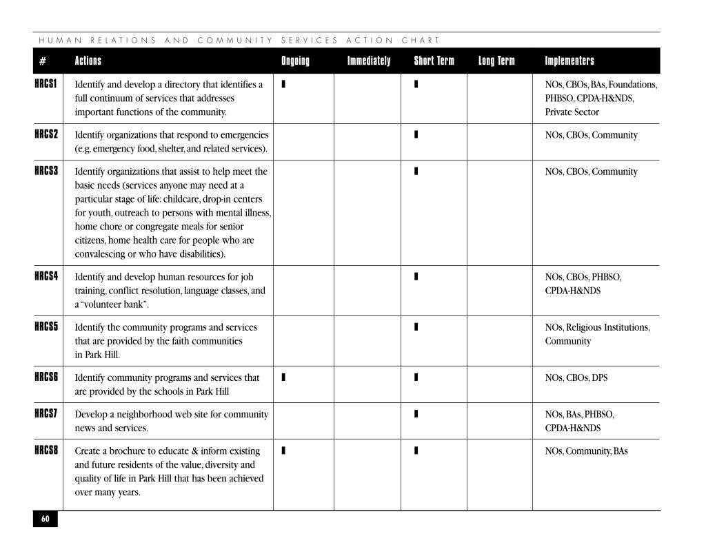
H U M A N R E L A T I O N S A N D C O M M U N I T Y S E R V I C E S A C T I O N C H A R T
60
# Actions Ongoing Immediately Short Term Long Term Implementers
HRCS1 Identify and develop a directory that identifies a ❚ ❚ NOs,CBOs,BAs,Foundations,full continuum of services that addresses PHBSO, CPDA-H&NDS,important functions of the community. Private Sector
HRCS2 Identify organizations that respond to emergencies ❚ NOs, CBOs, Community(e.g. emergency food, shelter, and related services).
HRCS3 Identify organizations that assist to help meet the ❚ NOs, CBOs, Communitybasic needs (services anyone may need at aparticular stage of life: childcare, drop-in centersfor youth, outreach to persons with mental illness,home chore or congregate meals for senior citizens, home health care for people who are convalescing or who have disabilities).
HRCS4 Identify and develop human resources for job ❚ NOs, CBOs, PHBSO,training, conflict resolution, language classes, and CPDA-H&NDS a “volunteer bank”.
HRCS5 Identify the community programs and services ❚ NOs, Religious Institutions,that are provided by the faith communities Communityin Park Hill.
HRCS6 Identify community programs and services that ❚ ❚ NOs, CBOs, DPSare provided by the schools in Park Hill
HRCS7 Develop a neighborhood web site for community ❚ NOs, BAs, PHBSO,news and services. CPDA-H&NDS
HRCS8 Create a brochure to educate & inform existing ❚ ❚ NOs,Community,BAsand future residents of the value, diversity and quality of life in Park Hill that has been achieved over many years.
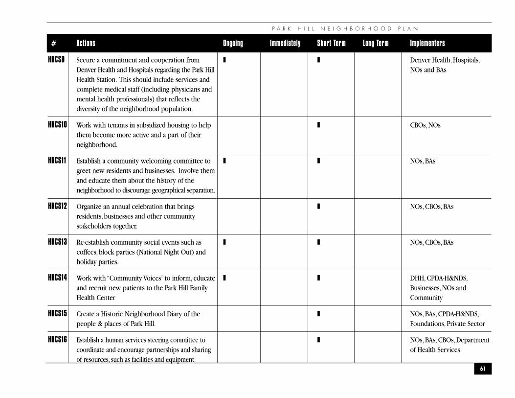
P A R K H I L L N E I G H B O R H O O D P L A N
61
# Actions Ongoing Immediately Short Term Long Term Implementers
HRCS9 Secure a commitment and cooperation from ❚ ❚ Denver Health, Hospitals,Denver Health and Hospitals regarding the Park Hill NOs and BAsHealth Station. This should include services and complete medical staff (including physicians and mental health professionals) that reflects the diversity of the neighborhood population.
HRCS10 Work with tenants in subsidized housing to help ❚ CBOs, NOsthem become more active and a part of their neighborhood.
HRCS11 Establish a community welcoming committee to ❚ ❚ NOs, BAsgreet new residents and businesses. Involve them and educate them about the history of the neighborhood to discourage geographical separation.
HRCS12 Organize an annual celebration that brings ❚ NOs, CBOs, BAsresidents, businesses and other community stakeholders together.
HRCS13 Re-establish community social events such as ❚ ❚ NOs, CBOs, BAscoffees, block parties (National Night Out) and holiday parties.
HRCS14 Work with “Community Voices” to inform, educate ❚ ❚ DHH, CPDA-H&NDS,and recruit new patients to the Park Hill Family Businesses, NOs andHealth Center Community
HRCS15 Create a Historic Neighborhood Diary of the ❚ NOs, BAs, CPDA-H&NDS,people & places of Park Hill. Foundations, Private Sector
HRCS16 Establish a human services steering committee to ❚ NOs, BAs, CBOs, Departmentcoordinate and encourage partnerships and sharing of Health Servicesof resources, such as facilities and equipment.
E D U C A T I O N
62
�E D U C A T I O N�
“If there is no struggle, there is no progress”
— Frederick Douglass
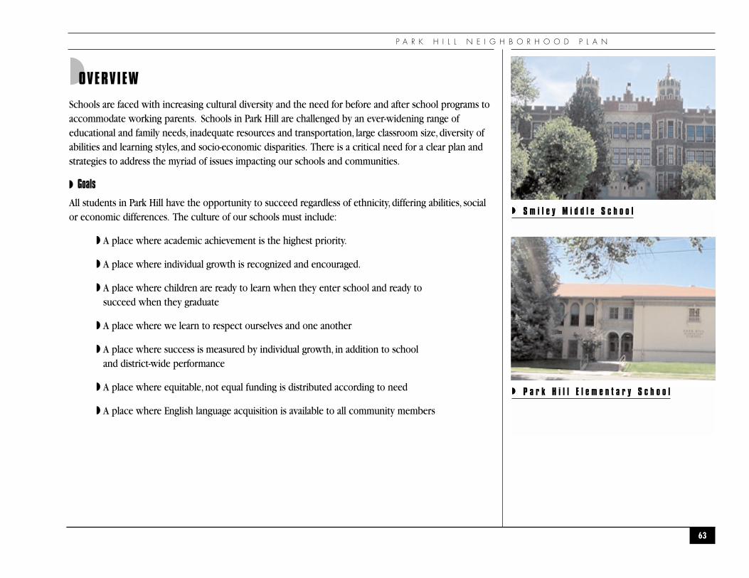
P A R K H I L L N E I G H B O R H O O D P L A N
◗OVERVIEW
Schools are faced with increasing cultural diversity and the need for before and after school programs toaccommodate working parents. Schools in Park Hill are challenged by an ever-widening range ofeducational and family needs, inadequate resources and transportation, large classroom size, diversity ofabilities and learning styles, and socio-economic disparities. There is a critical need for a clear plan andstrategies to address the myriad of issues impacting our schools and communities.
◗ Goals
All students in Park Hill have the opportunity to succeed regardless of ethnicity, differing abilities, socialor economic differences. The culture of our schools must include:
◗ A place where academic achievement is the highest priority.
◗ A place where individual growth is recognized and encouraged.
◗ A place where children are ready to learn when they enter school and ready to succeed when they graduate
◗ A place where we learn to respect ourselves and one another
◗ A place where success is measured by individual growth, in addition to school and district-wide performance
◗ A place where equitable, not equal funding is distributed according to need
◗ A place where English language acquisition is available to all community members
63
◗ S m i l e y M i d d l e S c h o o l
◗ P a r k H i l l E l e m e n t a r y S c h o o l
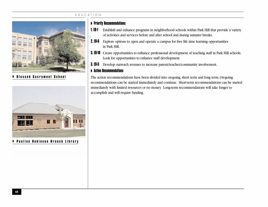
E D U C A T I O N
◗ Priority Recommendations:
1. ED-1 Establish and enhance programs in neighborhood schools within Park Hill that provide a varietyof activities and services before and after school and during summer breaks.
2. ED-6 Explore options to open and operate a campus for free life time learning opportunities in Park Hill.
3. ED-10 Create opportunities to enhance professional development of teaching staff in Park Hill schools.Look for opportunities to enhance staff development.
3. ED-5 Develop outreach avenues to increase parent/teacher/community involvement.
◗ Action Recommendations
The action recommendations have been divided into on-going, short term and long term. On-goingrecommendations can be started immediately and continue. Short-term recommendations can be startedimmediately with limited resources or no money. Long-term recommendations will take longer toaccomplish and will require funding.
64
◗ B l e s s e d S a c r a m e n t S c h o o l
◗ P a u l i n e R o b i n s o n B r a n c h L i b r a r y
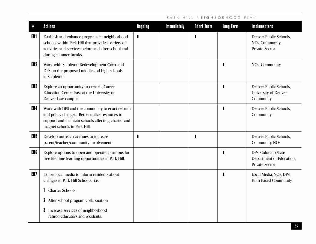
P A R K H I L L N E I G H B O R H O O D P L A N
65
# Actions Ongoing Immediately Short Term Long Term Implementers
ED1 Establish and enhance programs in neighborhood ❚ ❚ Denver Public Schools,schools within Park Hill that provide a variety of NOs,Community,activities and services before and after school and Private Sectorduring summer breaks.
ED2 Work with Stapleton Redevelopment Corp. and ❚ NOs, CommunityDPS on the proposed middle and high schools at Stapleton.
ED3 Explore an opportunity to create a Career ❚ Denver Public Schools,Education Center East at the University of University of Denver,Denver Law campus. Community
ED4 Work with DPS and the community to enact reforms ❚ Denver Public Schools,and policy changes. Better utilize resources to Communitysupport and maintain schools affecting charter and magnet schools in Park Hill.
ED5 Develop outreach avenues to increase ❚ ❚ Denver Public Schools,parent/teacher/community involvement. Community, NOs
ED6 Explore options to open and operate a campus for ❚ DPS, Colorado Statefree life time learning opportunities in Park Hill. Department of Education,
Private Sector
ED7 Utilize local media to inform residents about ❚ Local Media, NOs, DPS,changes in Park Hill Schools. i.e. Faith Based Community
1 Charter Schools
2 After school program collaboration
3 Increase services of neighborhood retired educators and residents.
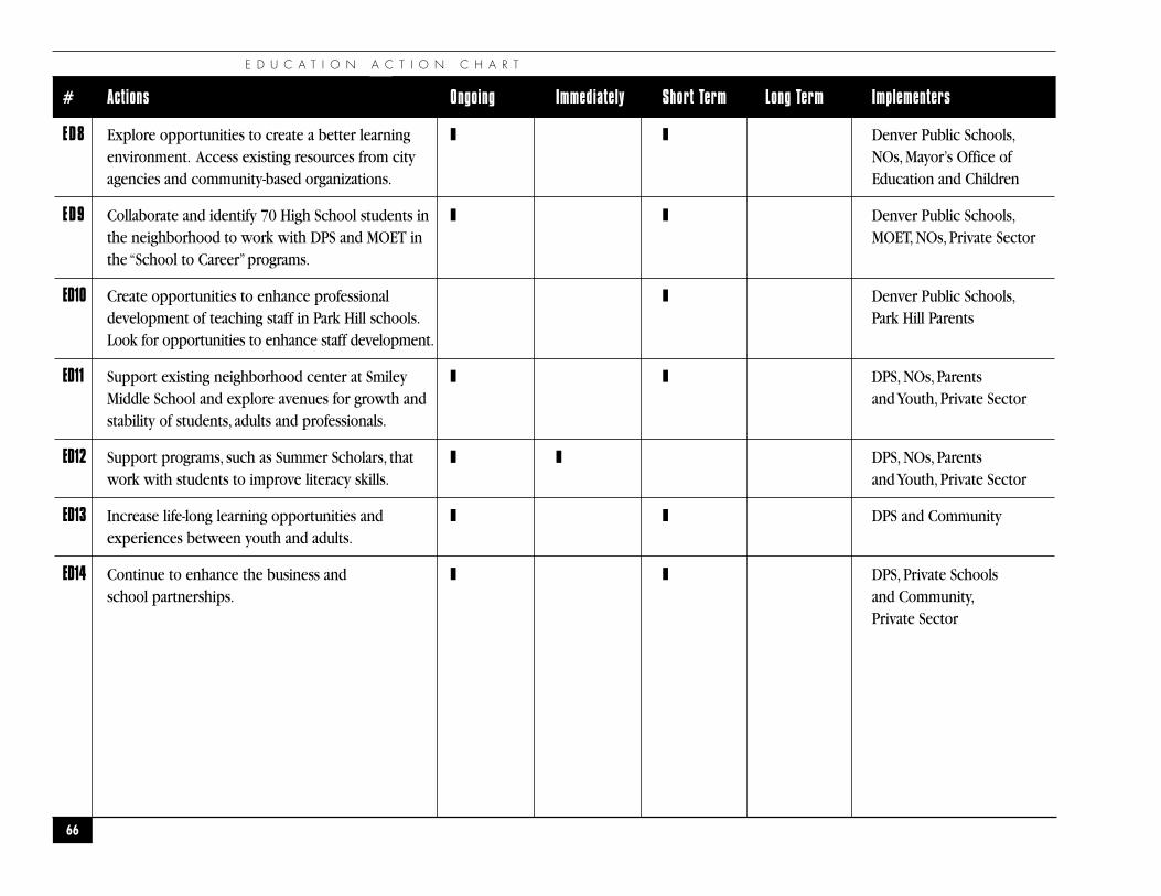
E D U C A T I O N A C T I O N C H A R T
66
# Actions Ongoing Immediately Short Term Long Term Implementers
ED8 Explore opportunities to create a better learning ❚ ❚ Denver Public Schools,environment. Access existing resources from city NOs, Mayor’s Office ofagencies and community-based organizations. Education and Children
ED9 Collaborate and identify 70 High School students in ❚ ❚ Denver Public Schools,the neighborhood to work with DPS and MOET in MOET, NOs, Private Sectorthe “School to Career”programs.
ED10 Create opportunities to enhance professional ❚ Denver Public Schools,development of teaching staff in Park Hill schools. Park Hill ParentsLook for opportunities to enhance staff development.
ED11 Support existing neighborhood center at Smiley ❚ ❚ DPS, NOs, ParentsMiddle School and explore avenues for growth and and Youth, Private Sectorstability of students, adults and professionals.
ED12 Support programs, such as Summer Scholars, that ❚ ❚ DPS, NOs, Parentswork with students to improve literacy skills. and Youth, Private Sector
ED13 Increase life-long learning opportunities and ❚ ❚ DPS and Communityexperiences between youth and adults.
ED14 Continue to enhance the business and ❚ ❚ DPS, Private Schoolsschool partnerships. and Community,
Private Sector
P A R K H I L L N E I G H B O R H O O D P L A N
67
�C O M M U N I T Y C O O R D I N A T I O N
�
“And so, my fellow Americans, ask not what your countrycan do for you; ask what you can do for your country. ”
— John F. Kennedy
Community Coordination, Communication, and Participation in DecisionMaking for Plan Implementation and Redevelopment Activities.
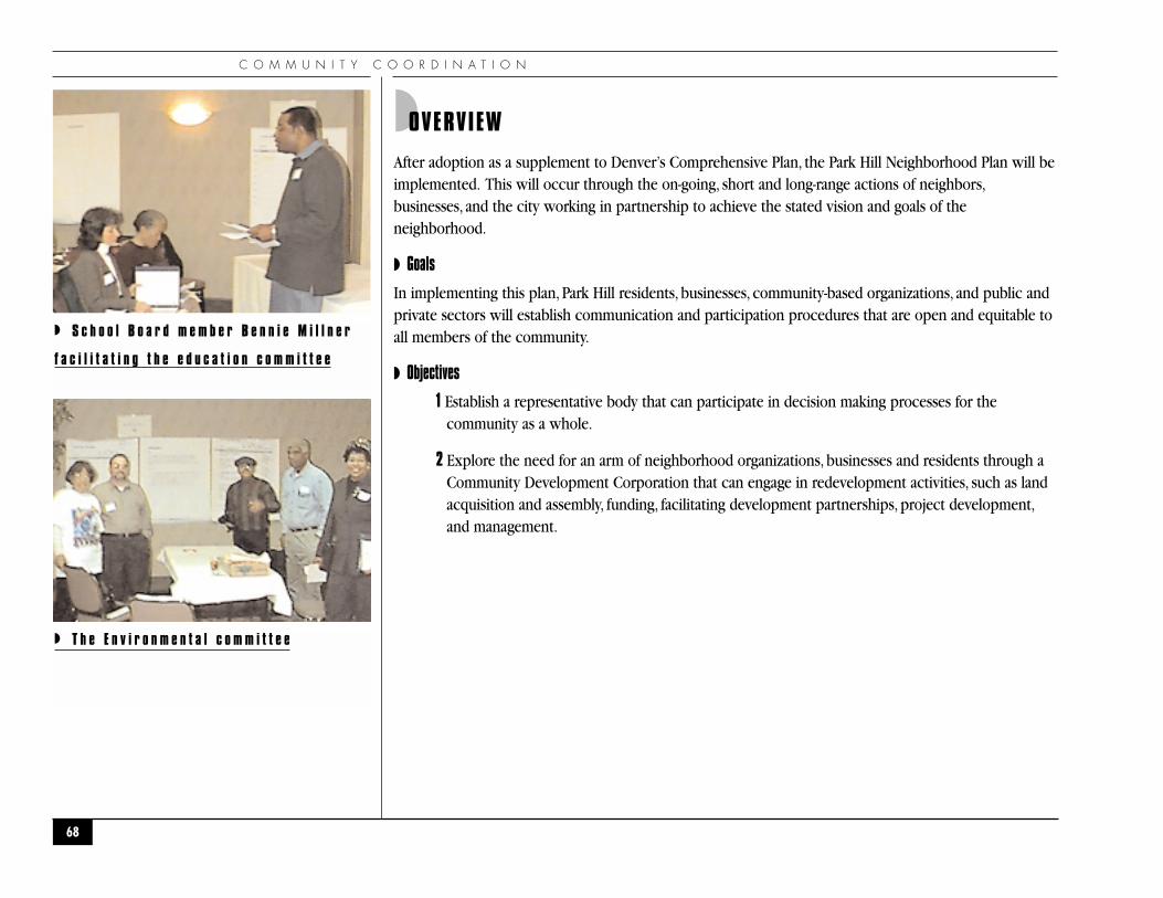
C O M M U N I T Y C O O R D I N A T I O N
◗OVERVIEW
After adoption as a supplement to Denver’s Comprehensive Plan, the Park Hill Neighborhood Plan will beimplemented. This will occur through the on-going, short and long-range actions of neighbors,businesses, and the city working in partnership to achieve the stated vision and goals of theneighborhood.
◗ Goals
In implementing this plan, Park Hill residents, businesses, community-based organizations, and public andprivate sectors will establish communication and participation procedures that are open and equitable toall members of the community.
◗ Objectives
1 Establish a representative body that can participate in decision making processes for thecommunity as a whole.
2 Explore the need for an arm of neighborhood organizations, businesses and residents through aCommunity Development Corporation that can engage in redevelopment activities, such as landacquisition and assembly, funding, facilitating development partnerships, project development,and management.
68
◗ S c h o o l B o a r d m e m b e r B e n n i e M i l l n e r
f a c i l i t a t i n g t h e e d u c a t i o n c o m m i t t e e
◗ T h e E n v i r o n m e n t a l c o m m i t t e e
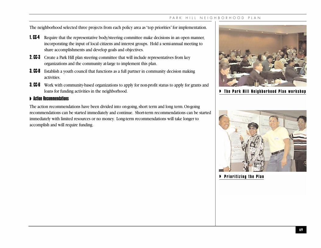
P A R K H I L L N E I G H B O R H O O D P L A N
The neighborhood selected three projects from each policy area as “top priorities” for implementation.
1. CC-4 Require that the representative body/steering committee make decisions in an open manner,incorporating the input of local citizens and interest groups. Hold a semi-annual meeting toshare accomplishments and develop goals and objectives.
2. CC-3 Create a Park Hill plan steering committee that will include representatives from keyorganizations and the community at-large to implement this plan.
3. CC-8 Establish a youth council that functions as a full partner in community decision makingactivities.
3. CC-6 Work with community-based organizations to apply for non-profit status to apply for grants andloans for funding activities in the neighborhood.
◗ Action Recommendations
The action recommendations have been divided into on-going, short term and long term. On-goingrecommendations can be started immediately and continue. Short-term recommendations can be startedimmediately with limited resources or no money. Long-term recommendations will take longer toaccomplish and will require funding.
69
◗ T h e P a r k H i l l N e i g h b o r h o o d P l a n w o r k s h o p
◗ P r i o r i t i z i n g t h e P l a n
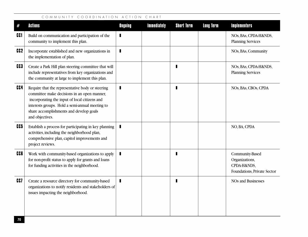
C O M M U N I T Y C O O R D I N A T I O N A C T I O N C H A R T
70
# Actions Ongoing Immediately Short Term Long Term Implementers
CC1 Build on communication and participation of the ❚ NOs, BAs, CPDA-H&NDS,community to implement this plan. Planning Services
CC2 Incorporate established and new organizations in ❚ NOs, BAs, Communitythe implementation of plan.
CC3 Create a Park Hill plan steering committee that will ❚ NOs, BAs, CPDA-H&NDS,include representatives from key organizations and Planning Servicesthe community at large to implement this plan.
CC4 Require that the representative body or steering ❚ ❚ NOs, BAs, CBOs, CPDAcommittee make decisions in an open manner,incorporating the input of local citizens and
interests groups. Hold a semi-annual meeting to share accomplishments and develop goals and objectives.
CC5 Establish a process for participating in key planning ❚ NO, BA, CPDAactivities, including the neighborhood plan,comprehensive plan, capitol improvements and project reviews.
CC6 Work with community-based organizations to apply ❚ ❚ Community-Basedfor non-profit status to apply for grants and loans Organizations,for funding activities in the neighborhood. CPDA-H&NDS,
Foundations, Private Sector
CC7 Create a resource directory for community-based ❚ ❚ NOs and Businessesorganizations to notify residents and stakeholders ofissues impacting the neighborhood.
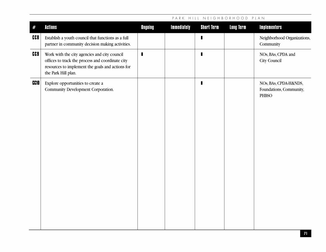
P A R K H I L L N E I G H B O R H O O D P L A N
71
# Actions Ongoing Immediately Short Term Long Term Implementers
CC8 Establish a youth council that functions as a full ❚ Neighborhood Organizations,partner in community decision making activities. Community
CC9 Work with the city agencies and city council ❚ ❚ NOs, BAs, CPDA andoffices to track the process and coordinate city City Councilresources to implement the goals and actions forthe Park Hill plan.
CC10 Explore opportunities to create a ❚ NOs, BAs, CPDA-H&NDS,Community Development Corporation. Foundations, Community,
PHBSO
D A H L I A A N D H O L L Y S H O P P I N G C E N T E R R E D E V E L O P M E N T
72
�D A H L I A A N D H O L L YS H O P P I N G C E N T E RR E D E V E L O P M E N T
�
Addendum for Commercial Development at the Dahlia and Holly Shopping Center Redevelopment
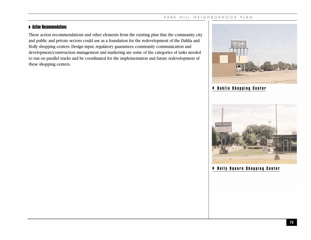
P A R K H I L L N E I G H B O R H O O D P L A N
◗ Action Recommendations
These action recommendations and other elements from the existing plan that the community, cityand public and private sectors could use as a foundation for the redevelopment of the Dahlia andHolly shopping centers. Design input, regulatory guarantees, community communication anddevelopment/construction management and marketing are some of the categories of tasks neededto run on parallel tracks and be coordinated for the implementation and future redevelopment ofthese shopping centers.
73
◗ D a h l i a S h o p p i n g C e n t e r
◗ H o l l y S q u a r e S h o p p i n g C e n t e r
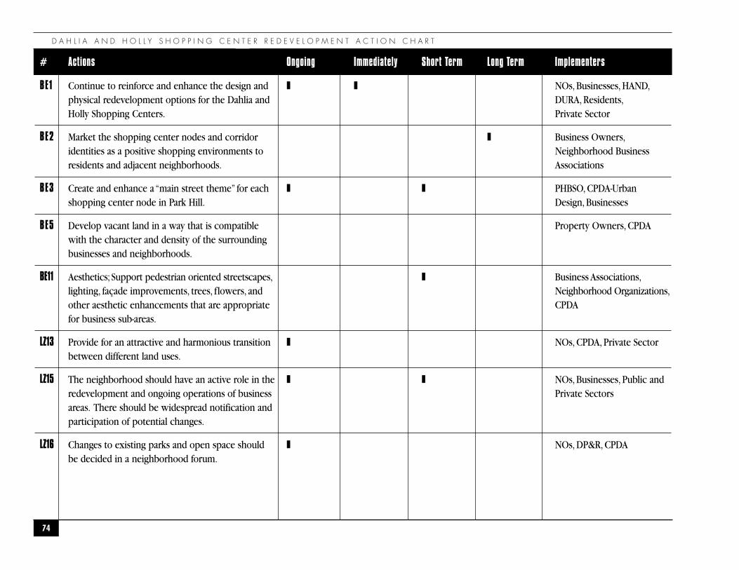
D A H L I A A N D H O L L Y S H O P P I N G C E N T E R R E D E V E L O P M E N T A C T I O N C H A R T
74
# Actions Ongoing Immediately Short Term Long Term Implementers
BE1 Continue to reinforce and enhance the design and ❚ ❚ NOs, Businesses, HAND,physical redevelopment options for the Dahlia and DURA, Residents,Holly Shopping Centers. Private Sector
BE2 Market the shopping center nodes and corridor ❚ Business Owners,identities as a positive shopping environments to Neighborhood Business residents and adjacent neighborhoods. Associations
BE3 Create and enhance a “main street theme” for each ❚ ❚ PHBSO, CPDA-Urbanshopping center node in Park Hill. Design, Businesses
BE5 Develop vacant land in a way that is compatible Property Owners, CPDAwith the character and density of the surrounding businesses and neighborhoods.
BE11 Aesthetics; Support pedestrian oriented streetscapes, ❚ Business Associations,lighting, façade improvements, trees, flowers, and Neighborhood Organizations,other aesthetic enhancements that are appropriate CPDAfor business sub-areas.
LZ13 Provide for an attractive and harmonious transition ❚ NOs, CPDA, Private Sectorbetween different land uses.
LZ15 The neighborhood should have an active role in the ❚ ❚ NOs, Businesses, Public and redevelopment and ongoing operations of business Private Sectorsareas. There should be widespread notification and participation of potential changes.
LZ16 Changes to existing parks and open space should ❚ NOs, DP&R, CPDAbe decided in a neighborhood forum.
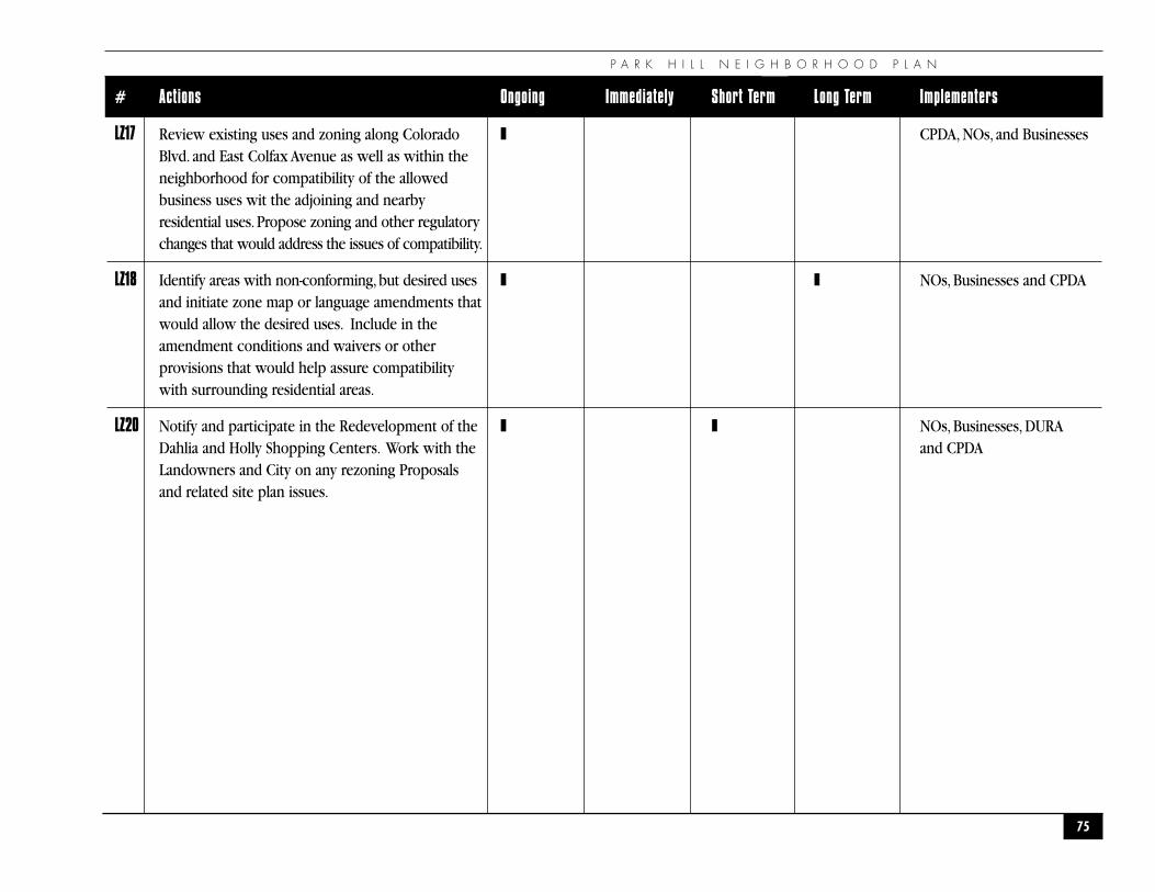
P A R K H I L L N E I G H B O R H O O D P L A N
75
# Actions Ongoing Immediately Short Term Long Term Implementers
LZ17 Review existing uses and zoning along Colorado ❚ CPDA, NOs, and BusinessesBlvd. and East Colfax Avenue as well as within the neighborhood for compatibility of the allowed business uses wit the adjoining and nearby residential uses.Propose zoning and other regulatory changes that would address the issues of compatibility.
LZ18 Identify areas with non-conforming,but desired uses ❚ ❚ NOs, Businesses and CPDAand initiate zone map or language amendments that would allow the desired uses. Include in the amendment conditions and waivers or other provisions that would help assure compatibility with surrounding residential areas.
LZ20 Notify and participate in the Redevelopment of the ❚ ❚ NOs, Businesses, DURA Dahlia and Holly Shopping Centers. Work with the and CPDALandowners and City on any rezoning Proposals and related site plan issues.
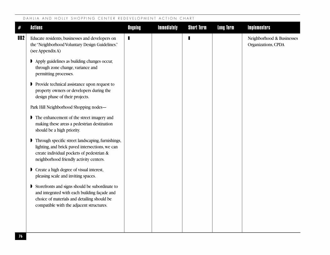
D A H L I A A N D H O L L Y S H O P P I N G C E N T E R R E D E V E L O P M E N T A C T I O N C H A R T
76
# Actions Ongoing Immediately Short Term Long Term Implementers
UD2 Educate residents, businesses and developers on ❚ ❚ Neighborhood & Businessesthe “Neighborhood Voluntary Design Guidelines.” Organizations, CPDA(see Appendix A)
◗ Apply guidelines as building changes occur,through zone change, variance and permitting processes.
◗ Provide technical assistance upon request to property owners or developers during the design phase of their projects.
Park Hill Neighborhood Shopping nodes—
◗ The enhancement of the street imagery and making these areas a pedestrian destination should be a high priority.
◗ Through specific street landscaping, furnishings,lighting, and brick paved intersections, we can create individual pockets of pedestrian & neighborhood friendly activity centers.
◗ Create a high degree of visual interest,pleasing scale and inviting spaces.
◗ Storefronts and signs should be subordinate to and integrated with each building façade and choice of materials and detailing should be compatible with the adjacent structures.
P A R K H I L L N E I G H B O R H O O D P L A N
77
# Actions Ongoing Immediately Short Term Long Term Implementers
UD5 Create and reinforce buffers along the ❚ CPDA, PW, Traffic andand reinforce buffers along the Transportation Divisionneighborhood borders and between residential to commercial and industrial areas.
UD6 Encourage landscaped buffers of parking areas ❚ CPDA, PW, Traffic andwithin the neighborhood. Transportation Division
D A H L I A A N D H O L L Y S H O P P I N G C E N T E R R E D E V E L O P M E N T
◗ Neighborhood Commercial Nodes
◗ New buildings or redevelopment projects in the commercial nodes shall include ground level street oriented retail and service space.
◗ Parking in retail nodes should be located at the rear and/or to one side of the building (away from the street). This will minimize gaps in the continuous building wall of the block.
◗ Use durable materials that complement Denver’s tradition as a brick and masonry city; limitbuilding façade materials to masonry, brick, brick veneer, stone, or stucco. Synthetic materials,which imitate natural or traditional materials, should be avoided.
◗ Public plazas should include trees, grass, flower beds, walkways, benches,and other pedestrian amenities,
◗ Create street level interest by requiring active ground floor uses with store windows facing plaza or street.
◗ Tree plantings and solid screening fences should separate business-zoned areas from residential.
◗ Develop special street signage to emphasize neighborhood plazas.
◗ Incorporate signage that is convenient and usable by motorists and pedestrians and iscomplementary to the character of the corridor and individual building architecture.
◗ Commercial Development
◗ Site and building design shall: reinforce traditional street oriented development patterns,setbacks, and build-to lines, provide a consistent edge to the public street and sidewalk space inorder to provide pedestrian scale and to encourage pedestrian-oriented activity;
◗ Provide visual interest and human scale through the use of prominent windows and operableentries at the street facing facades, varied forms, materials, detail, and color;
◗ Provide convenient pedestrian access from the public right-of-way to the project and utilizepedestrian-friendly site and building design;
78
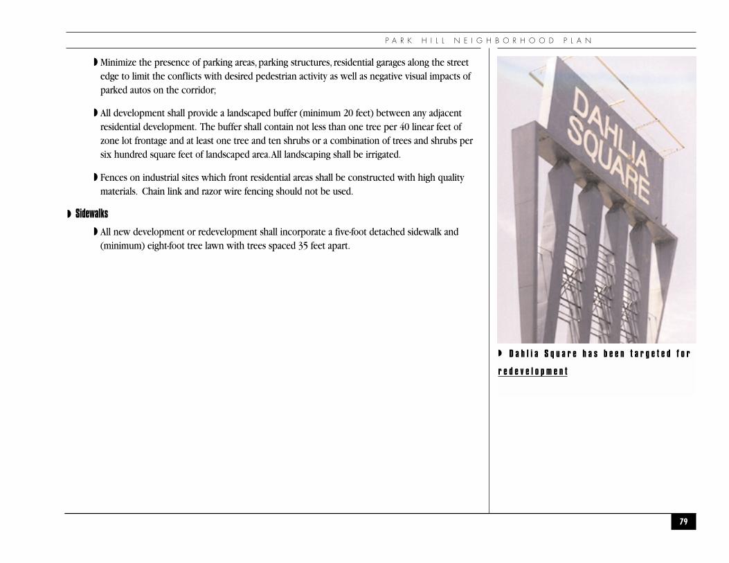
P A R K H I L L N E I G H B O R H O O D P L A N
◗ Minimize the presence of parking areas, parking structures, residential garages along the streetedge to limit the conflicts with desired pedestrian activity as well as negative visual impacts ofparked autos on the corridor;
◗ All development shall provide a landscaped buffer (minimum 20 feet) between any adjacentresidential development. The buffer shall contain not less than one tree per 40 linear feet ofzone lot frontage and at least one tree and ten shrubs or a combination of trees and shrubs persix hundred square feet of landscaped area.All landscaping shall be irrigated.
◗ Fences on industrial sites which front residential areas shall be constructed with high qualitymaterials. Chain link and razor wire fencing should not be used.
◗ Sidewalks
◗ All new development or redevelopment shall incorporate a five-foot detached sidewalk and(minimum) eight-foot tree lawn with trees spaced 35 feet apart.
79
◗ D a h l i a S q u a r e h a s b e e n t a r g e t e d f o r
r e d e v e l o p m e n t
A P P E N D I C E S
86
�A P P E N D I C E S�
P A R K H I L L N E I G H B O R H O O D P L A N
◗APPENDIX A
◗ Park Hill Urban Design Guidelines
These guidelines are provided as recommendations to property owners to serve as a tool in maintainingand enhancing the existing neighborhood character. They are not proposed as an overlay district, nor asa covenant, nor to replace existing zoning laws.
◗ Residential Areas
◗ Where alleys exist, all garage access should be limited to alley access. To preserve the“pedestrian friendliness”of the neighborhood the blocks should not be cut up with vehiculardriveways. Garage access shall be from the rear of the site where alleys are present.
◗ Were alleys do not exist, front loaded garages should be recessed a minimum of five feet from thefront facade of the buildings and shall not be more than 55% of the length of the front facade
◗ New construction should respect the Denver tradition of masonry construction. A minimum of75% of the street facing facade shall be constructed with brick. The brick facade should wraparound the side elevations for a minimum of 12 feet for mid- block residential units and for theentire length of the side street facade on a corner lot. New construction should utilize alleys.
◗ Neighborhood Commercial Nodes
◗ New buildings or redevelopment projects in the commercial nodes must include ground levelstreet oriented retail and service space.
◗ Parking in retail nodes should be located at the rear and/or to one side of the building (awayfrom the street). This will minimize gaps in the continuous building wall of the block.
◗ Use durable materials that complement Denver’s tradition as a brick and masonry city; limit thebuilding façade materials to masonry, brick, brick veneer, stone, or stucco. Synthetic materialswhich imitate natural or traditional materials should be avoided.
◗ Public plazas must include trees, grass, flower beds, walkways, benches, and other pedestrianamenities that the Denver Streetscapes manual supports.
87
A P P E N D I C E S
◗ Create street level interest by requiring active ground floor uses with store windowsfacing plaza or street.
◗ Tree plantings and solid screening fences should separate business zoned areas from residential.
◗ Develop special street signage to emphasis neighborhood plazas.
◗ Incorporate signage that is convenient and usable by motorist and pedestrians and iscomplementary to the character of the corridor and individual building architecture.
◗ Colfax Commercial Development
Site and building design shall:
◗ reinforce traditional street oriented development patterns, setbacks, and build-to lines, provide aconsistent edge to the public street and sidewalk space in order to provide pedestrian scale andto encourage pedestrian-oriented activity;
◗ provide visual interest and human scale through the use of prominent windows and operableentries at the street facing facades, varied forms, materials, detail, and color;
◗ provide convenient pedestrian access from the public right-of-way to the project and shall utilizepedestrian-friendly site and building design;
◗ minimize the presence of parking areas, parking structures, residential garages along the streetedge to limit the conflicts with desired pedestrian activity as well as negative visual impacts ofparked autos on the corridor;
88
P A R K H I L L N E I G H B O R H O O D P L A N
◗ Industrial Areas
◗ All industrial development shall provide a landscaped buffer (minimum 20 feet) between anyadjacent residential development. The buffer shall contain not less than one tree per 35 linearfeet of zone lot frontage and at least one tree and ten shrubs or a combination of trees andshrubs per six hundred square feet of landscaped area. If the buffer is on the backside it mustinclude a row of closely spaced evergreens. All landscaping shall be irrigated.
◗ Fences on industrial sites which front residential areas shall be constructed with high qualitymaterials (see illustration) Chain link and razor wire fencing should not be used.
◗ Sidewalks
◗ All new development or redevelopment shall incorporate a five-foot detached sidewalk and(minimum) eight-foot treelawn with trees spaced 35 feet apart.
89
A P P E N D I C E S
90
◗ZONE DISTRICTS – GENERAL DESCRIPTIONS
Residential and Institutional Zone Districts
R-S-2 Single-Unit Detached Dwellings, Rural Density: Minimum of one acre of land required for eachdwelling unit. Home occupations are prohibited. Density - 1 dwelling unit/acre.
R-S-4 Single-Unit Detached Dwellings, Suburban Density: Minimum of 12,000 square feet of landrequired for each dwelling unit. Home occupations are prohibited. Density = 3.6 dwellingunits/acre.
R-X Attached or Clustered Single-Unit Dwellings, Low Density: Development plan must be approvedby City Council. Home occupations are prohibited. Minimum of 7,500 square feet of land arearequired for each dwelling unit. Density = 5.8 dwelling units/acre.
R-0 Single-Unit Detached Dwellings, Low Density: Foster family care and day care allowed as homeoccupations by permit. Minimum of 6,000 square feet of land required for each dwelling unit.Density = 7.3 dwelling units/acre.
R-1 Single-Unit Detached Dwellings, Low Density: Same as R-0 except that other additional homeoccupations and room-renting to one or two persons are allowed upon application and issuanceof a permit. Density = 7.3 dwelling units/acre.
R-2 Multi-Unit Dwellings, Low Density:Typically duplexes and triplexes. Home occupations areallowed by permit. Minimum of 6,000 square feet of land required for each duplex structure withan additional 3,000 square feet required for every unit over 2. Density = 14.5 dwelling units/acre.
R-2-A Multi-Unit Dwellings, Medium Density: 2,000 square feet of land required for each dwellingunit unless site plan is submitted under the Planned Building Group (PBG) provisions, inwhich case 1,500 square feet of land is required for each unit. Home occupations are allowedby permit. Density = 21.8 dwelling units/acre (29 unit/acre under PBG, depending on open-space requirements).
P A R K H I L L N E I G H B O R H O O D P L A N
R-3-X Multi-Unit Dwellings,Medium Density:This is a medium density district intended to encourage newresidential development.Building size is controlled by bulk standards and open space requirements.Building floor area cannot exceed 2 times the site area.Maximum lot coverage is 40%.
R-3 Multi-Unit Dwellings, High Density: Building size is controlled by bulk standards, off-streetparking and open space requirements. Building floor area cannot exceed 3 times the site area.Maximum density is determined by the size of the units and the factors mentioned above.
R-4 Multi-Unit Dwellings and/or Offices, High Density:The purpose of this district is to provide alocation for high density residential and intensive office development. Building size is controlledby bulk standards, off-street parking and open space requirements.Allows hotel or motel usesand limited accessory retail shopping. Building floor area cannot exceed 4 times the site area.
R-4-X High Density Office, Multiple Unit with Special Review Zone District:This district allows mostof the same uses as the R-4 zone district; however, parking lots, nursing homes andneighborhood service uses are conditional uses.The basic maximum floor area to lot arearatio is 4:1 and may reach 5:1 by meeting specific criteria. Undeveloped floor area may betransferred under special circumstances.
R-5 Institutional District:Allows colleges, schools, churches and other institutional uses. Maximum lotcoverage is 60% of the zone lot. Building height is controlled by bulk standards.
Business Zone Districts
B-1 Limited Office District:This district provides office space for services related to dental andmedical care and for office-type services, often for residents of nearby residential areas.Thedistrict is characterized by a low-volume of direct daily customer contact.This district ischaracteristically small in size and is situated near major hospitals or between large businessareas and residential areas.The district regulations establish standards comparable to those ofthe low density residential districts, resulting in similar building bulk and retaining the lowconcentration of pedestrian and vehicular traffic. Building height is controlled by bulk standardsand open space requirements. Building floor area cannot exceed the site area.
91
A P P E N D I C E S
B-A-1 Arterial Office and Multi-Unit Dwellings District:Allows banks, offices, clinics, institutions,churches, multi-unit residences and office service uses. Requires 100 feet of arterial streetfrontage. Maximum lot coverage is 30%. Building floor area cannot exceed 2 times the site area.Building height is controlled by bulk standards. Maximum residential density is determined bythe size of the units and the factors mentioned above.Arterial setback areas are required forlandscaping.
B-2 Neighborhood Business District:This district provides for the retailing of commodities classed as“convenience goods,”and the furnishing of certain personal services, to satisfy the daily andweekly household or personal needs of the residents of surrounding residential neighborhoods.This district is located on collector streets, characteristically is small in size, usually is entirelysurrounded by residential districts and is located at a convenient walking distance from theresidential districts it is designed to serve.The district regulations establish standards comparableto those of low density residential districts, resulting in similar standards. Building floor areacannot exceed the site area.
B-A-2 Arterial Service District:This district is intended as a tourist oriented area, allowing restaurantsand hotels or motels with accessory automobile service stations. Requires 100 feet of arterialstreet frontage. Zone lot coverage not to exceed 30%. Building height is controlled by bulkstandards. Front setback areas are required for landscaping.
B-3 Shopping Center District:This district is primarily to provide the retailing of most commoditiesand the furnishing of certain personal services, satisfying all household and personal needs of theresidents of surrounding residential communities.This district is normally located on majorarterial or collector streets at or near the intersection with another major arterial or collectorstreet so that is has good vehicular accessibility.This district is characteristically large, usually isentirely surrounded by residential districts, and is located a convenient driving distance from theresidential districts it is designed to serve.The district regulations establish standards comparableto those of low density residential districts, resulting in similar building bulk on smaller parcelsand retaining a low concentration of vehicular traffic. Building height is controlled by bulkstandards and open space requirements. Building floor area cannot exceed the site area.
92
P A R K H I L L N E I G H B O R H O O D P L A N
B-A-3 Arterial General Business District:This district is designed to accommodate uses that areoriented toward the motorist and residents of nearby neighborhoods. Included among such usesare bowling alleys, theaters, nightclubs, drive-in restaurants and service stations. Setback areas arerequired for landscaping. Ground coverage by buildings cannot exceed 30% of the site. Buildingheight is controlled by bulk standards.
B-4 General Business District:This district is intended to provide for and encourage appropriatecommercial uses adjacent to arterial streets, which are normally transit routes. Uses include awide variety of consumer and business services and retail establishments that serve otherbusiness activities, and local transit-dependent residents within the district as well as residentsthroughout the city.The regulations generally allow a moderate intensity of use andconcentration for the purpose of achieving compatibility between the wide variety of usespermitted in the district. Building height is not controlled by bulk standards unless there is aproperty line to property line abutment with a residential use. Building floor area cannot exceedtwice the site area.
B-A-4 Automobile Sales and Service District:This district provides an area designed particularly for thespecial needs and characteristics of auto, boat and recreational vehicle sales and serviceactivities.The city's Comprehensive Plan encourages the establishment of this district inconcentrated centers rather than in a linear arrangement along arterials. Ground coverage bystructures cannot exceed 60% of the site area. Building height is controlled by bulk standards.
B-5 Central Business District: Permits businesses, office and light-industrial uses along withresidential and educational uses. Maximum floor area cannot exceed 10 times the site area, plusfloor area premiums for the development of plazas, arcades and atriums. Off-street parking is notrequired. Building height is not controlled except for Federal Aviation Administration restrictions.Ground level retail uses are encouraged along the 16th Street Mall area.
B-7 Historic Business District:This district is intended to preserve and improve older structures that arearchitecturally and/or historically significant.Allows light-industry, general retail,wholesale,officesand residential uses.Building floor area cannot exceed 2 times the site area;however,withpremiums the floor area can be increased to 4 times the site area.Additional floor area is allowedwith the development of residential units,underground parking or retail uses at the street level.Refer to Ordinance #109 Series of 1988, regarding design guidelines and height limitations.
93
A P P E N D I C E S
B-8 Intensive General Business/High Density Residential District:This district, primarily for activitycenters, provides the concentration of retailing, personal and business services, as well asresidential and cultural uses at a necessary intensity to efficiently be served by mass transitfacilities.The regulations are designed to permit a highly concentrated, intense development ofthe enumerated facilities, limited by standards designed to provide light and air for streetexposures of buildings in the district. Building floor area cannot exceed 4 times the site area plusfloor area premiums for the development of plazas, arcades, or the provision of low-level lightareas. Building height is not controlled by bulk standards.
B-8-A Arapahoe Square Zone District:This is a mixed use zone district located in the Arapahoe Square(bounded by 20th Street, Larimer Street, Park Avenue West and Curtis Street) that encouragespedestrian activity areas and related uses while making auto related uses and other more intenseuses conditional uses subject to design review. Housing, the arts, child care facilities andpreservation of historic buildings are favored uses in this area and subject to generous floor areapremiums above the basic 4:1 F.A.R.
B-8-G Golden Triangle Zone District:This is a mixed use zone district located in the Golden Triangle(bounded by Speer Blvd., Lincoln Street, and Colfax Avenue) that encourages pedestrianactivity areas and related uses while making auto related uses and other more intense usesconditional uses subject to design review. Housing, the arts, child care facilities andpreservation of historic buildings are favored uses in this area and subject to generous floorarea premiums above the basic 4:1 F.A.R.
Industrial Zone Districts
I-0 Light Industrial/Office District:This district is intended to be an employment area containingoffices, and light industrial uses which are generally compatible with residential uses. I-0 zonedareas are designed to serve as a buffer between residential areas and more intensive industrialareas. Bulk plane, setback and landscaping standards apply in this district. Building floor areacannot exceed 50% of the site area; however, office floor area may equal site area. Some uses areconditional uses.
94

P A R K H I L L N E I G H B O R H O O D P L A N
I-1 General Industrial District:This district is intended to be an employment area containingindustrial uses which are generally more intensive than those permitted in the I-0 zone. Bulkplane, setback and landscape standards apply in this district. Building floor area cannot exceedtwice the site area. Some uses are conditional uses.
I-2 Heavy Industrial District:This district is intended to be an employment area containing useswhich are generally more intensive than that permitted in either of the other two industrialzones. Bulk plane, setback and landscape standards apply in this district. Building area cannotexceed twice the site area. Some uses are conditional uses.
Mixed-Use Zone Districts
C-MU-10 Commercial Mixed-Use District:The C-MU-10 district is the most restrictive of the commercialmixed-use districts, with the shortest list of allowed uses. It includes commercial usesappropriate for high-visibility locations such as employment centers and the intersections ofarterial streets.The purpose of the district is to concentrate higher intensity commercial uses,spatially define streets, encourage higher site standards, and create a more attractive pedestrianenvironment. Uses incompatible with this purpose, such as auto-related uses, industrial uses, andsingle unit dwellings, are not allowed.Although residential uses are permitted in the “C-MU”districts, it is expected that residential uses shall be responsible for buffering themselves fromnonresidential uses that may locate on adjacent property.
C-MU-20 Commercial Mixed-Use District:The C-MU-20 district provides for a mix of commercial, residential,and industrial uses along or near arterials or other high traffic streets. Site and building design willbe of a quality that enhances the character of the streets.A wide range of commercial andresidential uses are allowed, along with limited industrial uses.Although residential uses arepermitted in the “C-MU”districts, it is expected that residential uses shall be responsible forbuffering themselves from nonresidential uses that may locate on adjacent property.
C-MU-30 Commercial Mixed-Use District:The C-MU-30 district provides for a wide range of commercial,office, retail, industrial, and residential uses that allow property owners the flexibility to respondto the long-term evolution of development trends.Although residential uses are permitted in the“C-MU”districts, it is expected that residential uses shall be responsible for buffering themselvesfrom nonresidential uses that may locate on adjacent property.
95
A P P E N D I C E S
R-MU-20 Residential Mixed-Use District:The R-MU-20 district is primarily residential, allowing either singleor multiple-unit dwellings.Along heavily traveled streets, development may be either residentialor mixed-use, combining residential with neighborhood-serving retail, office, or service uses. Nomaximum residential density is prescribed; instead, the scale of buildings is determined by bulkplane, maximum height, setbacks, open space requirements, and parking ratios.The intent is toencourage a full range of housing types, including affordable housing.
R-MU-30 Residential Mixed-Use District:The R-MU-30 district is a primarily residential district allowinghigher density multiple unit dwellings of a density appropriate to the center-city and otheractivity centers such as light rail transit stations. Supporting commercial development, such asconsumer retail and service uses and small-scale office uses, is encouraged to create a trulymixed-use environment. No maximum residential density is prescribed. Instead, maximumheight, setbacks, and open space requirements determine the scale of buildings.
Open Space/Agricultural Zone District
O-1 Open Space District:Allows airports, recreational uses, parks, cemeteries, reservoirs, communitycorrectional facilities, and other public and semi-public uses housed in buildings. Setbackrequirements apply to the location of structures.
OS-1 Open Space District:The OS-1 district is intended for publicly and privately owned parks, openspace, natural habitats, golf courses, and a limited range of other uses, such as public recreationcenters and concessions, that may enhance the use and enjoyment of open space.
O-2 Open Space/Agricultural District:Allows large tracts of open land utilized for agriculture orranching activities, airports and under special conditions, oil and gas production.
Parking Zone District
P-1 Off-Street Parking District:Allows parking lots and structures. Bulk and setback regulations applyto structures.This zone is intended to provide needed business parking without the expansion ofthe business zone; e.g. a buffer between business and residential uses. Requires visual barriersadjacent to residential uses.
96
P A R K H I L L N E I G H B O R H O O D P L A N
Planned Unit Development
PUD Planned Unit Development: PUD is a form of development generally characterized by a unified sitedesign for clustering buildings and providing common open-space, density increases, and a mix ofbuilding types and land uses.The process involves site plan review, during which the city agencies andneighborhood residents have considerable input in determining the nature of the development. In effect,any PUD is a specific zone district for a specific area, including precise regulations written by theapplicant, and when approved by City Council, is enforced by the city. It allows maximum flexibilityduring the planning stage and maximum assurance that exactly what is proposed will be developed.
Platte River Valley Zone District
PRV Platte River Valley Zone District:This district is intended to promote and encourage diversifiedland uses and to integrate the district's unique geographic location and setting, amenities of view,transportation linkages and open space.A variety of land uses are permitted to facilitate newdevelopment, allow for the reuse of eligible historic structures and to complement development inadjacent neighborhoods and downtown. New residential development and open-space is encouraged.Regulatory flexibility is provided to facilitate development responsive to current and future marketconditions, and to encourage creativity in the development of the Platte River Valley. Subareaboundaries are delineated on the PRV zoning map.A subarea plan, including preliminary designguidelines, is required for all or part of the subarea to be used as a framework for private and publicdevelopment projects. Rules and criteria adopted by the Planning Board govern the content andrequirements of subarea plans. Plans for any given subarea must conform with the subarea zoningstandards enacted by City Council.
Cherry Creek North Zone District
CCN Cherry Creek North: Uses are similar to the B-3 district except that residential development is notpermitted on the ground floor of any building. Proposed developments are reviewed by the CCN DesignAdvisory Board (DAB) for compliance with the CCN district guidelines.The goals of the district are toencourage a mixture of uses and to encourage low-scale, small lot development that reinforces andenhances the eclectic urban character of the area. Floor area premiums are available for open space andunderground parking. Off-street parking requirements for retail uses is reduced and ground levelresidential development is not allowed.
97

A P P E N D I C E S
98
Hospitals Zone District
H-1-A, H-1-B, H-2 Hospital Zone Districts:The H-1-A and H-1-B districts are intended to promote andencourage the maintenance and concentration of existing and proposed healthcare facilities and theirrelated uses.The H-1-A and H-1-B districts are intended to contain the principal structures and relatedfacilities of each healthcare institution.The H-2 district is intended to contain the peripheral area of eachhealthcare facility where there is abutment or close proximity to non-healthcare uses.
The H-1-A district generally corresponds to the R-3 zone district as to permitted structures and to the R-4zone district as to permitted uses.The H-1-B district generally corresponds to the R-5 zone district forboth permitted uses and structures.The H-2 zone district generally corresponds to the R-5 zone districtfor both permitted uses and structures with additional landscaping and buffering required.
Gateway Airport Zone District
Gateway Airport Gateway Zone District:The airport gateway is intended to provide a wide variety ofcompatible uses.A mix of residential, business, hotel and high technology based industry is permitted.The streets design is a neo-traditional grid system. Development will be guided by development andspecial review.This is the first district to include environmental controls in the zoning ordinance.
Overlay Zone District
OD Overlay Zone District:These districts overlay existing standard zone districts.They are generallymore restrictive than the underlying zone and control dimensional and operational requirements of uses,but do not add uses to the underlying zone. Please refer to the zoning ordinance for the specificrequirements of each overlay zone.
S-T-Z Zone District
S-T-Z Stapleton Transitional Zone District:This district is a transitional zone limited to the old Stapleton Airport site. This zone district provides for the interim use of the Stapleton airport sitepreceding redevelopment.
P A R K H I L L N E I G H B O R H O O D P L A N
99
�A P P E N D I X C : A S S E S S M E N T�
A P P E N D I C E S
◗USE OF ASSESSMENT
This assessment provides background information to help residents in forming a more complete picture oftheir neighborhood and in choosing which issues to address.This baseline assessment has been preparedso that it can be easily refined and expanded once the new census information is available.
◗SUMMARY
◗ Where is the neighborhood located?
Census tracts 41.01, 41.02,41.03, 41.04, 42.01, 42.02 in Park Hill is bounded by City limits on the north,Quebec Street on the east, Colfax Avenue on the south and Colorado Boulevard on the west. Theneighborhood is located within the boundaries of City Council Districts 8 and 11.
◗ Population Characteristics
The population of the neighborhood grown steadily from 24,822 residents in 1990 to 26,645 residents in1998. In 1998, the percentage of children and youth was larger than the city average, and the percentageof resident’s age 18 or older was smaller than the city average.The age distribution of Park Hill in 1990was as follows: 8% were under of 5 years of age, 22% were between 5 to 18 years of age, 60% werebetween 19 to 64 years of age, and 10% were 65 and older. The neighborhood’s minority populationaccording to the 1990 U.S. Census Bureau, 60% of Park Hill’s population were Black, 34% were White, 4%were Hispanic and 2% were others.
◗ Education and Schools
Starting with the 1997-1998 school year, nearly all Denver Public Schools became “neighborhood schools.”Park Hill has several schools that serve residents in the neighborhood. Elementary Schools include HalletElementary located at 2950 Jasmine St., Park Hill Elementary, at 5050 E. 19th Avenue, Phillips Elementary, at6550 E. 21st Avenue, Smith Elementary, at 3590 Jasmine Street and Stedman Elementary at 2940 Dexter St.Smiley Middle School, at 2540 Holly St. Park of Park Hill students attend Gove Middle School, 4050 East14th Avenue. There is no Public High in the neighborhood.
100
P A R K H I L L N E I G H B O R H O O D P L A N
The majority of Park Hill students attend Manuel High School, at 1700 E.28th Avenue and East High Schoolat 1545 Detroit Street, and some attend George Washington High School at 655 South Monaco Street.
Park Hill has various private school institutions. Blessed Sacrament School located at 1973 Elm St., UnionBaptist Church Excel Institute located at 3200 Dahlia St.The Denver University Law School, Park HillCampus, located at 7039 E. 18th Avenue will be replaced by Johnson and Wales University and the newDenver Public High School for the Performing Arts. The percentage of high school graduates in theneighborhood (83%) was above the city average (79%) in 1990.
◗ Income Characteristics
In 1990, the neighborhood’s average household income ($43,303) compared favorably to the City ofDenver ($33,983). At that time, the percentage of the population living below the poverty threshold(15.5%) was less than the city average (17%). However, in Census Tracts 4101 and 4102 the percentage ofthe population living below the poverty threshold was 27.4% and children below the poverty thresholdwas 41.6%. The neighborhood’s unemployment rate of 9% was higher than the 1990 city average (7%).
◗ Land use and Zoning
The majority of the neighborhood consists of single-family residences zoned R-O and R-2. Commercialshopping centers exist at the 34th Avenue and Dahlia Street, 34th Street and Holly Street as well as at thenortheast corner of Colorado Boulevard and Smith Road. There are several other small neighborhoodserving retail centers.
◗ Property Maintenance and Zoning Violations
The Neighborhood Inspection Services Division has surveyed the neighborhood for zoning andproperty maintenance violations in October 1999. In particular, the following conditions were surveyedin the residential, commercial and industrial areas: vacant property, alleys, home and yard maintenance,roof conditions, graffiti vandalism, fence conditions, abandoned or inoperable vehicles, and illegalparking, illegal signs, unpaved surfaces, screening and buffering.
101
A P P E N D I C E S
◗ Housing characteristics
Park Hill has experienced a stable but slight increase in housing units over the last 30 years.Theneighborhood had 10,381 housing units in 1960, 10,387 in 1970, 10,480 in 1980, 10,556 in 1990, and anestimated 10,571 in 1998. The average sales price of a house in 1998 was $150,352 or $126 per squarefoot compared to 172,731 or $129 per square foot in Denver. The housing in Park Hill is very diversewith 70% built before 1940 in Census Tracts 42.01 and 42.02, 36% in Census Tracts 41.03 and 41.04 and2% in Census Tracts 41.01 and 41.02. Compared to 30% built before 1940 in Denver. In 1996, 6 housingunits were recorded boarded up. Thirty-three percent of the housing units in Park Hill are renteroccupied, less than the citywide rental average of 51%.
In terms of housing affordability, 40% of Park Hill residents pay over 35% of their income for rent vs. 32%of Denver renters and 19% of Park Hill homeowners pay under 35% of their income for their housingcompared to 16% of Denver homebuyers. In 1990, 61% of the residents lived in the same home for atleast 5 years compared to 46% in all of Denver.
◗ Streets and Traffic
The neighborhood and City will work to identify issues related to infrastructure and street maintenancein the neighborhood provided by Public Works--Street Transportation Division of the City and County ofDenver and other local governments entities.
◗ Water and Sewer
The city’s water and sanitary sewer systems serve all homes.
◗ Police Service
The neighborhood is served by Police District 2, located at 3555 Colorado Boulevard. Theneighborhood’s crime rate has decreased by 3% over the past three years. Calls for police service in theneighborhood were below the city average in 1997. At that time, the crime rate for domestic violencewas almost 50% above the city average while the crime rate for drug crimes was almost 43% below thecity average. Crime rates for robbery and gang related crimes were 29% and 36% below the city averages,respectively. All other crime rates were closer to the 1997 city averages. There are several block watchgroups actively working in the neighborhood.
102
P A R K H I L L N E I G H B O R H O O D P L A N
◗ Fire Service
The neighborhood is served by Fire Station #10 at 3200 Steele Street, #14 at 1426 Oneida Street and #26at 7045 East 38th. Fire response times in the neighborhood were lower than the city average in 1997. Atthat time, calls for fire and/or emergency medical service were above the city average.
◗ Parks, Recreation and Library
Park Hill has several neighborhood parks, Clayton Park, located at M.L. King Blvd. & Cherry St., FergusonPark, at 23rd Avenue and Dexter St., Martin Luther King Park at 38th Avenue and Newport St., Milan Park,at Martin Luther King and Quebec St., Fred Thomas Park, at 26th Avenue and Quebec St. and Denver CityPark is located West of Colorado Blvd. from 17th to 26th Avenues.There are several recreation centers andprograms that serve the residents of Park Hill, as well as, others who do not reside in this community.These include Martin Luther King Recreation Center located at 3880 Newport St., Skyland RecreationCenter at 3334 Holly St., Park Hill Golf Course and the City Park Golf Course. A variety of recreational andeducational programs is offered at these facilities. The neighborhood is served by the Park Hill BranchLibrary, located at 4705 Montview Boulevard and Dahlia Branch Library at 3380 Dahlia Street.
◗ Community Assets
The Park Hill Health Station, located at 3401 Elm Street. In addition, a broad range of services is availableto neighborhood residents through a variety of providers.
◗ Public Transportation
The Bus service in Park Hill is extensive with service available on most major in minor arterial streets,with Colfaxand Colorado Boulevard carrying more than 300 buses per day. There is proposal on the table for a commuterrail line that will connect the community from Union Station Downtown to Denver International Airport.
◗ Where is the Neighborhood Located?
The neighborhood is bounded by City limits on the north, Quebec Street on the east, Colfax Avenue onthe south and Colorado Boulevard on the west. The neighborhood is located within the boundaries ofCity Council Districts 8 and 11.
◗ Have there been any special or specific plans prepared for the neighborhood in the past?
There have not been any special or specific plans prepared for the neighborhood. The community ispresently preparing a neighborhood plan for Park Hill.
103
A P P E N D I C E S
104
�D E M O G R A P H I C S�
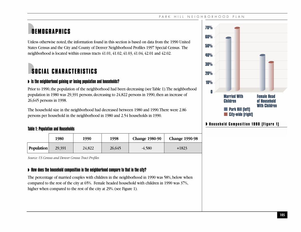
P A R K H I L L N E I G H B O R H O O D P L A N
105
◗ H o u s e h o l d C o m p o s i t i o n 1 9 9 0 ( F i g u r e 1 )
◗DEMOGRAPHICS
Unless otherwise noted, the information found in this section is based on data from the 1990 UnitedStates Census and the City and County of Denver Neighborhood Profiles 1997 Special Census. Theneighborhood is located within census tracts 41.01, 41.02, 41.03, 41.04, 42.01 and 42.02.
◗SOCIAL CHARACTERISTICS
◗ Is the neighborhood gaining or losing population and households?
Prior to 1990, the population of the neighborhood had been decreasing (see Table 1).The neighborhoodpopulation in 1980 was 29,391 persons, decreasing to 24,822 persons in 1990, then an increase of26,645 persons in 1998.
The household size in the neighborhood had decreased between 1980 and 1990.There were 2.86persons per household in the neighborhood in 1980 and 2.54 households in 1990.
Table 1: Population and Households
1980 1990 1998 Change 1980-90 Change 1990-98
Population 29,391 24,822 26,645 -4,580 +1823
Source: US Census and Denver Census Tract Profiles
◗ How does the household composition in the neighborhood compare to that in the city?
The percentage of married couples with children in the neighborhood in 1990 was 58%, below whencompared to the rest of the city at 65%. Female headed household with children in 1990 was 37%,higher when compared to the rest of the city at 29%. (see Figure 1).
10%
0
20%
30%
40%
50%
60%
70%
Married WithChildren
Female Headof HouseholdWith Children
Park Hill (left)City-wide (right)
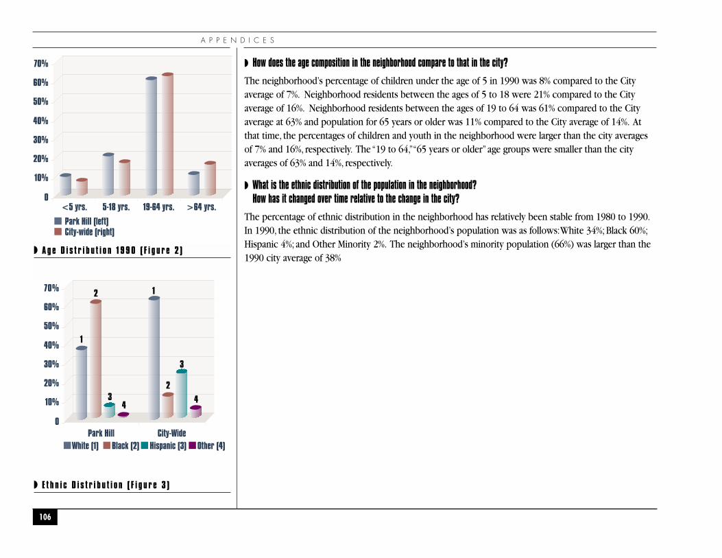
10%
0
20%
30%
40%
50%
60%
70%
Park Hill (left)
<5 yrs. 5-18 yrs. 19-64 yrs. >64 yrs.
City-wide (right)
A P P E N D I C E S
◗ How does the age composition in the neighborhood compare to that in the city?
The neighborhood’s percentage of children under the age of 5 in 1990 was 8% compared to the Cityaverage of 7%. Neighborhood residents between the ages of 5 to 18 were 21% compared to the Cityaverage of 16%. Neighborhood residents between the ages of 19 to 64 was 61% compared to the Cityaverage at 63% and population for 65 years or older was 11% compared to the City average of 14%. Atthat time, the percentages of children and youth in the neighborhood were larger than the city averagesof 7% and 16%, respectively. The “19 to 64,”“65 years or older”age groups were smaller than the cityaverages of 63% and 14%, respectively.
◗ What is the ethnic distribution of the population in the neighborhood? How has it changed over time relative to the change in the city?
The percentage of ethnic distribution in the neighborhood has relatively been stable from 1980 to 1990.In 1990, the ethnic distribution of the neighborhood’s population was as follows:White 34%; Black 60%;Hispanic 4%; and Other Minority 2%. The neighborhood’s minority population (66%) was larger than the1990 city average of 38%
106
◗ A g e D i s t r i b u t i o n 1 9 9 0 ( F i g u r e 2 )
10%
0
20%
30%
40%
50%
60%
70%
Park Hill City-WideWhite (1) Black (2) Hispanic (3) Other (4)
1
12
2
3
34
4
◗ E t h n i c D i s t r i b u t i o n ( F i g u r e 3 )
P A R K H I L L N E I G H B O R H O O D P L A N
107
�E D U C A T I O N A N DS C H O O L S
�
A P P E N D I C E S
◗ How do the neighborhood’s educational attainment rates compare to the city’s educational attainment rates?
The percentage of adult residents in the neighborhood with no diploma is 18%. High School graduate or+ is 82% and the percentage College Graduate or + is 31%. In comparison to the Citywide educationalattainment rate of 21% that have no diploma, 79% that have a High School Diploma or + and 29% that areCollege Graduate or +.
However, in Census tract 41.01--33% of the residents have no diploma that is higher than theneighborhood and citywide average. 67% are high school graduate or + that is below the neighborhoodand citywide average.
◗ Which elementary schools serve the neighborhood?
Starting with the 1997-1998 school year, nearly all Denver Public Schools became “neighborhoodschools.” Park Hill has several schools that serve residents and individuals outside to the community.Elementary Schools include Hallet Elementary located at 2950 Jasmine St., Park Hill Elementary, at 5050 E.19th Avenue, Phillips Elementary, at 6550 E. 21st Avenue, Smith Elementary, at 3590 Jasmine Street andStedman Elementary at 2940 Dexter St.There is one middle school, Smiley Middle School, at 2540 HollySt. Presently there is no Public High school serving Park Hill students.The majority of Park Hill studentsattend Manuel High School, at 1700 E.28th Avenue and East High School at 1545 Detroit Street, and someattend George Washington High School at 655 South Monaco Street.
Park Hill has various Private School Institutions that serve residents individuals outside of the community.Blessed Sacrament School located at 1973 Elm St., Union Baptist Church Excel Institute located at 3200Dahlia St., and Denver University Law School, Park Hill Campus, located at 7039 E. 18th Avenue.
◗ How do the test scores of these schools compare to state scores?
Students in the fourth and seventh grades were tested through the Colorado Statewide AssessmentProgram. The Results for 1997, 1998 and 1999 are reported in terms of the statewide percentile rankachieved in the subject areas of reading and writing (see Table 2).The corresponding school scores for1997 and 1998 are provided for comparison purposes.
108
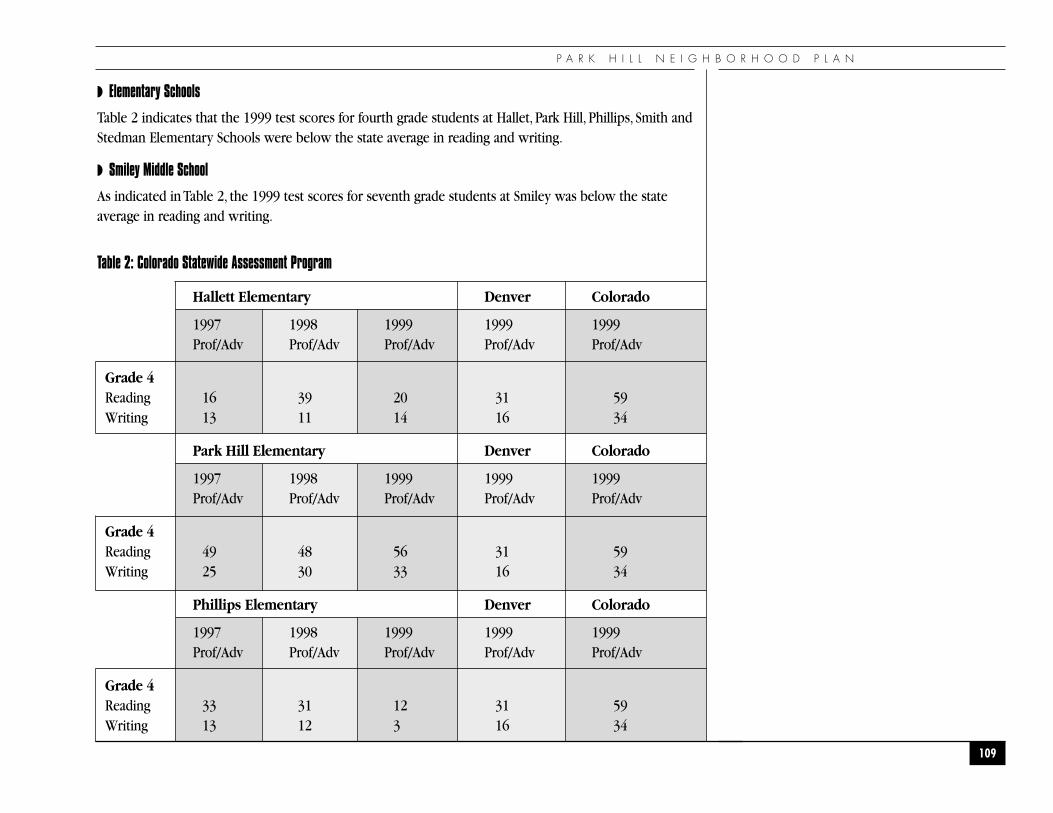
◗ Elementary Schools
Table 2 indicates that the 1999 test scores for fourth grade students at Hallet, Park Hill, Phillips, Smith andStedman Elementary Schools were below the state average in reading and writing.
◗ Smiley Middle School
As indicated in Table 2, the 1999 test scores for seventh grade students at Smiley was below the stateaverage in reading and writing.
Table 2: Colorado Statewide Assessment Program
Hallett Elementary Denver Colorado
1997 1998 1999 1999 1999Prof/Adv Prof/Adv Prof/Adv Prof/Adv Prof/Adv
Grade 4Reading 16 39 20 31 59Writing 13 11 14 16 34
Park Hill Elementary Denver Colorado
1997 1998 1999 1999 1999Prof/Adv Prof/Adv Prof/Adv Prof/Adv Prof/Adv
Grade 4Reading 49 48 56 31 59Writing 25 30 33 16 34
Phillips Elementary Denver Colorado
1997 1998 1999 1999 1999Prof/Adv Prof/Adv Prof/Adv Prof/Adv Prof/Adv
Grade 4Reading 33 31 12 31 59Writing 13 12 3 16 34
P A R K H I L L N E I G H B O R H O O D P L A N
109
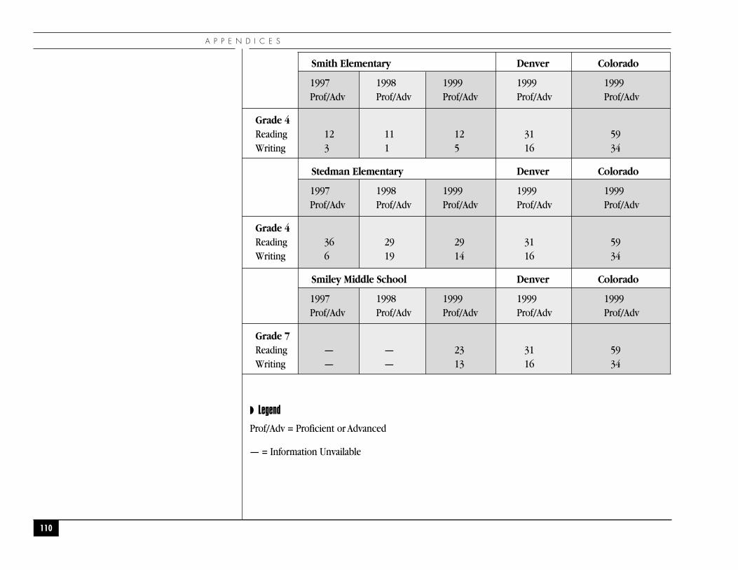
Smith Elementary Denver Colorado
1997 1998 1999 1999 1999Prof/Adv Prof/Adv Prof/Adv Prof/Adv Prof/Adv
Grade 4Reading 12 11 12 31 59Writing 3 1 5 16 34
Stedman Elementary Denver Colorado
1997 1998 1999 1999 1999Prof/Adv Prof/Adv Prof/Adv Prof/Adv Prof/Adv
Grade 4Reading 36 29 29 31 59Writing 6 19 14 16 34
Smiley Middle School Denver Colorado
1997 1998 1999 1999 1999Prof/Adv Prof/Adv Prof/Adv Prof/Adv Prof/Adv
Grade 7Reading — — 23 31 59Writing — — 13 16 34
◗ Legend
Prof/Adv = Proficient or Advanced
— = Information Unvailable
A P P E N D I C E S
110
P A R K H I L L N E I G H B O R H O O D P L A N
111
�E C O N O M I C A N DE M P L O Y M E N TC H A R A C T E R I S T I C S
�
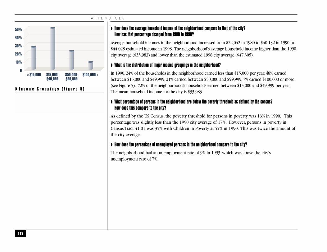
A P P E N D I C E S
◗ How does the average household income of the neighborhood compare to that of the city? How has that percentage changed from 1980 to 1990?
Average household incomes in the neighborhood increased from $22,042 in 1980 to $40,132 in 1990 to$44,028 estimated income in 1998. The neighborhood’s average household income higher than the 1990city average ($33,983) and lower than the estimated 1998 city average ($47,305).
◗ What is the distribution of major income groupings in the neighborhood?
In 1990, 24% of the households in the neighborhood earned less than $15,000 per year; 48% earnedbetween $15,000 and $49,999; 21% earned between $50,000 and $99,999; 7% earned $100,000 or more(see Figure 5). 72% of the neighborhood’s households earned between $15,000 and $49,999 per year.The mean household income for the city is $33,983.
◗ What percentage of persons in the neighborhood are below the poverty threshold as defined by the census? How does this compare to the city?
As defined by the US Census, the poverty threshold for persons in poverty was 16% in 1990. Thispercentage was slightly less than the 1990 city average of 17%. However, persons in poverty inCensus Tract 41.01 was 35% with Children in Poverty at 52% in 1990. This was twice the amount ofthe city average.
◗ How does the percentage of unemployed persons in the neighborhood compare to the city?
The neighborhood had an unemployment rate of 9% in 1993, which was above the city’sunemployment rate of 7%.
112
◗ I n c o m e G r o u p i n g s ( F i g u r e 5 )
10%
0
20%
30%
40%
50%
<$15,000 $15,000-$49,999
$50,000-$99,999
$100,000+
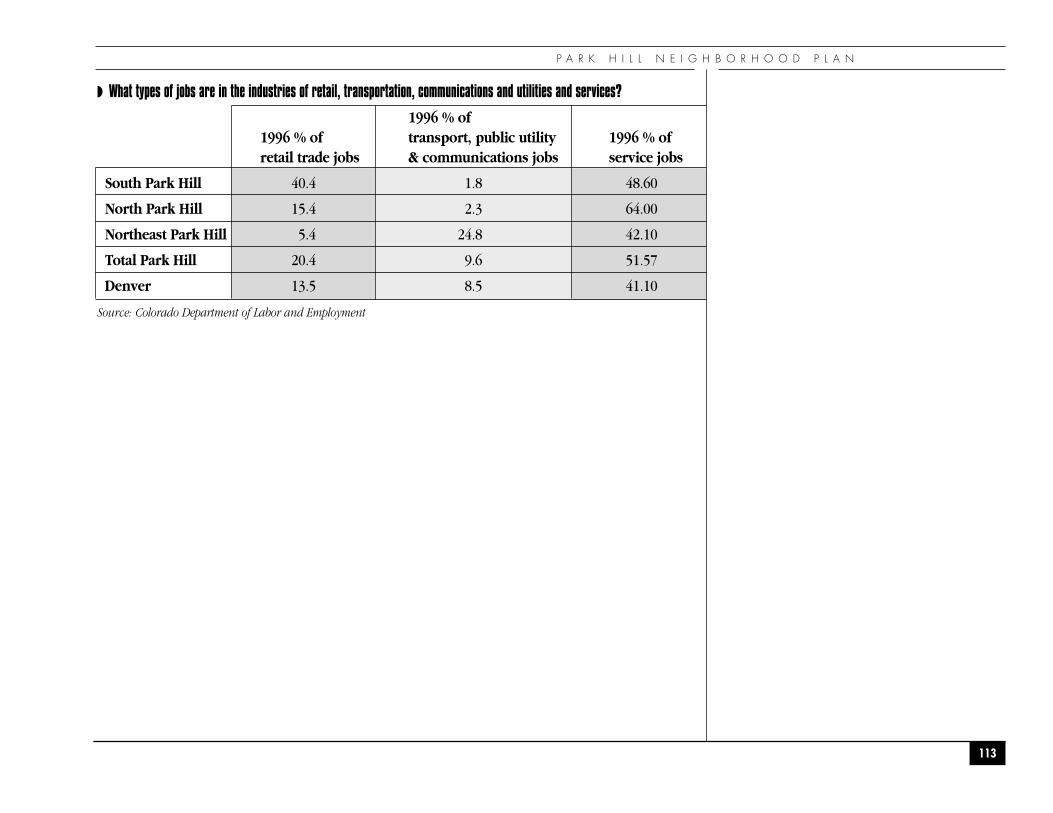
◗ What types of jobs are in the industries of retail, transportation, communications and utilities and services?
1996 % of1996 % of transport, public utility 1996 % ofretail trade jobs & communications jobs service jobs
South Park Hill 40.4 1.8 48.60
North Park Hill 15.4 2.3 64.00
Northeast Park Hill 5.4 24.8 42.10
Total Park Hill 20.4 9.6 51.57
Denver 13.5 8.5 41.10
Source: Colorado Department of Labor and Employment
P A R K H I L L N E I G H B O R H O O D P L A N
113
A P P E N D I C E S
114
�L A N D U S E A N D Z O N I N G�
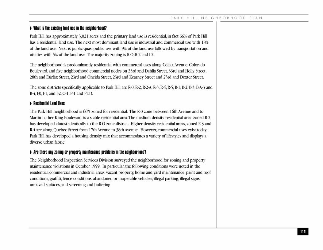
P A R K H I L L N E I G H B O R H O O D P L A N
◗ What is the existing land use in the neighborhood?
Park Hill has approximately 3,021 acres and the primary land use is residential, in fact 66% of Park Hillhas a residential land use. The next most dominant land use is industrial and commercial use with 18%of the land use. Next is public-quasi-public use with 9% of the land use followed by transportation andutilities with 5% of the land use. The majority zoning is R-O, R-2 and I-2.
The neighborhood is predominantly residential with commercial uses along Colfax Avenue, ColoradoBoulevard, and five neighborhood commercial nodes on 33rd and Dahlia Street, 33rd and Holly Street,28th and Fairfax Street, 23rd and Oneida Street, 23rd and Kearney Street and 23rd and Dexter Street.
The zone districts specifically applicable to Park Hill are R-0, R-2, R-2-A, R-3, R-4, R-5, B-1, B-2, B-3, B-A-3 andB-4, I-0, I-1, and I-2, O-1, P-1 and PUD.
◗ Residential Land Uses
The Park Hill neighborhood is 66% zoned for residential. The R-0 zone between 16th Avenue and toMartin Luther King Boulevard, is a stable residential area.The medium density residential area, zoned R-2,has developed almost identically to the R-O zone district. Higher density residential areas, zoned R-3 andR-4 are along Quebec Street from 17th Avenue to 38th Avenue. However, commercial uses exist today.Park Hill has developed a housing density mix that accommodates a variety of lifestyles and displays adiverse urban fabric.
◗ Are there any zoning or property maintenance problems in the neighborhood?
The Neighborhood Inspection Services Division surveyed the neighborhood for zoning and propertymaintenance violations in October 1999. In particular, the following conditions were noted in theresidential, commercial and industrial areas: vacant property, home and yard maintenance, paint and roofconditions, graffiti, fence conditions, abandoned or inoperable vehicles, illegal parking, illegal signs,unpaved surfaces, and screening and buffering.
115
A P P E N D I C E S
The results of the sample survey indicate that properties had the following code enforcementviolations in the neighborhood:
◗ Residential:
◗ Yards with trash and unattended vegetation
◗ Vacant and derelict buildings
◗ Alleys not maintained with uncontained trash, waste material and weed
◗ Unpaved alleys
◗ Junk yards
◗ Vacant lots with uncontained trash, waste materials, and weeds over 6" in height.
◗ Storage of miscellaneous debris
◗ Storage of construction material and equipment.
◗ Inoperable, dismantled or wrecked vehicles
◗ Interior household furniture and appliances stored outside
◗ Unpaved/off street parking
◗ Boats and Trailers parked or stored on street
◗ Recreation Vehicles over 22’ parked in a residential area
◗ Shed or storage buildings into side setback
◗ Truck tractors and semi-trailers parked in residential areas
◗ Boat/Trailer parked in front setback areas and parked or stored on street
◗ Sheds erected without permits or built into the side setbacks
116
P A R K H I L L N E I G H B O R H O O D P L A N
◗ Fences erected without permits and illegal materials
◗ Dilapidated fences
◗ Too many dogs and cats
◗ Commercial vehicles and dump trucks parked in residential areas
◗ Graffiti
◗ Damaged roofs and gutters
◗ Broken windows and screens
◗ Commercial
◗ Trash dumpsters unemptied
◗ Standing water and grading problems in parking lots
◗ Signs advertising uses that are non-existent
◗ Portable signs
◗ Landscaping
◗ Façade and exterior improvements needed
◗ Uncontained trash
◗ Vacant lots not maintained
◗ Auto repair shops not maintaining landscaping and proper screening
◗ Indefinite storage of vehicles
◗ Furniture outdoor display and sales
◗ Weeds in Right-of-way
117
A P P E N D I C E S
◗ Failure to maintain off-street parking areas, unpaved surfaces
◗ Industrial
◗ Trash and weeds
◗ Unscreened storage
◗ Unsurfaced parking for industrial uses
◗ Screening fences adjacent to residential
◗ Buffering
118
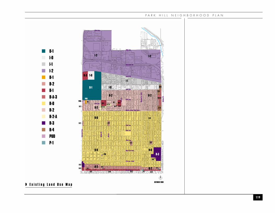
P A R K H I L L N E I G H B O R H O O D P L A N
119
R-4
R-0
R-2
R-0
R-0 R-0
R-2 R-2
B-2
I-2 I-2
I-1
I-0
B-3
O-1
1-0B-3
PUDPUD
B-2 B-2
B-2
R-2 R-2
R-2-AR-2-A
B-1 B-3
B-2B-2R-4
R-4
R-4
R-3
B-2
P-1
P-1
B-4
B-1
B-A-3
B-4
B-4 B-4B-4
R-5
R-3P-1
PUD
B-1
OCTOBER 1999
Interstate 70
38th Ave.
Smith Rd.
35th Ave.
34th Ave.
Martin Luther King Blvd.
23rd Ave.
Montview Blvd.
26th Ave.
17th Ave. Pkwy.
Colfax Ave.
48th Ave.
Colo
rado
Blv
d.
Dahl
ia S
t.
Elm
St.
Holly
St.
Mon
aco
St. P
kwy.
Queb
ec S
t.
28th Ave.
52nd Ave.
N
◗ E x i s t i n g L a n d U s e M a p
0-1
I-0
I-1
I-2
B-1
B-2
B-1
B-A-3
R-0
R-2
R-2-A
R-3
PUDR-4
P-1
A P P E N D I C E S
120
�H O U S I N G�
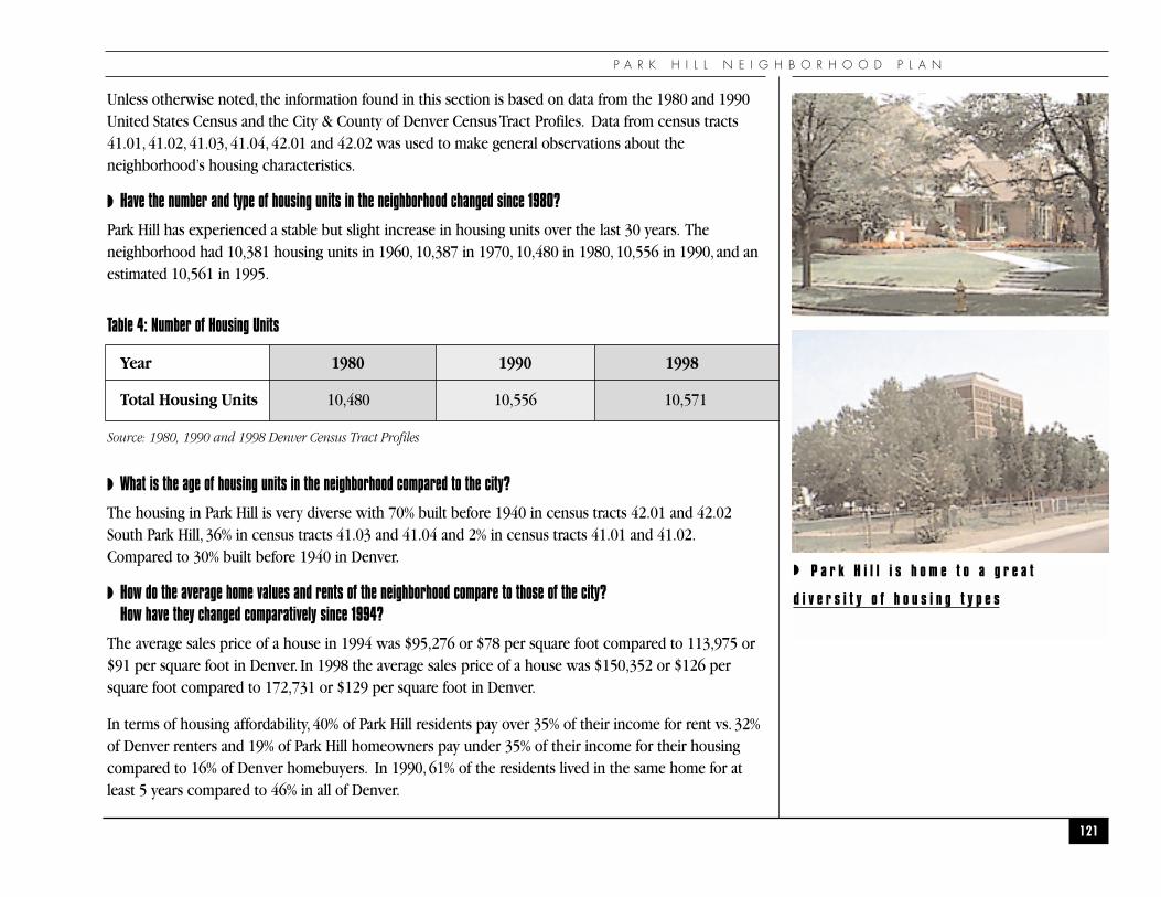
P A R K H I L L N E I G H B O R H O O D P L A N
121
Unless otherwise noted, the information found in this section is based on data from the 1980 and 1990United States Census and the City & County of Denver Census Tract Profiles. Data from census tracts41.01, 41.02, 41.03, 41.04, 42.01 and 42.02 was used to make general observations about theneighborhood’s housing characteristics.
◗ Have the number and type of housing units in the neighborhood changed since 1980?
Park Hill has experienced a stable but slight increase in housing units over the last 30 years. Theneighborhood had 10,381 housing units in 1960, 10,387 in 1970, 10,480 in 1980, 10,556 in 1990, and anestimated 10,561 in 1995.
Table 4: Number of Housing Units
Year 1980 1990 1998
Total Housing Units 10,480 10,556 10,571
Source: 1980, 1990 and 1998 Denver Census Tract Profiles
◗ What is the age of housing units in the neighborhood compared to the city?
The housing in Park Hill is very diverse with 70% built before 1940 in census tracts 42.01 and 42.02South Park Hill, 36% in census tracts 41.03 and 41.04 and 2% in census tracts 41.01 and 41.02.Compared to 30% built before 1940 in Denver.
◗ How do the average home values and rents of the neighborhood compare to those of the city? How have they changed comparatively since 1994?
The average sales price of a house in 1994 was $95,276 or $78 per square foot compared to 113,975 or$91 per square foot in Denver. In 1998 the average sales price of a house was $150,352 or $126 persquare foot compared to 172,731 or $129 per square foot in Denver.
In terms of housing affordability, 40% of Park Hill residents pay over 35% of their income for rent vs. 32%of Denver renters and 19% of Park Hill homeowners pay under 35% of their income for their housingcompared to 16% of Denver homebuyers. In 1990, 61% of the residents lived in the same home for atleast 5 years compared to 46% in all of Denver.
◗ P a r k H i l l i s h o m e t o a g r e a t
d i v e r s i t y o f h o u s i n g t y p e s
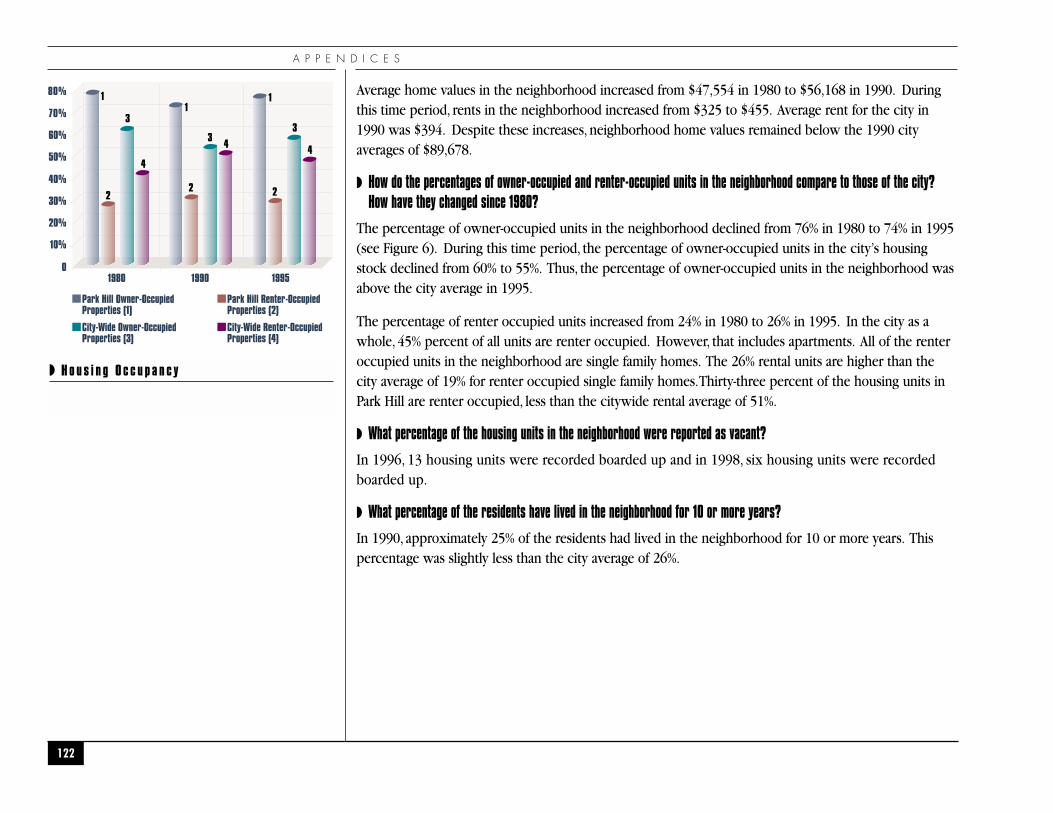
A P P E N D I C E S
Average home values in the neighborhood increased from $47,554 in 1980 to $56,168 in 1990. Duringthis time period, rents in the neighborhood increased from $325 to $455. Average rent for the city in1990 was $394. Despite these increases, neighborhood home values remained below the 1990 cityaverages of $89,678.
◗ How do the percentages of owner-occupied and renter-occupied units in the neighborhood compare to those of the city? How have they changed since 1980?
The percentage of owner-occupied units in the neighborhood declined from 76% in 1980 to 74% in 1995(see Figure 6). During this time period, the percentage of owner-occupied units in the city’s housingstock declined from 60% to 55%. Thus, the percentage of owner-occupied units in the neighborhood wasabove the city average in 1995.
The percentage of renter occupied units increased from 24% in 1980 to 26% in 1995. In the city as awhole, 45% percent of all units are renter occupied. However, that includes apartments. All of the renteroccupied units in the neighborhood are single family homes. The 26% rental units are higher than thecity average of 19% for renter occupied single family homes.Thirty-three percent of the housing units inPark Hill are renter occupied, less than the citywide rental average of 51%.
◗ What percentage of the housing units in the neighborhood were reported as vacant?
In 1996, 13 housing units were recorded boarded up and in 1998, six housing units were recordedboarded up.
◗ What percentage of the residents have lived in the neighborhood for 10 or more years?
In 1990, approximately 25% of the residents had lived in the neighborhood for 10 or more years. Thispercentage was slightly less than the city average of 26%.
122
◗ H o u s i n g O c c u p a n c y
10%
0
20%
30%
40%
50%
60%
70%
80%
1980 1990 1995
Park Hill Owner-OccupiedProperties (1)
Park Hill Renter-OccupiedProperties (2)
City-Wide Owner-OccupiedProperties (3)
City-Wide Renter-OccupiedProperties (4)
1 11
22 2
3
33
4
4 4
P A R K H I L L N E I G H B O R H O O D P L A N
123
�S T R E E T S , T R A F F I C , A N DP U B L I C T R A N S P O R T A T I O N
�
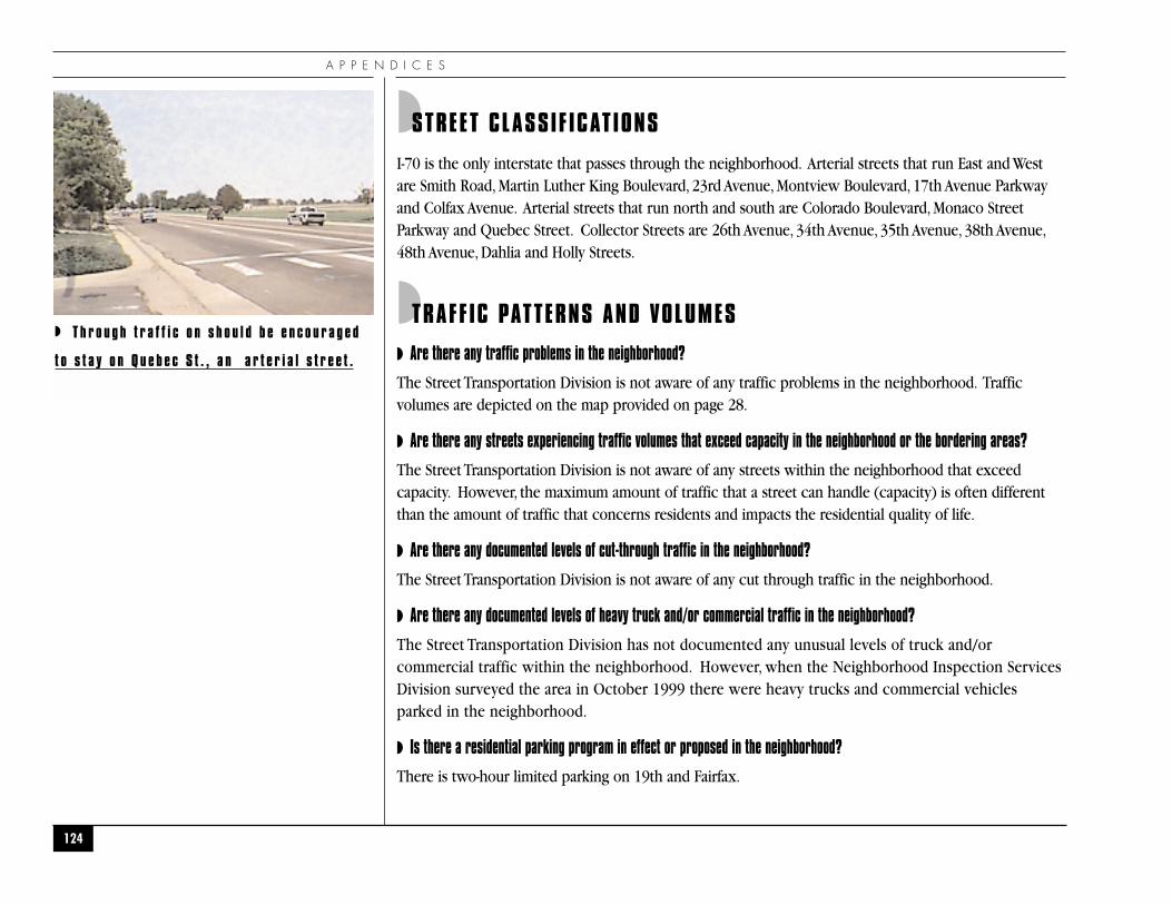
A P P E N D I C E S
◗STREET CLASSIF ICATIONS
I-70 is the only interstate that passes through the neighborhood. Arterial streets that run East and Westare Smith Road, Martin Luther King Boulevard, 23rd Avenue, Montview Boulevard, 17th Avenue Parkwayand Colfax Avenue. Arterial streets that run north and south are Colorado Boulevard, Monaco StreetParkway and Quebec Street. Collector Streets are 26th Avenue, 34th Avenue, 35th Avenue, 38th Avenue,48th Avenue, Dahlia and Holly Streets.
◗TRAFF IC PATTERNS AND VOLUMES
◗ Are there any traffic problems in the neighborhood?
The Street Transportation Division is not aware of any traffic problems in the neighborhood. Trafficvolumes are depicted on the map provided on page 28.
◗ Are there any streets experiencing traffic volumes that exceed capacity in the neighborhood or the bordering areas?
The Street Transportation Division is not aware of any streets within the neighborhood that exceedcapacity. However, the maximum amount of traffic that a street can handle (capacity) is often differentthan the amount of traffic that concerns residents and impacts the residential quality of life.
◗ Are there any documented levels of cut-through traffic in the neighborhood?
The Street Transportation Division is not aware of any cut through traffic in the neighborhood.
◗ Are there any documented levels of heavy truck and/or commercial traffic in the neighborhood?
The Street Transportation Division has not documented any unusual levels of truck and/orcommercial traffic within the neighborhood. However, when the Neighborhood Inspection ServicesDivision surveyed the area in October 1999 there were heavy trucks and commercial vehiclesparked in the neighborhood.
◗ Is there a residential parking program in effect or proposed in the neighborhood?
There is two-hour limited parking on 19th and Fairfax.
124
◗ T h r o u g h t r a f f i c o n s h o u l d b e e n c o u r a g e d
t o s t a y o n Q u e b e c S t . , a n a r t e r i a l s t r e e t .
P A R K H I L L N E I G H B O R H O O D P L A N
◗PUBLIC TRANSPORTATION
◗ Which transit routes serve the neighborhood?
Park Hill is served by several Regional Transportation District Routes. Routes 15, 20, 28, 38, 40, 43, 44, 65and 105. These routes provide for adequate neighborhood geographic coverage based on walkingdistance to bus stops. However, there are few East and West routes (15, 20, 28, 38, and 44) for such alarge residential oriented neighborhood.
125
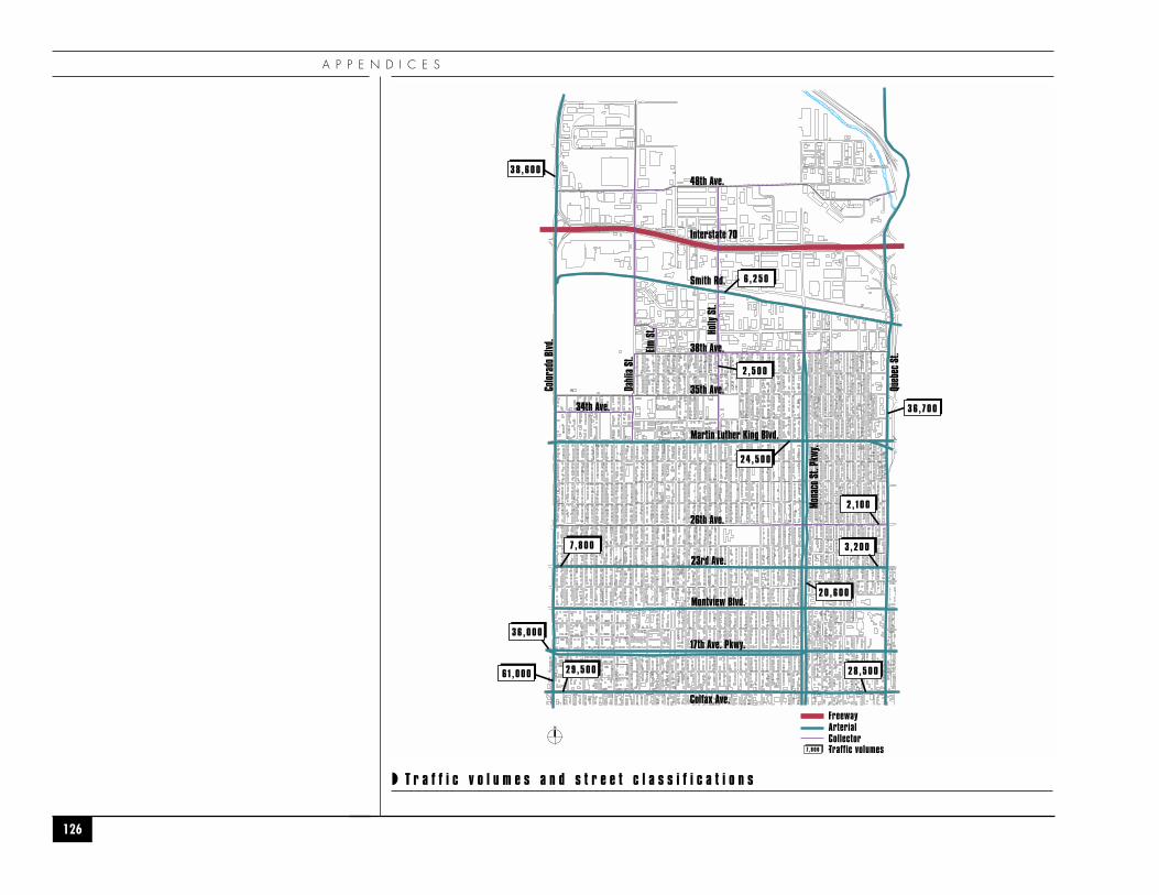
A P P E N D I C E S
126
◗ T r a f f i c v o l u m e s a n d s t r e e t c l a s s i f i c a t i o n s
Martin Luther King Blvd.
23rd Ave.
Montview Blvd.
26th Ave.
38th Ave.
48th Ave.
Smith Rd.
Interstate 70
35th Ave.
34th Ave.
Dahl
ia S
t.
Elm S
t.
Color
ado
Blvd
.
Queb
ec S
t.
Mona
co S
t. Pk
wy.
Holly
St.
17th Ave. Pkwy.
Colfax Ave.
3 6 , 7 0 0
3 8 , 6 0 0
2 0 , 6 0 0
6 1 , 0 0 0
2 , 5 0 0
6 , 2 5 0
2 4 , 5 0 0
2 , 1 0 0
7 , 8 0 0 3 , 2 0 0
3 6 , 0 0 0
2 8 , 5 0 02 9 , 5 0 0
N
FreewayArterialCollector
7 , 8 0 0 Traffic volumes
P A R K H I L L N E I G H B O R H O O D P L A N
127
�I N F R A S T R U C T U R E�
A P P E N D I C E S
◗STREETS, SIDEWALKS, AND ALLEYS
◗ Are there any unpaved streets in the neighborhood?
There are no unpaved streets in the neighborhood.
◗ Are there any alleys in the neighborhood?
Yes. Alley conditions were included as part of the survey conducted by the Neighborhood InspectionServices Division. This survey indicated there are several unpaved alleys in the neighborhood andalleys that had moderate amounts of vegetation or trash in October 1999. There are approximately fivealleys unimproved.
◗ What is the general condition of the street pavement in each of the neighborhoods?
Please refer to the attached map and list for the 2000 street maintenance work program. Streets withdeficient pavements are scheduled for a maintenance treatment (mill and overlay, chipseal, crackseal),dependant on the type of deficiency and budgetary constraints.
◗ Does the neighborhood have adequate street lighting?
There needs to be a survey or audit in the neighborhood to identify areas where additional streetlights are needed.
The typical spacing between street lights in older areas of the City such as Park Hill is 300 feet or onestreet light at each public street intersection whichever distance works out to be the lesser spacing apart.Residents will have to be willing to grant Public Service Company an overhead electric easement fromthe alley or rear of their property if a new pole is required in order to install a new street light in theirblock. That can frequently be a stumbling block to installing additional streetlights in established areas.
Public Service Company would be the one to prepare an inventory of existing street light locations forPark Hill. Public Service Company can provide the location of existing streetlights and any proposedlocations for additional lighting.
◗ Are there any issues related to the facilities and services provided by the Street Transportation Division not addressed above that are a problem in the neighborhood?
There are a significant number of faded and/or vandalized traffic signs in these four neighborhoods. Stop
128
P A R K H I L L N E I G H B O R H O O D P L A N
Signs seem to be the favorite target for vandals and taggers. Parking Signs and Street Name Signs are generallyjust faded and in need of replacement. This would be a good time to replace the Street Name Signs in theseneighborhoods since we have recently redone our Street Name Sign standards which now specify larger,morelegible copy with more durable sign face sheeting and a much higher level of reflectivity to make them easierto read at night. Street Name Signs is one of may elements in the neighborhood that will improve the qualityof life for residents because they will improve emergency vehicle response time and are easier to read. Anyexisting School Zones in these four neighborhoods that have not yet been upgraded to the new FlorescentYellow Green signs that the City began using in 1998 should be scheduled for sign replacement.
◗WATER
◗ What is the availability of water within the neighborhood?
According to the Water Services Department, water is available from mains in streets and/or alleysthroughout the neighborhood.
◗ Are there any recent Capital Improvement Programs (CIP) water main projects within the neighborhood?
There are no recent CIP water main projects within the neighborhood.
◗SANITARY SEWER
◗ What is the availability of sanitary sewers within the neighborhood?
According to the Wastewater Engineering Division, sanitary sewer lines are available in streets and/oralleys throughout the neighborhood.
◗STORM DRAINAGE
◗ Are you aware of any unique storm drainage issues not addressed above that are a problem in the neighborhood?
There are no unique storm drainage issues within the neighborhood.
129
A P P E N D I C E S
130
�P U B L I C S A F E T Y�
P A R K H I L L N E I G H B O R H O O D P L A N
◗POLICE PROTECTION
◗ Which police precinct serves the neighborhood?
Police District #4 serves the neighborhood, located at 3555 Colorado Boulevard.
◗ Have crime rates for the neighborhood been increasing or decreasing over the past three years?
The neighborhood will be divided into three different census tracts (41.01 and 41.02, 41.03 and 41.04,42.01 and 42.02) to correspond to the crime rankings for Denver Statistical Neighborhoods by rate. Thecrime rate rank for census tracts 41.01 and 41.02 has decreased from a rank of 10 to 15 from 1997 to1998.The total number of crimes committed in the census tracts was 912 in 1997 to 775 in 1998.Thecrime rate rank for census tracts 41.03 and 41.04 has slightly decreased from a rank of 62 to 63 from 1997to 1998.The total number of crimes committed in the census tracts was 490 in 1997 to 437 in 1998.Thecrime rate rank for census tracts 42.01 and 42.02 has increased from a rank of 50 to 46 from 1997 to1998.The total number of crimes committed in the census tracts was 567 in 1997 and 535 in 1998.
◗ Have any crime prevention programs been established in the neighborhood?
The neighborhood watch program has been active for several years.
◗F IRE PROTECTION
◗ Which fire station serves the neighborhood?
The neighborhood is served by Denver Fire Stations District #26 at 7045 E. 38th, District #14 at 1426Oneida St., and District #10 at 3200 Steele St.
◗ Are there any water pressure problems in providing fire service to the neighborhood?
The Fire Department is not aware of any water pressure or supply problems.
131
A P P E N D I C E S
132
�C O M M U N I T Y F A C I L I T I E S�
P A R K H I L L N E I G H B O R H O O D P L A N
◗PARKS, RECREATION AND L IRARY
◗ Which neighborhood parks serve the neighborhood?
The neighborhood is served by several neighborhood parks, City of Axum Park, located at M.L. King Blvd.& Cherry St., Ferguson Park, at 23rd Avenue and Dexter St., Martin Luther King Park at 38th Avenue andNewport St., Milan Park, at Martin Luther King and Quebec and Fred Thomas Park, at 26th Avenue andQuebec St. Denver City Park is located West of Colorado Blvd. from 17th to 26th Avenues.
◗ What types of recreation programs are provided at these Parks?
The Parks provide outdoor games such as basketball, tennis and football. Also included are sportsleagues; a teen room; special classes; summer, after school and drop in recreation programs; seniorprograms, special events and field trips.
◗ What is the nearest recreation centers to the neighborhood?
There are several recreation centers and programs that serve the residents of Park Hill, as well as, otherswho do not reside in this community. These include Martin Luther King Recreation Center located at3880 Newport St., Skyland Recreation Center at 3334 Holly St., Park Hill Golf Course and the City ParkGolf Course.
◗ What types of services are available at the recreation centers?
The centers provide recreational activities and comprehensive sports programs for all ages. Organizedprograms are offered to ages three to seniors.
◗ Which library serves the neighborhood?
Park Hill has Denver Public Library Service from the Dahlia Branch Library, located at 3380 Dahlia Streetand the Park Hill Branch Library, located at 4705 Montview Boulevard. The libraries serve as acommunity center and gathering place for many civic and local residents, associations and institutions.
133
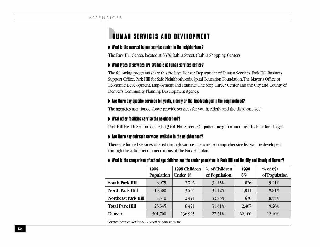
A P P E N D I C E S
134
◗HUMAN SERVICES AND DEVELOPMENT
◗ What is the nearest human service center to the neighborhood?
The Park Hill Center, located at 3376 Dahlia Street. (Dahlia Shopping Center)
◗ What types of services are available at human services center?
The following programs share this facility: Denver Department of Human Services, Park Hill BusinessSupport Office, Park Hill for Safe Neighborhoods, Spiral Education Foundation,The Mayor’s Office ofEconomic Development, Employment and Training: One Stop Career Center and the City and County ofDenver’s Community Planning Development Agency.
◗ Are there any specific services for youth, elderly or the disadvantaged in the neighborhood?
The agencies mentioned above provide services for youth, elderly and the disadvantaged.
◗ What other facilities service the neighborhood?
Park Hill Health Station located at 3401 Elm Street. Outpatient neighborhood health clinic for all ages.
◗ Are there any outreach services available in the neighborhood?
There are limited services offered through various agencies. A comprehensive list will be developedthrough the action recommendations of the Park Hill plan.
◗ What is the comparison of school age children and the senior population in Park Hill and the City and County of Denver?
1998 1998 Children % of Children 1998 % of 65+ Population Under 18 of Population 65+ of Population
South Park Hill 8,975 2,796 31.15% 826 9.21%
North Park Hill 10,300 3,205 31.12% 1,011 9.81%
Northeast Park Hill 7,370 2,421 32.85% 630 8.55%
Total Park Hill 26,645 8,421 31.61% 2,467 9.26%
Denver 501,700 136,995 27.31% 62,188 12.40%
Source: Denver Regional Council of Governments
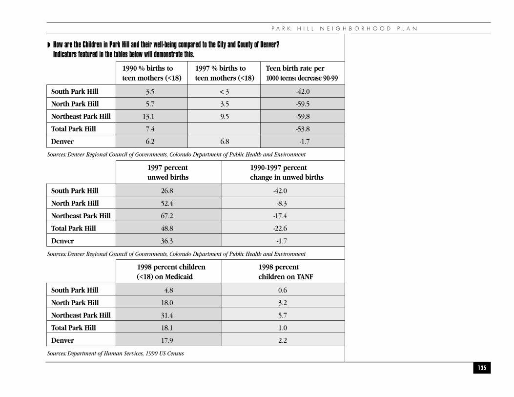
◗ How are the Children in Park Hill and their well-being compared to the City and County of Denver? Indicators featured in the tables below will demonstrate this.
1990 % births to 1997 % births to Teen birth rate perteen mothers (<18) teen mothers (<18) 1000 teens: decrease 90-99
South Park Hill 3.5 < 3 -42.0
North Park Hill 5.7 3.5 -59.5
Northeast Park Hill 13.1 9.5 -59.8
Total Park Hill 7.4 -53.8
Denver 6.2 6.8 -1.7
Sources: Denver Regional Council of Governments, Colorado Department of Public Health and Environment
1997 percent 1990-1997 percent unwed births change in unwed births
South Park Hill 26.8 -42.0
North Park Hill 52.4 -8.3
Northeast Park Hill 67.2 -17.4
Total Park Hill 48.8 -22.6
Denver 36.3 -1.7
Sources: Denver Regional Council of Governments, Colorado Department of Public Health and Environment
1998 percent children 1998 percent (<18) on Medicaid children on TANF
South Park Hill 4.8 0.6
North Park Hill 18.0 3.2
Northeast Park Hill 31.4 5.7
Total Park Hill 18.1 1.0
Denver 17.9 2.2
Sources: Department of Human Services, 1990 US Census
P A R K H I L L N E I G H B O R H O O D P L A N
135
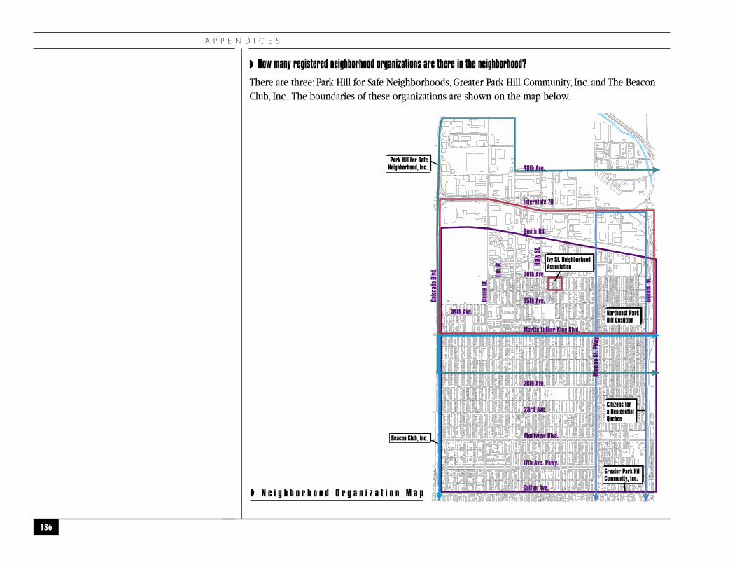
Martin Luther King Blvd.
23rd Ave.
Montview Blvd.
26th Ave.
38th Ave.
48th Ave.
Smith Rd.
Interstate 70
35th Ave.
34th Ave.
Dahl
ia S
t.
Elm S
t.
Color
ado
Blvd
.
Queb
ec S
t.
Holly
St.
17th Ave. Pkwy.
Colfax Ave.
Park Hill For SafeNeighborhood, Inc.
Beacon Club, Inc.
Ivy St. NeighborhoodAssociation
Northeast ParkHill Coalition
Citizens fora ResidentialQuebec
Greater Park HillCommunity, Inc.
Mona
co S
t. Pk
wy.
◗ N e i g h b o r h o o d O r g a n i z a t i o n M a p
A P P E N D I C E S
◗ How many registered neighborhood organizations are there in the neighborhood?
There are three; Park Hill for Safe Neighborhoods, Greater Park Hill Community, Inc. and The BeaconClub, Inc. The boundaries of these organizations are shown on the map below.
136
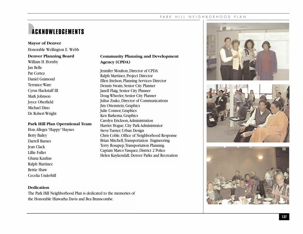
P A R K H I L L N E I G H B O R H O O D P L A N
137
◗ACKNOWLEDGEMENTS
Mayor of Denver
Honorable Wellington E. Webb
Denver Planning BoardWilliam H. HornbyJan BellePat Cortez Daniel GuimondTerrance WareCyrus Hackstaff IIIMark JohnsonJoyce OberfieldMichael DinoDr. Robert Wright
Park Hill Plan Operational TeamHon.Allegra “Happy”HaynesBetty BaileyDarrell BarnesJean ClackLillie FullerGhana Kaulius Ralph MartinezBettie ShawCecelia Underhill
Community Planning and DevelopmentAgency (CPDA)
Jennifer Moulton, Director of CPDA Ralph Martinez, Project Director Ellen Ittelson, Planning Services Director Dennis Swain, Senior City PlannerJanell Flaig, Senior City PlannerDoug Wheeler, Senior City PlannerJulius Zsako, Director of CommunicationsJim Ottenstein, GraphicsJulie Connor, GraphicsKen Barkema, Graphics Carolyn Erickson,Administration Harriet Hogue, City Park AdministratorSteve Turner, Urban Design Chris Coble, Office of Neighborhood ResponseBrian Mitchell,Transportation EngineeringTerry Rosapep,Transportation Planning Captain Marco Vasquez, District 2 Police Helen Kuykendall, Denver Parks and Recreation
DedicationThe Park Hill Neighborhood Plan is dedicated to the memories ofthe Honorable Hiawatha Davis and Bea Branscombe.
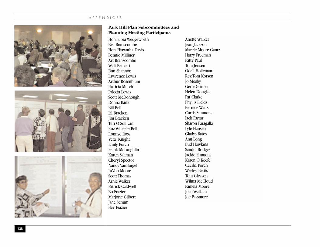
A P P E N D I C E S
138
Park Hill Plan Subcommittees and Planning Meeting Participants
Hon. Elbra Wedgeworth Bea BranscombeHon. Hiawatha DavisBennie MillinerArt BranscombeWalt BeckertDan ShannonLawrence LewisArthur RosenblumPatricia MutchPalecia LewisScott McDonoughDonna BankBill BellLil BrackenJim BrackenTeri O’SullivanRoz Wheeler-BellRonnye RossVera KnightEmily PorchFrank McLaughlinKaren SalimanCheryl SpectorNancy VanBurgelLaVon MooreScott ThomasArnie WalkerPatrick CaldwellBo FrazierMarjorie GilbertJane SchumBev Frazier
Anette WalkerJean JacksonMarcie Moore GantzHarry FreemanPatty PaulTom JensenOdell HollemanRev.Tom KorsenJo MosbyGerie GrimesHelen DouglasPat ClarkePhyllis FieldsBernice WattsCurtis SimmonsJack FarrarSharon FaragallaLyle HansenGladys BatesAnn LongBud HawkinsSandra BridgesJackie EmmonsKaren O’KeefeCecilia PorchWesley BettisTom GleasonWilma McCloudPamela MooreJoan WallachJoe Passmore
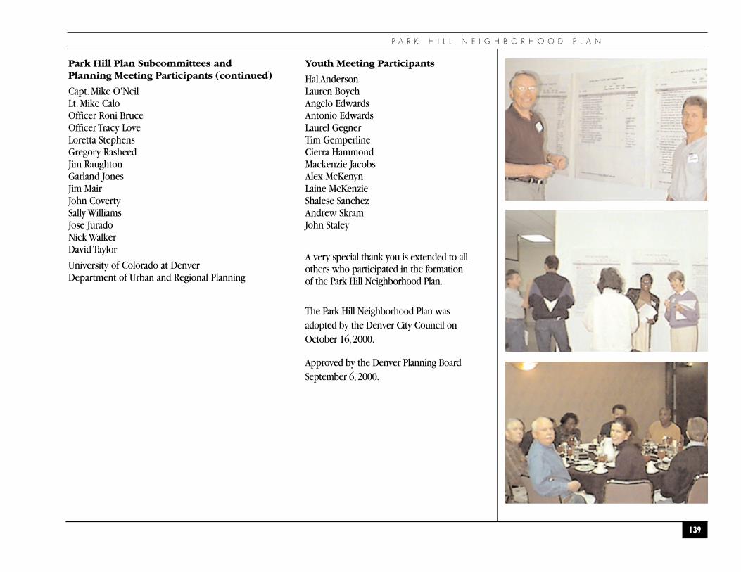
P A R K H I L L N E I G H B O R H O O D P L A N
139
Park Hill Plan Subcommittees and Planning Meeting Participants (continued)
Capt. Mike O’NeilLt. Mike CaloOfficer Roni BruceOfficer Tracy LoveLoretta StephensGregory RasheedJim RaughtonGarland JonesJim MairJohn CovertySally WilliamsJose JuradoNick WalkerDavid Taylor
University of Colorado at DenverDepartment of Urban and Regional Planning
Youth Meeting Participants
Hal AndersonLauren BoychAngelo EdwardsAntonio EdwardsLaurel GegnerTim GemperlineCierra HammondMackenzie JacobsAlex McKenynLaine McKenzieShalese SanchezAndrew SkramJohn Staley
A very special thank you is extended to allothers who participated in the formationof the Park Hill Neighborhood Plan.
The Park Hill Neighborhood Plan wasadopted by the Denver City Council onOctober 16,2000.
Approved by the Denver Planning BoardSeptember 6,2000.