Embed Size (px)
Citation preview
PARK FARM, THORNBURY, SOUTH GLOUCESTERSHIRE DOCUMENTARY RESEARCH REPORT by Dr Christopher Phillpotts BA MA PhD AIFA for Cotswold Archaeology October 2010
1
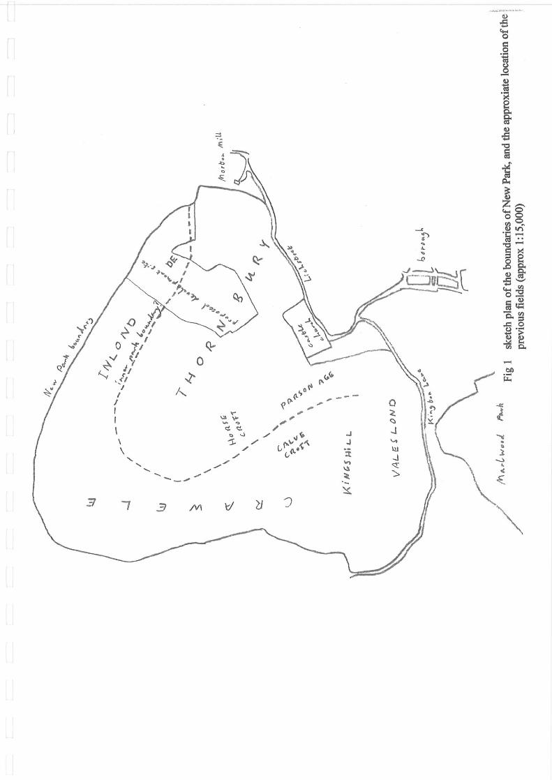
CONTENTS 1. Introduction 2. Saxo-Norman Thornbury 3. The Earldom of Gloucester Period 4. The Audley and Stafford Period 5. Edward Stafford and the New Park 6. Henry VIII’s Occupation 7. The Later Staffords 8. Thornbury Park 9. Conclusion 10. Bibliography ILLUSTRATIONS Fig 1 sketch plan of the boundaries of New Park, and the approxiate location of the
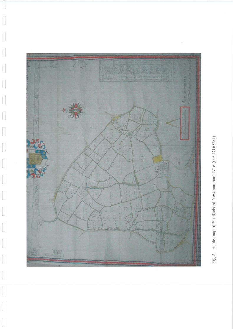
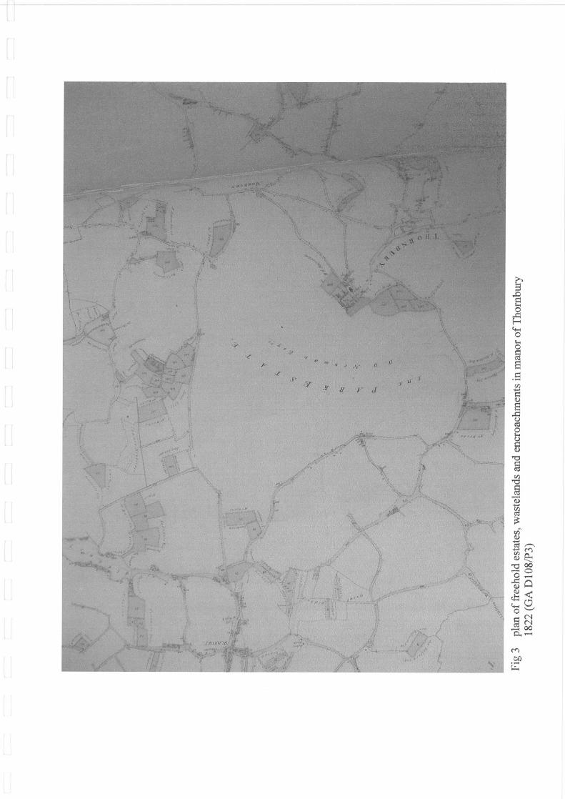
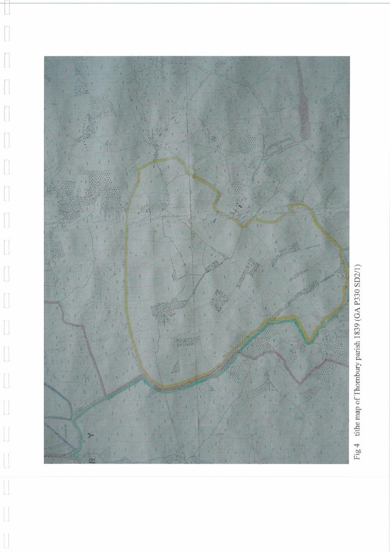
previous fields (approx 1:15,000) Fig 2 estate map of Sir Richard Newman bart 1716 (GA D1655/1) Fig 3 plan of freehold estates, wastelands and encroachments in manor of Thornbury
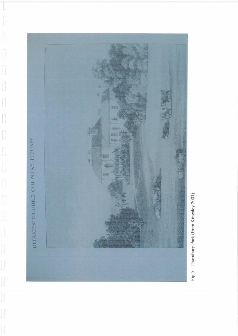
1822 (GA D108/P3) Fig 4 tithe map of Thornbury parish 1839 (GA P330 SD2/1) Fig 5 Thornbury Park (from Kingsley 2001)
2
1. Introduction 1.1 This documentary research report was commissioned by Cotswold Archaeology in August 2010, and concerns a 26-hectare site at Park Farm, Thornbury, in South Gloucestershire (central grid ref ST 6368 9146). This consists of five pasture fields and has been proposed as the site of a housing development; it is immediately adjacent to the Thornbury Conservation Area to the south-west. The site has previously been the subject of an archaeological desk-based assessment compiled by Cotswold Archaeology in March 2010. It is likely that the interpretation of the site will be considerably enhanced by research into the documentary sources. This research report forms part of an extensive investigation of the heritage content of the site, undertaken before the determination of planning consent, which also includes an archaeological desk-based assessment, a geophysical survey, a Lidar survey and an archaeological field evaluation. 1.2 This report follows on from an initial documentary research assessment completed in July 2010, the purpose of which was to assess the numbers and types of surviving docu-mentary sources for the history of the site, in order to determine their contribution to a full study of the proposed development area. This was compiled in accordance with a Written Scheme of Investigation for documentary research, drawn up by Cotswold Archaeology in June 2010, and approved by David Haigh, the South Gloucestershire Manager, Natural and Built Environment, in July 2010. 1.3 The research is largely based on manuscripts held at the British Library at Euston (BL), the National Archives at Kew (NA), Staffordshire Record Office at Stafford (StRO), and Gloucestershire Archives at Gloucester (GA). There appears to be no relevant material at Bristol Record Office. 1.4 The site is associated with a broad range of surviving documentation of the late medieval and early modern periods. Extensive runs of manorial material from Thornbury dating from the 14th to the 16th century are now divided between London, Stafford and Gloucester. In the initial documentary research assessment, the documents were selected for their research potential, concentrating on surveys of the manor and the accounts of manorial officers. These were chosen because they may include information about the construction and maintenance of the New Park, and the operation of the agricultural fields which preceded it. The assessment did not include the equally extensive runs of manorial court records, and generally not routine rentals, which are both more informative about the tenants of the manor. The selection was therefore appropriate to the requirements of the full study of the proposed development area. 1.5 All the printed material listed in the initial documentary research assessment was consulted, and all the plans and surveys listed were reviewed, where available (one had to be retrieved from the conservation department at GA, and one could not be found). Apart from the very fine estate map of 1716 (already illustrated in the desk-based assessment), there do not appear to be any surviving plans of the park before the 19th century. The figures include a selection of these plans.
3
1.6 Because of the large volume of relevant potential source material in manuscript a sampling approach to the long runs of medieval and early modern manorial material was adopted. The manuscipts were selected for target periods when the New Park was constructed, or when it is thought to have been refurbished, or for mentions of Park Farm and Thornbury House. There was a danger in these predetermined selections that the research would only amplify and clarify those facts already known about the Park, and would not attend to preceding agricultural landscape and succeeding amenity park. Therefore the remaining documentation was sampled on a random base of every tenth accounting year (or the nearest available) from the 14th century to the 16th century. The selected manuscripts were indicated in the initial documentary research assessment, and the sampling approach was approved by David Haigh. 1.7 Some slight changes were introduced during the research process because some documents proved to be of different dates than in the catalogue (GA M108/M121 dates to 1396/7, not 1480/1; StRO D641/1/2/191 was from 1462/3, not 1474/5), and some documents were substituted for others, but this caused no serious difficulties. It was intended that when this sampling proceedure produced notable evidence of activity in the landscape at particular periods, the accounts of the intervening years would also be consulted; in fact no obvious additional target periods were identified. 1.8 All dates are expressed in New Style (post 1751 calendar), with the year beginning on 1st January.
4
2. Saxo-Norman Thornbury 2.1 The medieval parish of Thornbury was very large and probably represented a late Saxon estate stretching from the marshes of the Severn shore to the high ground and the Roman road to the east. The Severn marshes are known to have been embanked, drained and exploited for agriculture in the Roman period, but the line of sea defences was not always on the same alignment as the medieval sea-walls, and it may be doubted that occupation was continuous throughout the intervening Saxon period (Allen 1992, 87-8). Much of the woodland of Gloucestershire probably regenerated in the post-Roman period; the woods were then progressively cleared again from the lands of the former villa estates in the middle and late Saxon periods. 2.2 Thornbury may be first mentioned in an agreement of 896 between Bishop Wærferth of Worcester and Æthelwold concerning woodlands in Gloucestershire, including one at Thornbyrig (Sawyer 1968 no 1441). The early medieval manor house on the site of Thornbury Castle and the parish church of St Mary lay in close association, and formed the original focus of settlement. There was probably already a church by the late Saxon period. This area of early settlement was later abandoned when the borough of Thornbury was formed further to the south (Leech 1974, 22). It is indicated by the pre-Conquest features, and pits and gulleys dated between the 12th and mid-14th centuries found in a trial excavation and watching brief at the Vicarage in Church Street. They were succeeded by a period of cultivation (Cotswold Archaeology 2010a, App A no 3). 2.3 In 1066 the manor was one of those held by Beorhtric son of Ælfgar, who had four ploughs on his demesne land here, while his tenants operated a further 21 ploughs. There were two mills and a market, and there was still woodland measuring 1 league long by 1 league (2.4km) broad. The advance of cultivation had probably already divided it into the separate woodlands of Eastwood in the north-east of the manor, and Marlwood and Vilner Wood on its southern borders. Later the land belonged to Queen Matilda, who died in 1083, and by the time of the Domesday Book survey of 1086 it was in the hands of King William. The reeve had built a third mill and there was meadowland producing an annual rent of 40s. The manor had economic connections with Droitwich, from which it derived a rent in salt, and Gloucester, where it held a fishery (Williams and Martin 2002, 450; Franklin 1989, 150-1). 2.4 It is thought that the estuarine alluvial part of the manor was already fully used for arable production by the late 11th century, and was not unreclaimed marshland (Allen 1992, 96). The landscape evidence for this may be open to other interpretations, however.
5
3. The Earldom of Gloucester Period 3.1 In the 12th and 13th centuries Thornbury manor was part of the earldom of Gloucester. It was held by Robert fitzHamon in the 1090s, followed by his son-in-law and Henry I’s son Robert the Consul (d1147), then his son William (d1183), both earls of Gloucester. After a considerable period of detention by the Crown, the earldom descended to the Gilbert de Clare in 1217. Gilbert’s widow Isabel married Richard, earl of Cornwall, the brother of Henry III, in 1231, and he held the manor until 1243 when his step-son Richard de Clare came of age. Successive generations of the Clare family, earls of Gloucester and Hertford, held the manor until the death of Gilbert de Clare at the battle of Bannockburn in June 1314 (Atkyns 1712, 400; Caffall 1989, 7). 3.2 Like other large manors in Gloucestershire, Thornbury had several sub-divisions; these were the four tithings of Oldbury, Kington, Morton and Falfield. Tithings originated in groups of ten householders who stood security for each other’s conduct; they were each represented by an elected tithingman, and their actions were reviewed at a view of frankpledge which was normally held at the same time as a manorial court. The church and the manor house lay in Kington tithing (Rudder 1779, 755-7). In 1236 the manor buildings at Thornbury were destroyed by fire, and the Constable of St Briavel’s was ordered by the king to supply twenty oak trees from the Forest of Dean to the earl of Cornwall to rebuild them (Caffall 1989, 7). The church certainly existed by 1106, when Henry I confirmed its grant to Tewkesbury Abbey, which was licenced to appropriate it in 1314. It was dedicated to St Mary the Virgin and may have been rebuilt in the 12th century (Atkyns 1712, 402; Waters 1884, 80; Cotswold Archaeology 2010a, App 3 no 11). 3.3 In July 1239 the earl of Cornwall obtained a royal grant of an annual fair to be held at Thornbury for three days each August. Thornbury was a planned and walled town of the 13th century, laid out by the Clare earls of Gloucester. A substantial section of the town wall has been discovered by an excavation in Church Road in 1999 (Cotswold Archaeology 2010a, App 3 no 5). The town acquired the status of a borough under Richard de Clare (1243-62), probably in 1252 when he kept his Easter feast at the manor. His undated charter issued an open invitation to newcomers to take the tenancies of burgage plots; these were to be entitled to the same liberties and customs as had been established at Tewkesbury. The new town lay about 600m south of the manor house. They were joined together by Castle Street, whose building plots were infilled later to link up the town with the earlier settlement area around the manor house; the earliest surviving houses in the street date to the 15th century. At Richard’s inquisition post mortem of 1262, the borough was valued at £131 9s 4¼d per annum (Leech 1974, 21-2; Franklin 1989, 152-3; Caffall 1989, 8-11). 3.4 The later emparked area to the north-west of Thornbury town, which includes the proposed development site, contained a previous agricultural landscape of arable fields, meadows alongside the streams and pastures in the areas of reclaimed marsh. The large open arable fields were divided into furlongs of long cultivation strips, which were distributed for cultivation among the tenants of the manor. Some strips were also held by
6
the demesne or home farm of the manor. Each of the four tithings appears to have had its own common field system, based on an infield-outfield layout, with one very large inlond field and a number of smaller satellite fields. These systems were probably formed at about the same time as nucleated settlement was established in the late Saxon period. There is no evidence of the individual fields surviving from this period, because there are no extant manorial accounts. 3.5 The area of cultivation was expanded from the late 11th century to the early 14th century by a process called assarting, in which woodland was cleared and marshland was drained to form new enclosed fields. However, by 1220 there were still only 26 ploughs at Thornbury, one more than in the Domesday Book survey (Caffall 1989, 7). The whole manor lay within the royal Forest of Kingswood, and was therefore subject to forest law. Licences were required to make assarts and fines had to be paid. Advances are known to have been made during this period at Buckover and Falfield, and in the sub-manor of Hope (Franklin 1989, 150, 152). J R L Allen interprets the arable area as expanding eastwards from the alluvial zone into the bedrock landscape, but it seems more likely that the expansion proceeded outwards from the centre of the manor to its peripheries (Allen 1992, 96). Areas of reclamation are indicated by field names such as New Tyneing, immediately to the west of the proposed development site, and Morlewoderuding, which lay on the southern perimeter of the manor. 3.6 Kingswood was disafforested in 1228, which released the restrictions on the land for asserting and more particularly for the formation of hunting parks. A concentration of these parks was established in the former forest area (Cantor 1982, 80; Harding and Lambert 1994, 4). There was already a royal deer park in neighbouring Alveston, probably since the late 11th century, and certainly by 1130, when it was enlarged (Franklin 1989, 152; Harding and Lambert 1994, 1). Its boundaries can still be traced between Shellards Lane and Church Road. 3.7 Two deer parks were established in Thornbury in the 13th century, at Eastwood in the north-east of the manor in Morton Tithing, and Marlwood on its southern boundary in Kington Tithing. Neither of these parks included the area of the proposed development site. The park at Eastwood centred on the present, but smaller, Eastwood Park at Falfield. The park at Marlwood centred on Marlwood Grange, between Thornbury and Alveston. 3.8 Marlwood Park was formed and enclosed by Richard, earl of Cornwall in the 1230s or early 1240s (Rotuli Hundredorum, i 176; Caffall 1989, 13; not by Gilbert de Clare in the 1270s, as in Franklin 1989, 153). It was a typical medium-sized park of the period, containing 200 acres (81ha) at a survey made in 1322. The manorial tenants appear to have rights of common pasture there in the 13th century, but paid rents for it in the 14th century (Franklin 1989, 154, 158, 164). 3.9 Eastwood Park was created by Gilbert the Red de Clare, earl of Gloucester before 1274, and was much larger; contemporary jurors described it as a ‘chase’, which generally implies an unenclosed hunting ground, although Gilbert had surrounded it with a hedge and ditch (Rotuli Hundredorum, i 169, 181; Franklin 1989, 154). It may have
7
been as large as 945 acres (382.7ha), bearing comparison to the greatest contemporary parks of lay and ecclesiastical lords (Franklin 1989, 164). The formation of the park blocked the local network and also involved the elimination of tenants’ common pasture rights (Rotuli Hundredorum, i 169; Franklin 1989, 165). Disputes between the lord and his tenants over these rights continued as late as the 15th and early 16th centuries (Franklin 1989, 158; NA SC6/1117/9; SC6/1117/10; SC6/HENVII/1075; StRO D641/1/2/156). 3.10 There are no royal licences extant for the creation of these two parks, but this was probably not necessary after the land had been disafforested (Franklin 1989, 153-4). Gilbert the Red’s inquisition post mortem of 1295 states that Thornbury manor contained two parks, and a wood (Vilner Wood) which contained 280 acres (113.4 ha) (Caffall 1989, 14). 3.11 Most deer parks were established in the period 1200 to 1350, to provide exclusive hunting areas for the lords of manors, and a source of venison for their tables. Parks were status symbols and indicators of wealth, areas removed from the commoning rights of the manorial tenants, who were however obliged to maintain their boundaries as part of the services they owed to the lords. They were often developed from areas of uncultivated woodland on the boundaries of manors where assarting had not reached, but were not normally fully wooded. Parks were surrounded by tall deer-proof fences called pales, with earth banks and interior ditches, interrupted by entrance gates and deer leaps. They enclosed areas generally one or two hundred acres in extent, in a compact shape with characteristic rounded corners. The deer required trees for shelter, and streams as a water supply. Parks frequently contained hay meadows and fishponds, and sometimes rabbit warrens and stud farms; timber and underwood were harvested from their woodlands (Cantor 1982, 73-7). 3.12 Tracing the original boundaries of medieval and early modern parks is often a matter of landscape analysis, based upon the extant medieval and early modern documentation and much later post-medieval maps, in combination with fieldwork. These land units often had rounded corners to save on the length of their enclosing embankments and paling fences. Medieval boundaries ran along sinuous lines, which can be distinguished from the straight lines of the post-medieval landscape; later divisions abut rather than cross them. The names of fields recorded in deeds, surveys and tithe apportionments provide clues to their history, function and form in earlier centuries. Former park interiors are often indicated by such field names as park and launde, the open pasture areas required by the deer and hunters.
8
4. The Audley and Stafford Period 4.1 Following the death of the last of the Clares at the battle of Bannockburn in 1314, the manor passed to his brother-in-law Hugh d’Audley, in the right of his wife Margaret, in the great partition of the Clare estates in 1317. The manor was confiscated by the Crown from 1322 to 1327. Audley was followed in 1347 by his son-in-law Ralph Stafford and his descendants, earls of Stafford in the 14th century and dukes of Buckingham in the 15th century (Atkyns 1712, 401). Although none of the Staffords was buried at its church, Thornbury became the administrative centre of their estates in south Wales and south-west England. It was a convenient stopping place for all the Staffords on their journeys between London and their Welsh lordships; there was a good supply of foodstuffs available from its demesne lands and luxury tiems could be purchased nearby in Bristol (Waters 1884, 79; Rawcliffe 1978, 68; Kingsley 1989, i 186). The recurrence of minorities in the Stafford line and the frequency with which the Staffords met their deaths in battle or on the executioner’s block, often brought the manor of Thornbury into royal custody by wardship or forfeiture during this period. Late in the 15th century it was held by Jasper Tudor, duke of Bedford, because of his marriage to the second duke of Buckingham’s widow Catherine. Jasper was a frequent visitor to the manor house at Thornbury, and died there in 1495 (Hawkyard 1977, 51). 4.2 The manorial complex is known from the ‘costs of buildings’ sections of the 14th and 15th-century financial accounts of the manor to have been extensive, but not as palatial as the later Thornbury Castle. In the inner court next to the cemetery and entered by the middle gate, were a hall, aligned north-south and built in 1330/1; the buttery, pantry and kitchen lay on its west side, with a set of chambers called the earl of Stafford’s lodging over the buttery and pantry, and with the larder, bakehouse and wine cellar probably adjacent; the chapel, begun by 1340/1 and completed in 1435, lay on the east side of the hall; the lord’s chamber lay at the north end, with a chimney, a latrine and entry stair; and there were ranges of lodgings around the courtyard, built by Jasper Tudor, and chambers for estate officials. In the outer court or barton lay more lodgings, and agricultural buildings, comprising a barn, a granary built over two cellars in 1340/1, two granges, stables, an ox-house, a pig-house, a waggon house, a dairy, and a dovecote. The whole complex was surrounded by a stone wall and the outer court was entered by a pair of stout wooden gates. There were also a pinfold and a garden with rails for vines immediately adjacent to the outside wall, and several postern gates, one opening onto the lane which gave access to the field called Kingshill (Hawkyard 1977, 52; GA D108/M118; D678/1 M5/1; NA SC6/1117/9; SC6/HENVII/1058; StRO D641/1/2/119, 123, 127, 136, 142, 149, 152, 155, 156, 162, 168). The nearby parish church of St Mary has a chancel of c1340 and a south aisle was added in the reign of Richard II as a Stafford chantry chapel. The church was largely rebuilt by the Staffords in the late 15th century, probably before the death of Edward IV in 1483. The Stafford coats of arms and the badge of the Stafford Knot decorate the structure (Waters 1884, 80-1, 87; Jones 1949, 5-9). 4.3 Marlwood Park was a short ride to the south-west of the manor house by a path which led through Valeslond field (NA SC6/1117/9), and Eastwood Park lay a
9
considerable distance to the east. In some years they provided pannage for the pigs of the manor and pasture for plough-horses and cattle, which were rented out. By the 1430s these animals were driven into Eastwood Park each 1st August in order to count them for pasture rents. Timber was cut in the parks for the construction and repair of buildings at the manor house, and also for components of the mills of the manor; rods and stakes were sent for the repair of the river embankments (GA D108/M118, M120, M121; D678/1 M5/1; NA SC6/1117/9 and 10; SC6/HENVII/1075; StRO D641/1/2/127, 132, 136, 149, 152, 155, 156, 162, 168). The trees growing in the two parks and used for building work were predominantly oaks, but there were beech and thorn trees in Eastwood in the early 14th century (Franklin 1989, 159); and ash and beech trees in Marlwood in 1401/2, 1456/7 and 1459/60 (NA SC6/1117/9 and 10; StRO D641/1/2/156). Ancient pollards in Eastwood Park suggest that there was some woodland management (Harding and Lambert 1994, 9). There were also fruit trees in Eastwood Park; bees kept there produced small revenues from honey and wax in the 14th century (Franklin 1989, 159). Charcoal was made in Eastwood Park in 1330/1 (StRO D641/1/2/119). 4.4 The parkers of both parks received a fee of 2d per day in the 14th century, but by 1396/7 the rate for keeping Marlwood Park had been reduced to 40s per annum (GA D108/M121; D678/1/ M5/1; StRO D641/1/2/152, 155, 156, 162, 168). Parity had been restored by 1501/2 (NA SC6/HENVII/1058). The parkers had staff, including gate-keepers (Franklin 1989, 155). There was an under-parker in Eastwood in 1378/9 (StRO D641/1/2/149). Huntsmen and falconers were not stationed permanently at Thornbury, but travelled between the lord’s manors according to the requirements of his household (Frankline 1989, 157). Hugh d’Audley’s huntsmen William and David took 17 dogs from Thornbury to another of his manors at Bletchingly in 1330/1 (StRO D641/1/2/119). There are a few indications of the lords of manor and others hunting in the parks. Estate officials hunted with huntsmen and dogs in both parks in 1334/5 (StRO D641/1/2/123). In 1340/1 the paths in Eastwood Park were cleared of thorns to widen them for the lord and tenants were sent to search for wounded deer in Marlwood Park (StRO D641/1/2/127). 4.5 Both parks contained lodges. A lodge was begun in Eastwood Park in 1333/4 but abandoned before completion (Franklin 1989, 156). A lodge was made in Marlwood Park in 1340/1 for the countess of Stafford while she was hunting. It was a temporary structure made of split logs and roofed with bracken. Another lodge was made in Eastwood Park in the same year (StRO D641/1/2/127). In 1371/2 there was a parker’s chamber in Marlwood Park with a tiled roof (StRO D641/1/2/142); and by 1388/9 La Logge in Marlwood had a chimney, stone partition walls and a tiled roof. Ironwork at La Log in Eastwood was also repaired by the parker in this year (StRO D641/1/2/152). There was a ditch around the Marlwood lodge by 1398/9 (StRO D641/1/2/155). A reference in later account indicates that the Eastwood lodge was rebuilt in timber in 1494/5 (NA SC6/HENVII/1075). 4.6 The deer kept for hunting in the two parks were probably fallow deer (Franklin 1989, 156). In July 1315 the constable of Bristol Castle was ordered to provide Edward II with 16 bucks from the parks at Thornbury, which was then in the hands of the king (Harding
10
and Lambert 1994, 3). Four deer were brought from Pucklechurch Park by the gift of the bishop of Bath in 1334/5 (StRO D641/1/2/123). The deer required feeding in the winter months with hay mown from the meadows near the River Severn. This was taken by waggon to the parks and made into ricks, which were surrounded by palisades or hedges to control access. By 1388/9 the delivery had often become formalised to one waggonload each year to Marlwood Park and two to Eastwood Park (GA D108/M121; NA SC6/1117/9 and 10; SC6/HENVII/1075; StRO D641/1/2/149, 152, 155, 156, 162, 168). 4.7 The boundaries of Marlwood Park comprised a stone wall, palisades and hedges; Eastwood Park was surrounded by palisades and hedges, which required constant repair. These barriers were almost entirely maintained by the labour obligations of the customary tenants of the manor in the 14th century, performed through what Franklin has called ‘Thornbury’s highly-developed corvée system’ (Franklin 1989, 155). A greater length of perimeter was normally renewed at Eastwood Park than the smaller Marlwood Park; the tenants worked on 961 perches (4,833m) at Eastwood and 381 perches (1,916m) at Marlwood in 1360/1. Carpenters were used for more occasional specialised work on gates and deer-leaps. Eastwood Park contained a pinfold and there were probably other internal enclosures (GA D108/M118, M120, M121; D678/1 M5/1; StRO D641/1/2/119, 123, 127, 132, 136, 142, 149, 152, 155). From the beginning of the 15th century this work was always done with paid labour. By 1441/2 the maintenance at Eastwood Park was done by annual contracts for fixed payments, an arrangement extended to Marlwood Park by 1456/7 (NA SC6/1117/9 and 10; SC6/HENVII/1075; StRO D641/1/2/156, 162, 168). 4.8 A fishpond was made in Marlwood Park in 1334/5, surrounded by a hedge and stocked with eels (StRO D641/1/2/123). Other ponds in the manor occasionally had their heads or dams mended, or their floodgates repaired, or were provided with grates to stop the fish escaping, but these were the ponds serving the mills, a pond in Combe Bottom and another on the south-west side of the manor house (NA SC6/HENVII/1075; StRO D641/1/2/119, 149, 155, 162). Presumably they were all equipped in similar ways. 4.9 The area stretching to the north and west of the manor house which was to become the New Park in the early 16th century, including the proposed development site, was in the preceding period occupied by the field system of Kington Tithing. This had probably been formed initially in the late Saxon period and was later extended, but its details are not traceable in documentary sources before the extant manorial accounts of the 14th and 15th centuries. Unfortunately none of the medieval field names was retained long enough to be used on the estate map of 1716 or the tithe map, but their general locations can be estimated from their known abutments and characteristics (see Fig 1). 4.10 Within these arable fields the demesne lands of the lord of the manor lay in strips intermingled with those of the tenants; in the early to mid 14th century the demesne crops were grown in these strips, the adjacent tenant strips growing the same crops. Increasingly in these two centuries, pieces of demesne land were leased out to the tenants, because it was more economically advantageous than managing them directly from the manor house. In December 1334 the auditor and bailiff of the Audley estate stayed in the
11
manor for 26 days, measuring the demesne lands and parcelling 140 acres of them up between the tenants (StRO D641/1/2/123). Licences issued to some tenants in 1358/9 to enclose pieces of arable land which they had acquired from the demesne, may indicate that some of the land was being converted to pasture (GA D108/M118). 4.11 The main open field was the Inlond de Thornbury, which was immediately adjacent to the manor house precinct, the wall of at least one of the buildings abutting directly onto it (StRO D641/1/2/132). It also abutted the garden of the manor house, the Parsonage lands (where there was a gate and a wall), and Lichstret (StRO D641/1/2/149, 152). This was presumably Park Road, which crosses a stream by a bridge (Cotswold Archaeology 2010a, App A no 43). The bridge on Lichstret was repaired in 1360/1 (StRO D641/1/2/136), and the ditches on both sides of Lichestretbrigge were cleared out in 1456/7 (NA SC6/1117/9). A watershute was made in the Inlond in 1340/1, although it is not clear what this was (StRO D641/1/2/127); a new gate was hung and breaches in its enclosure mended in 1349/50 (StRO D641/1/2/132). 4.12 The Inlond was divided into a number of furlongs, or groups of parallel cultivation strips, three of which were called Netherfurlong, Middelfurlong and the furlong next to Lychestrete. Wheat was sown on 84 demesne acres of Inlond de Thornbury in 1335, and dung was also spread here and in Kingshill field by customary works this year (StRO D641/1/2/123). Wheat was sown on 43 acres in 1341 (StRO D641/1/2/127). Demesne lands totalling 36.5 acres were leased out in the Inlond in 1362/3 (GA D108/M119), with a further 6 leased by 1370/1, although another 23 acres which had been leased in 1358/9 were taken back into the demesne in this year (GA D108/M120). About 50 demesne acres were on lease here in 1378/9 (StRO D641/1/2/149). Another acre of demesne arable land was leased in 1418/19 (NA SC6/1117/9), 18 acres in 1433/4 (StRO D641/1/2/162), and a total of 22 acres in 1441/2 and 1456/7 (NA SC6/1117/9; StRO D641/1/2/168). A customary tenant was admitted to a holding of 2.5 acres in the Middelfurlong in September 1483 (NA E40/867); no doubt there are many more instances on the manorial court rolls which have not been consulted. The proposed development site almost certainly lay within the Inlond, and the interlocking patterns of ridge and furrow traced by the aerial photograph analysis, the geophysical survey and the Lidar survey represent several of the furlongs within the field and their headlands (Cotswold Archaeology 2010a, App A no 19; 2010b, 2.2, 3.1, 3.4, 3.11; Pre-Construct Geophysics 2010, 6.1d, 6.2b, 6.3a, 6.4a, 7.0). 4.13 Between the manor house and Marlwood Park lay Valeslond field, traversed by the path used by the lord and his men to reach the Park. There were a total of 22 demesne acres in the field, all sown with oats in 1341 (StRO D641/1/2/123, 127); 18.75 acres were sown with oats in 1350 (StRO D641/1/2/132); and 17.5 acres of oats in 1379, when 11 acres of barley were also sown between this field and the two Buricrofts (StRO D641/1/2/149). Nearly 19 acres of demesne land was leased out here in 1358/9 (GA D108/M118), and again in September 1440 (NA SC6/1117/9; StRO D641/1/2/168). 4.14 Adjacent to Valeslond was the hedged field of Buricroft, which was divided into two parts called Higher and Nether Buricroft in 1340/1, or greater and smaller Bericroft
12
in 1349/50 (GA D108/M120; StRO D641/1/2/127, 132). In 1331 2.25 demesne acres of this field were sown with wheat (StRO D641/1/2/119); in 1341 8.5 acres of barley in both parts of the field (StRO D641/1/2/127); and in 1350 about 7 acres of barley in both parts of the field (StRO D641/1/2/132). 4.15 The field of Kyngeshill was reached by a lane from the manor house (StRO D641/1/2/168), but could not have been far away, as the herbage around the pond adjacent to the manor house fallowed with Kyngeshill (NA SC6/HENVII/1075). It was enclosed with hedges and ditches, and a stone wall at its entrance was repaired in 1456/7 (NA SC6/1117/9). It contained a furlong called Longfurlong measuring 10 acres, and probably centred on the fields later called Little and Great Hills. Barley was sown on 18 demesne acres of Kyngeshill in 1341 (StRO D641/1/2/127), and 17.25 acres in 1350 (StRO D641/1/2/132); oats were grown on 21 acres in 1359 (GA D108/M118); and wheat on 35.5 acres in Kyngeshill and Longfurlong in 1378/9 (StRO D641/1/2/149). The enclosure around Kyngeshill was repaired with customary works in 1360/1 (StRO D641/1/2/136). Longfurlong and a further 14.5 acres were leased out in 1433/4, 1441/2 and 1456/7 (NA SC6/1117/9; StRO D641/1/2/162, 168). 4.16 Beyond Kyngeshill lay two hedged pasture fields called Calvecroft and Horsecroft, which contained trees, thorns and underwood (StRO D641/1/2/149); they were leased out in 1432/3, 1440/1 and 1452/3 (NA SC6/1117/9; StRO D641/1/2/162, 168). 4.17 Adjacent to Kyngeshill and Calvecroft was Crawele, a large field containing a furlong called Longfurlong, and also timber trees, meadows and pasture land. It had a thorn hedge in 1370/1 (GA D108/M120). In 1331 44 demesne acres of this field were sown with wheat (StRO D641/1/2/119); in 1335 24.75 acres of oats were sown here, and 19 acres of barley both here and in Kyngeshill (StRO D641/1/2/123); in 1341 16 acres of oats (StRO D641/1/2/127); and in 1350 about 22.5 acres of oats (StRO D641/1/2/132). Nearly 20 acres of demesne land was leased out here in 1358/9 (GA D108/M118), but drawn back into the demesne by 1371/2 (StRO D641/1/2/142). Pasture land was leased out here in 1433/4, and in 1439/40, with the obligation to maintain the boundary banks with Kyngeshill (NA SC6/1117/9; StRO D641/1/2/162, 168). 4.18 The rabbit warren lay in both Calvecroft and Crawele, which suggests that they lay on the south-western side of the later New Park area. The warren was leased out in 1441/2 and September 1450 with le Revechamber within the manor precinct (NA SC6/1117/9; StRO D641/1/2/168). Thorns were cleared from both fields in 1340/1 (StRO D641/1/2/127). In 1383/4 a tenant called William Clyvedon leased a holding of nearly 66 acres of demesne land comprising 18 arable acres in the Inlond, nearly 19 acres in Valeslond, 29 acres in Kyngeshill, together with pastures in the two Burycrofts, Horsecroft and Crawele, and various agricultural buildings of the manor (GA D678/1 M5/1; StRO D641/1/2/152, 155, 156). 4.19 Further north than all these fields Morton Tithing had its own field system with an Inlond de Morton containing several component furlongs running down to the Severn,
13
and fields called Halihurst and Mershmoncross (Cotswold Archaeology 2010a, App A no 18; GA D108/M118). 4.20 It is clear both from the demesne crops specified above and from other mentions that the field systems operated a basic three-year rotation of crops and fallow, no doubt with a number of variations in an attempt to improve yields. The herbage around the pond next to the manor house lay fallow every third year with Kyngeshill, and similarly a small pasture at the corner of the manor house wall lay fallow with Inlond de Thornbury each third year (NA SC6/1117/9 and 10; SC6/HENVII/1075). The pasture of the aftermath on Inlond was not sold in 1378/9 because the field was in fallow this year (StRO D641/1/2/149). Similarly Valeslond lay in fallow in 1433/4 (StRO D641/1/2/162). 4.21 The crops grown on these fields were processed by one or more mills within the manor. Morton Mill dated from before 1296, although the current building dates from 1613 (Cotswold Archaeology 2010a, App 3 no 4). It is not known where these dates have been derived from. It may be identifiable with Wolfford Mill, for which a rent was paid in 1358/9 and 1371/2 (GA D108/M118; StRO D641/1/2/142). There are also references to the mill of Leygarst in 1330/1 (StRO D641/1/2/119) and Dawesmulle in 1370/1 and 1378/9 (GA D108/M120; StRO D641/1/2/149); these may relate to the mill on the site of Parkmill Farm. The New Mill, reconstructed in 1456/7, lay in Oldbury and was perhaps a tide mill (NA SC6/1117/9; StRO D641/1/2/209).

14
5. Edward Stafford and the New Park 5.1 Edward Stafford, the third duke of Buckingham, was granted control of his lands by Henry VII in 1498, when he had almost come of age. He first visited his manor of Thornbury in 1500/1, when the manor house was repaired in advance of his arrival. During his visit two musters of his followers were held there (NA SC6/HENVII/1075). His council also held a session at Thornbury in 1500 to assess the management of the estate (StRO D641/1/5/3 m7). Edward combined a taste for extravagant entertainment with a parsimonious attention to the detail of his accounts, and a harsh line in the exploitation of his tenantry (Rawcliffe 1978, 88, 94). The Epiphany feast he held at Thornbury manor house in January 1508 was attended by 459 persons, of whom 134 were classed as gentry (Gage 1834, 315). The duke was also a man of great ambition and royal lineage, and his construction of Thornbury Castle and the formation of the accompanying New Park were made on a scale of almost royal pretension. He had grand ideas of becoming king should Henry VIII die without an heir, and was unwise enough to say so: ‘he was very hot and indiscreet in many of his expressions’ (Atkyns 1712, 401). This was sufficient to provoke the hostile attention of the king and Cardinal Wolsey, who had him arrested, tried and executed for treason in May 1521. 5.2 The duke undertook repairs at the medieval manor house in 1507 and began to build Thornbury Castle in a grand manner in 1511, on the site of the manor house and incorporating its principle buildings. The project preoccupied him for most of the next decade, with a pause occasioned by a lack of finance in 1519 (Rawcliffe 1978, 87, 137-8). The hall and chapel of the manor house were left intact by the construction programme of the early 16th century, forming the east range of the courtyard of the new Castle (Kingsley 1989, i 186-7). Oaks were cut down for the building work in both Marlwood Park and Eastwood Park in 1511/12 (StRO D641/1/2/205). The new Castle was built around two courtyards, with the aspects of a fortress on the outer face and a palatial residence within, and an attached privy garden laid out over the site of medieval buildings. The stream on the south-west side was broadened into a moat, which the duke began to extend along the north-west side (Hawkyard 1977, 51, 57; Verey and Brooks 2002, 752-3; Cotswold Archaeology 2010, App A nos 2, 13, 14, 15, 23). A payment was made for the completion of the knot garden in November 1520 (NA E36/220 f7v). There were intended to be sufficient lodgings for up to 400 armed retainers, who could be quickly mustered in the enormous outer courtyard (Rawcliffe 1978, 86). It has been described as ‘a tremendously audacious piece of display, a clear and provocative symbol of a haughty Duke’s vaunting ambition’, but the works programme was cut short at his death (Kingsley 1989, i 189). 5.3 The duke also planned to transform the neighbouring parish church into a college of canons, obtaining a royal licence for the foundation in August 1514. The church was linked to the castle by a gallery, but the foundation of the college never took place (Waters 1884, 84; Rawcliffe 1978, 98). 5.4 Duke Edward created a New Park at Thornbury, designed to articulate with his new Castle. It was described in a survey after his execution:
15
The Newe Parke: From oute of the said orcharde ar divers posterons in sondery places at pleasur to goe and entre into a goodly parke newly made called the newe parke, having in the same noe great plenty of wood but many hegg rowes of thorne and great Elmes. The same park conteynneth nigh upon iiij myles about and in the same vijc dere or more. The herbage there is goodly and plentivous and besides finding of the said vijc dere by estimation being noon otherwise charged. Woll make ten poundes towardes the kepars wages and fees (NA E36/150 f4). 5.5 The duke also made a new park in his lordship of Newport in south Wales, where a new park building was made in 1503/4 and work was done on the places where the duke’s fawns were lodged (NA SC6/HENVII/1665 m12d). The place-name New Park is still to be found to the south-west of Newport. 5.6 There was a pattern of late 14th and 15th-century park development in which tracts of arable and pasture land, which were difficult to farm because of labour shortages after the Black Death, were converted into parks. These parks were generally much larger than their 13th-century predecessors, their boundaries were less clearly defined and they were not as intensively managed (Cantor 1982, 77). Often the boundaries were no longer made with substantial banks and ditches, but with deer-proof paling fences. However, recent commentary has emphasised that these parks were still primarily designed for hunting deer, and included viewing places to watch the progress of the hunt (Mileson 2009, 41-4). This pattern of enclosing under-used agricultural land does not apply to the establishment of the New Park at Thornbury in the early 16th century, which was more an expression of status like its 13th-century predecessors, or a precursor of the huge hunting parks which were soon to be formed by Henry VIII, at the expense of active arable and pasture fields. Similarly Dyrham Park in South Gloucestershire was formed in 1510, its 500 acres enclosing extensive areas of medieval ridge and furrow (Harding and Lambert 1994, 5). 5.7 The duke formed the very large New Park (later called Holm Park), under a royal licence to empark 1000 acres in July 1510, which also permitted him to fortify the manor house (LPH i (1) 320 no 546(38); Cotswold Archaeology 2010a, App A no 74). He had already begun to make the Park in 1508 by enclosing 172 acres of demesne land, and 96 acres of arable land and 32 acres of pasture held by his copyhold tenants; this made him very unpopular locally (Leadam 1892, 188-9, 302-3; Rawcliffe 1978, 64). According to Leland: Edward Duke of Bukkingham made a fayre parke harde by the castle, and tooke much faire grownd in it very fruteful of corne, now fayr launds for coursynge. The inhabytaunts cursyd the duke for ther lands so inclosyd (Smith 1964, v 100). 5.8 The fields taken to make the park are detailed in the reeve’s account of 1511/12 (StRO D641/1/2/205). They included demesne and tenant lands in Valeslond, Kingshill and Inlond de Thornbury, in its furlongs of Middelfurlong and Netherfurlong; the pastures of Calvecroft and Horsecroft, a pasture in Crawele, the rabbit warren and the
16
pond by the manor; tenants’ arable lands in Bendley and Legast; demesne lands called Gavellands; and freehold tenants’ lands. A later list of 1556 also specifies arable land in Colcroft Furlong, the furlong between Colcroft and Kingshill, Long Furlong, and the Parsonage Land (StRO D641/2F/3/1). 5.9 In January 1515 the duke expanded the Park with 116 acres of demesne land and 47 acres of pasture held by his tenants, enclosing them with ditches and palisades. The enclosures were investigated by a royal commission in 1517 (Leadam 1892, 188, 302-3; Rawcliffe 1978, 64). Despite later assertions, it appears that the duke did pay compensation to his tenants for the lands emparked at this stage, assessed by the ducal council. John Adams received 6s per annum for his pasture at Kington Leys (NA REQ2/2/19 m2). Some pieces of demesne land may have been granted in exchange (StRO D(W) 1721/1/6 p262). 5.10 A rabbit warren, described as in the outer garden of the manor house, was incorporated into the park by 1511/12 (StRO D641/1/2/205). This is indicated by the field names Conygre in the south-west part of the park, which had been in the fields of Calvecroft and part of Crawele (Cotswold Archaeology 2010a, App A no 21). The New Park warren supplied coneys and rabbits to the duke’s household in the years 1517 to 1521 (BL Royal MS 14.B.xxxvB mm1-4). 5.11 The duke received a further royal licence for a 500-acre park extension in March 1517 (LPH ii(2) 970 no 3022). The additional lands taken in included tenants’ arable lands; pasture in Redbrooke, Brokeland and elsewhere; and meadows in Crawele, Westham, Halyhurst, Mayemede and Drypole. The extension was alternatively known as Crawle Park and probably formed the north-western end of New Park (NA SC6/HENVIII/1058). Following the execution of 1521, the tenants protested to the king about the late duke’s ruthless evictions, for which compensation had been refused (Rawcliffe 1978, 64; LPH iii(1) 512 no 1288(6)). The survey of 1522 states: The late duke of Bukkingham haith encloosed into the said parke divers mennes landes as well of freeehoolde as copyhoolde, and noe recompence as yet is made for the same. And lately he haith also encloosed into the same parke ij fair tenements with barnes and other houses well builded with stoon and slate with vc acres of lande, and as yet the tenants contynue in the same, wherin of necessite some redresse must be, aither in amoving the said tenants from oute of the parke with convenient recompence, or elles in taking ynne the pale as it stode afore etc (NA E36/150 f4). 5.12 The four-miles circumference of New Park can be traced from a few documentary clues and the field pattern shown on later maps (see Fig 1). It was entered directly from the Castle orchard in 1522; it was so close to Marlwood Park that only the width of Kington Lane lay between them (NA E36/150 ff4). It directly adjoined the north-west and north-east sides of the Castle in 1583 (GA D108/E1 f5). The park boundaries almost certainly corresponded to the whole area shown on the estate map of 1716, which is also edged in yellow on the tithe map of 1839 (see Figs 2 and 4). The field pattern suggests an inner park and an outer park, which may correspond to the two stages of park
17
development of 1508 and 1515/1517, or may relate to its internal management. The inner park stretched as far north as Parkmill Farm, where its boundary bank appears to align with the dam of the mill pond, a common arrangement on the perimeters of parks. The proposed development site straddles the boundary of this suggested inner park (see Fig 1). 5.13 The duke also extended the medieval parks of Marlwood and Eastwood (Franklin 1989, 162, 164). Some pasture land had been added to Marlwood Park by 1511/12, including some of the Gavellands (StRO D641/1/2/205). In January 1515 he expanded the park with 164 acres of demesne land and 16.5 acres of copyhold pasture land, enclosing the addition with a palisade (Leadam 1892, 188, 302-3). In 1522 it contained at least 300 deer (NA E36/150 f4v). He extended Eastwood Park twice, ‘not without many curses of the poore tenants’ (Smith 1964, v 100-1), although again some compensations were paid and exchanges were made. The newly enclosed land included arable land in the sub-manor of Mars (NA SC6/HENVIII/1058). The expanded park contained 500 fallow deer and 50 red deer in 1522 (NA E36/150 f4v). 5.14 The rent revenue lost by the duke by his enclosure of tenants’ lands into his three parks amounted to £48 19s 3¼d per annum (NA E36/150 f4v). It has been alleged that the creation of New Park involved the demolition of part of Kington hamlet and that this has been demonstrated by archaeological investigation (Harding and Lambert 1994, 5). 5.15 There is no evidence that Duke Edward was able to make much use of his New Park to hunt. In November 1520 he was brought a gerfalcon, which he took into the fields for hawking (NA E36/220 f7v). 5.16 Duke Edward is likely to have established one or more hunting lodges in New Park. A lodge in the park was repaired in 1530/1 and 1534/5, when Eastwood Park had a lodge with a stable attached (NA SC6/HENVIII/5828, 5832). In the following year the great Lodge in Eastwood Park had its tiled roof renewed, while the lodge in New Park was mended with 8d worth of straw, suggesting that it was a modest thatched structure (NA SC6/HENVIII/5833). There were three lodges in the park in 1583 (GA D108/E1 f5); two of them are probably now represented by Park Farm (formerly The Parks Farm) and Parkmill Farm. These may also have been the two stone and slate tenements mentioned in 1522 (NA E36/150 f4). The third was probably the Fisher’s Lodge within the New Park, which had been leased by Lord and Lady Stafford to John Newton in February 1571, and which presumably stood near the fishponds adjacent to the proposed development site. In 1629 there were two messuages and a watermill within the park (GA D1655/8). 5.17 In 1522 there were 13 ponds (propur poundes) in the park, supplied with water by a spring and enclosed by a palisade (NA E36/150 f4v). These were functioning by November 1520, when the duke paid John Watts and John Gee to come from Somerset on two occasions with their net, to fish the stewes and pounds in the New Park (NA E36/220 f7v). It is therefore possible that these included not only the group of eight ponds shown on the map of 1716 as fish pans, but also the two pond-like features shown on either side of the stream nearby (see Fig 2). By the 1583 survey there were 12
18
fishponds in the park, which were ‘utterly decayed without any fish in any of them’. A pasture called Lez Fishpooles was leased out in 1583 to John White, who also held a dovecote, but these may not have been in the park. Three streams ran through the park (GA D108/E1 f5; D108/M122 f2). 5.18 Leland says that a creek ran to the New Park at Thornbury through the marshes from the shore of the River Severn. A canal to link this creek to the Castle was begun by the duke of Buckingham before 1521 (Smith 1964, ii 64, v 100, 101, 159). This would have enabled him to travel directly by barge to his lordships in south Wales, entering them through the water gate at Newport Castle. A new boat was made for the duke in Newport in 1503/4 (NA SC6/HENVII/1665 m12d). The HER identifies several points along the putative route of the canal, which suggest that it ran through the southern part of the proposed development site (Cotswold Archaeology 2010a, App A nos 16, 20, 76). However, the estate map of 1716 shows the stream as canalised from Oldbury only as far as Parkmill Farm; alternatively there is a canalised stream running through the south-west part of the park to Kington Lane (see Fig 2). It is unlikely that the canal was dug through the site, which is not on line for access to the Castle. The Lidar survey and the geophysics report are equally sceptical about the presence of the canal on the site (Cotswold Archaeology 2010b, 3.6; Pre-Construct Geophysics 2010, 6.3a).
19
6. Henry VIII’s Occupation 6.1 Following the execution of Duke Edward in 1521, and his attainder for treason, the manor was confiscated by Henry VIII. A survey was made of the late duke’s property in 1522 (NA E36/150). The accounts of the manor were drawn up on the king’s behalf until late in the reign and are therefore now at the National Archives. Henry appointed minor members of his court to the manorial offices, which they proceeded to exploit. In February 1523 Thomas Bennett, Yeoman of the Guard, was retrospectively made keeper of New Park alias Home Park from the date of the duke’s death; and John Huntley, Groom of the Chamber, became keeper of Marlwood Park, Vilner Wood and the warren on Milborough Heath. Robert Thomas was made keeper of Eastwood Park (LPH iii(2) 1204 no 2862; NA E36/150 ff4, 4v, 6). In May 1534 Sir Anthony Kingston was made keeper of New Park, and in May 1545 William Denys was made keeper of Marlwood Park (StRO D641/1/3/12 m1). In 1551 both Huntley’s and Thomas’s offices were held by William Denys, who derived an income an annual income of nearly £150 from them, mainly from payments for pasturage (BL Additional MS 36542 ff195v-196v). The manor remained in Crown custody until 1554. 6.2 Under the keeperships of these men the palisades and other perimeters of Marlwood Park, Eastwood Park, and New and Crawle Parks were maintained in the period 1521 to 1541. New locks and keys were bought for the gates of the footpaths in New Park in 1534/5, and a rack was made for the deer there in 1535/6. The deer in the parks continued to be fed in the winters with hay mown from the manorial meadows, some of them within Crawle Park (NA SC6/HENVIII/1058, 1070, 5821, 5828, 5832, 5833, 5837). 6.3 The buildings of Thornbury Castle were also maintained, particularly the roofs, but the duke’s construction programme was not resumed. By 1530/1 there was a Tyltefelde next to the Castle, where a pond was repaired (NA SC6/HENVIII/5821, 5828, 5837). The king’s daughter Princess Mary spent part of her childhood here in the 1520s. King Henry visited the Castle with Queen Anne Boleyn for ten days in late August 1535 (George 1883; Hawkyard 1977, 53). General repairs were carried out in advance of their arrival, especially on the stable (NA SC6/HENVIII/5832). During his visit the king ordered the settlement of outstanding claims resulting from Duke Edward’s enclosure of freehold and customary tenant land in his parks. The claims were assessed by the officers of the king’s council accompanying him, and paid by the king’s warrant of 1st September (NA SC6/HENVIII/1070, 1075, 5832). The receiver of the manor then bought out the annual compensation payments which were still being made to tenants at the rate of 20 years’ purchase (NA REQ2/2/19 m2). 6.4 In 1521 the king took over the stud of Duke Edward’s horses in Eastwood Park (NA SC6/HENVIII/5828), but when he came to visit Henry sent his own horses to Thornbury. In 1534/5 76 cartloads of wood were brought from Vilner Wood to make rails and posts in New Park for the king’s stud. In Newbrech 45 acres of meadow were assigned to make hay to feed the royal stallions and mares (NA SC6/HENVIII/1070, 5832). The rails in the New Park were mended in the following year, and 80 perches (402m) of new rails were
20
made around les laundes in the west part of the park (NA SC6/HENVIII/5833). The stud was removed from Thornbury a few years before 1541/2 (NA SC6/HENVIII/1075). 6.5 Further money was spent on repairs at the Castle after the king and queen’s departure, by the order of Sir William Kingston (NA SC6/HENVIII/5833). Extensive repairs, costing nearly £350, were made to the Castle in 1547. This was perhaps to prepare it for use by the Council in the Marches of Wales, but the intention never took effect (Hawkyard 1977, 53).
21
7. The Later Staffords 7.1 The castle and manor of Thornbury were restored to the Stafford family in July 1554, when Queen Mary granted it back to the duke of Buckingham’s son, Lord Henry Stafford and his wife Ursula. The grant specifically included Marlwood Park and Eastwood Park, le Holme or New Park, and the demesne lands of which it was composed in Inlond and the other fields. Henry did not have the resources to maintain the castle, and it fell into ruin. He was followed by a series of male heirs in the late 16th and early 17th century, after whom the manor descended to a branch of the Howards in 1637. Both were prominent Catholic gentry families, who were royalists and recusants. In 1673 the manors of Oldbury and Falfield were reunited with the manor of Thornbury by an Act of Parliament.The Stafford-Howard family recovered the title of earl of Stafford from James II in 1688 (Atkyns 1712, 402; Langston 1953, 87-95; Hawkyard 1977, 53; Kingsley 1989, i 187). 7.2 Household accounts of Lord Henry Stafford at Thornbury Castle in 1554/5 indicate that cattle and sheep were kept in New Park, and purchased from the keeper Ralfe Eton to supply the lord’s household. Firewood was also brought from the park to use in the household (StRO D641/1/3/12 mm 1, 2, 4, 5). The park was surveyed and measured in December 1555 and January 1556. This survey listed the demesne lands making up the park (StRO D641/2/F/3/1). In 1556/7 the grazing of Holme or New Park was farmed out for £162 12s 2d. The horses of the lord and his servants were also pastured there at various times, and work was done on the park fence (StRO D641/1/2/207B). This suggests that the park was still intact at this time, but it may no longer have contained deer for hunting. A survey was taken of timber trees and firewood trees in the three parks of the manor in January 1557. This found that New Park contained 700 elm trees worth 5s each; and 1,040 oaks, which were usually harvested for branches, but could make short timber, worth 16d per tree. There were also young saplings of oak, ash and elm, and some fruit trees (StRO D(W)1721/1/6 f31). Some of the elms were probably standard trees surviving from before the making of the park in the early 16th century. Lord Edward Stafford had mortgaged New Park for £3000 by 1572; the mortgage was unredeemed in 1583 (GA D108/E1 f5; GA D108/M122 f4v; D1655/8). 7.3 A court of survey was held at Thornbury in March 1583 by an order from the Lord Chancellor and the Lord Treasurer; evidence was received from four juries for the tithings of Oldbury, Kington and Morton, and the borough of Thornbury. In the survey it was stated that New Park consisted of 600 acres of arable, meadow and pasture land, with three lodges and twelve fishponds. It directly adjoined the north and east sides of Thornbury Castle and its gardens.There were no woods in either New Park or the 300-acre Marlwood Park, but only hedgerows (GA D108/E1 f5; D108/M122 ff4v, 9v). Some of these probably represented internal divisions, dividing the parks for grazing.
22
8. Thornbury Park 8.1 As ‘Papists’ the Stafford-Howards were obliged to suffer outlawry and to register their lands; surveys were conducted of their estates in 1697, 1717 and 1719 (Langston 1953, 96; GA Q/RNc1 p140; Q/RNc 2/1; NA E178/6821).The last earl of Stafford sold the manor and castle of Thornbury to his distant cousin Thomas Howard, duke of Norfolk, in 1727. The Castle remained in the ownership of a branch of the Howard family until the 1960s (Langston 1953, 96; Kingsley 1989, i 187). The influence of the family remained strong in the area. When William Till of the Parks Farm made his will in 1888, he directed that the farm should be offered for sale to Edward Stafford-Howard, of if he was dead, to the owner or tenant of Thornbury Castle, being a member of the Howard family (GA D654/III/212). 8.2 ‘The ancient ruinated castle or site of castle of Thornbury’ with its courtyards, orchards, gardens and other grounds (totalling about 30 acres) was on lease to Edward Webb in 1697 and 1717, for a rent of £25 a year (GA Q/RNc1 p140; NA E178/6821); and to Thomas Lawrence in 1719 and 1720, at the same rent (GA Q/RNc 2/1; StRO D641/3/E/4/4 p141). The castle remained uninhabited until the 1720s, when some rooms to the south of the gatehouse were refurbished as a dwelling for the Staffords’ steward. The medieval manor house buildings in the east range were demolished before 1732. Some rooms in the castle were occupied as a farm house in 1779. The south-west tower was restored and reroofed by Lord Henry Howard, and full restoration began in 1849 when Mr Henry Howard decided to make the castle his residence (Rudder 1779, 752; Kingsley 1989, i 188-9). The adjacent parish church was also thoroughly restored in 1848-9 (Jones 1949, 7). 8.3 In June 1629 Sir Edward Harrington, as mortgagee of Thornbury, sold New, Holme or Thornborough Park to John Dent for £4,550. It contained 1,000 acres of land, a watermill and two other messuages. In May 1679 Dent’s heirs sold the park to Richard Newman for £4,500 (GA D1655/8). Sir Richard Newman had a map drawn of the property by the surveyor Thomas Cole in 1716 (GA D1655/1; see Fig 2). Atkyns states in 1712 that Sir Thomas Nevil had an estate in the parish called the Parks, which formerly belonged to the earls of Stafford and adjoined the Castle (Atkyns 1712, 402). It is not clear how Nevil’s possession related to the ownership of New Park by the Newman family; perhaps he was their tenant. This amenity park of the 17th and 18th centuries was called Thornbury Park by 1679 when it was bought by Richard Newman. It probably had the same boundaries as the early 16th-century New Park (see Fig 3). 8.4 There does not appear to have been a residence of any size in the park until the 19th century, although Rev Ashburnham Toll Newman may have lived there after he succeeded to the property in 1775 (Kingsley 2001, iii 295). The house called Thornbury Park was built for Henry Wenman Newman in 1832-6 as a square two-storey neo-classical villa with an Ionic portico and a large service wing. It was set in a few acres of grounds planted with clumps of conifers and deciduous trees, and low-growing shrubberies. It remained in the possession of the Newman family until 1914 (Kingsley 2001, iii 44, 295; Verey and Brooks 2002, 758; see Fig 5). It was leased in September
23
1874 by Frances Margaret Newman to Emily Churchill for 14 years; the tenant was already in occupation. The grounds let with the house totalled nearly 24 acres, including a small part of the proposed development site in its south-west corner (GA D1606/1/1). In 1938 the ground floor included a hall, a morning room, a drawing room, a dining room and a study, with extensive arched cellarage and bedrooms on the first floor. There were outbuildings, a kitchen garden, a lawn with flower beds, a tennis lawn and an orchard. The house was reached by a drive 280 yards long with a lodge at the entrance (GA D2299/6362). The house is now part of the Sheiling School (Cotswold Archaeology 2010a, App A nos 37, 38). 8.5 Rudder commented in 1779 that there was very little tillage land in Thornbury parish (Rudder 1779, 749). William Till purchased the 50-acre Parks Estate from the trustees and mortgagees of the Newman family in the mid 19th century, and ran it as the Parks Farm. He was in possession of the land in 1874 (GA D1606/1/1). He made his will in 1888, leaving sums of money to his many nephews and nieces. There were trees standing on the farm at this time, which his trustees were premitted to fell for sale (GA D654/III/212). The farmhouse is of early 18th-century date (Cotswold Archaeology 2010a, App A nos 29, 30). Some of the more straight and narrow sections of ridge and furrow, may result from ploughing, field drainage and pasture improvement on the farm in the 19th and 20th centuries (Allen 1992, 89, 93; Cotswold Archaeology 2010b, 2.4, 3.7).
24
9. Conclusion 9.1 The proposed development site was part of a typical medieval arable landscape, expanded from the 10th to the early 14th century by the clearance of woodlands. This pattern of land-use led to the interlocking furlongs of ridge and furrow still traceable on and around the site, which lay in the large field called Inlond de Thornbury. The pattern is representative of medieval agriculture. 9.2 Across this agricultural landscape, Edward, duke of Buckingham established a hunting park called New Park in two stages in 1508-10 and 1515-17. Its period as a deer park was relatively short-lived, and its intended woodlands were never developed. The deer were maintained in the park until at least 1541; it was used as pasture land by the 1550s, although still enclosed as a park. It appears that the land of the development site was never again used for arable production, although the pasture may have been improved by ploughing in the 19th and 20th century. 9.3 An inner boundary line of the park may run across the proposed development site, marking the boundary between the park of 1508/10 and the park extension of 1515/17. This is traceable in the field pattern. 9.4 The duke of Buckingham began to construct a canal running across the New Park from the River Severn to Thornbury Castle before his execution in 1521. However, this remained incomplete and is unlikely to have run across the proposed development site. 9.5 The New Park contained fishponds, probably those adjacent to the development site, which are currently being considered for scheduling. These ponds had been established by 1520, but by 1583 they were ‘utterly decayed’. 9.6 The proposed development site was part of a landscape divided into pasture fields by the 18th century. In the 19th century it was part of the Parks Farm.
25
10. Bibliography Allen, J R L, 1992 ‘A reconnaissance map of medieval ploughlands in the Vale of Berkeley’ Transactions of the Bristol and Gloucestershire Archaeological Society cx Atkyns, R, 1712 The Ancient and Present State of Gloucestershire, reprinted 1974 BL British Library Caffall, W A, c1989 Thornbury: A study in local history i Domesday to 1300, Thornbury Society Cantor, L, (ed) 1982 The English Medieval Landscape Cooke, N, Brown, F, and Phillpotts, C, 2008 From hunter gatherers to huntsmen. A history of the Stansted landscape, Framework Archaeology Monograph 2 Cotswold Archaeology 2010a Park Farm, Thornbury, South Gloucestershire. Archaeological Desk-Base Assessment Cotswold Archaeology 2010b Park Farm, Thornbury, South Gloucestershire. Lidar Analysis Franklin, P, 1989 ‘Thornbury woodlands and deer parks part 1: the earl of Gloucester’s deer parks’ Transactions of the Bristol and Gloucestershire Archaeological Society cvii 149-69 GA Gloucestershire Archives Gage, J, 1834 ‘Letter to H Ellis, with extracts from the household book of Edward Stafford, duke of Buckingham’ Archaeologia xxv 311-41 George, W, 1883 In what year did King Henry the Eighth visit Thornbury Castle? Harding, S, and Lambert, D, 1994 Parks and Gardens of Avon Hawkyard, A D K, 1977 ‘Thornbury Castle’ Transactions of the Bristol and Gloucestershire Archaeological Society xcv 51-8 Jones, P T, 1939 The Parish Church of St Mary the Virgin, Thornbury Kingsley, N W, 1989 and 2001 The Country Houses of Gloucestershire vols i and iii
26
Langston, J N, 1953 ‘Old Catholic Families of Gloucestershire II. The Staffords and Howards of Thornbury’ Transactions of the Bristol and Gloucestershire Archaeological Society lxxii Leadam, I S, 1892 ‘The inquisition of 1517: inclosures and evictions’ Transactions of the Royal Historical Society new series vi Leech, R, 1974 Small Medieval Towns in Avon: Archaeology and Planning LPH Letters and Papers of Henry VIII Mileson, S A, 2009 Parks in Medieval England NA National Archives Pre-Construct Geophysics 2010 Geophysical Survey. Park Farm, Thornbury, South Gloucestershire Rawcliffe, C, 1978 The Staffords, earls of Stafford and dukes of Buckingham, 1394-1521 Rotuli Hundredorum, Record Commission 1812, 1818 Rudder, S, 1779 A New History of Gloucestershire, reprinted 1977 Sawyer, P H, 1968 Anglo-Saxon Charters. An annotated list and bibliography Smith, L T, (ed) 1964 The Itinerary of John Leland StRO Staffordshire Record Office Verey, D, and Brooks, A, 2002 The Buildings of England: Gloucestershire ii The Vale and the Forest of Dean Waters, T, 1884 ‘Thornbury Church’ Transactions of the Bristol and Gloucestershire Archaeological Society viii 79-88 Williams, A, and Martin, G H, (eds) 2002 Domesday Book. A Complete Translation, London


![[Scott thornbury] how_to_teach_vocabulary(book_fi.org)](https://img.pdfslide.us/doc/110x75/55882d08d8b42ab90e8b45f1/scott-thornbury-howtoteachvocabularybookfiorg.jpg)