Embed Size (px)
Citation preview

URBAN TRANSFORMATION: CONTROVERSIES, CONTRASTS and CHALLENGES
1
PARALLEL ROUTES: PROPOSALS FOR LARGE SCALE PROJECTS IN THE CENTRES OF ATHENS AND ISTANBUL AT THE BEGINNING OF THE TWENTIETH CENTURY
Emmanuel MARMARAS, Prof. Technical University of Crete, Greece [email protected]
Savvas TSILENIS, Dr. National Hellenic Research Foundation, Greece [email protected]
ABSTRACT
In the beginning of the twentieth century the governments of the two neighbors‟ countries, the Ottoman Empire and the Kingdom of Greece, proceeded in planning Large Scale Modernization projects in the centres of their capital cities.
These projects never materialized due to the dramatic change of the general historical and political circumstances that followed the First World War.
In Athens under the framework of two commissioned Urban Plans to the German town planner Hoffmann (1910), as well as to the British one Mawson (1914), large scale interventions were proposed aiming at the „westernization‟ of the Greek capital.
In juxtaposition, in Istanbul Sultan Abdul Hamit II asks for plans to reform and beautify the capital the first decade of the twentieth century from the following architects and engineers: Ferdinand Arnondin, “the Strom, Lindman & Hilliker company”, and the architect of Paris Town Hall, J. A. Bouvard. The objective was the construction of bridges, a subway, and the reformation of central city squares.
Aim of this paper is to reveal the similarities and differences between these two parallel government actions.
INTRODUCTION
The cities of Athens and Istanbul present a different historical background. Athens was planned when the Greek State was founded in 1834, being a small town of ten thousand inhabitants. On the other hand, Istanbul was a big city from its foundation date. The evolution of both of them during the nineteenth century had also followed different routes, which had as a common feature the revival of classical style, the dominant architectural trend in Europe. In the Ottoman Empire case, it was introduced during Selim III‟s reign in the first decade of nineteenth century, while, in the Greek one it started after King Otto‟s ascent to the throne and the foundation of the capital Athens in the 1830s. This development was imposed by the ruling establishment contradicting the traditional modes in both countries. Although the two countries had a common cultural background referring to the formation of the built environment during the previous centuries, the new western models were implemented in such a way to manifest their differences. This was achieved by selecting Ottoman or ancient Greek characteristics, leading to neo-Ottoman and neo-classical styles respectively in the eve of the twentieth century.
However, at the same time, one could recognize attempts which had as an objective the modernization according to “western” planning standards; this latter development makes the two cases similar and comparable. As a result, their modification during the two first decades of the twentieth century could be characterized as parallel. As a matter of fact, the two neighbours‟ countries, the Ottoman Empire and the Kingdom of Greece, proceeded in planning Large Scale Modernization projects in the centres of their capital cities. But, these projects never materialized due to the dramatic change of the general historical and political circumstances that followed the First World War. In Athens under the framework of two commissioned Urban Plans to the German town planner Hoffmann (1910), as well as to the British one Mawson (1914), large scale interventions were proposed aiming at the „westernization‟ of the Greek capital. In juxtaposition, in Istanbul Sultan Abdul Hamit II asks for plans to reform and beautify the capital the first decade of the twentieth century from the following

14th IPHS CONFERENCE 12-15 July 2010 Istanbul-TURKEY
2
architects and engineers: Ferdinand Arnondin, “the Strom, Lindman & Hilliker company”, and the architect of Paris Town Hall, J. A. Bouvard. The objective was the construction of bridges, a subway, and the reformation of central city squares.
A GENERAL OUTLINE OF THE ATHENS PLANNING PROCEDURE
After 31 March 1833, when the town of Athens was officially handed over by Osman Efendi -head of the Ottoman garrison- to a company of the Bavarian army, and especially after 29 June 1833, when Athens was finally designated capital of the newly established state, newcomers began to pour into the town to settle there and the site began gradually to acquire the characteristics of an urban community. At that period Athens was small in area, covering only 77,2 hectares of the total of 116,3 hectares that were enclosed within the city walls [1] (fig. 1 & 2).
Figure 1: View of Athens from Lycabettus Hill in the eve of nineteenth century Source: Athens, Cultural Capital of Europe 1985, Athens, from the end of the ancient world
till the foundation of the Greek State, Athens: Ministry of Culture, p.31 (in Greek).
Figure 2: J.F. Bessan, Plan of Athens (1826) Source: Athens, Cultural Capital of Europe 1985, Athens, A European Case, Athens: Ministry
of Culture, p. 131 (in Greek).
Among the first to have conceived the idea of Athens as the future capital of Greece were two young architects, Stamatios Kleanthis and Eduard Schaubert. In May 1832 they were commissioned by the provisional government of the time to work out a plan for “the new Athens, bearing in mind the splendour and the beauty of the Ancients” [2]. At the end of the same year they submitted their proposal for new Athens (fig. 3). The inspiration for the Kleanthis-Schaubert plan was derived from the prevalent morphological tendency of the time, known as Romantic Classicism, which general favoured the revival of the spirit of classical Greek

URBAN TRANSFORMATION: CONTROVERSIES, CONTRASTS and CHALLENGES
3
antiquity. More specifically, the unifying concept was a right angled isosceles triangle formed by the present-day Ermou, Piraeos and Stadiou streets. The Kleanthis-Schaubert town plan covered an area of 289 hectares. Of these 57,1 were given over to squares and parks [3]. The area covered by streets represented 18% of the aggregate area of the town [4]. The projected total population of the new capital was set at between 35 and 40 thousand inhabitants [5].
For revision of the initial town plan, assistance was sought from Ludwig of Bavaria, the father of Otto, the Greek king. Ludwig sent his trusted architect Leo von Klenze to find solutions to the problems that had arisen. He drew up a plan which was approved by the decree of 18 September 1834. Klenze‟s plan retained the basic morphological characteristics of the previous Kleanthis-Schaubert plan, but proposed changes, first in the dimensions of the open areas, secondly in the positioning of the public buildings within the overall layout, and thirdly in the extent of the area covered by the official town plan.
In the years that followed, up to the end of the century, no significant urban planning initiatives were taken relative to the Athens town plan, nor were there any real changes in the way the town was organized. Interventions which were promoted were mainly small-scale local actions of a corrective type and extensions of the official town plan.
Figure 3: The Kleathis-Schaubert Plan of Athens, 1934 Source: Athens, Cultural Capital of Europe 1985, Athens, A European Case, Athens: Ministry
of Culture, p. 22-3 (in Greek).
THE TWENTIETH CENTURY’S TOWN PLANNING EVOLUTIONS OF ATHENS
If we take into account the historical circumstances at the beginning of the twentieth century in the Balkan peninsula, it should not be considered in any way surprising that the first half of it was particularly critical for the urban developments of Athens. In the realm of ideas, a great deal has been written about the two orientations –Greek-centred and Western-style- which people either opposed or tried reconcile. The pioneers here were the authors Pericles Giannopoulos (1869-1910) and Ion Dragoumis (1879-1920). The problem of “Greekness”, as the issue of self-knowledge and self-determination was inaptly labelled, was of concern to the architect Aristotelis Zachos (1871 or 1872?-1939), who even before 1908, drew from both the Byzantine heritage and the vernacular architectural tradition to resolve it [6]. Despite the attempts of the previous years, Athens at the dawn of the twentieth century was suffering from the absence of basic infrastructure works. The roads were in a deplorable state as most of them were gravel. Only a few main streets were paved. At the same time the population suffered from a chronic lack of water, while the lack of a sewered system, in conjunction with the very limited extend of street lighting, inadequate public transport connections between the centre and the outlying districts, and the
14th IPHS CONFERENCE 12-15 July 2010 Istanbul-TURKEY
4
virtual non-existence of a proper urban green belt suggest the dimensions of the capital‟s shortcomings in terms of basic utilities and services [7].
Nevertheless, the advent of the twentieth century was accompanied by the introduction of a plethora of innovations into the daily life of the average Greek, innovations which brought him closer to the Western model of living. The first automobile had been put on the road as early as 1896. In 1902 an electric power-generating station commenced operations at Neo Faliro, capable not only of serving the power requirements of Athens and Piraeus but also of meeting the demands of industry and public transport. As a result, in 1903 the Athens-Piraeus railway, until then steam-powered, was electrified and from 1910 on, Omonoia and Syntagma squares as well as Panepistimiou, Amalias, Piraeos and Ayiou Konstantinou streets acquired electric street lighting. In 1905, saw the first asphalting of a street in Athens, Aiolou Street [8]. In 1906, proposals were submitted for the improvement of the traffic system in the surrounding area of the Acropolis Hill. This led subsequently to the formation of the Ayiou Pavlou Avenue as an extension of the already existing Dionysiou Areopagitou Avenue. In 1908, architect Athanasios Georgiadis -who was also the official engineer of the Prefecture- having as a basic argument the increasing use of the automobile as a mean of transport, he supported the view of opening new road arteries inside the urban tissue. As a result, he suggested the construction of a new avenue of 40 metres width -under the name Aspasia and Pericles Avenue-, that would connect the University area with Monastiraki Square and its extension to the peripheral avenue of the Acropolis Hill - under the name of Parthenon Avenue [9].
Regarding the extensions of the town plan, suffice it to say that those approved in the first decade of the twentieth century represented about 30% of the area covered by the town plan hitherto in force. Nevertheless, the decade after 1910 saw the capital becoming the object of new planning policies. In contrast with the recent past, the attempted modernization of the town was systematic and dynamic.
On the one hand, unprogrammed extensions of the town plan virtually ceased. Since only five extensions took place of totally 24,7 hectares. The principal one was in Kolokynthous area covering 17 hectares [10]. On the other hand, a scheme began to take shape for drawing up a master plan for the capital as a unified whole, not broken up into smaller urban formations. This development was unique in the history of new Athens. It could only be compared to the period that Athens became the capital of the Greek State, when the plans of Kleanthes-Schaubert and Klenche were formulated. Chronologically, it was preceded by the urban planning schemes of the German Ludwig Hoffmann [11] and the Briton Thomas Mawson [12], and followed by the proposals of the Greeks Aristeides Balanos [13], Stylianos Leloudas [14] and Petros Kalligas [15].
The Hoffmann‟s plan was commissioned by Mayor of Athens Spyros Merkouris in 1908. In his plan for Athens, Hoffmann‟s conception was inspired by the eclectic Wilhelmist style of urban planning and attached great importance to the flow of traffic and to upgrading the town architecturally [16]. As regards the former issue, Hoffmann proposed the construction of a ring road to supplement the roads that already radiated out from the centre. This ring road contained the following streets: Ioulianou, Alexandras, Filolaou, Hamosternas and Konstantinoupoleos (fig. 4). As for the latter, Hoffmann proposed a series of cosmetic architectural interventions in the town blocks that would result from his traffic measures, in such a way that the capital would acquire the desired visual profile [17] (fig. 5).

URBAN TRANSFORMATION: CONTROVERSIES, CONTRASTS and CHALLENGES
5
Figure4: The Hoffmann Master Plan of Athens, 1910 Source: Athens, Cultural Capital of Europe 1985, Athens in the 20th century, 1900-1940:
Athens Greek Capital, Athens: Ministry of Culture, p. 38 (in Greek).
Figure 5: The formation of Omonoia Square of Athens, according the Hoffmann Plan, 1910 Source: Athens, Cultural Capital of Europe 1985, Athens in the 20th century, 1900-1940:
Athens Greek Capital, Athens: Ministry of Culture, p. 49 (in Greek).
The Hoffmann scheme was never implemented, probably because of intense objections to it by segments of the bureaucracy [18]. Nevertheless, the Hoffmann proposals seem to ignore the real problems and the financial conditions of the country, implementing pure and sterile Wilhelmist aspects of town planning, instead of more realistic criteria [19].
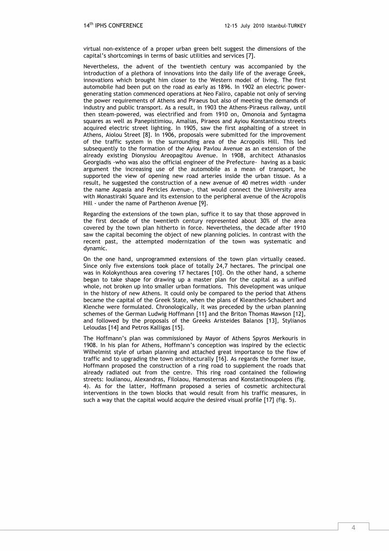
The Mawson‟s plan was commissioned by the Mayor of Athens Spyros Merkouris after a recommendation of Queen Sophia in 1914. Mawson submitted two plans for Athens. His final plan was presented in the form of an exhibition at Zappeion Hall on 17 February 1918 (fig. 6). The chief points were the following proposals [20]:
- Concentration of similar town functions in particular areas.
- Construction of housing estates for workers.
- Environmental upgrading of the area around the Acropolis.
14th IPHS CONFERENCE 12-15 July 2010 Istanbul-TURKEY
6
- Measures for dealing with traffic problems, such as the extension of Korai Street as far as Monastiraki Square.
- Creation of an economic body to implement and manage the proposals.
Figure 6: “New Athens”, The formation of central Athens, according the Mawson Plan, 1918 Source: Athens, Cultural Capital of Europe 1985, Athens in the 20th century, 1900-1940:
Athens Greek Capital, Athens: Ministry of Culture, p. 51 (in Greek).
The Mawson Plan faced criticism, accused of containing several weaknesses and simplifications concerning urban problems. However, as Mawson himself clarified, his suggestions had not reached yet their final form at that stage, but they were indicative of the principals to be followed in the future development of the Greek Capital [21].
The proposals of Greek town planners, which came chronologically later than those of the non-Greeks, were clearly closer to the real problems facing Athens and the country‟s economic potential. In July 1917, Balanos proposed that the official town plan be extended to the districts of Kolonos, Sepolia, Kolokynthou and the Iera Odos. In the designs he drew up to illustrate his proposal, he had shown a clear preference for planning that aspired to realization of the “garden city idea”, systematically avoiding rectangular grids of streets and including generous areas of parkland [22]. In March 1918 and again in July 1921, Leloudas published proposals that covered the entire Athens basin. In other words, he dealt for the first time with the Athens-Piraeus axis and the surrounding neighbourhoods as a uniform planning entity, a fact which made his views particularly innovative [23]. Finally, in 1918 Kalligas submitted his own Plan for Athens [24].
This “plethora” of town plans for Athens in such a short time was accompanied by changes in organization matters concerning technical issues of Greece. Specifically, the Ministry of Transport was established in 1914 -the first ministry- with a clear technical orientation. It held seventh place in the government hierarchy, which comprised eight ministry. Its first minister was D.A. Diamantidis. The new ministry was effectively formed from responsibilities detached from the Ministry of the Interior [25]. The School of Architecture in the National Technical University of Athens opened in 1917 -the first architects graduated in 1921- and finally the Higher Technical Council was established in 1919, members of which were such technical personalities, as the following: Petros Kalligas, Kostas Kitsikis, Anastasios Orlandos, Ioannis Axelos and Ernest Hebrard.
This “reformation” atmosphere of the 1910s was followed by the dismal situation of the 1920s. A decade marked by the unfortunate results of the War between Turkey and Greece. The immediate need for housing the refugees led to a radical change of urban planning policy, which had started to develop a few years before. The new policy gave priority to quickly shelter the newcomers, instead of making middle-long term town plans.
It is characteristic of the above development, that during the whole Inter-War period only two town planning proposals were submitted for Athens, one by Petros Kalligas in 1924, which actually was the continuation of his 1918 proposal, and the other by the General Directorate of Technical Services of the Municipality of Athens in 1935, signed by Mayor K. Kotzias and the Director of Technical Services E. Krimpas. Furthermore, two contributions were submitted, the first by Spilios
URBAN TRANSFORMATION: CONTROVERSIES, CONTRASTS and CHALLENGES
7
Agapitos in 1928, under the title The City (in Greek), and the second by Stylianos Leloudas in 1929, under the title The Greater Athens (in Greek).
A GENERAL OUTLINE OF ISTANBUL (THE OLD CONSTANTINOPLE)
CITY HISTORY
The old City within the walls was built on the right-hand cove of the narrow gulf of the Golden Horn, on an irregular triangular cape, the mouth of which faced in a westerly direction, with the Propontis, or Sea of Marmara, to the south, the tip of Galata to the north and the Bosphorus Strait, which divides the two continents, to the east. Continuous inhabitation of this section exceeds fifteen centuries, with the uninterrupted presence of the different ethnicities that composed the mosaic of two global empires, the predominant group being the Muslim one. At the end of the eighteenth century, the north coast of the Golden Horn -symbolised by the Genoese tower of Galata- was a wasteland dominated by cemeteries belonging to all the faiths. In less than fifty years, this area had become the most heavily-populated part of the capital, with much construction work going on. It became the “West End of the European colony, the city of elegance and pleasure”. Foreign architects, such as the Fossati brothers, d' Aronco, Vallaury, Mongeri and many others transformed this picture. Taksim Square was created by demolishing the barracks and expanding Pera to the north, i.e. in the direction of the neighbourhood of Pangaltı, where the district around Kurtuluş evolved from being the neighbourhood of the workers at the Imperial naval yards at Kasımpaşa, to the area where the middle classes of all the minorities settled. And the region of Galata continues to play a leading role in the economic life of Istanbul, thanks to the extension of the port in the 1890s and the location of industrial activities in the area between the two bridges that link the banks of the Golden Horn.
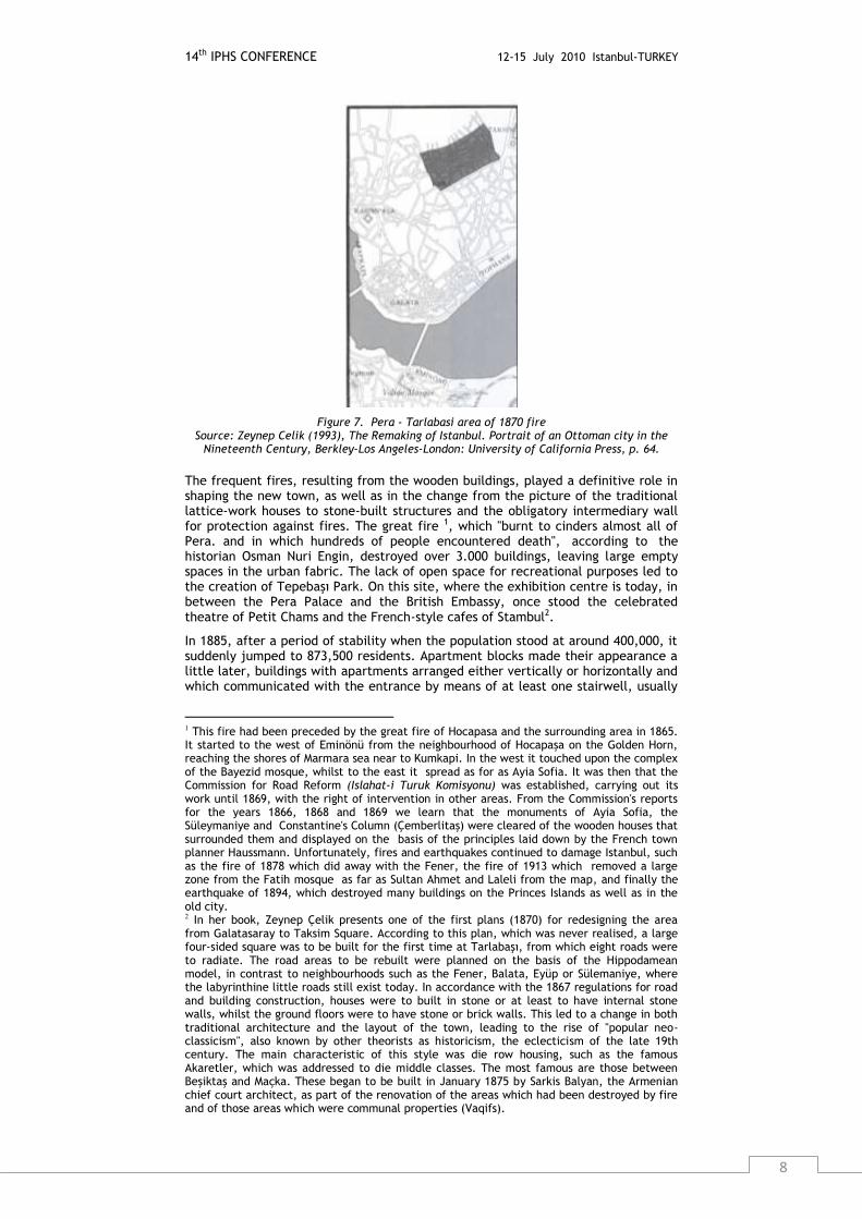
The transfer of the palace in 1856 from the Topkapi in the old part of the city to the Dolmabahce on the banks of the Bosphorus -a work by Garabet and Nikogos of the distinguished Balyan family of Armenian architects- was important enough in its symbolism alone. This was accompanied a year later by the reform of local government. In 1857, Constantinople was divided into 14 self-governing districts, something like the regiones of the Byzantine Empire. The difference here was that the system followed the French model of arrondissements. The biggest of them was the 6th district, which included the areas of Pera and Galata as far as Yıldız, site of Abdulhamid II's summer palace. Among the responsibilities of the local authorities, we can mention the issuing of licences for building roads, the management of markets and health services, land registry and public sanitation. The building which housed the 6th district of Pera was built in 1879-1883 by the Italian architect Barborini when the Englishman Edward Blacque was mayor. Of course, just like the earlier examples of Paris and Vienna, the walls of Galata had been demolished prior to the creation of Şişhane Square, after the fire of 1870 (fig. 7).
14th IPHS CONFERENCE 12-15 July 2010 Istanbul-TURKEY
8
Figure 7. Pera - Tarlabasi area of 1870 fire Source: Zeynep Celik (1993), The Remaking of Istanbul. Portrait of an Ottoman city in the
Nineteenth Century, Berkley-Los Angeles-London: University of California Press, p. 64.
The frequent fires, resulting from the wooden buildings, played a definitive role in shaping the new town, as well as in the change from the picture of the traditional lattice-work houses to stone-built structures and the obligatory intermediary wall for protection against fires. The great fire 1, which "burnt to cinders almost all of Pera. and in which hundreds of people encountered death", according to the historian Osman Nuri Engin, destroyed over 3.000 buildings, leaving large empty spaces in the urban fabric. The lack of open space for recreational purposes led to the creation of Tepebaşı Park. On this site, where the exhibition centre is today, in between the Pera Palace and the British Embassy, once stood the celebrated theatre of Petit Chams and the French-style cafes of Stambul2.
In 1885, after a period of stability when the population stood at around 400,000, it suddenly jumped to 873,500 residents. Apartment blocks made their appearance a little later, buildings with apartments arranged either vertically or horizontally and which communicated with the entrance by means of at least one stairwell, usually
1 This fire had been preceded by the great fire of Hocapasa and the surrounding area in 1865. It started to the west of Eminönü from the neighbourhood of Hocapaşa on the Golden Horn, reaching the shores of Marmara sea near to Kumkapi. In the west it touched upon the complex of the Bayezid mosque, whilst to the east it spread as for as Ayia Sofia. It was then that the Commission for Road Reform (Islahat-i Turuk Komisyonu) was established, carrying out its work until 1869, with the right of intervention in other areas. From the Commission's reports for the years 1866, 1868 and 1869 we learn that the monuments of Ayia Sofia, the Süleymaniye and Constantine's Column (Çemberlitaş) were cleared of the wooden houses that surrounded them and displayed on the basis of the principles laid down by the French town planner Haussmann. Unfortunately, fires and earthquakes continued to damage Istanbul, such as the fire of 1878 which did away with the Fener, the fire of 1913 which removed a large zone from the Fatih mosque as far as Sultan Ahmet and Laleli from the map, and finally the earthquake of 1894, which destroyed many buildings on the Princes Islands as well as in the old city. 2 In her book, Zeynep Çelik presents one of the first plans (1870) for redesigning the area from Galatasaray to Taksim Square. According to this plan, which was never realised, a large four-sided square was to be built for the first time at Tarlabaşı, from which eight roads were to radiate. The road areas to be rebuilt were planned on the basis of the Hippodamean model, in contrast to neighbourhoods such as the Fener, Balata, Eyüp or Sülemaniye, where the labyrinthine little roads still exist today. In accordance with the 1867 regulations for road and building construction, houses were to built in stone or at least to have internal stone walls, whilst the ground floors were to have stone or brick walls. This led to a change in both traditional architecture and the layout of the town, leading to the rise of "popular neo-classicism", also known by other theorists as historicism, the eclecticism of the late 19th century. The main characteristic of this style was die row housing, such as the famous Akaretler, which was addressed to die middle classes. The most famous are those between Beşiktaş and Maçka. These began to be built in January 1875 by Sarkis Balyan, the Armenian chief court architect, as part of the renovation of the areas which had been destroyed by fire and of those areas which were communal properties (Vaqifs).
URBAN TRANSFORMATION: CONTROVERSIES, CONTRASTS and CHALLENGES
9
in the centre of the ground plan, and lit with the help of a light well through the roof of the building. These buildings were provided with utilities such as water, gas, electricity and later telephones, and also with auxiliary areas that were quite new to the then traditional, predominantly rural, architectural style: a bathroom, kitchen (with or without fireplace), servants room, store room3. They determined a new way of life that was made acceptable as something "Western", oriented towards the wealthy middle and higher income groups of the minorities and foreign residents. A variation on this theme can be seen in the celebrated buildings with arcades on the ground floor, such as the Afrika Pasajı4 which united two parallel Pera roads (Büyük and Küçük Parmakkapı), and contained sixty apartments. Multi-storey buildings with arcades on their ground floors were more often designed for offices or workshops. Examples of these along the Grand Rue de Pera were the arcades of Rumeli, Anatolia, Syria, etc.
The widening and straightening of the roads, the construction of a sewage system and of other kinds of infrastructure (clean water, natural gas and telephone), presaged the coming of the Western way of life to the heart of the East. Although, the horse drawn tram was introduced in Istanbul in the 1860s, the electric tram operated in 1914. Meanwhile, the first car appeared in 1895 and the general use of it began after 1910. The empty spaces within the old walls of the city, where there had previously been small holdings and vegetable gardens, now began to be built upon. "It is the great city at the moment of its transformation, the product of old cities now shedding their swaddling-clothes, of new constructions that were built only yesterday and of others which are still being built. Everything is topsy-turvy. The signs of great construction work can be seen all over, with tunnelled mountains, hewn hills, demolished suburbs, great roads planned, a boundless pile of ruins and rubble from the fires scattered all over the ground that is being tortured by the people" said an Italian journalist Edmondo d' Amicis, who visited the City at decade of 1870. It is quite clear that these pertinent observations are still valid today5.
To return to the mid-nineteenth century, we can observe a significant change in the structure and landscape of Constantinople since the period of the conquest, apart from the regular fires. This was the increasing influence of the Western way of life on the built environment in an area where the greatest proportion of the Turkish Muslim ruling class, military and bureaucrats lived. A movement of the population to the coasts of the Bosphorus and also to the area above Dolmabahçe and Yıldız (Maçka, Nişantaşı, Pangaltı, Şişli) can be observed. The same holds for the coastal zone on the Asian side from Kadıköy (Chalcedon) as far as Bostanci. Small chalets, summer houses constructed on the sea shore (the famous yalı), country villas and retreats and cottages with gardens were built in all architectural styles, but mainly art nouveau and rustic. The railway line was extended, facilitating the settlement of privileged dwellers in the suburbs, the fashionable districts of Bakırköy (former Makrochori), Yeşilköy (former Aya Stefanos), and the baths of Floria (Florya) on the European coast of Propontis (Sea of Marmara). The cosmopolitan image of Constantinople was complemented by the summer houses of foreign inhabitants on the Princes Islands, which were a match for the Cote d'Azur or the spa towns of Switzerland and Germany.
The basic difference with Europe was that this image was a reflection of the indebtedness of the state, the court in particular, to the bankers of Galata. As regards the flourishing of businesses and credit banks, it must be emphasised that this was not the result of a large domestic accumulation of capital, but was
3 The first apartment block to be built in Pera was that of Seferoglou in 1882. 4 Of interest is the information provided by the 1920 register of inhabitants, according to which the Afrika Pasajı housed 34 Greek families, eleven Levantine, seven Armenian, three Jewish and two Muslim families. 5 The map drawn by A.D. Mordman, most likely in the 1890s, indicates the walls which were demolished along the coast of the Propontis and the Golden Horn and shows the railway line as terminating at Sirkeci Station. This building had been designed by the German professor Jasmund (1889) and is characterised by the basic design principles of the orientalist architecture of north Africa. The architect most likely wished to symbolise the terminal point of the Orient Express with the "classical" Ottoman order, in harmony with the aspect of the city at the time. The Haydarpaşa (1909) station on the railway to Baghdad does not appear on the map. This was a work of the German architects Helmet Cuno and Otto Ritter, with allusions to the design of neo-Renaissance style Central European towers.

14th IPHS CONFERENCE 12-15 July 2010 Istanbul-TURKEY
10
primarily due to a high level of borrowing from abroad, a consequence of the great demand for capital to support the substantial needs of the Ottoman state6.
THE TWENTIETH CENTURY’S TOWN PLANNING EVOLUTIONS OF ISTANBUL
At the beginning of the twentieth century, certain grandiose proposals for creating three squares to improve the Old City began to be heard. In 1902, during the reign of Abdulhamid II, the chief inspector of the Architectural Section of the Municipality of Paris, Joseph Antoine Bouvard, was invited over to suggest ways of creating central areas along French prototypes (fig. 8). We can thus observe the districts of the Hippodrome, the At Meydani (Hippodrome) (fig. 9) and the area around the monuments of Ayia Sofia and the Sultan Ahmed mosque being "cleared" of the surrounding buildings. The second major intervention was planned for Bayezid Square (fig. 10), where the University of Istanbul and the mosque of the same name now stand. The third proposal was that for the new Bridge of Galata (fig. 11) and that for Valide Sultan Square in Eminonu area (1902). Financial straits and the reaction of the public, who viewed the Sultan's efforts at westernisation with some reservations, did not permit anything more than the creation of an artificial lake. The proposal of the French engineer Arnodin is also worth mentioning.
In March 1900, he presented, for the first time in the history of the city, a transport system and town plan which would unite the banks of the Bosphorus with two suspension bridges and create a regional line for the railway company Companie International de Chemin de Fer de Bosphore (fig. 12). This proposal suggested bridging the coasts for the passage of the railway at two points: the edge of Sarayburnu with the opposite coast of Üsküdar (former Scutari) and Rumeli Hisar with Kandili. The second bridge, known as the Fatih, was built at this latter point almost a century later, although without railway tracks. The proposal foresaw the positioning of encased double piers in the sea every 130 metres. At the crown of each, a shrine would be constructed, built in the Cairo Mameluke mosque style. The bridges were called Hamidiye, and they symbolised the political and religious power of the Caliph of the Muslims, Sultan Abdulhamid II. The decade between 1900-1910 was the era of the "first national architecture", and the architect Kemalletin created apartment blocks and public buildings with Ottoman motifs and with a stylistic morphology that included references to the mosques of the classical era. The "neo-Ottoman" architectural order was born (fig. 13).
6 The Italian traveller Edmondo d' Amicis wonderfully portrays the contrasts and social conflicts that had begun to pervade the area: "Galata is the city of Constantinople. Almost all the roads are narrow and winding, each having its wine stores, patisseries, barbers, butchers, Greek and Armenian coffee houses, retail stores, workshops and shacks. Everything is murky, damp, muddy, slimy, like the lower-class neighbourhoods of London. Almost all the trade of Constantinople comes through this suburb. The stock exchange is here, the customs house, the branches of Austrian Lloyd, the French ferry boat companies, churches, hospitals, monasteries, warehouses. An underground railway connects Galata with Pera. If turbans and fezzes were not to be seen on the streets, one would not think that one was in the East".

URBAN TRANSFORMATION: CONTROVERSIES, CONTRASTS and CHALLENGES
11
Figure 8. Bouvard‟s three proposals for the Hippodrome (At Meydani), Beyazit Square and Valide sultan Square (Eminonu)
Source: Celik, Zeynep (1984), “Bouvard‟s Boulevards: Beaux-Arts Planning in Istanbul”, JSAH XLIII (December), p. 355.
Figure 9. At Meydani, proposal of Joseph Antoine Bouvard (1902 Source: Celik (1993), op. cit., back-cover.
Figure 10. Bayezid Square, proposal of Joseph Antoine Bouvard (1902) Source: Celik (1993), op. cit., front-page.

14th IPHS CONFERENCE 12-15 July 2010 Istanbul-TURKEY
12
Figure 11. New Galata Bridge, proposal of Joseph Antoine Bouvard (detail), (1902) Source: Celik (1984), op. cit., p. 350.
Figure 12. F. Arnaudin proposal of ring roads for Istanbul (1900) Source: Istanbul journal.
Figure 13. 4th Vakif Han (Office building) in Eminonu by architect Kemalletin Bey, founder of neo-Ottoman architectural style.
Source: E. Yenal (2001), Bir Kent: Istanbul, 101 Yapi (A City: Istanbul, 101 Buildings), Istanbul: YKY, p. 95.
Yet if, as the celebrated architect and university professor Sedat Hakkı Eldem writes, until the middle of the 19th century the traditional style of vernacular architecture based on a wooden frame and balconies (şahnisin) was practised by Greek and Armenian architects, known as "kalfas," the subsequent opening up to the West and extreme mimicry did away with such methods that had been handed down from the past. The architecture, which had lost all notion of individual contribution and had reached the level which we today know as "anonymous", turned to affectation and a mannered search for singularity. The attitude of the architects also changed, and they turned to innovation and experimentation, aiming to break away from the old, established principles. Slowly but surely, these
URBAN TRANSFORMATION: CONTROVERSIES, CONTRASTS and CHALLENGES
13
attempts disrupted the old professions and obliterated the guilds. This was a necessary price to pay for modernization. From this point on, mass and organized education and the participation of the elders in communal affairs were to define the development of the field. And, as has been shrewdly observed, "Architecture is not the expression of a society but of those in power who run if".
Istanbul today, with its population of 15 million, plays a significant geo-strategic role in the Balkan Peninsula, influencing the link between the countries of the Black Sea and the wider Mediterranean. Even though around a century ago its population barely exceeded one million7, the city played a more important political role as the capital of an empire and as a religious centre for the largest religions of the Middle East. The era of great disturbances and ethnic conflicts resulted in the concentration of Muslim refugee populations after the Balkan Wars.
7 According to the historian Kemal Karpat, who processed the data from the 1881/2-1893 census.
14th IPHS CONFERENCE 12-15 July 2010 Istanbul-TURKEY
14
CONCLUSIONS
Concluding, one should summarise the following. The common point, which contributed to the similarity between urban policies in Athens and Istanbul at the beginning of the twentieth century -even for a short period- could be explained in the terms of adοpting parallel ideological perspectives, that of modernization of the urban environment in the central districts of the two capital cities by both neighbour central or local governments. The so called policy of "westernization" changed many things in Athens and Istanbul in urban terms. However, it should be stressed that, that phase of capitalism in Europe and even more in the East, either concerning the Kingdom of Greece or the Ottoman Empire, did not induce the dramatic changes of modern capitalism. This influence was superficial since it was imported and not a result of internal proceedings. Therefore it was short-lived.
The import of "western" models in Greece by Hofmann and Mawson coincided with the neoclassic morphology and ideology, which were also the coping-stone of the upcoming -progressive at the time- bourgeois class. A neoclassic style, based on eclecticism, was created in architecture but also in urban planning for central city districts. At the same time, Istanbul went through a season of relatively big changes for its scale -after the Tanzimat-, and the invasion of European "innovators", like Bouvard, who provided the central city area large scale projects, based on eclectic ideas and neo-Ottoman aesthetic aspects regarding the architecture of the new buildings.
The same town planning procedures which were implemented had as an outcome the similarities met in Athens and Istanbul at the beginning of the twentieth century. As a final conclusion, one should stress that the urban interventions in the two cities had as a base the international town planning evolutions at that period which led to analogous choices, while the demonstration of differences was accomplished through aesthetic elements mainly in civic architecture.