Embed Size (px)
Citation preview
PANGANI DISTRICT COUNCIL
Decentralized Minor Permitting Procedure for Small Scale Mariculture Activities for Pangani District
Prepared by: District Executive Director
P.O Box 89 PANGANI
OCTOBER 2013
This publication is available electronically on the Coastal Resources Center’s website at http://www.crc.uri.edu. For more information contact: Coastal Resources Center, University of Rhode Island, Narragansett Bay Campus, South Ferry Road, Narragansett, Rhode Island 02882, USA. Visit: www.crc.uri.edu. Tel: (401) 874-6224; Fax: (401) 874-6920.
Citation: Mutatini, A. (2013). Decentralized Minor Permitting Procedure for Small Scale Mariculture activities for Bagamoyo District. Coastal Resources Center, Graduate School of Oceanography, University of Rhode Island, Narragansett, RI, 65 pp.
Disclaimer: This report is made possible by the generous support of the American people through the United States Agency for International Development (USAID). The contents are the responsibility of the Coastal Resources Center at the University of Rhode Island as part of the USAID/Pwani Project. Cooperative Agreement No. 621-A-00-10-00012-00.
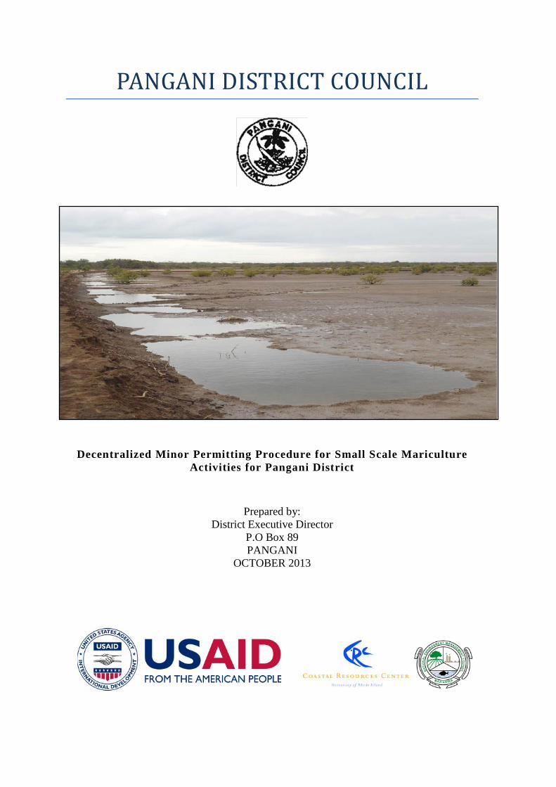
Cover Photo: Potential site for small scale mariculture in Pangani District.
Photo Credit: Alieth Mutatina
Table of Contents
PART I ...................................................................................................................................1
1.1 EXECUTIVE SUMMARY ............................................................................................. 1
1.2 ENDORSEMENT FROM PANGANI DISTRICT ......................................................... 2
1.3 ABBREVIATIONS ......................................................................................................... 3
1.4 DEFINITION OF TERMS .............................................................................................. 4
1.5 INTRODUCTION ........................................................................................................... 7
1.6. OBJECTIVES ................................................................................................................. 8
1.6.1 Main objectives ......................................................................................................... 8
1.6.2 Specific Objective ..................................................................................................... 8
1.7 Pangani District Mariculture Policy and Strategies ......................................................... 9
1.7.1. Strategy 1. Ensuring capacity building among extension officers for sustainable development of mariculture in the District ........................................................................ 9
1.7.2. Strategy 2. Create monitoring and control mechanism for mariculture practices at district level. ................................................................................................................... 9
(a) Allowable methods of cultivation ............................................................................... 9
(b) Eligible projects for Minor Permits issued by the District .......................................... 9
(c) Limits on the location of small scale operations ....................................................... 10
(d) Limit on the size of mariculture operations .............................................................. 10
(e) Species suitable for cultivation .................................................................................. 10
1.7.3 Strategy 3. Combat/Prevent coastal environmental degradation results from mariculture trials and practices. ....................................................................................... 10
(a) Awareness raising on mariculture opportunities and low environmental impacts mariculture practices ....................................................................................................... 10
(b) Projects that cause significant environmental impacts cannot receive a Minor Permit .............................................................................................................................. 10
(c) Existing operations will be regularized ..................................................................... 11
(d) Maximum extent of pond operations in an estuary ................................................... 11
1.7.4 Strategy 4. District Bylaw for implementation of mariculture permit procedures . 11
1.7.5 Strategy 5. Ownership for applied land use of Zone IV Mangrove areas ............... 12
1.7.6. Strategy 6. Enhanced coastal communities livelihood through improved mariculture practices ........................................................................................................ 12
(a) Incentives for the development of small scale mariculture projects ......................... 12
(b) Mariculture sites with conflicting interests ............................................................... 12
(c) Best business and pond management practices ......................................................... 12
PART II ................................................................................................................................13
2.0 MARICULTURE PRACTICES AND ZONING IN PANGANI DISTRICT ............... 13
2.1. Current situation on mariculture practices .................................................................... 13
2.2. Problems facing mariculture development in Pangani District .................................... 13
2.3. Mariculture zoning, estuary profiling and seed scouting in Pangani District ............... 14
2.3.1. Buyuni Suitable sites for mariculture activities ..................................................... 14
2.3.2. Mkwaja Suitable sites for mariculture activities .................................................... 16
2.3.3. Mikocheni Suitable sites for mariculture activities ............................................... 18
2.3.4. Sange Suitable sites for mariculture activities ....................................................... 21
2.3.5. Kipumbwi Suitable sites for mariculture activities ................................................ 22
2.3.6. Mikinguni Suitable sites for mariculture activities ................................................ 23
2.3.7. Stahabu Suitable sites for mariculture activities .................................................... 25
2.3.8. Ushongo Suitable sites for mariculture activities .................................................. 26
2.3.9. Bweni Suitable sites for mariculture activities ...................................................... 29
2.3.10. Mkwajuni Suitable sites for mariculture activities .............................................. 30
2.3.11. Pangani Magharibi Suitable sites for mariculture activities ................................ 31
2.3.12. Mwembeni Suitable sites for mariculture activities............................................. 32
2.3.13. Msaraza Suitable sites for mariculture activities ................................................. 33
2.3.14. KiguruSimba Suitable sites for mariculture activities ......................................... 35
2.4. Site Analysis Requirement Prior to Villages Issuing the Approval .............................. 36
PART III ..............................................................................................................................37
3.0 Mariculture Monitoring And Control In Pangani District .............................................37
3.1. Small Scale Mariculture Permitting Procedures ........................................................... 37
3.2. Application Procedures and District Review ................................................................ 37
3.3. Monitoring and evaluation ............................................................................................ 41
3.4. Spatial Database ............................................................................................................ 41
PART IV ANNEXES .........................................................................................................42
ANNEX 1: Area covered with salt flats by ward and by village ........................................ 42
ANNEX 2: Important Aspects to Be Considered During Project Screening ....................... 44
ANNEX 3(a): Application Form ......................................................................................... 46
ANNEX 3(b): Application Form at Village level ................................................................ 48
ANNEX 4: REGISTER FOR AQUA FARMERS .............................................................. 51
ANNEX 5: LOG BOOK FOR FISH FARM MANAGEMENT ......................................... 52
ANNEX 6: LOG BOOK FOR SEAWEED FARM MANAGEMENT ............................... 53
ANNEX 7: AQUACULTURE PRODUCTION DATA ..................................................... 54
ANNEX 8: SMALL SCALE MARICULTURE PROJECT PERMIT ................................ 55
ANNEX 9: CERTIFICATE OF APPROVAL FOR FISH OR AQUACULTURE* ESTABLISHMENT ............................................................................................................. 56
ANNEX 10: Routine monitoring of hatchery and grow-out farms ..................................... 57
ANNEX 11: Checklist for the Village Government Committee ......................................... 63
ANNEX 12: Checklist for the District Technical Team ...................................................... 65
ANNEX 13: Considerations in Site Selection and Operations ............................................ 69
1. Location ....................................................................................................................... 69
2. Water quantity and quality ........................................................................................... 69
3. Soil quality ................................................................................................................... 69
4. Tidal characteristics and ground elevation .................................................................. 70
5. Flood hazard................................................................................................................. 70
6. Climatic conditions ...................................................................................................... 71
7. Type and density of vegetation .................................................................................... 71
8. Fingerling availability .................................................................................................. 71
9. Supportive entrepreneurial Environment ..................................................................... 71
10. Marketing ................................................................................................................... 71
1
PART I
1.1 EXECUTIVE SUMMARY The coast is the place where the land meets the Ocean. It is an area that is endowed with abundant and unique resources that need to be protected and conserved in a sustainable manner. The National Integrated Coastal Management strategy provides a framework under the National Environment Policy that links sectors at the District level and leads those sectors in a cooperative way in order to bring sustainable development. Coastal resources are under huge pressure that is caused by people being highly dependent on them for food and other basic needs, thus increasing the likely failure of these resources to support our future generations. Recently, different large economic activities are being located in coastal areas and more will follow. The establishment of a zoning and management plan for small-scale pond mariculture in Pangani district addresses one of the economic activities that are to provide development in our coastal communities.
It is for this reason that Pangani district has decided to use an Integrated Coastal Management (ICM) strategy to introduce a zoning system that will establish permitting procedures for estuary and mangrove areas for pond mariculture. This system addresses the expanding number of requests for milkfish pond developments and will ensure that there is no significant environmental impacts from individual farms as well as potential cumulative impacts due to increase in number of ponds to particular area. Pangani is creating a model ordinance relevant to other areas of the nation and is a way to scale up responsible milkfish farming in the vicinity of existing pond sites.
The District authorities will now regulate eligible projects for minor permits, set limits on the location, size of small scale mariculture operations and determine suitable species for cultivation. Establishment of new ponds and normalizing existing pond aims to encourage well running pond operations that produce the intended products which are highly resistant to damage and disease. The ponds in Pangani will not cause problems to others. The new procedures remove any uncertainties in decision making, which benefits the district as well as the permit holders in the nine wards where fish pond development will be permitted.
The planning and design of this document involved a range of stakeholders from village to district levels. The process involved village government leaders, fishers, mariculture farmers, salt producers and district experts in fields of natural resources and allied industries. The steps followed to prepare this document included identification and mapping of potential sites for mariculture activities along the coastline of Pangani Furthermore, this document contains guidelines for mariculture practices in Pangani district that form an important part of a master plan for the coast that will reduce conflicts in potential mariculture areas for the benefit of all coastal communities. It is anticipated that enhanced mariculture practices will contribute to economic growth of communities and hence play part in poverty reduction as stipulated in MKUKUTA, MILLENIUM 2015, Dira ya Taifa ya Maendeleo 2025 and Kilimo Kwanza Policy.
In conclusion, I would like to offer my gratitude to the United States Agency for International Development (USAID), the Coastal Resources Centre of the University of Rhode Island (CRC/URI), the Tanzania Coastal Management Partnership (TCMP), and Government officials of Pangani District Council. I also would like to thank all the Pangani stakeholders who participated and contributed to the development of this document and who generously supported the process.
2
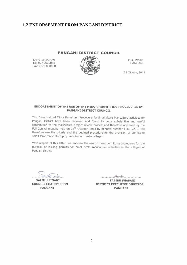
1.2 ENDORSEMENT FROM PANGANI DISTRICT
3
1.3 ACRONYMS
CMT Council Technical Team
DED District Executive Director
DTT - District Technical Team
EIA Environmental Impact Assessment
GPS Global Positioning System
ICMWG Integrated Coastal Management Working Group
NEMC National Environmental Management Council
TCMP Tanzania Coastal Management Partnership
TIB Tanzania Investment Bank
TIC Tanzania Investment Centre
USAID United States Agency for International Development
WDC Ward Development Committee
VG Village Government
4
1.4 DEFINITION OF TERMS The following terms have a specific meaning within the context of these Guidelines:
Application fee –a fee that is required to be paid during the application for a mariculture site in a district
As-built or existing pond – an earthen pond already constructed to create an enclosure for culturing of fin fish or any marine organism
Council Management Team (CMT) - refers Councils’ Head of Departments of the Pangani District Council.
Council Technical Team (CTT) – refers to council heads of sections in the district representing their expertise, e.g. natural resource, fisheries, forestry, etc. during the evaluation of applications for aquaculture ponds.
Cultivation Method – The method applied to culture any aquatic organism.
Enforcement action – Any action aimed to curb illegal practice, e.g. construction of a pond in mangrove areas
Estuary – the aquatic region where marine and fresh water meet (river mouth meets with ocean) mostly the area is rich in prawn fishing
Existing pond – A pond that are already built and stocked with fingerlings
Exotic Species – Non-native species that are imported or introduced from outside the area in question
Extensive Cultivation – Cultivation of aquatic organism whereby the organisms totally depend on natural habitat for food, i.e. no manure, no fertilizer, no external feeding etc.
Global Positioning System (GPS) A technique involving a hand-held electronic device that records the geographic position of the user which should be used to locate, record and map mariculture ponds and related infrastructure for the spatial data base.
Intensive Cultivation – Cultivation of aquatic organism where they totally depend on man-made feed and husbandry
Large scale aquaculture – means a system having a water surface area of five hectares or more for breeding or raising fish
Major Permit – Permit that involves large scale (greater than 10 ha) mariculture operations and has to go to NEMC for EIA.
Mangrove Zone IV – The zone that is permitted for development of various activities according to the Mangrove Management Plan, e.g. construction of fish ponds or salt pans, etc.
Mariculture operation – Is the keeping or culture of aquatic organism, e.g. in ponds, cages, etc.
5
Minor Permit – The permit involves small scale (less than 10 ha) mariculture operation which does not need to go NEMC for EIA.
Native species - Species that found naturally in the area of concern.
One Stop Review – Is the review of a mariculture project whereby everything is done in one multi-sectoral office: application, review and permitting.
Operation fee – A fee that is charged on a periodic basis during the operational lifetime of a licensed pond.
Permit Application – Request for permission to undertake a mariculture operation in a potential site through completing a written form with pertinent information about the proposed project that is sufficiently complete to allow authorities to review and evaluate it.
Permit Approval – The written decision containing approval or permission for the requested application
Permit Monitoring Data Base: the data file that contains all data collected about aquaculture project including application for permission, decisions, enforcement and environmental monitoring for each application.
Permit Rejection – Termination of permit/permit refusal.
Permit Renewal – This is the application for a permit at the end of the previous permit.
Pond – Small body of standing water used for the culture of aquatic organism.
Salt Flats – A base area inundated by seawater often used for salt pans.
Semi intensive aquaculture – means the practice whereby fish are kept under confinement and biological, physical and chemical parameters are partially controlled
Semi-Intensive Cultivation – Cultivation of aquatic organism where the feeding process partially depends on natural habitat and the other part might be introduced or man-made feeds or nutrients.
Significant environmental impact: a substantial, or potentially substantial, adverse change in any of the conditions within the area affected by the project, including but not limited to land, air, water, minerals, flora, fauna, ambient noise, and objects of historic or aesthetic significance.
Site – Location/place chosen for pond construction.
Site inspection – A physical inspection of the proposed or built pond site by one or more members of the District Technical Team for verification for the accuracy of information in the permit application and to check for suitability of the area where culture of marine organism is expected to take place.
Small-scale aquaculture-means the practice of breeding or raising of aquatic organisms within an area not exceeding one hectare
Spatial Data- Base – Data base that contains information about the location, extent and nature of culture.

6
Stocking species – species that are stocked in a pond to grow.
Use or Access Rights - specific permission given to the applicant for a license to utilize the land area for the duration of the aquaculture project, in the form of a lease, title, grant, permit, concession or other legally binding document that protects the holder from loss of access for a prescribed period of time.
Village Development Committee – A Village committee comprising members from that particular village responsible for addressing development issues of the village
Zoning Scheme – separation of certain zones to reduce user conflicts depicted by a written or visual representation of boundaries, allowable uses and restrictions.
7
1.5 INTRODUCTION Mariculture in Tanzania is in an early stage, but is steady growing. The number of fish ponds (milk fish, mullet, tilapia, and prawn) in coastal districts is more than 100. With some 50,000 hectares of salt flats in the country, the potential for fish and prawn farming expansion is high and growth is likely to continue, contributing to food security, income generation and employment in coastal communities.
The development of pond mariculture in Tanzania faces a number of challenges which include uncertain legal ownership for sites responsible for aquaculture, the need for reliable source of quality seeds, the limited number of qualified extension officers, high initial investment cost and fish feeds. There is high potential for developing mariculture practices so that coastal communities may benefit economically, however not every individual will have enough capital to build the infrastructure for the larger, more difficult sites. With increasing decline of capture fisheries, the need for testing the viability of small scale, less capital-intensive mariculture in suitable locations to help meet protein requirements through fish and shellfish farming remains paramount. In this regard Pangani district finds it worth to improve small scale mariculture practices by zoning of potential sites and issuing permits for areas currently practising mariculture along its coastline.
The need for mariculture monitoring and control in Pangani is not a new idea. It can be traced back to the early 1990s when the Pangani Mariculture Working Group suggested various priority areas required to be improved to enhance mariculture in the district among which was setting of criteria for pond culture and approvals. Subsequently, much of similar ideas have been taken on board to develop mariculture permitting guidelines included in this document termed as Pangani District Small-Scale Mariculture Zoning and minor Permitting Procedure. The goal of the Pangani District Small-Scale Mariculture Zoning and minor Permitting Procedure is to carry out a functional, practical, coordinated and decentralized permitting system in Pangani District for small-scale coastal mariculture projects (particularly for milkfish, mullet, tilapia and prawn farming and any other form of raising marine species in captivity). This is an attempt to establish good Integrated Coastal Management (ICM) practice that utilizes spatial information for decision making.
Most small-scale mariculture activities can be broadly divided into three types:
• Earthen pond culture
• Open water culture systems operated in the intertidal and sub intertidal waters (mollusc culture in shallow salt water areas, seaweed farming in coastal seas, pen and cage culture in sea water bodies, and culture of giant clams, sponges and corals in or near coral reefs)
• Hatcheries for finfish and shellfish including prawns and crabs
The Pangani District mariculture zoning and permitting procedures document is aimed at providing a way to monitor and control all activities related to rearing marine species along the coastline of Pangani. Such activities includes but not limited to seaweed, pearl oyster, milk fish and prawn farming, crab fattening and production of related fingerlings.
Theoretically, mariculture practices can be conducted on agricultural land, salt flats and undesirable land. These habitats are typically part of marine ecosystem and normally under village, ward district or private ownership. Hence on implementation of this document a
8
fish farmer will be required to obtain permit from the Mangrove reserve Authority or place to be used for mariculture from respective sector. Where applicable, developer will need to obtain license from District Fisheries officer, if it is a big project NEMC and Aquaculture Division should be involved in EIA and Licence giving respectively
The experience shows in some cases mariculture operators could potentially use a particular habitat site in ways that are not prohibited legally, but which could still cause negative impacts to the neighbouring environments. Zoning as a management tool used in conjunction with a simplified and decentralized permitting system can help avoid this dilemma and regulate use in areas appropriate for mariculture.
These procedures aimed to develop a zoning and management plan for small-scale mariculture in Pangani district that can be used for sustainable development of mariculture as a pilot for other districts in Tanzania. It also aimed to provide a practical permitting procedure for interested small scale mariculture investors in Pangani district. This will provide sustainable mariculture development and management with low environmental impacts.
1.6. OBJECTIVES
1.6.1 Main objectives The objectives of the Pangani District Small-Scale Mariculture Zoning and its Minor Permitting Procedure are to put a mechanism in place which would provide smooth monitoring and control of mariculture practices in Pangani District. This objective aimed to locate potential sites for mariculture activities to ease the provision of permits for sustainable small scale mariculture activities for improving livelihoods of the coastal communities. It is anticipated that through this process the district will be able to:
• Characterize and map potential mariculture areas in Pangani District so as to provide orderly development
• Establish a low cost, efficient, decentralized permitting procedure for small-scale pond mariculture, reducing the potential for cumulative impacts and providing a model for other coastal Districts
• Promote responsible, controlled growth of small-scale earthen pond culture in a way that is environmentally sustainable and does not exceed the carrying capacity of the estuaries or degrade mangrove ecosystems
• Document and monitor mariculture operations to enable enforcement of compliance with policies and to provide information to allow for adjusting policies in the future
• Advance environmentally and economically sound land use planning in relation to resource allocation and population in coastal communities
1.6.2 Specific Objective This document is specifically aimed to address key issues as related to mariculture development which includes;
9
• Establish an efficient, low cost and decentralized permitting procedure for sustainable small scale mariculture systems
• Reducing the potential for cumulative impacts resulting from exceeded carrying capacity of fish ponds in the estuaries or degrade the mangrove ecosystems through the enforcement of compliance with polices and to provide information to allow for adjusting polices in the future.
• Create a mechanism through which all mariculture systems in the district are registered and monitored
1.7 Pangani District Mariculture Policy and Strategies The Pangani mariculture policy aims at ensuring that practices and development of the industry is in sustainable manner in terms of environment conservation and contribution to socio-economic of the communities involved. The policy states that, “Mariculture practices are sustainably carried out in terms of environment and contribution to socio-economic and improve livelihood of coastal communities in Pangani district”.
This policy is based on the following strategies:
1.7.1. Strategy 1. Ensuring capacity building among extension officers In the course of developing mariculture in a sustainable manner, the district will ensure that technical capacity for the extension officer is built to enable provision of extension services to farmers. This may entails facilitating the participation in short term or long term mariculture trainings.
Capacity building of extensionists will cater for the demand of existing and new applicants investing in mariculture activities. In addition to that be able to identify and be updated on new opportunities for the small scale mariculture project owners and be prepared to contain outbreak of fish disease in the ponds.
1.7.2. Strategy 2. Create monitoring and control mechanism
(a) Allowable methods of cultivation The District will only issue permits for extensive and semi-intensive forms of cultivation. Proposals for intensive culture of species will be rejected outright and applicants directed to the attention of the National Environmental Management Council, Aquaculture Division or TIC.
(b) Eligible projects for Minor Permits issued by the District The following existing ponds and newly constructed ponds are generally eligible for a Minor Permit if they meet the following requirements:
• Involve a total of less than 10 hectares
• Do not utilize exotic species
• Do not involve intensive forms of cultivation technology
• Have clear title or tenancy over the site
10
• Are acceptable to the village and ward where it is located
• Will not cause significant environmental impacts
• Are located in designated suitable areas
(c) Limits on the location of small scale operations It is the policy of Pangani District to limit the areas where small scale mariculture can occur to those locations which are behind mangrove forest, corresponding to areas designated as suitable in technical studies and encompassing portions of agricultural land, salt flats, undesirable land and areas designated as Mangrove Zone IV.
Pangani District has an estimated area of 572.0 (ha) where mariculture activities might be permissible. Based on field analysis these salt flats are distributed in the nine coastal wards, namely Mkwaja, Kipumbwi, Mikinguni, Mwera, West Pangani, Ubangaa, Madanga and Bushiri.
(d) Limit on the size of mariculture operations It is the policy of Pangani District to limit the size of a small scale mariculture individual operation to no more than 5 hectares. Proposals larger than this will be rejected outright and the applicant directed to apply for a Major Permit from the National Environmental Management Council or Tanzania Investment Centre (TIC) and Aquaculture Division.
(e) Species suitable for cultivation The District will only issue permits for the cultivation of native species of fish and shellfish. Proposals for the cultivation of exotic, non-native species will be rejected outright and applicants directed to the attention of the National Environmental Management Council and Aquaculture Division.
1.7.3 Strategy 3. Combat/prevent coastal environmental degradation Mariculture is an emerging coastal livelihood opportunity that can contribute to poverty alleviation to coastal residents. However care has to be taken avoiding negative environment impact that may result due to poor practices. This strategy aim at reducing environmental degradation and promoting best practices and will be implemented though the following actions:-
(a) Awareness raising on mariculture opportunities and low environmental impacts mariculture practices
• The district council will raise awareness to all relevant stakeholders on establishment of mariculture projects and their operations. This will include the available opportunities and the know how to operate such projects with very minimal environmental impacts such that they do not affect other ecosystems in their vicinity.
(b) Projects that cause significant environmental impacts cannot receive a Minor Permit
• Permits will not be issued for a proposal with a high likelihood of causing significant environmental impact to the estuary and land where it is located.
11
• Pond operations should not cause harm to endangered species and protected areas.
• Pond operations should not interfere with adjacent uses in any way that cannot be mitigated or compensated.
(c) Existing operations will be regularized Existing ponds will be required to submit information documenting the nature of their operation so that permits can be regularized to remove any uncertainties for the benefit of the district as well as the permit holder. The District will work with each pond operator to identify and rectify any issues of inconformity with this ordinance.
(d) Maximum extent of pond operations in an estuary Pangani has 5 estuaries namely Pangani river, Msangazi, Sima, Kama and Mligaji river estuaries. These are distributed in nine wards where fish ponds development will be permitted (an estuary consists of the coastal area where fresh water from the land mixes with sea water, usually semi-enclosed by a barrier beach or spit). To protect environmental quality in these areas, it is the policy of Pangani District to issue its minor permits for mariculture related pond construction to an area that is no more than 5 ha of each area of suitable sites. The intent is to avoid the accumulation of impacts that could damage the environment of these areas as well as interference with other activities in the area.
1.7.4 Strategy 4. District Bylaw for implementation of mariculture permit procedures
To sustain mariculture activities and safeguard environmental quality, the district is putting in place mechanism for the development, and enforcement of the Bylaws that are necessary in all villages where suitable sites are located. In this regards the following practices are not allowed
• Carrying out small scale mariculture activities without legal permit from the Village Government and District Executive Director.
• Carrying out mariculture activities outside the area that has been zoned by the village council.
• Carrying out activities that contravenes with the Mangrove Management Plan.
• Clearing and uprooting any of the plants in the area
• Bush firing near the sites
• Carrying out any other activities than those indicated in the permit
• Animal grazing
• Conduct any act which will degrade or bring negative impacts to the environment
• Illegal fish harvest from ponds
Anyone found guilty of any act listed above, that person(s) will be fined not more than TZS 50,000/- together with equal value of the damage caused.
12
1.7.5 Strategy 5. Ownership for applied land use of Zone IV Mangrove areas
Most of the identified suitable sites and which the village Government have zoned are located in Zone IV as stipulated in the Mangrove Management Plan. According to Mangroves Management Plan, Zone IV is allowed to be developed and therefore establishment of mariculture activities through constructing fish ponds is permitted.
However in case an applicant wants to apply for Certificate of Right of Occupancy for the land has to consult the land and Forestry department.
For whoever wishes to establish such kind of activities will have to apply as per District Minor mariculture permit procedures and/or as Forestry guidelines.
Mariculture farms/ponds have to be operated in a sustainable way such that the local communities benefits from such activities in terms of poverty reduction (economically) as well as reduce pressure from wild stocks.
1.7.6. Strategy 6. Enhanced coastal communities livelihood through improved mariculture practices
(a) Incentives for the development of small scale mariculture projects To minimize conflicts and ecosystem impacts, it is the policy of Pangani District that earthen pond mariculture that meets the standards and criteria described below be encouraged for the economic well-being of its communities. The procedures for obtaining Minor Permits issued by the District shall not require the applicants to bear an undone burden in meeting standards of proof or in the lengthy and costly proceedings. The District will have 30 business days from the time of accepting an application to issuing the permit.
(b) Mariculture sites with conflicting interests All sites of which were identified to be suitable for establishment of small scale mariculture activities will be used as described under this particular Minor Permit Procedures for small scale mariculture activities. Exceptions to this statement are sites which due to legal boundaries, their location falls under more than one village and hence posing potential conflicts in the procedure of issuing permit. No permit will be issued on such sites until the disputing villages reaches consensus.
(c) Best business and pond management practices The District of Pangani seeks to encourage the establishment of well-run pond operations that produce the intended products, are resistant to damage and disease and does not cause such problems to others, and are managed in ways that generate the revenue necessary to cover costs and allow for maintenance of the operations. Applicants are encouraged to seek technical assistance on the design and operation of their facilities as well as adopt best business management practices. The district will ensure the mariculture extension officers visits small scale farmers/fish pond owners more often to provide technical assistance.
13
PART II
2.0 MARICULTURE PRACTICES AND ZONING
2.1. Current situation on mariculture practices Available records suggest that aquaculture was first introduced in Tanzania in late 1940s. It is being estimated that the industry produces about 3000 tons of fish annually, from more than 8000 ponds scattered all over the country. Most fish farmers in the country prefer to produce Tilapia species especially the Oreochromis niloticus though there are many other species that could be farmed successfully.
Introduction of seaweed farming was established in 1994 in Pangani Distict. This was after one Fisheries Officer took a short visit to Zanzibar and see the development of the seaweed also discussed and convinced developers to start seaweed farming in Pangani District. Lastly in agreement was met with Zanzibar Agro-seaweed Company (ZASCO) to start farming at Ushongo village, commercially seaweed farming started in January 1995 by two varieties of algae Eucheuma spinosum and Eucheuma cottonii followed by fish farming, prawn farming and crab fattening.
The most successful case of mariculture development in Pangani District is seaweed farming of the red algae, Euchema spinosum and Euchema cottonii conducted in Ushongo, Kipumbwi, Sange, Mikocheni and Mkwaja villages with some trials in Buyuni and northern coast. Some parts have also tried pond fish farming without success due to limited skills in terms of pond construction and general pond management as well as availability of viable fingerlings.
2.2. Problems facing mariculture development in Pangani District Mariculture development in Pangani faces a number of problems which partly have contributed to under-development of the industry. These include:
• Unavailability of source of good seedlings or fish fingerlings
• Lack of knowledge and skills required for production of quality seeds and fish feeds,
• Presence of predators such as frogs, snakes and tortoise
• Illegal fishing practices such as beach seine and poisoning which were observed along the coast and confirmed to destroy seaweed farms
• Seaweed diseases
• Low quality of mariculture products
• Inadequate extension services to monitor and evaluate mariculture activities
• Inadequate water supply especially due to weather and climate change impacts which changes water compositions (limnological factors)
• Inconsistency of mariculture products to the existing markets
14
Despite these setbacks, coastal communities extensively practice seaweed farming though low prices is another challenge to farmers, which needs to be addressed along with improvement of processing and handling techniques as well as adding value to mariculture products. Adding to that, there are interests of fish pond constructions as milk fish species have seen to be of priority among the members of the coastal communities to the extent that the interested groups are showing up and seek technical assistance from the district.
2.3. Mariculture zoning, estuary profiling and seed scouting in Pangani District During mariculture suitable sites analyses for the coast of Pangani, most of the sites which were surveyed were mapped through taking coordinates with GPS and they were qualified to be right candidates for mariculture activities. The main idea of mapping these sites is to determine how much land has been used for mariculture activities, carrying capacity of the total land as well as to set proper procedures for establishment such kind of activities. Apart from available land, seeds/fingerlings availability for stocking is crucial when considering establishment of mariculture farms. Potential sites for fish fingerlings collection were identified whereby during rainy seasons fingerlings are readily available in plenty and thus the establishment of mariculture farms will have to follow the seasonality.
Similar to zoning of suitable mariculture sites, there was a need to identify and locate all sources of water/entry points to all specific salt flats along the coast and to be layered with mariculture maps for consistency of documentation of the coast regarding mariculture activities. This is due to the fact that, these estuaries/creeks are the ones which determines the sustainability of mariculture activities for the specific selected areas especially for small scale mariculture projects.
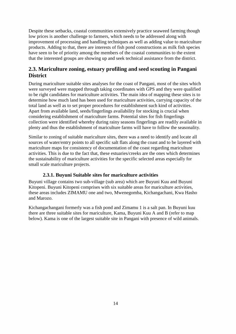
2.3.1. Buyuni Suitable sites for mariculture activities Buyuni village contains two sub-village (sub area) which are Buyuni Kuu and Buyuni Kitopeni. Buyuni Kitopeni comprises with six suitable areas for mariculture activities, these areas includes ZIMAMU one and two, Mwenegomba, Kichangachani, Kwa Hasho and Marozo.
Kichangachangani formerly was a fish pond and Zimamu 1 is a salt pan. In Buyuni kuu there are three suitable sites for mariculture, Kama, Buyuni Kuu A and B (refer to map below). Kama is one of the largest suitable site in Pangani with presence of wild animals.
15
Plate 1: Representatives of Suitable sites for mariculture activities in Buyuni Village
16
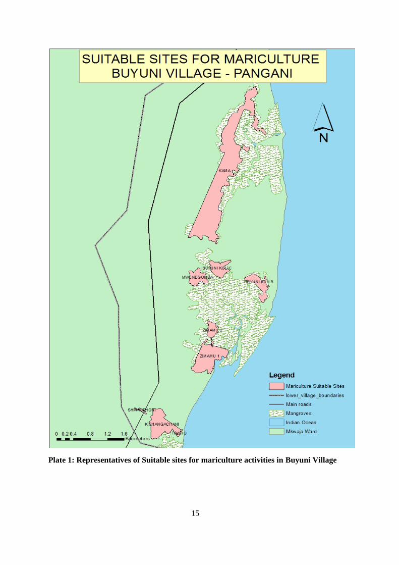
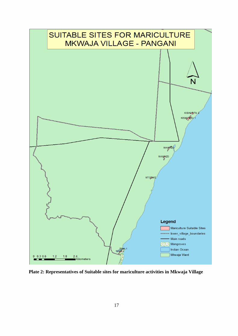
2.3.2. Mkwaja Suitable sites for mariculture activities Mkwaja village has six areas which are suitable for mariculture, these includes Sima One and Two, Mto Ake, Mawazo and Kisiki Mtu one and two.
Sima one and two characterised with loam soil and presence of grasses and some few patches of mangroves. Mawazo is very close to the village and formerly was a fishing pond.
17
Plate 2: Representatives of Suitable sites for mariculture activities in Mkwaja Village

18
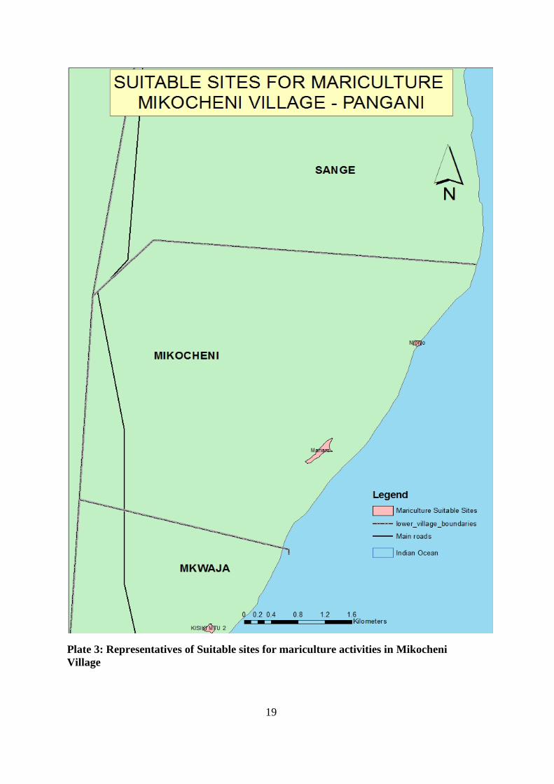
2.3.3. Mikocheni Suitable sites for mariculture activities In Mikocheni, two areas, locally known as Mariam and Njonjo, were deemed suitable for small-scale mariculture activities. Mariam is a relatively large salt flat bordered by abundant mangroves and characterized by a periodic inflow of seawater. Elephant tracks in the loam-type soil indicate that mariculture development may induce conflict between villager and elephant populations. The Njonjo site is smaller in size but located in closer proximity to the shoreline. It is characterized by a lower topography and a highly clay-type soil. Even in a period of low-tide, the site contains a basin of seawater with a depth of approximately 1m, indicating that conditions are highly favourable for small-scale mariculture activities.
19
Plate 3: Representatives of Suitable sites for mariculture activities in Mikocheni Village

20
21
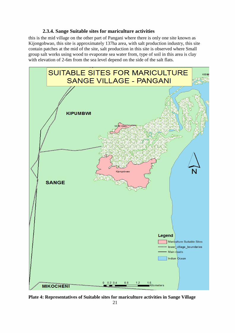
2.3.4. Sange Suitable sites for mariculture activities this is the mid village on the other part of Pangani where there is only one site known as Kijongobwao, this site is approximately 137ha area, with salt production industry, this site contain patches at the mid of the site, salt production in this site is observed where Small group salt works using wood to evaporate sea water from, type of soil in this area is clay with elevation of 2-6m from the sea level depend on the side of the salt flats.
Plate 4: Representatives of Suitable sites for mariculture activities in Sange Village
22
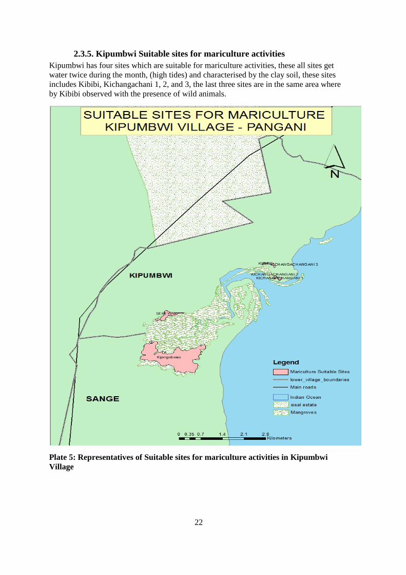
2.3.5. Kipumbwi Suitable sites for mariculture activities Kipumbwi has four sites which are suitable for mariculture activities, these all sites get water twice during the month, (high tides) and characterised by the clay soil, these sites includes Kibibi, Kichangachani 1, 2, and 3, the last three sites are in the same area where by Kibibi observed with the presence of wild animals.
Plate 5: Representatives of Suitable sites for mariculture activities in Kipumbwi Village
23
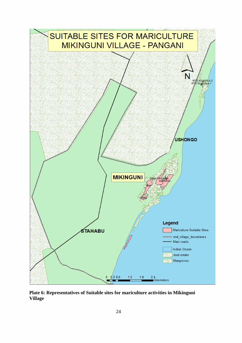
2.3.6. Mikinguni Suitable sites for mariculture activities One area, locally known as Mtego wa Simba, was deemed suitable for small-scale mariculture activities. Mtego wa Simba is a large trans-boundary salt flat in that the southern portion falls within the Stahabu village’s area of ownership. Once boundaries are clearly established, Mikinguni and Stahabu will have to establish agreements in order to eliminate conflict and manage their respective mariculture developments effectively. Mtego wa Simba presently contains several salt pans for salt production indicating adequate water quality for mariculture activities. However, Mtego wa Simba is located at a relatively high elevation which may represent a concern in terms of water quantity. It may not be possible to maintain a water depth of 0.8m inside the pond without the installation of costly water pumping infrastructure.
24
Plate 6: Representatives of Suitable sites for mariculture activities in Mikinguni Village

25
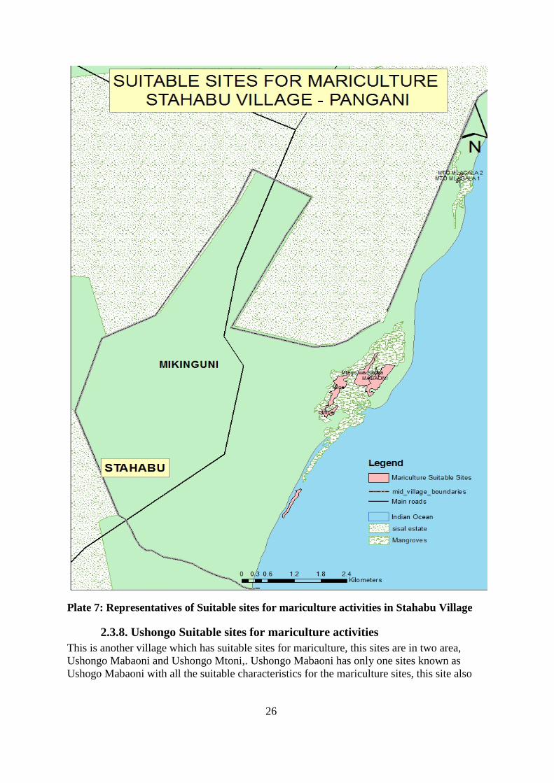
2.3.7. Stahabu Suitable sites for mariculture activities In this village there are two sites seen which are Stahabu Pwani and Mloe, Stahabu Pwani has loam type of soil with presence of grasses, in this area water get in during every high tides, presence of fish (milk fish) were told. At Mloe there is scattered mangrove with clay type of soil, in this area there are salt pans presence
26
Plate 7: Representatives of Suitable sites for mariculture activities in Stahabu Village
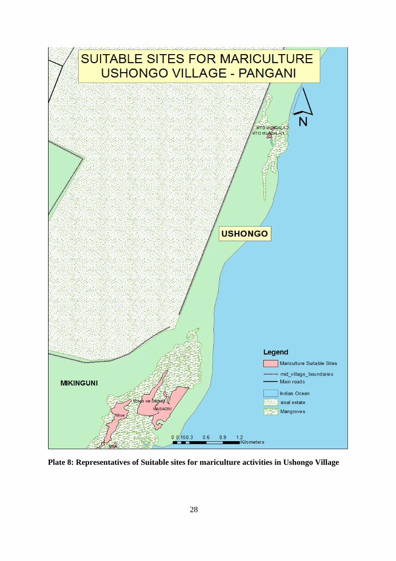
2.3.8. Ushongo Suitable sites for mariculture activities This is another village which has suitable sites for mariculture, this sites are in two area, Ushongo Mabaoni and Ushongo Mtoni,. Ushongo Mabaoni has only one sites known as Ushogo Mabaoni with all the suitable characteristics for the mariculture sites, this site also

27
have patches of trees in between this sites have clay soil at the north and loam soil at the south, in this site there were observed unsuccessful salt pans.
Ushongo Mtoni has two sites which are Mto Mlagala 1 and Mto mlagala 2. These two sites all meet the characteristics of suitable sites for mariculture, where by the former site has unsuccessful milk fish pond and the latter is a salt pan.
28
Plate 8: Representatives of Suitable sites for mariculture activities in Ushongo Village
29
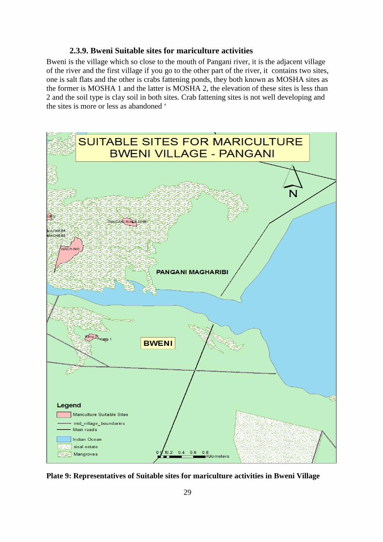
2.3.9. Bweni Suitable sites for mariculture activities Bweni is the village which so close to the mouth of Pangani river, it is the adjacent village of the river and the first village if you go to the other part of the river, it contains two sites, one is salt flats and the other is crabs fattening ponds, they both known as MOSHA sites as the former is MOSHA 1 and the latter is MOSHA 2, the elevation of these sites is less than 2 and the soil type is clay soil in both sites. Crab fattening sites is not well developing and the sites is more or less as abandoned ‘
Plate 9: Representatives of Suitable sites for mariculture activities in Bweni Village
30
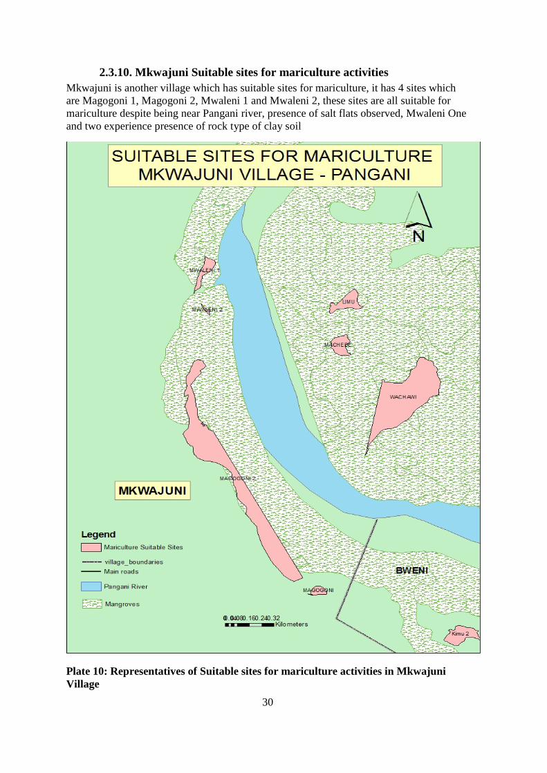
2.3.10. Mkwajuni Suitable sites for mariculture activities Mkwajuni is another village which has suitable sites for mariculture, it has 4 sites which are Magogoni 1, Magogoni 2, Mwaleni 1 and Mwaleni 2, these sites are all suitable for mariculture despite being near Pangani river, presence of salt flats observed, Mwaleni One and two experience presence of rock type of clay soil
Plate 10: Representatives of Suitable sites for mariculture activities in Mkwajuni Village
31
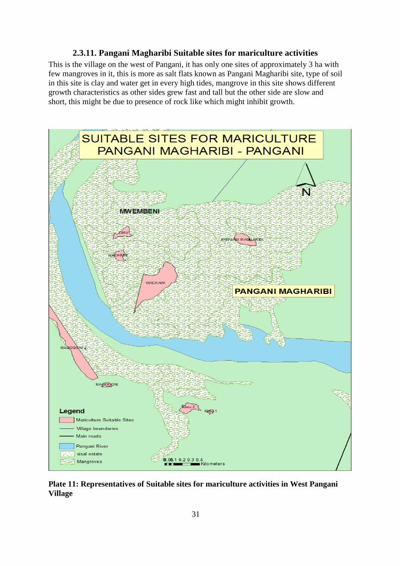
2.3.11. Pangani Magharibi Suitable sites for mariculture activities This is the village on the west of Pangani, it has only one sites of approximately 3 ha with few mangroves in it, this is more as salt flats known as Pangani Magharibi site, type of soil in this site is clay and water get in every high tides, mangrove in this site shows different growth characteristics as other sides grew fast and tall but the other side are slow and short, this might be due to presence of rock like which might inhibit growth.
Plate 11: Representatives of Suitable sites for mariculture activities in West Pangani Village
32
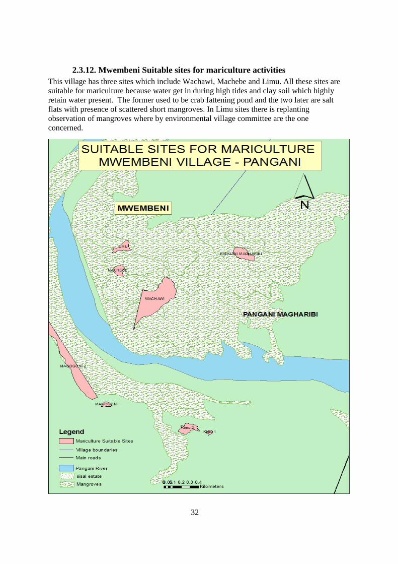
2.3.12. Mwembeni Suitable sites for mariculture activities This village has three sites which include Wachawi, Machebe and Limu. All these sites are suitable for mariculture because water get in during high tides and clay soil which highly retain water present. The former used to be crab fattening pond and the two later are salt flats with presence of scattered short mangroves. In Limu sites there is replanting observation of mangroves where by environmental village committee are the one concerned.
33
Plate 12: Representatives of Suitable sites for mariculture activities in Mwembeni Village
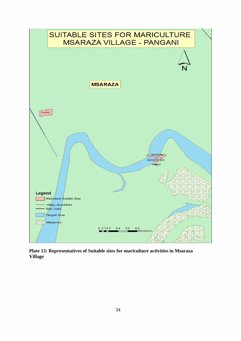
2.3.13. Msaraza Suitable sites for mariculture activities This is another village which is at the north Pangani adjacent to the river, it has 4sites known as RABANI, Mzee Muhuni sites, MATAKANI and KIBU. The first two sites are qualified with clay soil and get water in every high tides, even though presence of coconut tree and other vegetation were observed in a low growth and bad health probably due to presence of salt water. These sites are more close to the river.
The other two sites are more far from the river but water get in twice in every months (high tides) and presence of grasses were observed, this might be due to also presence of fresh water from the river. These are qualified sites for mariculture as salt water also observed and low concentration might lead water exchange not to be frequently.
34
Plate 13: Representatives of Suitable sites for mariculture activities in Msaraza Village
35
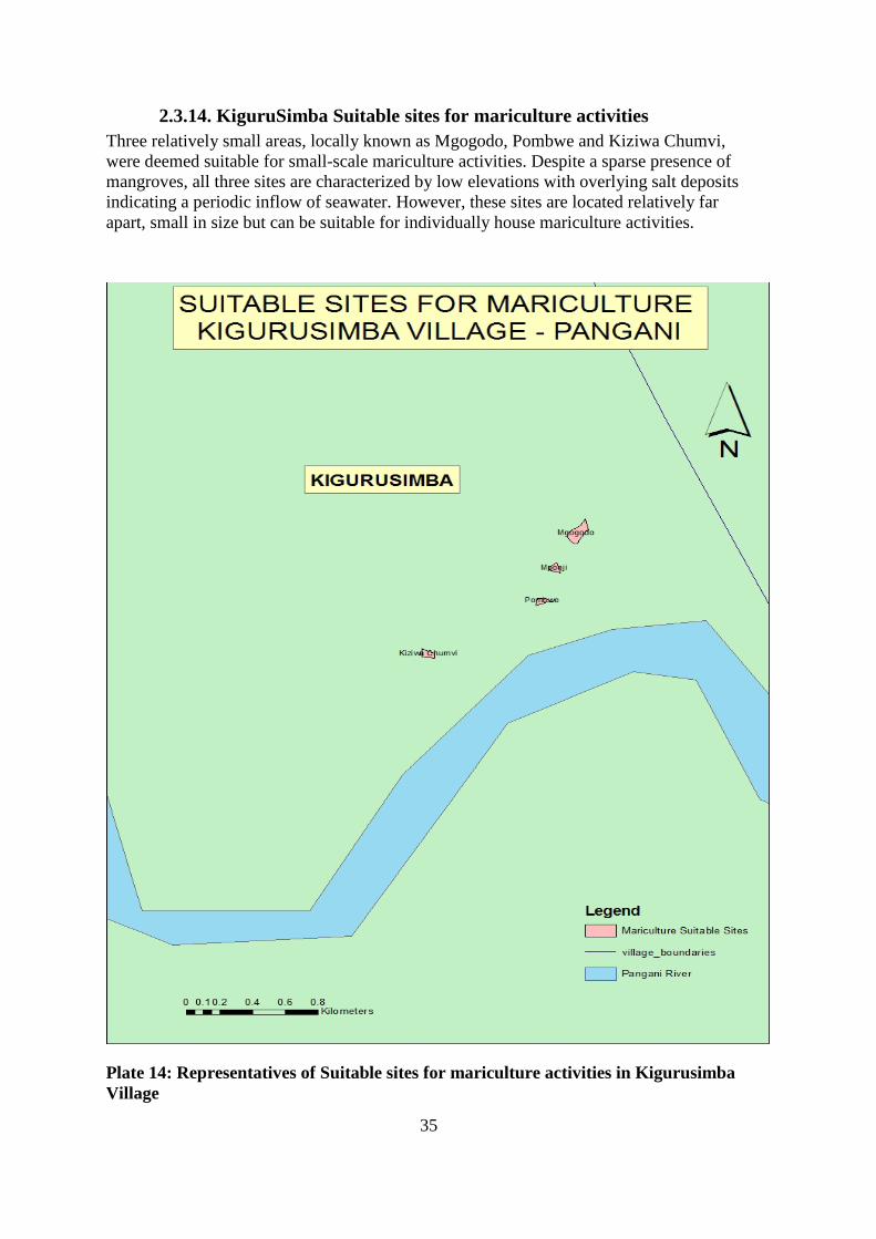
2.3.14. KiguruSimba Suitable sites for mariculture activities Three relatively small areas, locally known as Mgogodo, Pombwe and Kiziwa Chumvi, were deemed suitable for small-scale mariculture activities. Despite a sparse presence of mangroves, all three sites are characterized by low elevations with overlying salt deposits indicating a periodic inflow of seawater. However, these sites are located relatively far apart, small in size but can be suitable for individually house mariculture activities.
Plate 14: Representatives of Suitable sites for mariculture activities in Kigurusimba Village
36
2.4. Site Analysis Requirement Prior to Villages Issuing the Approval Mariculture development depends very much on reliable source of sea water. Creating a profile for a specific area is essential to identify the current status, future needs and its potential for development. A water source here means all entry points from sea water through mangrove forests to land which beyond them that can get tidal water twice a month. These points are associated with human activities and thus can be affected anthropogenically basing on the nature of the communities around that area as well as change naturally due to climate change. The process of profiling the sites involved the surrounding coastal communities for them to understand the results and the use of the findings. Adding to that, by collecting all information for a profile for each specific estuaries and creeks will have an important benefit to Pangani District to update the coast as well as to ensure actions are appropriate and effective in the course of environmental and coastal resources conservation. On the other hand to understand the community to increasing awareness of its services, identify issues, problems and needs of such ecosystems. However, there are some areas which are in critical situation and thus they need recovery plans instead of mariculture activities establishments.
37
PART III
3.0 Mariculture Monitoring And Control In Pangani District
3.1. Small Scale Mariculture Permitting Procedures The permitting procedure for small-scale mariculture activities shall follow the procedures described below using the forms and instructions provided in the Annexes as indicated. The procedures are based upon those described in the Mariculture Investor’s Guide. However the Pangani procedure shall be simple, easy to use and especially suitable for use at the community level. The District does not take on the responsibility for directly helping individuals or groups acquire sites, initiate or manage mariculture businesses. Important considerations that persons interested in initiating small-scale pond culture should take into account regarding site selection and fish pond operations are listed in Annex 13.
A potential mariculture pond in an existing salt works or other pond structure will be provided with the quickest review, and will not be considered as a new operator in terms of the limits on cumulative development of mariculture in the estuary where the farm is located mentioned in Strategy 2(c). Therefore, the investor only needs to be registered and be listed in the village mariculture roster. However, the investor should fill in an application standard form provided and follow all necessary steps as shown on Figure 1 under section 3.2.
All other applicants are encouraged to consider carefully the size of the operation they ultimately wish to manage. This regulatory procedure is not intended to handle projects that do not conform to the basic requirements of eligibility described in Strategy 2(b). Applicants are discouraged from occupying the time of district authorities with requests that patently exceed this threshold. The District will exercise its right to reject such applications outright without detailed technical review or site visit.
For sustainable environmental and coastal resources use, establishment of any kind of Mariculture related projects should follow the Environment and Social management Framework (ESMF) and Resettlement of Policy Framework (RPF) as well as Environmental Impact Assessment (EIA) procedures should be followed.
Early steps for conducting EIA for any project is SCREENING through PRA which will results into grouping of various project groups (A,B,C) basing on the type and nature of the project itself. Type A projects are regarded ad large projects which for this case does not fall under these Permit Procedures and are required to undergo EIA procedures by NEMC. Types B and C are moderate and small scale projects which most of cases are implemented by local communities , these may or may not undergo EIA procedure depending on (i) Type (ii) size and (iii) sensitiveness of these specific projects. However, these projects (B and C) have to be screened (Annex 2).
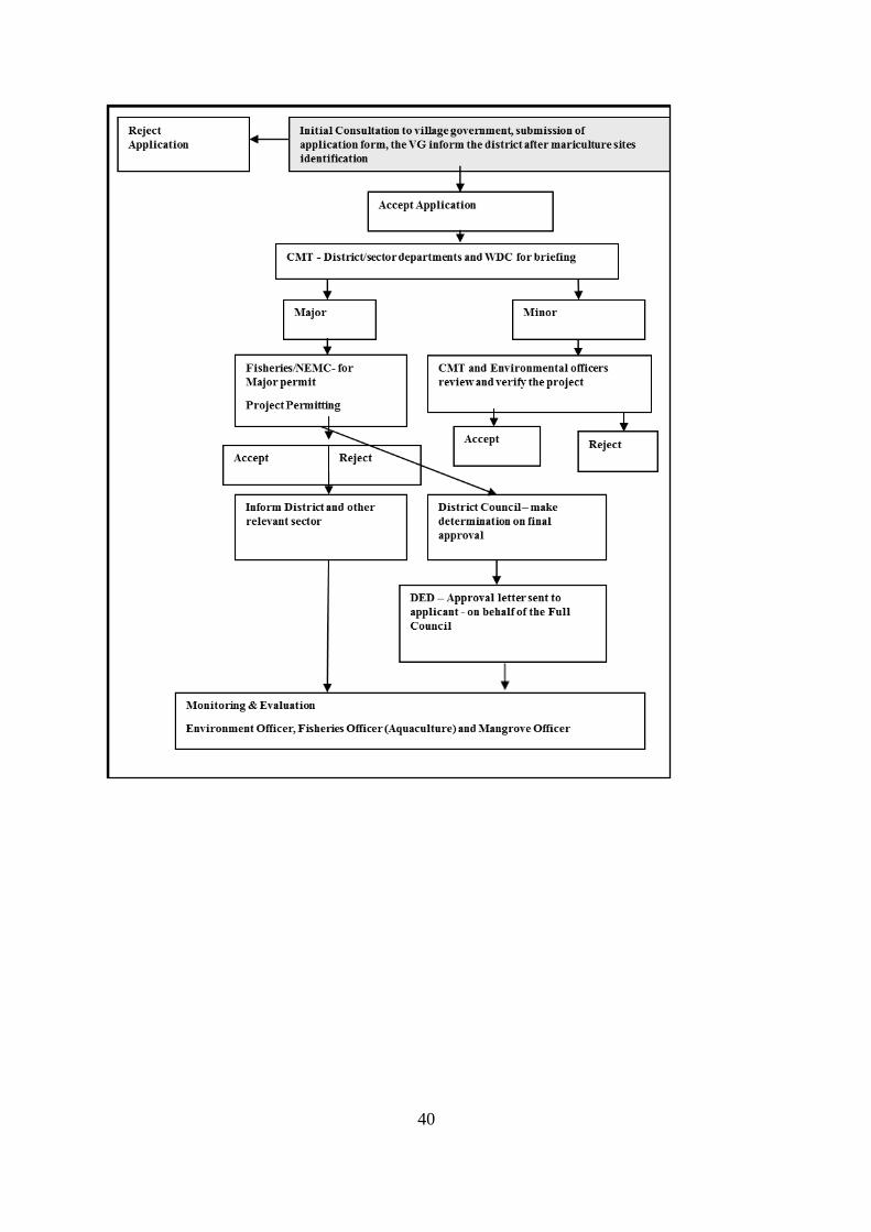
3.2. Application Procedures and District Review Anyone having an idea to start a mariculture operation shall initially send his application for obtaining permit through the following steps:
A duly filled in application form (Annex 3) shall be submitted to the village government with application fee of which stated under specific section in Bylaws in each village where
38
mariculture activities have to be established and including all the necessary attachments of land use permit, and 3 passport size photos.
If approved at the village level, the village government will send the application forms together with all the necessary attachments to the Council Management Team (CMT) for preliminary review.
The CMT will examine the following aspects of the proposal:
• Verify that the application is complete, including land permit (ownership or concession for the site from the Village, Ward or District)
• Determine if the project meets the thresholds for Minor Permit. If not, then reject, recommend revision or recommend submission to the NEMC Major Permit process.
• The thresholds for classifying an application as a Major Permit include the following:
• The project is greater than 10 hectares in size
• The applicant is not the party with title, ownership or concession for the site from the Village, Ward or District
• The project will generate significant environmental impacts through construction or operation, or is partly or wholly within a geographic area where aquaculture uses are prohibited
• The project involves intensive culture technology
• The project involves the cultivation of exotic species
If it is a minor operation, i.e. does not have significant impacts; then:
The CMT will conduct a field inspection of the proposed site. This should be done utilizing staff with appropriate technical expertise in collaboration with village government (VG) and a copy of the document submitted to Ward Development Committee (WDC)
The CMT will review the proposed project design to insure that the activities can in fact be accommodated at the site, that the applicant has the necessary legal and physical access to construct all of the required installations, and that no required technical aspect of the project has been left out of the application.
The CMT will confirm that the project falls within the areas predetermined as potentially suitable for aquaculture, is compatible with adjacent uses and is consistent with local development plans
The CMT will verify that the applicant has indicated where they will get the knowledge, financial resources and management ability necessary to carry out the project as proposed or revised.
The CMT will issue one of the following recommendation statements within 30 business days of receiving a properly completed application forms:
39
• Recommendation for rejection
• Recommendation for submission to NEMC as a major permit
• Acceptance conditioned on specified modifications to the application or conformity with additional conditions
• Outright acceptance
The CMT will submit the application with recommendations to the District Council for approval with a copy to the Ward Development Committee. The District Executive Director (DED) shall write to the applicant and inform about the decision (Annex 8) with a copy to Village government and provide information to the Aquaculture Division and NEMC for public record. The flow of the permit procedure is described (as Figure 1 below) while the District letter of approval will serve as evidence of a permit to operate the mariculture farm.
If the application is approved, the applicant must pay appropriate fees as described under District Bylaws on acquiring Certificate of Approval for Fish or Aquaculture Establishment (Annex 9)
40
41
Figure 1: District Small scale Mariculture Permitting procedure
3.3. Monitoring and evaluation Monitoring and evaluation of permitted operations is the responsibility of the District Office in particular ICM, environment, fisheries and forestry (mangrove) officers. Monitoring should determine if the terms on the project as permitted have been followed in order to avoid environmental impacts. In particular, it is important to monitor water which is discharged from the pond(s) in terms of quality and quantity. Water quality features of discharged waters for assessment include pH, salinity, specific density, and temperature. The capacity of the receiving water to dilute the discharge to acceptable levels should be considered.
3.4. Spatial Database The District office shall maintain a database on mariculture activities with the following information taken from the application form, DTT review and field inspections. Data fields may include the following:
• Name of owner and manager
• Precise location determined using GPS coordinates
• Source of water (name of river, stream, estuary, or open sea)
• Number of employees
• Design of pond(s)
• Date of construction
• Number of ponds and total pond area (hectares)
• Source of fingerlings for stocking (e.g. hatchery or capture from the sea/estuary.)
• Species stocked and stocking density
• Date of harvests and amount harvested
• Critical difficulties (e.g. permit approval; stocking; growth rate; pond construction; water supply; harvest; transport of harvested fish; sale of fish)
42
PART IV ANNEXES
ANNEX 1: Area covered with salt flats by ward and by village Locations presenting existing areas of mariculture operations
Ward Village Location Name HECTARES Status
Mkwaja
Buyuni
Kichangachangani 31.0 Mwenegomba 13.0 Hasho 1.0 Shirikishoni 1.0 Zimamu 1 38.0 SF Zimamu 2 9.0 BUyuni kuu A 1.0 BUyuni kuu B 14.0 BUyuni kuu C 14.0 Kama 159.0
Mkwaja
Sima 1 0.5 Sima 2 1.0 Kisiki mtu 1 15.0 Kisiki mtu 2 1.0 Mto ake 1.0 Mawazo 3.0
Mikocheni
Mariam kwa Dhaffa 4.0 Njonjo 1.0
Sange Kijongobwao 137.0
Kipumbwi Kipumbwi
Serewani 11.0 Kichangacahangani 1 1.0 Kichangacahangani 2 1.0 Kichangacahangani 3 1.0 Kibibi 1.0
Mikinguni
Mikinguni Mtego wa simba 14.0 Mloe 18.0
Stahabu Stahabu Pwani 5.0 Ushongo
Mabaoni 21.0 Mto Mlagala 1 1.0
Mto Mlagala 2 0.5
Bweni Kimu 1 0.5 Kimu 2 2.0
Mwera Mkwajuni
Magogoni 1 1.0 Magogoni 2 18.0 Mwaleni 1 0.5
Mwaleni 2 1.0 West Pangani
Pangani magharibi
Pangani magharibi 3.0
Ubangaa Mwembeni
Wachawi 14.0 Machebe 1.0 Limu 2.0
43
N.B:
FP represents Fish Pond
SF Salt flats
* Estimate of areas based upon GIS analysis of Mangrove Forest Maps published in 1990 by the Ministry of Lands, Natural Resources and Tourism, Forest and Beekeeping Division. All field surveys of existing and potential mariculture suitable were supervised by Mutatina Alieth. from TCMP in 2010 where GIS and maps analysis were conducted by Jumanne Mohamed from TCMP with technical backstops from Don Robadue from University of Rhode Island.
Madanga
Msaraza
Labani 0.5 Mzee Mhuni 1.0 Matakani 2.0 (No name) 4.0
Bushiri kigurusimba Mgogodo 1.0
Pombwe 0.5 Kiziwa chumvi 0.5 Mponji 0.5
TOTAL 572.0
44
ANNEX 2: Important Aspects to Be Considered During Project Screening
• Will the intended project contribute to environmental and resources destruction? Yes/No
Comments: ………………………………………………………………………………………………………………………………………………………………………………………………………………………………………………………………………………
• Will the intended project cause land, water or air pollution? Yes/No
Comments: ………………………………………………………………………………………………………………………………………………………………………………………………………………………………………………………………………………
• Will the intended project shift the community? Yes/No
Comments: ………………………………………………………………………………………………………………………………………………………………………………………………………………………………………………………………………………
• Will the intended project cause health problems? Yes/No
Comments: ………………………………………………………………………………………………………………………………………………………………………………………………………………………………………………………………………………
• Will the intended project contribute to policy changes; e.g. Water Policy? Yes/No
Comments: ………………………………………………………………………………………………………………………………………………………………………………………………………………………………………………………………………………
• Will the intended project affect local communities or individuals in the area which may cause more expenses in accessing available resources? Yes/No
45
Comments: ………………………………………………………………………………………………………………………………………………………………………………………………………………………………………………………………………………
• Will the intended project affect land title ownership within the proposed project area? Yes/No
Comments: ………………………………………………………………………………………………..
• Will the intended project cause conflicts due to negative impacts from the project after being implemented? Yes/No
Comments: ………………………………………………………………………………………………………………………………………………………………………………………………………………………………………………………………………………
• For ensuring sustainable resources use, it is crucial to avoid all types of projects which does not comply with environmental good practices.
• To control environmental pollution caused by the proposed project e.g. handling of wastes (waste management systems)
• Proper uses of pesticides/insecticides while considering:
o Correct type of the pesticides to apply
o Right quantities to be applied
o Observation of shelf lives of pesticide to be applied
o Transportation of specific pesticides (from one place to another) and their storage
o Proper clothing during application
o Follow instruction for application
o Hygiene for equipment to be used during application
o Disposal of used equipment after application
46
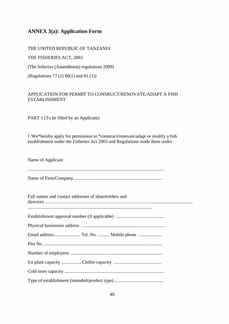
ANNEX 3(a): Application Form
THE UNITED REPUBLIC OF TANZANIA
THE FISHERIES ACT, 2003
(The fisheries (Amendment) regulations 2009)
(Regulations 77 (1) 80(1) and 81 (1))
APPLICATION FOR PERMIT TO CONSRUCT/RENOVATE/ADAPT A FISH ESTABLISHMENT
PART 1 (To be filled by an Applicant)
I /We*hereby apply for permission to *construct/renovate/adapt or modify a fish establishment under the Fisheries Act 2003 and Regulations made there under
Name of Applicant
......................................................................................................................
Name of Firm/Company.............................................................................
Full names and contact addresses of shareholders and directors ............................................................................................................................................................................................................................................
Establishment approval number (if applicable) ..........................................
Physical businesses address ........................................................................
Email address....................... Tel. No. .......... Mobile phone ....................
Plot No. ......................................................................................................
Number of employees ...............................................................................
Ice plant capacity ................. Chiller capacity .........................................
Cold store capacity ......................................................................................
Type of establishment (intended/product type) ..........................................
47
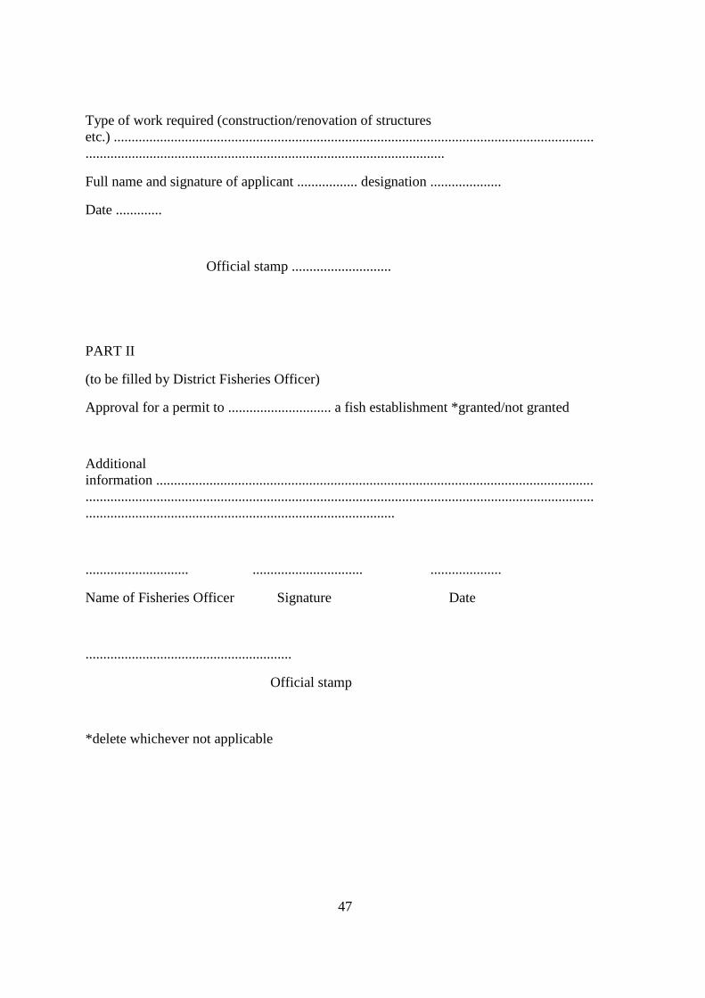
Type of work required (construction/renovation of structures etc.) ............................................................................................................................................................................................................................................
Full name and signature of applicant ................. designation ....................
Date .............
Official stamp ............................
PART II
(to be filled by District Fisheries Officer)
Approval for a permit to ............................. a fish establishment *granted/not granted
Additional information .................................................................................................................................................................................................................................................................................................................................................................
............................. ............................... ....................
Name of Fisheries Officer Signature Date
..........................................................
Official stamp
*delete whichever not applicable
48
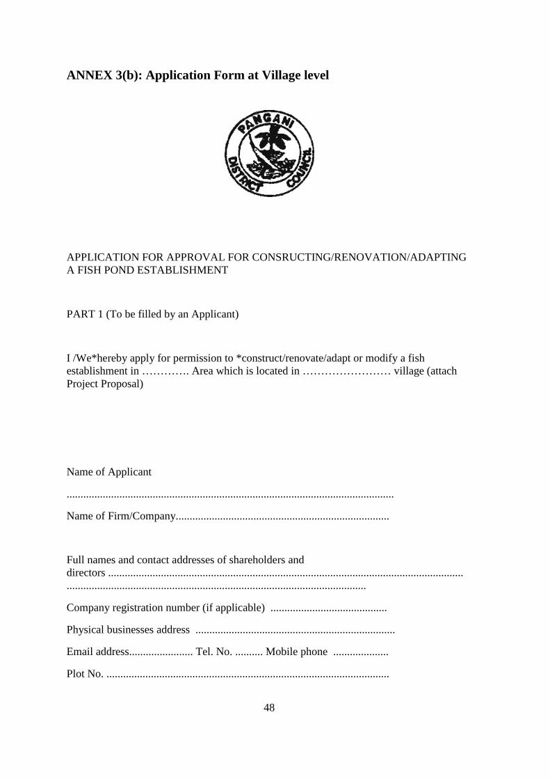
ANNEX 3(b): Application Form at Village level
APPLICATION FOR APPROVAL FOR CONSRUCTING/RENOVATION/ADAPTING A FISH POND ESTABLISHMENT
PART 1 (To be filled by an Applicant)
I /We*hereby apply for permission to *construct/renovate/adapt or modify a fish establishment in …………. Area which is located in …………………… village (attach Project Proposal)
Name of Applicant
......................................................................................................................
Name of Firm/Company.............................................................................
Full names and contact addresses of shareholders and directors ............................................................................................................................................................................................................................................
Company registration number (if applicable) ..........................................
Physical businesses address ........................................................................
Email address....................... Tel. No. .......... Mobile phone ....................
Plot No. ......................................................................................................
49
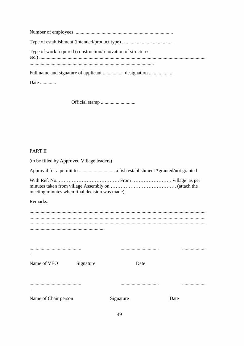
Number of employees ...............................................................................
Type of establishment (intended/product type) ..........................................
Type of work required (construction/renovation of structures etc.) ............................................................................................................................................................................................................................................
Full name and signature of applicant ................. designation ....................
Date .............
Official stamp ............................
PART II
(to be filled by Approved Village leaders)
Approval for a permit to ............................. a fish establishment *granted/not granted
With Ref. No. ………………………………. From …………………… village as per minutes taken from village Assembly on …………………………………. (attach the meeting minutes when final decision was made)
Remarks:
...............................................................................................................................................
...............................................................................................................................................
...............................................................................................................................................
.............................................................
.......................................... ............................... ...................
.
Name of VEO Signature Date
.......................................... ............................... ...................
.
Name of Chair person Signature Date
50
..........................................................
Official stamp
PART III
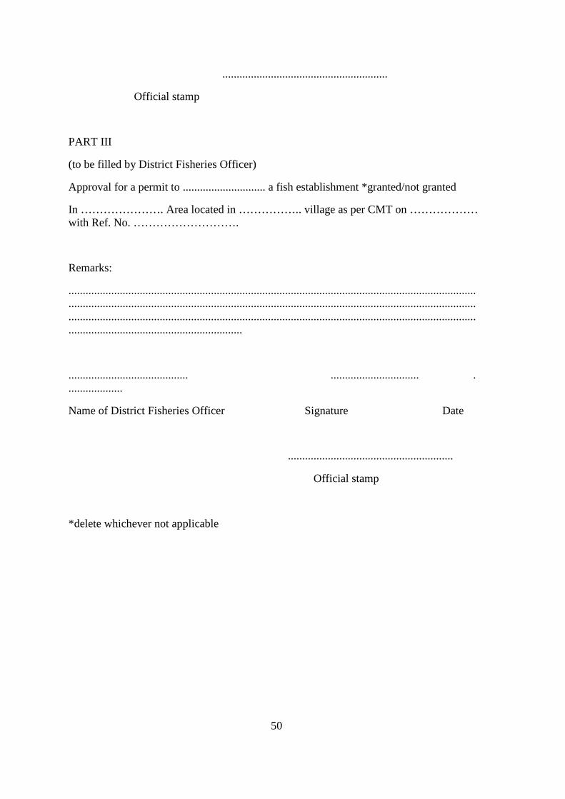
(to be filled by District Fisheries Officer)
Approval for a permit to ............................. a fish establishment *granted/not granted
In …………………. Area located in …………….. village as per CMT on ……………… with Ref. No. ……………………….
Remarks:
...............................................................................................................................................
...............................................................................................................................................
...............................................................................................................................................
.............................................................
.......................................... ............................... .
...................
Name of District Fisheries Officer Signature Date
..........................................................
Official stamp
*delete whichever not applicable
51
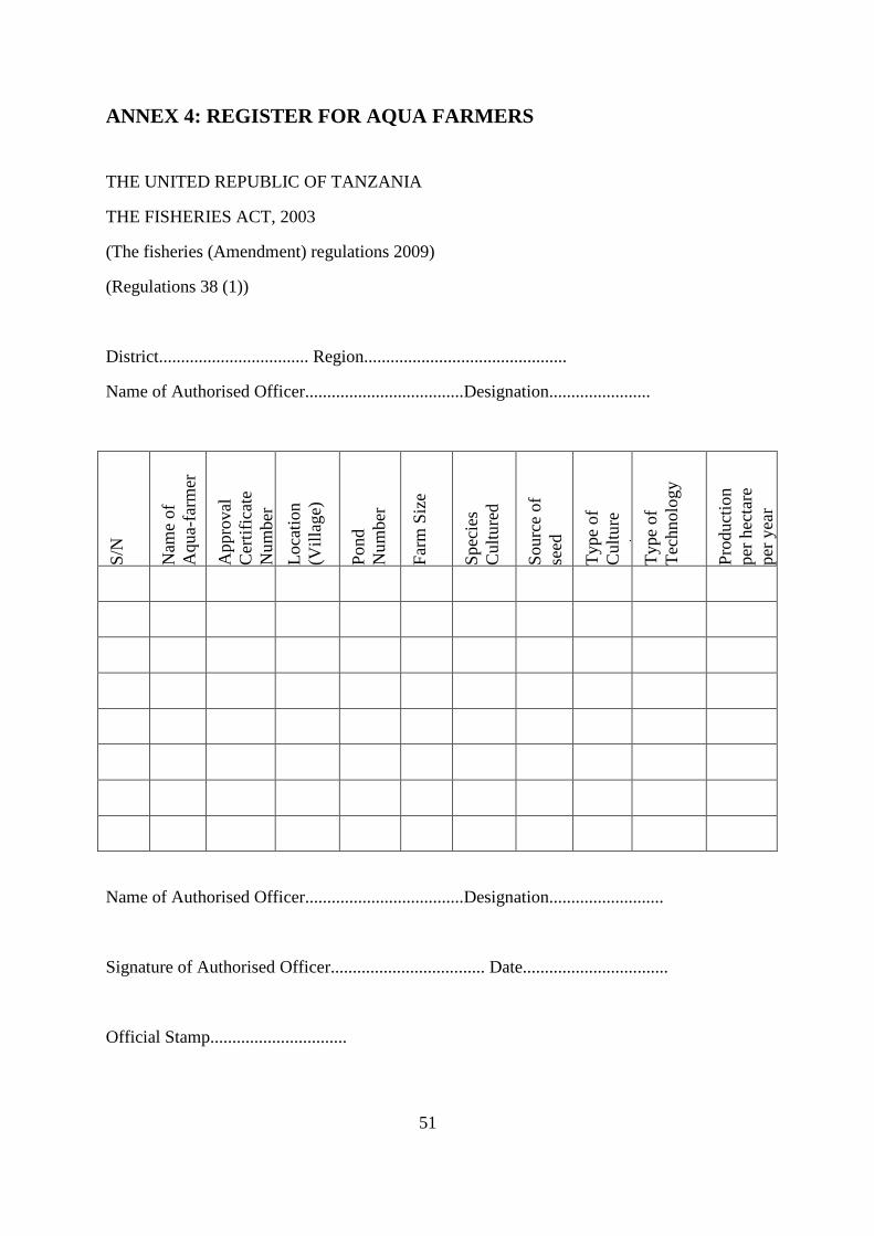
ANNEX 4: REGISTER FOR AQUA FARMERS
THE UNITED REPUBLIC OF TANZANIA
THE FISHERIES ACT, 2003
(The fisheries (Amendment) regulations 2009)
(Regulations 38 (1))
District.................................. Region..............................................
Name of Authorised Officer....................................Designation.......................
S/N
Nam
e of
A
qua-
farm
er
App
rova
l C
ertif
icat
e N
umbe
r
Lo
catio
n (V
illag
e)
Pond
N
umbe
r
Farm
Siz
e
Spec
ies
Cul
ture
d
Sour
ce o
f se
ed
Type
of
Cul
ture
sy
stem
Ty
pe o
f Te
chno
logy
Prod
uctio
n pe
r hec
tare
pe
r yea
r
Name of Authorised Officer....................................Designation..........................
Signature of Authorised Officer................................... Date.................................
Official Stamp...............................
52
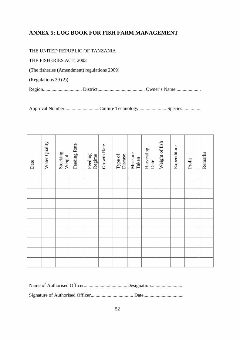
ANNEX 5: LOG BOOK FOR FISH FARM MANAGEMENT
THE UNITED REPUBLIC OF TANZANIA
THE FISHERIES ACT, 2003
(The fisheries (Amendment) regulations 2009)
(Regulations 39 (2))
Region................................ District....................................... Owner’s Name.....................
Approval Number.............................Culture Technology....................... Species...............
Name of Authorised Officer....................................Designation..........................
Signature of Authorised Officer................................... Date.................................
Dat
e
Wat
er Q
ualit
y
Stoc
king
W
eigh
t
Feed
ing
Rat
e
Feed
ing
Reg
ime
Gro
wth
Rat
e
Type
of
Dis
ease
Mea
sure
Ta
ken
Har
vest
ing
Dat
e
Wei
ght o
f fis
h
Expe
nditu
re
Prof
it
Rem
arks
53
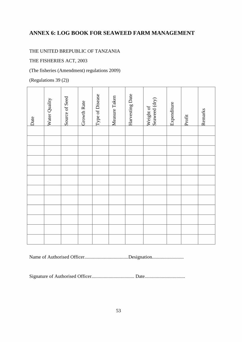
ANNEX 6: LOG BOOK FOR SEAWEED FARM MANAGEMENT
THE UNITED BREPUBLIC OF TANZANIA
THE FISHERIES ACT, 2003
(The fisheries (Amendment) regulations 2009)
(Regulations 39 (2))
Dat
e
Wat
er Q
ualit
y
Sour
ce o
f See
d
Gro
wth
Rat
e
Type
of D
isea
se
Mea
sure
Tak
en
Har
vest
ing
Dat
e
Wei
ght o
f Se
awee
d (d
ry)
Expe
nditu
re
Prof
it
Rem
arks
Name of Authorised Officer....................................Designation..........................
Signature of Authorised Officer................................... Date.................................
54
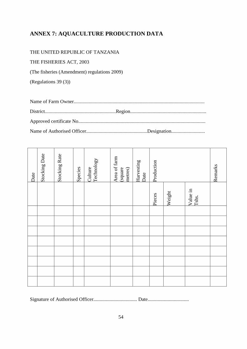
ANNEX 7: AQUACULTURE PRODUCTION DATA
THE UNITED REPUBLIC OF TANZANIA
THE FISHERIES ACT, 2003
(The fisheries (Amendment) regulations 2009)
(Regulations 39 (3))
Name of Farm Owner.........................................................................................................
District.........................................................Region.............................................................
Approved certificate No......................................................................................................
Name of Authorised Officer.................................................Designation...........................
Dat
e
Stoc
king
Dat
e
Stoc
king
Rat
e
Spec
ies
Cul
ture
Te
chno
logy
Are
a of
farm
(s
quar
e m
etre
s)
Har
vest
ing
Dat
e
Prod
uctio
n
Rem
arks
Piec
es
Wei
ght
Val
ue in
Ts
hs.
Signature of Authorised Officer................................... Date.................................
55
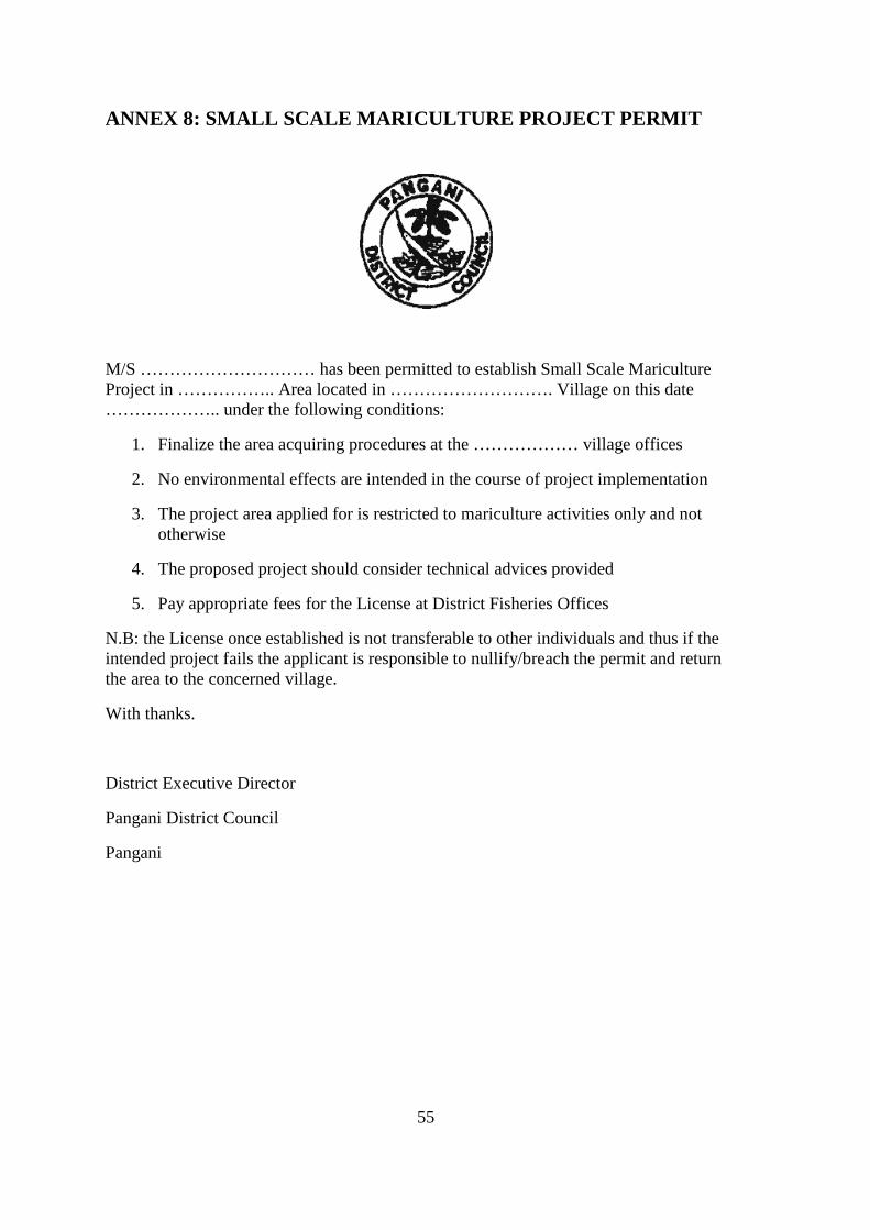
ANNEX 8: SMALL SCALE MARICULTURE PROJECT PERMIT
M/S ………………………… has been permitted to establish Small Scale Mariculture Project in …………….. Area located in ………………………. Village on this date ……………….. under the following conditions:
1. Finalize the area acquiring procedures at the ……………… village offices
2. No environmental effects are intended in the course of project implementation
3. The project area applied for is restricted to mariculture activities only and not otherwise
4. The proposed project should consider technical advices provided
5. Pay appropriate fees for the License at District Fisheries Offices
N.B: the License once established is not transferable to other individuals and thus if the intended project fails the applicant is responsible to nullify/breach the permit and return the area to the concerned village.
With thanks.
District Executive Director
Pangani District Council
Pangani
56
ANNEX 9: CERTIFICATE OF APPROVAL FOR FISH OR AQUACULTURE* ESTABLISHMENT
THE UNITED REPUBLIC OF TANZANIA
THE FISHERIES ACT, No 22 OF 2003
(The fisheries (Amendment) regulations 2009)
(Regulations 77 (11) 80(7) and 81 (7))
This is to certify that the fish/ Aquaculture establishment (name)..........................................
With approval (APP. No)......................................Owned by..................................................
Located on Plot No.......................................situated in.........................................................
(village/township/ocean)* has been inspected and found to be compliant for the purpose of (farming/holding/preparation/processing/storing/transporting/fishing/collecting)*.................................................................................................................................................................................................................................................................................................................
Subject to the following conditions:
The Fish or Aquaculture establishment shall conform to the requirements of Fisheries Act, 2003 and its Regulation thereof
This approval certificate is not transferable
Any change in the ownership of this Certified Fish or Aquaculture establishment shall automatically invalidate this certificate.
This certificate shall be displayed conspicuously in the Fish or Aquaculture establishment.
This certificate is valid from................................................to..................................
Full name of Fisheries Officer..................................................................................
Signature.................................................................... Date of issue...........................
....................................................................
Official Stamp
*Delete whichever is not applicable
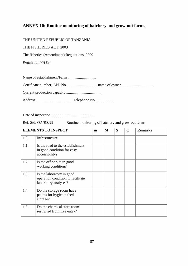
57
ANNEX 10: Routine monitoring of hatchery and grow-out farms
THE UNITED REPUBLIC OF TANZANIA
THE FISHERIES ACT, 2003
The fisheries (Amendment) Regulations, 2009
Regulation 77(15)
Name of establishment/Farm ..............................
Certificate number; APP No. ............................... name of owner .................................
Current production capacity .....................................
Address ...................................... Telephone No. ..................
Date of inspection ..............................................
Ref. Std: QA/RS/29 Routine monitoring of hatchery and grow-out farms
ELEMENTS TO INSPECT m M S C Remarks
1.0 Infrastructure
1.1 Is the road to the establishment in good condition for easy accessibility?
1.2 Is the office site in good working condition?
1.3 Is the laboratory in good operation condition to facilitate laboratory analyses?
1.4 Do the storage room have pallets for hygienic feed storage?
1.5 Do the chemical store room restricted from free entry?
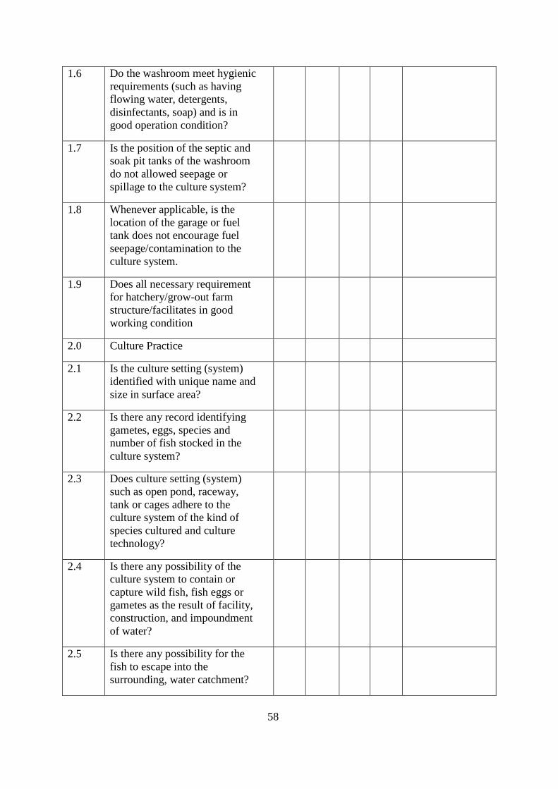
58
1.6 Do the washroom meet hygienic requirements (such as having flowing water, detergents, disinfectants, soap) and is in good operation condition?
1.7 Is the position of the septic and soak pit tanks of the washroom do not allowed seepage or spillage to the culture system?
1.8 Whenever applicable, is the location of the garage or fuel tank does not encourage fuel seepage/contamination to the culture system.
1.9 Does all necessary requirement for hatchery/grow-out farm structure/facilitates in good working condition
2.0 Culture Practice
2.1 Is the culture setting (system) identified with unique name and size in surface area?
2.2 Is there any record identifying gametes, eggs, species and number of fish stocked in the culture system?
2.3 Does culture setting (system) such as open pond, raceway, tank or cages adhere to the culture system of the kind of species cultured and culture technology?
2.4 Is there any possibility of the culture system to contain or capture wild fish, fish eggs or gametes as the result of facility, construction, and impoundment of water?
2.5 Is there any possibility for the fish to escape into the surrounding, water catchment?
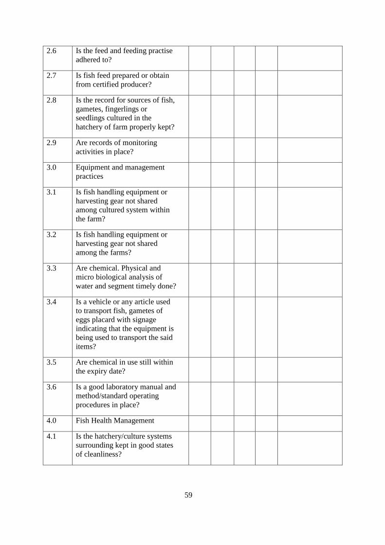
59
2.6 Is the feed and feeding practise adhered to?
2.7 Is fish feed prepared or obtain from certified producer?
2.8 Is the record for sources of fish, gametes, fingerlings or seedlings cultured in the hatchery of farm properly kept?
2.9 Are records of monitoring activities in place?
3.0 Equipment and management practices
3.1 Is fish handling equipment or harvesting gear not shared among cultured system within the farm?
3.2 Is fish handling equipment or harvesting gear not shared among the farms?
3.3 Are chemical. Physical and micro biological analysis of water and segment timely done?
3.4 Is a vehicle or any article used to transport fish, gametes of eggs placard with signage indicating that the equipment is being used to transport the said items?
3.5 Are chemical in use still within the expiry date?
3.6 Is a good laboratory manual and method/standard operating procedures in place?
4.0 Fish Health Management
4.1 Is the hatchery/culture systems surrounding kept in good states of cleanliness?
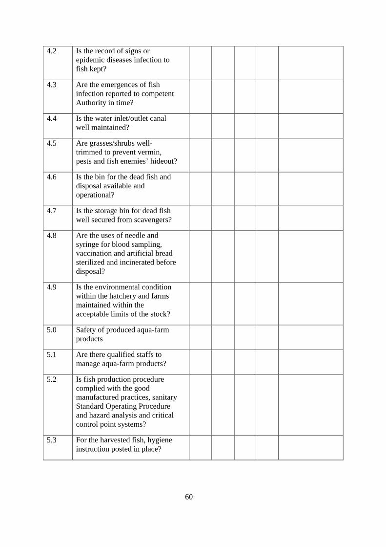
60
4.2 Is the record of signs or epidemic diseases infection to fish kept?
4.3 Are the emergences of fish infection reported to competent Authority in time?
4.4 Is the water inlet/outlet canal well maintained?
4.5 Are grasses/shrubs well-trimmed to prevent vermin, pests and fish enemies’ hideout?
4.6 Is the bin for the dead fish and disposal available and operational?
4.7 Is the storage bin for dead fish well secured from scavengers?
4.8 Are the uses of needle and syringe for blood sampling, vaccination and artificial bread sterilized and incinerated before disposal?
4.9 Is the environmental condition within the hatchery and farms maintained within the acceptable limits of the stock?
5.0 Safety of produced aqua-farm products
5.1 Are there qualified staffs to manage aqua-farm products?
5.2 Is fish production procedure complied with the good manufactured practices, sanitary Standard Operating Procedure and hazard analysis and critical control point systems?
5.3 For the harvested fish, hygiene instruction posted in place?
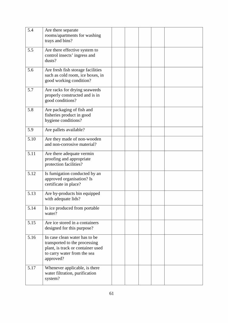
61
5.4 Are there separate rooms/apartments for washing trays and bins?
5.5 Are there effective system to control insects’ ingress and dusts?
5.6 Are fresh fish storage facilities such as cold room, ice boxes, in good working condition?
5.7 Are racks for drying seaweeds properly constructed and is in good conditions?
5.8 Are packaging of fish and fisheries product in good hygiene conditions?
5.9 Are pallets available?
5.10 Are they made of non-wooden and non-corrosive material?
5.11 Are there adequate vermin proofing and appropriate protection facilities?
5.12 Is fumigation conducted by an approved organisation? Is certificate in place?
5.13 Are by-products bin equipped with adequate lids?
5.14 Is ice produced from portable water?
5.15 Are ice stored in a containers designed for this purpose?
5.16 In case clean water has to be transported to the processing plant, is track or container used to carry water from the sea approved?
5.17 Whenever applicable, is there water filtration, purification system?
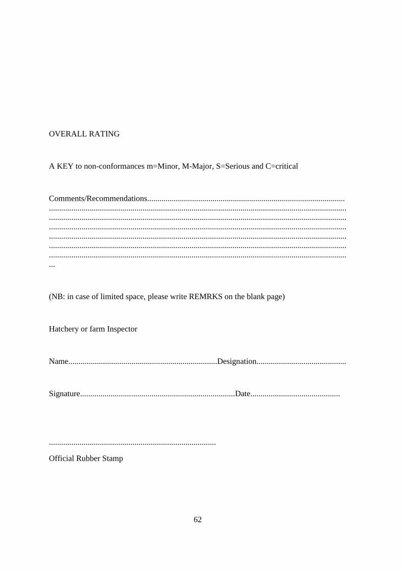
62
OVERALL RATING
A KEY to non-conformances m=Minor, M-Major, S=Serious and C=critical
Comments/Recommendations................................................................................................................................................................................................................................................................................................................................................................................................................................................................................................................................................................................................................................................................................................................................................................................................................................................................................................................................................................................................................
(NB: in case of limited space, please write REMRKS on the blank page)
Hatchery or farm Inspector
Name.........................................................................Designation............................................
Signature............................................................................Date............................................
..................................................................................
Official Rubber Stamp
63
ANNEX 11: Checklist for the Village Government Committee Every person seeking a permit to build and operate ponds for growing finfish or shellfish need to demonstrate to the Village, Ward and District government that they have the permit to utilize, that their project will not negatively interfere with any other activities in the village where it is to be located, will not negatively interfere with projects or land use rights held by others, and that it is consistent with the development plans in the village. National law protects mangroves and the District will review the application to be sure that the project does not infringe upon mangrove areas, as well as to verify all of the facts presented in the application. If the village is satisfied with the proposal, it will submit the proposal and its recommendations to the districts for review by CMT. The village has the responsibility to give comments to the District to consider during the application review period. The village will be consulted again during the application review process before a final decision is made.
The Village is required to submit a letter of its provisional consent, together with comments to the District Fisheries Officer (Aquaculture), to accompany the applicants' submission.
Checklist for Village and Ward Yes No Comments
Was the specific purpose of the project as described by the applicant reviewed?
Was a written presentation of the project proposal submitted? Was it reviewed?
Was a sketch map of the project area submitted?
Was it verified in the field?
Was it approved?
Location of the project site. Was it indicated?
Was it visited?
Is it within an approved zone?
Was it approved?
Other activities in the area
Are there other activities in the proposed project site?
Are the activities related to aquaculture ponds?
64
Possible conflicts between the project and other activities in the area. Are there possible conflicts?
List of conflicts/concerns
Development goals of the village and ward.
Is the project consistent?
How will it interfere with goals, plans and life in the village:
Ownership or permit for the area where the project is to be carried out.
Has the applicant an ownership/permit?
If yes, is evidence provided?
Ability of the applicant to implement the project. Is the applicant able?1
Are there any concerns about the applicant?
List of concerns:
1 At least financially and technically 2 Ward is mentioned here as a power centre
65
ANNEX 12: Checklist for the District Technical Team The role of the District Technical Team is to ensure that the applicant for a permit to build an aquaculture project has properly completed the application form, has consulted with the village and ward where the project is to be located, and possesses access to the location. The DTT is then is responsible for verifying the information in the application and evaluating the proposal in respect to the policies and rules set out by this ordinance.
The following worksheet is an aid to this review process.
Checklist for District Technical Team Yes No Comments
1) Review the application form for completeness, preferably at the time the applicant submits it to the District office. This should include any other attachments as requested in the application form.
Is it complete?
2) Threshold Review: If any of the following are true, inform the applicant to either revise the proposal or submit the application for review by NEMC
a. The project is greater than 10 hectares in size
b. The project would result in more than 20 percent of the combined mangrove and salt flats in the estuary containing aquaculture operations. Check with the Pangani coastal aquaculture maps and related tables to calculate this.
c. The per cent of the salt flat area that will be occupied by aquaculture ponds is more than 80%. d. The applicant is not the party with permit/, ownership or concession for the site from the Village, Ward or District
e. The project appears to generate significant environmental impacts through construction or operation, or is partly or wholly within a geographic area where aquaculture uses are prohibited.
f. The project involves intensive culture technology. The DTT does not have the legal and technical capability of reviewing this type of project.
g. The project involves the cultivation of exotic species. The DTT does not have the legal and technical capability of reviewing this type of species.
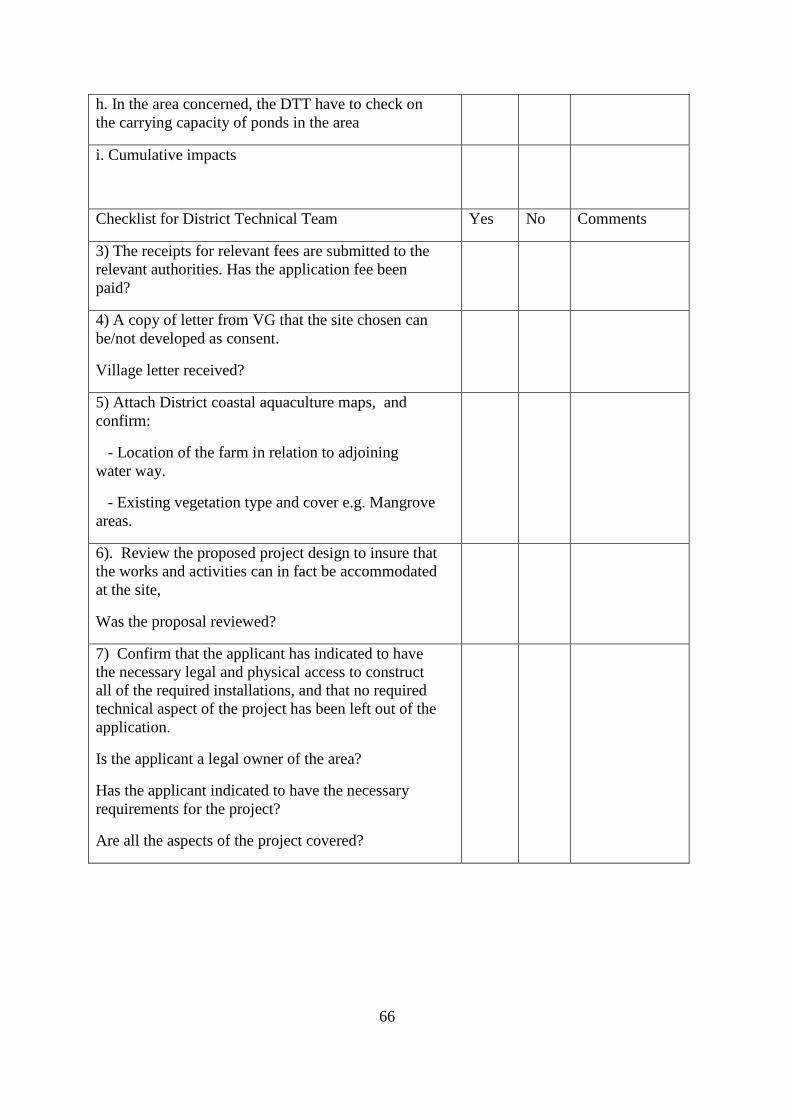
66
h. In the area concerned, the DTT have to check on the carrying capacity of ponds in the area i. Cumulative impacts
Checklist for District Technical Team Yes No Comments
3) The receipts for relevant fees are submitted to the relevant authorities. Has the application fee been paid?
4) A copy of letter from VG that the site chosen can be/not developed as consent.
Village letter received?
5) Attach District coastal aquaculture maps, and confirm:
- Location of the farm in relation to adjoining water way.
- Existing vegetation type and cover e.g. Mangrove areas.
6). Review the proposed project design to insure that the works and activities can in fact be accommodated at the site,
Was the proposal reviewed?
7) Confirm that the applicant has indicated to have the necessary legal and physical access to construct all of the required installations, and that no required technical aspect of the project has been left out of the application.
Is the applicant a legal owner of the area?
Has the applicant indicated to have the necessary requirements for the project?
Are all the aspects of the project covered?
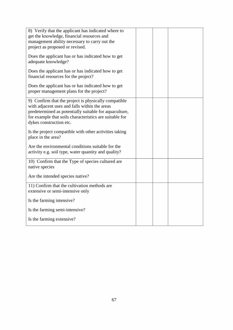
67
8) Verify that the applicant has indicated where to get the knowledge, financial resources and management ability necessary to carry out the project as proposed or revised.
Does the applicant has or has indicated how to get adequate knowledge?
Does the applicant has or has indicated how to get financial resources for the project?
Does the applicant has or has indicated how to get proper management plans for the project?
9) Confirm that the project is physically compatible with adjacent uses and falls within the areas predetermined as potentially suitable for aquaculture, for example that soils characteristics are suitable for dykes construction etc.
Is the project compatible with other activities taking place in the area?
Are the environmental conditions suitable for the activity e.g. soil type, water quantity and quality?
10) Confirm that the Type of species cultured are native species
Are the intended species native?
11) Confirm that the cultivation methods are extensive or semi-intensive only
Is the farming intensive?
Is the farming semi-intensive?
Is the farming extensive?
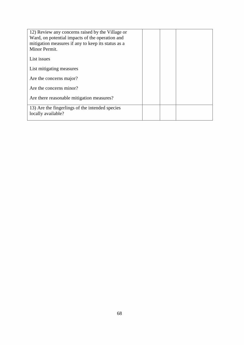
68
12) Review any concerns raised by the Village or Ward, on potential impacts of the operation and mitigation measures if any to keep its status as a Minor Permit.
List issues
List mitigating measures
Are the concerns major?
Are the concerns minor?
Are there reasonable mitigation measures?
13) Are the fingerlings of the intended species locally available?
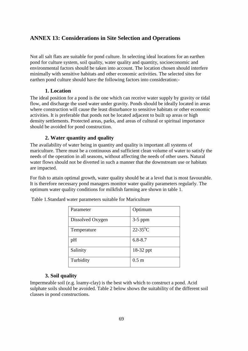
69
ANNEX 13: Considerations in Site Selection and Operations
Not all salt flats are suitable for pond culture. In selecting ideal locations for an earthen pond for culture system, soil quality, water quality and quantity, socioeconomic and environmental factors should be taken into account. The location chosen should interfere minimally with sensitive habitats and other economic activities. The selected sites for earthen pond culture should have the following factors into consideration:-
1. Location The ideal position for a pond is the one which can receive water supply by gravity or tidal flow, and discharge the used water under gravity. Ponds should be ideally located in areas where construction will cause the least disturbance to sensitive habitats or other economic activities. It is preferable that ponds not be located adjacent to built up areas or high density settlements. Protected areas, parks, and areas of cultural or spiritual importance should be avoided for pond construction.
2. Water quantity and quality The availability of water being in quantity and quality is important all systems of mariculture. There must be a continuous and sufficient clean volume of water to satisfy the needs of the operation in all seasons, without affecting the needs of other users. Natural water flows should not be diverted in such a manner that the downstream use or habitats are impacted.
For fish to attain optimal growth, water quality should be at a level that is most favourable. It is therefore necessary pond managers monitor water quality parameters regularly. The optimum water quality conditions for milkfish farming are shown in table 1.
Table 1.Standard water parameters suitable for Mariculture
Parameter Optimum
Dissolved Oxygen 3-5 ppm
Temperature 22-35oC
pH 6.8-8.7
Salinity 18-32 ppt
Turbidity 0.5 m
3. Soil quality Impermeable soil (e.g. loamy-clay) is the best with which to construct a pond. Acid sulphate soils should be avoided. Table 2 below shows the suitability of the different soil classes in pond constructions.
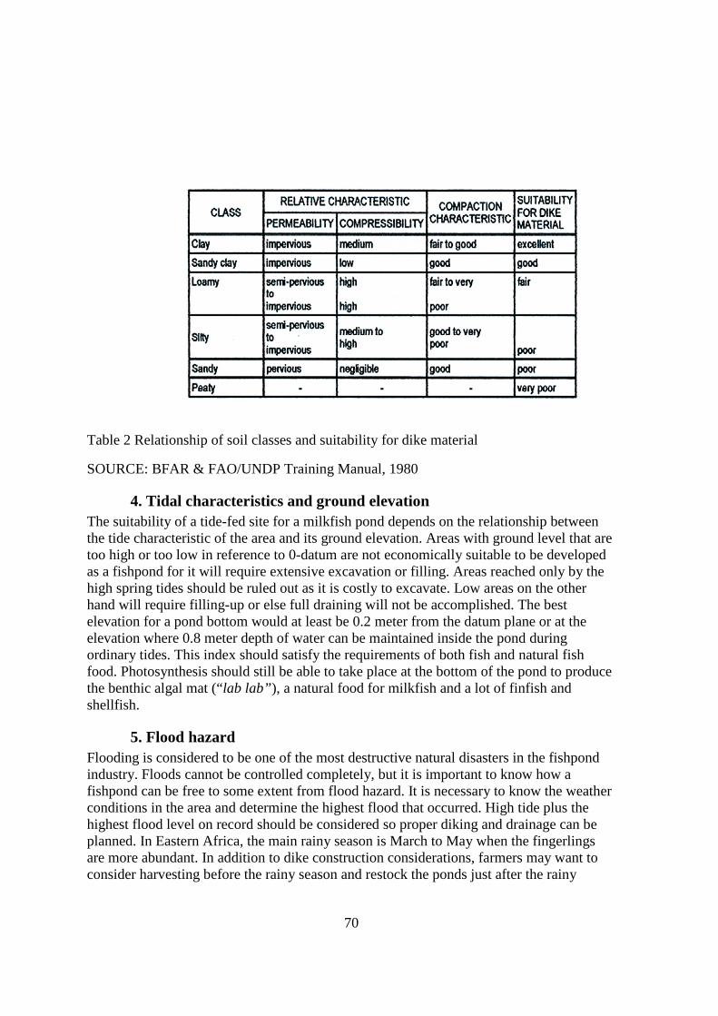
70
Table 2 Relationship of soil classes and suitability for dike material
SOURCE: BFAR & FAO/UNDP Training Manual, 1980
4. Tidal characteristics and ground elevation The suitability of a tide-fed site for a milkfish pond depends on the relationship between the tide characteristic of the area and its ground elevation. Areas with ground level that are too high or too low in reference to 0-datum are not economically suitable to be developed as a fishpond for it will require extensive excavation or filling. Areas reached only by the high spring tides should be ruled out as it is costly to excavate. Low areas on the other hand will require filling-up or else full draining will not be accomplished. The best elevation for a pond bottom would at least be 0.2 meter from the datum plane or at the elevation where 0.8 meter depth of water can be maintained inside the pond during ordinary tides. This index should satisfy the requirements of both fish and natural fish food. Photosynthesis should still be able to take place at the bottom of the pond to produce the benthic algal mat (“lab lab”), a natural food for milkfish and a lot of finfish and shellfish.
5. Flood hazard Flooding is considered to be one of the most destructive natural disasters in the fishpond industry. Floods cannot be controlled completely, but it is important to know how a fishpond can be free to some extent from flood hazard. It is necessary to know the weather conditions in the area and determine the highest flood that occurred. High tide plus the highest flood level on record should be considered so proper diking and drainage can be planned. In Eastern Africa, the main rainy season is March to May when the fingerlings are more abundant. In addition to dike construction considerations, farmers may want to consider harvesting before the rainy season and restock the ponds just after the rainy
71
season. This is considered important since some unpredictable flooding usually occur in connection with the equinox and related phenomenon (e.g. March 2007 episode)
6. Climatic conditions Seasonal climatic changes are important in scheduling and managing fishpond operations. The climatic elements that concern most operators are rainfall, temperature and prevailing wind direction because they greatly affect fish production directly or indirectly. Data on rainfall and wind direction are necessary in planning the layout and design of pond system. Knowing the past rainfall record can help the investor decide on dike heights or whether to include drainage canals. Winds can also be very destructive since they generate wave action that can destroy the sides of the dikes. By knowing the prevailing wind direction, dike positioning can be planned, by exposing the least area possible to damaging waves. Heavy rain can suddenly change the salinity and temperature of pond water, which can be detrimental to fish. It is also important to know the period of the rainy season as this will affect pond preparation and stocking cycles. Drying of pond bottoms cannot be accomplished during rainy days but is a necessary step prior to stocking to reduce likelihood of disease outbreaks.
7. Type and density of vegetation It is highly recommended that pond sites be selected primarily in salt flat areas behind mangrove stands. Large scale clearing is not recommended as it increases construction costs and is environmentally destructive.
8. Fingerling availability The availability of fish fingerlings should be determined before the area for pond culture is located. The distance from the catch to the pond should be less than 3 hours of travel.
9. Supportive entrepreneurial Environment • Skilled and unskilled labour
• Infrastructure and telecommunication for supporting transportation of kilns, ice and other storage facilities and construction material.
• Production inputs- seeds, feeds, fertilizers
• Financial sources/credit facilities
• Security and Bio-safety of products
10. Marketing • Reliable markets