Embed Size (px)
Citation preview
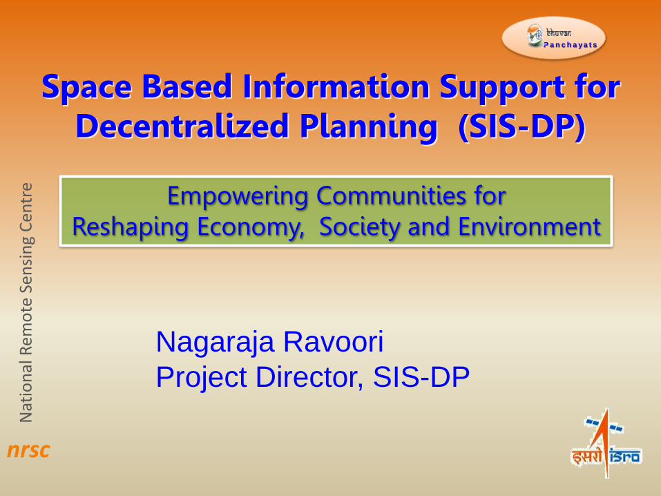
Space Based Information Support for Decentralized Planning (SIS-DP)
Nat
ion
al R
emo
te S
ensi
ng
Cen
tre
P a n c h a y a t s
Empowering Communities for Reshaping Economy, Society and Environment
nrsc
Nagaraja Ravoori
Project Director, SIS-DP
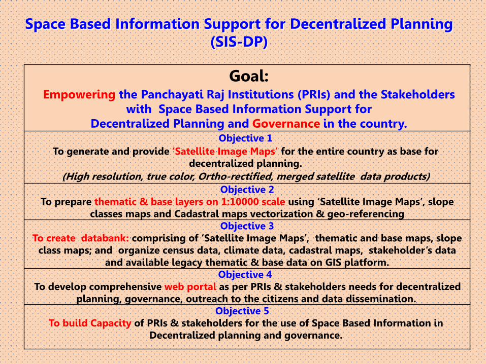
Goal: Empowering the Panchayati Raj Institutions (PRIs) and the Stakeholders
with Space Based Information Support for Decentralized Planning and Governance in the country.
Objective 1
To generate and provide ‘Satellite Image Maps’ for the entire country as base for decentralized planning.
(High resolution, true color, Ortho-rectified, merged satellite data products) Objective 2
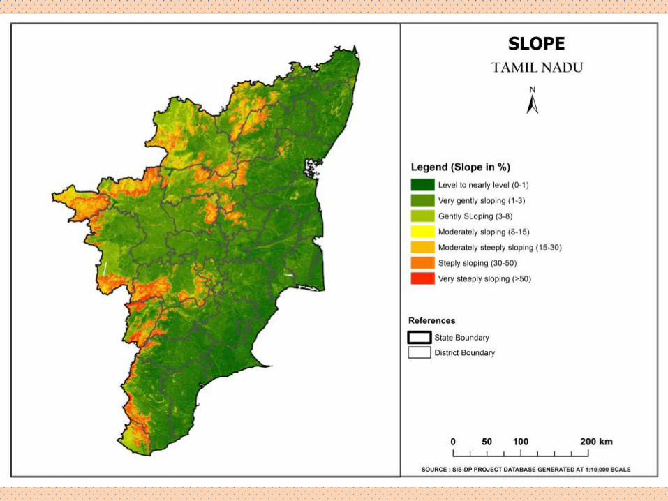
To prepare thematic & base layers on 1:10000 scale using ‘Satellite Image Maps’, slope classes maps and Cadastral maps vectorization & geo-referencing
Objective 3 To create databank: comprising of ‘Satellite Image Maps’, thematic and base maps, slope
class maps; and organize census data, climate data, cadastral maps, stakeholder’s data and available legacy thematic & base data on GIS platform.
Objective 4 To develop comprehensive web portal as per PRIs & stakeholders needs for decentralized
planning, governance, outreach to the citizens and data dissemination. Objective 5
To build Capacity of PRIs & stakeholders for the use of Space Based Information in Decentralized planning and governance.
Space Based Information Support for Decentralized Planning (SIS-DP)
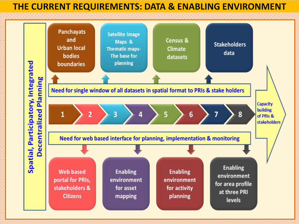
THE CURRENT REQUIREMENTS: DATA & ENABLING ENVIRONMENT
Project work flow
National MIS Monitoring
State
State Data Repository Creation & Updating
District
District database Usage and updating
Panchayat
Usage through customized interface
Role
New (1:10K)
Existing
Comm. Highway
Existing/ongoing (1:50K)
New
User Projects • Ground Water Prospect
(RGNDWM)
• Wastelands
• Irrigation Infrastructure
(AIBP)
• Watershed
• National Urban Information
System
• Biodiversity
• Watershed Prioritisation
• Tribal Development
ISRO
NR Census layers • Land Use / Land Cover
• Land Degradation
• Forest & Vegetation
• Wetlands
• Snow & Glacier
• Geomorphology
• Soil
Periodicity • Every 5 years
• Every 20 years
Periodic Space based
Monitoring
Resourcesat-2, Cartosat-3
…… ISRO EO Missions
Customized Dissemination
Satellite Data (Cartosat – 1, 2 /
LISS MX IV)
Land Cover, Road,
Settlement, Drainage
& WB, Linking of
Legacy Data,Slope
(DEM)
Digital village cadastral
maps, attribute linking
(Existing digital maps if
available will be used)
4/5 states, NLRMP
Cadastral (Digital Maps)
Based upon Policy: G2G, G2C
Assured Continuity
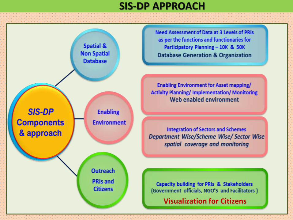
SIS-DP APPROACH
Visualization for Citizens
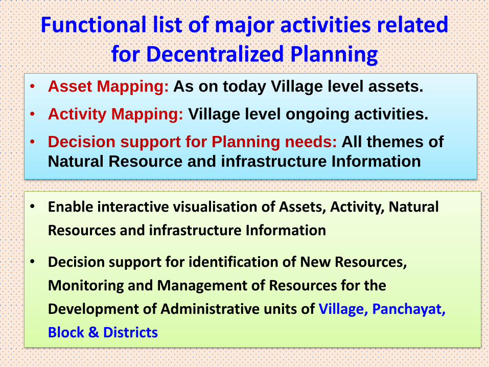
Functional list of major activities related for Decentralized Planning
• Asset Mapping: As on today Village level assets.
• Activity Mapping: Village level ongoing activities.
• Decision support for Planning needs: All themes of
Natural Resource and infrastructure Information
• Enable interactive visualisation of Assets, Activity, Natural
Resources and infrastructure Information
• Decision support for identification of New Resources,
Monitoring and Management of Resources for the
Development of Administrative units of Village, Panchayat,
Block & Districts
SIS-DP Conceptual Framework
1. Database Generation and Organization Spatial & non spatial data
NRSC & States Centres / partners
2. Enabling Environment for PRI’s Web Based System for PRIs – Four modules
NRSC / ISRO
3. Outreach PRIs & Citizens
NRSC & States Centres /partners
Capacity
Building
Implementation
&
Monitoring
Village (Gram Panchayat)
& Urban local bodies
Block (Panchayat Samiti)
District (Zilla Parishad)
Identification of sector wise
issues at all levels of PRIs
Asset Mapping
&
Activity Planning
Geo-
Visualization
Search , Access, Understand
State Centres & NRSC / ISRO
PRIs, State Centres, NGOs, Citizens
PRIs, State Departments
NRSC / ISRO
Field Data
Socio-economic
Data
Climate Data
SIS-DP
Database
Earth Observation
Images
Bhuvan Panchayats
P a n c h a ya t s National Remote Sensing Centre
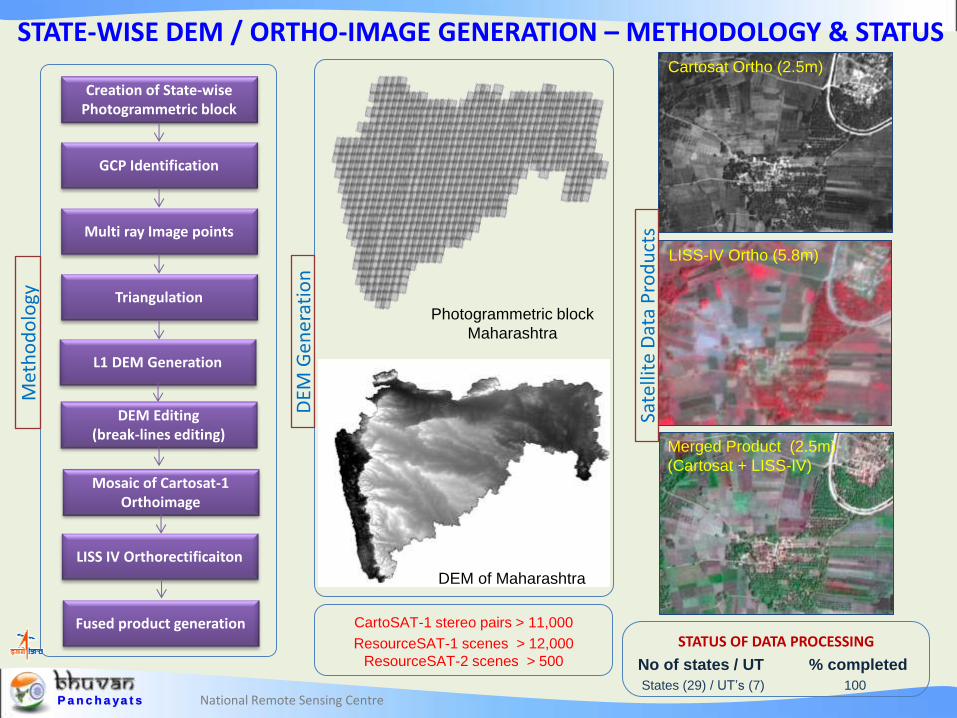
STATE-WISE DEM / ORTHO-IMAGE GENERATION – METHODOLOGY & STATUS
CartoSAT-1 stereo pairs > 11,000
ResourceSAT-1 scenes > 12,000
ResourceSAT-2 scenes > 500
Photogrammetric block
Maharashtra
Creation of State-wise Photogrammetric block
GCP Identification
Multi ray Image points
Triangulation
L1 DEM Generation
DEM Editing (break-lines editing)
Mosaic of Cartosat-1 Orthoimage
LISS IV Orthorectificaiton
Fused product generation
DEM of Maharashtra
LISS-IV Ortho (5.8m)
Merged Product (2.5m)
(Cartosat + LISS-IV)
Cartosat Ortho (2.5m)
STATUS OF DATA PROCESSING
No of states / UT % completed
States (29) / UT’s (7) 100
Met
ho
do
logy
DEM
Gen
erat
ion
Sate
llite
Dat
a P
rod
uct
s
National Remote Sensing Centre P a n c h a ya t s National Remote Sensing Centre
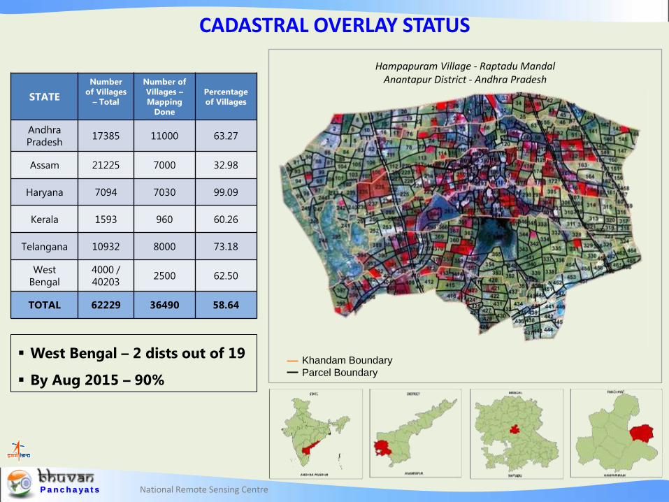
STATE
Number
of Villages
– Total
Number of
Villages –
Mapping
Done
Percentage
of Villages
Andhra
Pradesh 17385 11000 63.27
Assam 21225 7000 32.98
Haryana 7094 7030 99.09
Kerala 1593 960 60.26
Telangana 10932 8000 73.18
West
Bengal
4000 /
40203 2500 62.50
TOTAL 62229 36490 58.64
West Bengal – 2 dists out of 19
By Aug 2015 – 90%
CADASTRAL OVERLAY STATUS
Khandam Boundary
Parcel Boundary
Hampapuram Village - Raptadu Mandal Anantapur District - Andhra Pradesh
P a n c h a ya t s National Remote Sensing Centre
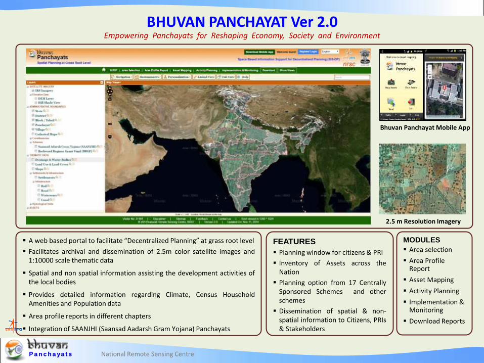
BHUVAN PANCHAYAT Ver 2.0 Empowering Panchayats for Reshaping Economy, Society and Environment
A web based portal to facilitate “Decentralized Planning” at grass root level
Facilitates archival and dissemination of 2.5m color satellite images and 1:10000 scale thematic data
Spatial and non spatial information assisting the development activities of the local bodies
Provides detailed information regarding Climate, Census Household Amenities and Population data
Area profile reports in different chapters
Integration of SAANJHI (Saansad Aadarsh Gram Yojana) Panchayats
MODULES
Area selection
Area Profile Report
Asset Mapping
Activity Planning
Implementation & Monitoring
Download Reports
FEATURES
Planning window for citizens & PRI
Inventory of Assets across the Nation
Planning option from 17 Centrally Sponsored Schemes and other schemes
Dissemination of spatial & non-spatial information to Citizens, PRIs & Stakeholders
Bhuvan Panchayat Mobile App
2.5 m Resolution Imagery
National Remote Sensing Centre
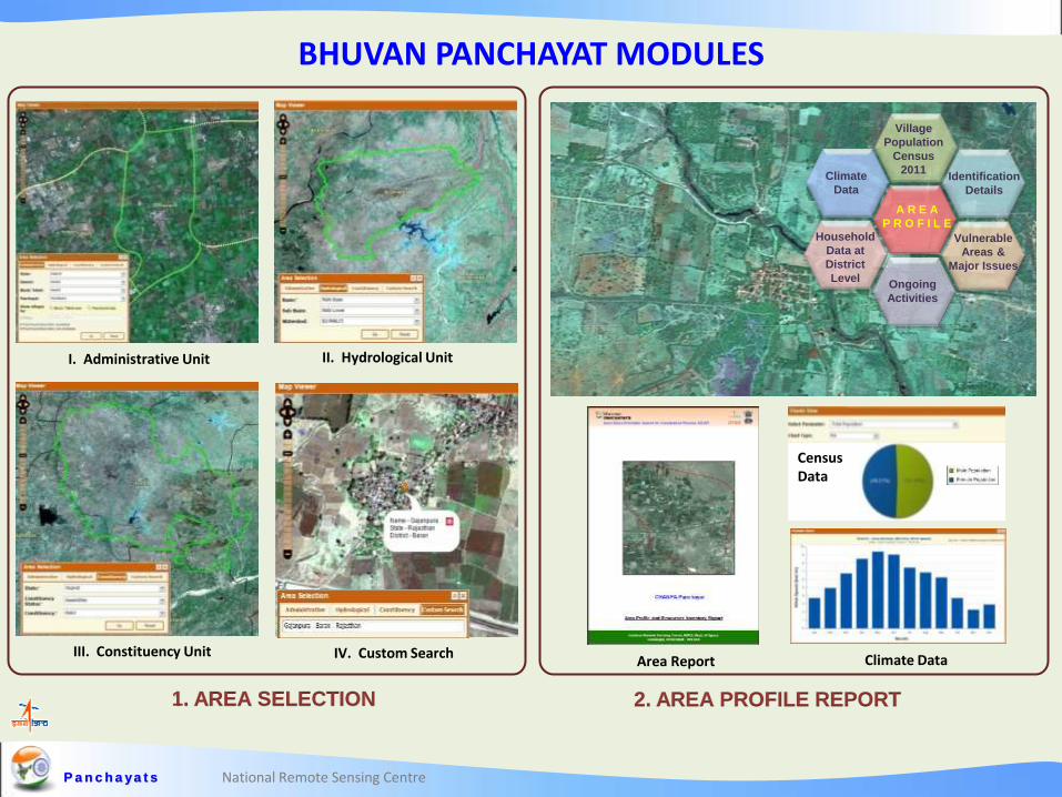
BHUVAN PANCHAYAT MODULES
P a n c h a ya t s
I. Administrative Unit II. Hydrological Unit
III. Constituency Unit IV. Custom Search
Vulnerable
Areas &
Major Issues
A R E A
P R O F I L E
Ongoing
Activities
Village
Population
Census
2011
Household
Data at
District
Level
Climate
Data Identification
Details
Census Data
Area Report Climate Data
1. AREA SELECTION 2. AREA PROFILE REPORT
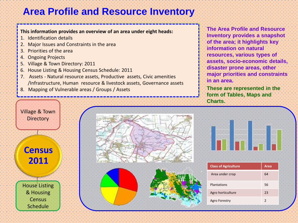
Area Profile and Resource Inventory
This information provides an overview of an area under eight heads: 1. Identification details 2. Major Issues and Constraints in the area 3. Priorities of the area 4. Ongoing Projects 5. Village & Town Directory: 2011 6. House Listing & Housing Census Schedule: 2011 7. Assets - Natural resource assets, Productive assets, Civic amenities /Infrastructure, Human resource & livestock assets, Governance assets 8. Mapping of Vulnerable areas / Groups / Assets
The Area Profile and Resource
Inventory provides a snapshot
of the area; it highlights key
information on natural
resources, various types of
assets, socio-economic details,
disaster prone areas, other
major priorities and constraints
in an area.
These are represented in the
form of Tables, Maps and
Charts.
Class of Agriculture Area
Area under crop 64
Plantations 56
Agro horticulture 23
Agro Forestry 2
House Listing & Housing
Census Schedule
Census 2011
Village & Town Directory
National Remote Sensing Centre
BHUVAN PANCHAYAT MODULES
P a n c h a ya t s
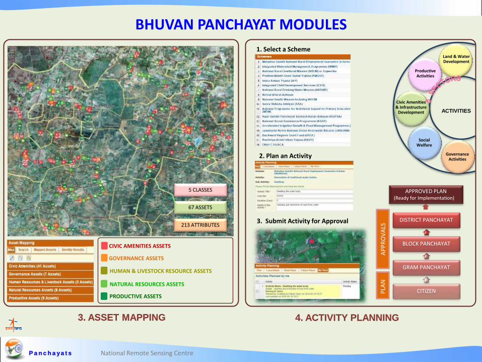
3. ASSET MAPPING 4. ACTIVITY PLANNING
5 CLASSES
213 ATTRIBUTES
67 ASSETS
Productive Activities
Civic Amenities & Infrastructure
Development
Social Welfare
Governance Activities
Land & Water Development
ACTIVITIES
1. Select a Scheme
2. Plan an Activity
3. Submit Activity for Approval DISTRICT PANCHAYAT
BLOCK PANCHAYAT
GRAM PANCHAYAT
CITIZEN PLA
N
AP
PR
OV
ALS
APPROVED PLAN (Ready for Implementation)
CIVIC AMENITIES ASSETS
GOVERNANCE ASSETS
HUMAN & LIVESTOCK RESOURCE ASSETS
PRODUCTIVE ASSETS
NATURAL RESOURCES ASSETS
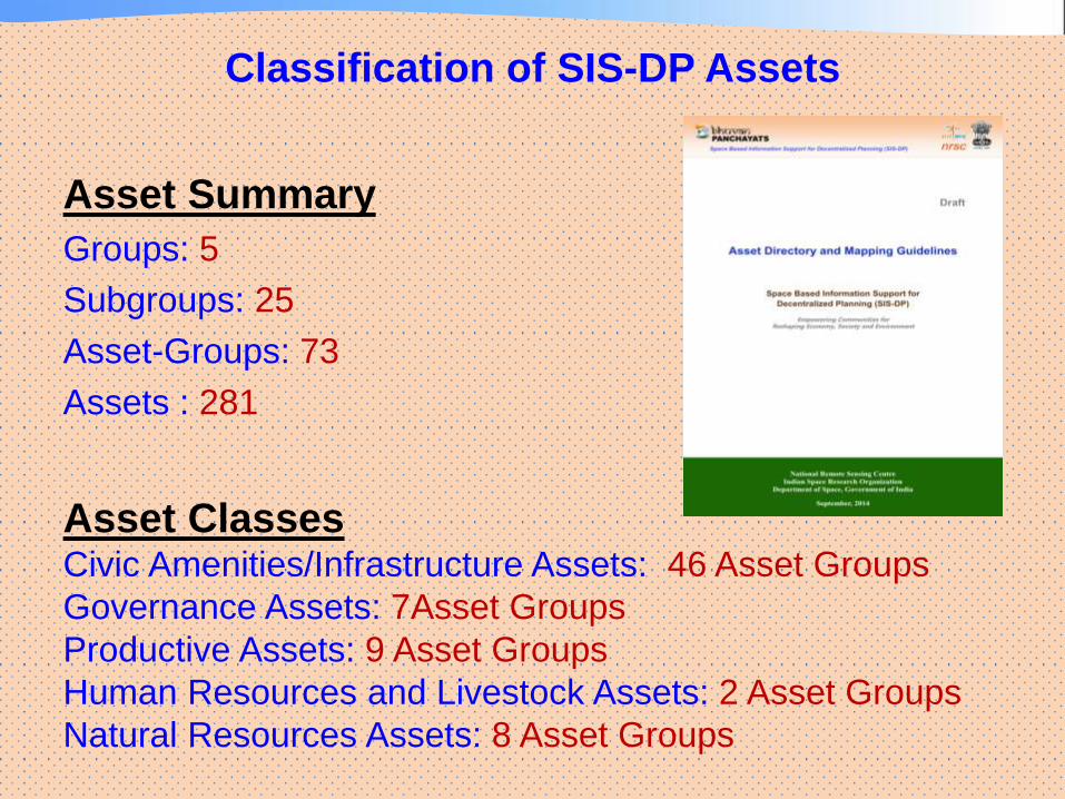
Classification of SIS-DP Assets
Asset Summary
Groups: 5
Subgroups: 25
Asset-Groups: 73
Assets : 281
Asset Classes Civic Amenities/Infrastructure Assets: 46 Asset Groups
Governance Assets: 7Asset Groups
Productive Assets: 9 Asset Groups
Human Resources and Livestock Assets: 2 Asset Groups
Natural Resources Assets: 8 Asset Groups
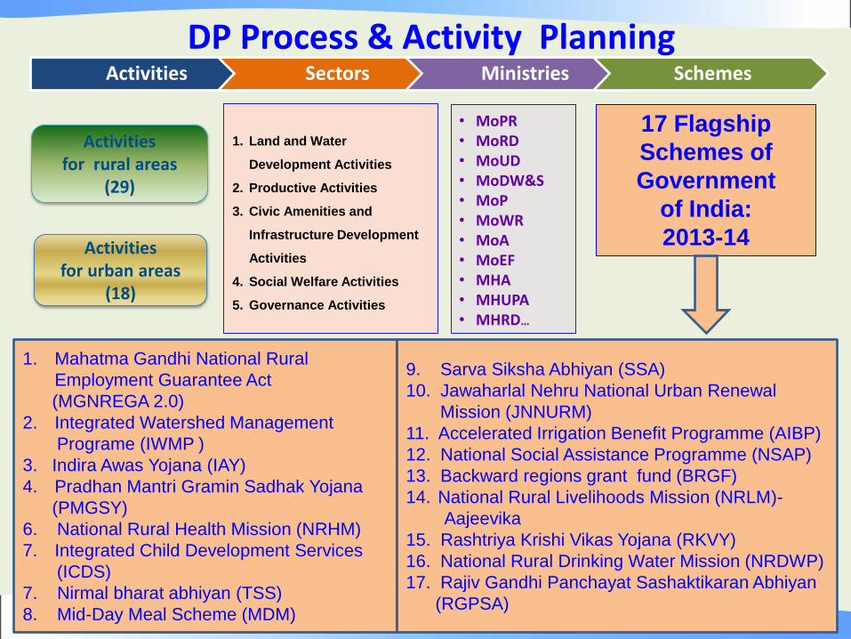
• MoPR • MoRD • MoUD • MoDW&S • MoP • MoWR • MoA • MoEF • MHA • MHUPA • MHRD…
1. Land and Water
Development Activities
2. Productive Activities
3. Civic Amenities and
Infrastructure Development
Activities
4. Social Welfare Activities
5. Governance Activities
Activities for rural areas
(29)
Activities for urban areas
(18)
Activities Sectors Ministries Schemes
DP Process & Activity Planning
1. Mahatma Gandhi National Rural
Employment Guarantee Act
(MGNREGA 2.0)
2. Integrated Watershed Management
Programe (IWMP )
3. Indira Awas Yojana (IAY)
4. Pradhan Mantri Gramin Sadhak Yojana
(PMGSY)
6. National Rural Health Mission (NRHM)
7. Integrated Child Development Services
(ICDS)
7. Nirmal bharat abhiyan (TSS)
8. Mid-Day Meal Scheme (MDM)
9. Sarva Siksha Abhiyan (SSA)
10. Jawaharlal Nehru National Urban Renewal
Mission (JNNURM)
11. Accelerated Irrigation Benefit Programme (AIBP)
12. National Social Assistance Programme (NSAP)
13. Backward regions grant fund (BRGF)
14. National Rural Livelihoods Mission (NRLM)-
Aajeevika
15. Rashtriya Krishi Vikas Yojana (RKVY)
16. National Rural Drinking Water Mission (NRDWP)
17. Rajiv Gandhi Panchayat Sashaktikaran Abhiyan
(RGPSA)
17 Flagship
Schemes of
Government
of India:
2013-14
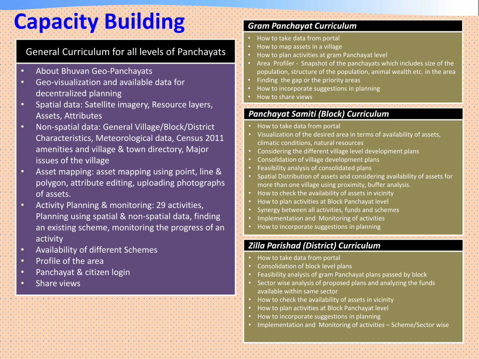
Capacity Building
• About Bhuvan Geo-Panchayats • Geo-visualization and available data for
decentralized planning • Spatial data: Satellite imagery, Resource layers,
Assets, Attributes • Non-spatial data: General Village/Block/District
Characteristics, Meteorological data, Census 2011 amenities and village & town directory, Major issues of the village
• Asset mapping: asset mapping using point, line & polygon, attribute editing, uploading photographs of assets.
• Activity Planning & monitoring: 29 activities, Planning using spatial & non-spatial data, finding an existing scheme, monitoring the progress of an activity
• Availability of different Schemes • Profile of the area • Panchayat & citizen login • Share views
General Curriculum for all levels of Panchayats
• How to take data from portal • How to map assets in a village • How to plan activities at gram Panchayat level • Area Profiler - Snapshot of the panchayats which includes size of the
population, structure of the population, animal wealth etc. in the area • Finding the gap or the priority areas • How to incorporate suggestions in planning • How to share views
• How to take data from portal • Visualization of the desired area in terms of availability of assets,
climatic conditions, natural resources • Considering the different village level development plans • Consolidation of village development plans • Feasibility analysis of consolidated plans • Spatial Distribution of assets and considering availability of assets for
more than one village using proximity, buffer analysis. • How to check the availability of assets in vicinity • How to plan activities at Block Panchayat level • Synergy between all activities, funds and schemes • Implementation and Monitoring of activities • How to incorporate suggestions in planning
Panchayat Samiti (Block) Curriculum
• How to take data from portal • Consolidation of block level plans • Feasibility analysis of gram Panchayat plans passed by block • Sector wise analysis of proposed plans and analyzing the funds
available within same sector • How to check the availability of assets in vicinity • How to plan activities at Block Panchayat level • How to incorporate suggestions in planning • Implementation and Monitoring of activities – Scheme/Sector wise
Zilla Parishad (District) Curriculum
Gram Panchayat Curriculum
National Remote Sensing Centre
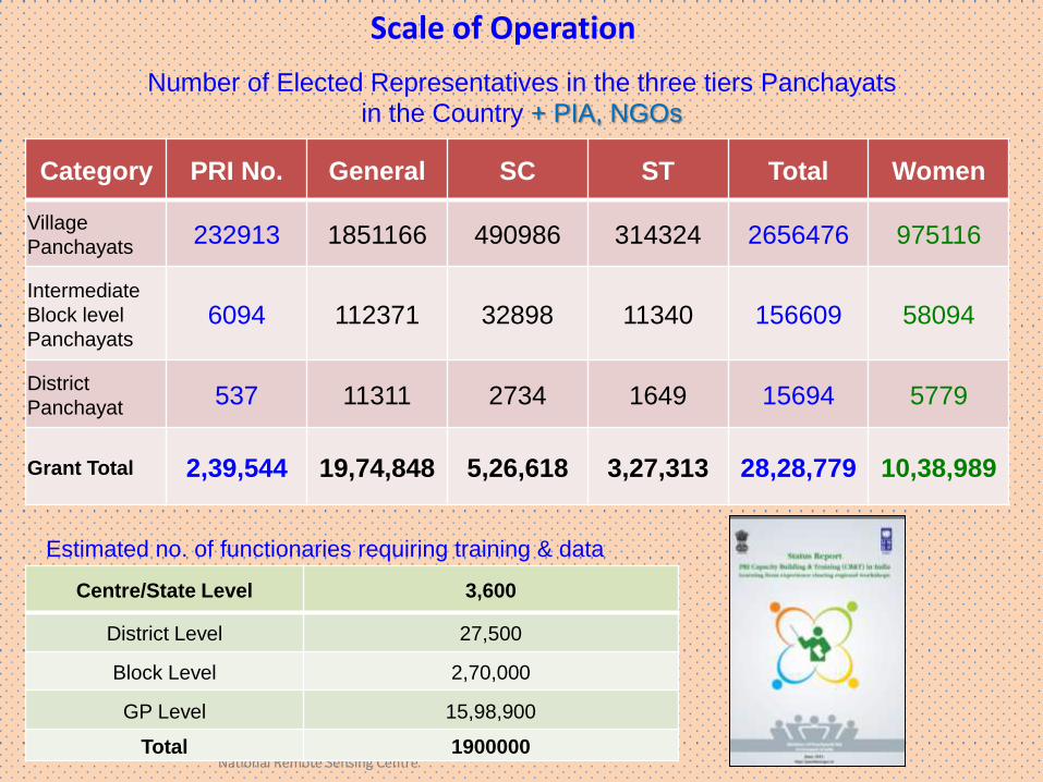
Scale of Operation
Number of Elected Representatives in the three tiers Panchayats in the Country + PIA, NGOs
Category PRI No. General SC ST Total Women
Village
Panchayats 232913 1851166 490986 314324 2656476 975116
Intermediate
Block level
Panchayats 6094 112371 32898 11340 156609 58094
District
Panchayat 537 11311 2734 1649 15694 5779
Grant Total 2,39,544 19,74,848 5,26,618 3,27,313 28,28,779 10,38,989
Centre/State Level 3,600
District Level 27,500
Block Level 2,70,000
GP Level 15,98,900
Total 1900000
Estimated no. of functionaries requiring training & data
Thank you
Space Inputs, Spatial Enablement
and G - Governance