Embed Size (px)
Citation preview
DOCUMENT RESUME
ED 391 747 SO 025 928
AUTHOR White, Barbara Jo; Sheffield, Elise SpruntTITLE The World Map Project Handbook.INSTITUTION Peace Corps, Washington, DC. Office of World Wise
Schools.REPORT NO ISBN-0-16-042642-1; WWS-23T-95PUB DATE 95
NOTE 80p.; Based on "The World Map Project Manual" byBarbara Jo White.
AVAILABLE FROM U.S. Government Printing Office, Superintendent ofDocuments, Mail Stop: SSOP, Washington, DC20402-9328.
PUB TYPE Guides Classroom Use Teaching Guides (ForTeacher) (052)
EDRS PRICE MF01/PC04 Plus Postage.DESCRIPTORS Area Studies; *Cartography; Elementary Secondary
Education; Geographic Location; Geographic Regions;*Geography; *Global Education; Locational Skills(Social Studies); *Maps; *Map Skills; Social Studies;Topography
IDENTIFIERS Peace Corps; World Wise Schools
ABSTRACTThis handb ok can be used by anyone with an'interest
in mapmaking. The sten-by-step guide shows how to draw, plan, andcolor a one-of-a-kind world map. There is a list of materials,supplies, worksheets, and a trouble-shooting appendix for specialsituations. The guide also provides a variety of enrichmentactivities to promote continued involvement with the world map. Theactivities stress cooperative problem-solving for participants of allages. There.are three parts in the guide: (1) "How to Make Your WorldMap"; (2) "How to Use Your World Map"; and (3) "Resources for MakingYour World Map." An appendix containing directional material and abibliography is also included. (EH)
***********************************************************************
Reproductions supplied by EDRS are the best that can be madefrom the original document.
**********************************************************************
.3,17p
U.S. DEPARTMENT OF EDUCATIONOffice Ot Educational Reseetch and ImprovementUCATIONAL RESOURCES INFORMATION
CENTER (ERIC)This document has been reproduced asreceived from the person or organizationoriginating it.
0 Minor changes have been made toimprove reproduction quality.
UI Points of view or opinions stated in thisdocumont do not necessarily representofficial OERI position or policy.
irwsn.s. . - -- .
"PERMISSION TO REPRODUCE THISMATERIAL HAS BE N ANTED BY
TO THE EDUCATIONAL RESOURCESINFCIRMATION CENTER IERICI"
_dr
For %ale by the 11.S. Government Printing Office
Superintendent of Documents, Mail Stop: SSOP, Washington, DC 20.141,1-9128
ISBN 0-16-042642-1
The World Map Project
Peace CorpsOffice of World Wise Schools
4
Based on The World Map Project Manual by Barbara Jo White
Expanded by:
Edited by:
Layout:
Published 1995
Elise Sprunt SheffieldReturned Peace Corps Volunteer, Lesotho (1985-87)
Mary KollerMargaret Legowski
Mary Koller
Peace CorpsWorld Wise Schools1990 K Street, N.W.Washington, DC 20526
This map uses the Robinson Projection.
This study guide contains materials written by educators and others thatrepresent their individual views. These views are not official opinions of theUnited States government or of Peace Corps.
WWS 23T-95
About this HandbookThe World Map Project brings people together to create large, colorful maps of the world.Initiated by a Peace Corps Volunteer, this project promotes geography literacy in an engagingway while also building a sense of community among mapmakers. It is one example of howVolunteers meet the goals of their Peace Corps service.
Since 1988, enthusiastic Volunteers have carried this highly acclaimed program to over 40countries around the world. Returned Volunteers have spread the idea across the U.S. as .-911.
Because of the wide appeal of the acti vity, this guide (a revision of an earlier manual) has beenwritten for many different groups. U.S. teachers, Peace Corps Volunteers, Returned Peace CorpsVolunteers, scout leaders, youth workers, and others.
You do not need to be a skilled cartographer: this guide gives you all the information you need tocreate your own one-of-a-kind world map. Inside you'll find step-by-step instructions on how toplan, draw, and color your map. This handbook also lists materials, supplies worksheets, andeven includes a trouble-shooting appendix for special situations.
The guide also provides a variety of enrichment activities to promote your group's continuedinvolvement with the world map. These activities stress cooperative problem-solving and arefor participants of all ages. You do not need to be a classroom teacher to introduce themsuccessfully. All activity plans list materials, provide instructions, and, if needed, supplybackground information. If you are part of the World Wise School program, you'll also findsuggestions for using the map to enhance your Peace Corps connection.
Whatever your group, wherever you are, World Wise Schools welcomes your participation inthis exciting worldwide project. As always, we also invite your comments and suggestions; yourideas are important to us. Happy mapmaking!
6
Table of Contents
The World Map Project: 10 Questions 5
Part I: How to Make Your World MapGetting Started 9
The Grid Methorl- 10Setting up Your Grid 10Drawing Your Map on the Grid 16
The T.'rojection Method 17Coloring the Map 18Labeling thc Map 20Celebrating the Map's Completion 21Keeping the Map Current 21
Part II: How to Use Your World MapActivities Before arid During Mapmaking: 23
How World Wise Are You? 23Create Your World 24Drawing by Grid 26Changing the World 27
Activities for a Completed World Map- 29Musical Countries: A Game 29What Shape Am I? 30We are the World 32Made In. 34World Watersheds 36Math and the Map 38
Part III: Resources for Making Your World MapThe World Map 41World Map Section Sheets 42World Map Color Scheme 56Practice Exercise #1: Enlar,;ing Drawings by Grid 63Practice Exercise #2: Dra wing Maps by Grid 64
AppendixHow to Draw Your Grid on Walls 67How to Draw Your Grid on Floors, Playgrounds and Other Flat Surfaces 69How to Make a Tissue Paper World Map , 70Bibliography 71How to Access World Wise Schools Materials 73
The World Map Proje.:t Introduction
The World Map Project: 10 Questions
How did the World Map Project get started?Back in 1988, Peace Corps Volunteer Barbara Jo White was waiting for a bus in the DominicanRepublic when she got an idea. Getting kids interested in geography was tough withoutmaterials, so why not paint a map of the world straight on the wall? With the approval ofschool authorities, Barbara Jo and her students set to work. From there the project blossomed.Soon the brightly colored maps adorned the walls of over a hundred schools in the DominicanRepublic.
Within two years, Peace Corps Volunteers had introduced the Project to communities around theworld. Back home, Returned Volunteer groups adapted Barbara Jo's original manual to share theidea with U.S. teachers. Interest in the project kept growing. Former President Jimmy Carterpublicly commended it. Corporations lent support too, including IBM, which has promoted theproject in all its "adopt-a-school" programs in Atlanta.
Today the World Map Project has spread to hundreds of cities, towns, and villages across theglobe. Many of the hand-painted maps brighten the walls of schools and community buildings.Others hang in classrooms, gyms, and cafeterias. At least one canvas map roams the U.S. on tour,courtesy of the postal service. Perhaps one day soon we'll find these beautiful maps in nursinghomes, libraries, and other public spots--not to mention the playground!
Why the big interest in the World Map Project?First, the maps are fun to make. They instill pride in accomplishment and boost confidence.They encourage cooperative problem-solving and build community. Just as important, they sparkexcitement in learning about the world everybody shares.
Who can do this Project?The Project is for everyone. Mapmakers of all ages and abilities have had success: deaf childrenin Ghana, school students in Thailand, youth groups in Tunisia, 4-H'ers in North Carolina,Returned Volunteers in Oregon, at-risk kids in Atlanta. There's room for your group, too.
How big can we make our map?The world map is adapted with permission from one created by the National Geographic Societyusing the Robinson Projection. rhe length of this map is twice its height. This means your mapcan be any size (metric or U.S. standard) as long as it retains this 2:1 ratio of length to height.Most groups have made maps at least 6 ft. x 12 ft. Mapmakers in Atlanta created one measuring15 ft., 2 in. x 30 ft., 4 in. There are rumors of an even larger one in Kenya...
Help! I can't drawl How can we make such a big map?This guidebook gives you two ways to make your map, and you don't have to be a I ,eonardo foreither one. The Grid Method lets you transfer information from pre-gridded map sheets onto justabout any surface. To do so, you first draw a big grid on your background surface. Then you copysections of the smaller map onto your larger grid one square at a time.
Almost everyone has drawn the world maps using the Grid Method, but you might want to makeyour world map using an overhead projector and a single world map transparency. The ProjectionMethod lets you trace a projected map image directly onto a wall without making a grid.
Peace Corps 5 World Wise Schools
The World Map Project Introduction
What should we use for our background surface?Walls are very popular: plaster, dry wall, cinder block, wood, or even brick. You can tiy floorsand playground blacktops too! Some mapmakers have opted for non-fixed surfaces like sheets ofpre-cut plywood, particle board, cardboard, or heavy plastic. (Draw your map on a single pieceor try a series of panels.) Still others have created their maps on canvas, cotton sheets, evenpieces of heavy paper taped together. (Businesses that sell vinyl flooring may be able to donatevery large pieces of heavy paper that come rolled with the flooring.)
Note: You may want to work with pre-cut surfaces whose corners are already squared (e.g.,sheets of plywood, pre-cut canvas, etc.) as these will be the easiest to construct your grid on. Ifyour surface isn't already square, don't worry! This guide tells you how to work with thesesituations too.
How should we color our map?Most mapmakers have painted their maps with acrylic or latex (water-based) house paint. (Fora 6 ft. x 12 ft. map, all you need is about 4 ounces of 8 paint colors, plus a quart or more of oceanblue, a white/blue mix.) Depending on your background surface (and stamina), you can also usecolored markers, colored pencils, or crayons. Some schoolchildren in Georgia have even madebeautiful maps from colored tissue paper strips.
As for coloring your countries, use the color scheme suggested in this guide, or make up your own.If you like the challenge of designing your own color scheme, you will need at least four colors;the more colors you have, the easier it is. Remember, light colors will show map labels easierthan dark ones. In assigning colors to various nations, keep in mind that countries and theirterritories are the same color. Thus, if England is green, so are the Bermuda Islands and theFalkland Islands. Therefore, the U.S. can't be green, or the Bermuda Islands would appear to beterritories of the U.S.
How long will it take us to make our map?It's best to take your time; this project is as much about process as product. Some groups havecreated their map in one intensive weekend. For others, the project evolves over several months.Each map is unique. Each has its own history. Relax: the learning is in the journey.
How much will it cost us?Not much. This is a very low-cost project. If you make a wall map, all you need is pencils, paint,and brushes. Expect to spend a bit more to purchase background surfaces like plywood, paper, orcanvas. Involve your community when gathering your resources--remember businesses, the PTA,civic groups, friends, and interested observers. You can also turn your project into a fund-raiser--take pledges or sell country tickets.
Can we improvise or make the map differently than the method suggested?Sure. Use your imagination. Try unusual materials. Depict physical features instead ofcountries. Create maps of your region. You can even apply your draw-by-grid skills to otherprojects like making posters and murals!
9
Peace Corps 6 World Wise Schools
Part I: How to MakeYour World Map
PROJECTION METHOD
Project Overview
rMake four dedsions.
Prepare materials.
4--
Make a transparencyof the map.
Trace map projectedon wall.
Make your map.
----4Color your map1
1
Label your map.
______+
1---CELEBRATE!
GRID METHOD
Construct a grid:Determine block size.Draw grid box.Make sure the grid is
squared.Draw grid lines.Number and letter
the grid.
Draw map on grid.
I 1
The World Map Project How to Make Your World Map
Getting StartedMake Four Decisions:1. Which mapmaking method will you use--grid or projection? (See p. 5)
2. Approximately what size will your map be? Any border? (See p. 5)
3. What background surface will you use? (See p. 6)4. How will you color your map? (See p. 6)
Prepare Your MaterialsPrepare Your Map Section Sheets (p. 42-55).
Each gridded sheet represents a section of the world map. If you make your world map using theGrid Method, you'll need these sheets when drawing, coloring, and labeling. In preparation:
Photocopy each section sheet (p. 42-55) to make single-sided copies.
Color the countries on your photocopied section sheets according to your c( 3r. scheme
(p. 56-62). Tt.'s usually easier to draw from colored map sections. Colored sheets alsoelimirmie endless "What-color-do-I-paint-this-country?" questions later on. Remindyour mapmakers to color lightly over written information. Double-check the results.
Protect the section sheets. Plastic-covered pages will last through many maprnakingsand paint spills. Laminate them or slip them into plastic folders and tape shut.
Prepare Your Background SurfaceAll surfacesYou'll want a background surface that is as clean, smooth, and as light-colored as possible. Ifyou'll be painting your map, make sure your surface is non-porous. Prime it, if necessary, and let itdry. Paint the entire map area ocean blue, two coats if needed. With ablue background, youwon't have to carefully paint the ocean around the continents and islands /ater on. Save someocean blue paint for touch-ups. (General recipe: ocean blue = 1/2 quart of white + 3-5 teaspoonfulsof blue.)
CanvasUse pre-coated artist-type canvas if possible. If your canvas is not pre-coated, you'll need toprime it with whatever product an art supply store recommends. Primer may seep through yourcanvas, so protect your floor. Also, keep in mind that linen canvas may shrink after getting wet.
Think about how you'll display your canvas once it's painted. Though not necessary, you maywant to consider stretching your canvas on a frame before priming and/or painting. Doing so willsmooth and "square" the surface as well as provide an attractive w ay to display the completedmap. After constructing your grid, take the canvas from the frame if you will be working on thefloor. Re-attach at the end of the project.
Another option is to lash the canvas to PVC plastic tubing, or sew a "pocket" the length of thecanvas through which you can later insert a strong rod.
Paper and CardboardYou can prime paper for an improved painting surface (see Canvas, above).
Floors and PlaygroundsSweep and hose down your surface so that it is clean. Depending on the size of your map, you maynot want to paint the entire area ocean blue.
Peace Corps 192 World Wise Schools
The World Map Project How to Make Your World Map
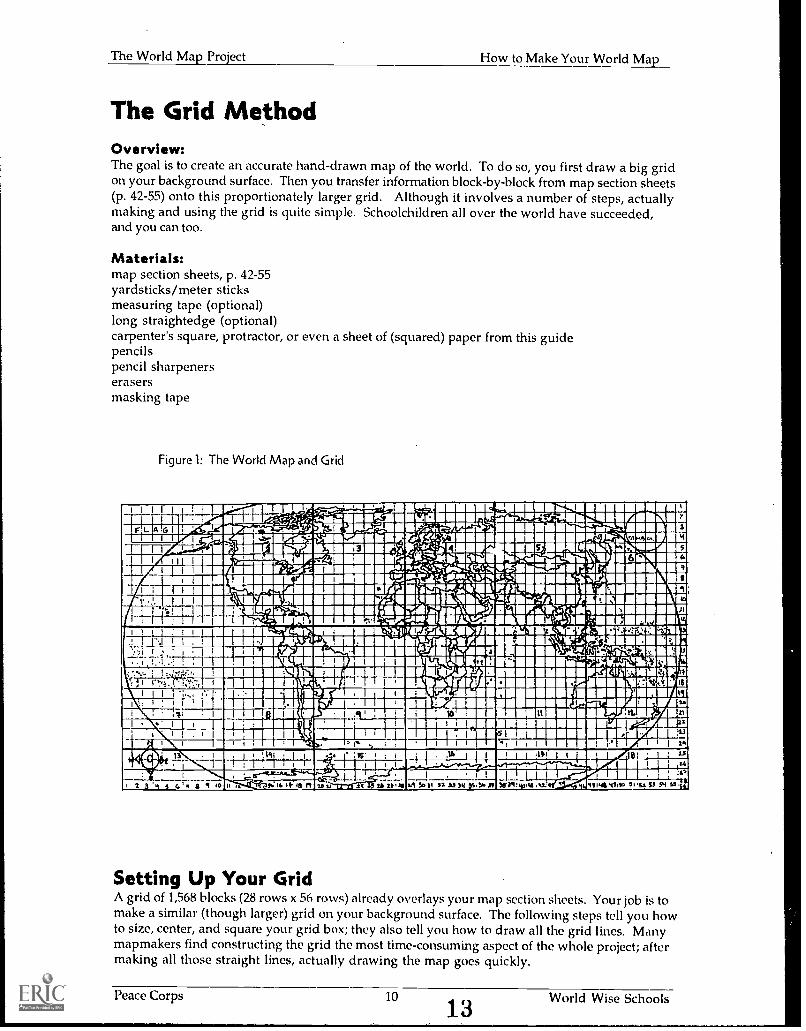
The Grid MethodOverview:The goal is to create an accurate hand-drawn map of the world. To do so, you first draw a big gridon your background surface. Then you transfer information block-by-block from map section sheets(p. 42-55) onto this proportionately larger grid. Although it involves a number of steps, actuallymaking and using the grid is quite simple. Schoolchildren all over the world have succeeded,and you can too.
Materials:map section sheets, p. 42-55yardsticks/meter sticksmeasuring tape (optional)long straightedge (optional)carpenter's square, protractor, or even a sheet of (squared) paper from this guidepencilspencil sharpenerserasersmasking tape
Figure 1: The World Map and Grid
I I I I 1 l I
,,,ivi5.4:44111:
Ei
I ,!:?...9---, ---me(
a/ re 65 1_.%:41_11.411111.11,_vriociTI
----- .._wcuummmilir -elimmgmall7Prili:gi IS ffill rmr-111111111111RE NM IlinntZTIMISE
-1---7--...smAGI. .4_111/111-aia#631r11.9"_,-.I im m o rd i pram
INFOURNMEI1111111P5'-grAi,11111111111fraiii*.:-,41111106insio-lirrwilillitIVIP111113iiMINC
Wakipilifel11111.4TIVINMWRIPAt Ei-----FrAlicilllill;14111111111111111,_,MIIRMIIIiIIII=Ideitire.V.I.;
l'WliIIPlANI,,,.
wIlltera111111=1117214117174,-WilbsrMalrIVITAIIMIIIIIiillni
CA 11111T2WeivatillITISMIIIIIIFEI.,..., L.
FpLj
++4Li...1_,
I 1
'1711111111,3111111111111111,11
likri4=11111111111011:111brgillit'famellIRIIIMMAIKiiihnIUMMI1111111111mm..,.imeoriRi3ii.:monflitMAIIIMMImt-mll-^71111%
I
,V11191111111.41kAWT.L.-IriatiIlUgalik-tt-. Illiailllar/iff.F.P.Manan.t.
..reouresuktiktifibitsrflommumak\
MAINIUMMIWIFWelliiialIzelag
Mil
11441TPS1011C111114111111111131UILMETA.111111MMII
MEl' 10111.111111bMilaTillatiMPLIMILVMit
1111.11111B11.r; 'Ar'a:WIThlig.
101411111,11111Bill11111111111., IMMO,'ACOIMilliltaril
VerdltaliS IIMOINEIIIMINWESINOME11111111111111,111111111111111111WEIam. ......m...nrawaimc
J..-- ! I ,:.1-L,7,. IIIRMIUMMIIIIMONIIMEREMINAKIIMILI111
f:TT-F;i. 1"7:"..:,I 1 i , .;...
! :: i glio . MINUMMIIMGWVIS
1 I:Mil ; : 1 INI 111111111MEAHMarItti 1-1-. ="NM- MININIUM.mrillire 23
nal:ow
.. r. u l 14e: ...im
4 .0
. , , ,. . 1 1 ,. ;IS' i Wlaquinnimiammo-7-M 1 1 II IMRE 1 1
' I mosimaittilaraUZIEMEICI ID u ... 1112m3R 5031
_,2-11041.41411155
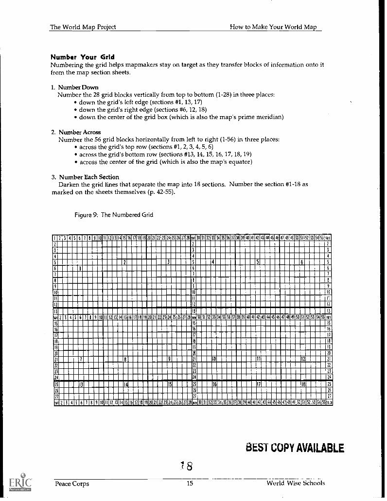
Setting Up Your GridA grid of 1,568 blocks (28 rows x 56 rows) already overlays your map section sheets. Your job is tomake a similar (though larger) grid on your background surface. The following steps tell you howto size, center, and square your grid box; they also tell you how to draw all the grid lines. Manymapmakers find constructing the grid the most time-consuming aspect of the whole project; aftermaking all those straight lines, actually drawing the map goes quickly.
Peace Corps 10
13World Wise Schools
The World Map Project How to Make Your World Map
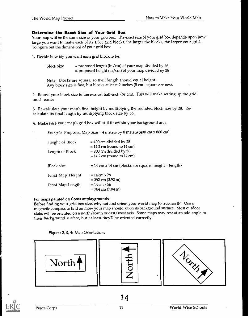
Determine the Exact Size of Your Grid BoxYour map will be the same size as your grid box. The exact size of your grid box depends upon howlarge you want to make each of its 1,568 grid blocks: the larger the blocks, the larger your grid.To figure out the dimensions of your grid box:
1. Decide how big you want each grid block to be.
block size = proposed length (in/cm) of your map divided by 56= proposed height (in/cm) of your map divided by 28
Note: Blocks are square, so their length should equal height.Any block size is fine, but blocks at least 2 inches (5 cm) square are best.
2. Round your block size to the nearest half-inch (or cm). This will make setting up the gridmuch easier.
3. Re-calculate your map's final height by multiplying the rounded block size by 28. Re-calculate its final length by multiplying block size by 56.
4. Make sure your map's grid box will still fit within your background area.
Example: Proposed Map Size = 4 meters by 8 meters (400 cm x 800 cm)
Height of Block
Length of Block
Block size
Final Map Height
Final Map Length
= 400 cm divided by 28= 14.2 cm (round to 14 cm)= 800 cm divided by 56= 14.2 cm (round to 14 cm)
= 14 cm x 14 cm (blocks are square: height = length)
=14cmx 28= 392 cm (3.92 m)=14 cmx 56= 784 cm (7.84 m)
For maps painted on floors or playgrounds:Before finding your grid box size, why not first orient your world map to true north? Use amagnetic compass to find out how your map should sit on its background surface. Most outdoorslabs will be oriented on a north/south or east/west axis. Some maps may rest at an odd angle totheir background surface, but at least they'll be oriented correctly.
Figures 2, 3, 4: Map Orientations
Northt
1 4
Peace Corps 11 World Wise Schools
The World Map Project How to Make Your World Map
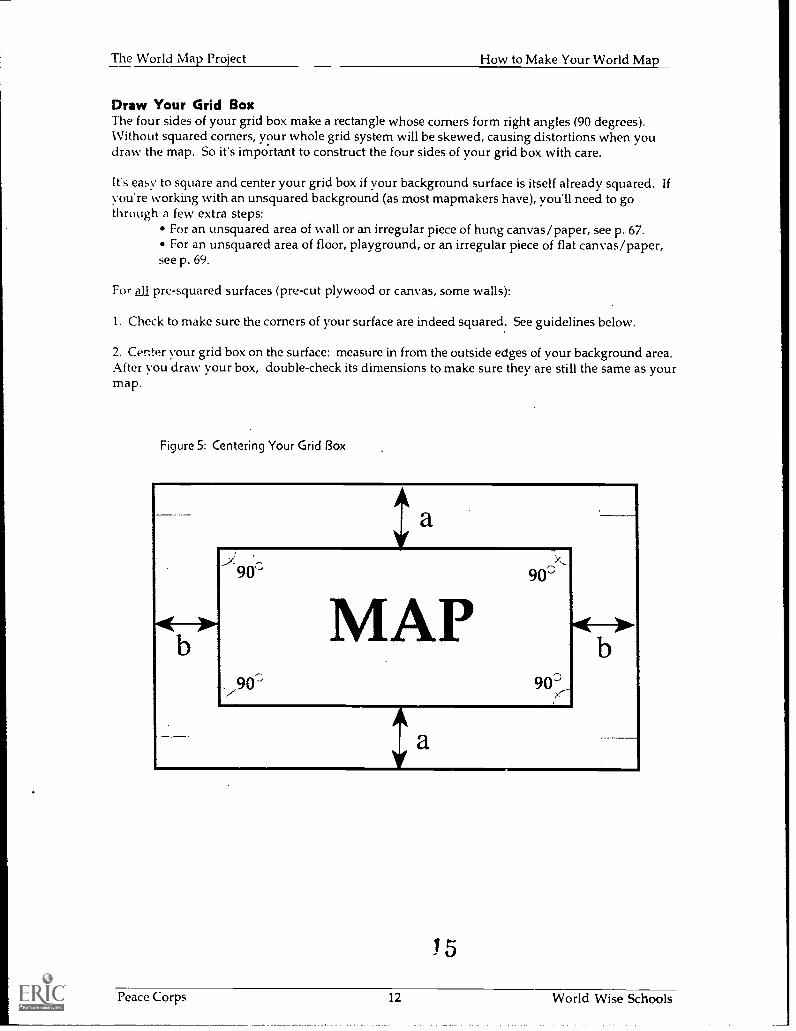
Draw Your Grid BoxThe four sides of your grid box make a rectangle whose corners form right angles (90 degrees).Without squared corners, your whole grid system will be skewed, causing distortions when youdraw the map. So it's important to construct the four sides of your grid box with care.
It's easy to square and center your grid box if your background surface is itself already squared. Ifyou're working with an unsquared background (as most mapmakers have), you'll need to gothrough a few extra steps:
For an unsquared area of wall or an irregular piece of hung canvas/paper, see p. 67.For an unsquared area of floor, playground, or an irregular piece of flat canvas/paper,
see p. 69.
For all pre-squared surfaces (pre-cut plywood or canvas, some walls):
1. Check to make sure the corners of your surface are indeed squared. See guidelines below.
2. Center your grid box on the surface: measure in from the outside edges of your background area.After vou draw your box, double-check its dimensions to make sure they are still the same as yourmap.
Figure 5: Centering Your Grid Box
a
9 900
MAP//90 90'
a
15
Peace Corps 12 World Wise Schools
The World Map Project How to Make Your World Map
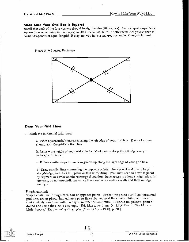
Make Sure Your Grid Box is SquaredRecall that each of the four corners should be right angles (90 degrees). An L-shaped carpenter'ssquare (or even a plain piece of paper) can be a useful tool here. Another test: Are your corner-to-corner diagonals of equal length? If they are, you have a squared rectangle. Congratulations!
Figure 6: A Squared Rectangle
Draw Your Grid Lines
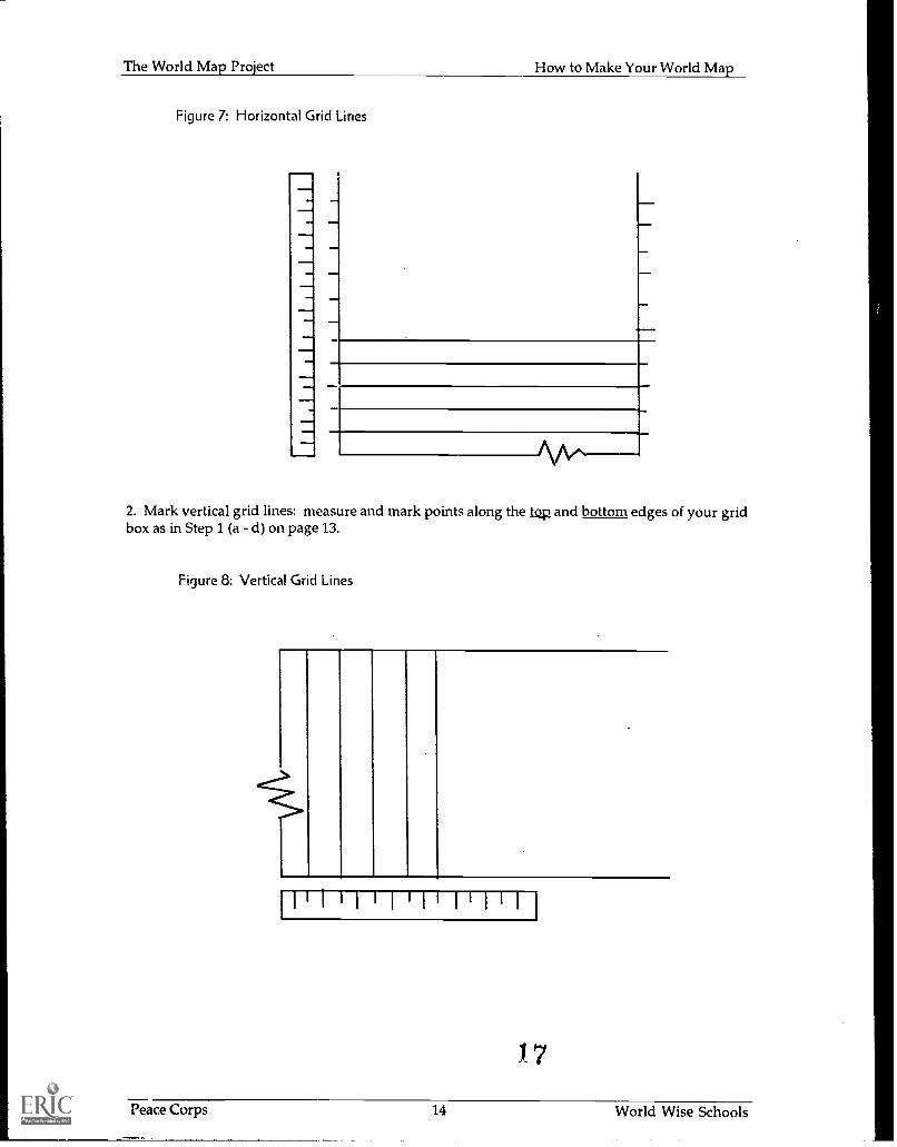
1. Mark the horizontal grid lines:
a. Place a yardstick/meter stick along the left edge of your grid box. The stick's baseshould abut the grid's bottom line.
b. Let n = the height of your grid's blocks. Mark points along the left edge every ninches/centimeters.
c. Follow similar steps for marking points up along the right edge of your grid box.
d. Draw parallel lines connecting the opposite points. Use a pencil and a very longstraightedge, such as a thin plank or taut wire/string. (You may need to draw segment-by-segment or devise another strategy if you don't have access to a long straightedge. Inany case, do not use chalk lines since they don't work well for walls and they smudgeeasily.)
For playgrounds:Snap a chalk line through each pair of opposite points. Repeat the process until all horizontalgrid lines are in place. Immediately paint these chalked grid lines with white paint, as youcould quickly lose them within a day to weather or foot traffic. To speed the process, paint adotted line using the side of a sponge. [This idea came from: David W. David, "Big Maps--Little People," The Journal of Geography, (March/April 1990), p. 60.1
1 6Peace Corps 13 World Wise Schools
^/1
The World Map Project How to Make Your World Map
Figure 7: Horizontal Grid Lines
2. Mark vertical grid lines: measure and mark points along the top and bottom edges of your gridbox as in Step 1 (a d) on page 13.
Figure 8: Vertical Grid Lines
>>
I I 1 1 1 ' 1 1 ' 1 1 1
1 7
Peace Corps 14 World Wise Schools
. . -
:0v
SOa,. S
.
II ^ : .
. a a . - a 4 : - a -
1111110E1 6 OULEIMMIUMEDIEDMIEMMEMMIEDE 30 ENSEIESIE13 36 m lam 40 BERICIEMMEMERMIIBERIMI1111111111111111111111MIIM11111111111111111MMEMINIM1111111111111 11111111111111111111111111111111111DIIIM1111111111111111111111111111111M111111111101111111111111111111IMIE111111O 111111111111MIIIIIIIOMMIIIIMIIMMINEEIIIIIMEM1111111111M1111111111111111111111111MIIIIIIIMIMMIUMMIIIIIIIMIUMIIMEMMINIIIII11111111111111111111 6 1111111111INIIIIIIIM11111111111111111111111111111MIIMIN11111111M1111111111111MI111001111111111111111111M1111111111111111111111111111111M11111111M111111111=111111111111111111101111111111 IIIMMIMIE11111111EINIIMIIIMINNE111111111111111111MMINNEMIRMIIIIIIM1111111MINIMEN111111111110O 11111111111111111111111111111111111111111111111111111111111111111111111111MMIIIIIIIIHMEMINNIEU13111INIMIN11111111111111111111MMIIIIIIIIMM1 10 111111.111111.111111.1111NEMEMINEINIB11111111111111111111111111111111111INNIIIIIMMMEHNIIMEMIIIIIMIIIIIIMIMI111191111111111111M1111111011=1111111M111111111011101111111111111111111111111111111111111111111111111131111II1IIIIIIMIII1IIIIIIIIIIIIIII1INIUM1111111111111111111110111111M1111111111111111111111E1EI11ERIEMUEIE1 10 11111=10113fflinle 20 81111EI1EMEDEE 30 Eilallg11213310031 40 orsoCIENE9 43 SO MEMO101111111111111MMENENNHI11111111111111111311111111111111IMEMMINMIIIIM11111MI111111111111111111111111111011111111111111MEIMIIIIIIIIIIIIIMIIIIIIIIIIMINIMININI1111111111111111111111111111111111111M1111111101111111111111111111111111NEMIEMEMIIIMIMIll111111NNIIIIIIIIIIIIIIIIIINUM11111111111111:1111IIIMMIIIIIMIN1111111111MINEIICIIIIIMMIMIIII1111111111111M1111111111M 13 11M111111111111111MEMMI11111111120 11M1111111111111111111IEMM11111111111 20 MMIINENMMIIIMIME1:111111111116111111111M1 e 11111111111111111 9 11111111161111110 111111111111111111111111111MI1E1111111161EE11111111111111M1111101111111111111111111131111011lu1111111111111111111111M1111113IMIIIIIIIIIMIIIIIIIIINI1111111111111111101111I111111111111IIIIIIIIIIIIIINIMIIMIIMMINME1111111111111111MIIIMIIIIIIIIIIIIIIIIEMIllmimiMIMIIMMEN111111111=111111EIIIIIIM111111111111[EIMIIMMENIIIIIINIIIMI is EMU IIMIERIMIIIIMINIII iesiniaNsimnmsumuimumniums 26 IIIIIMIINIIIIIIIIIIIMIIIIIIUNI111EillINIIIIIIMIIIIIMMIIMIIIMMIMENIIIIMIIIME11111111111111111111111111111111111MIN1311111111 6 11E1E1 10 INDEMMEMIEIM 20 IMEMEZIKIMIS. 30 1111IIMEIMEIM 40 EICEMBLISIM11101111111152
6
19
1 20
26
e
101
The World Map Project How to Make Your World Map
Drawing Your Map on the GridNow yOu are ready to draw the whole wide world! Although it sounds like a big undertaking,transferring information from the section sheets onto your grid is relatively straightforward--almost anyone can do it.
Materials:copies of Practice Exercise #1: Enlarging Drawings By Grid, p. 63copies of Practice Exercise #2: Drawing Maps by Grid, p. 64-5copies of map section sheets, p. 42-55pencils and erasers (most surfaces)chalk and wet rags (playgrounds)
Practice How to Drab/ by Grid1. Hand out Practice Exercise #1, p. 63. This worksheet gives your mapmakers a chance to honetheir skills. It also lets you know who among your group may need more assistance. Some people,
. especially young children, will have a harder time than others enlarging drawings. Those whoaren't particularly adept at map drawing, however, make wonderful map painters.
2. Hand out Practice Exercise #2, p. 64-5.
a. Remind mapmakers that the key to success is making sure country borders or coast lines crossthe large grid block in proportionately the same place as on the corresponding small grid block.
b. Discuss strategies for drawing difficult map areas:For complex borders, subdivide an especially challenging block into four smaller blocks.
Be sure to subdivide the same block on the large map grid as well.For numerous small islands, draw in a few of the larger South Pacific islands in each
island group (Tuvalu, Vanuatu, etc.). Using these islands as reference points, paint thesmaller islands directly on your surface.
Devise a strategy for working on the world map itself:1. How many mapmakers can work on each section?2. How many sections can they work on at one time?3. In what order will they draw these sections?4. Who will check the accuracy of each transferred section? How will it be done?
Drawing the MapTransfer information from the small map sections onto the corresponding sections of the largegrid. Copy block-by-block until you have completely drawn the entire map.
Very Important: When starting to draw in a new area, always check, double-check, and triple-check the coordinates on the section sheets with those on the large grid. Be sure that you begindrawing your country in the correct block. You may want to use paired teams to minimizeconfusion: one partner "navigates" (points to the correct block and checks the work) while theother draws. Encourage partners to switch tasks.
9
Peace Corps 16 World Wise Schools
The World Map Project How to Make Your World Map
The Projection MethodThis is an alternate way of drawing your map on a wall (or other vertical surface) using anoverhead projector. The Projection Method does not involve drawing a grid.
Materials:transparency of world map, p. 41copies of map section sheets, p. 42-55overhead projectorelectrical outlet and extension cordpencilspencil sharpenerserasersmasking tape
Steps:1. Make a transparency of p. 41.
2. Project the transparency onto your wall. Adjust the distance of the projector from the walluntil your map is the size you want. To prevent mishap, mark your chosen spot on the floor witha piece of tape.
3. Tape the transparency to the projector to prevent accidental movement. Also secure theprojector.
4. Devise a work strategy with your mapmakers:a. How many mapmakers can work at one time?b. Who will check the accuracy of the tracing? Are all countries accounted for?
5. Trace the projected map information onto the wall. Use pencils.a. First trace the large rectangle that frames the map, then the oval map itself.b. Now trace the interior lines separating the map into 18 sections. (Refer to Figure 1,p. 10.) Numbering sections 1-18 will be helpful when you refer to the section sheets forcoloring and labeling your map.c. Trace the continents before drawing individual countries.
6. Once you have completely traced the map, color and label it; see p. 18-20.
2 U
Peace Corps 17 World Wise Schools
The World Map Project How to Make Your World Map
Coloring the MapMaterials:your colored copies of the map section sheetslatex or acrylic paintcontainers for paint (screw-on lids sometimes stick)plastic spoons/cups (for mixing/stirring paint)brushes of a variety of sizes (small-tipped brushes will keep many painters busy)rollers an,!.. pans (for really big jobs)rinse water canssoap and water (for washing brushes)newspapers (for catching drips)paper towelsspongeslarge erasers for removing the ocean grid lines
Mixing ColorsIf you can't get ready-mixed colors, here are some recipes you may want to try. Except for oceanblue, which calls for a half quart of white, the others are measured in teaspoonfuls, as you needonly a small amount of each (depending on the size of your map, of course):
Ocean blue = 1/2 quart of white + 3-5 teaspoonfuls of blueGreen = 4 yellow + 2 blueLight Green = 7 yellow + 1 bluePurple = 4 red + 2 blueLavender = 5 white + 2 purplePink = 5 white + 3 redOrange = 5 yellow + 3 red
Mixing tipsColors need to be light so that map labels will show up. To prevent a color from becoming toodark, always put the light color in your cup first and add the darker color bit by bit. Alwaysshake your paint before and after mixing for best consistency.
Non-paint possibilities:wide-tipped colored markers (waterproof)colored pencils and sharpenerscrayonswhite cover-up for errorscolored tissue paper (see p. 70)
To color:1. Test your colors to make sure they cover your grid lines. If not, erase the affected grid lines.Light colors like yellow may not cover grid lines, even with 2 or 3 coats; mixing a little whitewith the color may help.
2. Pre-code country colors on the large map. Although mapmakers can consult the colored sectionsheets, facilitate the process further by putting an appropriate dot of color in each country. Thiswill eliminate questions and confusion while your group is coloring.
3. Decide how you'll color the background area surrounding your oval map, the corner emblems(optional), and a rectangular border (optional).
4. Alert mapmakers to any special care of materials, e.g. how to wash brushes.
Peace Corps 18 World Wise Schools
The World Map Project How to Make Your World Map
5. Devise a work strategy similar to the one you developed for drawing the map. Alternately,develop a job chart. Go over tasks and roles with your mapmakers. In addition to painters, you'llalso need map checkers and cleaner-uppers.
6. Paint your map:For best consistency, always shake your paint before using it.Alert painters to the "danger" of painting adjacent to a still-wet country. Colors could
mix at the border.If grid lines cross your oceans, erase the lines or touch up with paint.
Peace Corps 19 World Wise Schools
The World Map Project How to Make Your World Map
Labeling the MapMaterials:copies of map section sheets, p. 42-55straightedges (optional)pencils (optional)extra paint for touch-ups and correctionspermanent black markers (or brushes and paint for really big jobs):
wide-tipped for oceans, equator, large countriesmedium tipped for medium-sized countriesthin-tipped for small-sized countries
clear water-based finish (makes the painted surface smoother and easier to write on)
To Label:1. Prepare your map's surface for labeling, if desired. First brush or spray a thin coat of finish onyour map. When you've completed your labeling, add a second coat of finish. First test a smallarea to make sure that the product is compatible with the marker you used.
2. Decide what you want to label. Some possibilities:continentscountries and territorieslocation of capitalsbodies of water (oceans, seas, gulfs, bays, lakes)equatordetails on your emblems and on the compassnames of mapmakersdate of completion
3. Devise a work strategy:Who will do the labeling?What size(s \ will the labels be?Where, exactly, will the labels go?Who will check the accuracy of the labeling (spelling, position)? How will it be done?
How will errors be corrected?
4. Label: To minimize errors, labeler(s) may want to first write in pencil and then copy in ink.
23
Peace Corps 20 World Wise Schools
The World Map Project How to Make Your World Map
Celebrating the Map's CompletionCongratulations! You've finished! Why not hold a celebration to honor all those who helpedwith the map and to behold the beautiful result of all that collaboration?
Take a group photo in front of the map (and send World Wise Schools a copy) and call in thelocal TV crews or print media too.
Coincide your "world premiere with an event like Earth Day or Geography Awareness Week.Invite people from other countries to share song, dance, food with you, or call in some ReturnedPeace Corps Volunteers. They are happy to speak about personal experiences living and workingin countries around the world.
Other ideas: Try out some of the activities detailed in Part share slides or photos of the workin progress. Invite parents, classmates, community memberF, and others to write comments in aguest book. Have fun!
Keeping the Map CurrentThe world keeps changing. Your map can either be a "snapshot in time or a periodicallyupdated document. If you opt for "snapshot," do record the date of completion on your map. If youwant to keep the map current, keep abreast of political changes in our world. Create a file orcompare your map with an updated one. Schedule an annual "catch-up" day to make changes;hang on to your supplies.
24
Peace Corps 21 World Wise Schools
Part 11: How to UseYour World Map
The World Map Project How to Use Your World Map
Activities Before and During Mapmaking
How World Wise Are You?(all grades)
Time Needed:One session
Summary:Mapmakers measure increases in geographical knowledge: they identify countries and/or draw aworld map from memory both before an after the World Map Project.
Curriculum Link:geography: locations of countries/regions
Materials:pencilsunlined papercopies of a world map identification sheet
To prepare:1. Turn to the world map on p. 412. Number 10-20 countries/continents/seas, etc. on this map for participants to identify. Adjustthe level of challenge to the age and ability of your mapmakers.3. Make photocopies of this adapted map sheet. Participants can write their answers on thissheet--or devise a multiple choice answer sheet for them to use instead.
Steps:1. Briefly introduce the World Map Project and get feedback:
What kinds of things could we learn by doing this project?What could we specifically learn about geography?Is it important to know where countries are and what they are like? Why?How could we find out whether we have learned more about world geography by doing
this project?
2. Introduce the map identification sheet as one way participants can measure how much theyhave learned about world geography during the course of the project. If appropriate, encourageyour group to reflect on the strengths and weaknesses of this kind of assessment:
What could this kind of survey measure? (knowledge of specific facts)What couldn't it measure? (attitude changes, understanding of cultural, political and
economic realities in other countries. . .)Despite its limitations, how could this survey still be a useful tool for us?
3. Distribute the identification sheets. Ask individuals to complete the survey to the best oftheir abilities; remind them the assessment is not a test. In addition to (or instead of) using themap identification sheet, have participants draw and label a map of the world from memory.
4. Collect the completed sheets. Do not go over the surveys with your group at this time. Remindyour group they'll take the same survey (or draw another map) at the end of the project. Theywill then compare results of the two assessments to see how making the map affected theirknowledge of geography. At the end of the project, you might also ask mapmakers whether theyhave also noted other changes, such as increased interest in global issues and/or gains inconfidence.
Peace Corps 23 World Wise Schools
The World Map Project How to Use Your World Map
Create Your World(grades 3-9)
Time Needed:Several sessions
Summary:Mapmakers design and conduct a survey whose results help them plan the specifics of theirworld map-to-be. This activity encourages an early sense of project ownership amongmapmakers. Taking the survey to the community publicizes the World Map Project and creates awider circle of interest and support.
Curriculum Link:language arts: written and oral communicationmathematics: compiling, quantifying, and graphing data
Materials:copies of a world map survey which your group will depign during the activitygraph paper or pie charts to record survey data (optiokaj)chalkboard or flip chart
Steps:I. Inform your group they'll be designing a survey that will help them make decisions about howto make their map. Have group members identify some of the decisions they need to make abouttheir world map (see p. 5-6 for ideas). Record these questions on the chalkboard.
2. Work with your group to develop these questions into a brief survey similar to the examplebelow. Questions should have easily tabulated answers (e.g., yes/no), but consider asking anopen-ended question or two as well:
Example: "Were planning to make a really big world map. . ."
Do you think this is a good idea? yes/no (Why or why not?)Of the following locations, which is the best place for our map?Of the following colors, which 5 should we use to paint the countries?Of the following sizes, which size map would you like us to make?Would you like to help with this ..lroject? yes/no (In what ways?)
3. Have your group first survey themselves:Distribute copies of your survey.Have pairs survey one another.When everyone has been surveyed, record the results of the survey on a chalkboard or
flip chart.Have teams of 4-6 persons analyze specific portions of the survey data. (For example,
team #1 analyzes all the data about map color preferences). Charge each team tovisually represent that data using bar graphs or pie charts. Have them present theirfindings to the whole group.
4. Extend the survey process to your whole school or local community:Have each member in your group survey three or more people. Be sure to first discuss
survey etiquette. You may want community surveyors to travel in pairs, or with art adult;secure parental permission if necessary.
Compile the results by dividing the surveys among several teams. Have each teamcontribute its tabulations toward a whole group total. Record results on the chalkboard.
Now have teams analyze specific portions of the totaled data as in #2 above.
7Peace Corps 24 World Wise Schools
The World Map Project How to Use Your World Map
Have each team present its findings to the whole group. Compare the results of thislarger survey with the smaller in-group survey. Make preliminary project decisionsbased on the results of the survey(s).
5. Writing assignment: have group members do any of the following:Summarize their team's data or impressions in a paragraph;Compare/contrast the survey results: 1) between group teams, or 2) between the whole
group and the wider community;Draft a news release detailing the World Map decisions reached by your group; publish
it in the school or local newspaper--let your community know what you're up to!
2 8
Peace Corps 25 World Wise Schools
The World Map Project How to Use Your World Map
Drawing by Grid(all grades)
Time Needed:One session
Summary:Mapmakers practice drawing by grid in preparation for drawing countries on the world map.
Curriculum Link:mathematics: measurement, ratio and proportiongeography: shapes and locations of selected countries/regions
Materials:world map, p. 41 (opConal)map sections sheets, p. 42-55 (optional)copies. of Practice Exercise #1: Enlarging Drawings by Grid, p. 63copies of Practice Exercise #2: Drawing Maps by Grid, p. 64-5chalkboard or flip chart
Steps:1. Give a brief overview of the Grid Method. Mapmakers will quickly grasp the idea if youvisually demonstrate what you're talking about. Make a few simple sketches and show thegridded world map (p. 10) or map section sheets (p. 42-55).
2. Have mapmakers practice making an enlarged drawing by grid: distribute Practice Exercise#1.
3. Have participants specifically practice drawing map sections by grid: distribute PracticeExercise #2. Discuss strategies. See p. 16.
Peace Corps Connection:Have mapmakers draw a map of the Volunteer's host country using the Grid Method. You willneed to do some advance preparation: Obtain a simple map of the Volunteer's country, construct agrid on it, and make photocopies. Also make and photocopy blank grids to transfer the drawingonto. Have mapmakers locate the Volunteer's site on the map.
2 9
Peace Corps 26 World Wise Schools
The World Map Project How to Use Your World Map
Changing the World(grades 6-12)
Time Needed:One session for map work and one session for research
Summary:Participants note changes in political geography by comparing a section of the world mapagainst an earlier map of the same region.
Curriculum Link:language arts: written and oral communicationgeography: location of countries/regionssocial studies: political historyresearch skills
Materials:copies of world map section sheets or world map (if completed)out-of-date map resources (atlases, encyclopedia)--the older the bettercurrent encyclopedia
Background:The world keeps changing: the seas swell and recede, the continents drift, and land formsliterally rise and fall. Geological changes may be often imperceptible within one humanlifetime, but political change can be rapid. Nations too rise and fall, reshape borders, changenames, and gain new capitals. Because of these historical changes, mapmakers are constantly re-drawing the world. In this activity, participants will look for changes in the world's politicalgeography. For a tighter focus, you may want to adapt the lesson to address regions particularlyrich in recent change: Europe, Africa, and/or Asia.
Steps:1. As introduction, draw your group's attention to the dynamic nature of the world map. Discuss:
What type of information on the map could be considered unchanging? Why?What kind of information is subject to change? Why?
Inform your group they'll be looking for examples of how countries/regions on the world maphave changed over time. Can anyone give an example of a recent change in political geography?
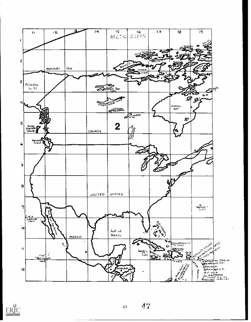
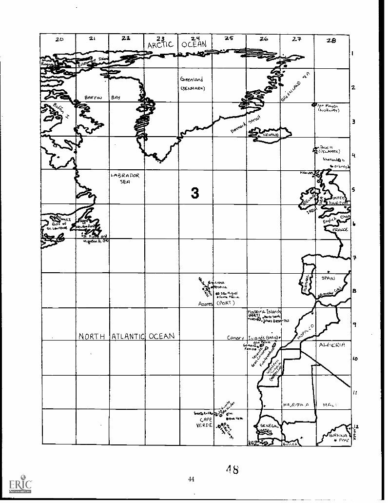
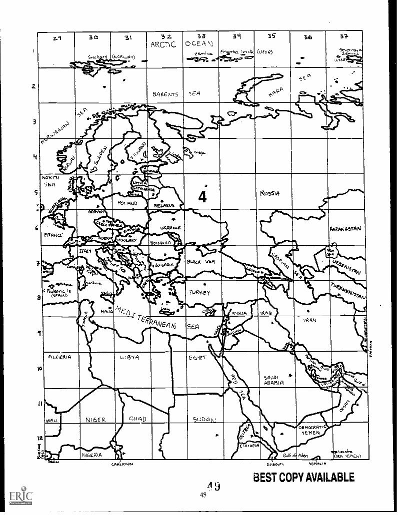
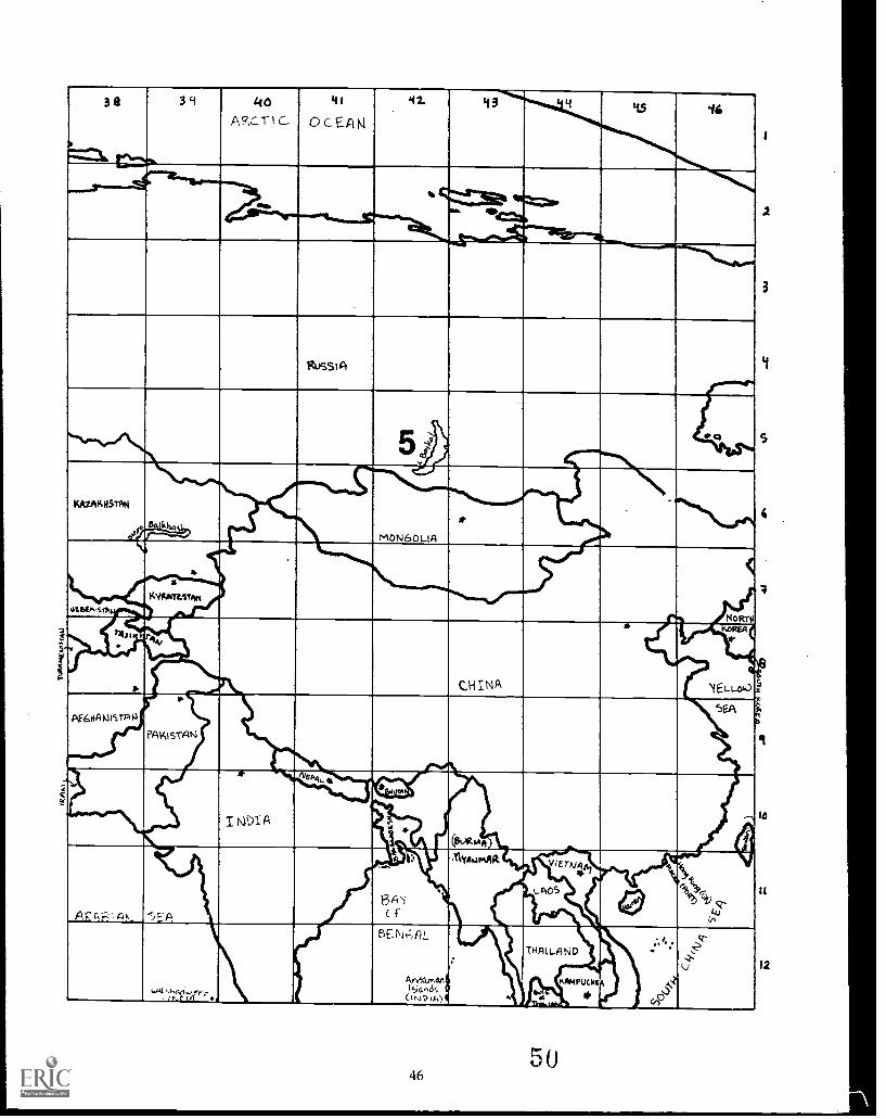
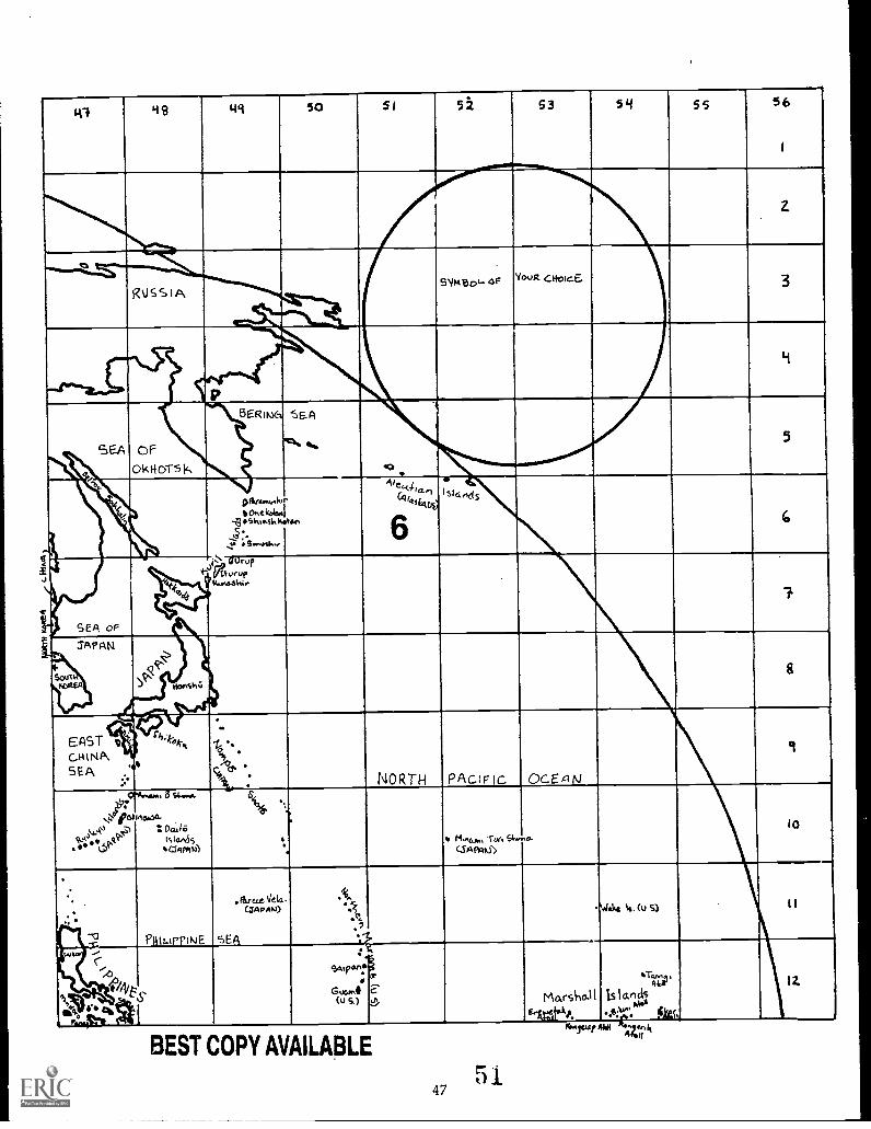
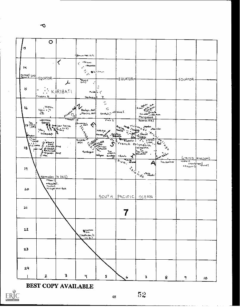
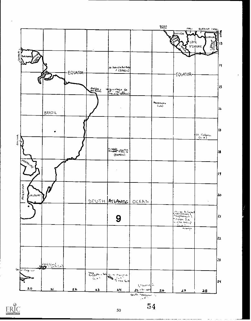
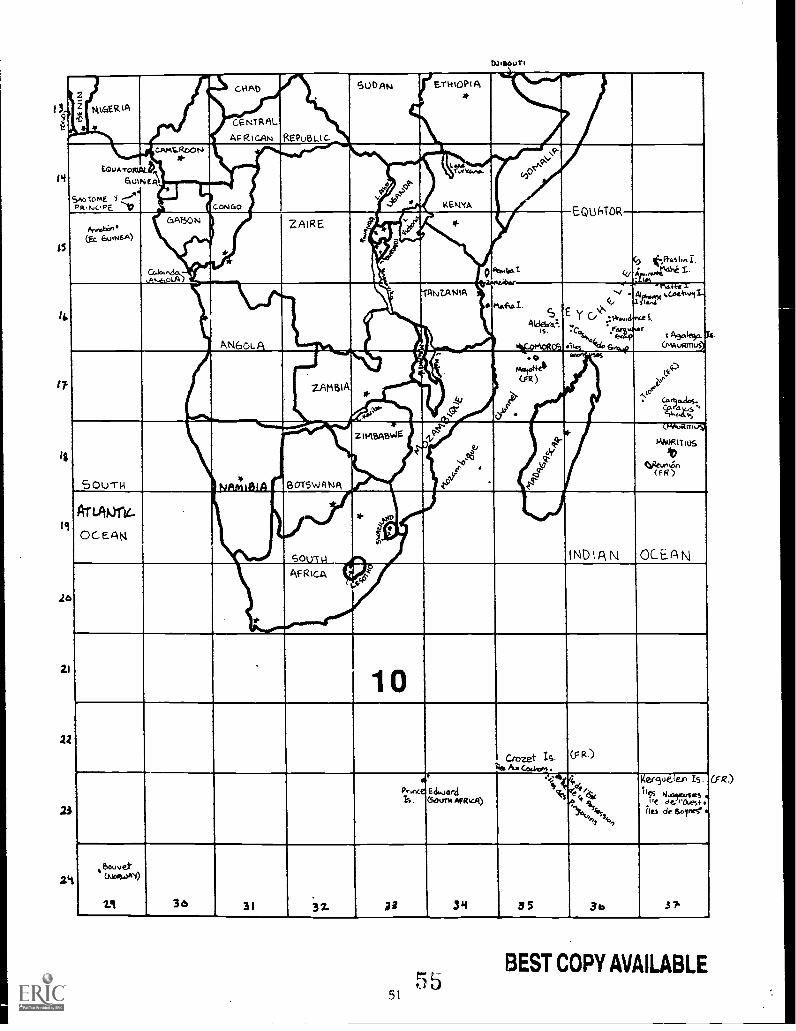
2. Divide regions of the world among teams of 2-4 persons. Assign specific section sheets to eachteam, as below, or make your own regional divisions.
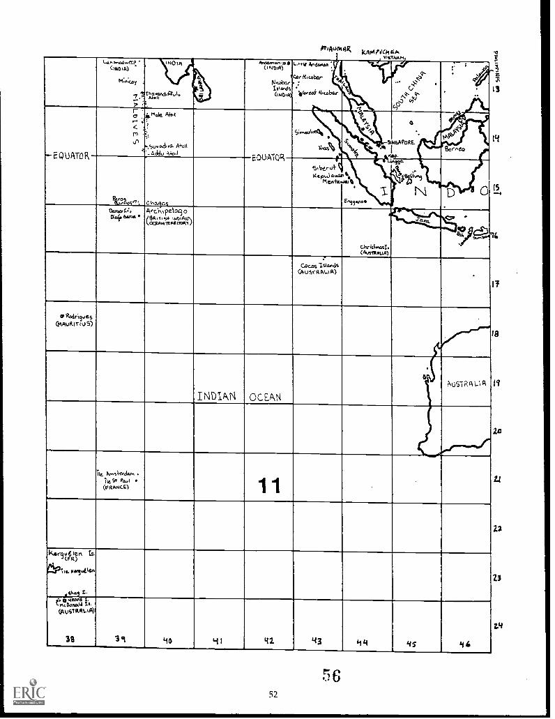
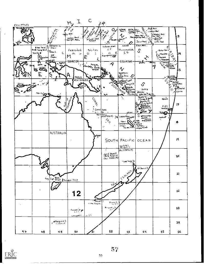
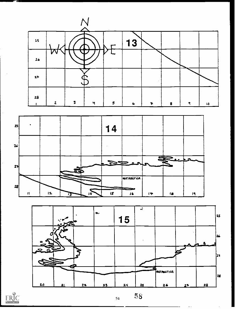
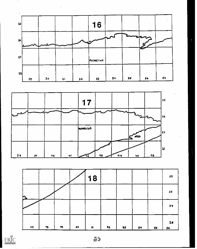
#2 (North America)#3 (North Atlantic)#4 (Eastern Europe)#5 (Asia)#6 and #1 (North Pacific)"#7 and #8 (South America)#9 and #14-17 (South Atlantic and Antarctica)#10 (A frica)#11 and #12 (India/Australia)
30
Peace Corps 27 World Wise Schools
The World Map Project How to Use Your World Map
3. Instruct each regional team to check the geographic information (borders, names of countries,capitals, rivers, etc.) on its map section(s) against an out-of-date map. Have team members notethe following:
What year was the resource you consulted published?What changes (if any) in borders, names of countries/capitals, etc. do you find since
that date?
Note: Your world map is drawn according to the Robinson Projection. The resource maps youconsult may represent other projections. The difference in projections may affect the shape ofland masses within a region. Greenland, for example, appears quite differently in the RobinsonProjection than on the Mercator Projection. Alert your group to this possibility.
4. Challenge your teams to find out the reasons for the specific changes in political geographythey discover; have them research the history of these countries or regions.
5. When research is complete, have teams share their findings with the whole group. Ask themto point out the changes on the world maps explaining reasons for those changes, if known.
Peace Corps Connection:Have your group pay particular attention to changes in the political geography of theVolunteer's host country or region. Encourage your group to share its findings with the Volunteer.Have group members ask the Volunteer to provide more detail, if possible, or to explain evenearlier instances of change in that nation's political geography.
31
Peace Corps 28 World Wise Schools
The World Map Project How to Use Your World Map
Activities for a Completed World Map
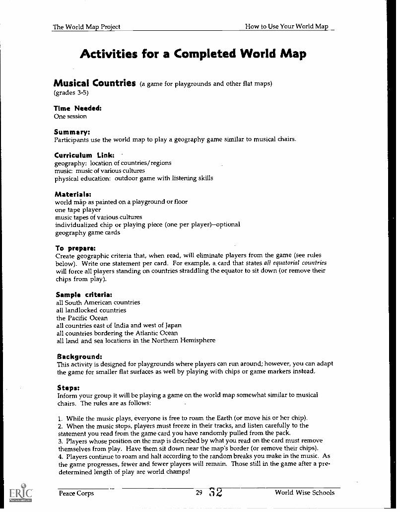
Musical Countries (a game for playgrounds and other flat maps)(grades 3-5)
Time Needed:One session
Summary:Participants use the world map to play a geography game similar to musical chairs.
Curriculum Link:geography: location of countries/regionsmusic: music of various culturesphysical education: outdoor game with listening skills
Materials:world map as painted on a playground or floorone tape playermusic tapes of various culturesindividualized chip or playing piece (one per player)--optionalgeography game cards
To prepare:Create geographic criteria that, when read, will eliminate players from the game (see rulesbelow). Write one statement per card. For example, a card that states all equatorial countrieswill force all players standing on countries straddling the equator to sit down (or remove theirchips from play).
Sample criteria:all South American countriesall landlocked countriesthe Pacific Oceanall countries east of India and west of Japanall countries bordering the Atlantic Oceanall land and sea locations in the Northern Hemisphere
Background:This activity is designed for playgrounds where players can run around; however, you can adaptthe game for smaller flat surfaces as well by playing with chips or game markers instead.
Steps:Inform your group it will be playing a game on the world map somewhat similar to musicalchairs. The rules are as follows:
1. While the music plays, everyone is free to roam the Earth (or move his or her chip).2. When the music stops, players must freeze in their tracks, and listen carefully to thestatement you read from the game card you have randomly pulled from the pack.3. Players whose position on the map is described by what you read on the card must removethemselves from play. Have them sit down near the map's border (or remove their chips).4. Players continue to roam and halt according to the random breaks you make in the music. Asthe game progresses, fewer and fewer players will remain. Those still in the game after a pre-determined length of play are world champs!
Peace Corps 29 32 World Wise Schools
The World Map Project How to Use Your World Map
What Shape Am I?(grades 3-9)
Time Needed:One session for map work and one session for research
Summary:Participants trace shapes of particular countries on the world map and discuss reasons for thelocations of specific borders.
Curriculum Link:geography: location, shape, and topography of selected countriessocial studies: political history of selected countriesresearch skills
Background:Physical factors such as rivers, mountains, and coastlines often form natural boundaries for acountry. Many times, however, a country's shape reveals as much about its history as itstopography. Human factors such as wars, treaties, ethnic demographics all influence borderlinestoo.
Materials:world mapsheets of tracing paper (or thin typing paper)cellophane tape (if needed)reference materials (topographical atlases, encyclopedia)colored pencils, crayons, or markerschalkboard or flip chart
Note.: You can adapt this activity for different ages and interests. Emphasize steps 1-4 foryounger groups, steps 4-7 for older groups.
Steps:1. Invite participants to join you in a hunt across the map for countries with interesting shapes.Many people see a boot and soccer ball when looking at Italy and Sicily; what do you see inCuba? Australia? Senegal? Encourage imaginative responses.
2. Divide participants into pairs and have each pair trace on paper one or two countries from theworld map whose shape is especially interesting to the two of them. Pairs may also want tocolor and/or decorate their traced shapes to illustrate what they resemble (e.g. , put eyes on acountry shaped like an animal).
3. When everyone is done, have pairs share their shapes with all or part of the whole group.What do we "see" in the shape of this interesting country?Who can identify this "mystery" country and/or locate it on the world map?
Variation:Invite pairs to share their shapes with the group without divulging the name and location of thecountry in question. After all shapes have been shared, distribute them to small teams.Challenge each team to work together to discover the name and location of each mystery country.
4. Re-focus your group's attention to reasons why countries have different shapes. Discuss:Why aren't all countries the same size?What causes countries to have different sizes and shapes?Do countries ever change shape? Why? Can anyone give an example?
Peace Corps 30n I
World Wise Schools
The World Map Project How to Use Your World Map
5. Have pairs (or individuals) find out why their chosen country has the shape it does. Havethem consult a topographical map of their country and also research its history.
While they may not find reasons for the location of every border, challenge your researchers toidentify as many factors as they can. For example, does a river or mountain range form thesouthern boundary; does a straight eastern edge suggest a political division? Encourageresearchers to write down their findings on their individual maps, near the borders in question.
6. Have pairs share their findings. Make a list on the chalkboard of the most common factorsinfluencing the placement of a country's borders.
7. Display everyone's labeled drawings next to the world map, if possible.
Peace Corps Connection:1. Have participants analyze the shape of the Volunteer's country in a way similar to step #5above. Make predictions about what caused the borders of this nation to be drawn where theywere. Share the predictions with the Volunteer.
2. You may also want to ask the Volunteer to describe the size/shape of his or her country at anearlier point in its history. Why is it no longer this shape? What impact, if any, have thesechanges had on the country and its people?
3 4Peace Corps 31 World Wise Schools
The World Map Project How to Use Your World Map
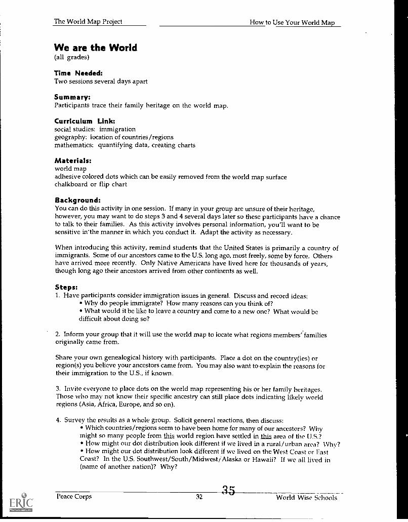
We are the World(all grades)
Time Needed:Two sessions several days apart
Summary:Participants trace their family heritage on the world map.
Currkulum Link:social studies: immigrationgeography: location of countries/regionsmathematics: quantifying data, creating charts
Materials:world mapadhesive colored dots which can be easily removed from the world map surfacechalkboard or flip chart
Background:You can do this activity in one session. If many in your group are unsure of their heritage,however, you may want to do steps 3 and 4 several days later so these participants have a chanceto talk to their families. As this activity involves personal information, you'll want to besensitive in'the manner in which you conduct it. Adapt the activity as necessary.
When introducing this activity, remind students that the United States is primarily a country ofimmigrants. Some of our ancestors came to the U.S. long ago, most freely, some by force. Othershave arrived more recently. Only Native Americans have lived here for thousands of years,though long ago their ancestors arrived from other continents as well.
Steps:1. Have participants consider immigration issues in general. Discuss and record ideas:
Why do people immigrate? How many reasons can you think of?What would it be like to leave a country and come to a new one? What would be
difficult about doing so?
2. Inform your group that it will use the world map to locate what regions members' familiesoriginally came from.
Share your own genealogical history with participants. Place a dot on the country(ies) orregion(s) you believe your ancestors came from. You may also want to explain the reasons fortheir immigration to the U.S., if known.
3. Invite everyone to place dots on the world map representing his or her family heritages.Those who may not know their specific ancestry can still place dots indicating likely worldregions (Asia, Africa, Europe, and so on).
4. Survey the results as a whole group. Solicit general reactions, then discuss:Which countries/regions seem to have been home for many of our ancestors? Why
might so many people from this world region have settled in this area of the U.S.?How might our dot distribution look different if we lived in a rural/urban area? Vhv?How might our dot distribution look different if we lived on the West Coast or East
Coast? In the U.S. Southwest/South/Midwest/Alaska or Hawaii? If we all lived in(name of another nation)? Why?
Peace Corps 32 World Wise Schools
The World Map Project Hew to Use Your World Map
How would our dot distribution have looked different 100 years ago? Why? Whatmight it look like 50 years in the future? Why?
Peace Corps Connection:Have your group ask the Volunteer about the cultural diversity in his or her host country:
Does the Volunteer's country have many people who trace their heritage to otherlands? Why or why not?
If people in the Volunteer's country trace their ancestry to other places, what placesare these? Why did people from these lands settle in the Volunteer's country? How didthey get there?
Variation:Gather recent U.S. Census information about your region from a -eublic library. Among otherthings, the Census breaks down information about your region's L'opulation by country of ethnicorigin. Convert this data to percentage and have your group post this distribution on the worldmap as in steps 3 and 4.
Peace Corps 33 World Wise Schools
The World Map Project How to Use Your World Map
Made In. . .(all grades)
Time Needed:One or two sessions
Summary:Participants locate countries on the world map that have manufactured common objects in theirdaily lives.
Curriculum Link:geography: location of countries/regions; natural resourcessocial studies: global economics; trade routes
Materials:world mapsmall squares of paper which can easily be affixed and removed from the world mapcellophane tape (if needed)pencils30-50 readily available objects from everyday life
The items must indicate their country of manufacture, e.g., "Made in China." You can collectthem before the activity or wait and have participants gather them from their immediatesurroundings. In a school setting, items could include any or all of the following:
classroom objects (globe, crayon box, ruler, and so on)contents of student backpacks or desks, voluntarily sharedlabeled apparel (shirts, shoes, jackets), voluntarily shared
Background:This activity introduces the concept of the interdependent global economy. Through just asampling of items, participants identify a few patterns in international trade. In many cases, thepatterns would have been far less complex one hundred years ago when a locality's economyexpanded little beyond its immediate region. Today, of course, is a different story. Because ofadvances in technology and infrastructure, natural resources move freely across the world andmanufacturing centers dot the globe.
Keep in mind that many countries exporting goods may not be represented in your map sample.First, your sample is very small. Big U.S. import items such as automobiles, electronics, andpetroleum products probably will not be represented in your sample at all. Second, not all nationstrade primarily with the United States; other markets exist for both geographic and politicalreasons.
Currently the United States im:orts more than it exports. A nation imports items for a variety ofreasons: it may lack the human or natural resources to manufacture the specific product; nationaldemand may outstrip the ability to provide the item; and/or it is more economical to import theitem than to manufacture it within country.
Steps:1. Inform your group it will be investigating where everyday objects have come from. Inanticipation of the lesson, have members "guess-timate" what percent of items they find will bemade in the U.S. compared to those made overseas.
2. Have participants work individually (or in pairs) to locate items in their immediateenvironment that state their country of manufacture. To avoid duplication of effort, you rimyneed to assign teams to specific search areas.
Peace Corps 34 World Wise Schools
The World Map Project How to Use Your World Map
3. Instruct searchers to draw a small sketch of each item on a paper square . Have them alsolabel the drawing with the name of the item and its country of origin.
4. When participants have identified and drawn at least 30 different items, have them go to themap and affix their squares by the relevant countries.
5. As a group, examine the product distribution on the world map. Solicit general reactions; thenanalyze the data by country, region, or continent. Look for patterns both in distribution and intypes of items exported from particular regions. Discuss:
a. What regions of the world seem to be the source of many of our imported items?Any pattern to the type(s) of items we import from this region?Why might this region export these particular things to the U.S.?How would items from this region reach the U.S.? What routes might the items take
to get here? How long might that take?
b. What regions of the world aren't as well represented in our sample? What might be some ofthe reasons for this?
c. How would our product distribution have looked different 50/100 years ago? Why?
d. What countries/regions of the world do you think import items from the U.S.? Why? Whatkind of items might these be? Why?
6. For advanced groups: Have members group research topics related to U.S. trade relations withother countries. Have researchers share their findings with the whole group, making use ofgraphs/charts and the world map as appropriate. Possible topics:
a. major U.S. import/export items
b. major U.S. trading partners
c. major trade routes to and from the U.S. (Trace them on an overlay; see p. 36-7)
d. trade imbalances and economic effects
e. major exports/imports of selected foreign nations
Variation:Have participants identify types and sources of all materials used to make one specific everydayproduct, such as a pencil, a chocolate bar, a running shoe. They'll need to write to themanufacturer for assistance. Share and post the information on the world map as it becomesavailable.
Peace Corps Connection:1. Have your group research the major imports and exports of the Volunteer's country.
Why might this country import the items it does?Why might this country export the items it does?With what nations does this country trade? Why?
2. Ask the Volunteer to list common manufactured items in his or her host country. Where werethese items made? Post this data on the map as in step 4. How are the patternssimilar/different from the U.S. import data? Why might this be?
Peace Corps 35 t World Wise Schools
The World Map Project How to Use Your World Map
World Watersheds (grades 6 and up)
Time Needed:Varies
Summary:Participants compare/contrast data drawn on an overlay across their world map
Curriculum Link:varies
Materials:world mapatlases that depict major rivers in each of the world's regionslarge sheets of acetate or other transparent plastic sheeting to cover the world mapstrong adhesive tapemarkers to use on the plastic overlay: permanent or washable--your choice, but test on the
overlay beforehandreference materials related to your specific topic
Steps:1. Secure a sheet (or sheets) of plastic across your world map.
2. Have participants use markers to trace the outline of the continents and large land masses ontothe plastic overlay.
3. Assign participants to specific regions on the map. Have them locate the major river systemsin that area.
4. When the watershed overlay is complete, have participants look for connections betweentheir data and the information on the world map beneath the overlay:
How frequently do rivers form natural boundaries between countries?How frequently are country capitals located on a river or near a body of water?
5. Extend the investigation by doing a second overlay directly on top of the first. Repeat steps 1and 2. This time have participants consult atlases to depict one of the following: mountainranges, location of major cities, regional population densities. Analyze the results:
What connections do participants see between any of these depictions and the locationof water systems?
What predictions could they make about specific countries on the world map basedupon these additional dimensions of information?
Variations:global patterns in vegetationglobal climate zonesglobal patterns in agricultureglobal patterns in populationdistribution of world's language groupsdistribution of world's major religionsformer areas of colonialismocean currentshistoric routes of explorers/navigators 3y
Peace Corps 36 World Wise Schools
The World Map Project How to Use Your World Map
current trade and travel routeshurricane trackingjet stream/prevailing wind patternsareas of acid rain falloutwildlife of the world (tape pictures of animals to country/regions of habitat: where is it possible
to predict the climate or terrain of that region based upon the type of wildlife living there?)bird/whale migration routesglobal reserves of oil and other natural resourcesearthquake/volcano zonesplate tectonicsdaily temperatures in select citieslocations of world-famous monuments/structurestime zones%vorld tourshot spots in the newscomparative data between nations: per capita GNP, coasumption rates, infant mortality rates,
water use, AIDS cases, population density, percent of persons under 15, military expenditure
4 0
Peace Corps 37 World Wise Schools
The World Map Project How to Use Your World Map
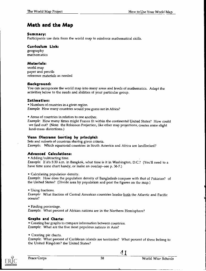
Math and the Map
Summary:Participants use data from the world map to reinforce mathematical skills.
Curriculum Link:geographymathematics
Materials:world mappaper and pencilsreference materials as needed
Background:You can incorporate the world map into many areas and levels of mathematics. Adapt theactivities below to the needs and abilities of your particular group.
Estimation:Numbers of countries in a given region.
Example: How many countries would you guess are in Africa?
Areas of countries in relation to one another.Example: How many times might France fit within the continental United States? How couldwe find out? (Note: the Robinson Projection, like other map projections, creates some slightland-mass distortions.)
Venn Diagrams (sorting by principle):Sets and subsets of countries sharing given criteria.Example: Which equatorial countries in South America and Africa are landlocked?
Advanced Calculations:Adding/subtracting time.
Example: If it's 5:30 a.m. in Bangkok, what time is it in Washington, D.C.? (You'll need to ahave time zone chart handy, or make an overlay--see p. 36-7.)
Calculating population density.Example: How does the population density of Bangladesh compare with that of Pakistan? ofthe United States? (Divide area by population and post the figures on the map.)
Using fractions.Example. What fraction of Central American countries border both the Atlantic and Pacificoceans?
Finding percentage.Example: What percent of African nations are in the Northern Hemisphere?
Graphs and Charts:Creating bar graphs to compare information between countries.
Example: What are the five most populous nations in Asia?
Creating pie charts.Example: What percent of Caribbean islands are territories? What percent of these belong tothe United Kingdom? the United States?
41Peace Corps 38 World Wise Schools
The World Map Project How to Use Your World Map
Interpreting Statistics:Comparing similar data among different countries, representing information in a visual, non-graph way.
Example #7. Using a resource like a world almanac, find the per capita GNP for various nations.Represent this information on your map, using adhesive (but removable) sticker dots, where onedot = x number of dollars. Remember to create a key to accompany your dot display.
Exam& #2: Collect daily temperature readings from cities around the globe (check dailypaper). Post the data on the world map:
track temperature patterns for one or more dayscalculate average daily highs/lows, or rangesearch for patterns in global temperature distribution: What's the effect of longitude?
latitude? being near bodies of water? elevation?
2Peace Corps 39 World Wise Schools

Part III: Resources For MakingYour World Map

The
Wor
ld M
ap
0C
,04
,40
/. *''',
1,_,
1110
tti
'II
INtg
:
4-
de o
w,,,
diiii
irIt
issv
iAie
PA
rik.
got
.
,V
I. .L
---.
.
1
L A
G
oec.
--
.
..."
4 . O
-; s
r4
- -
-
.
-
1 iiris %
mill
i..
:::;!
,..t.:
.,::.
;:..
.::*
N
40..i
r..
*4(4
.
,.
..i) 1 1.
. .
fh
14.4
1A
llir
.. ...
:
/JO Iv
kit
.
.:,:
.
*-:.:
-..,:
:....
::....
...::.
-.
..
.:.
'-
l"W
4
Ca,
_:,
*0
. ,-.
..101
1111
1
,7,_
_V+
41.1
,---
..,
4 5
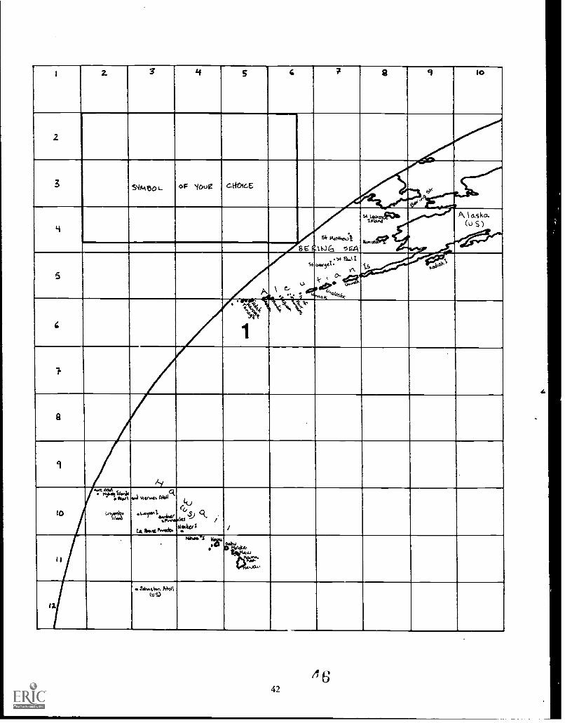
I 2. S 4 5 4 7 2 9 lo
2
-
3S404to L. 0 F NiOue cHoice
...
4s"'414.-4
tWG '5 giA
54ifts1"4
14,4*
A I asko.(u S )
5
A
r 5+ 11.11Oftr5el.
.n
a it '4'44
tSii:Pdru_
,0,0?0,.
4
. 41,"q15, t
1
7.
8
9
lls.ls. Nogg
.a._,6_
- /liakel 1 I
I
141miel irs,o,
. m.w
12.
(oS)
4 642
i S 16 1 7. l'f11 12A R C. -7 ft._
4. 1/AI.......t 0
NoR ai IX.'?: :11411r' -4r7154:1
....au , 410 -10
1:11. iv5SAuF," Sep' 41_01.,-4-ofitia
(i, 5) "API seco.k 3earLoJLe 2' co ar
1111
,.....141.1oSon;
E.Av41 ,.,....,,ar-i .1% 1
%JeanC r 4chottoft ,...i. CANADAr
izgoilik 41
0
aim.At 1111111111111
,.......9.,3 C:20- oc *11 7.9x
CI 'WI , cc ,,. ,M cc)eg I
--. .,t1r.rv-,...1(.):Las ., 4:)0 .st' ck .
(,).) , "11,61.4 al'e ') .'14 4 ' ) I 1 : 51,' a5Revtha . , ed.
L es ..j. .vr.r.ow. II,4"-- .-\.? obon.,1,,,),6: MokiDuRAS
/' ' ° 7* 3., 0 Ma, ..,*
etil;Ili 441' ctv
tit.'. . 1 06R.Efoun'c%,
43
t'.AZb,,A4
Ftd.m DOS
.14.03AZ 1r
44
CRKL g COM
45
DilbouT somim.% A
BEST COPY AVAILABLE
3 a-
39 £40
TIC-4i
OC..EAM.
42 43 44.5 44
I
es*
%ASIA4
1
i
MOROI-AN
SA kik,
MON 6 0 LI A
I. 3'Nft\*.orIN 1
ussar..s,
*s
14MATIATAN
Softrti
I 77141 t
V
I* 4111111PAL
1
MI.St STAN'.
CHINk
* Koftil
`I L L.&
Sf.A 1b
,
WAR Nis Tp 0
14116q0111..;,..cl...
Ilit,
. .
1 6:40.z.,,A,
i %
f3A4. I
.11,...AR VIETW At.,i*
l. AOS
Ni
"Vez.:t)
ki.,
(..4! a.,-,60.,... Ce rIt-HA
BCN,;,AL
Anelament5iand:
CtivDIA)1
.
1
'
TRAILA ND
PAmPUCIlte, #A nr.
'4.
.5'..0cn
k.;
r 0046
NORTH PACIF IC OCEAN
BEST COPY AVAILABLEr
47
.G.1.4.,... Mat Cc S,
ki
$....r
Tc...,...,..1.1....aerM
is4 .... OF,
("\ri.,
L-EOUCCIOR\ QUATOR
15
EQOPNOR
. ..r -ocAn. Ls
R \EIP\I- i
'faros L
Ncjent.
54n,bucif. .
,c'
1 7
1(3 lokelaL,go,...., !, 41/-,r
i'' '00
rwir.in. 4101. kkemer4... kiG
,
.C.OrOitilesJovok.4^t .,.....
V:44 OCL Ow'14.6..a...? Fa,Marvesos
thve.
14es
.41.n.1
,,asso.,....5ESTERA.1
r SAK.2A a
tA ,,... . (V.S)TA., !.-. f. S.i.... 41.1.:21..fubik,
1-
5.00tre,..,1 <I,ioA Ir
<
i
Fi,+ I.
49; '41^14,r °°P'");;;,.Mek, 0,* _or "m.o. . -=,..._..
l B Fere. .. .te--/44.....e...4 ..-rower, 4.:.:
Wands (FR)
jtkki.-- .4,
s :R44,4 C11441To
6,
...L.,.../tFOC .4"%
Okk-Gar
-..r ..v.yeo__ c' 6,..r
22,.. '::4*:sta km,.,..
i foNEIAd $4,..kwaxia
,,,,,,,,, 6.fL.? AD.
,,d2g,P,..,,......... otsA4Il r V
-, :.'''.1Ark,airv.)
RafeAper.
e 1', ; °T*Itekek.%,0-4,'"" S .e're L..c.." Po
4*.l.b.a.ce' i.to
Hakiko. k....oklf. fluNG,..
ak Ar.:*,i,c).2.
',Ines ia..Aereitava..
...aks ',4c aasuctsfer .\..
""ezL.. ,.9 0
... .0'1/44
(.l.ti.1-ID 141)46)onA)
19
Kermadec, s (N.z.)
.s./
I
..1"4'-A
ci$ ."44'
,1,. 6,........
ke..<4ers.,P,Gccae '..
1
2.0
Racul 1
PkactlayC....0,s1.LE,srtrtf,Ct
I .
Rtek
SCUT A P c... I C OCE N1\1
2.2
o... 1.)
2.3
24
I 2 '3 9 5 T. 8 1 to
BEST COPY AVAILABLE
48 5 2

VEKI E Z.OE1A
EQUKTOR
60.1a p.54'5 IS 43'65aCvADOR
BRAZ. fl
Eas ler;(olo.e)
SOOT I-1 PACIF OCEANAREIEw INA
49
60.1JEAB6SAU Rikoop, T ASO
.
60NEA
0°04N.I. an-E.
4,4 D'INfoIRE
1
-
(01ANA -
... I
(et cr
.9.
UkTOR
s kge, t 5410 441. (BAR..IL)
r' .......
I
EQ
114(A; .01Fry:,.e.tm
No.-44V. (BRAVO
EQuA10 R-
fyrOVZAL
ASc err,on(uk.)
*s+. 1..t.e.e,i..cl K )i 171.ZIL Zt;tigi'l
Of4A7-1 0I
o.5,.)..
v Go k(
b 0 uT -i ATLAsmc. OC.P.C1\1
9..r... ,..- 4. C-....,...1'Nal C.CS'Sslolt I
.,.,,...e.,,,... i,r..,.. r...,
,-.........;
> r. t-,.It ".-
116.--
2.0 2J z a.
r.,a: ,tak- ,- 46.,"
2.
sz ..t f.--......r.,
2.4
!.v....r.,..!
25 ''%' '''al 26 27. 18
50
'":5".1-
54
BEST COPY AVAILABLE
111'141)1"R KAMVlEtM
l-4.6...44..etp.Cmo ict)
. .ftmt.01
1.
r1...a, .<in .:::.
,n )...,,,,4.a.
i NOIR
tha.nuch441., iv
.
iv. ma le 414:
:
ki-otiAm. mv,s
Arttoma..All 1...le(t NDIA)
Carikl.c.obar
itiandS0.4DtA
erdsman t..
Ncobar:
.0(2.e-th 14.'46°' hi:
5ul.e44
Nis
5, ker ui- 1Kep...lawat
MenittwIll%
111
. .,
(tc''
.. SCi
4. ct-A. ki..., v)
C.?P
. t
EQUATOR
-titi: .14
%WPM.
KaP
3/4,,
ENikne
4.
eneo
?erasso,-.6-47*. cKups
EQUAMR^99°-
..
i NDna t:.Dtor bag**
1:1ecln I pelo9 o/EIR,T ,wo,A.s\k,orsAmittermo,1 /
c.hrkkmact.Cavs-txnuA)
C:63 ats.... 1
Coc.os IsIands(iNuS<R4t_%A)
i
Rodr;3049CsAuflo- I 5)
INDIAN OCEAN
k.',STRR LI a
Ite NP,sierd.w., .?tot P...i
(FRmcS) 1 1
kar3uE len IsV' R)
_.
..V41 5L41
skalax.
ers!C:.4)".a. A L.
0kusiaRt_40
38 31 40 4 1 41 43 4 4 45 4
5652
73
5
a
le
23
pioLLIPPikEs ti\ cro
144./111
<-4- 49',, .4,.....,6:..Y ..
,..,-
4'47
.; cr
,,,,k,i,;L.,.., kioll , .f,,,,,p1. Mon,.
,6`,.. `r ZI.,............,. !C.'s.- (,Le z ,,,.. . ....i.,t
RAVSJK
',...° ., *S" °le'''Y ,t ..,"$ . c'".. 0,4.i._
. e..` '.
MPH I Is..)."0`.7.11tljoe Atoll
1/ It0mvkvit's-f°CP.
. cc ..,.
c,,,' .0...m.jeli4.11. . :, ,... .
4611 '9/(1,
..r,.,34...t Awl .4.15_
Z647,, 44". ::Aren 14.4l
M.I./if o:, tk
crr
\3
9 pso T/avo 3
nnfol.a. 0
kw11.4,..r.radii.° hThd'A'W" \ _..... S.0
r-SoncoroiI.fie, ...
61 teniKee
ec
cA_ rM
s4.,..k f-,0 1
I....
,,,, Won
c 4:n e
w.44-1"'"'NaV
Kesake
tAcecnesta.1.c,
E kw-, PrhAt .
1/4s%
`Z
f.suketAare.
irr ......40(0/04, 1
.... Mt1.0.0 I
- ,..A60..0.0.
-AesCP......
3,
114
T. '-' c...
fi N
P'\ 4:4Qr
E. 5
%Sok EOUKTOR
A PAPLY;
HartoyerN WO
.9
Iltit
E Q UASOil
6,,,
Nati 11.0.6,-
A/w....4.,..43
''/ Rrolt
e.., .,-..,.......,1
.... :. .......,
cs- --g---
1
.0010"0..
;A...AA--
15
,..5M719.11i4VVNASt. 0^04. 0 4 Mel., ke I
.0 Zs,....
u ,JI0
NEVJ OUINEA
6.4Ref"'
OL c5kl''
400.0> tD1(19- SCO4'
' Stestr!Is 61\50i, . await.&man, .1). it
Al tk",br/9,,44., tevell4;v rS LA ND S WidAidel Pn.,..,.t.
,.-1- 1 4.414vP°.7w/feu.,
. glitlaticeC' 'y
0 .C
'9. <1 Coma seo-:. t,
iur...vo- ry; Terre) 4-5r%
G i r411vS,1,, I'11,10...,z 0 &DV,- . 4.1......._c_
ri.., 7"
P IT Irt
Tern-A-or q(AvST "IA ileis
c<'' -2
ci,esivielo;O.kle., \ 10,"// 061;11V
CaletSelni ../
CP g.)lit des F'
..+,
fitino-11111.14
.".4MsfitIll.:..1...lelptie"."'''
KatlaAr
tes
AUSTRALIk
.
Pr`SOuTH PP\c.,Fic
iOGEAN lq
'lit...>er
Baits Prz.,-ci(Au 'MAL( A)
0:juS1-12All A)
1,4,0-15 li
2i)
ic1" T A Boss-4, sfiv....1- :F,,,...tau. (.',P
S.)
`<...C'-)WifI.
Ark 13.1.-..erl.
I
2.1
PIP'1 2
, ,14
411111
r"Pr
2.2
.
kl...aPC 15 p
ll..rnell 1 ,
e.TI.w. ',vac'.
lYI , .7)
I
.. ';' ',r, AP" .1:.
t. 7 23
/KV tr.rly IC 7,-
. '.'.0...,co
1.4 q so 51 52 53 5 4 55
14
66
53
25
I/
ZS
,
1 6
. .
kr...A
.,
29 3 0 11 32 13 34 SS 34 3*
1 7
ft,ipw
616
ilpir11 43 II 4
or3 1 31 40 40 sir
25
24
_
1 8ZS
26
2*
441. 18 411 So SI 52. 53 S4 55
28
Si
355
The World Map Project Resources for Making Your World Map
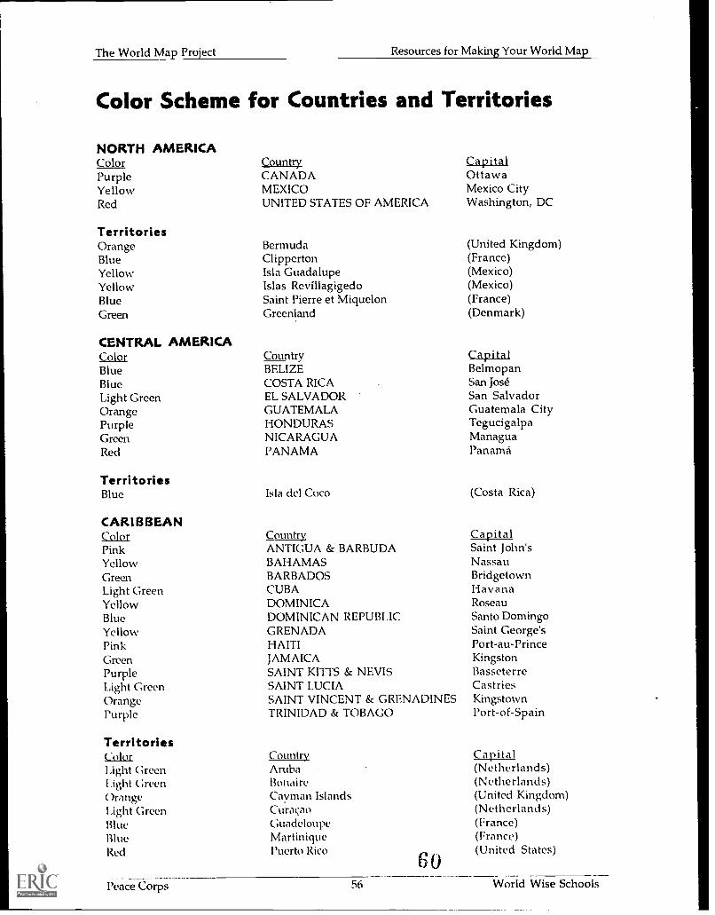
Color Scheme for Countries and Territories
NORTH AMERICAColorPurpleYellowRed
TerritoriesOrangeBlueYellowYellowBlueGreen
CENTRAL AMERICAColorBlueBlueLight GreenOrangePurpleGreenRed
TerritoriesBlue
CARIBBEANColorPinkYellowGreenLight GreenYellowBlueYellowPinkGreenPurpleLight GreenOrangePurple
TerritoriesColorLight GreenI .ight GreenOrangeLight GreenBlueBlueRed
CountryCANADAMEXICOUNITED STATES OF AMERICA
BermudaClippertonIsla GuadalupeIslas RevillagigedoSaint Pierre et MiquelonGreenland
CountryBELIZECOSTA RICAEL SALVADORGUATEMALAHONDURASNICARAGUAPANAMA
Isla del Coco
CountryANTIGUA & BARBUDABAHAMASBARBADOSCUBADOMINICADOMINICAN REPUBLICGRENADAHAITIJAMAICASAINT KITTS & NEVISSAINT LUCIASAINT VINCENT & GRENADINESTRINIDAD & TOBAGO
CountryArubaBonaireCayman IslandsCuracaoGuadeloupeMartiniquePuerto Rico
60
CapitalOttawaMexico CityWashington, DC
(United Kingdom)(France)(Mexico)(Mexico)(France)(Denmark)
CapitalBelmopanSan JoséSan SalvadorGuatemala CityTegucigalpaManaguaPanama
(Costa Rica)
CapitalSaint John'sNassauBridgetownHavanaRoseauSanto DomingoSaint George'sPort-au-PrinceKingstonBasseterreCastriesKingstownPort-of-Spain
Capital(Netherlands)(Netherlands)(United Kingdom)(Netherlands)(France)(France)(United States)
Peace Corps 56 World Wise Schools
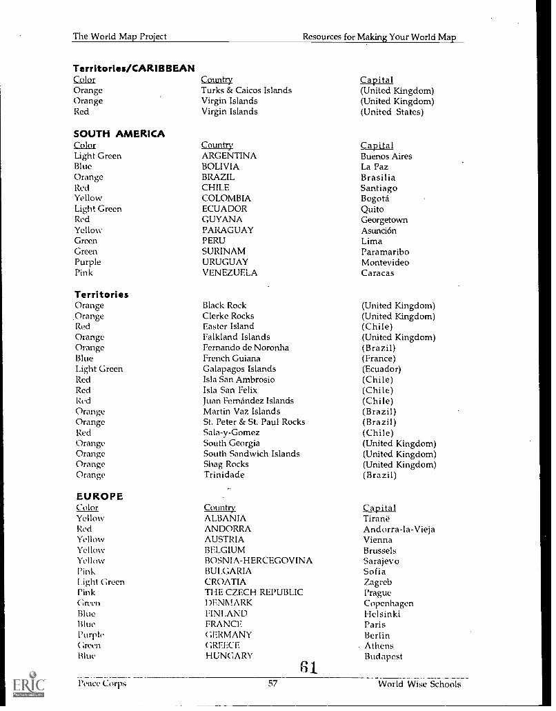
The World Map Project Resources for Making Your World Map
Territories/CARIBBEANColor Country CapitalOrange Turks & Caicos Islands (United Kingdom)Orange Virgin Islands (United Kingdom)Red Virgin Islands (United States)
SOUTH AMERICAColor Country CapitalLight Green ARGENTINA Buenos AiresBlue BOLIVIA La PazOrange BRAZIL BrasiliaRed CHILE SantiagoYellow COLOMBIA BogotaLight Green ECUADOR QuitoRed GUYANA GeorgetownYellow PARAGUAY AsunciónGreen PERU LimaGreen SURINAM ParamariboPurple URUGUAY MontevideoPink VENEZUELA Caracas
TerritoriesOrange Black Rock (United Kingdom)
.Orange Clerke Rocks (United Kingdom)Red Easter Island (Chile)Orange Falkland Islands (United Kingdom)Orange Fernando de Noronha (Brazil)Blue French Guiana (France)Light Green Galapagos Islands (Ecuador)Red Isla San Ambrosio (Chile)Red Isla San Felix (Chile)Red Juan Fernandez Islands (Chile)Orange Martin Vaz Islands (Brazil)Orange St. Peter & St. Paul Rocks (Brazil)Red Sala-y-Gomez (Chile)Orange South Georgia (United Kingdom)Orange South Sandwich Islands (United Kingdom)Orange Shag Rocks (United Kingdom)Orange Trinidade (Brazil)
EUROPEColor Country CapitalYellow ALBANIA TiraneRed ANDORRA Andorra-la-ViejaYellow AUSTRIA ViennaYellow BELGIUM BrusselsYellow BOSNIA-HERCEGOVINA SarajevoPink BULGARIA Sofia1 .ight Green CROATIA ZagrebPink THE CZECH REPUBLIC PragueGreen DENMARK CopenhagenBlue FINLAND HelsinkiBlue FRANCE ParisPurple GERMANY Berlin( lreen GREECE AthensBlue HUNGARY Budapest
61.Peace Corps 57 World Wise Schools
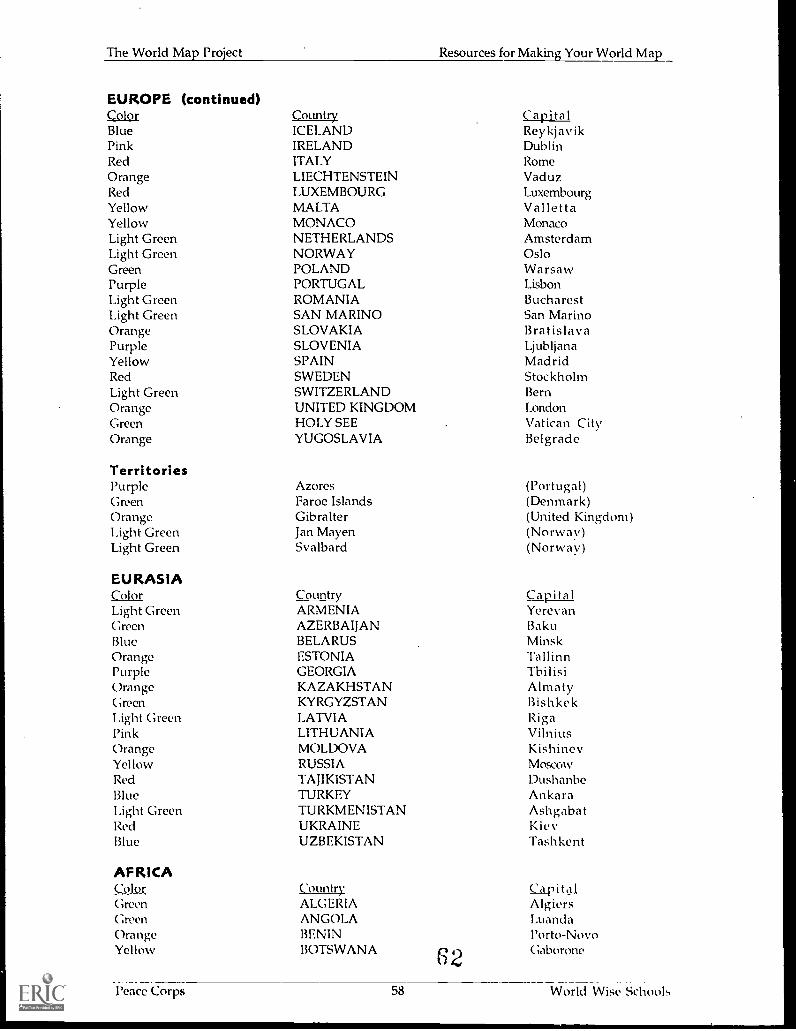
The World Map Project Resources for Making Your World Map
EUROPE (continued)Color Country CapitalBlue ICELAND ReykjavikPink IRELAND DublinRed ITALY RomeOrange LIECHTENSTEIN VaduzRed LUXEMBOURG LuxembourgYellow MALTA VallettaYellow MONACO MonacoLight Green NETHERLANDS AmsterdamLight Green NORWAY OsloGreen POLAND WarsawPurple PORTUGAL LisbonLight Green ROMANIA BucharestLight Green SAN MARINO San MarinoOrange SLOVAKIA BratislavaPurple SLOVENIA LjubljanaYellow SPAIN MadridRed SWEDEN StockholmLight Green SWITZERLAND BernOrange UNITED KINGDOM LondonGreen HOLY SEE Vatican CityOrange YUGOSLAVIA Belgrade
TerritoriesPurple Azores (Portugal)Green Faroe Islands (Denmark)Orange Gibralter (United Kingdom)Light Green Jan Mayen (Norway)Light Green Svalbard (Norway)
EURASIAColor Country CapitalLight Green ARMENIA YerevanGreen AZERBAIJAN BakuBlue BELARUS MinskOrange ESTONIA TallinnPurple GEORGIA TbilisiOrange KAZAKHSTAN AlmatyGreen KYRGYZSTAN BishkekLight Green LATVIA RigaPink LITHUANIA VilniusOrange MOLDOVA KishinevYellow RUSSIA MoscowRed TAJIKISTAN DushanbeBlue TURKEY AnkaraLight Green TURKMENISTAN AshgabatRed UKRAINE KievBlue UZBEKISTAN Tashkent
AFRICAColor CountryGreen ALGERIAGreen ANGOLAOrange BENINYellow BOTSWANA 62
CapitalAlgiersLuandaPorto-NovoGaborone
l'eace Corps 58 World Wise Schools
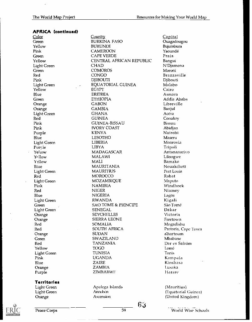
The World Map Project Resources for Making Your World Map
AFRICA (continued)ColorGreenYellowPinkGreenYellowLight GreenGreenRedPinkLight GreenYellowBlueGreenOrangeOrangeLight GreenRedPinkPinkPurpleBlueLight GreenPurnleYeliowYr.11owYellowBlueLight GreenRedLight GreenPinkRedBlueLight GreenGreenLight GreenOrangeOrangeRedRedOrangeGreenRedYellowLight GreenPinkBlueOrangePurple
TerritoriesLight GreenLight GreenOrange
CountryBURKINA FASOBURUNDICAMEROONCAPE VERDECENTRAL AFRICAN REPUBLICCHADCOMOROSCONGODJIBOUTIEQUATORIAL GUINEAEGYPTERITREAETHIOPIAGABONGAMBIAGHANAGUINEAGUINEA-BISSAUIVORY COASTKENYALESOTHOLIBERIALIBYAMADAGASCARMALAWIMALIMAURITANIAMAURITIUSMOROCCOMOZAMBIQUENAMIBIANIGERNIGERIARWANDASAO TOME & PRINCIPESENEGALSEYCHELLESSIERRA LEONESOMALIASOUTH AFRICASUDANSWAZILANDTANZANIATOGOTUNISIAUGANDAZAIREZAMBIAZIMBABVVE
Apalega IslandsAnnobónAscension
63
CapitalOuagadougouBujumburaYaoundéPraiaBanguiN'DjamenaMoroniBrazzavilleDjiboutiMalaboCairoAsmaraAddis AbabaLibrevilleBanjulAccraConakryBissauAbidjanNairobiMaseruMonroviaTripoliAntananarivoLilongweBamakoNouakchottPort LouisRabatMaputoWindhoekNiameyLagosKigaliSAo TomeDakarVictoriaFreetownMogadishuPretoria, Cape TownKhartoumMbabaneDar es SalaiimLomeTunisKampalaKinshasa,usa ka
Harare
(Mauritius)(Equatorial Guinea)(United Kingdom)
Peace Corps 59 World Wise Schools

The World Map Project Resources for Making Your World Map
Territories/AFRICAColorLight GreenGreenYellowLight GreenYellowBluePurpleBlueBlueBluePurpleBluePurpleYellowRedLight GreenOrangeOrangeBluePink
MIDDLE EASTColorPurpleLight GreenPinkRedPinkRedGwenYellowLight GreenPurpleOrangePurpleOrangeBlueOrange
; wenYellow
TerritorieslkirpleYellow
ASIAColor
lkirplc;reen
YellowYellowPink
ight GreenOrange
(continued)CountryBouvetCabindaCanary IslandsCargados Carajos ShoalsCeutaCrozet IslandsHeard IslandsIle AmsterdamIle St. PaulKerguelen IslandsMadeiraMayotteMcDonald IslandMelillaPrince Edward IslandsRodriguesSt. HelenaTristan Da Cunha GroupTromelinWestern Sahara
CountyAFGHANISTANBAHRAINCYPRUSIRANIRAQISRAELJORDANKUWAITLEBANONOMANPAKISTANTERRITORY UNDER PARTIALOATARSAUDI ARABIASYRIAUNITED ARAB EMIRATESYEMEN
Al KhasabSocotra
CountryBANGI.ADESHBHUTANBRUNEIMYANM ARCHINAINDIAINDONESIA
64
Capital(Norway)(Angola)(Spain)(Mauritius)(Spain)(France)(Australia)(France)(France)(France)(Portugal)(France)(Australia)(Spain)(South Africa)(Mauritius)(United Kingdom)(United Kingdom)(France)(Morocco)
Ca p it alKabulManamaNicosiaTehranBaghdadJerusalemAmmanKuwaitBeirutMuscatIslamabad
PALESTINIAN CONTROLDohaRiyadhDamascusAbu DhabiSanaa
(Oman)(Yemen)
CapitalDhakaThimphuBandar Seri BegawanYangonBeijingNew DelhiJakarta
l'eace Corps 60 World Wise Schools
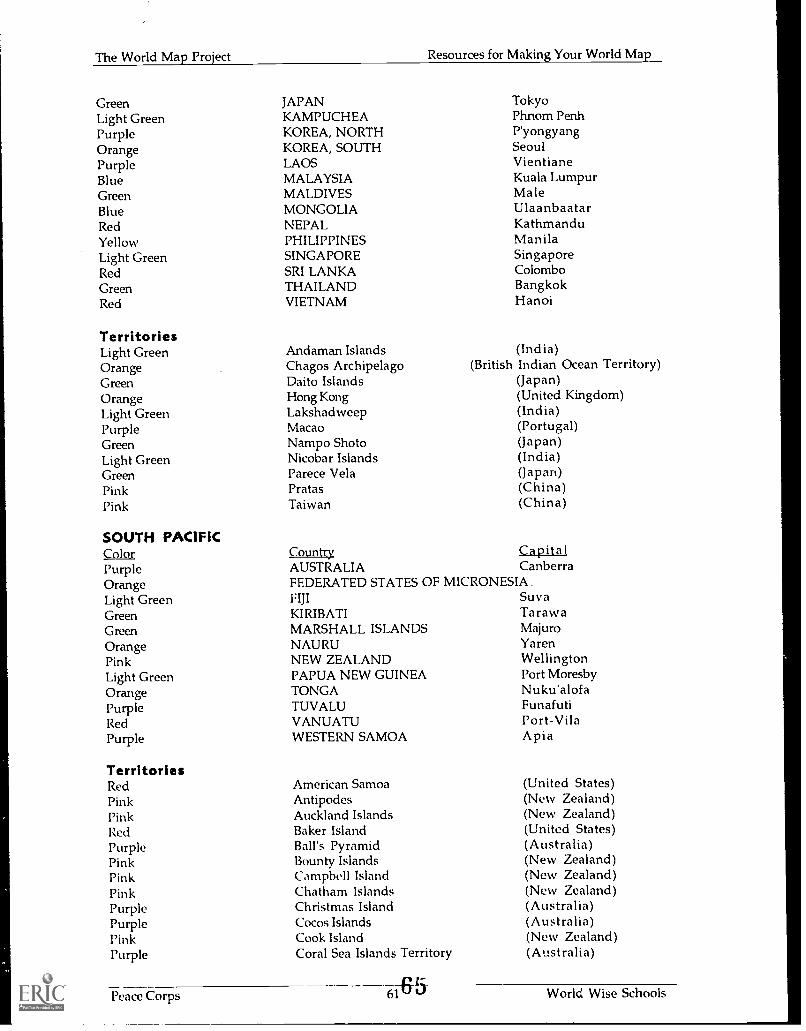
The World Map Project Resources for Making Your World Map
Green JAPAN TokyoLight Green KAMPUCHEA Phnom PenhPurple KOREA, NORTH P'yongyangOrange KOREA, SOUTH SeoulPurple LAOS VientianeBlue MALAYSIA Kuala LumpurGreen MALDIVES MaleBlue MONGOLIA UlaanbaatarRed NEPAL KathmanduYellow PHILIPPINES ManilaLight Green SINGAPORE SingaporeRed SRI LANKA ColomboGreen THAILAND BangkokRed VIETNAM Hanoi
TerritoriesLight Green Andaman Islands (India)Orange Chagos Archipelago (British Indian Ocean Territory)Green Daito Islands (Japan)Orange Hong Kong (United Kingdom)Light Green Lakshadweep (India)Purple Macao (Portugal)Green Nampo Shoto (Japan)Light Green Nicobar Islands (India)Green Parece Vela (Japan)Pink Pratas (China)Pink Taiwan (China)
SOUTH PACIFICColor Country CapitalPurple AUSTRALIA CanberraOrange FEDERATED STATES OF MICRONESIALight Green FIJI SuvaGreen KIRIBATI TarawaGreen MARSHALL ISLANDS MajuroOrange NAURU YarenPink NEW ZEALAND WellingtonLight Green PAPUA NEW GUINEA Port MoresbyOrange TONGA Nuku'alofaPurple TUVALU FunafutiRed VANUATU Port-VilaPurple WESTERN SAMOA Apia
TerritoriesRed American Samoa (United States)Pink Antipodes (New Zealand)Pink Auckland Islands (New Zealand)Red Baker Island (United States)Purple Ball's Pyramid (Australia)Pink Bounty Islands (New Zealand)Pink Campbell Island (New Zealand)Pink Chatham Islands (New Zealand)Purple Christmas Island (Australia)Purple Cocos Islands (Australia)Pink Cook Island (New Zealand)Purple Coral Sea Islands Territory (Australia)
Peace Corps 61-6-zd World Wise Schools
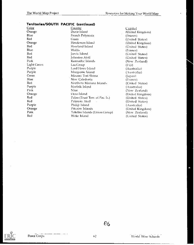
The World Map Project Resources for Making Your World Map
Territories/SOUTH PACIFIC (continued)Color Country Ciw i ta IOrange Dude Island (United Kingdom)Blue French Polynesia (France)Red Guam (United States)Orange Henderson Island (United Kingdom)Red Howland Island (United States)Blue Wallis (France)Red Jarvis Island (United States)Red Johnston Atoll (United States)Pink Kermadec Islands (New Zealand)Light Green I .au Group (Fiii)Purple I.ord Howe Island (Australia)Purple Macquarie Island (Australia)Green Minami Tori Shima (Japan)Blue New Caledonia (France)Red Northern Mariana Islands (United States)Purple Norfolk Island (Austraha)Pink Niue (New Zealand)Orange Oeno Island (United Kingdom)Red l'alau (Trust Terr. of Pac. Is.) (United States)Red Palmyra Atoll . (United States)Purple Philip Island (Australia)Orange Pitcairn Islands (United Kingdom)Pink Tokelau Islands (Union Group) (New Zealand)Red Wake Island (United States)
616
_
Peace Corps (12 11orld Wise Schools
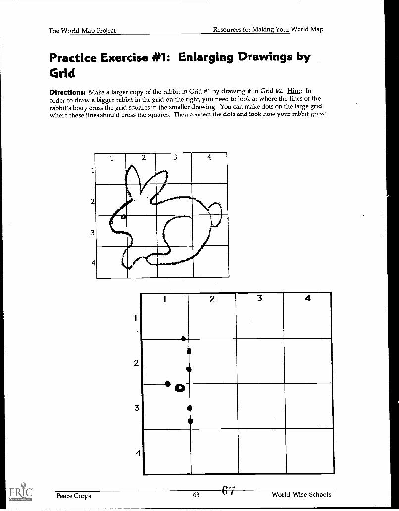
The World Map Project Resources for Making Your World Map
Practice Exercise #1: Enlarging Drawings byGridDirections: Make a larger copy of the rabbit in Grid #1 by drawing it in Grid #2. Hint: Inorder to draw a bigger rabbit in the grid on the right, you need to look at where the lines of therabbit's boa)/ cross the grid squares in the smaller drawing. You can make dots on the large gridwhere these lines should cross the squares. Then connect the dots and look how your rabbit grew!
1
2
3
4
1 4
1
2
3
4
1
e
2 3 4
0
r
Peace Corps 63 World Wise Schools
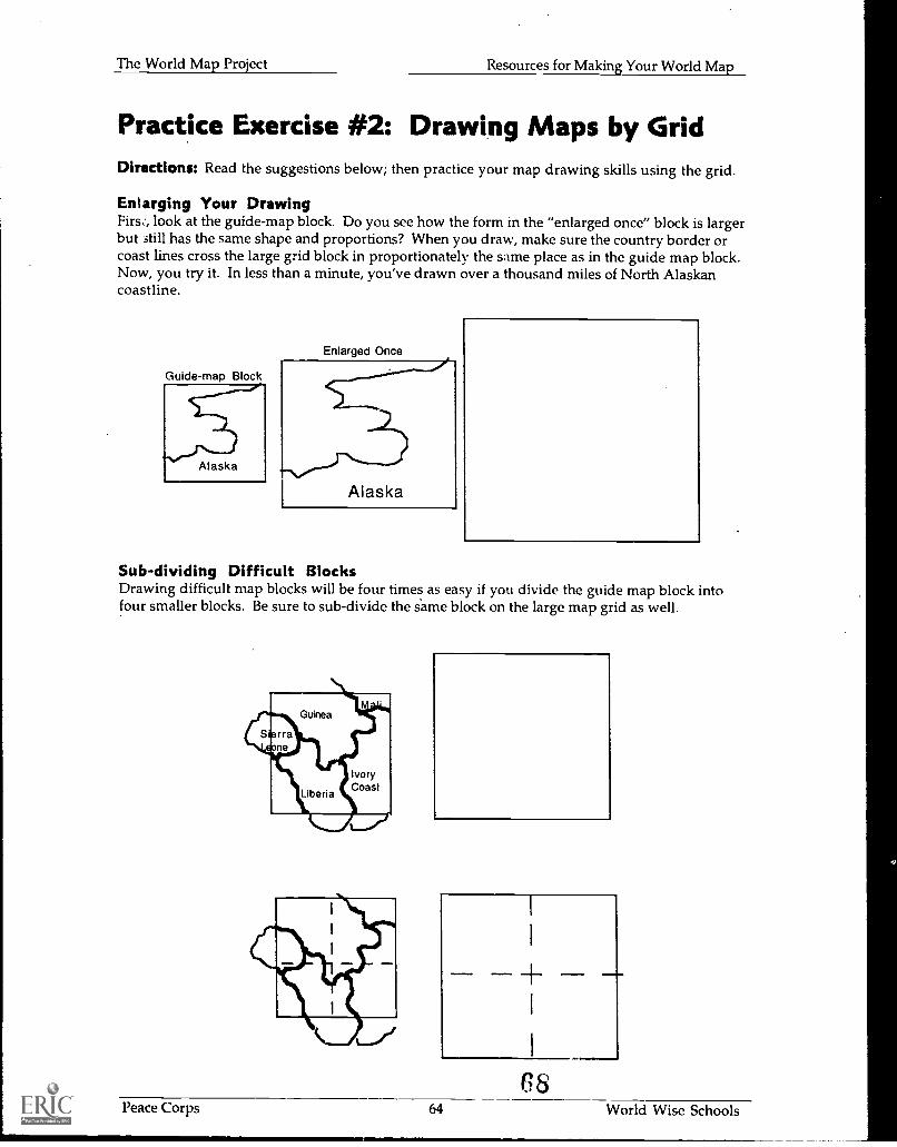
The World Map Project Resources for Making Your World Map
Practice Exercise #2: Drawing Maps by GridDirections: Read the suggestions below; then practice your map drawing skills using the grid.
Enlarging Your DrawingFirs:, look at the guide-map block. Do you see how the form in the "enlarged once" block is largerbut 3till has the same shape and proportions? When you draw, make sure the country border orcoast lines cross the large grid block in proportionately the same place as in the guide map block.Now, you try it. In less than a minute, you've drawn over a thousand miles of North Alaskancoastline.
Guide-map Block
Alaska
Enlarged Once
Alaska
Sub-dividing Difficult BlocksDrawing difficult map blocks will be four times as easy if you divide the guide map block intofour smaller blocks. Be sure to sub-divide the s'ame block on the large map grid as well.
G8Peace Corps 64 World Wise Schools
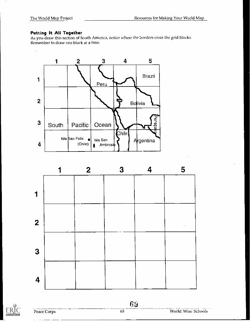
The World Map Project Resources for Making Your World Map
Putting It All TogetherAs you draw this section of South America, notice where the borders cross the grid blocks.Remember to draw one block at a time.
1
2
3
4
1 2 3 4 5
Peru
Brazil
.....Bolivia
South Pacific Ocean
-0co-,.,
Isla San Felix
(Chile)Isla Sani Ambrosio
hile
t
Argentina
Peace Corps
6965
_
World Wise Schools
Appendix
7u
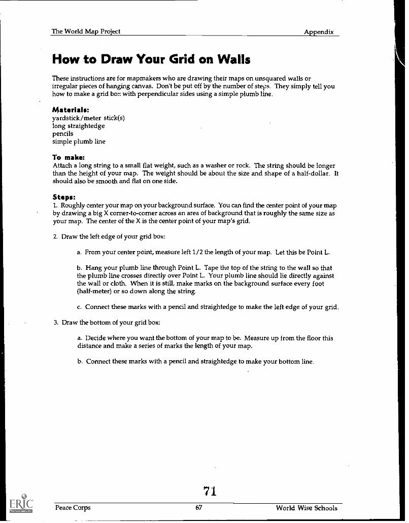
The World Map Project Appendix
How to Draw Your Grid on WallsThese instructions are for mapmakers who are drawing their maps on unsquared walls orirregular pieces of hanging canvas. Don't be put off by the number of steps. They simply tell youhow to make a grid bo:-: with perpendicular sides using a simple plumb line.
Materials:yardstick/meter stick(s)long straightedgepencilssimple plumb line
To make:Attach a long string to a small flat weight, such as a washer or rock. The string should be longerthan the height of your map. The weight should be about the size and shape of a half-dollar. Itshould also be smooth and flat on one side.
Steps:1. Roughly center your map on your background surface. You can find the center point of your mapby drawing a big X corner-to-corner across an area of background that is roughly the same size asyour map. The center of the X is the center point of your map's grid.
2. Draw the left edge of your grid box:
a. From your center point, measure left 1/ 2 the length of your map. Let this be Point L.
b. Hang your plumb line through Point L. Tape the top of the string to the wall so thatthe plumb line crosses directly over Point L. Your plumb line should lie directly againstthe wall or cloth. When it is still, make marks on the background surface every foot(half-meter) or so down along the string.
c. Connect these marks with a pencil and straightedge to make the left edge of your grid.
3. Draw the bottom of your grid box:
a. Decide where you want the bottom of your map to be. Measure up from the floor thisdistance and make a series of marks the length of your map.
b. Connect these marks with a pencil and straightedge to make your bottom line.
71Peace Corps 67 World Wise Schools
1
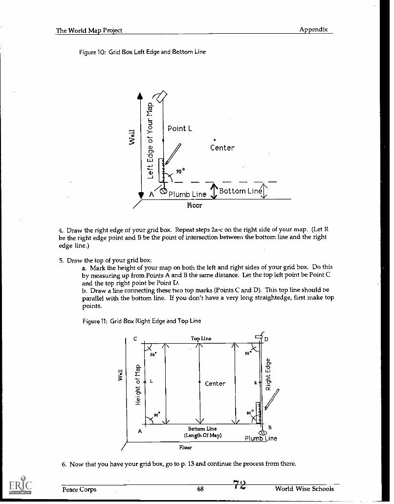
The World Map Project Appendix
Figure 10: Grid Box Left Edge and Bottom Line
Point L
90°
Center
Plumb Line Bottom Llne
Floor
4. Draw the right edge of your grid box. Repeat steps 2a-c on the right side of your map. (Let Rbe the right edge point and B be the point of intersection between the bottom line and the rightedge line.)
5. Draw the top of your grid box:a. Mark the height of your map on both the left and right sides of your grid box. Do thisby measuring up from Points A and B the same distance. Let the top left point be Point Cand the top right point be Point D.b. Draw a line connecting these two top marks (Points C and D). This top line should beparallel with the bottom line. If you don't have a very long straightedge, first make toppoints.
Figure 11: Grid Box Right Edge and Top Line
0_
45
qi7)
A
Top Liner 1190 90"
Center
90*900
Bottom Line(Length Of Map)
Floor
6. Now that you have your grid box, go to p. 13 and continue the process from there.
Peace Corps 68 World Wise Schools
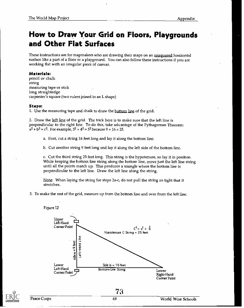
The World Map Project Appendix
How to Draw Your Grid on Floors, Playgroundsand Other Flat SurfacesThese instructions are for mapmakers who are drawing their maps on an unsquared horizontalsurface like a part of a floor or a playground. You can also follow these instructions if you areworking flat with an irregular piece of canvas.
Materials:pencil or chalkstringmeasuring tape or sticklong straightedgecarpenter's square (two rulers joined in an L shape)
Steps:1. Use the measuring tape and chalk to draw the bottom line of the grid.
2. Draw the left line of the grid. The trick here is to make sure that the left line is'perpendicular to the right line. To do this, take advantage of the Pythagorean Theorem:a2 + b2 = c2. For example, 32 + 42 = 52 because 9 + 16 = 25.
a. First, cut a string 16 feet long and lay it along the bottom line.
b. Cut another string 9 feet long and lay it along the left side of the bottom line.
c. Cut the third string 25 feet long. This string is the hypotenuse, so lay it in position.While keeping the bottom line string along the bottom line, move just the left line stringuntil all the points match up. This produces a triangle where the bottom line isperpendicular to the left line. Draw the left line along the string.
Note: When laying the string for steps 2a-c, do not pull the string so tight that itstretches.
3. To make the rest of the grid, measure up from the bottom line and over from the left line.
Figure 12
UpperLeft-HandCorner Point
22- 2C-
Hypotenuse C String = 25 feet
a-t'
LowerLeft-HandCorner Point
su
BottomLine String LowerRight-HandCorner Point
Peace Corps 69 World Wise Schools
The World Map Project Appendix
How to Make a Tissue Paper World MapColored tissue paper makes beautiful, textured maps. Glued to lightweight paper, these mapshave an illuminated quality when taped to windows. They are also involve less clean-up thanpainted maps.
Materials:copies of map section sheets, p. 42-55"butcher block" paper or pre-gridded flip-chart paper (available through business supply stores)tissue paper in a variety of colorsglue sticksblack markers
Steps:To make a tissue paper map, draw your grid on lightweight sheets of paper taped together.Some mapmakers have simplified the process by purchasing large sheets of pre-gridded paper.Hand draw your map information block-by-block as usual. (Note: If necessary, you can cut yourpaper map into workable sections during the project and reassemble it at the end.)
When you are ready to add color:
1. Select tissue paper appropriate to the countries you are coloring. Tear the paper into strips ortches.
2. Cover your targeted area with glue.
3. Affix the tissue paper strips so that they cover the targeted area in a collage-like way.
4. Don't worry about rough borders between colors. Once the paper is dry, outline the borderswith a wide black marker, which will cover any gaps.
5. Label your map; see p. 20.
74
Peace Corps 7 1,1 World Wise Schools
The World Map Project Appendix
BibliographyThe following list of publications is provided for your information only. Inclusion or exclusion inno way reflects endorsement or lack of endorsement on the part of Peace Corps or the U.S.Government.
For Teachers:
Cook, Shirley. One Hundred Eighty Days Around the World: Learning about Countries andCultures Through Research and Thinking-Skills Activities. Nashville: Incentive Publications,1993.
Demko, George. Why in the World: Adventures in Geography. New York: Doubleday, 1992.
Fletcher, James. Exploring Geography Using the Atlas. Skokie, Illinois: Rand McNally, 1986.(grades 5-8)
Jinkins, Barbara. Pineapples. Pandas. and Pagodas: Travelling Around the World ThroughResearch and Thinking-Skills Activities. Nashville: Incentive Publications, 1993.
Knight, Cheryl S. Five Themes of Geography: Geography Across Curriculum - Teacher'sActivity Guide. Boone, North Carolina: Parkway Publishers, 1994.
LaMorte, Kathy and Sharen Lewis. World Social Studies Yellow Pages for Students andTeachers. Nashville: Incentive Publications, 1993.
Makower, Joel, editor. Map Catalog: Every Kind of Map and Chart on Earth and Even SomeAbove It. Second Edition. New York: Vintage Books, 1990.
Monmonier, Mark. How to Lie with Maps. Chicago: University of Chicago Press, 1991.
Ruckdashel, Candy. A Literary Travel Log Integrating Literature and Global Awareness.Nashville: Incentive Publications, 1993.
Rushdoony, Haig. A Language of Maps: A Maps Skills Program for Grades 4-6. Carthage,Illinois: Fearoo Teaching Aids, 1983.
Myer, James F. Geography Skills Activities Kit: Ready-to-Use Projects and Activities.Englewood Cliffs, New Jersey: Center for Applied Research in Education, 1988.
Wood, Denis. The Power of Maps. New York: The Guilford Press, 1992.
For Students:
Breisler, L. Earth Facts. Tulsa: EDC Publishing, 1987. (grades 3-7)
Cultures of the World 6 volumes. North Bellmore, New York: Marshall Cavendish, 1992.(grades 5-10)
Frisch, Carlienne. Destinations: How to Use All Kinds of Maps. New York: Rosen Group, 1993.
Knowlton, Jack. Maps and Globes. New York: HarperCollins, 1986. (grades 2 5)
Peace Corps 7 World Wise Schools
The World Map Project Appendix
Lye, Keith. Measuring and Maps: Projects with Geography. New York: Gloucester Press, 1991.(grades 5-8)
People and Places Series 24 books. Morristown, New Jersey: Silver Burdett, 1989. (grades 4-8)
Taylor, Barbara. Be Your Own Map Expert. New York: Sterling, 1994.
Taylor, Barbara. Maps and Mapping: Geography Facts and Experiments. New York: KingfisherLKC, 1993.
Williams, Brian. Countries of the World: A Visual Factfinder. New York: Kingfisher LKC,1993. (grade 5 and up)
Peace Corps 72 World Wise Schools
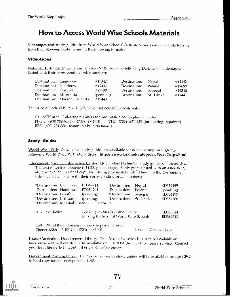
The World Map Project Appendix
How to Access World Wise Schools Materials
Videotapes and study guides from World Wise Schools' Destinaticn series are available for salefrom the following locations and in the following formats:
Videotapes
National Technical Information Service (NTIS) sells the following Destinatitni videotapes(listed with their corresponding order number):
Destination:Destination:Destination:Destination:Destination:
CameroonHondurasI.esothoLithuaniaMarshall Islands
A19347A19444A i 9530(pending)A19443
Destination:Destination:Destination:Destination:
The price of each VHS tape is $25, which reflects NTIS' costs only.
Nepal A19442Poland A19690Senegal 119346Sri Lanka A19441
Call NTIS at the following numbers for information and to place an order:Phone: (800) 788-6282 or (703) 487-4650 TTD: (703) 487-4639 (for hearing impaired)BBS: (800) 234-8861 (computer bulletin board)
Study Guides
World Wide Web: Destination study guides are available for downloading through thefollowing World Wide Web site address: http://www.clark.net/pub/peace/PeaceCorps.html
Educational Resource Information Center (ERI(') offers Destination study guides on microfiche.Tile cost of each microfiche is $1.23, plus postage. Study guides listed with an asterisk (*)are also available in hard copy form for approximately $10. These are the Destinationtitles available, listed with their corresponding order numbers:
*Destination:Destination:
*Destination:*Destination:*Destination:
Cameroon FD36971 1 *Destination:Honduras F D354201 Destination:1.esotho (pend ing) *Destination:I.ithuania (pending) Destination:Marshall Islands ED354198
NepalPolandSenegalSri Lanka
Also available: 1.00king at Oursek es and OthersMaking the Most of World lVise Schools
Call ERIC at the following numbers to place an order:Phone: (800) 443-F RIC. or (7(13) 440-1 :0)
ED354199(pending)ED354197ED354200
ED358024ED369712
Fax: (703) 440-1408
Kraus Curriculum Development Library: The De4tination series is currently available onmicrofiche and %Yin eventually be available on CD-RM1 through this library service. ContactYour local library to find out it it offers Kraus' resources.
Government Printing 011 ice: The De<tination ,,eries study guides will be available through GPOin hard copy form as of September 1995.
7
Peace C orps 73 World Wise Schools
The World Map Project Appendix
Acknowledgments
Special thanks to the following individuals and groups for their contributions to this specialproject:
To Cheryl Bartz and Jennifer Haas of the National Peace Corps Association; the West Cascade(Oregon) Returned Volunteers; and Steve Dorage and the Returned Peace Corps Volunteers ofAtlanta for their commitment to this project.
To Judy Babbits (Peace Corps Fellows), Judy Benjamin (Peace Corps Information Collection andExchange), Tom Burwell (DC RPCVs), Susan Matulaitis (World Wise Schools), and MaureenWilson-Jarrard (World Wise Schools) for their time and suggestions.
To Tom Ahnemann, Andrew Fontanez, and Brian Lonardo for their support and computer layout.
To the World Wise Schools Educational Reviewers: Margaret (Peggy) Altoff (Caro II CountyBoard of Education), Frederick Czarra (Council of Chief State School Officers), Minnie Dyer (DCPublic Schools), Carla Fletcher (Fairfax County Schools), Jayne Osgood (Association forSupervision and Curriculum Development), and Kurt Waters (Fairfax County Schools) for theircritical review and invaluable feedback.
To the National Geographic Society for use of the map of the world.
To the thousands of schoolchildren aitd Peace Corps Volunteers around the world who have madethe map project work, especially Returned Peace Corps Volunteer Barbara Jo (B.J.) White for hervision and illustrations. The Map Project is her gift to the world.
* MS. GOVERNMENT PRINTING OFFICE: 1995 - 622-695 - 1302/82181
7S
Peace Corps 74 World Wise Schools
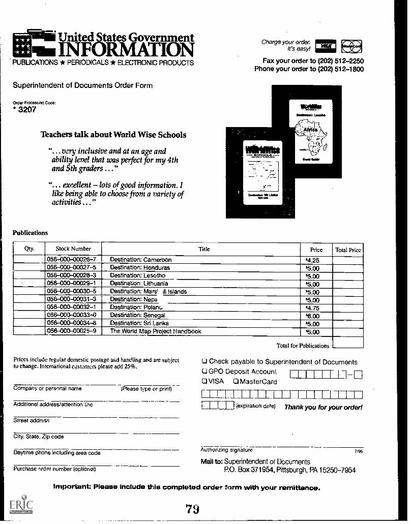
United States GovenunentINFORMATION
PUBLICATIONS * PERIODICALS * ELECTRONIC PRODUCTS
Superintendent of Documents Order Form
Order Processing Code:
* 3207
Teachers talk about World Wise Schools
"...very inclusive and at an age andability level that was pelect for my 4thand 5th graders .. ."
". .. excellent - lots of good information. Ilike being able to choose from a variety ofactivities . . ."
Publications
Charge your orderIt's easy!
Pairog0114.141101
Fax your order to (202) 512-2250Phone your order to (202) 512-1800
11.11ftalker MONO
Osellrallen. Lima*
AT7t21-a-t
Qty. Stock Number Title Price Total Price
056-000-00026-7 Destination: Cameroon $4.25056-000-00027-5 Destination: Honduras $5.00056-000-00028-3 Destination: Lesotho $5.00056-000-00029-1 Destination: Lithuania 85.00056-000-00030-5 Destination: Mars' Ill Islands s5.00056-000-00031-3 Destination: Neva 35.00056-000-00032-1 Destination: Polan(. $4.75056-000-00033-0 Destination: Senegal $6.00056-000-00034-8 Destination: Sri Lanka $5.00056-000-00025-9 The World Map Project Handbook 15.00
Prices include regular domestic postage and handling and are subjecttu change. International customers please add 25%.
Company or personal name (Please type or print)
Additional address/attention line
Street addresr,
City, State, Zip code
Daytime phone including area code
Purchase order number (optional)
Total for Publications
CI Check payable to Superintendent of Documents
U GPO Deposit AccountCI VISA CI MasterCard
[ji LL T TILL11
I I I I l-n
I (expiration date) Thank you for your order!
At7t1i-671-zg signature 7/95
Mail to: Superintendent ot DocumentsP.O. Box 371954, Pittsburgh, PA 15250-7954
important: Please include this completed order form with your remittance.
79
9
I SBN 0-16-042642-1
80
1