Embed Size (px)
Citation preview
Page 1 of 28
Page 2 of 28
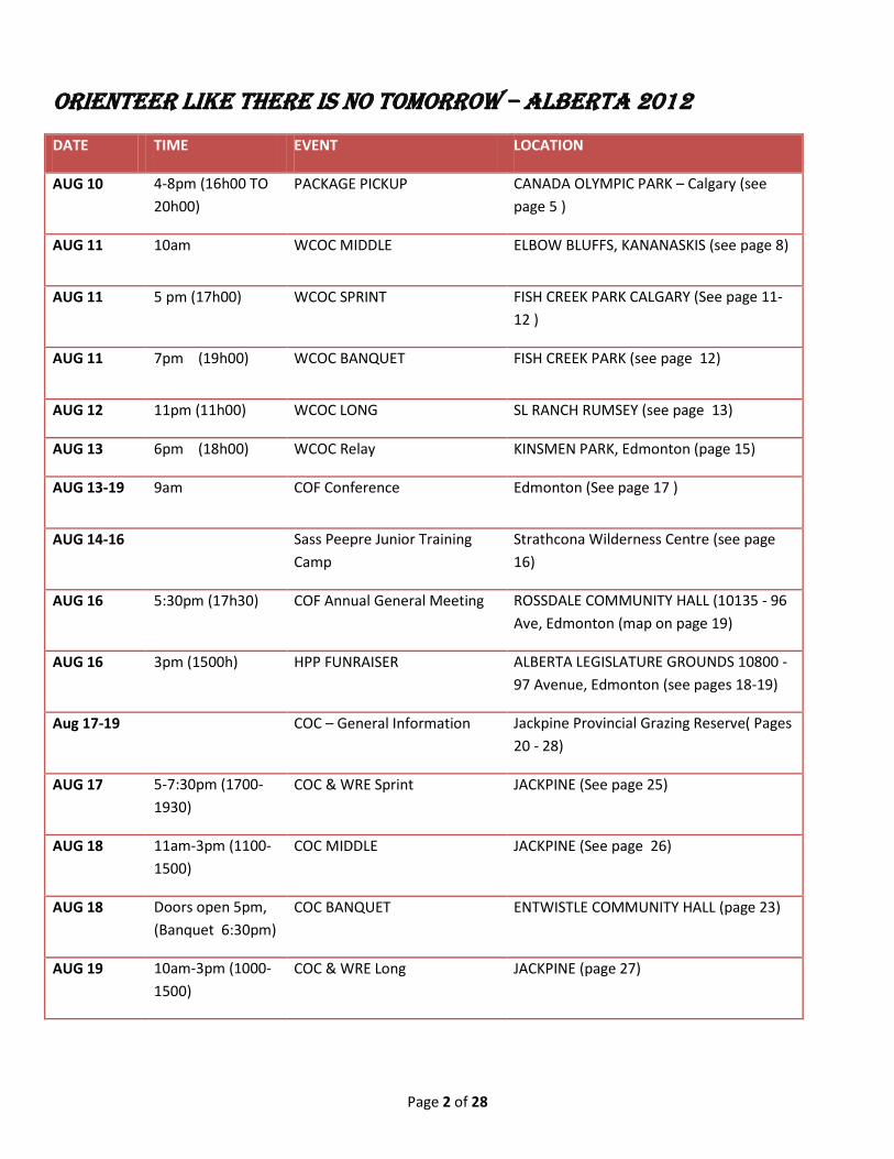
ORIENTEER LIKE THERE IS NO TOMORROW – ALBERTA 2012
DATE TIME EVENT LOCATION
AUG 10 4-8pm (16h00 TO 20h00)
PACKAGE PICKUP CANADA OLYMPIC PARK – Calgary (see page 5 )
AUG 11 10am WCOC MIDDLE ELBOW BLUFFS, KANANASKIS (see page 8)
AUG 11 5 pm (17h00) WCOC SPRINT FISH CREEK PARK CALGARY (See page 11-12 )
AUG 11 7pm (19h00) WCOC BANQUET FISH CREEK PARK (see page 12)
AUG 12 11pm (11h00) WCOC LONG SL RANCH RUMSEY (see page 13)
AUG 13 6pm (18h00) WCOC Relay KINSMEN PARK, Edmonton (page 15)
AUG 13-19 9am COF Conference Edmonton (See page 17 )
AUG 14-16 Sass Peepre Junior Training Camp
Strathcona Wilderness Centre (see page 16)
AUG 16 5:30pm (17h30) COF Annual General Meeting ROSSDALE COMMUNITY HALL (10135 - 96 Ave, Edmonton (map on page 19)
AUG 16 3pm (1500h) HPP FUNRAISER ALBERTA LEGISLATURE GROUNDS 10800 - 97 Avenue, Edmonton (see pages 18-19)
Aug 17-19 COC – General Information Jackpine Provincial Grazing Reserve( Pages 20 - 28)
AUG 17 5-7:30pm (1700-1930)
COC & WRE Sprint JACKPINE (See page 25)
AUG 18 11am-3pm (1100-1500)
COC MIDDLE JACKPINE (See page 26)
AUG 18 Doors open 5pm, (Banquet 6:30pm)
COC BANQUET ENTWISTLE COMMUNITY HALL (page 23)
AUG 19 10am-3pm (1000-1500)
COC & WRE Long JACKPINE (page 27)
Page 3 of 28
Page 4 of 28
August, 2012
Hello Orienteers,
On behalf of the Alberta Orienteering Association I would like to welcome you all to Alberta for the Western and Canadian Orienteering Championships. The course setters have organized a wonderful suite of courses for you both in the foothills of the south and in the grazing lands further north where you can enjoy that big (and of course it will be blue) Alberta sky as you run over the grasslands and through the woods.
To contrast the time on the open prairie, we hope you will take an urban break and participate in the relay on August 13th, and then the never-before-in-Canada ultra sprint on August 16th in Edmonton, organized as the high performance program fundraiser. This fundraiser is the only event where you can keep trying to improve your qualifying time as long as your wallet holds out! Aside from the great orienteering opportunities there are the banquets, associated COF events, and the COF annual general meeting to take in. Finally, it was great to see that the Sass Peepre junior training camp was sold out: all those juniors surely inspired by Emily Kemp’s bronze medal at JWOC.
All the organizers and volunteers sincerely wish you have a great time and success out on your courses. The organizers had several large challenges in putting on these events, but in the true orienteering spirit everyone rose to the occasion to provide you with some great races and hopefully some even better memories (although a beer or two for the meet directors, once the final competitor finishes, might be welcome).
Good luck everyone!
Kim Kasperski
President, Alberta Orienteering Association
Page 5 of 28
GENERAL INFORMATION
Event Package Pick up Friday, Aug 10, at Canada Olympic Park, 4 to 8 pm - to pick up race packages, competitors' handbooks, T shirts, and any other important info. Activities available at COP if you’re arriving earlier on Friday; check out their webpage. Consider a visit to the Canada's Sports Hall of Fame, www.sportshall.ca, which is open until 5:00 pm.
Directions: Canada Olympic Park is on the west side of Calgary on the Trans-Canada Highway (#1). Take the highway west past Sarcee Trail and take the next left at the traffic lights. (There’s a PetroCan station on your right.) Follow the signs to the Canada Sports Hall of Fame at the far west end of the Park and park in the lot to the West of the (red) building. Follow the orienteering controls/signs to the large grey building to the north. We are in the Shane room near the cafeteria, which is open until 7 pm.
Any remaining packages may be picked up at the High Performance Fundraiser or COF Annual General meeting on Thursday, August 16, or at the registration and information tent at the assembly area for each race.
Awards and Eligibility
Canadian Orienteering Championships: For each competitive class, medals will be awarded to the top three eligible Canadian competitors. Prizes will be also give to the top overall WRE winners. To be eligible for the COC medals you must be a full member of a provincial/territorial organization affiliated with the Canadian Orienteering Federation and either a Canadian Citizen or a Permanent Resident as defined by the Department of Citizenship and Immigration.
Western Canadian Orienteering Championships: For each competitive class, medals will be awarded to the top three eligible Western Canadian competitors.. To be eligible for the WCOC medals you must be a full member of a provincial/territorial organization affiliated with the Canadian Orienteering Federation and either a Canadian Citizen or a Permanent Resident as defined by the Department of Citizenship and Immigration residing in Alberta, British Columbia, Manitoba, Saskatchewan or the Yukon Territory
Banquets
Advance ticket purchase was required for Banquets. WCOC Banquet – Fish Creek Park, August 11th following the Sprint (see WCOC Sprint Pages). COC Banquet – Entwistle Community Hall Sat August 18 (see COC pages)
Car Pooling
Car pooling /shuttling for the WCOC Middle – see individual event page for details. We encourage you to get to know your competitors and car pool from your hotel/campsite when at all possible.
Cell phones
Limited coverage at some venues for Rogers users. Telus/Bell coverage appears to be available at all event, although the terrain can interfere.
Changes
Changes to age categories or start times cannot be accommodated. It is the responsibility of the competitor to know his start time and to show up on time. No new start times will be given to late competitors. See START Procedures.
Clothing Return
Clothing Return is available at venues where the start is not located close to the finish arena. Please be considerate of the volunteers who carry your items!
Page 6 of 28
Complaints & Protest Procedures
The organizers strive to ensure that everything goes smoothly. In the event that you encounter a problem please follow this procedure: 1) Speak to an official about your problem as soon as possible. 2) If after this discussion you wish to formally pursue your problem then please lodge a complaint by completing the first section of the complaint/protest form (available at the finish area) and submit the form to the meet director or course planner. 3) The organizers will meet and provide their written response to the complaint. 4) If you are not satisfied with the organizers’ response, you may lodge a formal protest by completing the third section of the form and submit the form to the event controller or WRE Advisor who will convene a jury meeting to rule on the protest. A written response will be provided. Please note that protests against rule infringements must be lodged within 30 minutes after the course closes. Protests against the provisional results must be lodged within one hour after they are posted. Official protest fee is $50 which will be refunded if your protest is upheld.
Jury Pool:
2012 WCOC (Sprint, Middle & Long) :Muriel Gamey, Barbara Scheck, Richard Guttormson; WCOC Relay: Dave Graupner, David Ross, Bill Anderson
2012 COC Jury Pool (all events): Bill Anderson, Ross Burnett, Marg Ellis, Alex Kerr, David Ross, Lois Watts
Course Descriptions
Course descriptions will be printed on the front of all maps. Course 1 maps will have both IOF symbols and written descriptive English language. Course 2 and up will use IOF control description symbols. Loose control descriptions will be available at the start line.
Course Closure Times
All competitors must cross the finish line and report back to the download area prior to course closure listed for each event. This is a safety feature ensuring all competitors have safely returned otherwise a search party may be initiated.
Disqualifications
A competitor with one or more missing punches will be disqualified and the results listed a MP (missed punch). This will also be the case for a competitor using a SI card that is different than is listed in the registration. Ensure event organizers have your correct SI card number on your registration package.
A competitor out on the course beyond course maximum time will be recorded at OT. A competitor will have DSQ for al other disqualifications.
Fences
There are a number of fences on the map and the gates shown on the map will be open. In a few places marked with the crossing symbol the fence has been made easier to cross. If crossing fences at other locations PLEASE DO NOT CLIMB ON THE FENCE, rolling under is usually easier than going between the barbed wires.
Finish
All runners must pass through the finish line and report to the finish area to download, whether you have completed the whole course or not. This is a safety feature. The organizers must know that all competitors have safely come out of the forest or they may need to initiate a search party
First Aid
First Aid is available at each event venue. Please take time to locate the Safety Chief’s first aid tent when you arrive.
Food
Page 7 of 28
Please bring a lunch as there are no food concessions at the meet sites. Refreshments and snacks for finishers available following the download stations.
Lost and Found
Located at the registration area.
Silent Auction
Annual silent auction to be at COC Banquet in support of our High performace program. Please bring cash or cheque book & enjoy the fun bidding for great & varied items.
Start Procedures
All events will follow the 3 line start procedures with pre-assigned start times. It is the responsibility of the competitor to arrive to the first line on time. Clear & Check your SI unit before the call up line.
Call up line – 3 minutes before actual start time ( name,SI # & whistle check)
Control Description Line – competitors may affix loose control description s
Start line – Map pick up & official timing begins
Late starters must report to the start line, where they will be slotted by the start chief.
Important NOTE:
The run from the start line to the start triangle is considered a mandatory route. The competitor must go to the start triangle before starting their course. Late starters will not be issued new start times. Late starters will proceed through grid accompanied by a start official, at a time that will not interfere with other starters.
TIMING
All events use the SPORTident electronic punching system. It is important that you always have a individual unique SI-card. You will not be allowed to start unless the number on your SI-card matches the number in our start database (which is printed on your registration package and bib). Please report changes in SI number to registration officials.
Page 8 of 28
2012 Western Canadian Orienteering Championships Due to access issues beyond our control & not the Mayan Curse, our organizing committee was forced to change venues. Please see the individual event pages for driving directions and course planner notes.
Thank you to our very flexible meet director, course planners & volunteers for this event! It took creative magic to pull this off one year earlier than planned. Truly a great team of volunteers!
2012 WCOC Officials
Western Canadian Orienteering Championships Meet Director - Clarence Kort
Start Chief – Marsh Fehr Finish/Timing – Richard Obrietor
Course Planners – Middle: Don Bayly, Sprint: JP Buysschaert, Long: Marion Owen
Controllers – Middle & Sprint: Bill Jarvis, Long: Greg Yarkie
WCOC Middle Event
Map Details: Elbow Bluffs ISOM 2000 Standard
Contour Interval 5m Scale 1:10:000 except for Courses 4 and 5 which will be at 1:7,500
Mapper: Bryan Chubb 2006, minor revisions Don Bayle 2012
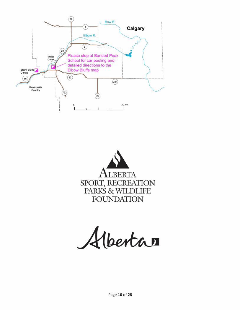
First Start: 10 am. Competitors will have 180 minutes to complete their course. Course closure is anticipated to be at 1400hrs. Directions to the WCOC Middle Distance Event Saturday August 11, 2012 Parking & car pooling site is at the Banded Peak School on the west side of Highway 22, 2 km south of Bragg Creek. Latitude: 50 degrees 56.08 minutes N Longitude: 114 degrees 33.69 W UTM Zone 11, 671 340 m East, 5645 396 m N From central Calgary, go west on Highway 1. Exit for Highway 22 south to Bragg Creek. You will encounter the traffic circle at the Highway 8/Highway 22 junction. Take the branch that continues south to Bragg Creek. At the four-way stop in Bragg Creek, go left (south) 1.8 km to Banded Peak School. Alternate route from SW Calgary: Go west on Highway 8 to the traffic circle at Highway 22, then take 22 south to Bragg Creek. At the four-way stop in Bragg Creek, go left (south) 1.8 km to Banded Peak School. Alternate route if arriving from Highway 2 on the south side of Calgary: Go west on Highway 22X. At the Highway 22 / 22X junction continue west on Highway 22. At the Highway 22 / 66 junction turn right (north) and go 1.6 km to Banded Peak School. Car Pooling from Banded Peak School to the event site will start running at about 8:30 AM. Estimated time on the bus is ten to fifteen minutes. There is a 1.7 km walk from the parking/ dropoff point to the start.
WCOC Middle Event - Elbow Bluffs - Course Setter’s Notes
Page 9 of 28
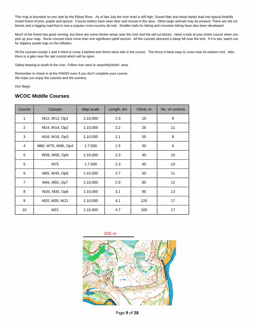
This map is bounded on one side by the Elbow River. As of late July the river level is still high. Gravel flats and steep banks lead into typical foothills mixed forest of pine, poplar and spruce. Course setters have seen deer and moose in the area. Other large animals may be present. There are old cut blocks and a logging road that is now a popular cross-country ski trail. Smaller trails for hiking and mountain biking have also been developed. Much of the forest has good running, but there are some thicker areas near the river and the old cut blocks. Have a look at your entire course when you pick up your map. Some courses have more than one significant uphill section. All the courses descend a steep hill near the end. If it is wet, watch out for slippery poplar logs on the hillsides. All the courses except 1 and 4 need to cross a barbed wire fence twice late in the course. The fence is fairly easy to cross near its eastern end. Also there is a gate near the last control which will be open.
Safety bearing is south to the river. Follow river west to assembly/finish area.
Remember to check in at the FINISH even if you don’t complete your course. We hope you enjoy the courses and the scenery.
Don Bayly WCOC Middle Courses
Course Classes Map scale Length, km Climb, m No. of controls
1 M12, W12, Op1 1:10,000 2.3 15 9
2 M14, W14, Op2 1:10,000 2.2 25 11
3 M16, W16, Op3 1:10,000 2.1 55 8
4 M80, W75, W80, Op4 1:7,500 1.5 30 6
5 W55, W65, Op5 1:10,000 2.3 45 10
5 M75 1:7,500 2.3 45 10
6 M65, W45, Op6 1:10,000 2.7 50 11
7 M45, M55, Op7 1:10,000 2.9 85 12
8 W20, M35, Op8 1:10,000 3.1 95 13
9 M20, M35, W21 1:10,000 4.1 120 17
10 M21 1:10,000 4.7 165 17
Page 10 of 28
Page 11 of 28
WCOC - Sprint Event
Map - Fish Creek ISSOM Map Scale: 1:5000 Contour Interval 2.5 meter contours Mapper: Sarah Brandreth 2009
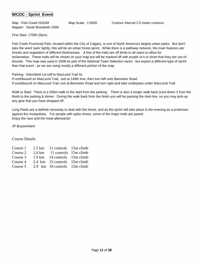
First Start: 1700h (5pm). Fish Creek Provincial Park, located within the City of Calgary, is one of North America's largest urban parks. But don't take the word 'park' lightly, this will be an urban forest sprint. While there is a pathway network, the main features are forests and vegetation of different thicknesses. A few of the trails are off limits to all users to allow for reclamation. These trails will be shown on your map but will be marked off with purple xx's to show that they are out-of-bounds. This map was used in 2009 as part of the National Team Selection races - but expect a different type of sprint than that event - as we are using mostly a different portion of the map. Parking: Glennfield Lot (off to MacLeod Trail S). If northbound on MacLeod Trail, exit at 149th Ave, then turn left onto Bannister Road If southbound on MacLeod Trail, exit at Bannister Road and turn right and take underpass under MacLeod Trail. Walk to Start: There is a 500m walk to the start from the parking. There is also a longer walk back (cool down !) from the finish to the parking & dinner. During the walk back from the finish you will be passing the start-line, so you may pick-up any gear that you have dropped off. Long Pants are a definite necessity to deal with the forest, and as the sprint will take place in the evening as a protection against the mosquitoes. For people with spike shoes, some of the major trails are paved. Enjoy the race and the meal afterwards!
JP Buysschaert
Course Details Course 1 1.5 km 11 controls 15m climb Course 2 1,6 km 11 controls 15m climb Course 3 1.9 km 14 controls 15m climb Course 4 2.4 km 15 controls 15m climb Course 5 2.9 km 18 controls 15m climb
Page 12 of 28
WCOC Sprint Parking & WCOC Feast Location Map
Page 13 of 28
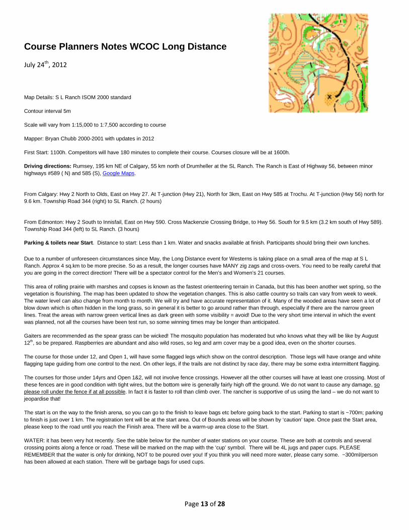
Course Planners Notes WCOC Long Distance
July 24th, 2012
Map Details: S L Ranch ISOM 2000 standard
Contour interval 5m
Scale will vary from 1:15,000 to 1:7,500 according to course
Mapper: Bryan Chubb 2000-2001 with updates in 2012
First Start: 1100h. Competitors will have 180 minutes to complete their course. Courses closure will be at 1600h.
Driving directions: Rumsey, 195 km NE of Calgary, 55 km north of Drumheller at the SL Ranch. The Ranch is East of Highway 56, between minor highways #589 ( N) and 585 (S), Google Maps.
From Calgary: Hwy 2 North to Olds, East on Hwy 27. At T-junction (Hwy 21), North for 3km, East on Hwy 585 at Trochu. At T-junction (Hwy 56) north for 9.6 km. Township Road 344 (right) to SL Ranch. (2 hours)
From Edmonton: Hwy 2 South to Innisfail, East on Hwy 590. Cross Mackenzie Crossing Bridge, to Hwy 56. South for 9.5 km (3.2 km south of Hwy 589). Township Road 344 (left) to SL Ranch. (3 hours)
Parking & toilets near Start. Distance to start: Less than 1 km. Water and snacks available at finish. Participants should bring their own lunches.
Due to a number of unforeseen circumstances since May, the Long Distance event for Westerns is taking place on a small area of the map at S L Ranch. Approx 4 sq.km to be more precise. So as a result, the longer courses have MANY zig zags and cross-overs. You need to be really careful that you are going in the correct direction! There will be a spectator control for the Men’s and Women’s 21 courses.
This area of rolling prairie with marshes and copses is known as the fastest orienteering terrain in Canada, but this has been another wet spring, so the vegetation is flourishing. The map has been updated to show the vegetation changes. This is also cattle country so trails can vary from week to week. The water level can also change from month to month. We will try and have accurate representation of it. Many of the wooded areas have seen a lot of blow down which is often hidden in the long grass, so in general it is better to go around rather than through, especially if there are the narrow green lines. Treat the areas with narrow green vertical lines as dark green with some visibility = avoid! Due to the very short time interval in which the event was planned, not all the courses have been test run, so some winning times may be longer than anticipated.
Gaiters are recommended as the spear grass can be wicked! The mosquito population has moderated but who knows what they will be like by August 12th, so be prepared. Raspberries are abundant and also wild roses, so leg and arm cover may be a good idea, even on the shorter courses.
The course for those under 12, and Open 1, will have some flagged legs which show on the control description. Those legs will have orange and white flagging tape guiding from one control to the next. On other legs, if the trails are not distinct by race day, there may be some extra intermittent flagging.
The courses for those under 14yrs and Open 1&2, will not involve fence crossings. However all the other courses will have at least one crossing. Most of these fences are in good condition with tight wires, but the bottom wire is generally fairly high off the ground. We do not want to cause any damage, so please roll under the fence if at all possible. In fact it is faster to roll than climb over. The rancher is supportive of us using the land – we do not want to jeopardise that!
The start is on the way to the finish arena, so you can go to the finish to leave bags etc before going back to the start. Parking to start is ~700m; parking to finish is just over 1 km. The registration tent will be at the start area. Out of Bounds areas will be shown by ‘caution’ tape. Once past the Start area, please keep to the road until you reach the Finish area. There will be a warm-up area close to the Start.
WATER: it has been very hot recently. See the table below for the number of water stations on your course. These are both at controls and several crossing points along a fence or road. These will be marked on the map with the ‘cup’ symbol. There will be 4L jugs and paper cups. PLEASE REMEMBER that the water is only for drinking, NOT to be poured over you! If you think you will need more water, please carry some. ~300ml/person has been allowed at each station. There will be garbage bags for used cups.
Page 14 of 28
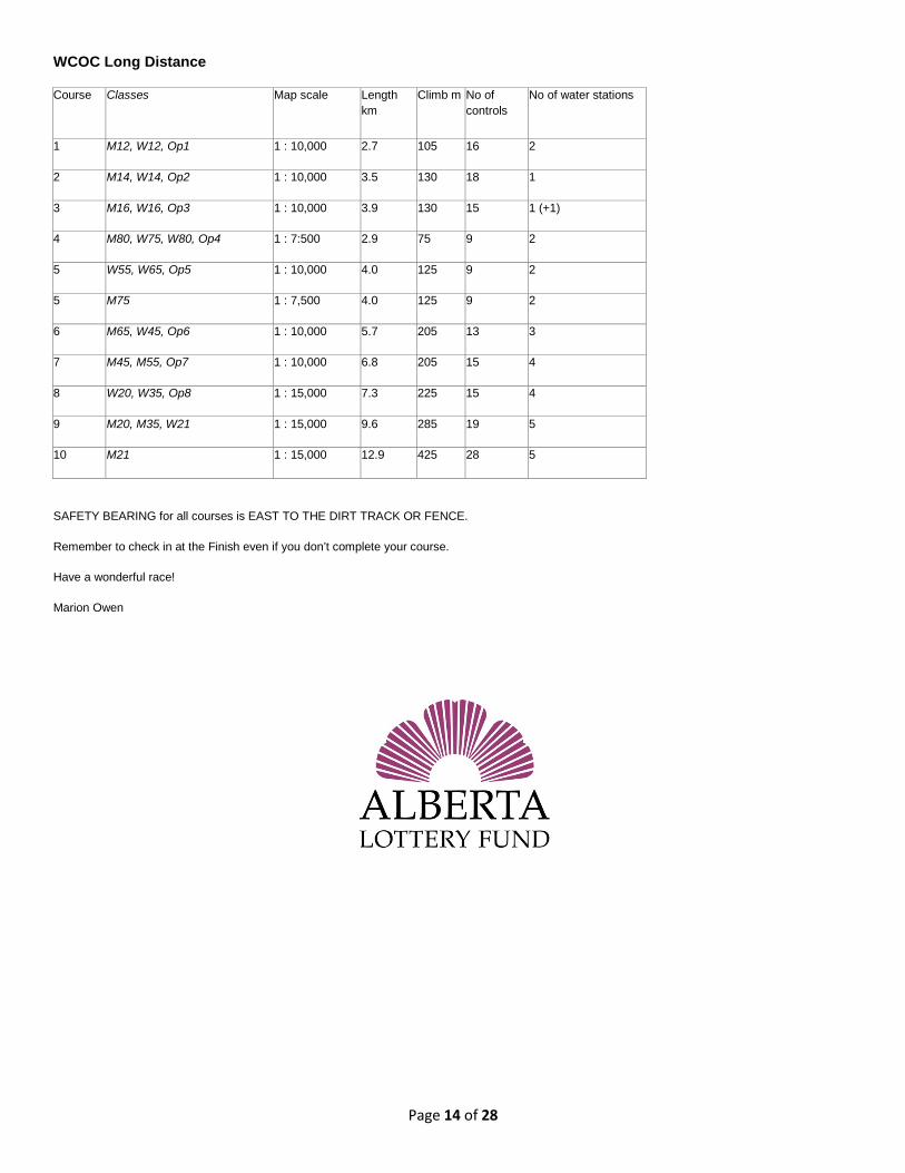
WCOC Long Distance
Course Classes Map scale Length km
Climb m No of controls
No of water stations
1 M12, W12, Op1 1 : 10,000 2.7 105 16 2
2 M14, W14, Op2 1 : 10,000 3.5 130 18 1
3 M16, W16, Op3 1 : 10,000 3.9 130 15 1 (+1)
4 M80, W75, W80, Op4 1 : 7:500 2.9 75 9 2
5 W55, W65, Op5 1 : 10,000 4.0 125 9 2
5 M75 1 : 7,500 4.0 125 9 2
6 M65, W45, Op6 1 : 10,000 5.7 205 13 3
7 M45, M55, Op7 1 : 10,000 6.8 205 15 4
8 W20, W35, Op8 1 : 15,000 7.3 225 15 4
9 M20, M35, W21 1 : 15,000 9.6 285 19 5
10 M21 1 : 15,000 12.9 425 28 5
SAFETY BEARING for all courses is EAST TO THE DIRT TRACK OR FENCE.
Remember to check in at the Finish even if you don’t complete your course.
Have a wonderful race!
Marion Owen
Page 15 of 28
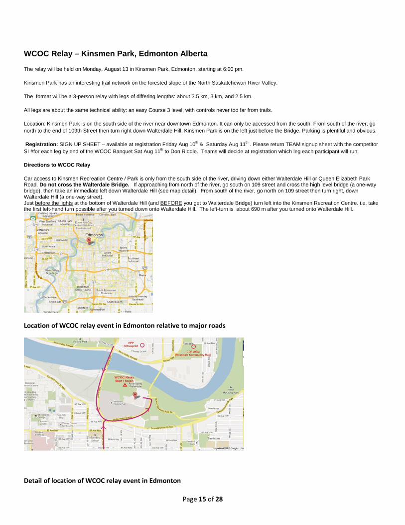
WCOC Relay – Kinsmen Park, Edmonton Alberta
The relay will be held on Monday, August 13 in Kinsmen Park, Edmonton, starting at 6:00 pm.
Kinsmen Park has an interesting trail network on the forested slope of the North Saskatchewan River Valley.
The format will be a 3-person relay with legs of differing lengths: about 3.5 km, 3 km, and 2.5 km.
All legs are about the same technical ability: an easy Course 3 level, with controls never too far from trails.
Location: Kinsmen Park is on the south side of the river near downtown Edmonton. It can only be accessed from the south. From south of the river, go north to the end of 109th Street then turn right down Walterdale Hill. Kinsmen Park is on the left just before the Bridge. Parking is plentiful and obvious.
Registration: SIGN UP SHEET – available at registration Friday Aug 10th & Saturday Aug 11th . Please return TEAM signup sheet with the competitor SI #for each leg by end of the WCOC Banquet Sat Aug 11th to Don Riddle. Teams will decide at registration which leg each participant will run.
Directions to WCOC Relay
Car access to Kinsmen Recreation Centre / Park is only from the south side of the river, driving down either Walterdale Hill or Queen Elizabeth Park Road. Do not cross the Walterdale Bridge. If approaching from north of the river, go south on 109 street and cross the high level bridge (a one-way bridge), then take an immediate left down Walterdale Hill (see map detail). From south of the river, go north on 109 street then turn right, down Walterdale Hill (a one-way street). Just before the lights at the bottom of Walterdale Hill (and BEFORE you get to Walterdale Bridge) turn left into the Kinsmen Recreation Centre. i.e. take the first left-hand turn possible after you turned down onto Walterdale Hill. The left-turn is about 690 m after you turned onto Walterdale Hill.
Location of WCOC relay event in Edmonton relative to major roads
Detail of location of WCOC relay event in Edmonton
Page 16 of 28
2012 SASS PEEPRE JUNIOR TRAINING CAMP STRATHCONA WILDERNESS CENTRE
ARRIVAL Tuesday, August 14 Participants and coaches should arrive between noon and 1:00pm. Please do not arrive before noon unless Kitty specifically requests you to do so. Upon arrival, you must check in with Marsha. Everyone must bring their own lunch/snacks/water/drinks for Tuesday, August 14. Arrive dressed to orienteer.
DIRECTIONS TO CAMP Go here to see the location map of the Strathcona Wilderness Centre: http://www.strathcona.ca/files/attachment-rpc-swc-map.pdf The Strathcona Wilderness Centre is a 20 minute drive east of Sherwood Park. You can ONLY access it from Township Road 530. This road starts in Edmonton as 101 Avenue. Going east, it crosses Anthony Henday Drive (Hwy 216) and at that point it becomes Baseline Road (going through Sherwood Park). At the east edge of Sherwood Park, it crosses Hwy 21 and becomes Township Road 530 (Twp 530). The Centre is on Range Road 212 (RR212), just south of Township Road 530. If you are driving from Calgary or Red Deer, you can avoid both Edmonton and Sherwood Park by taking Highway 21 north, to the east edge of Sherwood Park. Turn right (east) onto Township Road 530 and proceed east until you turn right (south) onto RR212.
DEPARTURE Thursday, August 16 Parents should collect their children at noon. Please do not be late. The HP Program Fundraiser in downtown Edmonton starts at 3:00pm. It is approximately a 30-40 minute drive from camp to this fundraiser event. EMERGENCY CONTACT If there is a serious reason to contact us at camp, either during camp or because you will be late arriving, then you can contact the camp registrar, Marsha Fehr, on her cell at: 403-975-3598 Please send TEXTS ONLY. Phone calls will NOT be answered (too expensive). Please ONLY text Marsha if there is a serious problem.
Page 17 of 28
2012 COF Conference
Mon Aug 13, 9:00 am – 3:00 pm and Tues Aug 14 9:00 am – noon Edmonton
Community Coach clinic This 9 hour workshop covers both the theoretical and technical components needed to coach people newcomers to orienteering. Pre-register for this workshop with Bill Anderson at [email protected]
Monday Aug 13, 3:15 pm Room 3, Percy Page Centre (11759 Groat Road, Edmonton)
Orienteering's Long Term Athlete Development model in action This will be your first chance to get your hands on our brand-new LTAD booklet. The orienteering-specific LTAD model gives guidelines for how best to deliver orienteering to all the different levels and age groups in the most effective and engaging manner. Our task now is to incorporate these guidelines in our coaching, officiating and junior and adult beginner programming. This session is a perfect fit for the volunteers who will be helping to coach at the Sass Peepre camp as well at those involved with introducing orienteering to newcomers at their club events.
Tuesday Aug 14, 8:00 pm Strathcona Wilderness Centre
Looking back at JWOC 2012 Join members of the 2012 national junior orienteering team, including JWOC bronze medallist Emily Kemp, as they recount their races and experiences at the 2012 junior world championships held in Slovakia in early July. This session will be held in conjunction with the Sass Peepre junior camp. All are welcome. (Arrive at entrance gate to Strathcona Wilderness Centre between 7:45-8:00pm. This gate will be locked before and after this time window. You can ONLY access Strathcona Wilderness Centre from Township Road 530. It is a 20 minute drive east of Sherwood Park, at the junction of Twp530 and RR212.)
Wed Aug 15, 8:00 pm Strathcona Wilderness Centre
Looking back at WOC 2012 Join members of the 2012 national senior orienteering team as they recount their races and experiences at the 2012 world championships held in Switzerland in July. This session will be held in conjunction with the Sass Peepre junior camp. All are welcome. (Arrive at entrance gate to Strathcona Wilderness Centre between 7:45-8:00pm. This gate will be locked before and after this time window. You can ONLY access Strathcona Wilderness Centre from Township Road 530. It is a 20 minute drive east of Sherwood Park, at the junction of Twp530 and RR212.)
Thurs Aug 16 11:00 am Rossdale Community Hall (10135 - 96 Ave, Edmonton)
The latest from the COF Come and find out about what projects are being working on at the COF and how they make a difference to your club – projects such as the national event database, our Sport Canada recognition, COF hiring plans, the officials and coaching programs, Project 5000, updated the course and category guidelines.
Thurs Aug 16 1:00 pm Rossdale Community Hall (10135 - 96 Ave, Edmonton)
Orienteering and crowdSPRING: A case study This is a repeat engagement of a fascinating presentation that Edmonton orienteer Sherry Haley about the process used to create the new Alberta Orienteering Association logo using crowdSPRING, a crowd sourcing website. The idea was to publish a request for a logo design onto the crowdSPRING website where it would be reviewed by various graphic designers. A financial prize was offered for the winning design, and a number of parameters were given for the logo. Come and see how it all turned out – and find out how to use resources like CrowdSource and Elance to develop club and event logos and various graphic design needs.
Thurs Aug 16 5:30 pm Rossdale Community Hall (10135 - 96 Ave, Edmonton)
Annual General Meeting The AGM is the one time of year when representatives of the Provincial and Territorial Associations gather to discuss and decide on the business tasks of the Canadian Orienteering Federation (such as electing board members, making changes to the constitution, reviewing the financial statements, etc). All are welcome to attend, though only the Associations' confirmed representatives will be able to vote. All the details are www.orienteering.ca
Thurs Aug 16 7:30 pm Rossdale Community Hall (10135 - 96 Ave, Edmonton)
A PechaKucha evening Have you heard of PechaKucha? It's a presentation methodology in which 20 slides are shown for 20 seconds each for a max of 6 minutes, 40 seconds/presenter. There will be between six and ten different presenters on a wide range of orienteering related topics. Each presentation will be short and sweet and there will be a big variety. Join us for this fun evening. The topics will be listed on www.orienteering.ca/2012/06/2012-cof-conference so check there for the latest list of topics and presenters.
Fri Aug 17 10:00 am Rossdale Community Hall (10135 - 96 Ave, Edmonton)
Junior Development in Canada Three Canadian orienteers were contracted to collect information about junior programs across the country and around the world. Also to collect information about junior programming in other sport. And to develop a pilot project call “Sass Peepre Online” to test methods of offering online training to juniors ages 13-20 who are not currently in the COF’s High Performance Program. This conference session will include a summary of their work and a discussion regarding the next steps in the creation of a national junior orienteering curriculum.
Fri Aug 17 11:30 am Rossdale Community Hall (10135 - 96 Ave, Edmonton)
SportIDENT – the latest and greatest from the SI gang Are you the “SI guy” (or “SI girl”) for your club or organization? If you are, then this session is for you. Or, if you’re interested in techy stuff in general or SI stuff in particular, then you should come as well. You will have the opportunity to learn about the latest ideas and technologies that SportIDENT is adding to its repertoire now and over the year to come. Both the Canadian rep for SportIDENT, Eric Teutsch, and the creator of the SportIDENT system, Siegfried Ritter from Germany, will be on hand to talk about what’s new and coming, and to answer questions about the SI timing system.
Various times between Friday the 17th and Sunday the 19th
Learning Facilitator clinic Are you interested in becoming certified to teach the community coach program? This 5-6 hour session will give you the skills needed to teach the community coach course. Let Bill Anderson ( [email protected] ) know of your interest in this session. We are looking to find a couple hours here and there a few times between the Thursday and Sunday races to make up the whole 5-6 hours.
Page 18 of 28
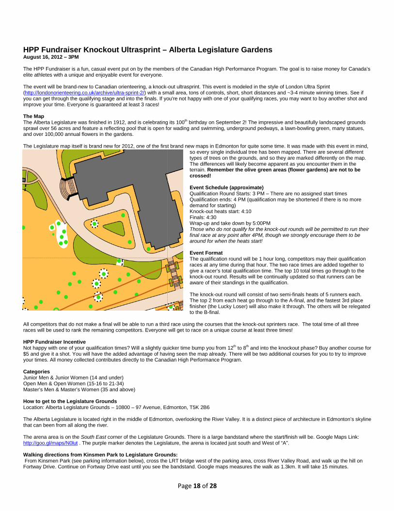
HPP Fundraiser Knockout Ultrasprint – Alberta Legislature Gardens August 16, 2012 – 3PM The HPP Fundraiser is a fun, casual event put on by the members of the Canadian High Performance Program. The goal is to raise money for Canada’s elite athletes with a unique and enjoyable event for everyone. The event will be brand-new to Canadian orienteering, a knock-out ultrasprint. This event is modeled in the style of London Ultra Sprint (http://londonorienteering.co.uk/archive/ultra-sprint-2/) with a small area, tons of controls, short, short distances and ~3-4 minute winning times. See if you can get through the qualifying stage and into the finals. If you're not happy with one of your qualifying races, you may want to buy another shot and improve your time. Everyone is guaranteed at least 3 races! The Map The Alberta Legislature was finished in 1912, and is celebrating its 100th birthday on September 2! The impressive and beautifully landscaped grounds sprawl over 56 acres and feature a reflecting pool that is open for wading and swimming, underground pedways, a lawn-bowling green, many statues, and over 100,000 annual flowers in the gardens. The Legislature map itself is brand new for 2012, one of the first brand new maps in Edmonton for quite some time. It was made with this event in mind,
so every single individual tree has been mapped. There are several different types of trees on the grounds, and so they are marked differently on the map. The differences will likely become apparent as you encounter them in the terrain. Remember the olive green areas (flower gardens) are not to be crossed! Event Schedule (approximate) Qualification Round Starts: 3 PM – There are no assigned start times Qualification ends: 4 PM (qualification may be shortened if there is no more demand for starting) Knock-out heats start: 4:10 Finals: 4:30 Wrap-up and take down by 5:00PM Those who do not qualify for the knock-out rounds will be permitted to run their final race at any point after 4PM, though we strongly encourage them to be around for when the heats start! Event Format The qualification round will be 1 hour long, competitors may their qualification races at any time during that hour. The two race times are added together to give a racer’s total qualification time. The top 10 total times go through to the knock-out round. Results will be continually updated so that runners can be aware of their standings in the qualification. The knock-out round will consist of two semi-finals heats of 5 runners each. The top 2 from each heat go through to the A-final, and the fastest 3rd place finisher (the Lucky Loser) will also make it through. The others will be relegated to the B-final.
All competitors that do not make a final will be able to run a third race using the courses that the knock-out sprinters race. The total time of all three races will be used to rank the remaining competitors. Everyone will get to race on a unique course at least three times! HPP Fundraiser Incentive Not happy with one of your qualification times? Will a slightly quicker time bump you from 12th to 8th and into the knockout phase? Buy another course for $5 and give it a shot. You will have the added advantage of having seen the map already. There will be two additional courses for you to try to improve your times. All money collected contributes directly to the Canadian High Performance Program. Categories Junior Men & Junior Women (14 and under) Open Men & Open Women (15-16 to 21-34) Master’s Men & Master’s Women (35 and above) How to get to the Legislature Grounds Location: Alberta Legislature Grounds – 10800 – 97 Avenue, Edmonton, T5K 2B6 The Alberta Legislature is located right in the middle of Edmonton, overlooking the River Valley. It is a distinct piece of architecture in Edmonton’s skyline that can been from all along the river. The arena area is on the South East corner of the Legislature Grounds. There is a large bandstand where the start/finish will be. Google Maps Link: http://goo.gl/maps/N0lut . The purple marker denotes the Legislature, the arena is located just south and West of “A”. Walking directions from Kinsmen Park to Legislature Grounds: From Kinsmen Park (see parking information below), cross the LRT bridge west of the parking area, cross River Valley Road, and walk up the hill on Fortway Drive. Continue on Fortway Drive east until you see the bandstand. Google maps measures the walk as 1.3km. It will take 15 minutes.
Page 19 of 28
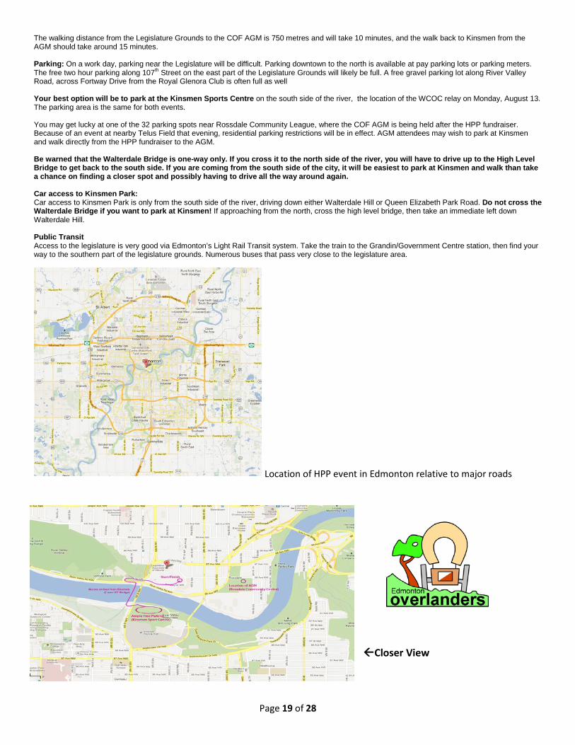
The walking distance from the Legislature Grounds to the COF AGM is 750 metres and will take 10 minutes, and the walk back to Kinsmen from the AGM should take around 15 minutes. Parking: On a work day, parking near the Legislature will be difficult. Parking downtown to the north is available at pay parking lots or parking meters. The free two hour parking along 107th Street on the east part of the Legislature Grounds will likely be full. A free gravel parking lot along River Valley Road, across Fortway Drive from the Royal Glenora Club is often full as well Your best option will be to park at the Kinsmen Sports Centre on the south side of the river, the location of the WCOC relay on Monday, August 13. The parking area is the same for both events. You may get lucky at one of the 32 parking spots near Rossdale Community League, where the COF AGM is being held after the HPP fundraiser. Because of an event at nearby Telus Field that evening, residential parking restrictions will be in effect. AGM attendees may wish to park at Kinsmen and walk directly from the HPP fundraiser to the AGM. Be warned that the Walterdale Bridge is one-way only. If you cross it to the north side of the river, you will have to drive up to the High Level Bridge to get back to the south side. If you are coming from the south side of the city, it will be easiest to park at Kinsmen and walk than take a chance on finding a closer spot and possibly having to drive all the way around again. Car access to Kinsmen Park: Car access to Kinsmen Park is only from the south side of the river, driving down either Walterdale Hill or Queen Elizabeth Park Road. Do not cross the Walterdale Bridge if you want to park at Kinsmen! If approaching from the north, cross the high level bridge, then take an immediate left down Walterdale Hill. Public Transit Access to the legislature is very good via Edmonton’s Light Rail Transit system. Take the train to the Grandin/Government Centre station, then find your way to the southern part of the legislature grounds. Numerous buses that pass very close to the legislature area.
Location of HPP event in Edmonton relative to major roads
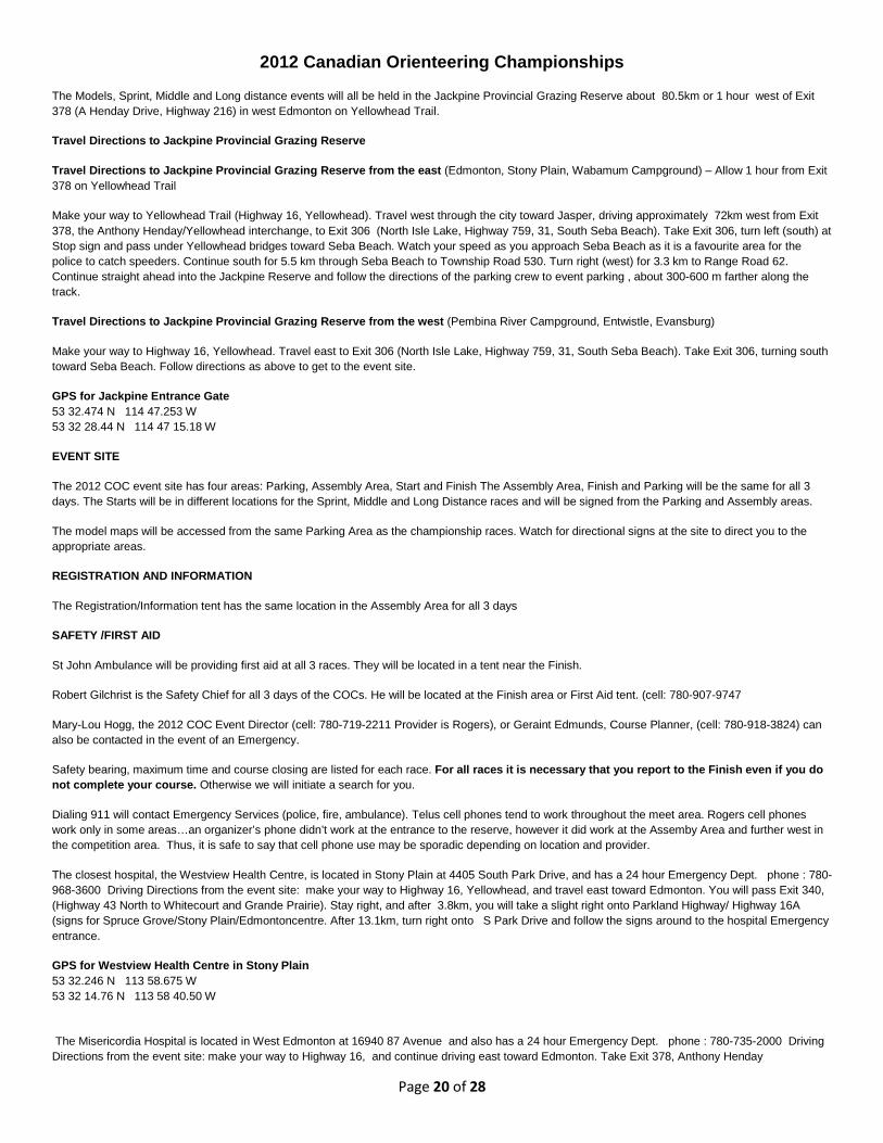
Closer View
Page 20 of 28
2012 Canadian Orienteering Championships
The Models, Sprint, Middle and Long distance events will all be held in the Jackpine Provincial Grazing Reserve about 80.5km or 1 hour west of Exit 378 (A Henday Drive, Highway 216) in west Edmonton on Yellowhead Trail.
Travel Directions to Jackpine Provincial Grazing Reserve
Travel Directions to Jackpine Provincial Grazing Reserve from the east (Edmonton, Stony Plain, Wabamum Campground) – Allow 1 hour from Exit 378 on Yellowhead Trail
Make your way to Yellowhead Trail (Highway 16, Yellowhead). Travel west through the city toward Jasper, driving approximately 72km west from Exit 378, the Anthony Henday/Yellowhead interchange, to Exit 306 (North Isle Lake, Highway 759, 31, South Seba Beach). Take Exit 306, turn left (south) at Stop sign and pass under Yellowhead bridges toward Seba Beach. Watch your speed as you approach Seba Beach as it is a favourite area for the police to catch speeders. Continue south for 5.5 km through Seba Beach to Township Road 530. Turn right (west) for 3.3 km to Range Road 62. Continue straight ahead into the Jackpine Reserve and follow the directions of the parking crew to event parking , about 300-600 m farther along the track.
Travel Directions to Jackpine Provincial Grazing Reserve from the west (Pembina River Campground, Entwistle, Evansburg)
Make your way to Highway 16, Yellowhead. Travel east to Exit 306 (North Isle Lake, Highway 759, 31, South Seba Beach). Take Exit 306, turning south toward Seba Beach. Follow directions as above to get to the event site.
GPS for Jackpine Entrance Gate 53 32.474 N 114 47.253 W 53 32 28.44 N 114 47 15.18 W
EVENT SITE
The 2012 COC event site has four areas: Parking, Assembly Area, Start and Finish The Assembly Area, Finish and Parking will be the same for all 3 days. The Starts will be in different locations for the Sprint, Middle and Long Distance races and will be signed from the Parking and Assembly areas.
The model maps will be accessed from the same Parking Area as the championship races. Watch for directional signs at the site to direct you to the appropriate areas.
REGISTRATION AND INFORMATION
The Registration/Information tent has the same location in the Assembly Area for all 3 days
SAFETY /FIRST AID
St John Ambulance will be providing first aid at all 3 races. They will be located in a tent near the Finish.
Robert Gilchrist is the Safety Chief for all 3 days of the COCs. He will be located at the Finish area or First Aid tent. (cell: 780-907-9747
Mary-Lou Hogg, the 2012 COC Event Director (cell: 780-719-2211 Provider is Rogers), or Geraint Edmunds, Course Planner, (cell: 780-918-3824) can also be contacted in the event of an Emergency.
Safety bearing, maximum time and course closing are listed for each race. For all races it is necessary that you report to the Finish even if you do not complete your course. Otherwise we will initiate a search for you.
Dialing 911 will contact Emergency Services (police, fire, ambulance). Telus cell phones tend to work throughout the meet area. Rogers cell phones work only in some areas…an organizer’s phone didn’t work at the entrance to the reserve, however it did work at the Assemby Area and further west in the competition area. Thus, it is safe to say that cell phone use may be sporadic depending on location and provider.
The closest hospital, the Westview Health Centre, is located in Stony Plain at 4405 South Park Drive, and has a 24 hour Emergency Dept. phone : 780-968-3600 Driving Directions from the event site: make your way to Highway 16, Yellowhead, and travel east toward Edmonton. You will pass Exit 340, (Highway 43 North to Whitecourt and Grande Prairie). Stay right, and after 3.8km, you will take a slight right onto Parkland Highway/ Highway 16A (signs for Spruce Grove/Stony Plain/Edmontoncentre. After 13.1km, turn right onto S Park Drive and follow the signs around to the hospital Emergency entrance.
GPS for Westview Health Centre in Stony Plain 53 32.246 N 113 58.675 W 53 32 14.76 N 113 58 40.50 W
The Misericordia Hospital is located in West Edmonton at 16940 87 Avenue and also has a 24 hour Emergency Dept. phone : 780-735-2000 Driving Directions from the event site: make your way to Highway 16, and continue driving east toward Edmonton. Take Exit 378, Anthony Henday
Page 21 of 28
Drive/Highway 216 exit toward West Edmonton Mall/ Highway 16. Keep right at the fork and merge onto Highway 216 S. After 5.4km take the exit toward 87 Avenue/ West Edmonton Mall. Turn left onto 87 Avenue NW and travel east for 3.4km, crossing 170 Street. Take the first left turn and follow the signs to the hospital Emergency entrance.
GPS for Misericordia Community Hospital 53 31.255 N 113 36.679 W 53 31 15.30 N 113 36 40.74 W
CELL PHONES
Telus cell phones tend to work throughout the meet area. Rogers cell phones work only in some areas…an organizer’s phone didn’t work at the entrance to the reserve, however it did work at the Assemby Area and further west in the competition area. Thus, it is safe to say that cell phone use may be sporadic depending on location and provider.
CLOTHING
There will be clothing return from the Start, but please be considerate of the volunteers who may have to carry these clothing bags quite a long way
LOST/FOUND PROPERTY
These items will be kept at the Registration/Information tent at the Assembly Area.
TOILETS
Toilets will be located along the dirt access road between Parking and the Assembly Area, approximately 100-300 m from Parking and 200 m from the Assembly Area. Toilets are not available at the Start areas.
WATER
Water stops will not be provided on the Sprint course.
Water stops will not be provided on the Medium Distance course; if the weather is forecast to be hot, however, water stops will be provided and will be indicated either on the control descriptions or on the map designated by a cup symbol at the water location.
Water stops will be provided on the Long Distance course, and will be indicated on the control description if located at a control site or on the map designated by a cup symbol at the water location.
Limited water is available at the Assembly Area. Water will be available at the Starts. Water and energy drink will be distributed to all competitors at the finish. Please bring plenty of water, and stay hydrated by drinking lots before and after your competition.
DOGS
Due to the large number of people at the COCs and the fact that we will be in an area with cattle nearby, dogs are not permitted anywhere at the meets, including Parking, Assembly, Start and Finish areas. COF rule 8.1.7 says no dogs at COCs.
RECREATIONAL ORIENTEERING
Recreational orienteering is available on Saturday and Sunday, on Courses 1, 2 and 3 only, for individuals or groups wishing to orienteer on this fantastic new map. All recreation courses are entry on the day. Register at the Registration/Information tent in the Assembly Area from noon – 1pm on Saturday and 11am – noon on Sunday. Cost is $10 + deposit of driver’s license per entry (individual, couple/family sharing a map) which includes a map, SPORTident electronic timing card rental, plus loan of compass and whistle if you don’t have your own. Recreational Courses close at 3pm; you must return and check back in by then, finished or not.
CONCESSIONS
Bring your lunch as there will be no food concessions at the event.
Seba Beach has an Ice Cream Stop on the east side of the road as you drive through the village. Also located in Seba Beach is Derby’s Lakeview General Store, Smoky’s Grill, the restaurant at the Kokanee Springs Golf Resort. Check out Seba Beach. There may be more places than we have mentioned.
The Gainford Hotel and Restaurant, located 5.5km north of the entrance to the Jackpine Grazing Reserve on the west side Range Road 62, just south of Highway 16, offers food and drink.
Entwistle also has a tavern, a grocery store and perhaps an eating establishment. Evansburg, just west of Entwistle across the Pembina River, also has a café.
CHILD MINDING

Page 22 of 28
Child minding is not available at this event.
WAIVERS
Permission to use the Jackpine Provincial Grazing Reserve for the 2012 COCs requires us to have everyone over 18 years of age sign a waiver before entering the Reserve to show that everyone has read and understands the rules for use of this area. These waivers and information sheets will be included in your package. Please have your signed waivers ready to hand to the parking crew as requested. We have also agreed to place an ink stamp on each person’s hand to show that you understand the rules for the area. Please cooperate with us in this matter.
PARKING
Weather permitting, there will be right angle parking on the grass shoulder of the dirt access road that cuts through the map area, 375-600m from the entrance to the reserve. Distance to the assembly area will depend on where you park, about 250-450m. Follow the directions of the parking crew.
In the event of very wet weather, the dirt road will be hazardous and alternate parking arrangements will be made to park in an area about 1km north of the entrance to the Jackpine Reserve, on RR62. Distance from the alternate parking area to the assembly area would be about 2km, and you should allow adequate time to walk to the Assembly Area and get to the Start on time!
We are grateful to the County of Parkland for their assistance in our endeavour to upgrade the dirt access road.
RESULTS
Provisional results will be posted continuously in the Assembly Area during the races, and official results will be posted on the internet as soon as possible. Competitors will receive a print-out of their split times at the Finish.
VENDORS
The ‘O-Store’ will have a selection of orienteering equipment and clothing available for purchase during the COCs. They will be set up at the Assembly Area. Bring your money and go shopping!
HAZARDOUS FLORA AND FAUNA
Rose bushes and stinging nettles are bothersome flora you may encounter at the COCs. Animals inhabiting the area include mule deer, moose, black bears, coyotes, beaver, fox and a small number of feral pig/wild boar cross animals. No bears were seen by the mappers or others in preparation for the COCs. The wild pigs have moved quickly away from the presence of people when in the same area together. The presence of so many people will likely clear the area of these animals. Ticks may be found in this area. Be sure to check your body after each race to ensure there are no ticks attached to your skin. If a tick has not attached itself to you, simply flick it off. A tick will embed itself into the skin. In this case, medical assistance may be necessary to remove it. Mosquitoes will probably be the most bothersome wildlife you will encounter. Bring a good supply of Deet containing insect repellant and use generously. Although the cattle will have been moved away from the competition area, there is still a possibility of encountering stray cattle.
Give any of the wildlife you encounter a wide berth.
BIBS
Your bib will have your SI-card number and start times for each day. Please wear your bib on your chest. The information on your bib will assist the Start and Finish officials and will act as a good reminder to you of your start time.
CONTROL DESCRIPTIONS
Control Descriptions will be printed on the front of all competition maps and loose control descriptions, for all COC races, will be available just before starting.
REFRESHMENTS
Water and energy drinks will be available to all finishers immediately after the Download station.
Please ensure you stay well hydrated.
WHISTLES
COF Rule (8.2.2) states that each competitor must carry a whistle in good working order and shall understand the rule governing its use (8.8).
A whistle shall be used only in the case of a serious emergency. If in distress, use the international signal of 3 blasts, followed by a pause, repeatedly. On hearing this, assistance shall be rendered by another competitor or official.
Page 23 of 28
Whistles will be available for $2.00 each at the Registration/Information tent at the Assembly Area.
AWARDS
Medals will be presented to the fastest 3 finishers, men and women, in each age class who have met the COC eligibility requirements. The top 3 finishers in the open classes and those orienteers who have finished in the top 3 of each age class but are not eligible for medals will be recognized.
Awards for the 2012 COC Sprint and Middle distance races will be given to the successful competitors after the banquet at the Entwistle Community Hall on Saturday, August 18 at 8pm. Even if you have not purchased a ticket to the banquet, you are welcome to take part in the Silent Auction as well as attend the Awards presentation.
Awards for the Long distance race will be presented after completion of the race on Sunday, 3pm, or earlier if possible.
To be eligible for the COC medals you must be a full member of a provincial organization affiliated with the Canadian Orienteering Federation and either a Canadian citizen or a Permanent Resident as defined by the Department of Citizenship and Immigration. (See COF Rules – 11.2)
COC Banquet – Saturday, August 18 at the Entwistle Community Hall Schedule
5:00pm – doors open, Silent Auction viewing and bidding starts
6:30pm – banquet (Pre-registration is required for the meal.)
8:00pm – award presentation for Sprint and Middle distance races
Doors will open at 5 pm. The COC banquet will start at 6:30 and will be a buffet style meal serving a selection on meat, potatoes, salads, rolls, desserts, coffee, tea and cold drinks as well as water. Bar service will not be available at this banquet. Silent Auction items will be available for viewing as soon as the doors open. Bring your cash or cheque book and join in the bidding frenzy or consider donating an item in support of the Canadian Orienteering High Performance Program. The awards for the 2012 COC Sprint and Middle distance races will be given to the successful competitors after the banquet, at 8pm. Banquet tickets will be included in your Registration package and will be collected when you pick up your plate. Please remember to bring your ticket with you.
Travel Directions to COC Banquet in Entwistle
Make your way to Highway 16, Yellowhead, and turn west toward Jasper, merging onto Highway 16. After 16.4 km take Exit 289 and turn right (north) to Entwistle. After about 400 m, turn left onto 50 Avenue. Take the first left turn onto 51 Street and the Community Hall will be on your left . Watch for the orienteering direction signs as you enter Entwistle.
GPS for Entwistle Community Hall (Saturday Banquet) 53 35.599 N 114 59.657 W 53 35 35.94 N 114 59 39.42 W
2012 COC Officials For all 3 events Event Director : Mary-Lou Hogg , Start Chief : Cheryl Atchison , Finish Chief : Laura Querengesser
Timing Co-Chiefs : Barry McCashin and Peter Gwinner
Sprint Course Planner : Geraint Edmunds, Controller : Jane Rowlands , IOF WRE Advisor : John Rance
Middle Distance Course Planner : Kim Kasperski, Geraint Edmunds , Controller : Jane Rowlands
Long Distance Course Planner : Geraint Edmunds , Controller : Jane Rowlands , IOF WRE Advisor : John Rance
COC Sprint, Middle and Long Events
All three Championship events and the model event will be held at the Jack Pine Grazing Reserve. Driving directions, parking and assembly area will be the same all
three days.
Page 24 of 28
Mapping General Comments: The weather has been very wet since 2010 which has made the forest somewhat greener than indicated; perhaps 10% slower running speed. Areas mapped in 2012 were made as consistent with the 2010 mapping as possible. In the open areas grass length varies depending on when and how thoroughly the area was last grazed. Marsh vegetation is generally tall. In the open rangeland only major trails have been mapped (vehicle tracks and well-established cattle routes). In the wooded areas, old cut lines have been shown variously with the narrow ride, small path, indistinct path, vegetation boundary symbols, depending on their state. A few other significant trails have been shown. In the open and the forest, there are many cow and game trials that are not marked. Beaver activity has raised water levels in many of the ponds and connecting streams.
Animal life
While field checking the course planners and controllers saw many deer, coyotes, beaver and a fox as well as numerous birds. However, the presence of so many people will likely clear the area. The planners also encountered many mosquitoes in the wooded sections and unfortunately they will welcome the company, but mosquito repellent should easily take care of them.
There are a few feral pigs known to be in the area. There is also the potential for black bear though we have not seen them in the area. Although the cattle will have been moved away from the competition area, there is still the possibility of encountering stray cattle. Give them a wide berth.
Fence crossing
There are a number of fences on the maps and the gates shown on the maps will be open. In a few places marked with the crossing symbol the fence has been made easier to cross. If crossing fences at other locations PLEASE DO NOT CLIMB ON THE FENCE; rolling under is usually easier than going between the barbed wires.
Model Event Details Date: Friday August 17, 2012
Sprint model available from 1000 h to 1500 h
Directions to Sprint model: From the parking follow the ribbons east along the dirt road then south across the texas gate and east along the fence to the model map. Except for the area shown on the model map the whole field is out of bounds
Middle and Long model available from 1000 h to 1700 h
Directions to Middle and Long Model: From the west end of the parking go north through the gate on to the model map. Except for the area shown on the model map the all terrain north of the dirt road is out of bounds. The field entered from the parking was mapped by Geraint Edmunds with minimal field work, but shows how to get to the area north of that field that was mapped by Ales Hejna in 2010.
Page 25 of 28
COC & WRE Sprint Details
Date: Friday August 17, 2012
First Start 1700 h.
Map Details
JACK PINE SPRINT MAP ISSOM standard
Scale 1:5000;
Contour interval 2.5 m;
Mapper Bryan Chubb 2012
Competitors have a maximum time of 60 minutes to complete their course.
Course closes: 1930 h. All competitors must be back, and checked in at the finish before this time.
Directions to start: Follow the flagging from the assembly area 330 metres.
Terrain and course notes: Open pasture land with some areas of bushes and small trees. There are several small marshes. There is approximately 50 m elevation difference between the low and high points in the sprint area. There are areas of contour detail, some of it quite subtle, particularly when the grass is long. Some indistinct trails used by Course 1 will be flagged where they are hard to see in the terrain. This field was last grazed at the end of May and so the grass is quite long. This does not slow you down much running downhill but makes it quite strenuous uphill.
Safety bearing: for all courses is NORTH to the fence. Follow it west to the assembly area. PLEASE CHECK IN AT THE FINISH
COC Sprint Distance
Course Classes Map Scale
Length km
Climb m No. of Controls
1 M12, W12, M14,W14 1 : 5,000 1.6 35 12 2 M80,M75, W75, W80, W65,
W55 1 : 5,000 1.6 45 11
3 M65, M55, W45 1 : 5,000 2.2 70 14 4 M16, W35, W21,W20, W16 1 : 5,000 2.7 85 15
5 M45, M35, M21, M20 1 : 5,000 3 100 15
Page 26 of 28
COC Middle Distance Details
Date: Saturday August 18, 2012
First Start: 1100 h.
JACK PINE MIDDLE DISTANCE MAP ISOM 2000 standard
Contour interval 2.5 m;
Scale will vary between 1:15,000 and 1:7500 according to course (see course/class table)
Mappers: Ales Hejna (grazing land west of fenced, wooded, quarter-section in middle of map and the competition area north of the east-west track; 2010); Bryan Chubb (fenced, wooded, quarter-section in middle of map and open land on east side of map; 2012)
Competitors have a maximum time of 120 minutes to complete their course.
Course closes: 1500 h. All competitors must be back, and checked in at the finish before this time.
Directions to start: From the Assembly Area / Parking, continue west down the dirt road for 860 m (as measured from NW corner of Assembly area). When you come to next open rangeland on the left, follow flagging to the start call-up area (another 300 m).
Terrain and course notes: For all courses some of the legs are in open grassland. The grassland consists of broad plains and low hills with occasional wooded sections, marsh, and beaver ponds. If the cattle have not grazed it recently, the grass will be high (0.5 to 1.5 m) in a lot of areas and in some marshes (but not all) can be over 1.5 m high. This tends to obscure contour detail, especially for the shallower re-entrants and smaller hills. The long grass can hide the occasional piece of deadfall or rock. The exception is the grassland on the east part of the map which has steep hills and, in some areas, significant contour detail as well as possible long grass.
All courses have legs in wooded areas. Wooded areas consist of deciduous trees and bush, interspersed with small stands of conifers, as well as spruce marshes, and the occasional clearing, and open marsh, or beaver pond. In the deciduous areas there is some deadfall hidden by long grass and low brush. Brush can be over 2 m high and dense (medium to dark green). Spruce marshes consist of thicker-densities of spruce trees, with spongy, uneven surfaces, but no low-growing bush.
Please observe the un-crossable marsh boundaries. Open water in these areas may be only knee-deep, or over your head, and it is impossible to tell until you are in it. Streams that have been mapped in other marshes are usually at least 3-feet deep, sometimes deeper, but it is easy to find sections that are narrow enough (2-3 feet wide) to step across. Courses 1 and 2 do not go anywhere near these areas.
Trails for courses 1 and 2 will have been marked with flagging or fence posts when the trails became difficult to see. Areas connecting trails have been also marked by flagging and will be so noted on the control description.
Lastly, we highly recommend that you wear full-length pants as there are patches of thistle, wild roses and other scratchy-type bushes.
Safety bearing: for all courses is NORTH to the dirt road. Follow it east to the assembly area. PLEASE CHECK IN AT THE FINISH
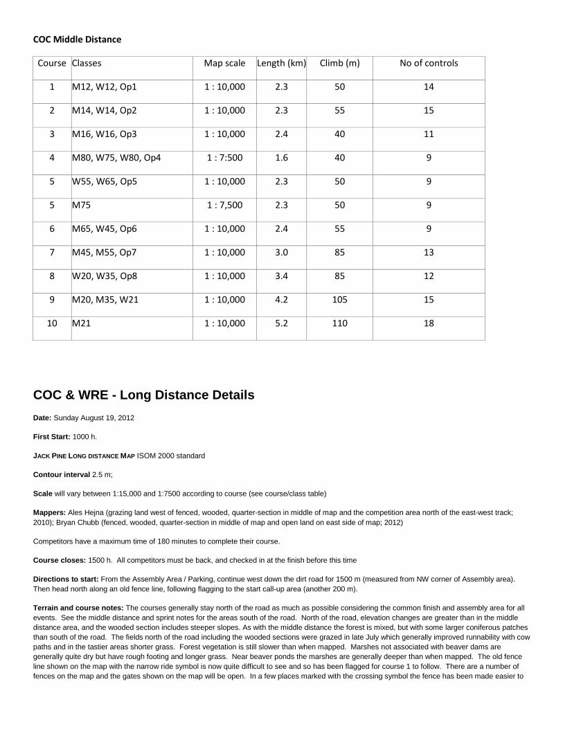
COC Middle Distance
Course Classes Map scale Length (km) Climb (m) No of controls
1 M12, W12, Op1 1 : 10,000 2.3 50 14
2 M14, W14, Op2 1 : 10,000 2.3 55 15
3 M16, W16, Op3 1 : 10,000 2.4 40 11
4 M80, W75, W80, Op4 1 : 7:500 1.6 40 9
5 W55, W65, Op5 1 : 10,000 2.3 50 9
5 M75 1 : 7,500 2.3 50 9
6 M65, W45, Op6 1 : 10,000 2.4 55 9
7 M45, M55, Op7 1 : 10,000 3.0 85 13
8 W20, W35, Op8 1 : 10,000 3.4 85 12
9 M20, M35, W21 1 : 10,000 4.2 105 15
10 M21 1 : 10,000 5.2 110 18
COC & WRE - Long Distance Details Date: Sunday August 19, 2012
First Start: 1000 h.
JACK PINE LONG DISTANCE MAP ISOM 2000 standard
Contour interval 2.5 m;
Scale will vary between 1:15,000 and 1:7500 according to course (see course/class table)
Mappers: Ales Hejna (grazing land west of fenced, wooded, quarter-section in middle of map and the competition area north of the east-west track; 2010); Bryan Chubb (fenced, wooded, quarter-section in middle of map and open land on east side of map; 2012)
Competitors have a maximum time of 180 minutes to complete their course.
Course closes: 1500 h. All competitors must be back, and checked in at the finish before this time
Directions to start: From the Assembly Area / Parking, continue west down the dirt road for 1500 m (measured from NW corner of Assembly area). Then head north along an old fence line, following flagging to the start call-up area (another 200 m).
Terrain and course notes: The courses generally stay north of the road as much as possible considering the common finish and assembly area for all events. See the middle distance and sprint notes for the areas south of the road. North of the road, elevation changes are greater than in the middle distance area, and the wooded section includes steeper slopes. As with the middle distance the forest is mixed, but with some larger coniferous patches than south of the road. The fields north of the road including the wooded sections were grazed in late July which generally improved runnability with cow paths and in the tastier areas shorter grass. Forest vegetation is still slower than when mapped. Marshes not associated with beaver dams are generally quite dry but have rough footing and longer grass. Near beaver ponds the marshes are generally deeper than when mapped. The old fence line shown on the map with the narrow ride symbol is now quite difficult to see and so has been flagged for course 1 to follow. There are a number of fences on the map and the gates shown on the map will be open. In a few places marked with the crossing symbol the fence has been made easier to
cross. If crossing fences at other locations PLEASE DO NOT CLIMB ON THE FENCE, rolling under is usually easier than going between the barbed wires.
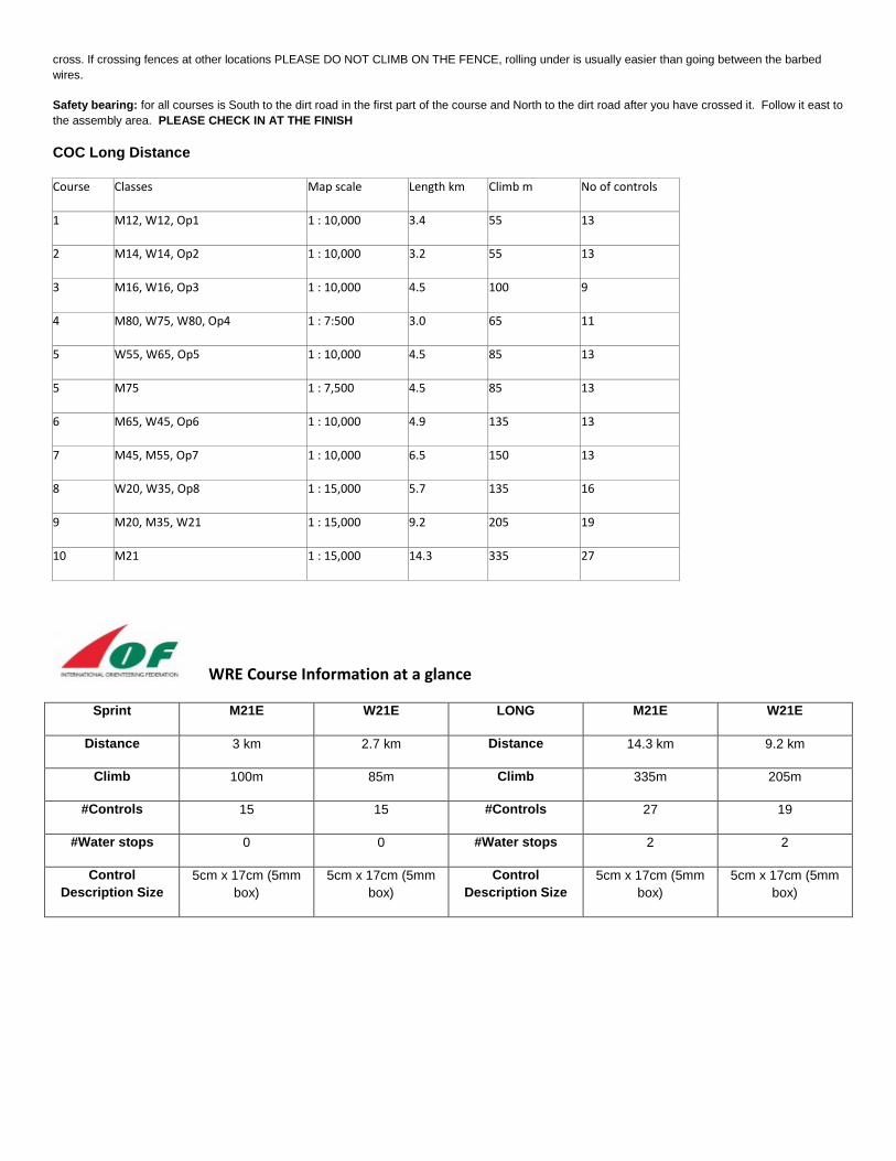
Safety bearing: for all courses is South to the dirt road in the first part of the course and North to the dirt road after you have crossed it. Follow it east to the assembly area. PLEASE CHECK IN AT THE FINISH
COC Long Distance
Course Classes Map scale Length km Climb m No of controls
1 M12, W12, Op1 1 : 10,000 3.4 55 13
2 M14, W14, Op2 1 : 10,000 3.2 55 13
3 M16, W16, Op3 1 : 10,000 4.5 100 9
4 M80, W75, W80, Op4 1 : 7:500 3.0 65 11
5 W55, W65, Op5 1 : 10,000 4.5 85 13
5 M75 1 : 7,500 4.5 85 13
6 M65, W45, Op6 1 : 10,000 4.9 135 13
7 M45, M55, Op7 1 : 10,000 6.5 150 13
8 W20, W35, Op8 1 : 15,000 5.7 135 16
9 M20, M35, W21 1 : 15,000 9.2 205 19
10 M21 1 : 15,000 14.3 335 27
WRE Course Information at a glance
Sprint M21E W21E LONG M21E W21E
Distance 3 km 2.7 km Distance 14.3 km 9.2 km
Climb 100m 85m Climb 335m 205m
#Controls 15 15 #Controls 27 19
#Water stops 0 0 #Water stops 2 2
Control Description Size
5cm x 17cm (5mm box)
5cm x 17cm (5mm box)
Control Description Size
5cm x 17cm (5mm box)
5cm x 17cm (5mm box)