Embed Size (px)
Citation preview

DWLBC REPORT
Padthaway Salt
Accession Study Volume
Four: Summary, Conclusions
and Recommendations
2005/35
Padthaway Salt Accession Study Volume Four: Summary, Conclusions and Recommendations
Nikki Harrington, Jason Van den Akker and Keith Brown
Knowledge and Information Division Department of Water, Land and Biodiversity Conservation
June 2006
Report DWLBC 2005/35
Knowledge and Information Division Department of Water, Land and Biodiversity Conservation 25 Grenfell Street, Adelaide GPO Box 2834, Adelaide SA 5001 Telephone National (08) 8463 6946 International +61 8 8463 6946 Fax National (08) 8463 6999 International +61 8 8463 6999 Website www.dwlbc.sa.gov.au Disclaimer Department of Water, Land and Biodiversity Conservation and its employees do not warrant or make any representation regarding the use, or results of the use, of the information contained herein as regards to its correctness, accuracy, reliability, currency or otherwise. The Department of Water, Land and Biodiversity Conservation and its employees expressly disclaims all liability or responsibility to any person using the information or advice. © Government of South Australia, through the Department of Water, Land and Biodiversity Conservation 2006 This work is Copyright. Apart from any use permitted under the Copyright Act 1968 (Cwlth), no part may be reproduced by any process without prior written permission obtained from the Department of Water, Land and Biodiversity Conservation. Requests and enquiries concerning reproduction and rights should be directed to the Chief Executive, Department of Water, Land and Biodiversity Conservation, GPO Box 2834, Adelaide SA 5001. ISBN 0-9775167-7-6 Preferred way to cite this publication Harrington, N, Van den Akker, J, and Brown, K 2006. Padthaway Salt Accession Study Volume Four: Summary, Conclusions and Recommendations, DWLBC Report 2005/35, Government of South Australia, through Department of Water, Land and Biodiversity Conservation, Adelaide.
Report DWLBC 2005/35 Padthaway Salt Accession Study Volume Four: Summary, Conclusions and Recommendations
i
FOREWORD
South Australia’s unique and precious natural resources are fundamental to the economic and social wellbeing of the State. It is critical that these resources are managed in a sustainable manner to safeguard them both for current users and for future generations.
The Department of Water, Land and Biodiversity Conservation (DWLBC) strives to ensure that our natural resources are managed so that they are available for all users, including the environment.
In order for us to best manage these natural resources it is imperative that we have a sound knowledge of their condition and how they are likely to respond to management changes. DWLBC scientific and technical staff continues to improve this knowledge through undertaking investigations, technical reviews and resource modelling.
Rob Freeman CHIEF EXECUTIVE DEPARTMENT OF WATER, LAND AND BIODIVERSITY CONSERVATION

Report DWLBC 2005/35 Padthaway Salt Accession Study Volume Four: Summary, Conclusions and Recommendations
ii

Report DWLBC 2005/35 Padthaway Salt Accession Study Volume Four: Summary, Conclusions and Recommendations
iii
CONTENTS
FOREWORD............................................................................................................................. i
1. INTRODUCTION.............................................................................................................1
2. THE PADTHAWAY SALT ACCESSION INVESTIGATION...........................................3
3. IMPACTS OF SALINE SOIL WATER FLUSHING IN THE NARACOORTE RANGES (OBJECTIVES 1 AND 3)................................................................................5
4. SOIL AND GROUNDWATER SALINISATION BELOW THE PADTHAWAY FLATS IRRIGATION DISTRICT (OBJECTIVES 2 AND 3)...............................................7
4.1 THE UNSATURATED ZONE SALT STORE ............................................................7 4.1.1 The Salt Store Beneath the Vines ................................................................................... 7 4.1.2 The Salt Store Beneath Centre Pivot Irrigation ............................................................... 8 4.1.3 The Salt Store Beneath Flood Irrigation .......................................................................... 8
4.2 SALINITY IMPACTS FROM DRIP IRRIGATED VINEYARDS .................................9 4.3 SALINITY IMPACTS FROM CENTRE PIVOT IRRIGATION....................................9 4.4 SALINITY IMPACTS FROM FLOOD IRRIGATION................................................10 4.5 GROUNDWATER SALINISATION FROM IRRIGATION ON THE PADTHAWAY
FLATS....................................................................................................................11
5. OUR NEW UNDERSTANDING OF GROUNDWATER SALINISATION PROCESSES IN THE PADTHAWAY PWA (OBJECTIVES 1, 2 AND 3) ....................13
5.1 WHAT WE KNOW ..................................................................................................13 5.2 WHAT WE DON’T YET KNOW ..............................................................................14
6. RECOMMENDATIONS FOR MANAGEMENT BASED ON THE CURRENT UNDERSTANDING OF GROUNDWATER SALINITY IN THE PADTHAWAY PWA..............................................................................................................................15
6.1 RECOMMENDATIONS FOR DETERMINATION OF THE PAV (OBJECTIVE 4)......................................................................................................15
6.2 POTENTIAL MANAGEMENT STRATEGIES (OBJECTIVE 5)..............................16 6.3 RECOMMENDATIONS FOR MONITORING (OBJECTIVE 6) ..............................17
7. ADDITIONAL WORK REQUIRED................................................................................19
APPENDICES........................................................................................................................21
UNITS OF MEASUREMENT .................................................................................................27
REFERENCES.......................................................................................................................29

Report DWLBC 2005/35 Padthaway Salt Accession Study Volume Four: Summary, Conclusions and Recommendations
iv
Report DWLBC 2005/35 Padthaway Salt Accession Study Volume Four: Summary, Conclusions and Recommendations
1
1. INTRODUCTION
The Padthaway area is a long established and important irrigation district in the South-East of South Australia, with vines, vegetables, various seed and pasture crops being the main irrigated produce. The total area irrigated is ~8700 ha, with the area currently planted with vines totalling ~3200 ha.
Groundwater for irrigation is sourced from a high yielding unconfined aquifer that occurs at shallow depth throughout the main irrigation area. Monitoring of groundwater quality has indicated an increase in average groundwater salinity by between 5–50 mg/L/yr over the past two decades.
This increase in groundwater salinity threatens the long term viability of some irrigation developments in parts of the Padthaway Prescribed Wells Area (PWA), particularly the established vineyards adjacent to the main Keith to Naracoorte road. Serious adverse impacts are already being experienced by some vignerons, and losses in production are expected if the increase in groundwater salinity is not arrested.

Report DWLBC 2005/35 Padthaway Salt Accession Study Volume Four: Summary, Conclusions and Recommendations
2

Report DWLBC 2005/35 Padthaway Salt Accession Study Volume Four: Summary, Conclusions and Recommendations
3
2. THE PADTHAWAY SALT ACCESSION INVESTIGATION
A key aspect in determining the sustainable level of groundwater use in this PWA is to quantify the magnitude of salt accession to the unconfined aquifer.
The following mechanisms have been believed to be responsible for salt accession to the watertable: • Pumping in excess of vertical recharge, combined with the cycling of the irrigation water,
resulting in the accession of the concentrated salt back to the unconfined aquifer.
• Mobilisation of the historic salt store in the unsaturated zone soil profile in the Naracoorte Ranges, adjacent the irrigation area. This was proposed to have occurred due to increased vertical recharge resulting from native vegetation clearance, and loss of high water use perennial pastures in the ranges in the east of the prescribed area.
The three-year objectives of the Padthaway Salt Accession Investigation and Determination of Sustainable Limits (PAV) study were therefore to: 1. Quantify the historic salt store contained within the soil profile, determine the recharge
rates, and determine the time lag associated with groundwater salinisation at selected sites.
2. Quantify groundwater extraction, irrigation application, crop water use, evaporation, and salt/water accession to the unconfined aquifer using different irrigation practices and the risk of groundwater salinisation at selected sites.
3. Undertake a qualitative risk assessment by the extrapolation of the site specific results obtained from (1) and (2), and determine the current salt and water budgets for the critical sub-areas of concentrated irrigation activity, and for the region as a whole.
4. Determine the sustainable extraction limit (PAV) for individual groundwater management areas that will result in sustainable resource management and arrest groundwater quality deterioration (and, where relevant, groundwater level decline) for the areas of concentrated irrigation activity, and the region as a whole, and revise management prescriptions.
5. Develop effective groundwater resource management strategies for the areas of concentrated irrigation activity, and the region as a whole, predict the response of the aquifer system to them, and implement these management strategies with community consultation.
6. Ensure the ongoing groundwater salinity monitoring program is effective and relevant.
The following is the last in a series of four reports on the Padthaway Salt Accession Investigation and Determination of Sustainable Limits (PAV) study. Volume 1 of the report series contains background information on the Padthaway Prescribed Wells Area (PWA), geology, hydrogeology and details of the project methodology. Volume 2 is a compilation and discussion of all field and analytical results. Volume 3 presents the interpretation of these results in terms of models of salt accession processes in the Naracoorte Ranges, salt

THE PADTHAWAY SALT ACCESSION INVESTIGATION
Report DWLBC 2005/35 Padthaway Salt Accession Study Volume Four: Summary, Conclusions and Recommendations
4
accessions below various irrigation practices on the Padthaway Flats, and the overall controls on groundwater salinity below the Padthaway Flats Irrigation area. This report provides a brief summary of the objectives, results and conclusions from the study and recommendations for effective groundwater management in the region based on this new understanding. Recommendations for further work to improve the confidence in the conceptual models developed to date are also made.
Report DWLBC 2005/35 Padthaway Salt Accession Study Volume Four: Summary, Conclusions and Recommendations
5
3. IMPACTS OF SALINE SOIL WATER FLUSHING IN THE NARACOORTE RANGES (OBJECTIVES 1 AND 3)
Salt accession to the water table in the Naracoorte Ranges, occurring as a result of increased drainage following clearing of native vegetation, was investigated using a one-dimensional model developed by Cook et al. (1989) and Cook et al. (2004). This model was originally developed for the Murray Basin and is based primarily on an empirical relationship observed between the drainage rate following land clearance and the amount of clay in the top two metres of the soil profile. The model parameters were adjusted to better reflect the rainfall and geology of the Padthaway area using (a) information collected from a series of soil cores, and (b) observed increases in groundwater level and salinity in observation wells in the Naracoorte Ranges. The one-dimensional model was extrapolated across the Naracoorte Ranges portion of the Padthaway Prescribed Wells Area by CSIRO Land and Water, using maps of clay content in the surface soils and depth to water table. From this, maps of salt flux to the water table at prescribed time intervals following clearing were created. The results of the modelling exercise showed that flushing of the unsaturated zone salt store over large parts of the Naracoorte Ranges portion of the PWA occurred in the 1970s and 1980s. Following flushing of this salt store, recharge of large amounts (up to 100 mm/y) of comparatively fresh water (~300 mg/L) occurs. This initial salinisation, followed by gradual freshening is supported by groundwater chemistry and 14C (of dissolved inorganic carbon) data.
The conclusions from this study on salt accession processes in the Naracoorte Ranges portion of the Padthaway PWA can be summarised as follows: • Clearing of native vegetation in the Naracoorte Ranges in approximately 1960, and
replacement of this with shallow rooted perennial crops has caused increased drainage through the unsaturated zone and flushing of pre-existing saline soil water into the groundwater system.
• Large amounts of the historical unsaturated zone salt store have already been flushed and this is the predominant mechanism contributing to rising groundwater salinities observed on the Padthaway Flats.
• Flushing of saline soil water is still occurring in parts of the Naracoorte Ranges and is likely to continue over approximately the next 5 to 10 years depending on the exact time that land clearance occurred. This time scale is a rough estimate only as the modelling that was carried out to reach these conclusions carries with it some limitations in its accuracy.
• The movement of this groundwater from the Naracoorte Ranges into the Padthaway Flats irrigation area is likely to have a positive effect on the groundwater resource there or at least mitigate any future salinity increases that are caused by the continued flushing of saline water in the Ranges or saline irrigation drainage on the Flats.

Report DWLBC 2005/35 Padthaway Salt Accession Study Volume Four: Summary, Conclusions and Recommendations
6
Report DWLBC 2005/35 Padthaway Salt Accession Study Volume Four: Summary, Conclusions and Recommendations
7
4. SOIL AND GROUNDWATER SALINISATION BELOW THE PADTHAWAY FLATS IRRIGATION DISTRICT (OBJECTIVES 2 AND 3)
The accession of salt to the water table from the recycling of irrigation water was measured at 7 irrigation sites (4 vineyards sites under dripper irrigation, 2 flood irrigation and 1 centre pivot site) as well as 2 background sites throughout the Padthaway irrigation district. To improve the confidence in the estimates of drainage and salinity impact, two independent approaches were used to compare drainage measured on a paddock and point scale. The methods used were: water balance (using both measured and theoretical soil water storage) and chloride mass balance.
The Commonwealth Scientific and Industrial Organisation (CSIRO) were engaged to measure spatially averaged crop water use at each of the vineyard sites. In addition, CSIRO installed four drainage meters at two vineyard sites to make direct measurement of drainage on a point scale.
Across most sites, there was general agreement in the estimates of drainage via the water balance and chloride mass balance methods, giving higher confidence in the estimates of drainage.
Monthly measurement of soil water salinity at depths of 1, 2 and 3 m in the unsaturated zone provided an insight to the solute transport processes occurring under different irrigation practices. An effective salinity of the drainage water was calculated, representing the net increase in salinity between the irrigation water and the drainage water due to evapotranspiration. This effective salinity was multiplied by the drainage term to determine the net salinity impact to the unconfined aquifer.
4.1 THE UNSATURATED ZONE SALT STORE The movement of salt through the unsaturated zone was investigated through the collection of pore water chloride vs depth profiles and measurement of soil water chloride and TDS (Total Dissolved Solids) in soil water samples collected from suction lysimeters. The chloride vs depth profiles provided a detailed “snapshot” of the soil salt store at one point in time, whilst the suction lysimeters allowed continued monitoring of any changes in this unsaturated zone salt store to be monitored. These methods allowed the following conclusions to be made about the unsaturated zone salt store below the main irrigation area at Padthaway:
4.1.1 THE SALT STORE BENEATH THE VINES • Large concentrations of salt have accumulated in soil water in the root zones beneath
the vines and inter-rows of the vineyards at Padthaway. Soil water TDS measured in suction lysimeters in the root zone below the vines range between approximately 4000 mg/L and greater than 8000 mg/L. The maximum chloride concentrations in the soil water chloride vs depth profiles below the inter-rows at the end of winter at two sites were 1500 mg/L and 2300 mg/L (TDS = 3300 mg/L and 5100 mg/L).
SOIL AND GROUNDWATER SALINISATION BELOW THE PADTHAWAY FLATS IRRIGATION DISTRICT (OBJECTIVES 2 AND 3)
Report DWLBC 2005/35 Padthaway Salt Accession Study Volume Four: Summary, Conclusions and Recommendations
8
• Based on the data collected to date from the suction lysimeters, there appears to be little change in the unsaturated zone salt store below the drip irrigated vineyards. This suggests that the high salinity soil water that has accumulated below the vineyards is not being flushed into the groundwater system on a seasonal basis. Discrepancies in the salt balance for these sites also suggest that this saline soil water does not move to the water table with the deep drainage that occurs each year.
• Instead, the results of this study to date suggest that water and solutes become decoupled from each other in the soil profile below the drip irrigated vineyards, with the following processes believed to occur:
○ Salt accumulation in the soil matrix during the irrigation season. This accumulation is eventually balanced by diffusion or slow mass flow through the soil matrix to the water table and a new steady state is reached.
○ Most drainage occurs in or towards the end of winter. However, this drainage moves through the soil via preferred pathways, dissolving and mobilizing salt that has accumulated within those pathways only. This drainage water does not interact with the majority of the salt store, which is controlled by accumulation and slow mass transport in the matrix.
4.1.2 THE SALT STORE BENEATH CENTRE PIVOT IRRIGATION • The average soil water salinity below the centre pivot site was two to three times greater
than the concentration of the irrigation water. Soil water salinity ranges from 3000 mg/L at a depth of 0.5 m to a maximum of 6000 mg/L at 2 m.
• Monthly measurements taken from depths of 0.5 m, 1 m and 2 m show seasonal fluctuations, with a steady increase in salt storage over the sampling period. Additional sampling is required to determine whether this represents an actual increase in salt storage over time.
• The greatest increase in soil water salinity was observed around the root zone, where it increased from 2300 mg/L in August 2004 to 3600 mg/L in June 2005. The total salt accumulation in the top 2 m of the soil profile was estimated to be ~6 t/ha.
• The observed changes in salt storage may be explained by an accumulation of salt through the irrigation season, followed by partial leaching during the period of deep drainage. However, further monitoring is required to confirm this.
4.1.3 THE SALT STORE BENEATH FLOOD IRRIGATION • The concentration of salts in soil water is reasonably constant with depth at both flood
irrigation sites, and is of a similar concentration to the irrigation water and underlying groundwater.
• Site NAP4 showed an increase in soil water salinity with increased distance from the sluice gate indicating that evapotranspiration significantly concentrated the irrigation water as it moved across the bay. At site NAP5, the effective salinity of drainage water across the bay is similar to that of the underlying groundwater and irrigation water, indicating minimal concentration of the irrigation water as it travels across the irrigation bay.
• The soil water salinity remained reasonably steady at depth over the sampling period, suggesting that there is no net accumulation or leaching of salt from the soil profile over time scales longer than one year.
SOIL AND GROUNDWATER SALINISATION BELOW THE PADTHAWAY FLATS IRRIGATION DISTRICT (OBJECTIVES 2 AND 3)
Report DWLBC 2005/35 Padthaway Salt Accession Study Volume Four: Summary, Conclusions and Recommendations
9
4.2 SALINITY IMPACTS FROM DRIP IRRIGATED VINEYARDS
The salt and water balances for the drip irrigated vineyards, interpreted in conjunction with the information on the unsaturated zone salt store described above, led to the following conclusions on the groundwater salinity impacts from drip irrigated vineyards at Padthaway: • Large concentrations of salt have accumulated in the root zone beneath the vineyards at
Padthaway. A new steady state appears to have been reached in the soil matrix between salt accumulation and loss to the water table. i.e. there is no seasonal flushing of salt from the soil zone into the unconfined aquifer, perhaps with the exception of salt accumulated within sediment-filled cracks and root channels.
• Based on the data collected to date, the net salinity impacts on the aquifer from drip irrigation range from 0 t/ha/y to 0.88 t/ha/y.
• This salinity impact is calculated as the effective increase in salinity of irrigation water as a result of evapotranspiration and the accession of this drainage water back to the groundwater system. The salinity impact occurs regardless of whether both the irrigation water pumped and the resulting drainage water are of lower salinities than the groundwater under which they are applied. This is due to the fact that extraction and evapotranspiration of the lower salinity groundwater resources reduces the benefit of this fresher water moving through the irrigation district.
• Groundwater chemistry data from below the vineyard sites suggests that the majority of the groundwater salinity currently observed here can be explained by salt accession processes occurring in the Naracoorte Ranges. However, due to a piezometer screen length of 6 m, small changes in groundwater chemistry near the water table as a result of mixing with irrigation drainage water would not be identified by this method.
• There was reasonably good agreement between different methods of calculating drainage for the vineyard sites. A limitation of the water balance methods is that these are currently based on a blanket application of CSIRO’s evaportanspiration measurements. These measurements may vary significantly between sites and hence these water balance calculations must be revised at completion of the CSIRO study in June 2006. The CSIRO study will also provide salt and water balance estimates for the drip irrigated vineyards based on highly accurate flux tower measurements and salinity impact estimates may need to be revised based on this.
4.3 SALINITY IMPACTS FROM CENTRE PIVOT IRRIGATION
The salt and water balances for the centre pivot irrigation site, interpreted in conjunction with the information on the unsaturated zone salt store from soil cores and suction lysimeters, led to the following conclusions on the groundwater salinity impacts from centre pivot irrigation at Padthaway: • Salt accumulation in the root zone has occurred over the study period. If this storage of
salt from irrigation continues, the net impact of centre pivot irrigation on the salinity of the aquifer is estimated to be approximately 0.9 to 1.4 t/ha/y.
• If this accumulation is followed by periods of flushing of salt back into the aquifer, the salinity impact on the aquifer would be much higher, approximately 6.2 to 7.1 t/ha/y.
SOIL AND GROUNDWATER SALINISATION BELOW THE PADTHAWAY FLATS IRRIGATION DISTRICT (OBJECTIVES 2 AND 3)
Report DWLBC 2005/35 Padthaway Salt Accession Study Volume Four: Summary, Conclusions and Recommendations
10
• Under both models, the equivalent salinity of the drainage water is higher than that of the underlying groundwater. This means that a direct salinity impact on the underlying groundwater from the irrigation drainage water is likely to be occurring.
• The chemical signature of the groundwater below the centre pivot suggests that the majority of salinity in the groundwater at the centre pivot site is currently derived from salt accession in the Naracoorte Ranges. However, due to a piezometer screen length of 6 m, small changes in groundwater chemistry near the water table as a result of mixing with irrigation drainage water would not be identified by this method.
• It is most unlikely that the currently observed salt build-up can continue indefinitely, and flushing of this salt into the groundwater system must occur at some time, or a new steady state must be reached, eventually resulting in a large salinity impact to the aquifer.
• There was a good agreement between the estimates of drainage via the chloride mass balance and water balance approaches.
• The results of this study indicate that longer term monitoring of soil and groundwater salinity below the centre pivot is required for an accurate quantification of the salinity impacts under this type of irrigation.
4.4 SALINITY IMPACTS FROM FLOOD IRRIGATION The salt and water balances for flood irrigation, interpreted in conjunction with the information on the unsaturated zone salt store from soil cores and suction lysimeters, led to the following conclusions on the groundwater salinity impacts from flood irrigation at Padthaway: • The salinity impact under flood irrigation is much higher than that for dripper and centre
pivot irrigation. This is due to the greater volumes of water that are used, although the actual change in salinity due to evapotranspiration is quite low here compared with the other irrigation types.
• The average net salinity impact on the aquifer at site NAP5 ranged between 1.6 t/ha/y and 2.2 t/ha/y, compared with NAP4, which showed a higher net impact on the aquifer, ranging between 4 t/ha/y and 6 t/ha/y.
• The difference between the two sites is believed to be related to soil thickness, width of irrigation bays, and different flow rates. All of these factors control the rate at which the irrigation water is applied and therefore the amount of surface water evaporation that occurs during irrigation. Site NAP5 has a narrower flood bay and a shallower top soil, compared to NAP4 which may contribute to quicker irrigation application and therefore a lower salinity impact on the aquifer.
• The groundwater chemistry data suggests that, as well as effects from salt accession in the Naracoorte Ranges, the groundwater salinity below the flood bay at both sites have been significantly affected by mixing with saline irrigation drainage water.
• Most of this mixing has occurred up-gradient of site NAP5, suggesting that there are large salinity impacts from irrigation occurring in this northern part of the Padthaway PWA.
• Evapotranspiration was calculated via the FAO56 methodology, which doesn’t account for surface evaporation during irrigation. There was a good agreement between drainage estimates using the water balance and chloride mass balance approach, however, it is considered that proper quantification of surface water evaporation of the water balance is necessary to improve our understanding of the salinity impacts from flood irrigation. Work to achieve this is currently being undertaken.
SOIL AND GROUNDWATER SALINISATION BELOW THE PADTHAWAY FLATS IRRIGATION DISTRICT (OBJECTIVES 2 AND 3)
Report DWLBC 2005/35 Padthaway Salt Accession Study Volume Four: Summary, Conclusions and Recommendations
11
4.5 GROUNDWATER SALINISATION FROM IRRIGATION ON THE PADTHAWAY FLATS
• To quantify the total salinity impact over the main irrigation area, the investigation site data was extrapolated to areas with similar crop type, soil type, irrigation practice and climate. While it is recognised that a degree of uncertainty is introduced in any spatial extrapolation of site specific data it was estimated that across the Padthaway Plains, 2344 ha of flood irrigation delivered the greatest salinity impact to the aquifer (~4600–13 000 tonnes annually). This was followed by 3214 ha of viticulture under drip irrigation, which contributed between 1143–2347 tonnes of salt, and 323 ha of centre pivot irrigation, which contributed between 290–445 tonnes annually of salt back to the aquifer.
SOIL AND GROUNDWATER SALINISATION BELOW THE PADTHAWAY FLATS IRRIGATION DISTRICT (OBJECTIVES 2 AND 3)
Report DWLBC 2005/35 Padthaway Salt Accession Study Volume Four: Summary, Conclusions and Recommendations
12
Report DWLBC 2005/35 Padthaway Salt Accession Study Volume Four: Summary, Conclusions and Recommendations
13
5. OUR NEW UNDERSTANDING OF GROUNDWATER SALINISATION PROCESSES IN THE PADTHAWAY PWA (OBJECTIVES 1, 2 AND 3)
5.1 WHAT WE KNOW • The majority of the groundwater salinity increase observed over the last 10–30 years in
the main irrigation area of the Padthaway PWA has been caused by the flushing of salts from the unsaturated zone in the Naracoorte Ranges. This has moved with the natural groundwater flow out onto the Padthaway Flats.
• Large quantities of saline soil water still remain in significant areas of the Naracoorte Ranges and this will continue to flush into the groundwater system over approximately the next decade, causing groundwater salinisation and having future salinity impacts in the main irrigation area.
• The unsaturated zone salt store in the Naracoorte Ranges is finite. In some parts of the Ranges, this has completely flushed and recharge of fresh (~300 mg/L) water is occurring at high rates (up to 100 mm/y) in these areas.
• The occurrence of fresh recharge in some parts of the Naracoorte Ranges will offset future salinity impacts to the main irrigation area caused by the continued flushing.
• The flux of salt from the Naracoorte Ranges through a 100 m wide cross section at Slumberdowns Rd is estimated to currently be around 35 t/yr. The peak salt flux of ~45 t/y probably occurred in the mid-1970s.
• Salinity impacts from drip irrigated vineyards are estimated to be 0–0.88 t/ha/y. This impact is estimated to be 0.9–1.4 t/ha/y from centre pivot and 1.6–6 t/ha/y from flood irrigation.
• In addition to this, bodies of saline soil water (up to 8000 mg/L) have built up in the unsaturated zone under drip and centre pivot irrigation on the Padthaway Flats.
• If these salt stores are relatively immobile and have reached a new steady state, the salinity impact of these irrigation practices is relatively small as mentioned above.
• However, if these salt stores become mobile, i.e. by flushing due to flooding or extremely heavy rainfall, the salinity impact of these irrigation practices would be much greater. This is particularly significant under centre pivot irrigation, where the salinity impact would be of the order of 6–7 t/ha/y if the apparently accumulating salt store became mobile.
• Due to the high volumes of water flushed through the soil each year under flood irrigation, the unsaturated zone salt store is at equilibrium with the irrigation drainage water under this irrigation practice, i.e. there is no accumulation or flushing of salt from the soil profile. However, due to the evapotranspiration of large volumes of irrigation water, the saliniity impact to the aquifer from flood irrigation is of the order of 1.6–6 t/ha/y.
OUR NEW UNDERSTANDING OF GROUNDWATER SALINISATION PROCESSES IN THE PADTHAWAY PWA (OBJECTIVES 1, 2 AND 3)
Report DWLBC 2005/35 Padthaway Salt Accession Study Volume Four: Summary, Conclusions and Recommendations
14
• The impact of saline irrigation drainage water on groundwater salinity is much more evident in the north of the PWA, possibly due to the greater occurrence of flood and centre pivot irrigation in that area, or the cumulative effect of all irrigation practices to the south.
5.2 WHAT WE DON’T YET KNOW • The impacts of any longer-term (greater than one year) processes of salt accumulation
or flushing in the unsaturated zone below the main irrigation area. Although greatly improving our understanding of groundwater salinity in the region, the current conclusions on salinity impacts from various irrigation practices on the Padthaway Flats are based on data from one or two irrigation seasons only. Observations over longer time scales are necessary to determine whether processes of periodic build up and flushing of salt from the soil should be considered in estimations of salinity impact.
• The effects of crop rotation on salinity impacts from flood and centre pivot irrigation on the Padthaway Flats.
• The effects of current groundwater extraction on movement of salty/fresh water through the main irrigation area. In particular, high levels of groundwater extraction along the main Keith – Naracoorte highway (the base of the Naracoorte Ranges) may be intercepting fresher water flowing from the Naracoorte Ranges into the main irrigation area. The effects of such interception and irrigation with this water are uncertain.
• The effects of recharge-reducing practices such as clay spreading and timber plantations on recharge and hence groundwater salinisation/freshening processes in the Naracoorte Ranges.
• The effects of the Kanawinka Fault on movement of groundwater from the Naracoorte Ranges into the main Padthaway Flats irrigation area. Comparison of results from the preliminary two-dimensional numerical model with observation well salinity records has suggested that the fault may increase the rate of groundwater flow, if it has any effect at all.
• The effects of climate change (decreasing rainfall and increasing evapotranspiration) on future groundwater salinities in the main Padthaway irrigation area.

Report DWLBC 2005/35 Padthaway Salt Accession Study Volume Four: Summary, Conclusions and Recommendations
15
6. RECOMMENDATIONS FOR MANAGEMENT BASED ON THE CURRENT UNDERSTANDING OF GROUNDWATER SALINITY IN THE PADTHAWAY PWA
6.1 RECOMMENDATIONS FOR DETERMINATION OF THE PAV (OBJECTIVE 4)
• Adjustment of the PAV to a revised TAR. Estimates of Total Available Recharge (TAR) have been revised as part of the current Permissible Annual Volume (PAV) review (Brown et al., 2005). Setting the PAV at the level of the TAR is intended to maintain through-flow in the aquifer. The results of the Salt Accession Project have identified through-flow as a critical component of the water balance in management of salinity in the main irrigation area. The implications for failing to maintain through-flow in the Padthaway PWA are considered to be serious. Additionally, the results of the study have shown that maintaining an adequate level of through-flow from the Naracoorte Ranges to the main irrigation area, and throughout the main irrigation area, should allow stabilisation or improvement of groundwater quality in the main irrigation area over time. Therefore, the PAV should at least be adjusted to the level of the TAR, and the Volume for Licensed Allocation (VLA) reduced so that total use is less than or equal to the TAR where necessary.
• Assessment of critical through-flow fluxes using 3-D groundwater flow and solute transport model. The critical through-flow flux required to achieve specified water quality targets should be assessed using the 3-D groundwater flow and solute transport model that is currently being constructed by DWLBC. This may result in a recommendation to further reduce the PAV, and hence the VLA, across all Management Areas.
• Merging Management Areas 1-3. The recent PAV review has shown that current groundwater licensed allocations continue to exceed the TAR in Management Areas 2 and 3 (Brown et al., 2005). In particular, the volume of licensed allocations in Management Area 2 has always greatly exceeded estimates of recharge for that area. The results of the Salt Accession Investigation suggest that the current division of Management Areas 1–3 has little scientific merit and that these management areas could be revised. Merging Management Areas 1 to 3 would bring the level of allocation closer to the TAR for that area and provide a more achievable target for the community. However, this should be done with the objective of encouraging the movement of groundwater extraction licences to optimise through-flow in the aquifer, if possible. A safeguard against increasing extraction near the eastern boundary of the present Management Area 2, where good quality groundwater can be accessed, should be in place. Although potentially cumbersome in practice, license transfer applications within the merged management area could then be assessed based on criteria that better match the objectives of maintaining / improving groundwater through-flow.
RECOMMENDATIONS FOR MANAGEMENT BASED ON THE CURRENT UNDERSTANDING OF GROUNDWATER SALINITY IN THE PADTHAWAY PWA
Report DWLBC 2005/35 Padthaway Salt Accession Study Volume Four: Summary, Conclusions and Recommendations
16
• Management area boundaries aligned with groundwater flow paths. As an alternative to the above suggestion, management area boundaries could be aligned with groundwater flow paths, with the PAV for each management area set based on the through-flow required to achieve salinity targets. This critical through-flow would be determined using the 3-D groundwater model described below.
• Credits for irrigation return flows. The results of this study, particularly from the flood irrigation sites, have shown that any allocation scheme allowing a credit for irrigation return flows must take into consideration the salinity impact from those return flows.
6.2 POTENTIAL MANAGEMENT STRATEGIES (OBJECTIVE 5)
• A model-based approach to management. The Padthaway Salt Accession Investigation has provided a well-founded conceptual model of the water and salt balance for the Padthaway PWA. Few regions have the benefit of such a detailed conceptual model and it is suggested that this be used as input for a numerical model upon which management decisions can be based. Additionally, the model (both conceptual and numerical) can be refined and updated as monitoring data continues to be collected and new information is obtained.
• Management scenarios to be investigated. Based on the results of the Salt Accession Investigation, the following management strategies are proposed for assessment using the 3-D model:
○ Protect throughflow from the Naracoorte Ranges: Based on the key processes identified, this is considered to be critical to the management of groundwater salinity in the main irrigation area. The critical through-flow from the Naracoorte Ranges should be determined using the numerical model. The effects of current groundwater extractions, as well as increasing and decreasing extraction from the eastern edge of Management Area 2 must be assessed. The effects of, and optimal area for, a groundwater protection zone at eastern edge of Management Area 2 could also be assessed.
○ Maintenance of recharge in the Naracoorte Ranges. The critical areas and rates of recharge in the Naracoorte Ranges to allow flushing of fresher water into the aquifer and to achieve specified groundwater salinity targets could be determined using the numerical model. This could provide guidelines for recharge–limiting practices such as clay spreading and planting of high water use crops such as timber and lucerne in the Naracoorte Ranges (Management Area 4).
○ Importation of fresher water. This option may be considered attractive to alleviate the problem of groundwater salinity in the worst affected areas, where the benefit of flushing of fresher water from the Naracoorte Ranges may not be seen for decades. The likely benefits of such a practice, as well as any detrimental effects on the groundwater system, can be assessed using the numerical model.
○ Extraction of saline groundwater from the main irrigation area. This option would be similar to the Salt Interception Schemes implemented along the River Murray. In this case, groundwater would be extracted from the worst affected areas and disposed of, allowing fresher groundwater to flow into these areas. A major problem with such an option is disposal of the brackish groundwater. Additionally, the volume that would need to be pumped to achieve the desired benefit may be prohibitive or cause negative impacts such as a cone of depression or inflow of saline groundwater from other areas. This can be investigated using the numerical model.
RECOMMENDATIONS FOR MANAGEMENT BASED ON THE CURRENT UNDERSTANDING OF GROUNDWATER SALINITY IN THE PADTHAWAY PWA
Report DWLBC 2005/35 Padthaway Salt Accession Study Volume Four: Summary, Conclusions and Recommendations
17
○ Methods for enhancing throughflow. The implications of engineering solutions to enhance the throughflow of better quality groundwater from the Naracoorte Ranges, such as a drain along the groundwater flow path or a groundwater pumping scheme to induce a greater hydraulic gradient, could be assessed using the 3-D model.
○ Climate change. The potential effects of climate change (decreasing recharge and increasing evapotranspiration) would need to be included in the assessment of the above management options.
• Resource condition triggers. Whilst it is considered that the salinity trigger of 10 mg/L/y is still appropriate for the Padthaway PWA, the resource condition triggers for the Padthaway Flats and Naracoorte Ranges areas of the PWA could be updated to reflect the results of the Salt Accession Investigation. For example,
○ Large changes in the unsaturated zone salt store below the irrigation area. Monitoring of soil water salinity at key irrigation sites over the long term should be carried out quarterly to half-yearly. Long-term build-up of salt in the unsaturated zone or sudden decreases in soil water salinity (indicating flushing) would trigger a review of the conceptual model and an assessment of irrigation practices.
○ Decrease in the hydraulic gradient through the irrigation area. Identification of a critical hydraulic gradient could be one way of assessing whether the desired through-flow is being achieved. Guidelines for use of this as a resource condition trigger could be developed through the numerical modelling exercise.
○ Lack of improvement of groundwater quality coming from the Naracoorte Ranges. The results of the Salt Accession Investigation suggest that groundwater quality improvements will be seen in the Naracoorte Ranges over the next 5–10 yrs and that this will eventually benefit groundwater quality under the main irrigation area. This freshening is a critical feature of the conceptual model and is already being observed in some observation wells in the Naracoorte Ranges and on the Padthaway Flats. However, modelling of natural systems carries with it a large number of uncertainties, and a targeted monitoring program should be carried out to ensure that this freshening phenomenon occurs as predicted. The modelling exercise could be used to set appropriate triggers for review of the conceptual model if necessary.
6.3 RECOMMENDATIONS FOR MONITORING (OBJECTIVE 6)
• Improved Monitoring in the Naracoorte Ranges. The results of the Salt Accession Investigation have highlighted the importance of the Naracoorte Ranges in controlling groundwater salinity below the main irrigation area on the Padthaway Flats. However, there are approximately 8 salinity observation wells located in the Naracoorte Ranges portion of the Padthaway PWA. Some of these wells are windmills and in many cases, the screened interval is unknown making interpretation of the data difficult. It is proposed that the salinity monitoring network in the Naracoorte Ranges be revised to include (a) some short-screened water table wells in areas where flushing is predicted to not yet be complete, and (b) strategically placed salinity monitoring wells with known screen intervals that can be used in calibration / validation of the numerical model.
• Process-based monitoring on the Padthaway Flats. The majority of salinity observation wells on the Padthaway Flats are screened across large intervals of the aquifer. It is important to maintain monitoring at a selection of these wells to observe groundwater salinity changes that occur as a result of processes occurring in the Naracoorte Ranges. However, changes in groundwater quality that occur as a result of mixing with irrigation drainage water at the water table can be difficult to resolve in wells with such large screened intervals. Hence, it is considered important that the current salinity monitoring
RECOMMENDATIONS FOR MANAGEMENT BASED ON THE CURRENT UNDERSTANDING OF GROUNDWATER SALINITY IN THE PADTHAWAY PWA
Report DWLBC 2005/35 Padthaway Salt Accession Study Volume Four: Summary, Conclusions and Recommendations
18
network be augmented with a series of short-screened water table piezometers, preferably adjacent existing observation wells and suction lysimeter nests. Investigating the feasibility of water quality profiling in wells with longer screened intervals forms part of the proposal for additional work (App. A).

Report DWLBC 2005/35 Padthaway Salt Accession Study Volume Four: Summary, Conclusions and Recommendations
19
7. ADDITIONAL WORK REQUIRED
A proposal for additional work suggested as a result of this study is included in this report as Appendix A.

Report DWLBC 2005/35 Padthaway Salt Accession Study Volume Four: Summary, Conclusions and Recommendations
20
Report DWLBC 2005/35 Padthaway Salt Accession Study Volume Four: Summary, Conclusions and Recommendations
21
APPENDICES
A. PROPOSAL FOR ON-GOING WORK ON THE PADTHAWAY SALT ACCESSION INVESTIGATION
BACKGROUND
Two principal mechanisms have been identified as the cause of increasing groundwater salinity in the unconfined aquifer beneath the main irrigation area. These are: • Lateral inflow from the Naracoorte Ranges. Salt that had previously accumulated under
native vegetation was held in the unsaturated zone above the water table. Land clearance in the 1950s–1960s would have increased recharge and mobilised this historic salt store, moving it vertically towards the water table. Once entering the groundwater system, this salt has the potential to cause increases in groundwater salinity downstream.
• Mixing with saline irrigation drainage water, which has been concentrated by evapotranspiration, in the main Padthaway Flats irrigation area.
The objectives of the present study were to determine the relative importance of these two processes to the salt budget of the Padthaway Prescribed Wells Area (PWA) and, based on this, make recommendations for sustainable management of the groundwater resource.
The results of the present study have shown that: • Flushing of the historic salt store from the Ranges is the predominant process
responsible for increasing groundwater salinity observed in the main Padthaway Flats irrigation area.
• There is still a significant amount of salt remaining in the unsaturated zone in the Ranges. This remaining salt store is either currently flushing into the groundwater system, or will do so within the next 100 yrs.
• In large portions of the Naracoorte Ranges, flushing of the historic salt store is complete and recharge of large volumes of low salinity water is currently occurring. This inflow of fresh water will mitigate salinity increases that are being caused by continued flushing in some areas. This “freshening” of groundwater is being observed in some observation wells in the Naracoorte Ranges.
• Large quantities of salt are accumulating in the unsaturated zone beneath the main irrigation area, particularly under drip and centre pivot irrigation. Although the current data shows that the salinity impact from this salt store and from irrigation drainage water is minor compared with salinity derived from the Ranges, the ultimate fate of this salt store is still of concern. Given the short time-scale of the present investigation, it has not been possible to satisfactorily determine the dynamics of the processes leading to the salt accumulation, and hence under what conditions this may eventually move into the aquifer.
APPENDICES
Report DWLBC 2005/35 Padthaway Salt Accession Study Volume Four: Summary, Conclusions and Recommendations
22
The present study has greatly increased our understanding of the major processes affecting groundwater salinity in the Padthaway PWA, and some general recommendations of how to best manage the groundwater resource can be made based on these results. However, to properly assess the likely impacts of various management scenarios with a high level of confidence, the following is still required: • A better understanding of the long-term impacts of irrigation on the Padthaway Flats.
Conclusions have been drawn based on data collected over one to two irrigation seasons. Continued monitoring is required to determine whether longer-term processes of salt accumulation and flushing need to be considered.
• A better understanding of how factors such as groundwater extraction on the Padthaway Flats and at the break of slope of the Naracoorte Ranges are influencing the movement of salt through the groundwater system.
• A robust tool that incorporates all the processes known to be influencing groundwater salinity in the Padthaway PWA and can be used to investigate the likely impacts of proposed management options.
For this reason, an additional program of work has been proposed for the Padthaway PWA. This proposal contains details of (a) work that has already been agreed upon and is currently being carried out, and (b) proposed additional work, for which additional funding is required. The latter work is presented below, and in the accompanying proposed project budget, as a series of work packages. Each package can be undertaken independently and will have a unique benefit to the level of understanding of the salt accession processes operating in the Padthaway PWA. Such a work program could form Phase 3 of the Padthaway Salt Accession Investigation.
OBJECTIVES
The objectives of a third phase of the Padthaway Salt Accession Investigation would be to: • Obtain an improved understanding of long-term processes influencing salt movement
and storage in the unsaturated zone below the main Padthaway Flats irrigation are. This would build on the results from Phases 1 and 2.
• Develop a robust three-dimensional numerical groundwater flow and solute transport model for the Padthaway Area that:
○ Incorporates an accurate representation of all processes believed to influence groundwater salinity.
○ Can be used to better predict the future effects on groundwater salinity of the salt accessions and fresh water flushing from the Ranges.
○ Can be used to assess impacts of future management options.
APPROACH
Continuation of Phase 1 and 2 Activities
It is important that monitoring of the unsaturated zone and groundwater system below the main irrigation area be continued in order to properly understand the longer-term (time scales greater than one year) processes that influence salt fluxes to the water table in that area. Current monitoring activities that have been found to be particularly useful are:
APPENDICES
Report DWLBC 2005/35 Padthaway Salt Accession Study Volume Four: Summary, Conclusions and Recommendations
23
• A1: Soil water and groundwater sampling on the Padthaway Flats. Sampling of soil water from suction lysimeters, and groundwater from piezometers, for EC and Cl is carried out monthly, providing a good indication of changes in soil water salinity throughout the year. This activity is currently funded to the end of October 2005 and it is recommended that it be continued at the same frequency through another irrigation season, and until the end of winter 2006. This would allow a longer time frame for observing salt accumulation, as well as flushing by winter rains. Beyond this, monitoring of both soil water and groundwater salinities on a quarterly or bi-annually basis could be recommended, with periodic review of the results in terms of the conceptual model (perhaps to coincide with reviews of the Water Allocation Plan).
• A2: Continued monitoring of water balance parameters through the Agrilink instrumentation network. Automated monitoring of groundwater extraction and irrigation application, groundwater levels and soil moisture (capacitance) through the Agrilink telemetry network is currently funded to June 2006. This will capture an additional irrigation season of data. It is proposed that the benefit of continuing access to the telemetry network beyond that date be reviewed in June 2006.
• A3: Continued collection of vineyard water balance data (CSIRO). This is currently funded through the contract with CSIRO to June 2006, when the final results of that study will be presented. It is proposed that continuation of this project be reviewed in conjunction with that final report and in discussion with CSIRO in terms of what continued data collection could add to our understanding of salt accession processes in the Padthaway PWA.
• A4: Continued neutron moisture meter monitoring at the vineyard sites. This activity is being funded through the contract with CSIRO to June 2006.
Additional Work Proposed as a Result of the Current Study • B: Three-Dimensional Groundwater Flow and Solute Transport Modelling. A simple two-
dimensional modelling exercise included in the present study has shown that the development of a three-dimensional groundwater flow and solute transport model for the area is both viable and necessary for the incorporation of all of the processes believed to affect salt transport through the Padthaway PWA. It is proposed that a three-dimensional flow and solute model be constructed to simulate water and salt fluxes to the aquifer from both the effects of land clearance in the Ranges and irrigation activity on the Plain. Once calibrated the model could be used to undertake scenario modelling such as assessing the benefits/impacts of the proposed desalinisation plant.
• C: Investigation of surface evaporation losses from flood irrigation using stable isotopes. During the present study, estimates of evapotranspiration at the two flood irrigation sites were calculated using the FAO56 methodology. The limitation of this methodology in calculating ET under flood irrigation is that it only accounts for crop water use, and not surface evaporation. Hence, actual ET is underestimated, leading to an overestimate in drainage and salt flux calculations made using the water balance approach. Despite approximate agreement between drainage estimated using the water balance approach and the independent chloride mass balance approach, it is considered that proper quantification of the surface water evaporation component of the water balance could improve our understanding of the salinity impacts from flood irrigation. Results from the present study indicate that the degree of evapotranspiration and overall net salinity impact to the aquifer from flood irrigation may be related to (a) soil type, (b) thickness of the top soil, (c) rate at which the water is applied, (d) number of bays irrigated at one time, (e) width/area of the flood bay, and (f) climatic conditions. All of these factors affect the rate that water moves across the bay and therefore the amount of surface water evaporation that occurs during irrigation. It is proposed to further develop our
APPENDICES
Report DWLBC 2005/35 Padthaway Salt Accession Study Volume Four: Summary, Conclusions and Recommendations
24
understanding of evapotranspiration by undertaking a sampling program during the 2005–06 irrigation season. This will involve the sampling of irrigation water, groundwater and soil water across both flood irrigation study sites to look at changes in isotopic signature during irrigation.
• Stable isotopes δ2H and δ18O are affected (enriched) during evaporation through the fractionation process, imposing changes on the isotopic composition of soil water. Transpiration by plants does not cause fractionation. By measuring the isotope abundance changes in irrigation water and soil water at various stages during irrigation delivery, it is possible to quantify the amount of irrigation water evaporated, exclusive of transpiration.
This study will provide: ○ A direct indication of evaporation losses during irrigation; ○ Increased accuracy in our estimates of salinity impact under flood irrigation; and ○ A new tool to monitor key parameters relevant to water use efficiency.
• D2: Detailed characterisation of the salt store below drip irrigated vineyards. The present study has identified that large quantities of salt have accumulated in the soil profile below drip-irrigated vineyards at Padthaway. The characteristics of this salt store vary considerably between the vine-row and inter-row and it is likely that even more spatial variability exists within the vineyards. Changes in the salt store in the vine row are currently being monitored using suction lysimeters, and detailed “snapshot” profiles of soil water salinity have to date been obtained from the inter-row only. Based on the results of the present study, it is recommended that additional soil water chloride profiles be obtained to investigate the vineyard scale variability in this salt store. It is also recommended that at least one set of suction lysimeters should be installed in the inter-row to observe changes in the salt store in this region.
• D2: Unsaturated zone dye tracer test in vineyards to investigate theory of non-uniform drainage processes. The objective of this exercise will be to investigate the flow (drainage) and transport (solute) patterns through the heterogeneous unsaturated zone. It will increase our understanding on the processes, which could only previously be inferred from the use of capacitance probes and suction lysimeters. A dye can be used as a vadose tracer, where by, it is applied to the soil surface. After percolation, a pit can be dug which will allow us to visualize the spatial distribution of the dye. The use of pre-established capacitance probes and suction lysimeters could assist with the interpretation.
• E1: Additional calibration of the one-dimensional model for salt accessions in the Naracoorte Ranges. The one-dimensional model of increased drainage, recharge and salt flushing as a result of land clearance in the Naracoorte Ranges is based on an empirical relationship observed in data from a range of sites in south-eastern Australia. This relationship has been modified for the rainfall and geology of the Padthaway PWA through qualitative comparison between the model results and (a) a series of soil profiles collected in the south of the PWA, and (b) observed salinity and water level increases in observation wells across the Naracoorte Ranges portion of the PWA. The model results were scaled up across the Naracoorte Ranges using the clay content of surface soils from soil landscape unit (SLU) maps estimated by the Soils and Land Information Group, DWLBC. The clay content of surface soils is known to be the main factor controlling increases in drainage. Although this approach is considered to give a good qualitative and semi-quantitative understanding of the connection between the salt accession processes in the Naracoorte Ranges and increases in groundwater salinity on the flats, it is recommended that additional soil profile data be collected for comparison with the model predictions to increase confidence in the results. The model results would be used to guide the sampling process and hence, this would include collection of additional

APPENDICES
Report DWLBC 2005/35 Padthaway Salt Accession Study Volume Four: Summary, Conclusions and Recommendations
25
data from sites where the salt store is predicted to have been completely flushed, partially flushed and where large amounts of salt are still believed to remain in the soil profile.
• E2: Groundwater quality vs depth profiles on the Padthaway Flats. Measurement of variations in groundwater quality with depth in the 6 m piezometer screens below the Padthaway Flats irrigation area is desirable. To date, very little salinity impact from irrigation drainage water has been identified in groundwater sampled from below the main irrigation area. Although this result is encouraging, the large sampling interval of these piezometers may mean that some increases in groundwater salinity at the water table have not been observed in bulk groundwater samples. Identification of these small salinity changes, particularly in the southern part of the main irrigation area, would allow more accurate quantification of the impact of irrigation drainage water on groundwater salinity.
• E3: Collection of water quality versus depth profiles. By lowering a multi-parameter probe down within the screened interval of a piezometer, and continuously logging parameters such as EC, pH, dissolved oxygen, redox potential and temperature, is a cheap and effective way of investigating this. The technique works well in boreholes that are open to the aquifer (e.g. well IRR1 on the Padthaway Flat), but can be limited in piezometers if vertical flow occurs within the annulus and causes mixing within the piezometer. The success of the technique can only be determined by interpretation of the first series of results. This exercise would initially be carried out near the end of the next irrigation season (March 2006) and, if found to be effective, again to coincide with movement of winter rains through the soil profile (July 2006). If found to be effective, this method of monitoring groundwater salinity impacts from irrigation drainage water could be recommended as a routine practice at Padthaway.
• E4: A tracer test on the Padthaway Flats to determine groundwater flow velocities. This is likely to take the form of a point dilution test on selected observation wells, with the details and scope yet to be developed.
OUTCOMES
The outcomes of the additional work described above would be: • Increased confidence in the connection between salt accession processes occurring in
the Naracoorte Ranges and observed increases in groundwater salinity on the Padthaway Flats.
• A better understanding of the effects of current groundwater extractions on the migration of fresher recharge from the Naracoorte Ranges.
• A better understanding of long-term salt accumulation and flushing in the unsaturated zone below the main irrigation area.
• A robust numerical model that represents groundwater flow and solute transport processes in the Padthaway PWA and can be used to assess the future effects of various management scenarios.

APPENDICES
Report DWLBC 2005/35 Padthaway Salt Accession Study Volume Four: Summary, Conclusions and Recommendations
26
Report DWLBC 2005/35 Padthaway Salt Accession Study Volume Four: Summary, Conclusions and Recommendations
27
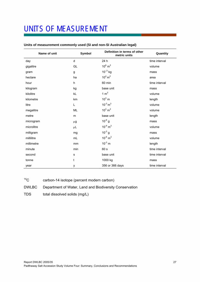
UNITS OF MEASUREMENT
Units of measurement commonly used (SI and non-SI Australian legal)
Name of unit Symbol Definition in terms of other metric units Quantity
day d 24 h time interval
gigalitre GL 106 m3 volume
gram g 10–3 kg mass
hectare ha 104 m2 area
hour h 60 min time interval
kilogram kg base unit mass
kilolitre kL 1 m3 volume
kilometre km 103 m length
litre L 10-3 m3 volume
megalitre ML 103 m3 volume
metre m base unit length
microgram μg 10-6 g mass
microlitre μL 10-9 m3 volume
milligram mg 10-3 g mass
millilitre mL 10-6 m3 volume
millimetre mm 10-3 m length
minute min 60 s time interval
second s base unit time interval
tonne t 1000 kg mass
year y 356 or 366 days time interval
14C carbon-14 isotope (percent modern carbon)
DWLBC Department of Water, Land and Biodiversity Conservation
TDS total dissolved solids (mg/L)

Report DWLBC 2005/35 Padthaway Salt Accession Study Volume Four: Summary, Conclusions and Recommendations
28
Report DWLBC 2005/35 Padthaway Salt Accession Study Volume Four: Summary, Conclusions and Recommendations
29
REFERENCES
Brown, K., Harrington, G. and Lawson, J., 2005, Review of Groundwater Resource Condition and Permissible Annual Volume for the South East Region of South Australia., Report DWLBC 2006/02.