Embed Size (px)
Citation preview
Padampur Airport
Orissa
Airports Authority of India
Airports Authority of India National Register of Airports / Airstrips – PADAMPUR
INDEX
Page No
1. About The City …………………………………………………………….1-2
2. Technical Details…………………………………………………………..3-7
3. Google Earth Pictures ……………………………………………........8
4. Site Photographs…………………………………………………………..9
5. Grid Map………………………………………………………………………10
6. Approach Rwy 11………………………………………………………….11
7. Approach Rwy 29………………………………………………………….12
8. 30 Km Obstruction Map…………………………………………………13
9. Inner Horizontal Surface Superimposed On Google Earth...14
Airports Authority of India National Register of Airports / Airstrips – PADAMPUR
1
ABOUT THE CITY AND AIRPORT CONNECTIVITY NAME OF THE AIRPORT (STATE) : PADAMPUR / SATIBHATA AIRSTRIP,ODISHA STATE (A) ABOUT THE CITY :
(I) INTRODUCTION : Padampur is also known as Padmapur. Padampur is a City in Padampur Tehsil in Bargarh District. It is located 81 Km towards west from District headquarters Bargarh. It is a Tehsil head quarter.
(II) ABOUT THE DISTRICT POPULATION, ECONOMY, INDUSTRY & TOURISM POTENTIAL :
POPULATION : According to 2011 census the population of Bargah district was 14,78,833. ECONOMY : Bargarh district is widely known as the rice bowl of India for its bumper rice production. There are some vegetables grown in the district i.e. Parwal, Cauliflower, Cabbage, Brinjal, Tomato, Mung, Biri etc. are widely supplied to other districts of Odisha. The food crops grown in the district mainly serves the domestic requirement of the Odisha people. The National market of rice is high support to the economy of Bargarh District. Bumper Paddy harvesting plays an important role in the economic scenario of Bargarh District. The irrigated blocks of Bargarh district i.e. Bargarh, Barpali,Attabira&Bheden are producing huge food (Paddy crop twice in a year) on behalf of Nation. INDUSTRY : Bargarh is one of the oldest industrial Handloom & Textile back bone of Odisha. Handloom and textile sector has a substantial role in shaping the economy of the District. Quality and Unique designed Cotton Sambalpuri handloom textile products have wide demand in the India and abroad, Textile cottage industries have important role towards the economy development of the District. There is a cement manufacturing unit located at Khaliapali which is at 6 Kmof distance from Bargarhdistrice headquarters, which is producing ACC Cement and marketing all over India. Bargarh district is also famous for its cottage Bell Metal Utensil industries. TOURISM POTENTIAL : There is a famous tourist place of Odisha, which is known as “NRUSHIHANNATH” in Paikmal block of Bargarh district having distance of 110 Km from Bargarh. It is a surrounded with forest of Gandhamardan Hill, rich with Ayurvedic Medicinal Plants & Herbal Plants. Tourist of this district added an extra Economical development of the district.
Airports Authority of India National Register of Airports / Airstrips – PADAMPUR
2
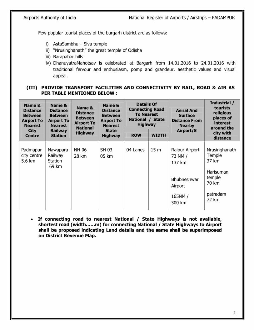
Few popular tourist places of the bargarh district are as follows:
i) AstaSambhu – Siva temple
ii) “Nrusinghanath” the great temple of Odisha
iii) Barapahar hills
iv) DhanuyatraMahotsav is celebrated at Bargarh from 14.01.2016 to 24.01.2016 with
traditional fervour and enthusiasm, pomp and grandeur, aesthetic values and visual
appeal.
(III) PROVIDE TRANSPORT FACILITIES AND CONNECTIVITY BY RAIL, ROAD & AIR AS
PER TABLE MENTIONED BELOW :
If connecting road to nearest National / State Highways is not available, shortest road (width……m) for connecting National / State Highways to Airport shall be proposed indicating Land details and the same shall be superimposed on District Revenue Map.
Name &
Distance Between
Airport To
Nearest City
Centre
Name &
Distance Between
Airport To
Nearest Railway
Station
Name & Distance
Between Airport To
National Highway
Name &
Distance Between
Airport To
Nearest State
Highway
Details Of
Connecting Road To Nearest
National / State Highway
Aerial And Surface
Distance From
Nearby Airport/S
Industrial /
tourists religious
places of interest
around the city with
distance ROW WIDTH
Padmapur city centre 5.6 km
Nawapara Railway Station 69 km
NH 06
28 km
SH 03
05 km
04 Lanes
15 m
Raipur Airport
73 NM /
137 km
Bhubneshwar
Airport
165NM /
300 km
Nrusinghanath Temple 37 km Harisuman temple 70 km patradam 72 km
Airports Authority of India National Register of Airports / Airstrips – PADAMPUR
3
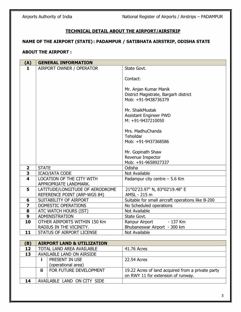
TECHNICAL DETAIL ABOUT THE AIRPORT/AIRSTRIP
NAME OF THE AIRPORT (STATE) : PADAMPUR / SATIBHATA AIRSTRIP, ODISHA STATE ABOUT THE AIRPORT :
(A) GENERAL INFORMATION
1 AIRPORT OWNER / OPERATOR State Govt. Contact: Mr. Anjan Kumar Manik District Magistrate, Bargarh district Mob: +91-9438736379 Mr. ShaikMustak Assistant Engineer PWD M: +91-9437210050 Mrs. MadhuChanda Tehsildar Mob: +91-9437368586 Mr. Gopinath Shaw Revenue Inspector Mob: +91-9658927337
2 STATE Odisha
3 ICAO/IATA CODE Not Available
4 LOCATION OF THE CITY WITH APPROPRIATE LANDMARK.
Padampur city centre – 5.6 Km
5 LATITUDE/LONGITUDE OF AERODROME REFERENCE POINT (ARP-WGS 84)
21°02'23.97" N, 83°02'19.48" E AMSL - 215 m
6 SUITABILITY OF AIRPORT Suitable for small aircraft operations like B-200
7 DOMESTIC OPERATIONS No Scheduled operations
8 ATC WATCH HOURS (IST) Not Available
9 ADMINISTRATION State Govt.
10 OTHER AIRPORTS WITHIN 150 Km RADIUS IN THE VICINITY.
Rairpur Airport - 137 Km Bhubaneswar Airport - 300 km
11 STATUS OF AIRPORT LICENSE Not Available
(B) AIRPORT LAND & UTILIZATION
12 TOTAL LAND AREA AVAILABLE 41.76 Acres
13 AVAILABLE LAND ON AIRSIDE
i PRESENT IN USE (operational area)
22.54 Acres
ii FOR FUTURE DEVELOPMENT 19.22 Acres of land acquired from a private party on RWY 11 for extension of runway.
14 AVAILABLE LAND ON CITY SIDE
Airports Authority of India National Register of Airports / Airstrips – PADAMPUR
4
i PRESENT IN USE Nil
ii FOR FUTURE DEVELOPMENT Nil
iii RESIDENTIAL AREA Nil
15 STATUS OF LAND (LEASE/LICENSE ETC.) State Govt. Owned
16 ADDL. LAND REQUIREMENT PROJECTED TO STATE GOVT.
i LAND COMMERICAL DEVELOPMENT Not Projected
ii LAND FOR SOLAR PANEL Not Earmarked
(C) TECHNICAL INFORMATION
AERODROME DATA(AIR SIDE)
17 AERODROME ELEVATION/ REFERENCE TEMPERATURE
215 m / 46° C
18 AERODROME REFERENCE CODE (ARC) 2 A
19 AERODROME TRAFFIC DENSITY State Govt. use only
20 TYPE OF TRAFFIC PERMITTED Small aircraft and helicopter operations only like Cessna, King Air B-200, Falcon 9x etc.
21 AERODROME RESCUE & FIRE FIGHTING CATEGORY (ARFF)
Not Available
22 ISOLATION BAY (DIMENSION) Not Available
23 WIND SOCK Not Available
(E) DECLARED DISTANCE (IN METER), if any
RWY TORA TODA ASDA LDA
33 RWY 11 915 m 915 m 915 m 915 m
34 RWY 29 915 m 915 m 915 m 915 m
(D) MOVEMENT AREA FACILITIES (AIR SIDE)
RUNWAYS
24 RUNWAY ORIENTATION 106°/286°
25 RUNWAY DESIGNATION /DIMENSION 11/29 915 m x 15 m
RWY SLOPE 1.2 %
26 DIMENSION OF RUNWAY STRIP 1035 m x 60 m
27 RUNWAYS STRENGTH (PCN) GSB – 200 mm WBM – 250 mm Pmc +Sdbc – 25 mm Total Thickness – 475 mm/19”
28 RUNWAY SHOULDERS 9.5 m on both sides
29 LOCATION OF THRESHOLD Available at the Beginning on both sides
30 STOPWAY/ BLAST PAD (SWY/BP) Not Available
31 TURN PADS Not Available
32 SIZE OF RESA ON BOTH ENDS OF RUNWAY
Available
Airports Authority of India National Register of Airports / Airstrips – PADAMPUR
5
(H) HANGARS WITH ASSOCIATED INFRASTRUCTURE
41 NON-AAI Nil
(I) AIRPORT GROUND LIGHTING SYSTEM
42 PROVIDE COMPLETE DETAIL OF LIGHTING SYSTEM AT THE AIRPORT
a RWY/ TWY/ TURNPAD/ APRON EDGE LIGHTS
Nil
b PRECISION APPROACH PATH INDICATOR (PAPI)
Nil
c APPROACH LIGHTING SYSTEM (ALS) Nil
d APRON FLOOD LIGHT Nil
e AERODROME BEACON Nil
f ISOLATION BAY LIGHTING Nil
g OBSTRUCTION LIGHT Nil
h LIGHTED LANDING ‘T’/ WDI Nil
i MARKINGS Nil
(J) COMMUNICATION, NAVIGATIONAL & SURVELLIANCE AIDS
43 PROVIDE COMPLETE DETAIL OF COMMUNICATION, NAVIGATIONAL & SURVEILLANCE OF THE AIRPORT
a AIR-TO- GROUND COMMUNICATION –VHF Nil
b GROUND-TO-GROUND COMMUNICATION HF /DVTRS/ HHRT/ MASTER CLOCK SYSTEM/ ATIS/DIAL-UP (AFTN) /DSCN/VPN/ AMSS/VCCS & LAN/WAN
Nil
c NDB/ DVOR/ DME (HIGH POWER) Nil
d ILS/DME (LOW POWER) (LLZ/GP) Nil
(F) TAXIWAYS
35 TWY DIMENSION / LOCATION Not Available
36 BEARING STRENGTH IN-PCN Not Applicable
37 SHOULDERS WIDTH(ASPHALT CONCRETE)
Not Applicable
(G) APRON
38 DIMENSION/AREA(IN SQ M) Not Available
39 CAPACITY Not Applicable
40 BEARING STRENGTH (PCN) Not Applicable
Airports Authority of India National Register of Airports / Airstrips – PADAMPUR
6
(K) AVIATION REFUELLING SERVICES FACILITY
44 CATEGORY Nil
45 EQUIPMENTS Nil
46 AGENCY PROVIDING FUEL Nil
(L) PASSENGER FACILITY INFORMATION
DOMESTIC SIDE INTERNATIONAL SIDE
47 TERMINAL BUILDING BUILT UP AREA (IN SQ M)
Not Available Nil
48 ANNUAL DESIGN CAPICTY (MPPA) Not Applicable Nil
49 PASSENGER FACILITATION
i (Provide details of all passengers Facilities)
Not Applicable Nil
(M) SECURITY AND SAFETY FACILITY
a PERIMETER BOUNDARY WALL/ FENCE (LENGTH/ HEIGHT IN M)
Brick wall of 1.8 m height with 0.9 m height grill over the wall. Length – 2700 m
b PERIMETER ROAD (LENGTH/ WIDTH) Not Available
c SECURITY GATES/ WATCH TOWER Available/Nil
d FIRE STATION/ MT WORKSHOP Not Available
(O) AIRPORT SERVICES
53 FIRE FIGHTING SYSTEM City Fire Service
54 WATER SUPPLY SYSTEM Not Available
55 RAIN WATER DISPOSAL SYSTEM Natural disposal
56 SEWAGE DISPOSAL SYSTEM No arrangement
57 SOLID WASTE MANAGEMENT SYSTEM No arrangement
58 POWER SUPPLY SYSTEM No Power Supply
59 ELECTRO MECHNICAL SYSTEM Not Available
60 APPROACH ROAD / EXIT ROAD Available, 51 m length and 3 m width
i DETAILS (INCLUDING FLYOVER,) UNDERPASSES ETC.)
Nil
(N) OTHER BUILDING INCLUDING MONUMENTS
50 OTHER BUILDINGS One rest room (4.25 m x 3.35 m = 14 sq. m) One Security guard room (2.5 m x 2.5 m = 6.25 sq. m)
51 RELIGIOUS MONUMENTS, IF ANY Nil
52 RESIDENTIAL BUILDING / AREA Nil
Airports Authority of India National Register of Airports / Airstrips – PADAMPUR
7
(P) ANNUAL TRAFFIC MOEMENT 2012-13 2013-14 2014-15
DOM INTL DOM INTL DOM INTL
61 AIRCRAFT MOVEMENT Nil Nil Nil Nil Nil Nil
62 PASSENGERS Nil Nil Nil Nil Nil Nil
63 CARGO (IN TONNES) Nil Nil Nil Nil Nil Nil
(Q)
MAJOR DEVELOPMENT WORKS STATUS
COST (Rs in Cr)
DOC
PDC
ADC
Nil Nil Nil Nil
WORKS COMPLETED DURING LAST THREE YEARS
64 ON-GOING WORKS Runway extension work in progress estimated cost 19.63 Cr (Land + Extension of runway)
65 PROPOSED WORKS Nil
(R) FUTURE DEVLOPMENT WORKS
66 CONDITIONS OF EXISTINGFACILITIES Good
67 OBSTRUCTION DETAILS No Obstruction
68 GENERAL CONDITIONS OF THE PAVED SURFACE AND OTHER INFRASTRUCTURES
Good
(S) SPECIFIC RECOMMENDATION ONSUITABILITY OF AIRPORT / AIRSTRIP
69 Airstrip is well maintained and suitable for small aircraft operations like B200.
Airports Authority of India National Register of Airports / Airstrips – PADAMPUR
8
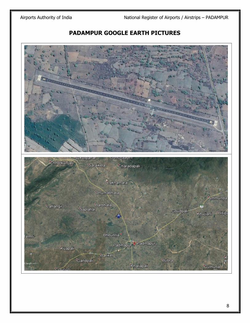
PADAMPUR GOOGLE EARTH PICTURES
Airports Authority of India National Register of Airports / Airstrips – PADAMPUR
9
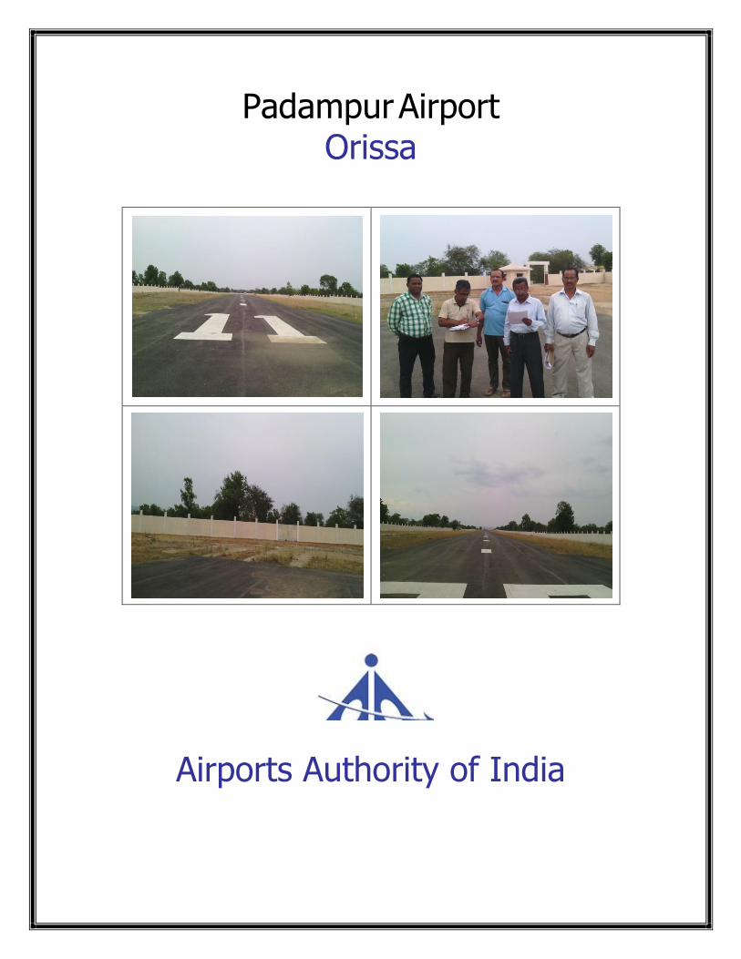
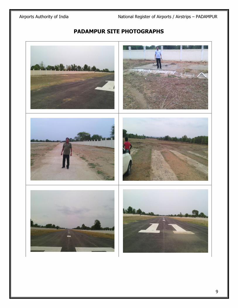
PADAMPUR SITE PHOTOGRAPHS
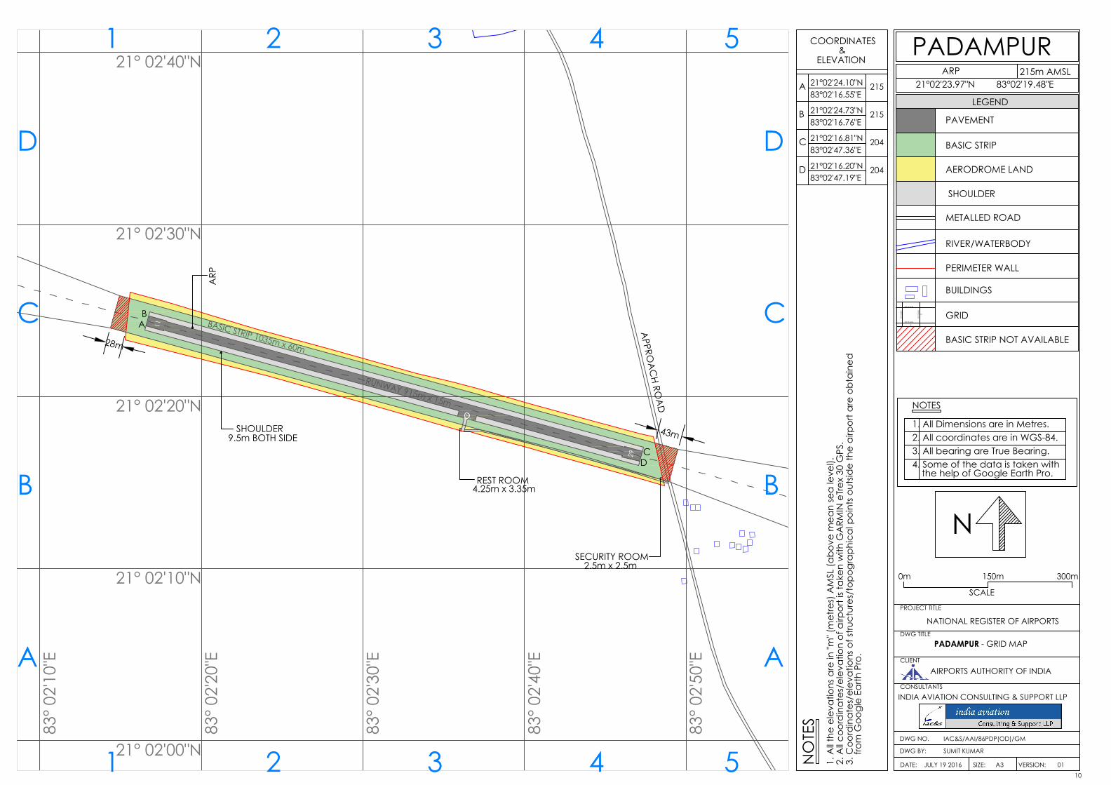
RUNWAY 915m x 15m
BASIC STRIP 1035m x 60m
H
11
29
21° 02'20"N
83°
02'
20"E
21° 02'30"N
83°
02'
30"E
21° 02'10"N
21° 02'00"N
83°
02'
10"E
83°
02'
40"E
83°
02'
50"E
21° 02'40"N215m AMSL
21°02'23.97"N 83°02'19.48"E
PROJECT TITLE
DWG TITLE
CLIENT
CONSULTANTS
DWG NO.
DWG BY:
DATE: SIZE: VERSION:
INDIA AVIATION CONSULTING & SUPPORT LLP
AIRPORTS AUTHORITY OF INDIA
PADAMPUR
LEGEND
IAC&S/AAI/86PDP(OD)/GM
SUMIT KUMAR
A3JULY 19 2016
NATIONAL REGISTER OF AIRPORTS
PADAMPUR - GRID MAP
PAVEMENT
BASIC STRIP
METALLED ROAD
RIVER/WATERBODY
PERIMETER WALL
BUILDINGS
GRID35°17'45"N
35°17'55"N
75°1
7'35
"E
75°1
7'45
"E
4
D
NOTES
1. All Dimensions are in Metres.2. All coordinates are in WGS-84.3. All bearing are True Bearing.
N
4. Some of the data is taken with the help of Google Earth Pro.
01
AERODROME LAND
BASIC STRIP NOT AVAILABLE
SCALE
0m
ARP
SHOULDER
A
B
C
D
COORDINATES&
ELEVATION
21521°02'24.10"N83°02'16.55"E
21521°02'24.73"N83°02'16.76"E
20421°02'16.81"N83°02'47.36"E
20421°02'16.20"N83°02'47.19"E
NO
TES
1. A
ll the
ele
vatio
ns a
re in
"m" (
met
res)
AM
SL (a
bove
mea
n se
a le
vel).
2.
All c
oord
inat
es/e
leva
tion
of a
irpor
t is t
aken
with
GA
RMIN
eTr
ex 3
0 G
PS.
3. C
oord
inat
es/e
leva
tions
of s
truct
ures
/top
ogra
phic
al p
oint
s out
side
the
airp
ort a
re o
btai
ned
from
Goo
gle
Earth
Pro
.A
B
C
D
1 2 3 4 5
A
B
C
D
1 2 3 4 5
ARP
APPRO
AC
H ROA
D
SHOULDER9.5m BOTH SIDE
AB
CD
REST ROOM4.25m x 3.35m
SECURITY ROOM2.5m x 2.5m
150m 300m
43m
28m
10
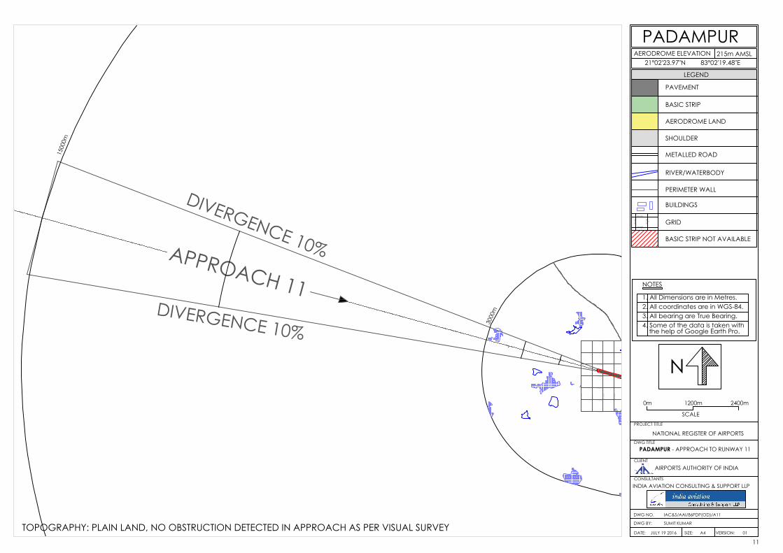
APPROACH 11
DIVERGENCE 10%
DIVERGENCE 10%
RUNWAY 915m x 15m
BASIC STRIP 1035m x 60m
H
11
3000
m
1500
0m
21° 02'20"N
83°
02'
20"E
21° 02'30"N
83°
02'
30"E
21° 02'10"N
21° 02'00"N
83°
02'
10"E
83°
02'
00"E
21° 02'40"N
21° 02'50"N
21° 01'50"N
215m AMSL21°02'23.97"N 83°02'19.48"E
PROJECT TITLE
DWG TITLE
CLIENT
CONSULTANTS
DWG NO.
DWG BY:
DATE: SIZE: VERSION:
INDIA AVIATION CONSULTING & SUPPORT LLP
AIRPORTS AUTHORITY OF INDIA
PADAMPUR
LEGEND
IAC&S/AAI/86PDP(OD)/A11
SUMIT KUMAR
A4JULY 19 2016
NATIONAL REGISTER OF AIRPORTS
PADAMPUR - APPROACH TO RUNWAY 11
PAVEMENT
BASIC STRIP
METALLED ROAD
RIVER/WATERBODY
PERIMETER WALL
BUILDINGS
GRID35°17'45"N
35°17'55"N
75°1
7'35
"E
75°1
7'45
"E
4
D
NOTES
1. All Dimensions are in Metres.2. All coordinates are in WGS-84.3. All bearing are True Bearing.
N
4. Some of the data is taken with the help of Google Earth Pro.
01
AERODROME LAND
BASIC STRIP NOT AVAILABLE
SCALE
0m
AERODROME ELEVATION
SHOULDER
1200m 2400m
TOPOGRAPHY: PLAIN LAND, NO OBSTRUCTION DETECTED IN APPROACH AS PER VISUAL SURVEY11
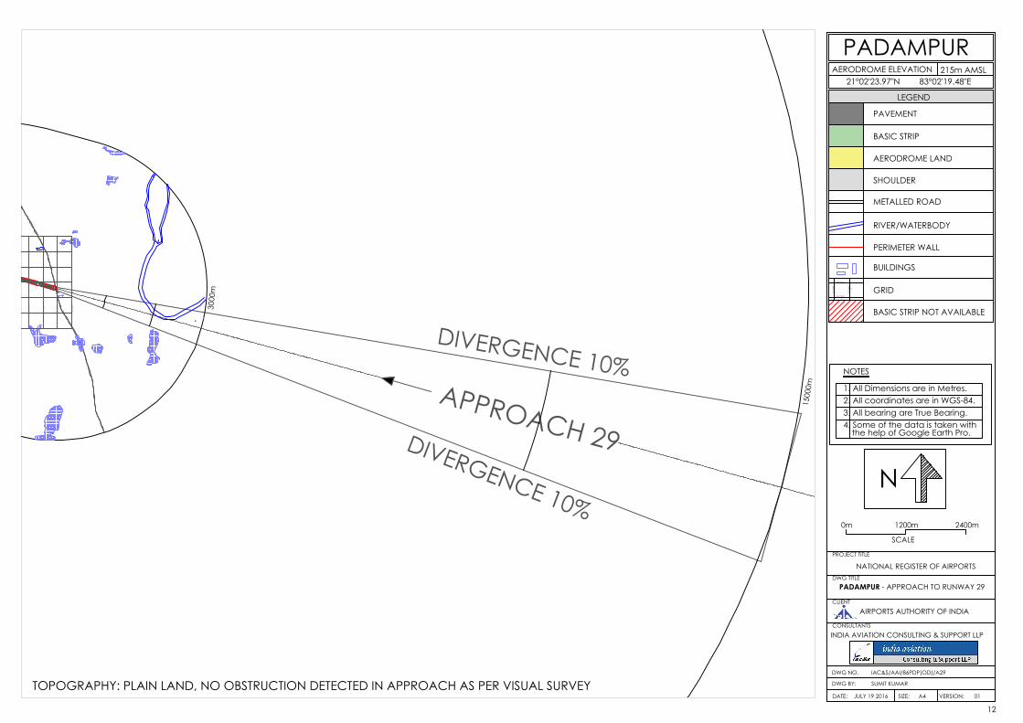
APPROACH 29
DIVERGENCE 10%
DIVERGENCE 10%
RUNWAY 915m x 15m
BASIC STRIP 1035m x 60m
H
29
3000
m
1500
0m
83°
02'
30"E
83°
02'
40"E
83°
02'
50"E
83°
03'
00"E
215m AMSL21°02'23.97"N 83°02'19.48"E
PROJECT TITLE
DWG TITLE
CLIENT
CONSULTANTS
DWG NO.
DWG BY:
DATE: SIZE: VERSION:
INDIA AVIATION CONSULTING & SUPPORT LLP
AIRPORTS AUTHORITY OF INDIA
PADAMPUR
LEGEND
IAC&S/AAI/86PDP(OD)/A29
SUMIT KUMAR
A4JULY 19 2016
NATIONAL REGISTER OF AIRPORTS
PADAMPUR - APPROACH TO RUNWAY 29
PAVEMENT
BASIC STRIP
METALLED ROAD
RIVER/WATERBODY
PERIMETER WALL
BUILDINGS
GRID35°17'45"N
35°17'55"N
75°1
7'35
"E
75°1
7'45
"E
4
D
NOTES
1. All Dimensions are in Metres.2. All coordinates are in WGS-84.3. All bearing are True Bearing.
N
4. Some of the data is taken with the help of Google Earth Pro.
01
AERODROME LAND
BASIC STRIP NOT AVAILABLE
AERODROME ELEVATION
SHOULDER
SCALE
0m 1200m 2400m
TOPOGRAPHY: PLAIN LAND, NO OBSTRUCTION DETECTED IN APPROACH AS PER VISUAL SURVEY
12
APPROACH 11
DIVERGENCE 10%
DIVERGENCE 10%
APPROACH 29
DIVERGENCE 10%
DIVERGENCE 10%
RUNWAY 915m x 15m
BASIC STRIP 1035m x 60m
H
11
29
3000
m
1500
0m
3000
m
1500
0m
21° 02'20"N
83°
02'
20"E
21° 02'30"N
83°
02'
30"E
21° 02'10"N
21° 02'00"N
83°
02'
10"E
83°
02'
00"E
83°
02'
40"E
83°
02'
50"E
83°
03'
00"E
21° 02'40"N
21° 02'50"N
21° 01'50"N
215m AMSL21°02'23.97"N 83°02'19.48"E
PROJECT TITLE
DWG TITLE
CLIENT
CONSULTANTS
DWG NO.
DWG BY:
DATE: SIZE: VERSION:
INDIA AVIATION CONSULTING & SUPPORT LLP
AIRPORTS AUTHORITY OF INDIA
PADAMPUR
LEGEND
IAC&S/AAI/86PDP(OD)/30KM
SUMIT KUMAR
A3JULY 19 2016
NATIONAL REGISTER OF AIRPORTS
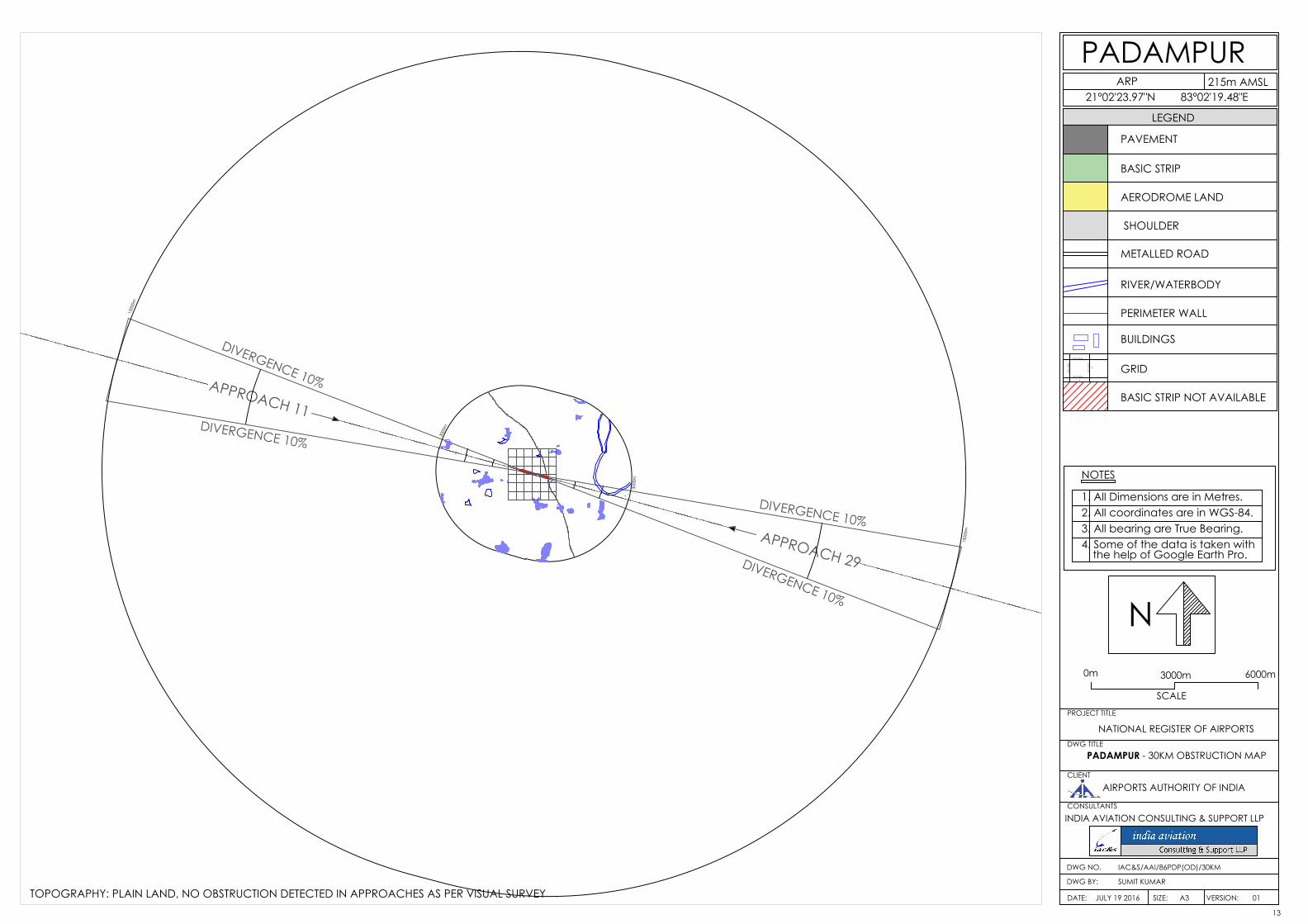
PADAMPUR - 30KM OBSTRUCTION MAP
PAVEMENT
BASIC STRIP
METALLED ROAD
RIVER/WATERBODY
PERIMETER WALL
BUILDINGS
GRID35°17'45"N
35°17'55"N
75°1
7'35
"E
75°1
7'45
"E
4
D
NOTES
1. All Dimensions are in Metres.2. All coordinates are in WGS-84.3. All bearing are True Bearing.
N
4. Some of the data is taken with the help of Google Earth Pro.
01
AERODROME LAND
BASIC STRIP NOT AVAILABLE
SCALE
0m 3000m 6000m
ARP
SHOULDER
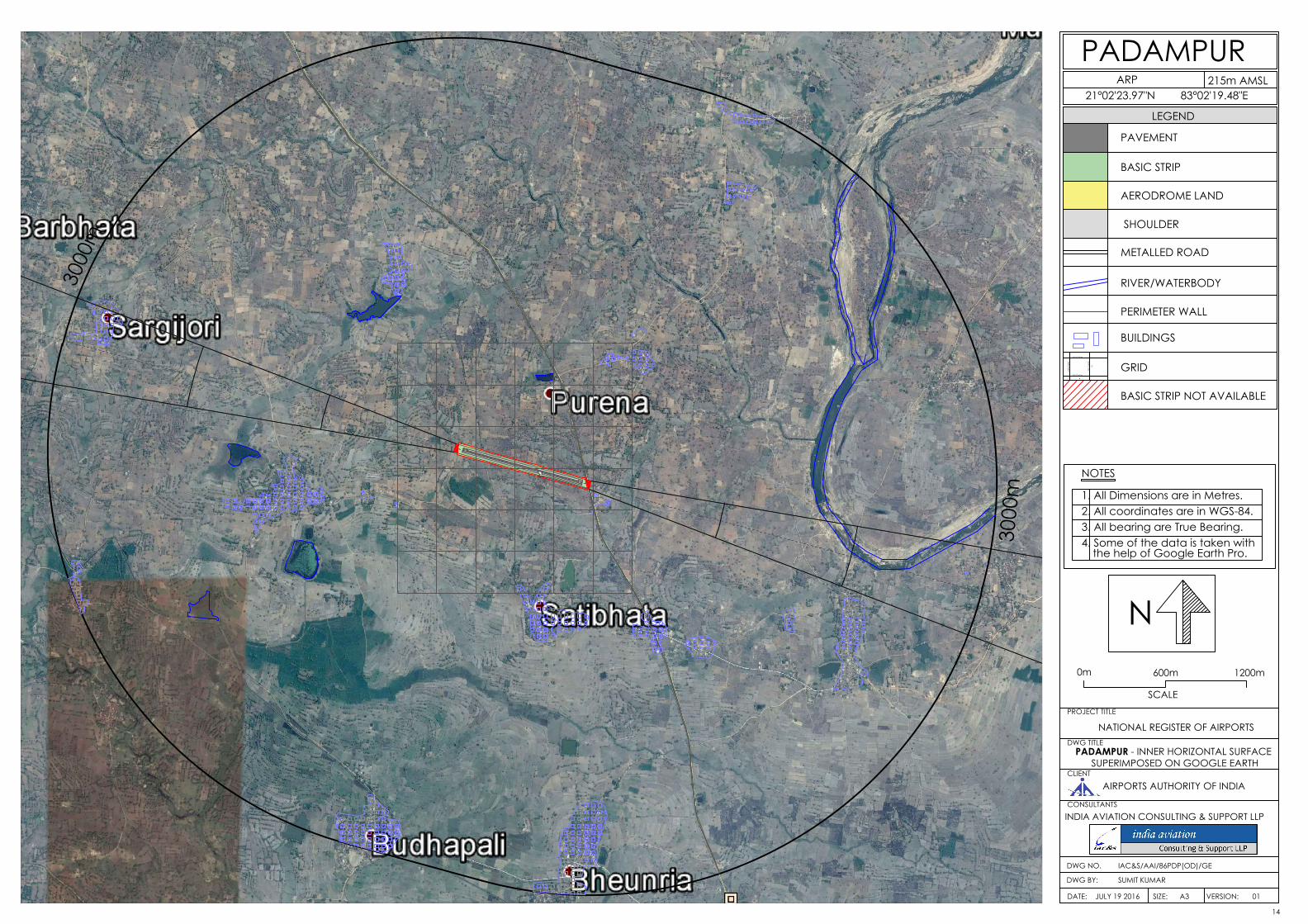
TOPOGRAPHY: PLAIN LAND, NO OBSTRUCTION DETECTED IN APPROACHES AS PER VISUAL SURVEY13
RUNWAY 915m x 15m
BASIC STRIP 1035m x 60m
H
11
29
3000
m
3000
m
21° 02'20"N 8
3° 0
2'20
"E
21° 02'30"N
83°
02'
30"E
21° 02'10"N
21° 02'00"N
83°
02'
10"E
83°
02'
00"E
83°
02'
40"E
83°
02'
50"E
83°
03'
00"E
21° 02'40"N
21° 02'50"N
21° 01'50"N
215m AMSL21°02'23.97"N 83°02'19.48"E
PROJECT TITLE
DWG TITLE
CLIENT
CONSULTANTS
DWG NO.
DWG BY:
DATE: SIZE: VERSION:
INDIA AVIATION CONSULTING & SUPPORT LLP
AIRPORTS AUTHORITY OF INDIA
PADAMPUR
LEGEND
IAC&S/AAI/86PDP(OD)/GE
SUMIT KUMAR
A3JULY 19 2016
NATIONAL REGISTER OF AIRPORTS
PADAMPUR - INNER HORIZONTAL SURFACE
PAVEMENT
BASIC STRIP
METALLED ROAD
RIVER/WATERBODY
PERIMETER WALL
BUILDINGS
GRID35°17'45"N
35°17'55"N
75°1
7'35
"E
75°1
7'45
"E
4
D
NOTES
1. All Dimensions are in Metres.2. All coordinates are in WGS-84.3. All bearing are True Bearing.
N
4. Some of the data is taken with the help of Google Earth Pro.
01
AERODROME LAND
BASIC STRIP NOT AVAILABLE
SCALE
0m 600m 1200m
ARP
SHOULDER
SUPERIMPOSED ON GOOGLE EARTH
14