Embed Size (px)
Citation preview

Update on the PACS Polarimeter Data Processing and Algorithm Development
J. Vanderlei Martins1,2, Roberto Fernandez-Borda2, Lorraine Remer1, Leroy Sparr2, Steven Buczkowski1,Leigh Munchak3, Frank
Harris1, Reed Espinosa1, Gergely Dolgos1, Oleg Dubovik4,1
1- UMBC 2- NASA GSFC 3- SSAI 4- Univ. Lille
LACO
https://ntrs.nasa.gov/search.jsp?R=20150023352 2018-05-01T04:55:23+00:00Z

ER2 – PACS VNIR+SWIR HARP
CubeSat Satellite
PACS SWIR
Incarnations of PACS:

An Inlet-Free Airborne Imaging Nephelometer (O-INEPH) for the Measurement of Atmospheric Particle’s Phase
Function
University of Maryland Baltimore County 3
Static Pylon
Housing the
Reflector
Scattered Laser Light
NASA P-3B
60 cm
Pressurized Pylon
Containing Laser,
Detection Optics and
Control System

PACS Data Analysis 1) L1 polarimeter data
a. Analyses and comparisons with L1 data • Radiance comparisons with AMS and MODIS
• Geo-location comparisons with AMS
• Multi-angle geo-registration
b. Analyses and comparisons to be done with L1 data in 2014 • Radiance and multi-angle polarization comparisons with AirMSPI and RSP
c. Availability: - LACO server at UMBC (June 2014); Transfer to Langley DAAC
(TBD/2014)
• Level 1B data in HDF5, Quick look images, Hyperangular movies
Example of hyperangular observations of sunglint from PACS-Aircraft
DoLP - Red Intensity RGB 10/16/2013 HARP - Systems Requirement Review -
UMBC proprietary

Multiple Viewing Angles (>100 angles)

Hyperangular Movie of Cloubow from PACS-Aircraft
Intensity RGB DoLP - Green 10/16/2013
HARP - Systems Requirement Review - UMBC proprietary

Cloudbow Measurements Possible for highly variable Scenes
D
A
D and A
parameters allow for
measurements of cloud droplet
effective radius and variance

Data intecomparisons:
• Leigh Munchak did preliminary intercomparisons with AMS and MODIS
• Calibration issues have been addressed after first intercomparison attempt
• Final intercomparisons are pending final level 1B production, which is happening now
• Work with Knobelspiesse for intercomparions with RSP and AirMSPI
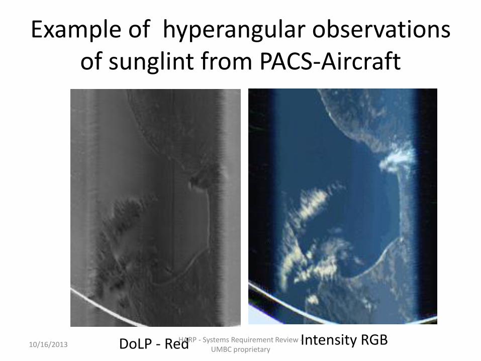
1
2 3 4
5
6
Preliminary AMS calibration Previous to our Revised Calibration Scheme

Preliminary Intercomparisons
PACS AMS
MODIS Aqua
MODIS Terra

Preliminary Radiance comparisons with AMS
• No spectral corrections
• Prior to our calibration
re-work
• More comparisons to come after completing level 1B processing
• Add AirMSPI and RSP

PACS Data Analysis 1) L1 polarimeter data
a. Analyses and comparisons with L1 data • Radiance comparisons with AMS and MODIS
• Geo-location comparisons with AMS
• Multi-angle geo-registration
b. Analyses and comparisons to be done with L1 data in 2014 • Radiance and multi-angle polarization comparisons with AirMSPI and RSP
c. Availability: - LACO server at UMBC (June 2014); Transfer to Langley DAAC
(TBD/2014)
• Level 1B data in HDF5, Quick look images, Hyperangular movies
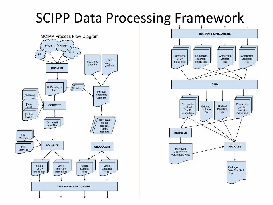
Process Flow Diagram
SCIPP Data Processing Framework

GRASP
Cloud Pro
SCIPP
HDF5
Gridded Geolocated/Calib
rated Level1B
GRASP
470nm
550nm
760nm
870nm
670nm
Lat.
Lon.
Geometry (viewing and solar)
PACS level 1B Data Production

GRASP
Cloud Pro
SCIPP
HDF5
Gridded Geolocated/Calib
rated Level1B
GRASP
440nm
550nm
870nm
670nm
Lat.
Lon.
Geometry (viewing and solar)
HARP level 1B Data Production

PACS Data Analysis
2) PACS L2 analysis activities
a. What analyses of L2 have been going on regarding – i. Aerosols
» Adaptation of the GRAPS algorithm for PACS retrievals
» Studies of aerosol retrievals above clouds
– ii. Clouds
» Retrievals of cloud droplet distributions
» Retrieval of cloud thermodynamic phase
b. Availability of L2 products • L2 products for aerosol and clouds to be produced and made available at the
UMBC server
– Cloud droplet effective radius and effective variance
– Cloud thermodynamic phase
– Cloud height
– Fine and coarse AOD
– Aerosol microphysics (size parameters fine and coarse modes, aerosol type)

PACS/HARP Level 2 Aerosol Algorithm
Cloud Pro
SCIIP
HDF5
Gridded Geolocated/Calib
rated Level1B
CloudPro:
Parametric retrievals:
• Cloud Height
• Droplet Effective radius and variance
• Cloud Phase

GRASP: Generalized Retrieval of Aerosol and Surface Properties
GRASP
lidar AERONET POLDER
AERONET
Surface BRDF, BPDF
shape
PACS/HARP

An Inlet-Free Airborne Imaging Nephelometer (O-INEPH) for the Measurement of Atmospheric Particle’s Phase
Function
University of Maryland Baltimore County 20
Static Pylon
Housing the
Reflector
Scattered Laser Light
NASA P-3B
60 cm
Pressurized Pylon
Containing Laser,
Detection Optics and
Control System

The UMBC polarized Imaging Nephelometer (PI-Neph) successfully measured phase matrix components P11 (phase function) and P12 leading to retrievals of size distributions, refractive
index, and sphericity fraction for a wide variety of aerosols at 3l (470, 532, 632nm).
Size distributions retrieved from P11 using Dubovik retrieval
J.V. Martins W.R. Espinosa
F.D. Orozco L.A. Remer
0 180100 15030 60−0.5
0
0.5
1
Scattering Angle
Linear Polarization (−P12/P11)
532 nm
0 30 60 90 120 150 180
10−1
100
101
102
saharan dust
Rim Fire smoke
biogenics
0 30 60 90 120 150 180
10−1
100
101
102
Scattering Angle
Normalized Phase Functions (P11)
532 nm
671 nm

GRASP: Generalized Retrieval of Aerosol and Surface Properties
GRASP
lidar AERONET POLDER
AERONET
Surface BRDF, BPDF
shape
PACS/HARP
PI-NEPH
single scattering

PACS Data Analysis b. Availability of L2 products
• L2 products for aerosol and clouds to be produced and made available at the UMBC server
– Cloud droplet effective radius and effective variance
– Cloud thermodynamic phase
– Cloud height
– Fine and coarse AOD
– Aerosol microphysics (size parameters on fine and coarse mode, aerosol type)
c. Use of DISCOVER-AQ data • PACS group has run the PI-Neph instrument during DICOVER-AQ/PODEX
and SEAC4RS. This data analysis is about to be completed and will be available for validation and aerosol microphysical characterization
• PI-Neph + LARGE data set for aerosol retrieval validation of the polarimeter retrievals

PACS Data Analysis
d. Use of other PODEX or related datasets for such analyses (e.g. CPL, AMS, etc.)
• PI-Neph + LARGE data set for aerosol retrieval validation of the polarimeter retrievals
• CPL will be used for cloud height validation
e. Future Plans for data analyses in 2014-2015 • Apply L2 algorithm to the whole PACS data set from PODEX
• PI-Neph data set will be used in conjunction with the LARGE aerosol data for validation of the polarimeter retrievals from the ER2 aircraft.

Thank you!!!
PACS