Embed Size (px)
Citation preview
Pacific Crest National Scenic Trail Corridor (PCT)
California Oregon
Washington
CA: Los Angeles County WA: Kittitas County
Congressional District CA 25: Howard P. "Buck" McKeon
WA 4: Doc Hastings
Location Pacific Crest National Scenic Trail in
California, Oregon and Washington along the Sierra and Cascade mountain ranges.
Acquired 2001-2011
Method Acres Cost ($) Purchase 11,422 $15,860,200 Purpose Secure permanent protection of the trail
corridor in order to preserve access and protect significant scenic, recreational, wildlife, and ecosystem resources. Eliminate prominent safety issues with rerouting existing highway road-walk.
Exchange 0 0 Donation 0 $20,000 Other
Partners Acquired parcels have been sold to federal ownership.
President’s Budget FY2012 Method Acres* Cost ($) Purchase Opportunities
Purchase in fee eight properties totaling 1,880 acres in California and Washington. The Trust for Public Lands has options on the Plum Creek Timberlands parcels. Santa Clarita is actively purchasing lands in Soledad Canyon. Multiple land owners have expressed willingness to sell.
Purchase 600 $2,939,500 Pending Future Action
Method Acres Cost ($) Pending 200,833 $144,685,300 *Approximate acreage, Includes fee and partial interest
Partners
Cooperators and Supporters
Trust for Public Lands and Riverside Land Conservancy/City of Santa Clarita
Trail-wide: Sixteen Members of Congress, including Reps. Inslee (WA), Waxman (CA), and DeFazio (OR), signed a support letter to fund the PCT land acquisition program in 2010. The Pacific Crest Trail Association, National Park Service, Bureau of Land Management, Sierra Club, The Nature Conservancy, Backcountry Horseman of America, American Hiking Society and the Wilderness Society. CA: Los Angeles County, Santa Monica Mountains Conservancy, Rivers and Mountains Conservancy, California Conservation Corps, and Pacific Forest Trust. WA: Alpine Lakes Protection Society, Audubon Society, Washington Trail Association, Conservation Northwest, and Northwest Service Academy (Americorps).
Project Description
Acquisition to protect and preserve the Pacific Crest National Scenic Trail corridor is authorized through the National Trails System Act (1968). A comprehensive inventory of parcels needed to secure protection of the PCT was completed in 2009 and identified 1,550 parcels. FY2012 proposed acquisitions are continuations of previous Forest Service projects to improve safety, access, and provide outstanding scenery for recreationists. In Washington, the acquisitions will complete a contiguous 177 miles of federally owned trail with high mountain lakes, stream, and rivers, large stands of old growth, and mountain meadows. In California, the acquisitions will provide a corridor for wildlife and recreationists that connects segments of the Angeles National Forest, and remove safety problems that currently exist with hikers and equestrians using the shoulder of the highway in Agua Dulce.
These projects protect open space and wildlife habitat by relieving development pressures, fragmentation and conversion by providing a continuous corridor and ecosystem resilience. Collectively, these parcels are critical for lessening the impacts of climate change by retaining water from rain events, providing urban heat island mitigation, capturing air pollution, and connecting habitats for future species migration due to warming temperatures. Acquisition will improve management efficiency and prevent issues common with development along Forest boundaries, such as restricted public land access, control of invasive species, and increased fire protection costs.
O&M Cost Strategic Goals
Start-up costs: $5,000 Estimated annual maintenance: $1,000
Goal 1. Healthy watersheds; Goal 2. Diverse habitats for threatened and endangered species; Goal 3. Conserve open space; Goal 4. Mitigation of climate change; Goal 5. Outstanding recreation use and public access; Goal 7. Management in congressional designated areas; Goal 8. Increased management efficiency.
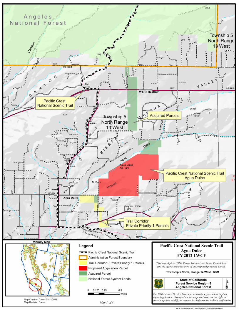
Pacific Crest National Scenic Trail (PCT) Acquisition Details 1. Agua Dulce – Angeles National Forest (Map 1 Parcels F, G, H, I) • 2012 Request: $1,000,000 to purchase 100 acres (total project). • History: Five parcels (111.6 acres) have been acquired for $3,767,000. • Future action: Four parcels totaling 18.8 acres remain to be acquired.
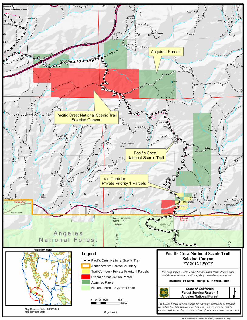
Values: Public safety is currently at risk in Agua Dulce, where PCT users must travel on the shoulder of a public highway for over five miles. Purchase of lands these parcels would significantly enhance the recreational experience, safety, and access of hikers and equestrians to the PCT and strengthen rural economies by providing tourism opportunities. This parcel would provide critical open space needed along this section of the PCT. The PCT location in Agua Dulce was listed in the Federal Register (1981) and is within the corridor of the congressionally designated Pacific Crest National Scenic Trail. This area is north of Soledad Canyon and the values have similar wildlife, watershed, and climate change mitigation values. 2. Soledad Canyon –Angeles National Forest and BLM, Palm Springs Field Office (Map 2) • 2012 Request: $2,400,000 to purchase 542 acres in fee (total project) o Young W. Song (K): $1,000,000 to purchase 24 acres o RDR Resolution (S): $800,000 to purchase 271 acres o Dan Jenkins et ux (X): $600,000 to purchase 147 acres
• History: Nine parcels (577.6 acres) have been acquired for $1,665,500. • Future action: Two parcels totaling 10 acres remain to be acquired.
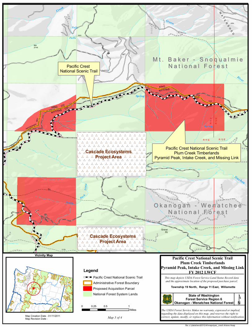
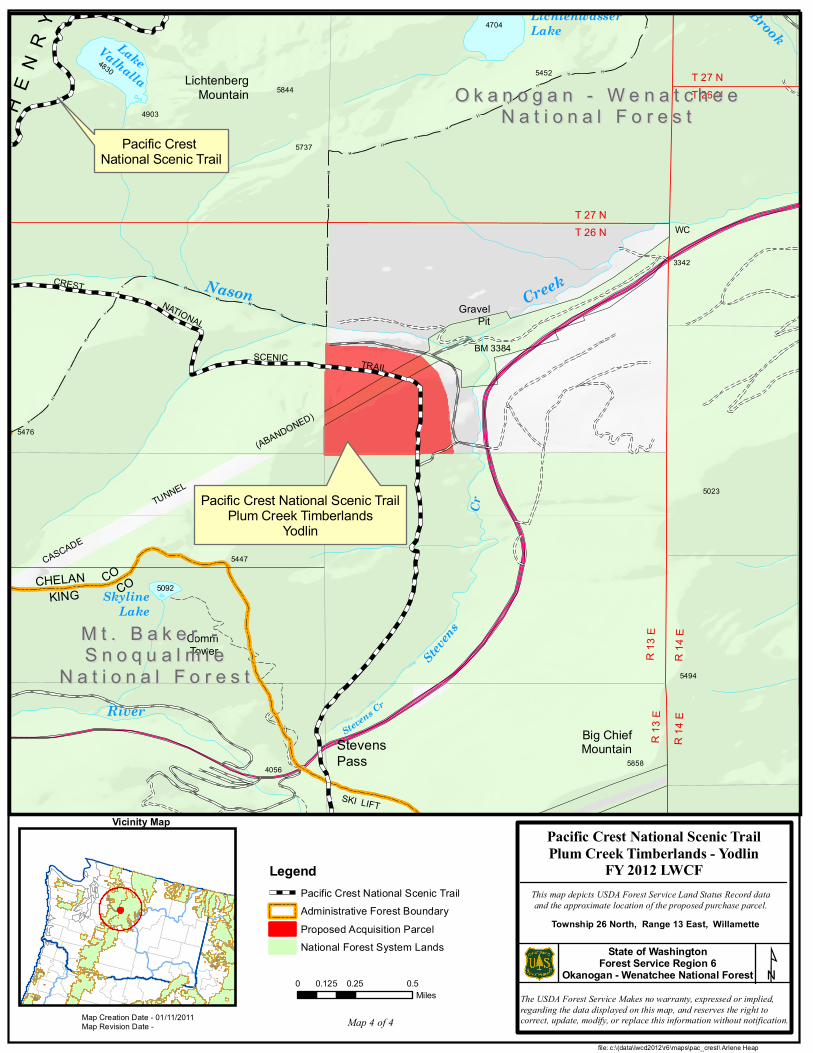
Values: Acquiring public lands in this region will enhance the health and continued viability in one of the last free-flowing natural riparian systems in southern California. An estimated seventeen threatened and/or endangered species can be found in the Santa Clara River watershed, including the California red-legged frog, arroyo toad, and least Bell’s vireo. This area has been identified as a high priority area for conservation. It is threatened by residential and industrial development. These parcels are in an area with significant gaps in connectivity of public lands. Linkage is a landscape level connection spanning a distance of 6-10 miles between two segments of the Angeles National Forest. Acquisitions provide an opportunity to link wildlife corridors and protect scenery resources, as well as, optimize opportunities for public recreation by protecting the PCT corridor for six miles. The PCT location in Soledad Canyon was listed in the Federal Register (1981) is within the corridor for the congressionally designated Pacific Crest National Scenic Trail. Consolidating the landownership pattern reduces the cost of boundary management, improves access, recreation opportunities, and the quality of the recreation experience. 3. Plum Creek Timberlands, Okanogan-Wenatchee National Forest in Washington (Maps 3 and 4) • 2012 Request: $3,000,000 to purchase 1338 acres in fee (total project), in four separate parcels.o Pyramid Peak(A): $750,000 to purchase 480 acres o Missing Link(B): $500,000 to purchase 168 acres o Intake Creek (C): $1,000,000 to purchase 640 acres o Yodlin (D): $750,000 to purchase acres
• History: 17 parcels have been acquired within the Washington Cascade ecosystem using LWCF funding and a $20,000 donation from the Trust for Public Lands.
• Future phase: There are several other parcels for future acquisitions in the Washington Cascades that would complete protection of the Pacific Crest Trail and/or corridor.
Values: These properties will aid water holding capacity for the upper watershed of the Yakima Basin and Wenatchee Valley. Acquisition provides connected intact habitat to Grey Wolf, Wolverine, Martin, Canadian Lynx, elk, deer, and moose between the southern and northern Cascades ecosystems. These parcels are critical acquisitions because of their proximity to Seattle and the unprecedented development pressures within the ecoregion. Acquisition would reduce fragmentation and conversion of undeveloped lands. Consolidation of the checkerboard landownership pattern will improve recreation opportunities, reduce the cost of boundary management, decrease road issues associated with developments inside the national forest, and reduce trespass problems. Ultimately, this consolidation improves access, the quality of the recreation experience, and builds resiliency into the ecosystem by creating intact connected landscapes.
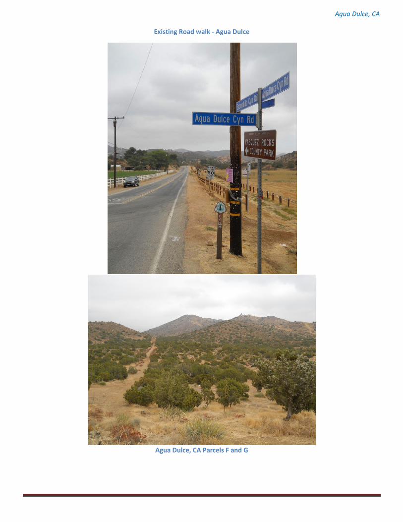
Agua Dulce, CA
Existing Road walk - Agua Dulce
Agua Dulce, CA Parcels F and G
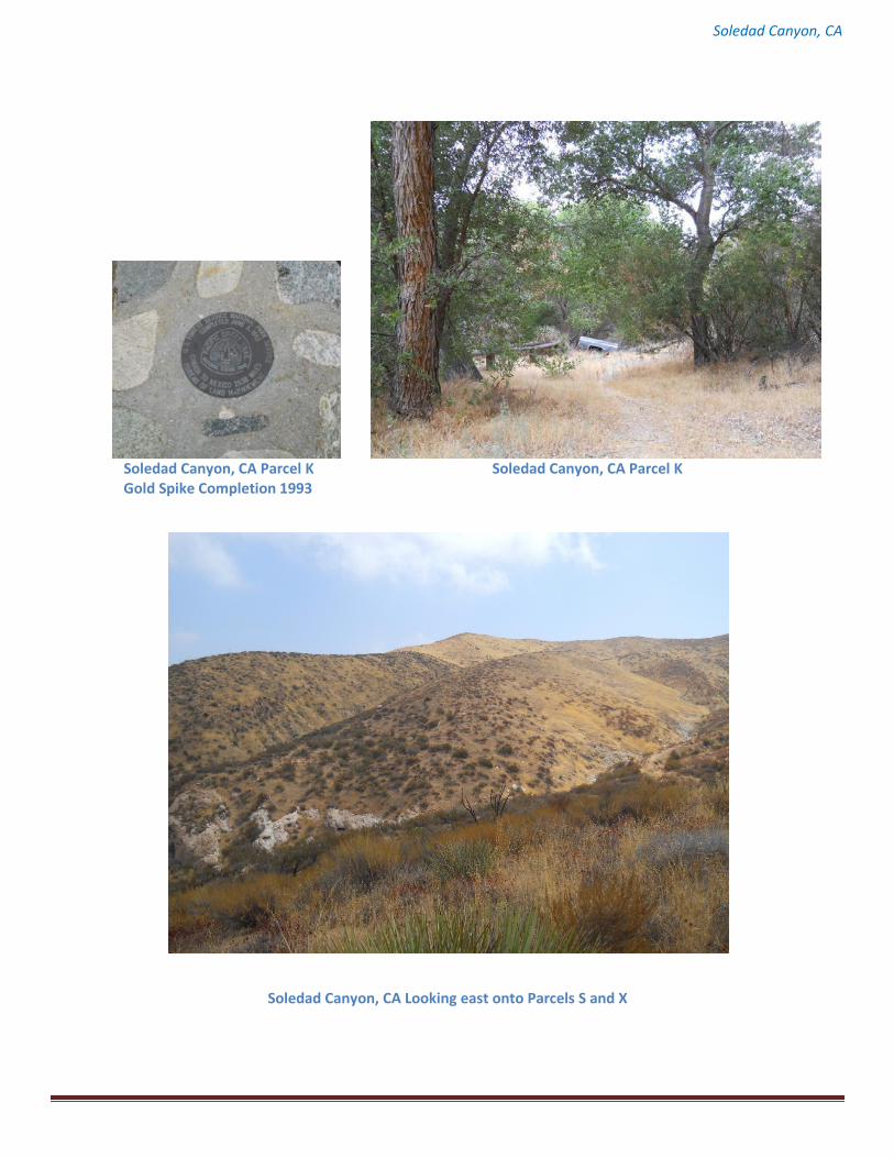
Soledad Canyon, CA
Soledad Canyon, CA Parcel K Soledad Canyon, CA Parcel K Gold Spike Completion 1993
Soledad Canyon, CA Looking east onto Parcels S and X
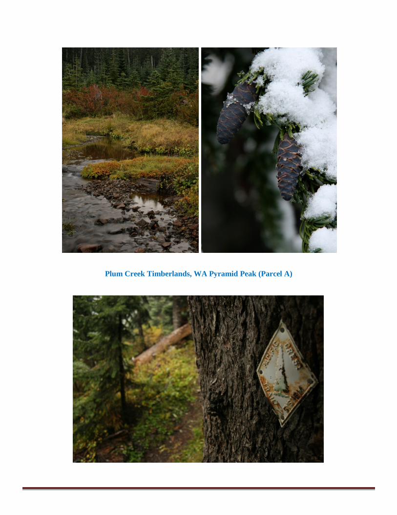
Plum Creek Timberlands, WA Pyramid Peak (Parcel A)
P e l o
n a
V a l l e y
D u l c
e
C a n y
o n
S i e r
r a
PIPELINE
ESCONDIDO
CANYON
FREE
WAY
A g u a
PCT
ST
PIPELINE
DARLING ROADAgua Dulce
2478
Air Park
Park
Vasquez
Mobile Home
Prospects
SaddlebackMountain
R 14 W R 13 W
Cany
on
Dulce
Agua
V A L L E Y
P E L O N AS I
E R R A
AGUA
DULCE
CANY
ON
RDHIGHWAY
C A N
Y O
N
Spring
Canyo
n
PACIF
IC
CRES
TNST
SCENIC
TRAIL
Agua DulceAir Park
2741
WT
3036
White Heather2797
Tunnel
Shaft
SIERRA
3853
2882
WT
2638
WT
Helipad
BM2755
R 13 WR 14 W
Township 5North Range
13 West
Township 5North Range
14 West
file: c:\(data\lwcd2012\r6\maps\pac_crest\ Arlene Heap
0 0.25 0.50.125Miles
State of CaliforniaForest Service Region 5Angeles National Forest
Map Creation Date - 01/11/2011Map Revision Date -
Pacific Crest National Scenic TrailAgua Dulce
FY 2012 LWCFThis map depicts USDA Forest Service Land Status Record dataand the approximate location of the proposed purchase parcel.
The USDA Forest Service Makes no warranty, expressed or implied,regarding the data displayed on this map, and reserves the right tocorrect, update, modify, or replace this information without notification.
Township 5 North, Range 14 West, SBM
LegendPacific Crest National Scenic TrailAdministrative Forest BoundaryTrail Corridor - Private Priority 1 ParcelsProposed Acquisition ParcelAcquired ParcelNational Forest System Lands
Vicinity Map
Pacific Crest National Scenic TrailAgua Dulce
Map 1 of 4
A n g e l e sA n g e l e sN a t i o n a l F o r e s tN a t i o n a l F o r e s t
Acquired Parcels
Trail Corridor Private Priority 1 Parcels
Pacific Crest National Scenic Trail
ESCONDIDO
M a r
g a r
i t a
HUBBARDROAD
S a n t a
FREE
WAY
PARK
E s c o n d i d o C a n y o n
ANTELOPE
VALLEY
C a n
y o n
C a n
y o nC a
n y o
n
S O L E D A D
C A N Y O N
L o n
g
N e l l
u s
B o b
c a t C a
n y o
nY o
u n g
C a n y o n
F r y e r
I n d i a n
C a n
y o n
C a n
y o n
ROCKS
2000
2000
PACIFIC
CRESTNATIONAL SCENIC
TRAIL
CREST
NATIONAL
PACIFIC
WT Water TankRuss
22122237
County DetentionCamp No 1
GoldenSpikeMonument
Helipad
Three SistersRock
BM2025 BM2162
BM2182
BM2243
BM2289
BM2060
SOLEDAD
SoledadCanyon
file: c:\(data\lwcd2012\r6\maps\pac_crest\ Arlene Heap
0 0.25 0.50.125Miles
State of CaliforniaForest Service Region 5Angeles National Forest
Map Creation Date - 01/11/2011Map Revision Date -
Pacific Crest National Scenic TrailSoledad CanyonFY 2012 LWCF
This map depicts USDA Forest Service Land Status Record dataand the approximate location of the proposed purchase parcel.
The USDA Forest Service Makes no warranty, expressed or implied,regarding the data displayed on this map, and reserves the right tocorrect, update, modify, or replace this information without notification.
Township 4/5 North, Range 13/14 West, SBM
LegendPacific Crest National Scenic TrailAdministrative Forest BoundaryTrail Corridor - Private Priority 1 ParcelsProposed Acquisition ParcelAcquired ParcelNational Forest System Lands
Vicinity Map
Pacific Crest National Scenic TrailSoledad Canyon
Map 2 of 4
A n g e l e sA n g e l e sN a t i o n a l F o r e s tN a t i o n a l F o r e s t
Acquired Parcels
Trail Corridor Private Priority 1 Parcels
Pacific Crest National Scenic Trail
941
Fork
Little
4752
North
GravelPit
941
Naches4907
KITTITAS
KING
KINGPIERCE
COCO
CO
1175
SCENIC
PACIFIC
NATIONAL
CREST
2000
PyramidPeak 5715
941
North
Littl
e
Fork
RiverKITTITA
S
COCO
KING
2000
GREEN RIVER WATERSHED(City Of Tacoma)
WindyGap
Nach
es
R 11
ER
12 E TRAIL
SCENIC
Spring
NATIONALSpringKITTITASKING
COCO
BDY
WATERSHED
WT
River
CreekGreen
N A T I O N A L
(CITY OF TACOMA)
"
WATERSHED
BDY
KINGKITTITAS COCO
PACI
FIC
CREST NAT
TRSCENIC
5290
Falls3005
BM2748
Falls
Creek
2000
5298
4284
CREST
R 12 ER 11 E
PACIFIC
W A T E R S H E D
file: c:\(data\lwcd2012\r6\maps\pac_crest\ Arlene Heap
0 0.5 10.25Miles
State of WashingtonForest Service Region 6
Okanogan - Wenatchee National Forest
Map Creation Date - 01/11/2011Map Revision Date -
Pacific Crest National Scenic TrailPlum Creek Timberlands
Pyramid Peak, Intake Creek, and Missing LinkFY 2012 LWCF
This map depicts USDA Forest Service Land Status Record dataand the approximate location of the proposed purchase parcel.
The USDA Forest Service Makes no warranty, expressed or implied,regarding the data displayed on this map, and reserves the right tocorrect, update, modify, or replace this information without notification.
Township 19 North, Range 11 East, Willamette
LegendPacific Crest National Scenic TrailAdministrative Forest BoundaryProposed Acquisition ParcelNational Forest System Lands
Vicinity Map
Pacific Crest National Scenic TrailPlum Creek Timberlands
Pyramid Peak, Intake Creek, and Missing Link
Map 3 of 4
O k a n o g a n - W e n a t c h e eO k a n o g a n - W e n a t c h e eN a t i o n a l F o r e s tN a t i o n a l F o r e s t
Pacific Crest National Scenic Trail
M t . B a k e r - S n o q u a l m i eM t . B a k e r - S n o q u a l m i eN a t i o n a l F o r e s tN a t i o n a l F o r e s t
Cascade EcosystemsProject Area
Cascade EcosystemsProject Area
R 14
ER
13 E
5858StevensPass
Stevens Cr
SKI LIFT
SKI L
IFTS
Grace Lakes
River
N A
T I
O N
A L
F O
R E
S T
4056
R 14
E
R 13
E
Stevens
Cr
SkylineLake
CommTower
5092
TUNNEL
CASCADE
CHELANKING
COCO
CRESTNATIONAL
TRAILSCENIC
(ABANDONED)
NasonGravel
PitCreek
BM 3384
T 26 NT 27 N
T 26 NT 27 N
WC
3342
LichtenwasserLake
MC
4704
LichtenbergMountain
LakeValhalla4830
BrookH
E N
R Y
5494
5447
5322
5550
4903
5737
58445452
5476
5023
Big ChiefMountain
file: c:\(data\lwcd2012\r6\maps\pac_crest\ Arlene Heap
0 0.25 0.50.125Miles
State of WashingtonForest Service Region 6
Okanogan - Wenatchee National Forest
Map Creation Date - 01/11/2011Map Revision Date -
Pacific Crest National Scenic TrailPlum Creek Timberlands - Yodlin
FY 2012 LWCFThis map depicts USDA Forest Service Land Status Record dataand the approximate location of the proposed purchase parcel.
The USDA Forest Service Makes no warranty, expressed or implied,regarding the data displayed on this map, and reserves the right tocorrect, update, modify, or replace this information without notification.
Township 26 North, Range 13 East, Willamette
LegendPacific Crest National Scenic TrailAdministrative Forest BoundaryProposed Acquisition ParcelNational Forest System Lands
Vicinity Map
Pacific Crest National Scenic TrailPlum Creek Timberlands
Yodlin
Map 4 of 4
O k a n o g a n - W e n a t c h e eO k a n o g a n - W e n a t c h e eN a t i o n a l F o r e s tN a t i o n a l F o r e s t
Pacific Crest National Scenic Trail
M t . B a k e r - M t . B a k e r - S n o q u a l m i eS n o q u a l m i e
N a t i o n a l F o r e s tN a t i o n a l F o r e s t