Embed Size (px)
Citation preview

PA Highlands Trail Network
Draft Feasibility Study Report

Pennsylvania Highlands Trail Network Feasibility Study Page 2
The Pennsylvania Highlands Trail Network (PHTN) Feasibility Study is being conducted under the direction of the Appalachian Mountain Club with guidance from the PHTN Steering Committee. The progress that has been achieved would not have been possible without the talent and vision of many partner organizations and individuals who generously contributed their time and expertise. The local knowledge shared by Steering Committee members, municipal representatives, and local/county/state park managers is invaluable to our efforts to establish the Pennsylvania Highlands Trail Network. For a complete list of project partners, visit: http://www.PAHighlandsTrail.org/
Support for the development of the Pennsylvania Highlands Trail Network has been generously provided by the Community Conservation Partnerships Program under the administration of the Pennsylvania Department of Conservation and Natural Resources (DCNR), Bureau of Recreation and Conservation; the William Penn Foundation; and the M. Edward Morris Foundation.

Pennsylvania Highlands Trail Network Feasibility Study Page 3
Acknowledgements ........................................................................... 2
Table of Contents ............................................................................... 3
Forward ................................................................................................ 3
About the Highlands .......................................................................... 5
Project Background ........................................................................... 6
PA Highlands Trail Network Feasibility Study Report ............ 9
Introduction ........................................................................................................................................................ 9
Trail Signage and Stewardship .................................................................................................................. 9
Trail Routes........................................................................................ 10
PHTN Segment #1 (Riegelsville to Quakertown) ..................................................... 11
Route Descriptions ....................................................................................................................................... 13
Northern Trunk Route Options ......................................................................................................... 21
Southern Trunk Route Options.......................................................................................................... 20
Spur Routes for Consideration................................................................................................................ 26

Pennsylvania Highlands Trail Network Feasibility Study Page 4
By John P. Brunner
A hundred years ago the average American walked on a regular basis, often out of necessity, but also because communities were still ‘walk-able’ and getting around on foot was the norm. In the car dependent culture of the 21st century, increasingly sedentary lifestyles and occupations have contributed to an epidemic of health problems. There has been a corresponding surge of interest in the development of trails to provide people with more opportunities to engage in healthy outdoor activities, and there’s a new emphasis on creating ‘livable communities’ where people can walk or bike to parks, stores, and schools. Recent studies have shown that by creating more desirable places to live, trails increase property values, stimulate job growth, and provide a boost to local businesses. In more populated areas, people use multi-use trails for commuting to work, to run daily errands, or simply to take a leisurely stroll with friends and family. In rural areas, people seek out secluded footpaths, bicycle routes and equestrian trails for a greater connection to the natural world. These are some of the many reasons why people all over the country are planning and building new trails - from footpaths at local parks and nature centers, to multi-use long-distance trails like the East Coast Greenway, and ‘large-landscape’ regional trails like the Pennsylvania Highlands Trail Network. This report lays out the vision for an interconnected network of trails in the Pennsylvania Highlands Region. Beyond the obvious benefits that will come with increased access to outdoor recreation, the Pennsylvania Highlands Trail Network will highlight the distinct natural and cultural history that distinguishes this region by creating connections between local, county, state and national parks and historic sites.
Pennsylvania Highlands Trail Network Feasibility Study Page 5
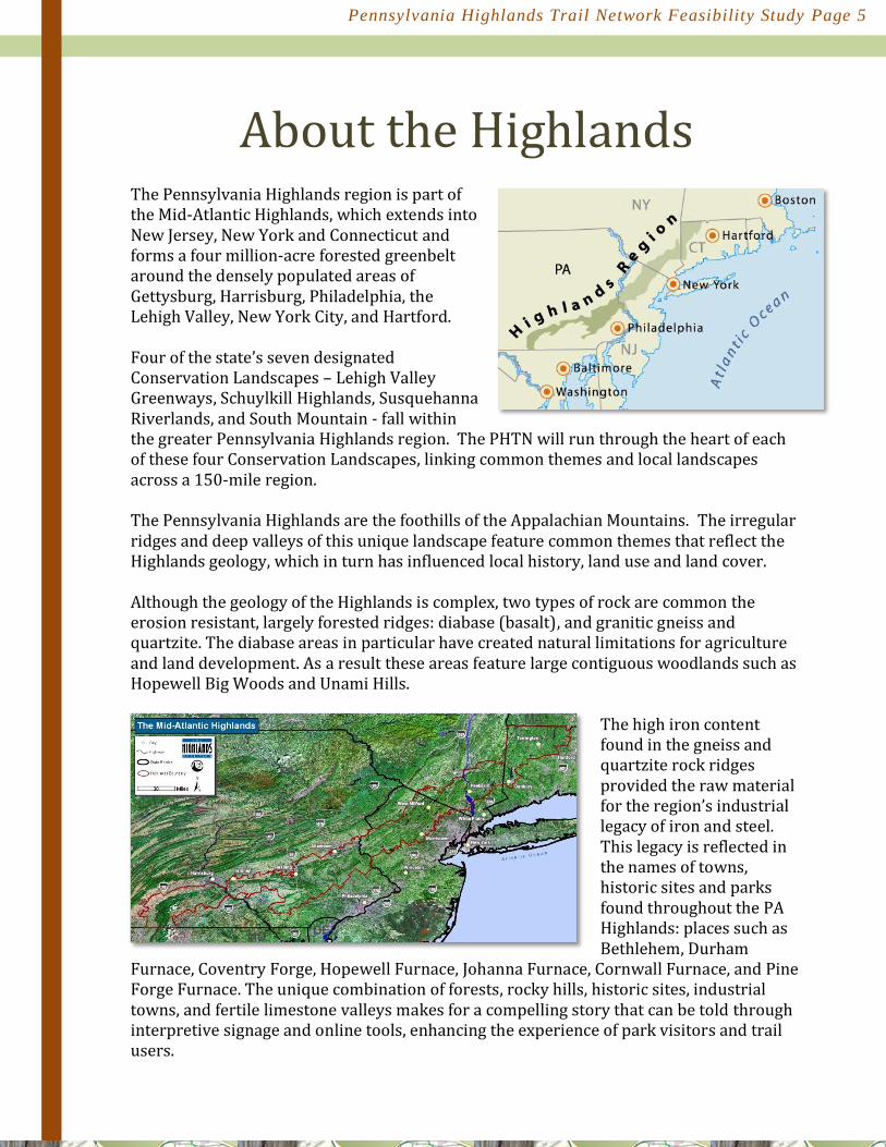
The Pennsylvania Highlands region is part of the Mid-Atlantic Highlands, which extends into New Jersey, New York and Connecticut and forms a four million-acre forested greenbelt around the densely populated areas of Gettysburg, Harrisburg, Philadelphia, the Lehigh Valley, New York City, and Hartford. Four of the state’s seven designated Conservation Landscapes – Lehigh Valley Greenways, Schuylkill Highlands, Susquehanna Riverlands, and South Mountain - fall within the greater Pennsylvania Highlands region. The PHTN will run through the heart of each of these four Conservation Landscapes, linking common themes and local landscapes across a 150-mile region. The Pennsylvania Highlands are the foothills of the Appalachian Mountains. The irregular ridges and deep valleys of this unique landscape feature common themes that reflect the Highlands geology, which in turn has influenced local history, land use and land cover. Although the geology of the Highlands is complex, two types of rock are common the erosion resistant, largely forested ridges: diabase (basalt), and granitic gneiss and quartzite. The diabase areas in particular have created natural limitations for agriculture and land development. As a result these areas feature large contiguous woodlands such as Hopewell Big Woods and Unami Hills.
The high iron content found in the gneiss and quartzite rock ridges provided the raw material for the region’s industrial legacy of iron and steel. This legacy is reflected in the names of towns, historic sites and parks found throughout the PA Highlands: places such as Bethlehem, Durham
Furnace, Coventry Forge, Hopewell Furnace, Johanna Furnace, Cornwall Furnace, and Pine Forge Furnace. The unique combination of forests, rocky hills, historic sites, industrial towns, and fertile limestone valleys makes for a compelling story that can be told through interpretive signage and online tools, enhancing the experience of park visitors and trail users.

Pennsylvania Highlands Trail Network Feasibility Study Page 6
The Appalachian Mountain Club (AMC) is working with many partner organizations as well as local, state and county governments to develop the Pennsylvania Highlands Trail Network (PHTN) within the 1.9 million-acre, 13 county Pennsylvania Highlands region. The plan to develop a trail through the Mid-Atlantic Highlands region began to take shape in the early 1990's when the New York-New Jersey Trail Conference began a multi-year effort to establish the NY/NJ Highlands Trail, covering over 160 miles from the Hudson River near Storm King Mountain to the Delaware River at Riegelsville, PA.
In 2006, AMC initiated discussions about extending the Highlands Trail into Pennsylvania when it convened two Roundtable Meetings at Nolde Forest and Kings Gap Environmental Education Centers. Participants included county planners, state park managers, land conservancies and recreational groups. These discussions helped to gage the potential and interest for a PA Highlands Trail Network. An outcome of the Roundtable Meetings was the formation of a region-wide PA Highlands Trail Steering Committee, which was created in 2007 with participants representing land trusts, state parks, trail organizations, and county planning commissions from across the PA Highlands Region. The Steering Committee participants helped form the vision and mission statements for the PHTN:
MISSION STATEMENT: To create a trail network that promotes and protects the Pennsylvania Highlands and provides communities with a physical connection to the outdoors through close-to-home recreation.
VISION: An interconnected trail network linking people to where they live in the Pennsylvania Highlands by providing recreational opportunities and protection of natural, scenic, and historical resources.

Pennsylvania Highlands Trail Network Feasibility Study Page 7
The PA Highlands Trail Steering Committee developed a conceptual PA Highlands Trail trunk route, focused on making connections between existing trails found throughout the PA Highlands region. This conceptual trail route was in part based on the realization that co-aligning with a network of existing trail systems in the PA Highlands would bring greater inter-connectedness and provide opportunities to link some of the outstanding natural and cultural features in the region, including several state parks, national historic sites and landmarks, numerous water trails, scenic vistas and revitalized downtowns. With input from the Roundtable Discussions, AMC's Geographic Information Specialists (GIS) produced a map of the PHTN conceptual trail route, identifying gaps that needed to be filled in between the major co-aligned trail systems. AMC also conducted a municipal outreach program to townships and boroughs in Bucks, Montgomery and Northampton Counties to discuss the Highlands Region and gather preliminary information about extending the NY/NJ Highlands Trail into Pennsylvania. The first PA Highlands Trail Network gaps to be identified exist between the Delaware River (D&L Trail) and the Perkiomen Trail, including portions of Bucks, Northampton, Lehigh and Montgomery Counties. To determine how to close these gaps, the PA Highlands Steering Committee was convened in 2008 to focus on the Buck-Northampton-Lehigh County area, with representation from local and regional partner organizations, county and municipal governments, and interested individuals. The Steering Committee, which has since expanded to include Montgomery County, has met on a regular basis to discuss PHTN trail routes and the progress of trail planning and construction activities taking place in this region. With the assistance of AMC’s GIS department, a database has been compiled of protected lands, including public open space owned by government and private nonprofits, private lands protected by conservation easements, and information about existing and planned greenways and trails. This data is publicly available through the PA Highlands Conservation Information Center, accessed through http://www.PAHighlandsTrail.org/ AMC and the New York-New Jersey Trail Conference co-hosted a trail celebration in Riegelsville, PA in 2009 to mark the official beginning of efforts to develop the PA Highlands Trail Network. A Highlands Trail marker was installed at the new footbridge over the Delaware Canal in Rieglesville. This event catalyzed efforts to continue the trail through Pennsylvania. An important step in the identification of potential trail routes in the easternmost portion of the Pennsylvania Highlands was completed in 2010 with the publication of the "Analysis of Protected and Unprotected Lands in Upper Bucks and Lower Northampton Counties for Potential Trail Easements as part of the Pennsylvania Highlands Trail Network." The information contained in the land analysis report combined with field surveys, identification of existing trails, and a series of trail planning meetings enabled the PHTN Steering Committee to identify potential routes to connect co-aligned trails. In 2011-2012 five Mid-Atlantic Highlands-PHTN interpretive kiosks were installed: adjacent to the canal footbridge in Rieglesville; Forks of the Delaware (Easton); Sand Island (Bethlehem); and the Perkiomen Trail at the Crusher Road access.

Pennsylvania Highlands Trail Network Feasibility Study Page 8
Letters of support for trail co-alignment with the PA Highlands Trail Network were provided by the City of Bethlehem (South Bethlehem Greenway), Montgomery County Parks and Cultural Heritage Services (Perkiomen Trail), D&L National Heritage Corridor (D&L Trail), and Horse-Shoe Trail Conservancy (Horse-Shoe Trail).

Pennsylvania Highlands Trail Network Feasibility Study Page 9
Introduction The purpose of the PHTN Feasibility Study Report is to describe the conceptual trail routes envisioned to be included as part of the PHTN in the Pennsylvania Highlands, from the Delaware River at Riegelsville (D&L Trail) to the Susquehanna River at Wrightsville (Mason-Dixon Trail), and on to the Appalachian Trail and the Maryland border.
Trail Signage and Stewardship There are a few existing trails, such as the D&L Trail and the Schuylkill River Trail, that can serve as models for the development of signage, maintenance and stewardship plans. Long distance trails tend to have multiple “owners,” and certain aspects of management can vary as a trail alternately traverses private, municipal, county, state or federally owned lands. The PHTN Trail Blaze-Logo will remain consistent with one that was created for use along the NY/NJ Highlands Trail (depicted below). Additional signage will be developed to serve specific purposes – for example, providing directional guidance and interpretive context – and in most cases will conform to the standards set by the owner of a particular stretch of trail (e.g. D&L Trail’s Visually Speaking Signage program). AMC will work with trail partners and the PHTN Steering Committee to develop interpretive signage that highlights the unique characteristics of the Pennsylvania Highlands and to develop other tools such as Quick Response Codes, mobile applications, and web-based content. AMC will work with PHTN partners to develop and implement a Stewardship Model to ensure long term maintenance and coordination among land managers.

Pennsylvania Highlands Trail Network Feasibility Study Page 10
This is a conceptual trail plan, and as such should be used as a beginning point for the next level of detailed planning and design for those sections of trail that are yet to be built or formalized. On the other hand, long stretches of the PHTN are envisioned to follow the route of well-established trails, and as such can be co-aligned and used now with little or no modification other than directional and/or interpretive signage. It is anticipated that some trail alignments initially identified in this report will change over time as new opportunities or challenges arise. This is consistent with the historic development patterns of long distance trails. Changes in physical conditions (i.e. flooding), land ownership (such as new easements, parks, public lands, etc.), and availability of funding and long- term support could bring about new opportunities and/or challenges to the establishment and maintenance of various PHTN routes. For the purposes of trail planning over a large region like the Pennsylvania Highlands, trail segments have been defined in part by opportunities for co-alignment with major trails such as the D&L and Perkiomen Trails. The PA Highlands region has been divided into six PHTN planning segments:
1) Riegelsville-Quakertown Region 2) Unami Hills-Perkiomen Trail 3) Perkiomen Trail-Horse-Shoe Trail 4) HorseShoe-Lebanon Valley-Conewago Trail 5) Conewago Trail-Mason Dixon Trail 6) Mason Dixon Trail-Appalachian Trail

Pennsylvania Highlands Trail Network Feasibility Study Page 11
As the trail route recommendations for each of the six PHTN segments are completed, they will be added to this Feasibility Study Report. It should be noted here that a Master Trail Plan will be developed for the Quakertown Region. The complexity of this area in terms of municipal boundaries and the heavily-used road network, as well as the opportunities to develop abandoned rail and trolley corridors and to connect existing trails, justifies a special planning effort for the Quakertown Region that goes beyond the series of planned PHTN feasibility Studies. Recommendations contained in the Feasibility Study Report are based upon: 1) suggestions offered at public meetings and the regular meetings of the Steering Committee; 2) mapping and research to identify existing trails, protected open space and parks; 3) review of municipal and/or county open space plans and identification of planned greenways and trails; 4) outreach and discussions with land owners; 5) opportunities to develop connections to outstanding scenic, historic and natural features; and 6) field investigations to assess the potential suitability of proposed trail routes. Potential trail routes identified thus far within the PHTN range in character from secluded, rugged footpaths through deep woods, to paved multi-use trails in urban settings and just about everything in between. Since it is not always possible to identify an off-road trail route to connect one location or trail system to another, interim road routes have been identified along lightly traveled public roads for some stretches of the PHTN. Proposed interim road routes are intended to be “share-the-road” as opposed to dedicated pedestrian or bicycle lanes.
Trail routes have not and will not be proposed to run through private parcels of land, except where a property owner has voluntarily granted an easement or written agreement for through access.

Pennsylvania Highlands Trail Network Feasibility Study Page 12
Segment #1 covers the region between the Delaware River at Riegelsville and the Quakertown Region, including portions of Bucks, Lehigh, and Northampton counties. This easternmost segment of the PA Highlands Trail Network will connect with and highlight an impressive number of natural, scenic and historic features, many of which are of national, regional, and state significance, including:
The Delaware & Lehigh National Heritage Corridor, The D&L Trail, Delaware Canal State Park, The Lower Delaware National Wild and Scenic River, The Delaware River Water Trail, The Lehigh River Water Trail, Nockamixon Cliffs Natural Area, Monroe Fault Natural Landmark, Ringing Rocks County Park, Nockamixon State Park, Riegelsville National Historic District, and Moravian National Historic Landmark (Bethlehem).
The NY/NJ Highlands Trail crosses into Pennsylvania at Riegelsville via the Roebling Bridge to connect with the D&L Trail. With a starting point at Rieglesville, the PHTN route planning presented a compelling choice to follow the D&L Trail in Delaware Canal State Park for some distance, to a point where the trail could begin heading in a westerly direction through the PA Highlands region. The PHTN Steering Committee recognized an opportunity to follow the D&L Trail in both directions (north and south), with the two routes ultimately reconnecting near the Borough of Quakertown. Therefore, trail planning for PHTN Segment #1 focused on both a ‘northern route’ and a ‘southern route’ to reach and connect with other major regional trails in the PA Highlands region, such as the Perkiomen Trail and Horse-Shoe Trail. Together, the PHTN Southern Route and PHTN Northern Route would form a mega-loop trail system between Riegelsville and Quakertown. In addition to the two conceptual trunk routes potential spur/loop routes were identified. The PHTN Segment #1 conceptual routes are described as follows, beginning with the Northern Route.

Pennsylvania Highlands Trail Network Feasibility Study Page 13

Pennsylvania Highlands Trail Network Feasibility Study Page 14
-
Northern Route The PHTN Northern Trunk Route would entirely follow historic canal and rail corridors, creating a multi-use stretch of the Highlands Trail between Riegelsville, the Lehigh Valley and Quakertown Borough. The Northern Trunk Route would present trail users with numerous opportunities to access the downtown areas of Easton, Bethlehem, Hellertown and Quakertown as well as several nearby communities. Much of this route would co-align with the D&L Trail and follow sections of the Delaware River and the Lehigh River; both rivers are state designated Water Trails. The PHTN Northern Route would run through the following municipalities (south to north): Borough of Riegelsville (Bucks County); Williams Township, City of Easton, Palmer Township, Borough of Freemansburg, Bethlehem Township, City of Bethlehem, Borough of Hellertown and Lower Saucon Township (Northampton County); Upper Saucon Township and Borough of Coopersburg (Lehigh County); Milford Township, Springfield Township, Borough of Quakertown, and Richland Township (Bucks County).
Northern Route Gaps and Challenges For the Northern Route to become a viable through-route for the Highlands trail, it would be necessary to close the following gaps: 1) the abandoned stretch of rail between the South Bethlehem Greenway and the Saucon Rail Trail and; 2) the abandoned SEPTA line between the southern end of the Saucon Rail Trail near Coopersburg (Bucks- Lehigh border) and California Road in Richland Township. The prospects for closing these two gaps are excellent. The City of Bethlehem is actively working to extend the South Bethlehem Greenway so that it connects through to the Saucon Rail Trail in Hellertown Borough. The Bucks County Bicycle Plan identifies the abandoned passenger rail line between Coopersburg and Quakertown as a “priority off-road spine” and the Quakertown Region Master Trails Plan will explore the potential for expanding the rail trail.
Northern Trunk Route Maps Map 1: Riegelsville to Easton Map 2: Easton to Bethlehem Map 3: Bethlehem to Bucks County Line Map 4: Bucks County Line to Quakertown

Pennsylvania Highlands Trail Network Feasibility Study Page 15
Northern Trunk Route Options
The Northern Trunk Route of the Highlands Trail begins at the Riegelsville Canal footbridge. It co-aligns with and follows the D&L Trail north within the Delaware Canal State Park to the Forks of the Delaware (Lehigh and Delaware River confluence) in the City

Pennsylvania Highlands Trail Network Feasibility Study Page 16
of Easton. The Northern Trunk Route continues along the D&L Trail through Easton and into Palmer Township.
Continuing along the D&L Trail (Lehigh Canal Towpath) from Palmer Township, the PHTN Northern Route passes through Bethlehem Township and the Borough of Freemansburg before entering the City of Bethlehem. The PHTN Northern Route crosses the Lehigh River on the Minsi Trail Bridge, and crosses Rt. 412 to connect with the South Bethlehem Greenway. The optional route would be to use the Fahy Memorial Bridge to cross the Lehigh River, allowing access to the Moravian Historic District and a connection to the South Bethlehem Greenway in the South Bethlehem Business District.

Pennsylvania Highlands Trail Network Feasibility Study Page 17
The PHTN Northern Route follows the South Bethlehem Greenway to a point just south of the Lynn Avenue Bridge. At that point there is a one-mile gap to the Saucon Rail Trail. The Northern Route picks up the Saucon Rail Trail at Bachman Street and follows it to Saucon Community Park. Upper Saucon Township and the Borough of Coopersburg will complete the remaining stretch of the Saucon Rail Trail between Community Park and Coopersburg, near the Bucks County Line.

Pennsylvania Highlands Trail Network Feasibility Study Page 18
An approximately 7.5-mile section of the abandoned rail line exists from the Bucks County border in Springfield Township to California Road in Richland Township. At that point there is a semi-active freight line operated by East Penn Railroad, which runs through the Borough of Quakertown and continues on to Perkasie and communities to the south (Telford-Souderton).

Pennsylvania Highlands Trail Network Feasibility Study Page 19
Existing Parks Along the Northern Route:
The following state, county and local parks will either be directly connected by the PA Highlands Trail Network or may provide opportunities for future connector trails. They are listed in geographical order from Rieglesville to Quakertown. Delaware Canal State Park: This 60-mile towpath (D&L Trail) consists of a natural surface for hiking and biking. This linear state park is managed by PA DCNR - Bureau of State Parks. The PA Highlands Trail extends north from Rieglesville along the D&L Trail to the Forks of the Delaware. This is the northern terminus of Delaware Canal State Park and the point where the D&L Trail begins following the Lehigh Canal. Wy-Hit-Tuk Park: Managed by Northampton County Department of Parks and Recreation the park is traversed by the D&L Trail and features access to the Delaware River. Camping is allowed by special permit. Hugh Moore Park: Situated between the Lehigh River and Lehigh Canal (D&L Trail) this park is the site of the Emrick Center, which is home to the National Canal Museum and offices of the D&L National Heritage Corridor. The park also features mule drawn canal boat rides. Pennsylvania Fish & Boat Commission River Access: Located off of Hope Road in Palmer Township (near the Rt. 33 overpass), this boat ramp provides access to the Lehigh River between Bethlehem and Easton. Sand Island Park: Located along the D&L Trail at the confluence of the Lehigh River and Monocacy Creek, this City of Bethlehem managed park includes access to the river and canal, tennis courts, and the Ice House, which serves as a space for cultural events. Bethlehem SkatePlaza: Owned and managed by the City of Bethlehem, this park is located along the South Bethlehem Greenway. The SkatePlaza is a state-of-the-art venue capable of supporting national skate and/or BMX events and serving as an event venue and gathering place. Water Street Park: Part of the Borough of Hellertown’s park system, Water Street Park serves as a trailhead for the Saucon Rail Trail and as the location of the Saucon Farmers Market. Grist Mill Park: This thirteen acre park in the Borough of Hellertown features a 19th century grist mill. Upper Saucon Community Park: This park serves as the main access in Upper Saucon Township to the Saucon Rail Trail. Parking and public restrooms are available.
Pennsylvania Highlands Trail Network Feasibility Study Page 20
Southern Route The PHTN Southern Trunk Route of the Highlands Trail follows the D&L Trail for approximately five miles before heading west through the iconic rural Highlands landscape of Bucks County. This route provides connectivity between county, local and state parks between Riegelsville and Quakertown, most notably the Delaware Canal State Park, Ringing Rocks County Park, and Nockamixon State Park. Bucks County and its municipalities have active land preservation programs, which will be valuable assets for closing trail gaps and connecting existing preserved lands. The PHTN Southern Route will be located in portions of the following municipalities in Bucks County: Borough of Riegelsville, Durham Township, Nockamixon Township, Bridgeton Township, Haycock Township, and Richland Township.
Southern Route Gaps and Challenges The Southern Route is the first area in the PA Highlands to be studied in depth to identify a viable trail route(s). In context to the entire expanse of the PA Highlands, this section presents one of the longer on-road gaps between established trail alignments on public lands and/or lands that have formal trail easements. This gap consists of a seven-mile stretch between Ringing Rocks County Park and Nockamixon State Park. An “interim road route” has been identified to connect Ringing Rocks County Park with Nockamixon State Park using lightly-traveled public roads (see Southern Route - Map 2). There are municipal parks and State Gameland #56 parcels within this area that could provide future opportunities to move portions of the “interim road route” to off-road trail sections. Moving the trail off-road could be accomplished over time by working with willing private landowners to establish trail and/or conservation easements, by identifying existing trails within the state gamelands, and by working to establish trail sections in already preserved land. A potential and unpredictable problem could be the closure of discrete sections of the D&L Trail due to Delaware River flooding. While this has occurred over the past several years, the trail closures due to flood damage have been relatively brief, typically a year or less. PA State Gamelands are managed by the PA Game Commission, with priorities of wildlife management and hunting. There are some opportunities to establish PHTN routes in State Gamelands where there are existing trails and logging roads. Major road crossings are located at: Route 32 River Road (Map #1), Marienstein Road (Map #2), and Easton Road - Rt. 611 at Tower Road (Map #2).
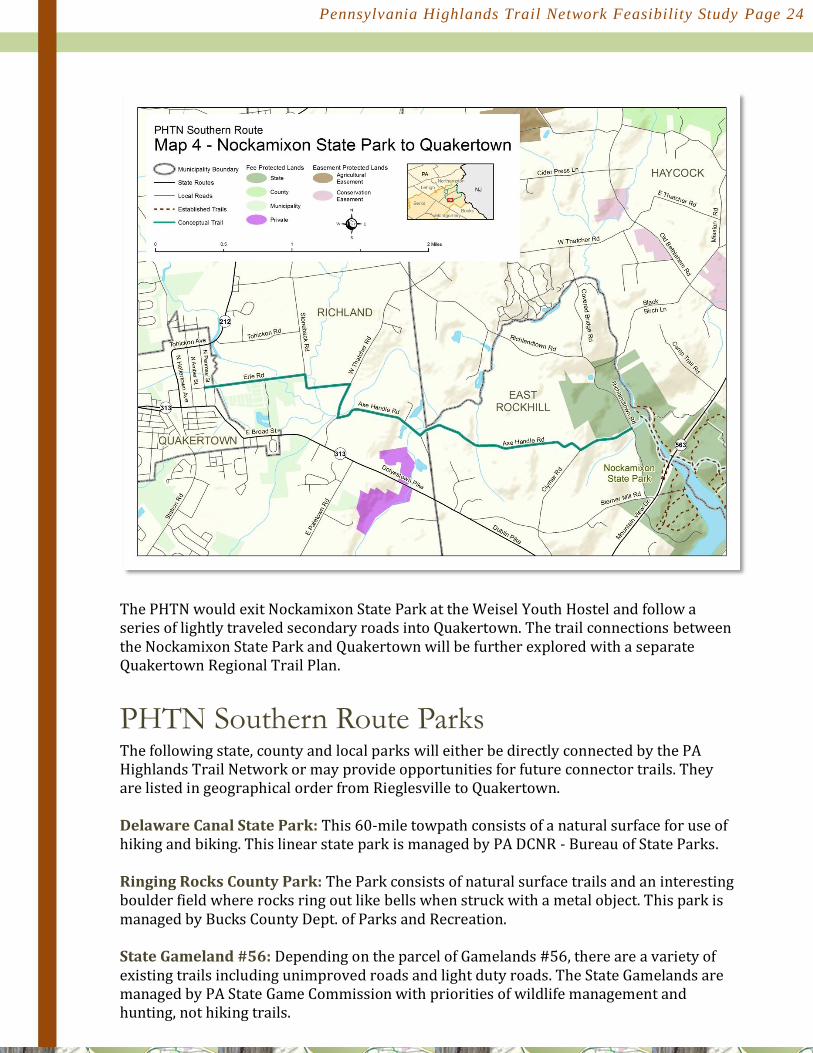
Southern Route Maps Map 1: Riegelsville to Ringing Rocks Map 2: Ringing Rocks to Nockamixon State Park (Tower Road) Map 3:Nockamixon State Park Map 4: Nockamixon State Park to Quakertown

Pennsylvania Highlands Trail Network Feasibility Study Page 21
Southern Trunk Route Options
The Southern Trunk Route of the Highlands Trail begins in the Borough of Riegelsville at the Riegelsville Canal Footbridge and follows the D&L Trail south for approximately five miles to the canal bridge and undeveloped parkland recently acquired by Bucks County (undeveloped parkland). At this point the Southern Route leaves the D&L Trail and begins to head west by crossing the canal bridge. The trail route follows a gravel driveway for approximately 150 yards to River Road (Rt. 32). Crossing River Road, the trail continues south on the footprint of a historic road-bed that runs parallel and immediately adjacent to River Road. The old road narrows to a wide trail and climbs out of the river valley parallel to and on the north side of High Falls Creek, and continues up the slope into Ringing Rocks County Park. Along the way, the trail passes the Ringing Rocks boulder field and emerges into the parking lot located on Ringing Rocks Road. It is envisioned that the stretch of trail between River Road and Ringing Rocks Park will be a footpath. An alternative bike route has been identified.

Pennsylvania Highlands Trail Network Feasibility Study Page 22
From the Ringing Rocks Park entrance, the PHTN southern route follows an “interim road route” that consists of approximately 7.5 miles of lightly traveled secondary roads through the scenic Beaver Run and Rapp Creek watersheds. This route connects with the Tower Road Trail Access Parking lot in Nockamixon State Park. Over time, the “interim road route” would be relocated to off- road locations on public land and/or through the establishment of easements on privately owned land.

Pennsylvania Highlands Trail Network Feasibility Study Page 23
At the Tower Road access, the PHTN Southern Route follows the Fire Road until it merges with the Mountain Bike Trail and continues north to Route 563. The trail continues along Rt. 563 West, crossing the Haycock Creek section of the lake and entering the Haycock Access where the trail picks up Old Haycock Road, a park service road. The trail turns right onto Tohickon Lane, an abandoned road that provides attractive views of Johns Pond and Lake Nockamixon. Tohickon Lane leads back to Rt. 563, where the trail would follow either the shoulder of Rt. 563, or a utility right-of-way that parallels the highway up to the Children’s Fishing Pond Trail, bypassing the Frisbee Golf Course. From the Pond parking lot, the PHTN Southern Route joins the trail system at the Marina Parking Lot and follows along Lake Nockamixon all the way to Rt. 563. The trail would cross over Tohickon Creek on the Rt. 563 bridge and follow the stairs down to the creek. The trail continues upstream along the High Bridge Trail for approximately one mile to the Weisel Youth Hostel.
Pennsylvania Highlands Trail Network Feasibility Study Page 24
The PHTN would exit Nockamixon State Park at the Weisel Youth Hostel and follow a series of lightly traveled secondary roads into Quakertown. The trail connections between the Nockamixon State Park and Quakertown will be further explored with a separate Quakertown Regional Trail Plan.
PHTN Southern Route Parks The following state, county and local parks will either be directly connected by the PA Highlands Trail Network or may provide opportunities for future connector trails. They are listed in geographical order from Rieglesville to Quakertown. Delaware Canal State Park: This 60-mile towpath consists of a natural surface for use of hiking and biking. This linear state park is managed by PA DCNR - Bureau of State Parks. Ringing Rocks County Park: The Park consists of natural surface trails and an interesting boulder field where rocks ring out like bells when struck with a metal object. This park is managed by Bucks County Dept. of Parks and Recreation. State Gameland #56: Depending on the parcel of Gamelands #56, there are a variety of existing trails including unimproved roads and light duty roads. The State Gamelands are managed by PA State Game Commission with priorities of wildlife management and hunting, not hiking trails.
Pennsylvania Highlands Trail Network Feasibility Study Page 25
Rapp Creek Park: The Park is managed by Nockamixon Township and includes natural surface trails for hiking. Bucks County Horse Park: The park is managed by a non-profit organization for the Bucks County Department of Parks and Recreation and features a natural surface trail system for equestrians.. The PHTN is not currently planned to connect with Horse Park but the potential exists to create connections to Nockamixon State Park and State Gameland #157. Nockamixon State Park: This state park is managed by the Pennsylvania Department of Conservation and Natural Resources - Bureau of State Parks and features approximately 35 miles of trails for hiking, horseback riding, and bicycling. The relatively new volunteer group Friends of Nockamixon State Park helps plan and maintain trails. Weisel Youth Hostel: Located within Nockamixon State Park and managed by Bucks County Department of Parks and Recreation, the Weisel Youth Hostel is located on a former 100 acre estate that is situated along a scenic stretch of Tohickon Creek. Lake Towhee County Park: Managed by Bucks County Department of Parks and Recreation, the trails within the park are a natural surface for hiking and horseback riding. Lake Towhee County Park can be accessed by Old Bethlehem Road. The park is located a short distance from Nockamixon State Park and State Gameland #157. State Gamelands #157: Both natural surface trails and unimproved roads exist in Gamelands 157. The State Gamelands are managed by PA State Game Commission with priorities of wildlife management and hunting, not hiking trails.

Pennsylvania Highlands Trail Network Feasibility Study Page 26
Spur Routes for Consideration Segment #1 - Northern Route There is currently one Northern Trunk Route spur trail under consideration. It would include an additional mile of the D&L Trail between the Minsi Trail Bridge and Fahy Memorial Bridge, and follow the Monocacy Creek between Sand Island and Illicks Mill Park. This spur route provides additional opportunities for interpreting the natural and cultural features that are unique to the Highlands Region.
Monocacy Spur Route
The Monocacy Spur Route would begin at the Minsi Trail Bridge, where the PHTN Northern Route leaves the D&L Trail to cross the Lehigh River. The spur route continues north along the D&L Trail to Sand Island at the confluence of the Monocacy Creek and Lehigh River. At this point, the PHTN northern route leaves the D&L Trail and follows the Monocacy Creek trail for approximately three miles to Monocacy Park and Illicks Mill (Fox Environmental Center). The Monocacy spur route offers access to the Moravian Quarter, a National Historic Landmark.
Segment #1 - Southern Route
There are three southern route spur trails that are under consideration for possible inclusion as part of the PA Highlands Trail Network:
1. Indian Rock Spur Route
The area between Nockamixon Cliffs and High Falls Creek features a number of historic logging and/or charcoal roads that offer numerous opportunities to develop a scenic network of trails. Most notable of these are the trails that follow each of the three larger tributaries that flow to the Delaware River: High Falls Creek, which runs through Ringing Rocks County Park, Tumble Falls Creek, and Wild Cat Run. The Indian Rock Trail includes a network of informal, established footpaths located along Wildcat Run near the southern end of the Nockamixon Cliffs. The trails are located almost exclusively on privately owned land and would require formal easements to allow public access for activities such as hiking or birding. These trails are generally well-established rugged footpaths, others are former cart paths that may have been used for logging or charcoal production. AMC is working with local landowners and regional land trusts to explore the potential for establishing conservation and/or trail easements in this area. The Indian Rock Trail itself is an ancient footpath that follows Wildcat Run along its course from the Indian Rock Inn up a steep and narrow ravine to Camp Kirby (Lions Club International) and Center Hill Road. Camp Kirby is a preserved property that is used by different organizations for recreational activities. Camp Kirby and an adjacent, privately- owned parcel contain a network of trails on the hillside that overlooks the Delaware River between Narrows Hill Road and Wildcat Run. From Camp Kirby, the Indian Rock trail could connect with the trail and logging road that traverses State Gameland #56 between Center Hill Road and the SGL #56 parking lot at Lake Warren.

Pennsylvania Highlands Trail Network Feasibility Study Page 27
This informal network of trails extends south of Narrows Hill Road along the wooded slopes above River Road and down to the proposed Ringing Rocks area of the PHTN Southern Route. This sparsely populated, little-used area has high potential for an exceptionally scenic and secluded trail network. Much of this conceptual loop trail system has been identified in county and township open space plans.
2. Nockamixon Lake – Top Rock Spur-Loop Route
The PHTN Southern Trunk Route follows a network of new and existing trails within Nockamixon State Park. At the eastern end of the route, the potential exists to establish a spur route between Nockamixon State Park and the well-known Top Rock Trail, which is located within State Gameland #157. This prominent boulder outcrop lies at the top of Haycock Mountain, which is the highest point in Bucks County. An existing trailhead for Top Rock is found along Top Rock Trail Road. This is a high- potential spur trail because it would be located entirely on state-owned land. Efforts to identify and map a route(s) are in progress. Establishing this spur route would require the cooperation of the PA Game Commission.
3. Lake Nockamixon – Rockhill Route
This potential route would extend the PHTN from the Tower Road access in Nockamixon State Park to East Rock Hill Township and Perkasie. It would follow the trail system located on the east side of Lake Nockamixon for the entire length of the lake. The trail would need to cross Route 313 to pick up Three Mile Run Road. This route could connect Nockamixon State Park with Perkasie, Sellersville and the East Branch Perkiomen Trail. The potential also exists to connect the two boroughs with trails in West Rockhill Township including the Butter Creek Greenway, which in turn would provide a connection to Milford Township and the main route of the PHTN.