Embed Size (px)
Citation preview
P1812 Relinquishment
_________________________________________________________________________________
_________________________________________________________________________ March 2016 Page 1
Exploration
P1812 Relinquishment Report
1 CONTENTS 1.0 Licence Information .................................................................................................... 2
2.0 Synopsis ..................................................................................................................... 4
3.0 Work Programme Summary ....................................................................................... 4
4.0 Database .................................................................................................................... 4
5.0 Prospectivity Update................................................................................................... 5
6.0 Further Technical Work .............................................................................................. 6
6.1 Reprocessing & Interpretation................................................................................................. 6
6.2 Geochemistry ........................................................................................................................ 12
6.3 Basin Modelling ..................................................................................................................... 13
7.0 Resource and Risk Summary ................................................................................... 15
8.0 Conclusions .............................................................................................................. 15
LIST OF FIGURES Figure 1: P1812 licence area, with identified prospect and relevant wells. 3 Figure 2: PMO Seismic Database – Coaster. 5 Figure 3: Updated PMO Seismic Database. 6 Figure 4: Terracube data over Bittern field 7 Figure 5: SiP reprocessed data over Bittern field. 7 Figure 6: Terracube data from Bittern into Central Graben 8 Figure 7: SiP reprocessed data 8 Figure 8: View over potential pathway from Bittern into Bell 9 Figure 9: SiP reprocessed dataset from Figure 8 9 Figure 10: Interpreted Skagerrak over Bittern field 10 Figure 11: Geoteric interpreted faulting at top Zechstein 11 Figure 12: Interpreted faulted Skagerrak and Smith Bank pods 11 Figure 13: Likely different sources for oils, core and cutting samples around the western margin. 12 Figure 14: Oil Family grouping. 13 Figure 15: Trinity view of potential fetch cells and migration pathways. 14 Figure 16: Jurassic Sum of Risk Index map 15
P1812 Relinquishment
_________________________________________________________________________________
_________________________________________________________________________ March 2016 Page 2
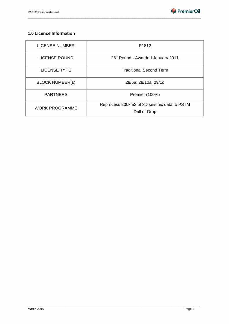
1.0 Licence Information
LICENSE NUMBER P1812
LICENSE ROUND 26th Round - Awarded January 2011
LICENSE TYPE Traditional Second Term
BLOCK NUMBER(s) 28/5a; 28/10a; 29/1d
PARTNERS Premier (100%)
WORK PROGRAMME Reprocess 200km2 of 3D seismic data to PSTM
Drill or Drop
P1812 Relinquishment
_________________________________________________________________________________
_________________________________________________________________________ March 2016 Page 3
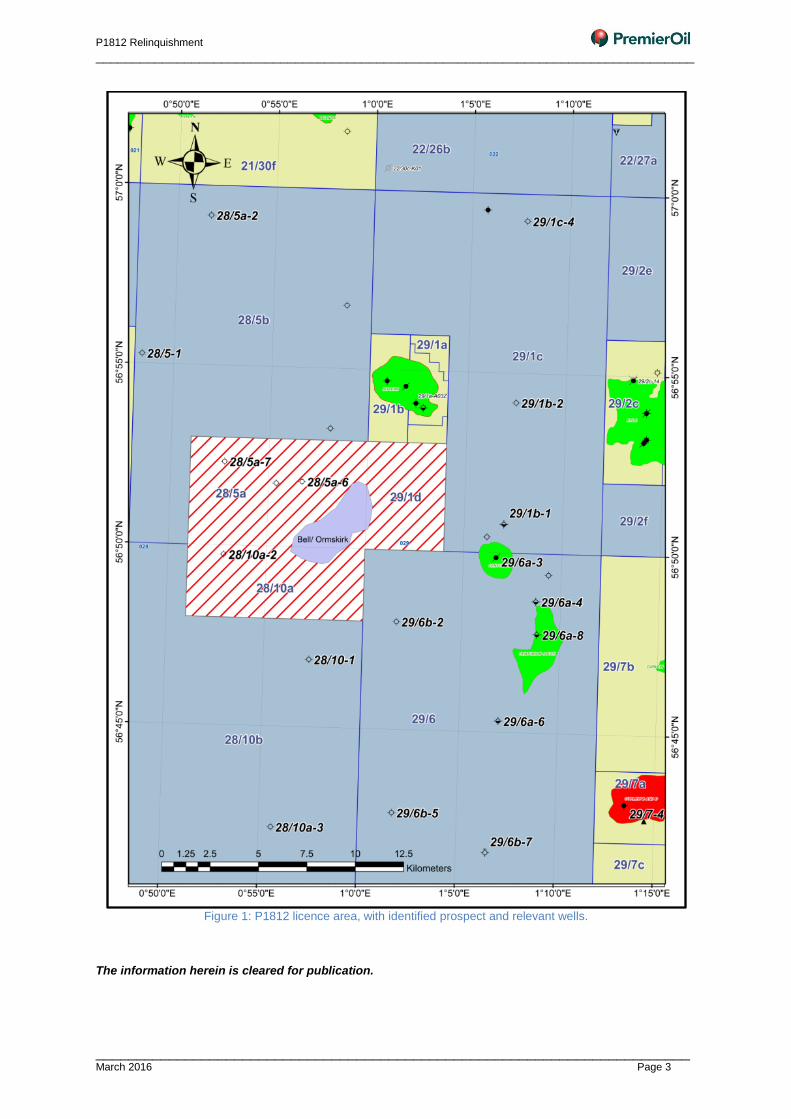
Figure 1: P1812 licence area, with identified prospect and relevant wells.
The information herein is cleared for publication.
P1812 Relinquishment
_________________________________________________________________________________
_________________________________________________________________________ March 2016 Page 4
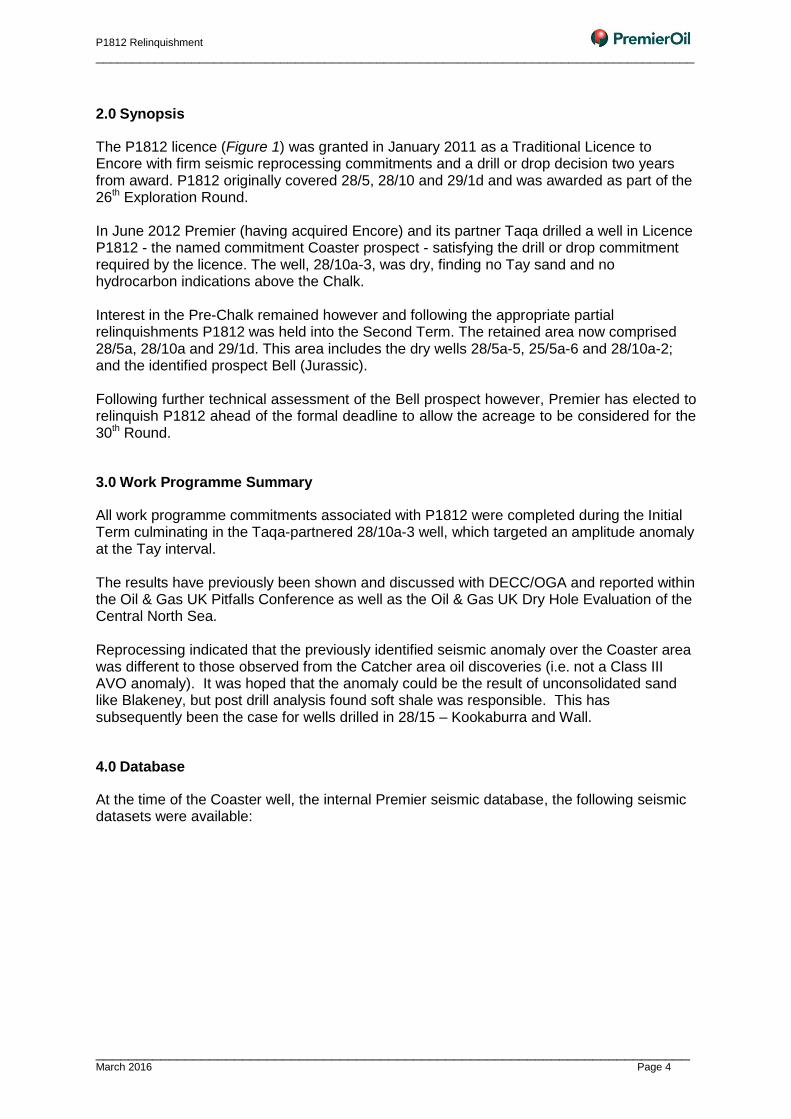
2.0 Synopsis
The P1812 licence (Figure 1) was granted in January 2011 as a Traditional Licence to Encore with firm seismic reprocessing commitments and a drill or drop decision two years from award. P1812 originally covered 28/5, 28/10 and 29/1d and was awarded as part of the 26th Exploration Round. In June 2012 Premier (having acquired Encore) and its partner Taqa drilled a well in Licence P1812 - the named commitment Coaster prospect - satisfying the drill or drop commitment required by the licence. The well, 28/10a-3, was dry, finding no Tay sand and no hydrocarbon indications above the Chalk. Interest in the Pre-Chalk remained however and following the appropriate partial relinquishments P1812 was held into the Second Term. The retained area now comprised 28/5a, 28/10a and 29/1d. This area includes the dry wells 28/5a-5, 25/5a-6 and 28/10a-2; and the identified prospect Bell (Jurassic). Following further technical assessment of the Bell prospect however, Premier has elected to relinquish P1812 ahead of the formal deadline to allow the acreage to be considered for the 30th Round.
3.0 Work Programme Summary
All work programme commitments associated with P1812 were completed during the Initial Term culminating in the Taqa-partnered 28/10a-3 well, which targeted an amplitude anomaly at the Tay interval. The results have previously been shown and discussed with DECC/OGA and reported within the Oil & Gas UK Pitfalls Conference as well as the Oil & Gas UK Dry Hole Evaluation of the Central North Sea. Reprocessing indicated that the previously identified seismic anomaly over the Coaster area was different to those observed from the Catcher area oil discoveries (i.e. not a Class III AVO anomaly). It was hoped that the anomaly could be the result of unconsolidated sand like Blakeney, but post drill analysis found soft shale was responsible. This has subsequently been the case for wells drilled in 28/15 – Kookaburra and Wall.
4.0 Database
At the time of the Coaster well, the internal Premier seismic database, the following seismic datasets were available:
P1812 Relinquishment
_________________________________________________________________________________
_________________________________________________________________________ March 2016 Page 5
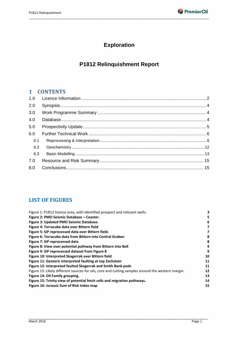
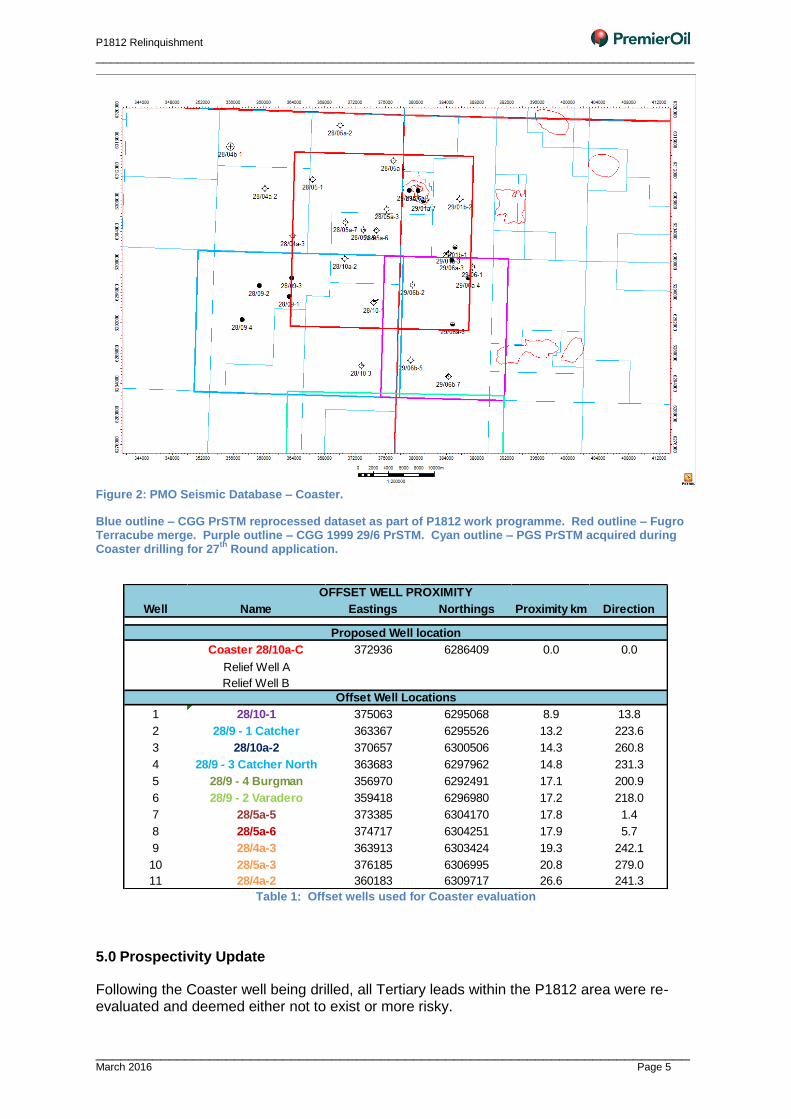
Figure 2: PMO Seismic Database – Coaster.
Blue outline – CGG PrSTM reprocessed dataset as part of P1812 work programme. Red outline – Fugro Terracube merge. Purple outline – CGG 1999 29/6 PrSTM. Cyan outline – PGS PrSTM acquired during Coaster drilling for 27
th Round application.
Table 1: Offset wells used for Coaster evaluation
5.0 Prospectivity Update
Following the Coaster well being drilled, all Tertiary leads within the P1812 area were re-evaluated and deemed either not to exist or more risky.
Well Name Eastings Northings Proximity km Direction
Coaster 28/10a-C 372936 6286409 0.0 0.0
Relief Well A
Relief Well B
1 28/10-1 375063 6295068 8.9 13.8
2 28/9 - 1 Catcher 363367 6295526 13.2 223.6
3 28/10a-2 370657 6300506 14.3 260.8
4 28/9 - 3 Catcher North 363683 6297962 14.8 231.3
5 28/9 - 4 Burgman 356970 6292491 17.1 200.9
6 28/9 - 2 Varadero 359418 6296980 17.2 218.0
7 28/5a-5 373385 6304170 17.8 1.4
8 28/5a-6 374717 6304251 17.9 5.7
9 28/4a-3 363913 6303424 19.3 242.1
10 28/5a-3 376185 6306995 20.8 279.0
11 28/4a-2 360183 6309717 26.6 241.3
OFFSET WELL PROXIMITY
Proposed Well location
Offset Well Locations
P1812 Relinquishment
_________________________________________________________________________________
_________________________________________________________________________ March 2016 Page 6
The remaining lead was Bell – a Jurassic inter-pod down-dip from the Bittern field (and Skagerrak discovery).
6.0 Further Technical Work
On progressing to the Second Term Premier internally approved a further work programme for Licence P1812 covering three main areas: reprocessing, geochemistry and basin modelling. The seismic interpretation and analysis for the work programme was based upon the Seismic Image Processing processed data from the original Amerada Hess AHL91 survey and Chevron HEX96 – covering 28/5 and 29/1 as well as the CGG Heritage data covering 28/9, 29/6 and 28/10.
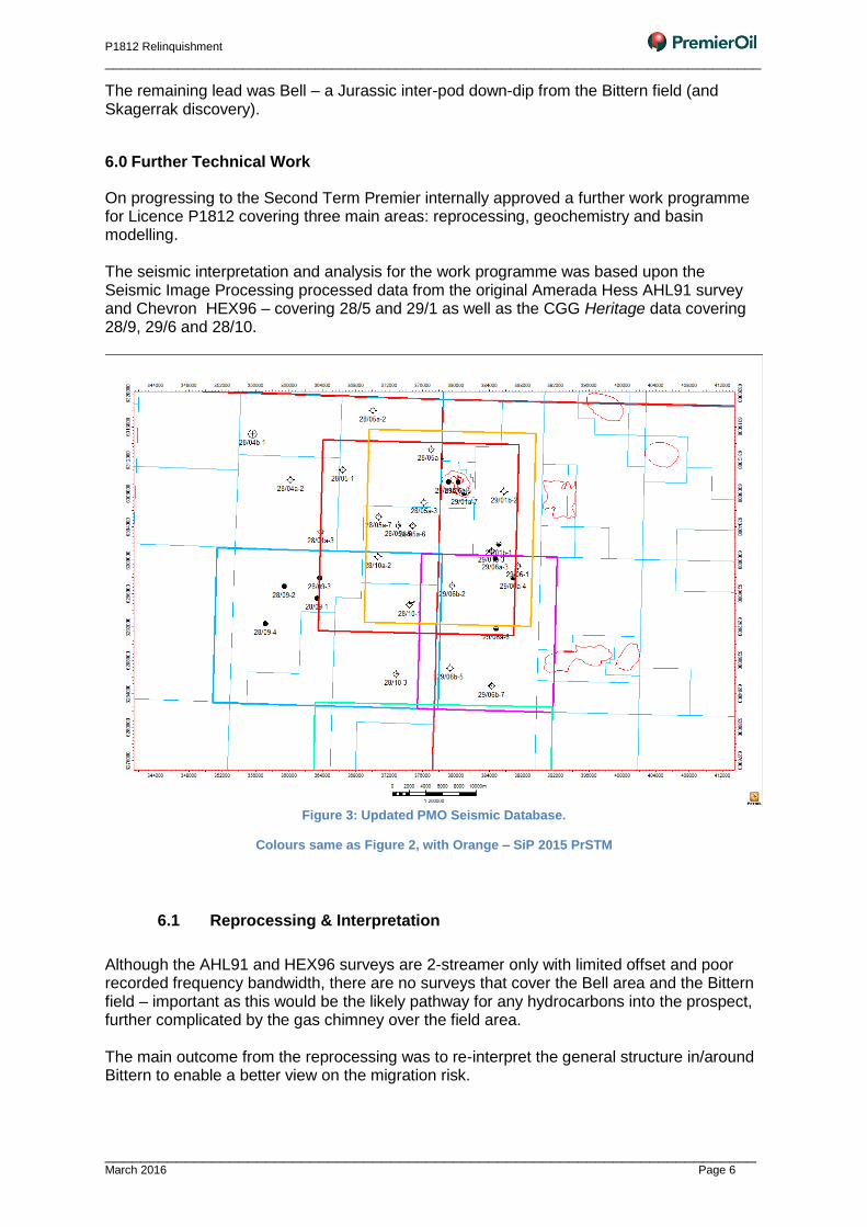
Figure 3: Updated PMO Seismic Database.
Colours same as Figure 2, with Orange – SiP 2015 PrSTM
6.1 Reprocessing & Interpretation
Although the AHL91 and HEX96 surveys are 2-streamer only with limited offset and poor recorded frequency bandwidth, there are no surveys that cover the Bell area and the Bittern field – important as this would be the likely pathway for any hydrocarbons into the prospect, further complicated by the gas chimney over the field area. The main outcome from the reprocessing was to re-interpret the general structure in/around Bittern to enable a better view on the migration risk.
P1812 Relinquishment
_________________________________________________________________________________
_________________________________________________________________________ March 2016 Page 7
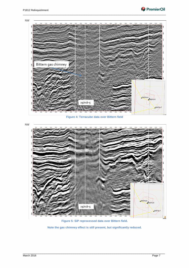
Figure 4: Terracube data over Bittern field
Figure 5: SiP reprocessed data over Bittern field.
Note the gas chimney effect is still present, but significantly reduced.
P1812 Relinquishment
_________________________________________________________________________________
_________________________________________________________________________ March 2016 Page 8
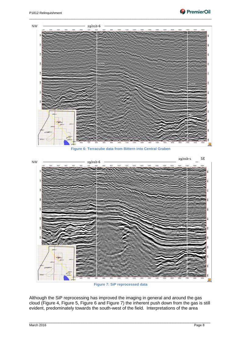
Figure 6: Terracube data from Bittern into Central Graben
Figure 7: SiP reprocessed data
Although the SiP reprocessing has improved the imaging in general and around the gas cloud (Figure 4, Figure 5, Figure 6 and Figure 7) the inherent push down from the gas is still evident, predominately towards the south-west of the field. Interpretations of the area
P1812 Relinquishment
_________________________________________________________________________________
_________________________________________________________________________ March 2016 Page 9
attempted to include corrections for this, though are somewhat limited by the lack of control points in the area.
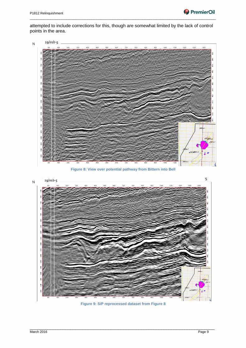
Figure 8: View over potential pathway from Bittern into Bell
Figure 9: SiP reprocessed dataset from Figure 8
P1812 Relinquishment
_________________________________________________________________________________
_________________________________________________________________________ March 2016 Page 10
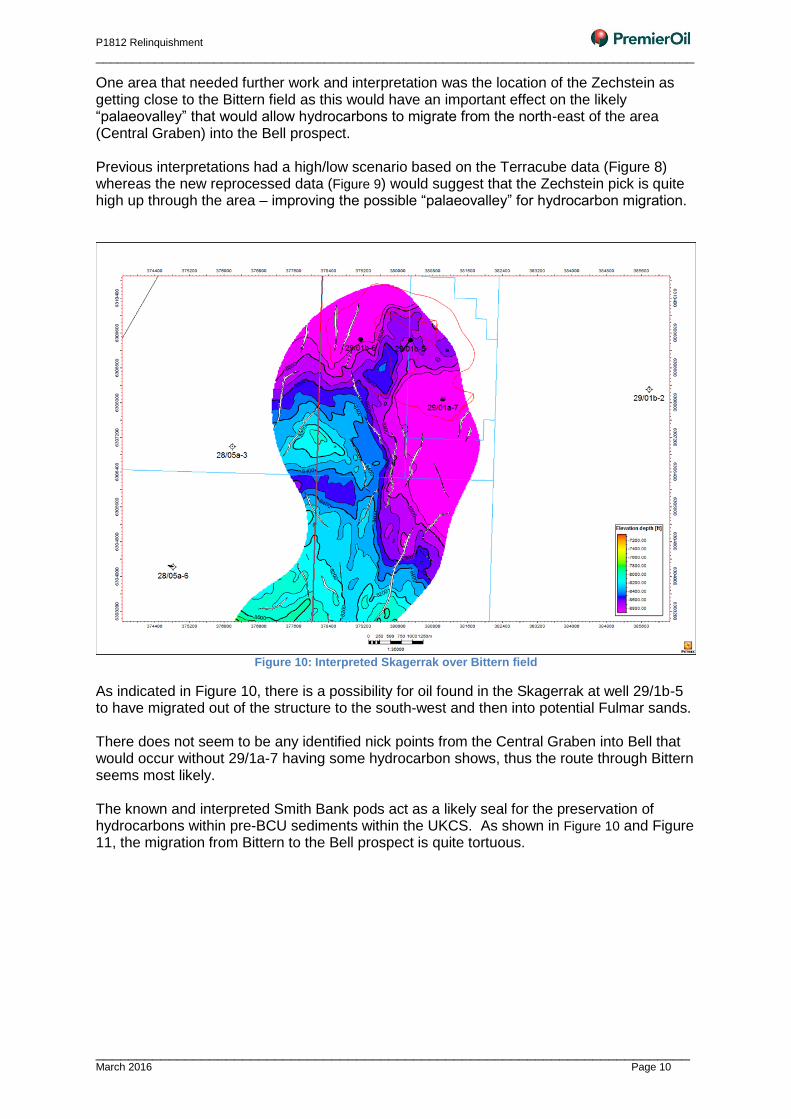
One area that needed further work and interpretation was the location of the Zechstein as getting close to the Bittern field as this would have an important effect on the likely “palaeovalley” that would allow hydrocarbons to migrate from the north-east of the area (Central Graben) into the Bell prospect. Previous interpretations had a high/low scenario based on the Terracube data (Figure 8) whereas the new reprocessed data (Figure 9) would suggest that the Zechstein pick is quite high up through the area – improving the possible “palaeovalley” for hydrocarbon migration.
Figure 10: Interpreted Skagerrak over Bittern field
As indicated in Figure 10, there is a possibility for oil found in the Skagerrak at well 29/1b-5 to have migrated out of the structure to the south-west and then into potential Fulmar sands. There does not seem to be any identified nick points from the Central Graben into Bell that would occur without 29/1a-7 having some hydrocarbon shows, thus the route through Bittern seems most likely. The known and interpreted Smith Bank pods act as a likely seal for the preservation of hydrocarbons within pre-BCU sediments within the UKCS. As shown in Figure 10 and Figure 11, the migration from Bittern to the Bell prospect is quite tortuous.
P1812 Relinquishment
_________________________________________________________________________________
_________________________________________________________________________ March 2016 Page 11
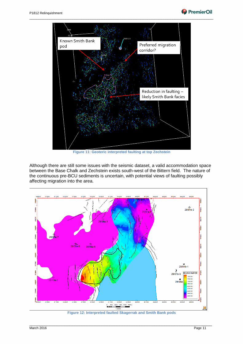
Figure 11: Geoteric interpreted faulting at top Zechstein
Although there are still some issues with the seismic dataset, a valid accommodation space between the Base Chalk and Zechstein exists south-west of the Bittern field. The nature of the continuous pre-BCU sediments is uncertain, with potential views of faulting possibly affecting migration into the area.
Figure 12: Interpreted faulted Skagerrak and Smith Bank pods
P1812 Relinquishment
_________________________________________________________________________________
_________________________________________________________________________ March 2016 Page 12
6.2 Geochemistry
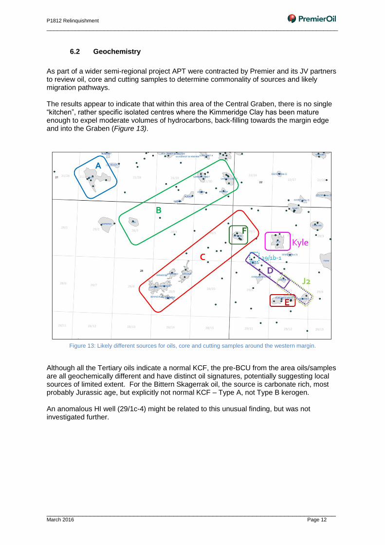
As part of a wider semi-regional project APT were contracted by Premier and its JV partners to review oil, core and cutting samples to determine commonality of sources and likely migration pathways. The results appear to indicate that within this area of the Central Graben, there is no single “kitchen”, rather specific isolated centres where the Kimmeridge Clay has been mature enough to expel moderate volumes of hydrocarbons, back-filling towards the margin edge and into the Graben (Figure 13).
Figure 13: Likely different sources for oils, core and cutting samples around the western margin.
Although all the Tertiary oils indicate a normal KCF, the pre-BCU from the area oils/samples are all geochemically different and have distinct oil signatures, potentially suggesting local sources of limited extent. For the Bittern Skagerrak oil, the source is carbonate rich, most probably Jurassic age, but explicitly not normal KCF – Type A, not Type B kerogen. An anomalous HI well (29/1c-4) might be related to this unusual finding, but was not investigated further.
P1812 Relinquishment
_________________________________________________________________________________
_________________________________________________________________________ March 2016 Page 13
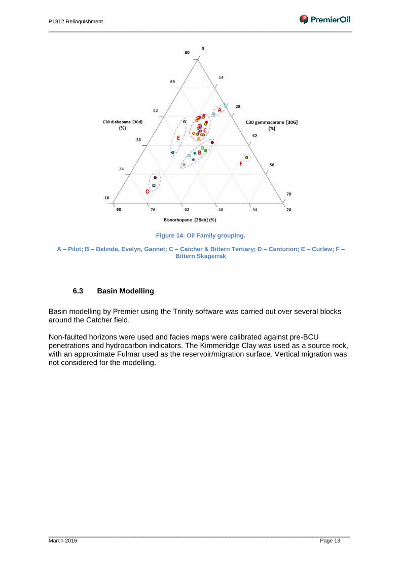
Figure 14: Oil Family grouping.
A – Pilot; B – Belinda, Evelyn, Gannet; C – Catcher & Bittern Tertiary; D – Centurion; E – Curlew; F – Bittern Skagerrak
6.3 Basin Modelling
Basin modelling by Premier using the Trinity software was carried out over several blocks around the Catcher field. Non-faulted horizons were used and facies maps were calibrated against pre-BCU penetrations and hydrocarbon indicators. The Kimmeridge Clay was used as a source rock, with an approximate Fulmar used as the reservoir/migration surface. Vertical migration was not considered for the modelling.
P1812 Relinquishment
_________________________________________________________________________________
_________________________________________________________________________ March 2016 Page 14
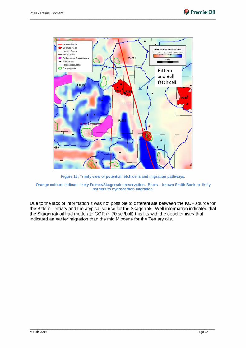
Figure 15: Trinity view of potential fetch cells and migration pathways.
Orange colours indicate likely Fulmar/Skagerrak preservation. Blues – known Smith Bank or likely barriers to hydrocarbon migration.
Due to the lack of information it was not possible to differentiate between the KCF source for the Bittern Tertiary and the atypical source for the Skagerrak. Well information indicated that the Skagerrak oil had moderate GOR (~ 70 scf/bbll) this fits with the geochemistry that indicated an earlier migration than the mid Miocene for the Tertiary oils.
P1812 Relinquishment
_________________________________________________________________________________
_________________________________________________________________________ March 2016 Page 15
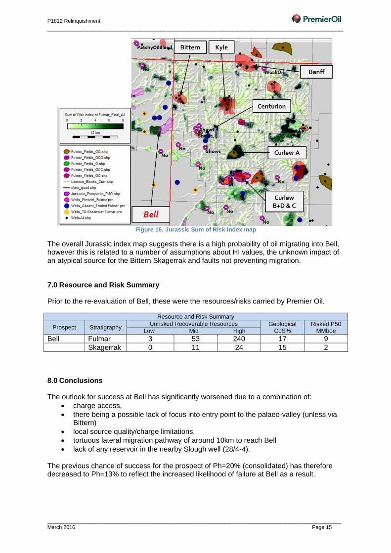
Figure 16: Jurassic Sum of Risk Index map
The overall Jurassic index map suggests there is a high probability of oil migrating into Bell, however this is related to a number of assumptions about HI values, the unknown impact of an atypical source for the Bittern Skagerrak and faults not preventing migration.
7.0 Resource and Risk Summary
Prior to the re-evaluation of Bell, these were the resources/risks carried by Premier Oil.
Resource and Risk Summary
Prospect Stratigraphy Unrisked Recoverable Resources Geological
CoS% Risked P50
MMboe Low Mid High
Bell Fulmar 3 53 240 17 9
Skagerrak 0 11 24 15 2
8.0 Conclusions
The outlook for success at Bell has significantly worsened due to a combination of:
charge access,
there being a possible lack of focus into entry point to the palaeo-valley (unless via Bittern)
local source quality/charge limitations.
tortuous lateral migration pathway of around 10km to reach Bell
lack of any reservoir in the nearby Slough well (28/4-4). The previous chance of success for the prospect of Ph=20% (consolidated) has therefore decreased to Ph=13% to reflect the increased likelihood of failure at Bell as a result.