Embed Size (px)
Citation preview

P U B L I C N O T I C E
CHARLESTON DISTRICT, CORPS OF ENGINEERS 69A Hagood Avenue
Charleston, South Carolina 29403-5107
REGULATORY DIVISION Refer to: P/N SAC-2016-01867-MOD4 December 1, 2021
Pursuant to Section 10 of the Rivers and Harbors Act (33 U.S.C. 403) and Sections 401 and 404 of the Clean Water Act (33 U.S.C. 1341), a proposed modification to the Palmetto Umbrella Mitigation Bank has been submitted to the Department of the Army (Corps) and the South Carolina Interagency Review Team (IRT) by
WEYERHAEUSER NR COMPANY ATTENTION: DOUG HUGHES
406 COLE ROAD HATTIESBURG, MISSISSIPPI 39402
for a proposal to add a stream and wetland mitigation site called Chicora Mitigation Site to Palmetto Umbrella Mitigation Bank that is adjacent to the
Cooper River
at a location near Lake Moultrie, approximately 10 miles west of the Francis Marion National Forest. More specifically, south of Highway 6, north of State Road (176), between Mudville and Cooper Store Roads, Summerville, Berkley County, South Carolina (Latitude: 33.2107 °, Longitude: -80.1204 °), Summerville Northwest and the Cross U.S. Geological Service Quadrangle sheets.
In order to give all interested parties an opportunity to express their views
N O T I C E
is hereby given that written statements regarding the proposed work will be received by the Corps until
30 Days from the Date of this Notice
from those interested in the activity and whose interests may be affected by the proposed work.
The proposed project consists of establishing a freshwater stream and wetland mitigation site in the Cooper River watershed (8-digit Hydrologic Unit Code 03050201) located in the Middle Atlantic Coastal Plain Ecoregion. The proposed 2,021-acre mitigation site includes approximately 43,199 linear feet of stream channels and 1,900 acres of wetlands.
The proposal is to preserve 7,779 linear feet of stream. In addition, restoration of 19,717 linear feet of stream will be achieved by redirecting flow from channelized portions back into

REGULATORY DIVISION December 1, 2021 SAC-2016-01867-MOD4
onsite relic channels and raising stream channels to reconnect with relic channels and floodplain. Stream Enhancement of 1,667 linear feet include stabilization and small channel improvements where full restoration is not needed or available. Wetland enhancement of 1,524.7 acres will include establishing native vegetation where commercial pine plantations have encroached or where vegetation has been disturbed. Approximately 194.2 acres of wetlands will be preserved on site. Once the mitigation work is complete, the bank sponsor proposes to monitor the mitigation site to ensure that the restoration areas are performing as expected and meeting the necessary performance standards. The bank sponsor, using a conservation easement held by Lord Berkeley Conservation Trust, will protect the mitigation bank site.
NOTE: This public notice and associated plans are available on the Corps’ website at:http://www.sac.usace.army.mil/Missions/Regulatory/PublicNotices .
According to the Prospectus, the proposed PS-WUMB will provide in-kind compensatory mitigation for authorized impacts to aquatic resources located within both the Upper and Lower Coastal Plain ecoregions as shown on the attached Service Area Map. The work required to complete the proposed activities on the mitigation site may be authorized under Nationwide Permit #27, after reviews by the Corps, the South Carolina Department of Health and Environmental Control, and the Interagency Review Team.
This notice initiates the Essential Fish Habitat (EFH) consultation requirements of the Magnuson-Stevens Fishery Conservation and Management Act. Implementation of the proposed project would not impact estuarine substrates and emergent wetlands utilized by various life stages of species comprising the shrimp, and snapper-grouper management complexes. The District Engineer’s initial determination is that the proposed action would not have a substantial individual or cumulative adverse impact on EFH or fisheries managed by the South Atlantic Fishery Management Council and the National Marine Fisheries Service (NMFS). The District Engineer’s final determination relative to project impacts and the need for mitigation measures is subject to review by and coordination with the NMFS.
Pursuant to Section 7(c) of the Endangered Species Act of 1973 (as amended), the District Engineer has consulted the most recently available information and has determined that the proposed project will have no effect on any federally endangered, threatened, or proposed species or result in the destruction or adverse modification of designated or proposed critical habitat. This public notice serves as a request for written concurrence from the U.S. Fish and Wildlife Service and/or the National Marine Fisheries Service on this determination.
In In accordance with Section 106 of the NHPA, the District Engineer has consulted South Carolina ArchSite (GIS), for the presence or absence of historic properties (as defined in 36 C.F.R. 800.16)(l)(1)), and has initially determined that no historic properties are present; therefore, there will be no effect on historic properties. To ensure that other historic properties that the District Engineer is not aware of are not overlooked, this public notice also serves as a request to the State Historic Preservation Office and other interested parties to provide any information they may have with regard to historic properties. This public notice serves as a request for concurrence within 30 days from the SHPO (and/or Tribal Historic Preservation Officer).
The District Engineer’s final eligibility and effect determination will be based upon coordination with the SHPO and/or THPO, as appropriate and required and with full
2

REGULATORY DIVISION December 1, 2021 SAC-2016-01867-MOD4
consideration given to the proposed undertaking’s potential direct and indirect effects on historic properties within the Corps-identified permit area.
Any person may request, in writing, within the comment period specified in this notice, that a public hearing be held to consider this application. Requests for a public hearing shall state, with particularity, the reasons for holding a public hearing.
The decision whether to approve or deny the proposed mitigation bank site will be based on an evaluation of the probable impact including cumulative impacts of the activity on the public interest The benefit which reasonably may be expected to accrue from the project must be balanced against its reasonably foreseeable detriments. All factors which may be relevant to the project will be considered including the cumulative effects thereof; among those are conservation, economics, aesthetics, general environmental concerns, wetlands, historic properties, fish and wildlife values, flood hazards, flood plain values, land use, navigation, shoreline erosion and accretion, recreation, water supply and conservation, water quality, energy needs, safety, food and fiber production and, in general, the needs and welfare of the people. In cases of conflicting property rights, the Corps cannot undertake to adjudicate rival claims.
The Corps is soliciting comments from the public; Federal, state, and local agencies and officials; Indian Tribes; and other interested parties in order to consider and evaluate the impacts of this activity. Any comments received will be considered by the Corps to determine whether to issue, modify, condition or deny a permit for this project. To make this decision, comments are used to assess impacts on endangered species, historic properties, water quality, general environmental effects, and the other public interest factors listed above. Comments are used in the preparation of an Environmental Assessment and/or an Environmental Impact Statement pursuant to the National Environmental Policy Act. Comments are also used to determine the need for a public hearing and to determine the overall public interest of the activity. Please submit comments in writing, identifying the project of interest by public notice number,to the following address:
US Army Corps of EngineersAttention: Regulatory Division
69A Hagood AvenueCharleston, South Carolina 29403
The Modification to the proposed mitigation bank is available for review by appointment between the hours of 9:00 am and 4:00 pm Monday through Friday at the address listed above. If there are any questions concerning the proposed mitigation bank or the information included in this public notice please contact David B. Wilson by e-mail at [email protected] or by telephone at 843-329-8044.
3

Pa
th:
C:\
Use
rs\t
im.t
ayl
or\
SW
CA
\SW
CA
-ER
ED
-D
ocu
me
nts
\63
33
9_
Big
Ru
nII
\GIS
\MX
D\1
Sit
e L
oc
atio
n.m
xd
World I GIS
Chicora Site (2,021 AC)
0 25 50 Miles
Chicora Mitigation Site: 33.2107, -80.1204
PALMETTO UMBRELLA MITIGATION BANKCHICORA MITIGATION SITEBerkeley County, South Carolina
FIGURE 1. SITE LOCATION
¨ Background: magery ( )Scale: 1:316,800 Created By: KRG Reviewed By: TJT SWCA Project No.: 63339Date Produced: August 20, 2021
NAD 1983 StatePlane South Carolina FIPS 3900 Feet
0 5 Miles
Kilometers 0 5 10
I c:,~
I ~
C I ~ ., "' !.a I loulln
I Cross
,., .,,,. §)- @
I
~ \ q.11 \ ~·
1~ i,-.. 7T
... ..
Plnopoli s
w,.,_.,n S, Moncks Comer
ti
-u rnbla _
Ca .!!!!_a lhv~ V
I
,, North
Ch r1 eston 0 ,. •~t Pleasant
Ch rles tonv
ij; Sav nn h -SWCA ENVIRONMENTAL CONSULTANTS
Ladson
~d
,.tial"~
"
@ ..,1 .....
... "' C i
I
I I
Johns Isl nd
Goose Creek
Belvedere Est tes
Han h n
700
171
Bonneau
M Pleasant
Charleston
t r• le n HJrliOr
I□
703
48
Sulliv ns lsl. nd
41
133
!kg Head r
Fr.m Na!or

Pa
th:
C:\
Use
rs\t
im.t
ayl
or\
SW
CA
\SW
CA
-ER
ED
-D
ocu
me
nts
\63
33
9_
Big
Ru
nII
\GIS
\MX
D\2
Ge
og
rap
hic
Se
rvic
e A
rea
s.m
xd
NAD 1983 StatePlane South Carolina FIPS 3900 Feet
Created By: PALMETTO UMBRELLA MITIGATION BANKCHICORA MITIGATION SITE Berkeley County, South Carolina
Reviewed By:
Date Produced:SWCA Project No.:
Scale:Background:
1:1,000,000
August 13, 202163339TJT
USGS Topographic Maps
03040205
03050201
03050207
03050206
03050112 03050205 03040207
03050111
03040202
03050208
03050209
03040204
03050202
03040206
03050110
03050104
03060110
03050210
03040201
03040208
03050203
03050204
03060109
0 10 20 Miles
0 20 40 Kilometers
¨ KRG
FIGURE 2. GEOGRAPHIC SERVICE AREAS
Chicora Site (2,021 AC)
Primary Geographic Service Area
Secondary Geographic Service Areas
Secondary Geographic Service Areas
Level III Ecoregion Southern Coastal Plain
Southeastern Plains
Middle Atlantic Coastal Plain
Chicora Site
SWCA ENVIRONMENTAL CONSULTANTS
-D
D
--
a

2020 I GIS
Chicora Site (2,021 AC)
Pa
th:
C:\
Use
rs\t
im.t
ayl
or\
SW
CA
\SW
CA
-ER
ED
-D
ocu
me
nts
\63
33
9_
Big
Ru
nII
\GIS
\MX
D\3
20
20
Ae
ria
l Im
ag
ery
.mxd
PALMETTO UMBRELLA MITIGATION BANKCHICORA MITIGATION SITE Berkeley County, South Carolina
FIGURE 3. 2020 AERIAL IMAGERY
¨ Background: magery ( )Scale: 1:30,000 Created By: KRG Reviewed By: TJT SWCA Project No.: 63339Date Produced: August 13, 2021
NAD 1983 StatePlane South Carolina FIPS 3900 Feet 0 0.25 0.5
Miles Kilometers
0 0.5 1
SWCA ENVIRONMENTAL CONSULTANTS

2020 I
Stream
Chicora Site (2,021 AC)
Wetland Type Freshwater Emergent Wetland
Freshwater Forested/Shrub Wetland
Freshwater Pond
Riverine
Pa
th:
C:\
Use
rs\t
im.t
ayl
or\
SW
CA
\SW
CA
-ER
ED
-D
ocu
me
nts
\63
33
9_
Big
Ru
nII
\GIS
\MX
D\4
NW
I.m
xd
PALMETTO UMBRELLA MITIGATION BANKCHICORA MITIGATION SITE Berkeley County, South Carolina
FIGURE 4. NATIONAL WETLANDS INVENTORY
¨ Background: magery Scale: 1:30,000 Created By: KRG Reviewed By: TJT SWCA Project No.: 63339Date Produced: August 13, 2021
NAD 1983 StatePlane South Carolina FIPS 3900 Feet 0
0
0.25 0.5 Miles
Kilometers 0.5 1
c:::J
SWCA ENVIRONMENTAL CONSULTANTS

REDIVERSION CANAL-SANTEE RIVER REDIVERSION CANAL-SANTEE RIVER
LAKE MARION-SANTEE RIVER
Pa
th:
C:\
Use
rs\t
im.t
ayl
or\
SW
CA
\SW
CA
-ER
ED
-D
ocu
me
nts
\63
33
9_
Big
Ru
nII
\GIS
\MX
D\5
Na
tion
al H
yd
rog
rap
hy
Da
tase
t.m
xd
LAKE MOULTRIE WADBOO CREEK DEAN SWAMP
Chicora Site
LOWER FOUR HOLE SWAMP
CYPRESS SWAMP
COOPER RIVER
Chicora Site (2,021 AC)
10 Digit HUC Boundaries
NHD Flowlines
Level III Ecoregion Southern Coastal Plain
Southeastern Plains ASHLEY RIVER
Middle Atlantic Coastal Plain
Background: USGS Topographic Maps Scale: 1:200,000
KRG Created By: PALMETTO UMBRELLA MITIGATION BANK TJTReviewed By:
63339 SWCA Project No.: ¨CHICORA MITIGATION SITE August 13, 2021 Date Produced:
NAD 1983 StatePlane South Carolina FIPS 3900 Feet Berkeley County, South Carolina 2 0 2
Miles FIGURE 5. NATIONAL HYDROGRAPHY DATASET Kilometers 0 2 4
-
·--1 L--
SWCA ENVIRONMENTAL CONSULTANTS
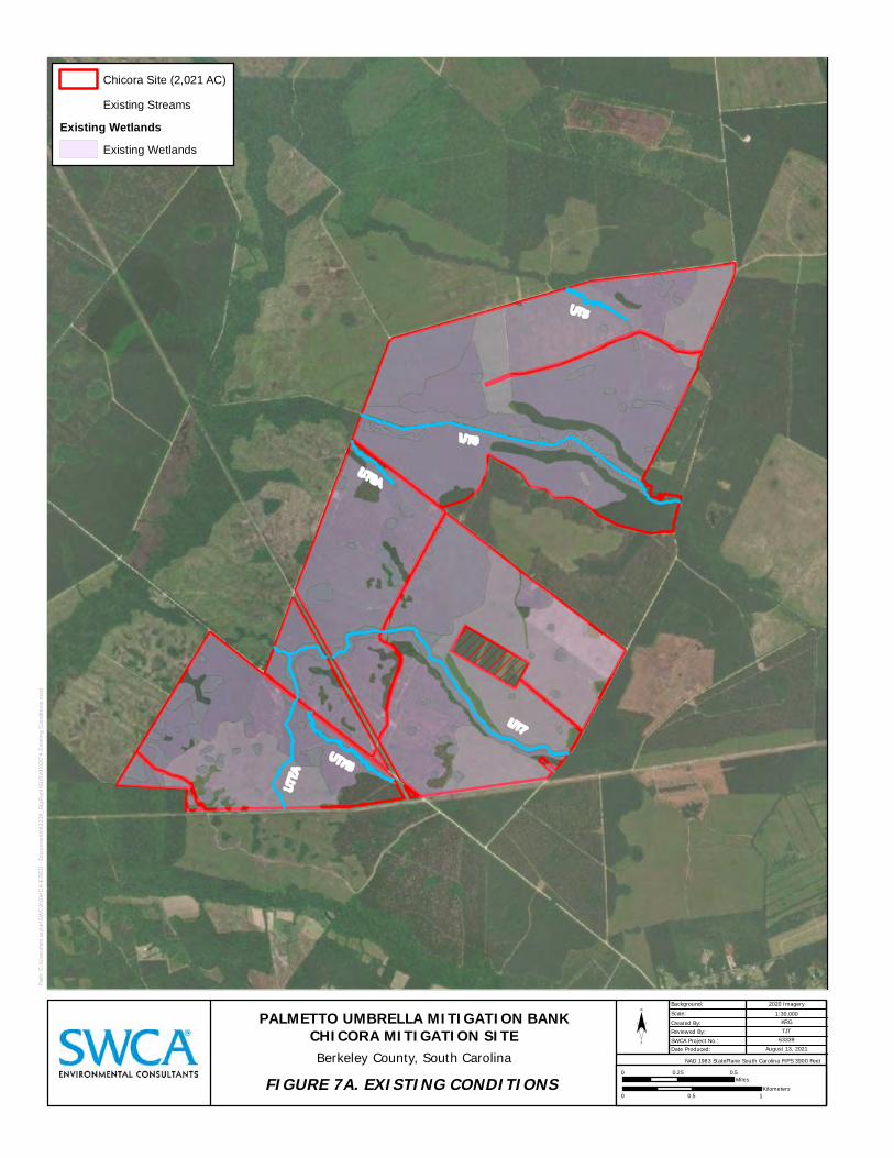
UT5
UT6
UT6A
UT7
A
UT7B
UT7
Chicora Site (2,021 AC)
Existing Streams
Existing Wetlands Existing Wetlands
2020 I
Pa
th:
C:\
Use
rs\t
im.t
ayl
or\
SW
CA
\SW
CA
-ER
ED
-D
ocu
me
nts
\63
33
9_
Big
Ru
nII
\GIS
\MX
D\7
A E
xist
ing
Co
nd
itio
ns
.mxd
PALMETTO UMBRELLA MITIGATION BANKCHICORA MITIGATION SITE Berkeley County, South Carolina
FIGURE 7A. EXISTING CONDITIONS
¨ Background: magery Scale: 1:30,000 Created By: KRG Reviewed By: TJT SWCA Project No.: 63339Date Produced: August 13, 2021
NAD 1983 StatePlane South Carolina FIPS 3900 Feet 0
0
0.25 0.5 Miles
Kilometers 0.5 1
D
SWCA ENVIRONMENTAL CONSULTANTS

Pa
th:
C:\
Use
rs\t
im.t
ayl
or\
SW
CA
\SW
CA
-ER
ED
-D
ocu
me
nts
\63
33
9_
Big
Ru
nII
\GIS
\MX
D\7
B E
xist
ing
Ve
ge
tatio
n.m
xd
2020 I
Chicora Site (2,021 AC)
Existing Streams
Existing Vegetation Bottomland Hardwoods
Cleared/Early Growth
Hardwoods
Mixed Pine/Hardwoods
Planted Pine
UT5
UT6
UT6A
UT7
UT7B
UT7
A
PALMETTO UMBRELLA MITIGATION BANKCHICORA MITIGATION SITE Berkeley County, South Carolina
FIGURE 7B. EXISTING VEGETATION
¨ Background: magery Scale: 1:30,000 Created By: KRG Reviewed By: TJT SWCA Project No.: 63339Date Produced: August 13, 2021
NAD 1983 StatePlane South Carolina FIPS 3900 Feet 0
0
0.25 0.5 Miles
Kilometers 0.5 1
D
1111
1111 1111
SWCA ENVIRONMENTAL CONSULTANTS
i
Chicora Site (2,021 AC)
Pa
th:
C:\
Use
rs\t
im.t
ayl
or\
SW
CA
\SW
CA
-ER
ED
-D
ocu
me
nts
\63
33
9_
Big
Ru
nII
\GIS
\MX
D\9
US
GS
To
po
gra
ph
ic.m
xd
PALMETTO UMBRELLA MITIGATION BANKCHICORA MITIGATION SITEBerkeley County, South Carolina
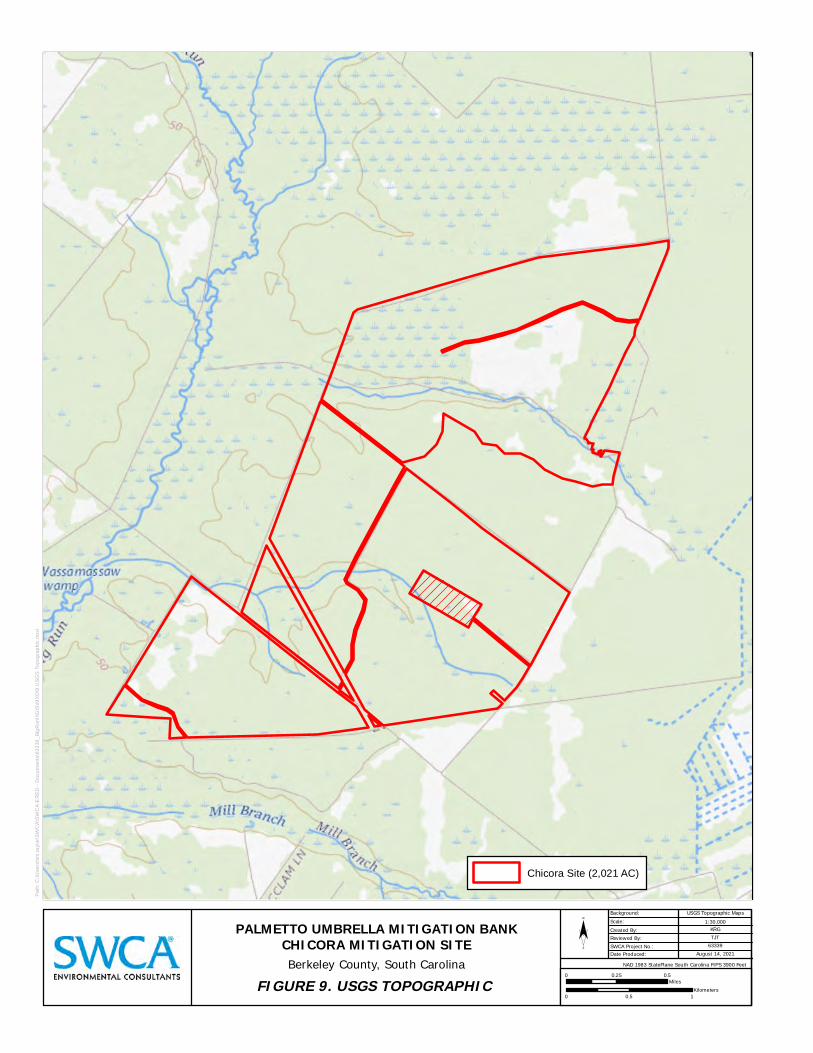
FIGURE 9. USGS TOPOGRAPHIC
¨ Background: USGS Topograph c Maps Scale: 1:30,000 Created By: KRG Reviewed By: TJT SWCA Project No.: 63339Date Produced: August 14, 2021
NAD 1983 StatePlane South Carolina FIPS 3900 Feet 0 0.25 0.5
Miles
Kilometers 0 0.5 1
---
SWCA ENVIRONMENTAL CONSULTANTS
till 81,.-c>,-, '·•C.'/1
1-1 -
, ,
, , , ,
' . , , , , , ,' ,
, I
,' ,f-
, .,,.

Pa
th:
C:\
Use
rs\t
im.t
ayl
or\
SW
CA
\SW
CA
-ER
ED
-D
ocu
me
nts
\63
33
9_
Big
Ru
nII
\GIS
\MX
D\1
1 M
itig
atio
n P
lan
.mx
d
2020 I
Chicora Site (2,021 AC)
Proposed Wetland Mitigation Enhancement
Preservation
Proposed Stream Mitigation Preservation
Restoration
UT5
UT6
UT6A
UT7
UT7B
UT7
A
PALMETTO UMBRELLA MITIGATION BANKCHICORA MITIGATION SITE Berkeley County, South Carolina
FIGURE 11. MITIGATION PLAN
¨ Background: magery Scale: 1:30,000 Created By: KRG Reviewed By: TJT SWCA Project No.: 63339Date Produced: August 14, 2021
NAD 1983 StatePlane South Carolina FIPS 3900 Feet 0
0
0.25 0.5 Miles
Kilometers 0.5 1
D ~ CJ
SWCA ENVIRONMENTAL CONSULTANTS

Pa
th:
C:\
Use
rs\t
im.t
ayl
or\
SW
CA
\SW
CA
-ER
ED
-D
ocu
me
nts
\63
33
9_
Big
Ru
nII
\GIS
\MX
D\1
2 B
uff
er
En
ha
nce
me
nt.
mxd
2020 I
Chicora Site (2,021 AC)
Stream Mitigation
Buffer Approach Enhancement, Cleared/Early Growth
Enhancement, Planted Pine
Enhancement, Road
Preservation, Bottomland Hardwoods
Preservation, Hardwoods
Preservation, Mixed Pine/Hardwoods
UT
5
UT6
UT
6A
PALMETTO UMBRELLA MITIGATION BANKCHICORA MITIGATION SITE Berkeley County, South Carolina
FIGURE 12A. BUFFER ENHANCEMENT
¨
Background: magery Scale: 1:12,000 Created By: KRG Reviewed By: TJT SWCA Project No.: 63339Date Produced: August 14, 2021
NAD 1983 StatePlane South Carolina FIPS 3900 Feet 0
0
1,000 Feet
Kilometers 0.5
SWCA ENVIRONMENTAL CONSULTANTS

Pa
th:
C:\
Use
rs\t
im.t
ayl
or\
SW
CA
\SW
CA
-ER
ED
-D
ocu
me
nts
\63
33
9_
Big
Ru
nII
\GIS
\MX
D\1
2b
Bu
ffe
r E
nh
an
cem
en
t.m
xd
2020 I
Chicora Site (2,021 AC)
Stream Mitigation
Buffer Approach Enhancement, Cleared/Early Growth
Enhancement, Planted Pine
Enhancement, Road
Preservation, Bottomland Hardwoods
Preservation, Hardwoods
Preservation, Mixed Pine/Hardwoods
UT7
UT7B
UT7A
PALMETTO UMBRELLA MITIGATION BANKCHICORA MITIGATION SITE Berkeley County, South Carolina
FIGURE 12B. BUFFER ENHANCEMENT
¨
Background: magery Scale: 1:12,000 Created By: KRG Reviewed By: TJT SWCA Project No.: 63339Date Produced: August 14, 2021
NAD 1983 StatePlane South Carolina FIPS 3900 Feet 0
0
1,000 Feet
Kilometers 0.5
CJ CJ 1111 CJ CJ 1111
SWCA ENVIRONMENTAL CONSULTANTS

UT5a
UT6a
UT7b
Worl GIS
Chicora Site (2,021 AC)
Reference Streams
Pa
th:
C:\
Use
rs\t
im.t
ayl
or\
SW
CA
\SW
CA
-ER
ED
-D
ocu
me
nts
\63
33
9_
Big
Ru
nII
\GIS
\MX
D\1
3a
Re
fere
nc
e S
ite L
oca
tion
.mxd
PALMETTO UMBRELLA MITIGATION BANKCHICORA MITIGATION SITE Berkeley County, South Carolina
FIGURE 13. REFERENCE REACH LOCATIONS
¨ Background: d Street Map ( )Scale: 1:30,000 Created By: KRG Reviewed By: TJT SWCA Project No.: 63339Date Produced: August 16, 2021
NAD 1983 StatePlane South Carolina FIPS 3900 Feet
0
0
0.5 Miles
Kilometers 1
D
SWCA ENVIRONMENTAL CONSULTANTS

Pa
th:
C:\
Use
rs\t
im.t
ayl
or\
SW
CA
\SW
CA
-ER
ED
-D
ocu
me
nts
\63
33
9_
Big
Ru
nII
\GIS
\MX
D\1
6 M
on
itori
ng
Pla
n.m
xd
2020 I
UT5
UT6
UT6A
UT7
UT7B
UT7
A
Water Quality
Geomorphology
Chicora Site (2,021 AC)
Proposed Wetland Mitigation Enhancement
Preservation
Proposed Stream Mitigation Preservation
Restoration
Monitoring Sites Vegetation Plots
PALMETTO UMBRELLA MITIGATION BANKCHICORA MITIGATION SITE Berkeley County, South Carolina
FIGURE 16. MITIGATION MONITORING
¨ Background: magery Scale: 1:30,000 Created By: KRG Reviewed By: TJT SWCA Project No.: 63339Date Produced: August 20, 2021
NAD 1983 StatePlane South Carolina FIPS 3900 Feet 0
0
0.25 0.5 Miles
Kilometers 0.5 1
D
0
SWCA ENVIRONMENTAL CONSULTANTS