Embed Size (px)
Citation preview
POST WORKS ASSESSMENT OF THE STREAM
RESTORATION PROJECT SITES AT UPPER WOODFORD
ON THE RIVER AVON
Summary of post works assessment following final site visit
on 9th April 2009
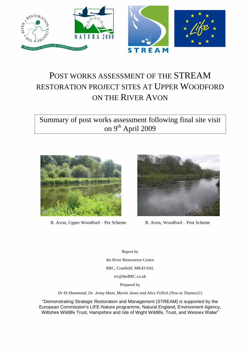
R. Avon, Upper Woodford – Pre Scheme R. Avon, Woodford – Post Scheme
Report by
the River Restoration Centre
RRC, Cranfield. MK43 0AL
Prepared by
Dr Di Hammond, Dr. Jenny Mant, Martin Janes and Alice Fellick (Now at Thames21)
“Demonstrating Strategic Restoration and Management (STREAM) is supported by the
European Commission's LIFE-Nature programme, Natural England, Environment Agency,
Wiltshire Wildlife Trust, Hampshire and Isle of Wight Wildlife, Trust, and Wessex Water”

Document Revisions
No. Details Date
1 Draft Report August 2009
2 Final Report September 2009

i
Contents
1. Introduction 3
1.1 STREAM Project Background 3
1.1.1 Project Specification 3
1.1.2 Restoration 4
1.2 Monitoring Requirements 4
1.2.1 Detailed Monitoring 5
1.2.2 Rapid Assessment Surveys 7
1.3 Aims and Objectives for the River Avon at Upper Woodford 9
2. Scheme Assessment 10
2.1 Site Description 10
2.2 Proposed Restoration Works 11
3. Assessment of Proposed Restoration and Likely
Outcomes 15
3.1 Pre Works 18
3.2 During Construction 19
3.3 As Built 19
3.4 Post Project 20
3.5 Reasons for Changes from Original Planned Works 23
3.5.1 Changes to Deflectors Post Restoration 23
3.5.2 Bank Works Post Restoration 24
4. Pre and Post Project Monitoring 25
5. Assessment of Methods Used 27
5.1 ‘D’ Deflectors 27
5.2 Islands 27
5.3 Causeway 29
6. Discussion and Recommendations 31
ii
6.1 Discussion 31
6.2 Lessons Learnt 31
6.3 Recommendations 32
7. References 33
Table 1.1 Overall project Operation and Monitoring Actions 5 Table 3.1 Summary of Changes in Water Level as a Result of the Hatch Operation Trials 17 Table 3.2 Summary of the Assessment of Scheme Outcomes 22 Table 3.3 Changes form Original Planned Works 23
Figure 2.1 Upper Woodford Site 12 Figure 2.2 Upper Woodford Reach 1 Photograph Locations 14 Figure 2.3 Upper Woodford Reaches 2, 3 and 4 Photograph Locations 14 Figure 3.1 Hatch Operation Trial Location of Water Level Recordings 17 Figure 3.2Figure 3.3 Restoration structures being built 20 Figure 3.4 Changes to ‘D’ Deflectors 23 Figure 5.1‘D’ deflector towards the lower end of Reach 2 (Photo Location 37) 27 Figure 5.2 New Island at the top of Reach 3 28 Figure 5.3 The Causeway at the Top of Reach 2 29 Figure 5.4 Restoration Features 30
Plate I Upper Woodford Pre Works Wide Channel with Uniform Flow 12 Plate II Upper Woodford Pre Works Existing Island 12 Plate IV Causway at the top of Reach 2 20 Plate V Island in Reach 2 20 Plate VI ‘D‘ Deflectors in Reach 2 20 Plate VII Deflector in Reach 3 20 Plate VIII Deflector Reduced in Size 23 Plate IX Pre Works 27 Plate X During Works 27 Plate XI As Built 27 Plate XII Post Works 27 Plate XIII Pre Works 28 Plate XIV During Works 28 Plate XV As Built 28 Plate XVI Post Works 28 Plate XVII Pre Works 29 Plate XVIII During Works 29 Plate XIX As Built 29 Plate XX Post Works 29 Plate XXI Fishing Pier Built Within ‘D’ Deflector just Upstream of Photo Location 31 30 Plate XXII Brushwood Ledge Reach 3 30
Appendix A River Restoration Assessment Sheetrs
3
1. Introduction
Introduction
The majority of the perennial River Avon catchment and part of one of the winterbournes (River
Till) in Hampshire is designated as a Special Area of Conservation (SAC). The River Avon is
one of the UK‟s most bio diverse, with over 180 species of aquatic plants, 37 species of fish and
a wide range of aquatic invertebrates. The headwaters of the main river are a network of clay
streams fed by chalk springs. These converge to form a chalk river, which is then joined by the
main tributaries around Salisbury developing into a large calcareous river. It then flows over
more acid sands and clay as it passes the New Forest and the Dorset Heaths. The SAC also
includes the Dockens Water, a largely unmodified acid stream draining New Forest heathlands.
The River Avon has a high baseflow input from the chalk aquifer. In the upper reaches of the
system, the rivers support outstanding chalk stream fisheries, and the surrounding land is mainly
grazed or arable. In the lower reaches of the Avon, the river is known for its coarse fishery and
the floodplain is of international importance for wintering wildfowl and waders. The river is
highly valued throughout for its flora and fauna, and is the subject of a range of conservation,
fishery and agricultural initiatives.
The SAC designation is due to the inherent richness of flora and fauna of the River Avon.
Specifically the reviser is designated for the following internationally rare or vulnerable species
and habitat underpin the designation.
• Water courses of plain to montane levels with Ranunculion fluitantis and
Callitricho-Batrachion vegetation (classic chalk stream habitat)
• Population of Atlantic salmon (Salmo salar)
• Population of bullhead (Cottus gobio)
• Population of brook lamprey (Lampetra planeri) and sea lamprey (Petromyzon
marinus)
• The river and adjoining land a habitat for populations of Desmoulin‟s whorl snail
(Vertigo moulinsiana)
The River Avon SAC is subject to a water level management plan, and an action plan for the
SSSI‟s restoration needs was completed as part of the Environment Agency (EA) assessment of
the cost to meet the Public Service Agreement (PSA) target for river morphology (EA 2008).
1.1 STREAM Project Background
1.1.1 Project Specification
The STREAM project was a £1 million four-year conservation project centered on the River
Avon and the Avon Valley in Wiltshire and Hampshire. The River Avon and its main tributaries
are designated as a Special Area of Conservation (SAC), and the Avon Valley is designated as a
Special Protection Area (SPA) for birds. The STREAM project has undertaken strategic river
restoration activities and linked management of the river and valley to benefit the river habitat
4
including water crowfoot and populations of Atlantic salmon, brook and sea lamprey, bullhead,
Desmoulin's whorl snail, gadwall and Bewick's swan.
A Conservation Strategy for the River Avon Special Area on Conservation (2003) identified the
main issues affecting the ecological health of the River Avon SAC, and agreed on a range of
actions required to address them. It also highlighted the complex relationship between the river
and the Avon valley.
In December 2002, work began on securing substantial new funding to do the following:
• Restore, to favourable condition, the River Avon Special Area of
Conservation/Special Site of Scientific Interest (SSSI) and the Avon Valley Special
Protection Area/SSSI.
• Tackle wider biodiversity issues outside the European protected sites including
additional priority species and associated habitats, and
• Improve public access, awareness and support for the natural heritage importance
of the river and valley.
The project identified 6 sites where conservation-led restoration of the watercourse habitat is
required, and which could subsequently be used to demonstrate techniques and disseminate
knowledge and experience of this work. For the application submission, an outline design for
each site has been drawn up.
1.1.2 Restoration
The approach to the restoration works is to reinstate the physical form and diversity of the river
channel, creating dynamic habitats that are sustained by the river‟s natural flow regime. The
aim of the works was to demonstrate novel and appropriate restoration techniques for the chalk
river types within the River Avon SAC, but the approach should be applicable to other rivers
supporting Ranunculion fluitantis /Callitricho-Batrachion communities.
Works included bank re-profiling to a more natural slope, non-native tree felling and native tree
planting, reconnecting the river to its floodplain, and enhance currently poor marginal habitat,
which is known to be critical to fish and invertebrates in lowland rivers.
The key objective of the restoration work was to demonstrate a range of bio-engineering
techniques useful for the narrowing of river channels. The range of techniques should then
provide a „tool-box‟ that fishing clubs could carry out themselves to help integrate the needs of
riparian ecology with fishery management.
1.2 Monitoring Requirements
The project bid identified a number of actions which were identified. These fell into a number
of categories including;
• Preparatory actions (Actions A)
• Purchase/lease of land and/or rights (Actions B)
• Non-recurring management (Actions C)
• Recurring management (Actions D)
5
• Public Awareness and dissemination of results (Actions E)
• Overall project operation and monitoring (Actions F)
Of the overall project operation and monitoring actions (see Error! Reference source not
found.), action F8 relates to monitoring.
Table 1.1 Overall project Operation and Monitoring Actions
Code Title and Actions Objectives
F1 Appointment of Project Management Team Set up an effective LIFE project team
F2 Project Management, including management of Project Staff
Ensure all project actions are executed to fulfil the objectives of the LIFE project within the allocated budget
F3 Project Reporting Reporting progress of project to the EU
F4 Management of the Project actions and budget by Project Working and Steering Group
To provide overall direction to the project.
F5 Purchase equipment To equip the LIFE team so they can effectively carry out the project
F6 Purchase car Allow the LIFE team to travel around the catchment and liaise with key stakeholders
F7 Project Initiation Workshop To launch the project and facilitate a good working relationships between all partners.
F8 Monitoring Programme To monitor success of the river restoration work and disseminate findings.
F9 Assessment of River Restoration Sites Compare the River Restoration project outcomes with the original objectives
F10 Production of After-LIFE Conservation Plan To set out future conservation management continuing and developing the actions in this Project
1.2.1 Detailed Monitoring
Royal Haskoning were commissioned by Natural England to undertake physical and biological
monitoring at each of the restoration sites. A monitoring protocol was developed for the river
restoration works. This combined detailed monitoring at a limited number of sites, with a more
rapid assessment of the remainder. The full detailed monitoring was carried out and Upper
Woodford and Seven Hatches sites. At Fovant and Hale only the rapid assessment was carried
out, but was also conducted at Upper Woodford and Seven Hatches. The rationale behind this
was to minimise costs while ensuring basic assessment of the effects of the range of restoration
techniques carried out by the Project.
All sites were monitored pre and post restoration. Detailed monitoring was carried out on two
restoration sites, each with a control site. The control sites had comparable physical
characteristics to the restoration sites prior to the works; however, no restoration works were
carried out on the control sites. The remaining restoration sites were subject to a less detailed
monitoring assessment. Field mapping was converted into a suitable digital GIS format to
allow calculation of the areas of habitats within the reaches from which it was possible to
monitor change following repeat surveys. The GIS recorded physical and ecological features,
sample and cross-section locations and any other spatial data collected in the field.
6
The pre-restoration surveys were intended to establish a record of biological and physical
conditions at the site prior to restoration. The post-restoration surveys were to record
modifications to the channel after restoration. The surveys both provided snapshots pre- and
post-restoration. It should however be recognised that there is a limitation to the comparisons
that can be made over this short duration and it was not possible to draw any conclusions
regarding changes in conditions at a site pre / post-restoration. The relationship between
physical and biological conditions were analysed at each site and comparisons drawn
concerning the relationships identified at each site at the time of survey, taking into account
other factors and processes that might have influenced relationships.
The detailed monitoring comprised the following techniques;
• Geomorphological and habitat baseline surveys;
• Cross section surveys;
• In channel macrophyte survey;
• Fisheries surveys;
• Fixed point photography.
Geomorphological and Habitat Baseline
Geomorphological and Habitat Baseline survey included the river bed, banks and a riparian
zone not less than 5 m from the bank edge (subject to the nature of the adjacent habitats). Thus
the mapping extended beyond 5m where an adjacent habitat is specifically a riverine wetland or
where the restoration works restore connections between the floodplain and the channel.
Geomorphological mapping was at a suitable scale, and covered the detail of the channel
geomorphology, evidence of geomorphological processes, bed materials and vegetation cover.
Habitat mapping included the vegetation structure and species composition recorded in a way
that allows comparative assessment in subsequent years following colonisation of the restored
or modified reaches.
Cross-section Survey
Cross-section surveys will be undertaken through each reach at a maximum spacing of three
bankfull channel widths for a maximum length of 1000m. Survey within each cross-section will
seek to capture habitat boundaries and morphologically defined features in addition to water
surface elevation.
In-channel Macrophyte Survey
A Macrophyte survey (to include Ranunculus spp, Callitriche spp and associated community)
was undertaken with relevant spatial data presented in GIS formats. This will include;
• Cross sectional survey of vegetation cover (%);
• Species quadrats at 5 cross-sections at each site ;
• Reach-based overview maps.
7
Fish Survey
Fishery survey for Salmo salar, Petromyzon marinus, Lampetra planeri and Cottus gobio were
undertaken within the restored and control reaches. The survey design will reflect the
complexity of the riverine environment, with sampling from within different habitats within the
watercourse. The sampling framework will be based on the habitat mapping.
It is intended that any fish survey would be undertaken completely within the field, with no
specimens taken and all material returned to the river. Species and size classes will be
identified.
Fixed Point Photography
Repeat photography was undertaken at each reach from fixed point locations. These survey
points needed be re-locatable and were thus be recorded by a 12 figure grid reference together
with the bearing of the view established by a Geographical Positioning System (GPS). Such
data was provided as a GIS point layer with an appropriate file structure to allow for hot-linking
within a GIS.
As well as the detailed mapping, rapid assessment techniques were also employed at all the
sites. The rapid assessment of the remaining restoration sites will use the following techniques;
• Feature inventory survey;
• Basic habitat mapping;
• Fixed point photography.
Feature Inventory Survey
The remaining restoration sites were audited using a standard feature inventory form. This
approach was been developed and deployed on the River Cole restoration project and used to
estimate physical habitat diversity (Sear et al. 1998). A tally of all physical habitat features
within the channel (pool, riffle, eroding cliff etc.) is recorded. This survey was undertaken at
the same time as the main monitoring programme during the autumn when vegetation has died
back.
Basic Habitat Mapping
The watercourse habitat and surrounding terrestrial habitats were mapped using UK biodiversity
habitat types.
Fixed point photography
Fixed Point photography was undertaken as for the detailed monitoring sites.
1.2.2 Rapid Assessment Surveys
In addition to the Royal Haskoning monitoring, the River Restoration Centre (RRC) also
carried out a series of rapid assessment surveys. The surveys were planned to be carried out pre,
during, just after (as built) and post the restoration works. Examples of the RPPA forms can be
seen in Appendix A. The project was divided into physically distinct reaches each of which was
assessed separately. The reaches include one or more upstream of the restoration (recording
upstream impact) and one or more downstream of the restoration (again recording any
8
subsequent impact). Repeat photography was also carried out and a set of maps showing the
location of the photographs is produced (see Section 2).
The pre project assessment includes a précis of the objectives and background information, the
reach characteristics including width, depth, bank and bed material, vegetation, land use and
quality of ecological habitat along with the short and long term potential impacts of the
restoration work.
The „during construction‟ proforma includes information about the contractor and a technical
site plan. The form also includes a summary of predicted short and long term impacts (both
positive and negative). There are then a number of questions relating to the construction
programme and costs and a section related to changes to the original design.
The post and as-built assessment forms additionally an inventory of restoration techniques and
an assessment of the number of different aspects of the project including;
• Visual and social elements;
• Physical characteristics;
• Vegetation;
• Fish & Aquatic Invertebrates, and;
• Mammals, terrestrial invertebrates and birds
The potential changes, both short (recovery from the physical works) and long (beyond the
lifetime of the project) term, are then identified and an appraisal of the techniques used is
carried out. The overall project was then assessed and future improvements and management
requirements identified along with the potential for adaptive management and future restoration
opportunities.
Rationale for Expert Judgment Rapid Assessment Techniques
The RRC has produced a rapid assessment methodology for assessing the potential, actual and
possible future effects of the restoration work. This is a relatively new, expert judgment based
tool to assess multi-disciplinary objectives and determine a project‟s successes and failings. The
methodology allows the incorporation of any additional quantitative or qualitative analysis
undertaken for particular elements. It also requires a subjective assessment of likely future
success and identifies adaptive management potential whereby future phases of the current
project and future new projects can utilize the results and lessons learnt from the current
scheme. It should be noted that the repeat photographs are an important part of this process as
they give a visual record of the works and their success and or failure as well as allowing a
comparison between before and after restoration to be made. The method is cost affective and
helps to deliver LIFE requirements for monitoring and assessment within the often short
timescales associated with such projects. The assessment also highlights changes that have
occurred between the design stage of the project and the works which were actually carried out
and why these adjustments were necessary to implement the scheme.
9
1.3 Aims and Objectives for the River Avon at Upper Woodford
The River Avon at Woodford is locally known as „The Broads‟ indicating that the river here has
been over-widened and over-deepened. The lower reach at Upper Woodford is also impounded
by a weir at Heale House.
The objectives of the restoration work are to;
• Demonstrate a „tool kit‟ of techniques suitable for use by fishing clubs;
• Restore a variety of flow velocity and flow variability;
• Improve the substrate for salmon and lamprey spawning, and;
• Provide habitat for young fish by creating shallower areas and introducing woody
debris.
10
2. Scheme Assessment
2.1 Site Description
The River Avon at Upper Woodford was considerably over wide (25m-30m) with respect to
flow at this site. The upper section of the river had a relatively steep gradient, with a uniform
bed profile and poorly sorted substrate, with sand and fine silts the dominant constituents. Water
depth was shallow, averaging <0.5m. The growth of submerged vegetation at this site had
generally been poor over the past 20 years, only growing well in years of particularly high flow.
Over the whole of the upstream section the geomorphological reach characteristics were fairly
uniform with low sinuosity and a gravel bed, which incorporated a sequence of runs and glides.
Over the past 8 years the angling club have carried out some small enhancement works, some
quite recently, which have sought to create variations in the channel width and encourage
vegetation encroachment through the introduction of brushwood mattresses, these have largely
been very successful. The ecological characteristics of this section were typical of a chalk
stream with a reasonable flow velocity, abundant growth of Ranunculus and gravel bed
substrate providing a good habitat for fish and aquatic invertebrates.
Within the upstream section the vegetation community on both the right bank and left bank
were comprised of a mixture of woodland and grassland, the majority of the woodland areas
were set back from the bank. Bank cover varied from (60-100%), the proportion of marginal
vegetation was approximately 60%, mainly comprised of reedbeds, and the percentage of in-
channel cover was approximately 30%. This section of the River Avon supports a strong water
vole community. A number of swans and coots were observed on the day of the site visit. The
undisturbed reedbed and willow Carr found on the right bank is likely to provide a good habitat
for birds
The middle section had a reduced gradient. The banks were dominated by strong growth of reed
sweet-grass Glyceria maxima, sedge Carex spp. and branched bur-reed Sparganium erectum.
The bed remained uniform in profile with flows too low to effectively sort substrate or create
variation by scouring.
This middle reach which falls within the restoration works, was fairly uniform in its
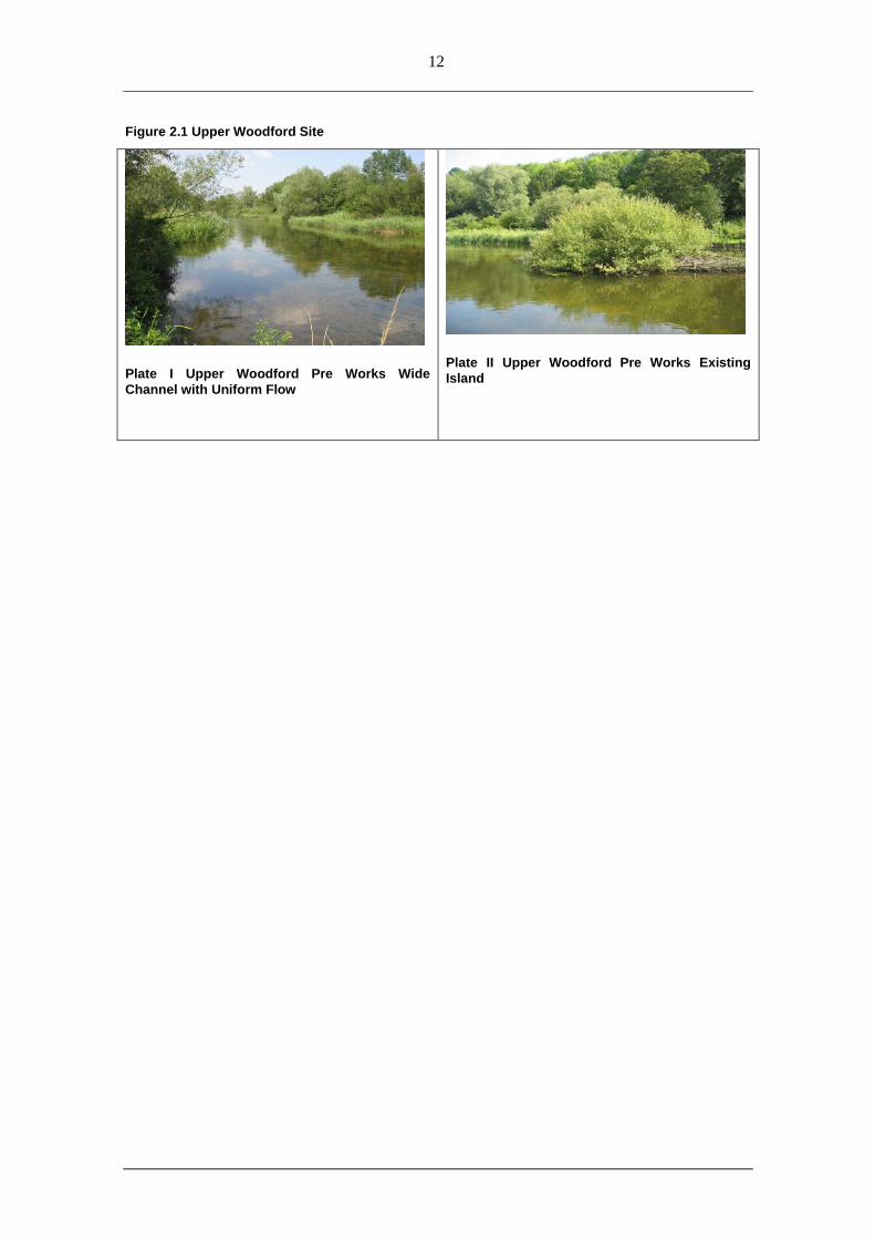
characteristics (see Plate I). Despite the presence of islands in Reach 2 (see Plate II) very little
variation in flow was observed primarily due to the extremely low water levels on the day of the
assessment and sluggish rate of flow caused by the large impoundment downstream. The water
held back by the impoundment was required to maintain water levels for trout stock ponds, a
county wildlife site swamp and wetland habitat close to the river. Thus there was little scope for
altering its management regime. The reach (which incorporates both Reach 2 and Reach 3) was
over wide with no geomorphological features present and negligible flow. The bed substrate
was dominated by gravel with large amounts of silt. The physical characteristics of the reach
were reflected in the ecological community that it was seen to support fish species were present
however the reach was highly exposed with few bankside trees and minimal instream vegetation
to provide shelter or shade. The low diversity of flow will have altered the aquatic invertebrate
community composition found in this reach in comparison to the upstream reach.
The bank vegetation communities are much the same as in Reach 1, however some private
gardens were present on the right bank. The bank cover was typically high (95-100%), and the
11
proportion of marginal vegetation varied considerably from 20-95%. In Reach 2 the average in
channel cover is 40% comprised mainly of Ranunculus; however, in Reach 3 the backwater
effect of the downstream weir prevents any in stream vegetation from growing. As in Reach 1,
this section of the River Avon supports a strong water vole community and the undisturbed
reedbed and willow Carr found on the right bank was likely to provide a good habitat for birds.
The lower section of the reach had a very low gradient, with little variation in flow velocity and
a fine, sediment dominated, uniform bed. Right bank land use was increasingly affected by the
presence of the gardens of residential properties adjoining the river. Large flocks of swans had
periodically grazed the whole reach in the recent past, to the detriment of the submerged aquatic
vegetation.
Over the whole of this downstream section (Reach 4) the geomorphological reach
characteristics were fairly uniform with no sinuosity or geomorphological features of note apart
from some slight variation in bed level. The substrate was dominated by silt with some gravel in
patches. The ecological characteristics of this section was very poor for a chalk stream; this was
primarily seen to be a result of the downstream impoundment.
The bankside vegetation communities were much the same as Reaches 2 and 3, comprising of a
mixture of woodland and grassland with some private gardens on the right bank. The percentage
bank cover and marginal vegetation were both similarly high (varying from 90-100%),
providing a good habitat for water voles which are known to be abundant in this location, a
variety of wildfowl were also seen in this unit on the day of the assessment. The percentages of
in channel vegetation and tree cover were both extremely limited (2-5% and 1% respectively)
resulting in an extremely exposed channel.
2.2 Proposed Restoration Works
The objective of the restoration work is to demonstrate a range of bio-engineering techniques
useful for the narrowing of river channels. The range of techniques will provide a „tool-box‟ that
fishing clubs could carry out themselves. This will help integrate the needs of riparian ecology
with fishery management. The work will demonstrate that instream enhancements can be
installed without excessive erosion at critical locations such as adjacent to the gardens of
riverside properties.
A range of restoration techniques were proposed which included;
• Creation of 5 small mid channel islands
• 60 degreee upstream facing groynes
• „D‟ deflectors
• „V‟ shaped Deflectors
• Brushwood revetment
The use of these techniques at key locations will reduce the cross-sectional area of the channel
in order to promote the development of a sustainable Ranunculus spp. community. The work
will increase sorting of substrate and diversity of the river bed profile and will promote the
development of increased quality and quantity of habitat for Salmo salar, Cottus gobio and
Lampetra planeri.
12
Figure 2.1 Upper Woodford Site
Plate I Upper Woodford Pre Works Wide
Channel with Uniform Flow
Plate II Upper Woodford Pre Works Existing
Island
2
1
3
1
2
1
18
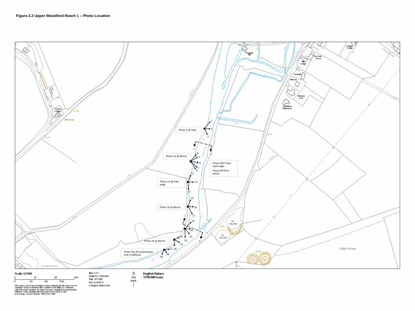
Photo 4 @ Seat
5
6
79
Photo 10 @ Bench
Photo 5/6/7 from
bank edge
Photo 8/9 from
bench11
12
13
Photo 14 @ Path
edge
15
17
16Photo 18 @ Bench
19
22
20
2123
24
2527
2829
Photo 26 @ Bench
Photo 30a @ Downstream
end of deflector
Figure 2.2 Upper Woodford Reach 1 – Photo Location
32
36
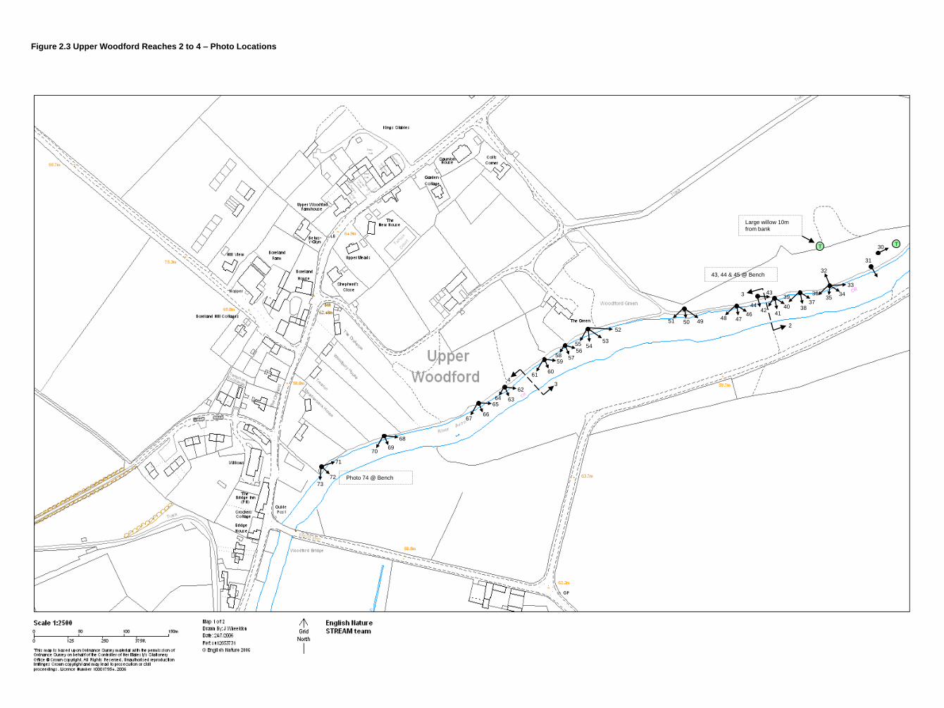
Large willow 10m
from bank
T T30
31
3534
33
2
339
3837
41
4042
43
44
43, 44 & 45 @ Bench
4746
485051 49
52
535455
56
5758
6061
59
34
6364
62
6667
65
6970
68
72
73
71
Photo 74 @ Bench
Figure 2.3 Upper Woodford Reaches 2 to 4 – Photo Locations
15
3. Assessment of Proposed Restoration and Likely Outcomes
The restoration work at Upper Woodford was essentially aimed at reducing the channel width
with deflectors and islands which would increase flows, provide marginal/slow flow areas
which would act as refuges for fry and marginal aquatic invertebrates and remove silt form the
gravel substrate to create potential spawning grounds.
The expected outcomes for Reach 1 included changes in water levels as a result of the
narrowing, island creation and introduction of large woody debris (LWD) into the channel. It
was noted that if water levels are increased too much this could impact on the free flowing
nature of the river.
For the restoration reaches it was thought that the changes that would occur as a result of the
works would include an increased variation in channel width and rate of flow as a result of
changes to the channel planform through the introduction of islands, groynes and „D‟ shaped
deflectors. It was further noted that the effectiveness of the introduction of these features was
entirely dependant upon the level of the downstream impoundment, if the impoundment remains
at the current level the positive benefits of these works were likely to be minimal. Increase in
marginal habitat as a result of channel narrowing was also expected along with a change in
ecological species composition due to changes to the physical characteristics of the channel.
For the reach downstream of the restoration works an increase in siltation as a result of silt
being flushed out of upstream reaches was expected in the short term; however, this was
perceived to be a minor impacts as there is already significant amounts of silt in this reach. It
was also noted that noise disturbance to a quite area during the construction phase was likely to
affect all the reaches.
This pre works assessment highlighted one major concern over the effectiveness of any
restoration works at this site, and that was the backwater effect of the downstream weir. Despite
the introduction of island, groynes and deflectors this restoration project was unlikely to achieve
its objectives unless the impoundment level of the downstream weir were reduced and the
conveyance of water through these reaches returned to a more natural regime. However due to
the reliance on the downstream weir to maintain water levels for trout stock ponds, a county
wildlife site swamp and wetland habitat close to the river there was little scope for altering its
management regime, a factor that was likely to severely impact the effectiveness of the
restoration works at this site.
The methods used to narrow the channel and create flow diversity rely on vegetative growth
colonising the areas between the groynes and within the islands and „D‟ deflectors, the success
of which would depend on the accumulation of sediment in these areas, which would be
effected by whether the restoration works were carried out from the downstream end of the
target reach to the upstream end or vica versa.
The Site visits were carried out, 25th July 2006 (pre project), 16
th October 2006 (during
construction), 18th April 2007 (as built) and 9
th April 2009 (post works). The Reaches (see maps
Figure 2.2 and Figure 2.3) can be summarised as
• Reach 1 - upstream of restoration reaches
16
• Reach 2 - restoration reach
• Reach 3 - restoration reach
• Reach 4 - impounded sections downstream of restoration reach
Hatch operation field trials
Trials have been undertaken to investigate the operation of Heale House Hatches and their
influence on water levels at the restoration site. The aim of the trials was to:
• roughly determine the limit of influence of hatches in different flow conditions and
at different settings
• inform development of hatch operating protocol (HOP), which aims to allows
Heale gardens and trout stews to have enough water, whilst reducing impoundment
upstream (n/b may require modification of off take into the stews).
The general approach to the water level trials was as follows;
• Install temporary fixed and marked posts between hatches and upstream or
restoration works.
• Day 1: start with hatches in a “normal” position i.e. high level of impoundment,
hatches fairly closed (take photo/notes to record setting). Allow levels to settle
over night.
• Day 2: Check hatches are still set in same way then record water levels and exact
time at fixed points along the river.
• Open hatches as far as possible without drying trout stew out
• Repeat water level readings.
• Repeat trials over the summer in order to determine influence of hatches in a range
of flows.
In order to compare water levels over a 2 day period, river flow needed to be constant, so trials
could only be carried out when there was little rain in the preceding week. The recorded
changes in water level will not be exact but will give an indication of how far up the river the
hatches have an influence.
17
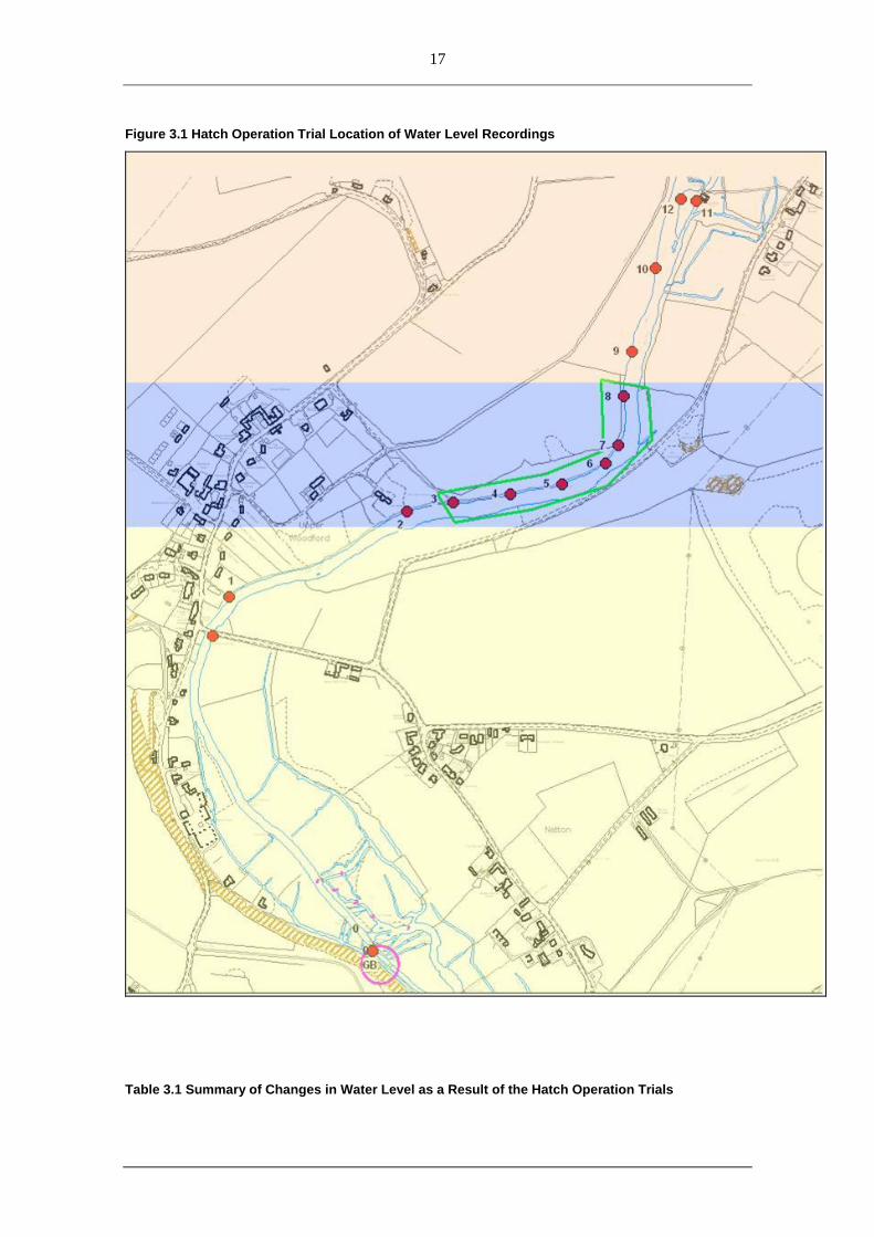
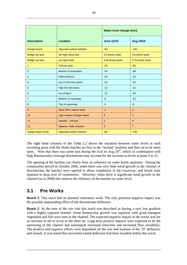
Figure 3.1 Hatch Operation Trial Location of Water Level Recordings
Table 3.1 Summary of Changes in Water Level as a Result of the Hatch Operation Trials
18
Description Location
Water level change (mm)
June 12/13 Aug 23/24
Gauge board Opposite turbine hatches -60 -140
Bridge d/s face d/s right hand side 0.5 bricks lower 0.8 bricks lower
Bridge u/s face u/s right hand 0.65 bricks lower 0.75 bricks lower
1 Pub car park -31 -60
2 Bottom of restoration -24 -38
3 Path entrance -20 -32
4 u/s of 2nd new island -18 -25
5 Opp 3rd old island -12 -21
6 u/s of big D -12 -10
7 Bottom of causeway -8 -10
8 Top of causeway -5 -8
9 Seat 100 m above work -1 0
10 Opp. bottom of large island 0 2
11 Adeane - mill leat 1 4
12 Adeane- main channel 0 7
Gauge board (end) Opposite turbine hatches -60 -140
The right hand columns of the Table 2.2 shows the variation between water levels at each
recording point with the Heale hatches set first in the “normal “position and then set to be more
open. Note that there was some rain during the trial on Aug 24th, which in combination with
high Raununculus coverage downstream may account for the increase in levels at posts 9 to 12.
The opening of the hatches can clearly have an influence on water levels upstream. During the
construction period in October 2006, when there was very little weed growth in the channel or
downstream, the hatches were opened to allow completion of the causeway, and levels were
reported to drop over 10 centimetres. However, when there is significant weed growth in the
channel (as in 2008) this reduces the influence of the hatches on water level.
3.1 Pre Works
Reach 1: This reach had no planned restoration work. The only potential negative impact was
the possible impounding effect of the downstream deflectors.
Reach 2: At the time of the site visit this reach was described as having a very low gradient
with a highly exposed channel. Some Ranunculus growth was reported, with good emergent
vegetation and fish were seen in the channel. The expected negative impact of the works was for
an increase in silt to occur in the short ter. Long term positive impacts were expected to be the
narrowing of the channel and subsequent increased velocities and increased flow variability.
The positive and negative effects were dependent on the size and location of the „D‟ deflectors
and islands. It was noted that successful island deflectors had been installed within this reach.
19
Reach 3: This reach was described as being very over-widenend with little instream variation.
Silt and gravel was observed on the channel bed and flows were sluggish. It was recognised that
the success or otherwise of the works in this reach were largely dependent on the modification
to the hatch operating agreement. The introduction to this section (Section 3) lays out the
assessment of the hatch operation trials and confirms that the hatches have a marked influence
on water levels in this reach except when there is significant weed growth. It was flagged up
that there was a need to revisit the objectives and rational for the works before they were
completed. The long term positive effects of the works were entirely dependent on the hatch
operation, without the ability to lower the water levels the restoration works would potentially
be little influence on the hydro-morphology of the channel; however, marginal vegetation may
increase so there could be a minor positive impact. No negative impacts were expected.
Reach 4: This reach was characterised by a wide deep silty channel and was significantly
affected by the impoundment influences of the downstream weir. No positive impacts were
expected and the only possible negative impact was siltation, but this would only be minor since
there was already so much silt in this reach.
3.2 During Construction
Reach 1: No positive or negative effects were observed. The full effect of the works could not
be commented on as only the posts of the deflectors had been installed.
Reach 2: Newly installed posts were collecting weeds. No positive effects were observed.
There was disruption to the bankside and instream habitat which was perceived as a minor
negative impact in the short term. The full effect of the works could not be commented on as
only the posts of the deflectors had been installed.
Reach 3: This reach had identical issues and impacts as Reach 2.
Reach 4: No positive or negative effects were observed. The full effect of the works could not
be commented on as only the posts of the deflectors had been installed.
3.3 As Built
Reach 1: No negative impacts were observed. There was a good rate of flow and no
impounding as a result of the works was occurring.
Reach 2: The mid channel islands and „D‟ deflectors had created flow variability. Deposition of
fine silt and organic material was occurring in the brushwood of the deflectors. However the
channel is still too wide. Lots of natural vegetation has taken place in the structures.
Reach 3: The same impacts as Reach 2.
Reach 4: No positive or negative impacts were observed.
20
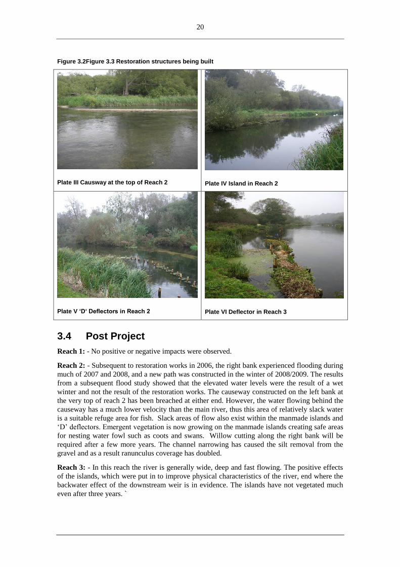
Figure 3.2Figure 3.3 Restoration structures being built
Plate III Causway at the top of Reach 2
Plate IV Island in Reach 2
Plate V ‘D‘ Deflectors in Reach 2
Plate VI Deflector in Reach 3
3.4 Post Project
Reach 1: - No positive or negative impacts were observed.
Reach 2: - Subsequent to restoration works in 2006, the right bank experienced flooding during
much of 2007 and 2008, and a new path was constructed in the winter of 2008/2009. The results
from a subsequent flood study showed that the elevated water levels were the result of a wet
winter and not the result of the restoration works. The causeway constructed on the left bank at
the very top of reach 2 has been breached at either end. However, the water flowing behind the
causeway has a much lower velocity than the main river, thus this area of relatively slack water
is a suitable refuge area for fish. Slack areas of flow also exist within the manmade islands and
„D‟ deflectors. Emergent vegetation is now growing on the manmade islands creating safe areas
for nesting water fowl such as coots and swans. Willow cutting along the right bank will be
required after a few more years. The channel narrowing has caused the silt removal from the
gravel and as a result ranunculus coverage has doubled.
Reach 3: - In this reach the river is generally wide, deep and fast flowing. The positive effects
of the islands, which were put in to improve physical characteristics of the river, end where the
backwater effect of the downstream weir is in evidence. The islands have not vegetated much
even after three years. `

21
Reach 4: - No positive or negative impacts were observed.
22
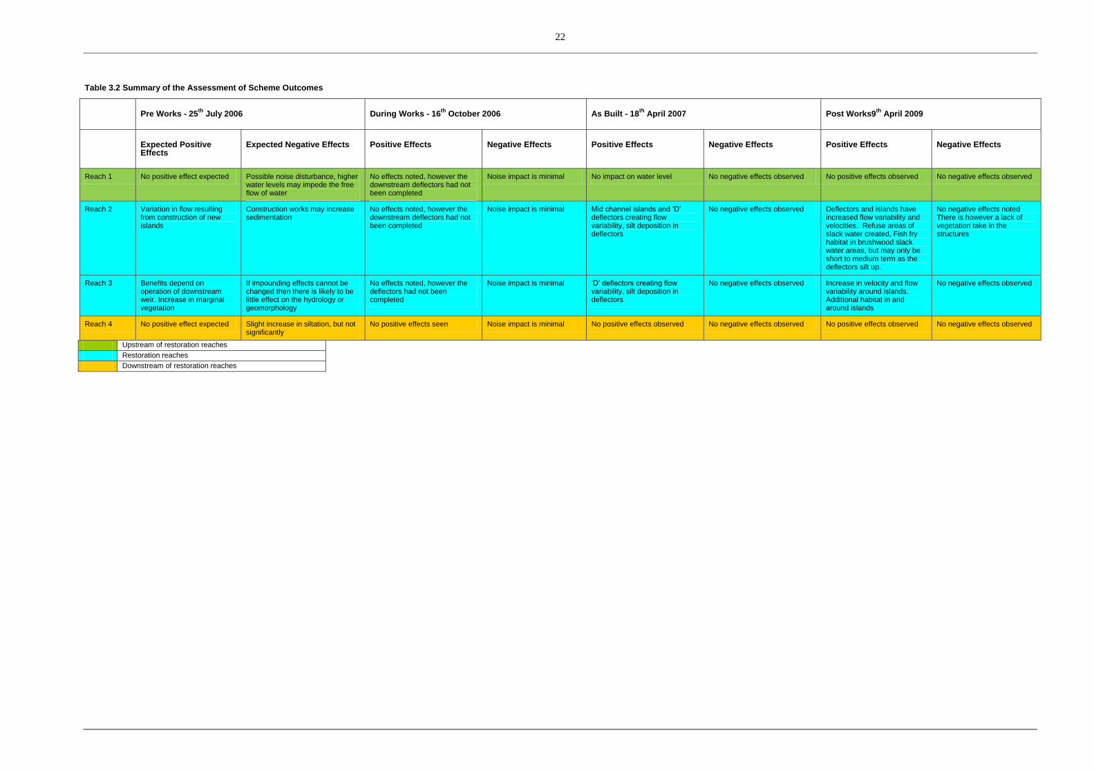
Table 3.2 Summary of the Assessment of Scheme Outcomes
Pre Works - 25
th July 2006 During Works - 16
th October 2006 As Built - 18
th April 2007 Post Works9
th April 2009
Expected Positive Effects
Expected Negative Effects Positive Effects Negative Effects Positive Effects Negative Effects Positive Effects Negative Effects
Reach 1 No positive effect expected Possible noise disturbance, higher water levels may impede the free flow of water
No effects noted, however the downstream deflectors had not been completed
Noise impact is minimal No impact on water level No negative effects observed No positive effects observed No negative effects observed
Reach 2 Variation in flow resulting from construction of new islands
Construction works may increase sedimentation
No effects noted, however the downstream deflectors had not been completed
Noise impact is minimal Mid channel islands and ‘D’ deflectors creating flow variability, silt deposition in deflectors
No negative effects observed Deflectors and islands have increased flow variability and velocities. Refuse areas of slack water created, Fish fry habitat in brushwood slack water areas, but may only be short to medium term as the deflectors silt up.
No negative effects noted There is however a lack of vegetation take in the structures
Reach 3 Benefits depend on operation of downstream weir. Increase in marginal vegetation
If impounding effects cannot be changed then there is likely to be little effect on the hydrology or geomorphology
No effects noted, however the deflectors had not been completed
Noise impact is minimal ‘D’ deflectors creating flow variability, silt deposition in deflectors
No negative effects observed Increase in velocity and flow variability around islands. Additional habitat in and around islands
No negative effects observed
Reach 4 No positive effect expected Slight increase in siltation, but not significantly
No positive effects seen Noise impact is minimal No positive effects observed No negative effects observed No positive effects observed No negative effects observed
Upstream of restoration reaches
Restoration reaches
Downstream of restoration reaches
23
3.5 Reasons for Changes from Original Planned Works
Table 3.3 Changes form Original Planned Works
Works proposed in bid Alternative (constructed) Reason for change
60 degree groynes Not constructed Section too impounded
‘D’ Deflectors penetrating well into the channel
Two ‘D’ deflectors subsequently reduced in size
To reduce perceived impact on water levels on adjacent bank
No changes to Right Bank height Repairs and subsequent highering of Right Bank
Inundation of Right Bank due to high water levels
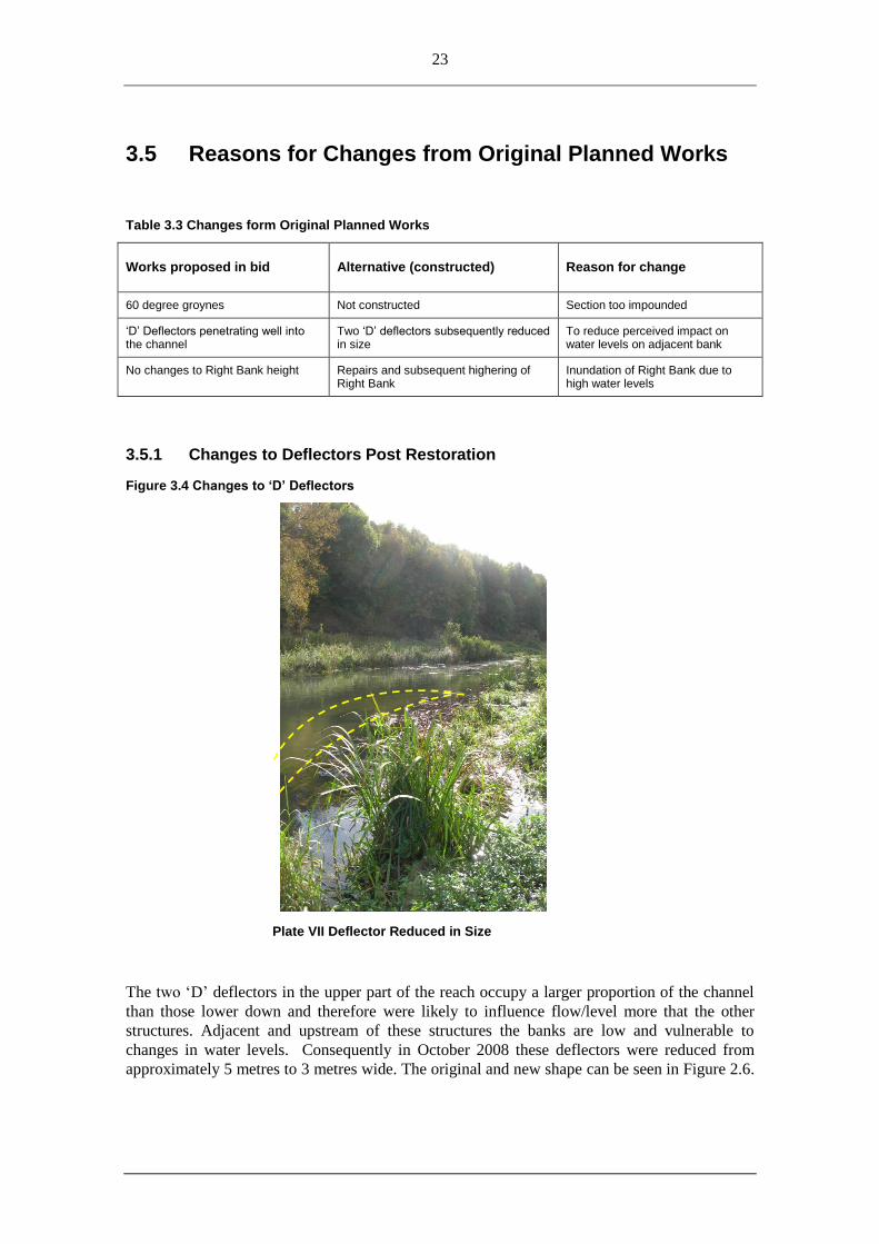
3.5.1 Changes to Deflectors Post Restoration
Figure 3.4 Changes to ‘D’ Deflectors
Plate VII Deflector Reduced in Size
The two „D‟ deflectors in the upper part of the reach occupy a larger proportion of the channel
than those lower down and therefore were likely to influence flow/level more that the other
structures. Adjacent and upstream of these structures the banks are low and vulnerable to
changes in water levels. Consequently in October 2008 these deflectors were reduced from
approximately 5 metres to 3 metres wide. The original and new shape can be seen in Figure 2.6.
24
Reducing the deflectors is reported to have reduced water levels immediately upstream by about
50mm (see Plate VII).
3.5.2 Bank Works Post Restoration
River restoration work was completed on the River Avon at the Broads in November 2006 as
part of the STREAM project. Subsequent to the completion of the works, two of the three
wettest summers in 28 years were experienced, combined with very high weed growth around
the catchment. Bank inundation has occurred at a number of locations in the Upper Avon
catchment, including Upper Woodford, which are normally reasonably dry.
The combination of the wet summers, high weed growth and restoration work resulted in parts
of the right bank at Upper Woodford being inundated with water for much of 2007 and 2008
(including areas above and below the works), preventing safe access to the river bank.
Prolonged water logging and flow over parts of the river bank have resulted in holes developing
in the main fishing path, and the return path becoming boggy. As a result, approximately 200
metres of the fishery are unsafe to access. As a temporary solution, areas of bank were repaired
using heather bales to create ensure safe access, however a more permanent approach was
required. After a site meeting held on December 10th 2009 to consider an acceptable technical
solution which included;
• Install approximately 200 metres of angler access path. Gaps in the access path to
be created at 5 points, to allow free flow of water between the river and floodplain
• Structure to be approximately 1.2 metres wide, resulting in mown access of 0.8
metres wide, final height approximately 0.1 m above current (wet and eroded) bank
level
• 75% of the total length of structure to be wooden posts, brushwood base overlain
with coir mat and topped with local chalk
• 25% of the total length of structure to be wooden posts, coir mat and geotextile
liner, topped with local chalk
• Path to follow contours of river bank, retaining approximately 1 metre wide
vegetated margin between path and bank
• Small “spits” from path to bank to be created where the natural contours mean the
path is set back from the edge of the water too far to fish.
• Connections to be made between angler access and the existing return path. Return
path to be patched in places where very waterlogged and eroded.
The work was implemented in February-April 2009.
25
4. Pre and Post Project Monitoring
Royal Haskoning were commissioned by Natural England to record physical and biological
conditions pre and post restoration at each of the sites. The surveys were designed to document
physical changes that occurred as a result of the restoration works and provide a baseline for
further monitoring. The monitoring included;
• Reach-scale mapping using Physical Biotope Mapping and River Corridor Survey;
• Channel cross section surveys;
• Macrophyte surveys, and;
• Fisheries surveys.
Monitoring at each site was within the restored reach and at a control site some distance away
from the restoration site.
For the Upper Woodford restoration works the control site was at Durnford Mill just upstream
of Reach 1 of the restoration site. The repeat photography comparing the control site and the
restoration site showed that the flows and water levels were much greater in 2008 after the
works had occurred compared with the pre works photographs taken in 2006. As discussed
earlier, higher flows were not the result of the restoration works rather they were the result of
increased weed growth and high rainfall.
For the control site despite there being no intervention within this reach between 2006 (pre
scheme) and 2008 (post scheme), key differences were observed between the two surveys
undertaken. The majority of these differences were related to higher discharges and water
levels experienced both during the survey and throughout 2007 and 2008.
As a result of increased water levels, a glide physical biotope was observed throughout the
reach in 2008, rather than the alternating run and glide sequence observed in 2006. Minor cross-
sectional changes have occurred in association with increased marginal vegetation growth along the
channel banks, and undermining of channel narrowing measures in the channel. Bed elevation
has decreased at each cross section probably due to increased bed scour during high flows.
The dominant substrate changed to gravel rather than pebble sized material and there were
more areas of silt. This may be due to reduced armouring resulting from increased flow
depth and trapping of finer material by in-channel vegetation. Greater coverage of
Ranunculus pencilatus spp. pseudofluitans was observed throughout the reach.
For the restoration site works were undertaken within between 2006 and 2008 and key
differences were observed between the two surveys undertaken. However, the majority of these
differences reflect similar differences observed at the control site upstream and are likely to
be related to higher discharges and water levels experienced both during the survey and
throughout 2007 and 2008. Due to the drastically different flow conditions, it is not possible
to relate specific differences, other than the physical interventions themselves, to the restoration
works.
As a result of increased water levels, a glide physical biotope was observed throughout the
reach in 2008, rather than the alternating run and glide sequence observed in 2006. The
influence of impoundment was also less pronounced. Cross-sectional changes have occurred in
26
association with both implementation of the restoration works and increased marginal
vegetation growth along the channel banks. Cross sectional area of flow and flow velocities
were significantly greater in 2008 as a result of higher discharges.
The dominant substrate in the centre of the channel in 2008 at the most downstream cross-section
was gravel in 2008, rather than silt. This is likely to reflect increased flow velocities. Localised
increases in silt were observed in the channel, particularly at the channel margins. This is likely
to be attributable to the lower flow velocities at the margins, and trapping of sediment by
vegetation and marginal structures.
Greater coverage of brook water-crowfoot was observed throughout this reach as well as at
the control site. The increased cover of this key interest species is therefore unlikely to be
directly related to the restoration works themselves. As in 2006, coverage of brook water-
crowfoot generally declines with distance downstream. This trend is likely to be related to
increasing flow depth, decreasing flow velocities and increasing siltation.
Greater numbers of salmon, trout and grayling but fewer bullhead, brook lamprey and
minnows were caught in 2008 compared with 2006. This is likely to reflect changes in flow
velocities and water depth, making physical habitat conditions more suitable for rheophilic fish
species and those not requiring shallow waters (minnows). Trout predation is also a key
threat to bullhead, though other predators include pike and eel.
27
5. Assessment of Methods Used
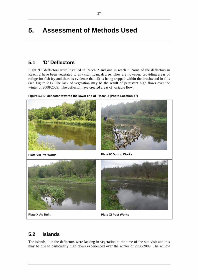
5.1 ‘D’ Deflectors
Eight „D‟ deflectors were installed in Reach 2 and one in reach 3. None of the deflectors in
Reach 2 have been vegetated to any significant degree. They are however, providing areas of
refuge for fish fry and there is evidence that silt is being trapped within the brushwood in-fills
(see Figure 2.1). The lack of vegetation may be the result of persistent high flows over the
winter of 2008/2009. The deflector have created areas of variable flow.
Figure 5.1‘D’ deflector towards the lower end of Reach 2 (Photo Location 37)
Plate VIII Pre Works
Plate IX During Works
Plate X As Built
Plate XI Post Works
5.2 Islands
The islands, like the deflectors were lacking in vegetation at the time of the site visit and this
may be due to particularly high flows experienced over the winter of 2008/2009. The willow
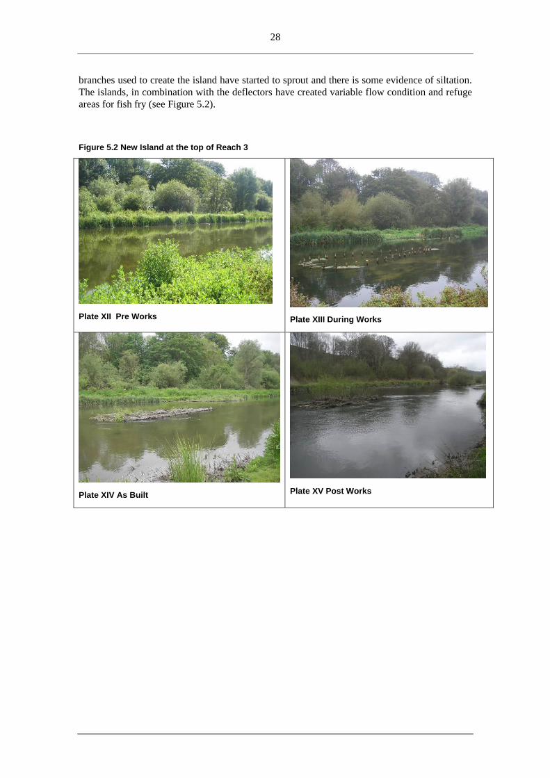
28
branches used to create the island have started to sprout and there is some evidence of siltation.
The islands, in combination with the deflectors have created variable flow condition and refuge
areas for fish fry (see Figure 5.2).
Figure 5.2 New Island at the top of Reach 3
Plate XII Pre Works
Plate XIII During Works
Plate XIV As Built
Plate XV Post Works
29
5.3 Causeway
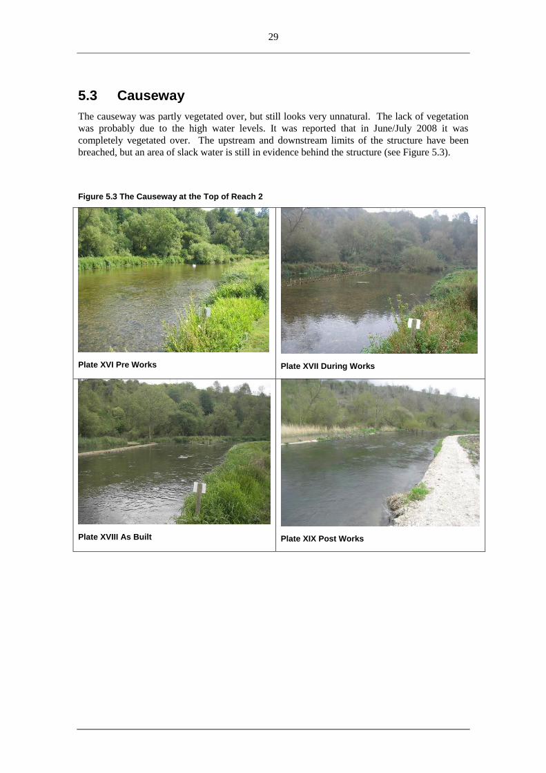
The causeway was partly vegetated over, but still looks very unnatural. The lack of vegetation
was probably due to the high water levels. It was reported that in June/July 2008 it was
completely vegetated over. The upstream and downstream limits of the structure have been
breached, but an area of slack water is still in evidence behind the structure (see Figure 5.3).
Figure 5.3 The Causeway at the Top of Reach 2
Plate XVI Pre Works
Plate XVII During Works
Plate XVIII As Built
Plate XIX Post Works
30
Figure 5.4 Restoration Features
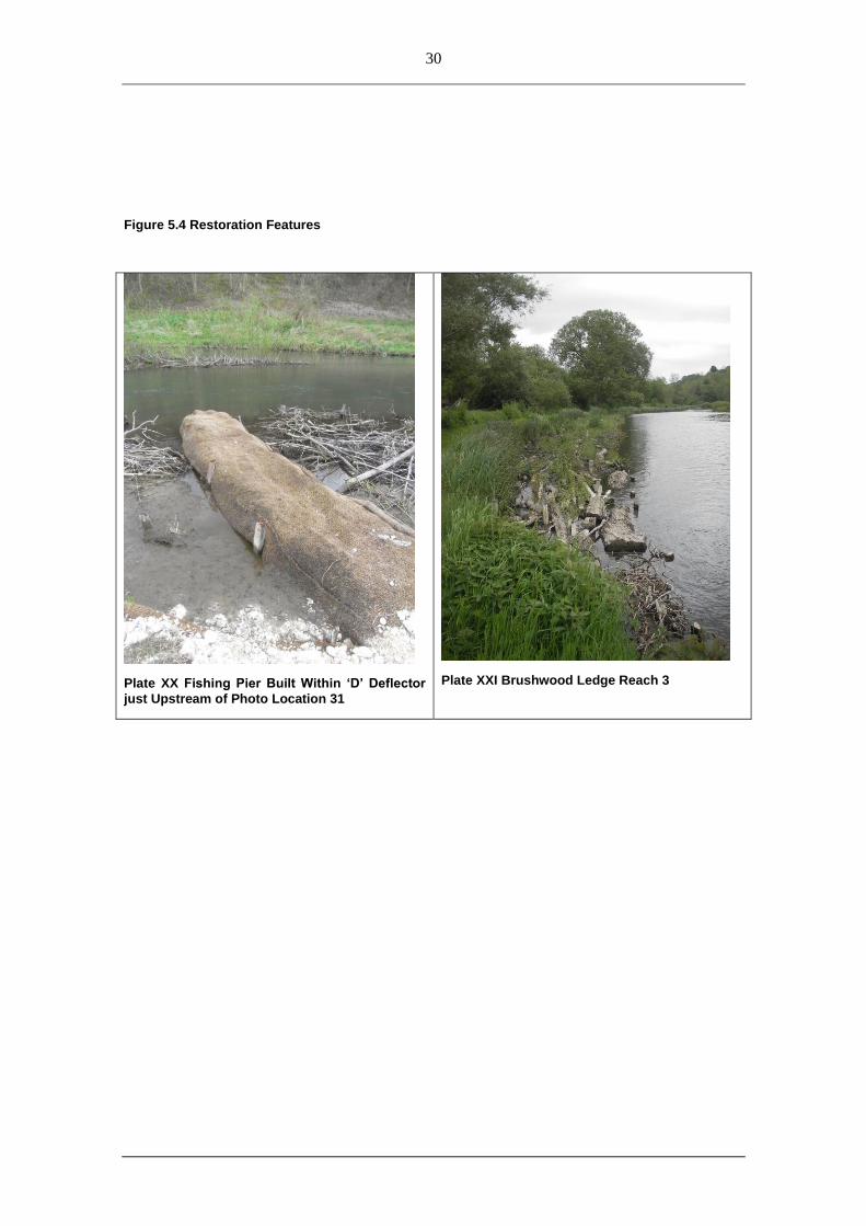
Plate XX Fishing Pier Built Within ‘D’ Deflector
just Upstream of Photo Location 31
Plate XXI Brushwood Ledge Reach 3
31
6. Discussion and Recommendations
6.1 Discussion
The upstream causeway has narrowed the channel from its significantly over-wide state. The
thin strip of made land now separates an area of slow flowing to still water (beneficial for fry
and amocetes). The lower edge of the causeway is consistently over-topping due to the raise
water levels of the past two years and some minor erosion of the chalk structure is occurring.
This could continue to develop into a breach and may need repair to prevent the ponded section
from flowing. As marginal and submerged vegetation grows within this area, the flow path
through the ponded section will become more occluded.
The islands act to split flows, add woody material to the river (as a habitat for invertebrates and
fry) and this in turn will accrete silt and provide a good growing medium for further vegetation
growth. The establishment of tall willows on the islands may need to be managed by the river
keeper, or they could be left to establish and provide much needed shade and cooling to river in
summer months, becoming more resilient to climatic warming. Island existed along the reach
before these works and the benefit of these helped to determine the need for additional ones.
The „D‟ shape brushwood deflectors are similar to the islands in their make-up and intended
purpose. They have vegetated well (prior to the exceptionally high water levels) with a mix of
marginal and emergent plants and shrubby willows. The deflectors still have shallow areas of
open water within them providing fry habitat. The marginal brushwood ledge in Reach 3 also
provides additional edge habitat for smaller fish and lamprey young (see Plate XX).
The restoration works will have benefited several of the SAC species. Greater flow diversity
will have been created for salmonids. Silty margins which are developing in the deflectors will
provide for habitat for Lamprey amocetes and the shallow margins will provide refuge areas for
salmonid fry. By increasing flow velocity over a narrowed width, this will aid the mobilisation
and self cleaning of silt from spawning gravels.
6.2 Lessons Learnt
For this site potential for major restoration was always limited by the impoundment of the weir
downstream. There removal of the weir, or modification of operating protocol, would have a
considerable benefit for all the upstream reaches.
The initial design specified additional deflectors at the lower end of the site (Reach 4) however
it became apparent on the initial pre-works assessment visit that these structures would have
very little impact if implemented as flow velocities were so low. Subsequently the hatch
operating protocol has been proposed which should reduce the adverse impact of the
impoundment.
An obvious lesson learnt from this project is the issue of designing works based on only a short
term data set. The designs were carried out based on preceding years flow records being below
long term average. Subsequent to the restoration work being undertaken flows switched to
being above long term average. This, coupled with the successful increase in Ranunculus
growth, raised water levels significantly. These two elements should be borne in mind at other

32
sites, especially on chalk streams where wet.dry years and summer submerged macrophyte
growth can have a large effect on water height.
Landowner and angling club concerns may seem minor in relation to the overall goal, however,
as the custodians of the river thereafter these groups need to be informed, listened to and buy
into the process of river restoration from the very early discussions of what „their‟ river should
look like. Otherwise they are able to severely compromise a budget if compensatory works are
required, and longer term may even be tempted to undo the work achieved if it is perceived to
be problematic and not what they expected.
6.3 Recommendations
The qualitative monitoring cannot conclude success or failure as the timeframe is too short.
This assessment shows that the changes to the river are only just beginning to be visible, and in
some case will take many more years to reach the desired end result. The STREAM project has
aimed to work with natural riverine processes, altering the channels in small ways rather than
large scale engineering works (which are more costly and increase ecological disturbance). This
approach is going to require more „vision‟ in terms of immediate works versus long term results.
As with Seven Hatches the implementation of a suitable hatch operating protocol should ideally
occur before design of any restoration works such that the altered conditions are then used as a
baseline for the planned work. This was not possible here as the operating protocol was
developed in parallel with the demonstration projects
33
7. References
Estimating costs of delivering the river restoration element of the SSSI PSA target, EA
2008 Natural England, Physical and biological monitoring of STREAM restoration projects – Year
Three Report, April 2009.
Natural England, STREAM 4th Annual Report, Dec 2008
Natural England, River Avon SAC STREAM Interim Report, June 2008.
Wessex Water, Short term effects on aquatic macroinvertebrates, 2008

34
Appendix A River Restoration Rapid Assessment Forms
the RIVER RESTORATION CENTRE
RRC Project Assessment Form©
July 2006, Janes, Mant and Fellick. Page 1 of 4
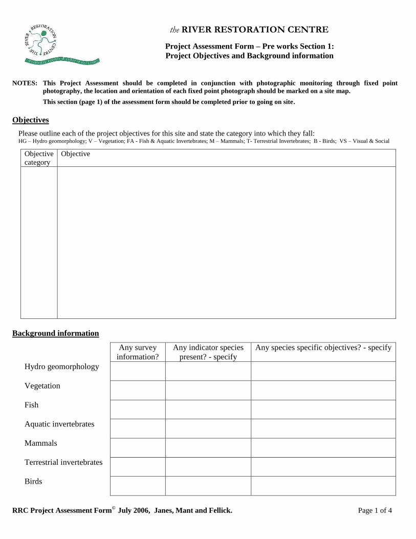
Project Assessment Form – Pre works Section 1:
Project Objectives and Background information
NOTES: This Project Assessment should be completed in conjunction with photographic monitoring through fixed point
photography, the location and orientation of each fixed point photograph should be marked on a site map.
This section (page 1) of the assessment form should be completed prior to going on site.
Objectives
Please outline each of the project objectives for this site and state the category into which they fall: HG – Hydro geomorphology; V – Vegetation; FA - Fish & Aquatic Invertebrates; M – Mammals; T- Terrestrial Invertebrates; B - Birds; VS – Visual & Social
Objective
category
Objective
Background information
Any survey
information?
Any indicator species
present? - specify
Any species specific objectives? - specify
Hydro geomorphology
Vegetation
Fish
Aquatic invertebrates
Mammals
Terrestrial invertebrates
Birds

the RIVER RESTORATION CENTRE
RRC Project Assessment Form©
July 2006, Janes, Mant and Fellick. Page 2 of 4
Project Assessment Form – Pre works Section 2:
Unit description, reach, vegetation and landuse characteristics1
NOTE: An assessment needs to be completed for each ‘assessment unit’ - identified according to geomorphological features, changes
in riparian landuse, vegetation & floodplain characteristics. The location of each unit must be marked on a site map.
Date: Surveyor: GPS point:
River name: Assessment Unit: Weather conditions:
Unit description
Reach Characteristics
Code: LB - Left Bank; RB-Right Bank; Cl – Clay; H-High; M-Medium; L-Low; NF-No perceivable Flow; Y-Yes; N-No
Bankful width (m) Bankful depth (m) Bank slope range (o) LB RB
Av. riffle water depth (m) Av. pool water depth (m) Av. water depth (m) - no pool/riffle sequence
Bank Material (LB) – D= dominant, tick others: Cobble Gravel Cl Sand Silt Artificial
Bank Material (RB) – D= dominant, tick others: Cobble Gravel Cl Sand Silt Artificial
Bed Material– ‘D’= dominant, tick others: Cobble Gravel Cl Sand Silt Artificial
If there is any artificial bank or bed material please state the % and provide brief details:
% LB % RB % Bed Details:
Has it got any geomorphological features? Please note, and estimate spacing for pool / riffle sequence.
Sinuosity (H/M/L) Bars (Y/N) Bed variation (Y/N) Width variation (Y/N)
Deposition (Y/N) Bank Erosion (Y/N) Pools / riffles (Y/N) Approx. spacing (m):
Is there any variation in flow? (Y/N) What is the average stream power? (H/M/L/NF)
Please sketch the typical reach X-
section, labelling LB and RB.
Include main features, floodplain
characteristics & flow conditions.
Vegetation
Av. in-channel cover (%): Av. Marginal cover (%): Av. Bank cover (%): LB RB
Av. tree cover (%): LB RB Is the vegetation typical / native to the river? (Y/N):
Are there any invasive species present (Y/N) Specify……………………………………………………………
Landuse
Please tick main type of landuse – for ‘Farmland’ please delete arable or grazing as appropriate LB RB LB RB LB RB LB RB
Urban Industrial Parkland Farmland: arable/grazing
Private garden Wetland Woodland Other………………
1‘Reach Characteristics’, ‘Vegetation’ & ‘Landuse’ have been adapted from ‘Geomorphological Sensitivity Assessment Sheet’, Detailed Catchment Baseline Review, Environment Agency & University of Southampton, 2000.
the RIVER RESTORATION CENTRE
RRC Project Assessment Form©
July 2006, Janes, Mant and Fellick. Page 3 of 4
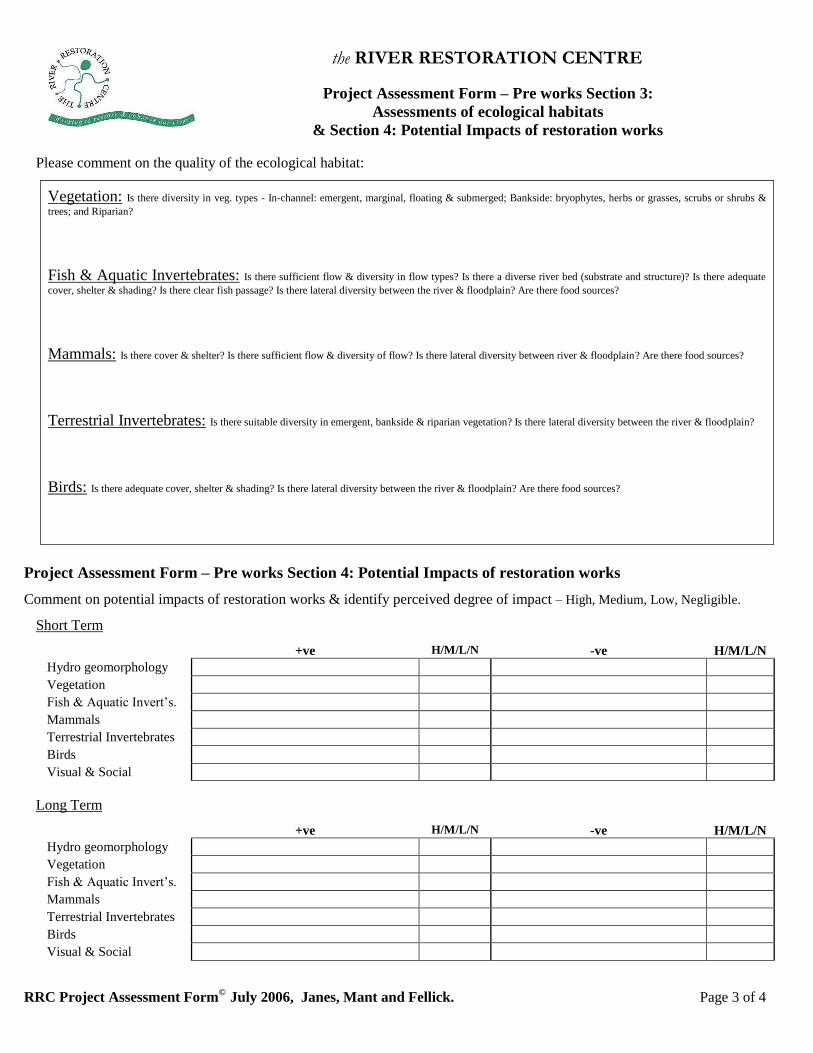
Project Assessment Form – Pre works Section 3:
Assessments of ecological habitats
& Section 4: Potential Impacts of restoration works
Please comment on the quality of the ecological habitat:
Vegetation: Is there diversity in veg. types - In-channel: emergent, marginal, floating & submerged; Bankside: bryophytes, herbs or grasses, scrubs or shrubs &
trees; and Riparian?
Fish & Aquatic Invertebrates: Is there sufficient flow & diversity in flow types? Is there a diverse river bed (substrate and structure)? Is there adequate
cover, shelter & shading? Is there clear fish passage? Is there lateral diversity between the river & floodplain? Are there food sources?
Mammals: Is there cover & shelter? Is there sufficient flow & diversity of flow? Is there lateral diversity between river & floodplain? Are there food sources?
Terrestrial Invertebrates: Is there suitable diversity in emergent, bankside & riparian vegetation? Is there lateral diversity between the river & floodplain?
Birds: Is there adequate cover, shelter & shading? Is there lateral diversity between the river & floodplain? Are there food sources?
Project Assessment Form – Pre works Section 4: Potential Impacts of restoration works
Comment on potential impacts of restoration works & identify perceived degree of impact – High, Medium, Low, Negligible.
Short Term
+ve H/M/L/N -ve H/M/L/N
Hydro geomorphology
Vegetation
Fish & Aquatic Invert’s.
Mammals
Terrestrial Invertebrates
Birds
Visual & Social
Long Term
+ve H/M/L/N -ve H/M/L/N
Hydro geomorphology
Vegetation
Fish & Aquatic Invert’s.
Mammals
Terrestrial Invertebrates
Birds
Visual & Social

the RIVER RESTORATION CENTRE
RRC Project Assessment Form©
July 2006, Janes, Mant and Fellick. Page 4 of 4
Additional notes:
the RIVER RESTORATION CENTRE
RRC Project Assessment Form©
July 2006, Janes, Mant and Fellick. Page 1 of 4
Project Assessment Form – During construction Section 1:
Contractor’s information, Budget, Site plans and Summary of Predicted Impacts
NOTES: This Project Assessment should be completed in conjunction with photographic monitoring through fixed point
photography, the location and orientation of each fixed point photograph should match those taken as part of the ‘Pre
works assessment’. Any additional fixed point photographs considered to be necessary should be marked on a site map.
This section (page 1) of the assessment form should be completed prior to going on site.
Contractor
Company name Name of Foreman:
Contact details:
Budget
What is the budget for this project?
Technical site plans
Have sites plans been supplied? (Y/N)
Any other technical specification details:
Summary of Predicted Impacts (from ‘Pre works’ assessment)
Short Term
+ve H/M/L/N -ve H/M/L/N
Hydro geomorphology
Vegetation
Fish & Aquatic Invert’s.
Mammals
Terrestrial Invertebrates
Birds
Visual & Social
Long Term
+ve H/M/L/N -ve H/M/L/N
Hydro geomorphology
Vegetation
Fish & Aquatic Invert’s.
Mammals
Terrestrial Invertebrates
Birds
Visual & Social
the RIVER RESTORATION CENTRE
RRC Project Assessment Form©
July 2006, Janes, Mant and Fellick. Page 2 of 4
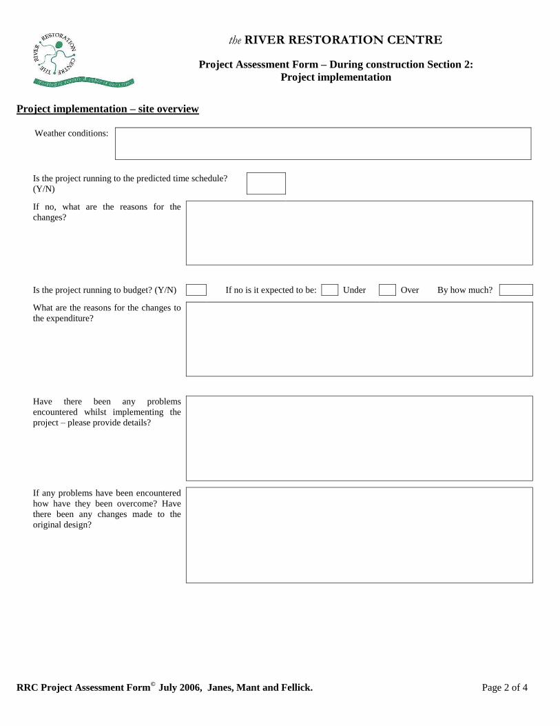
Project Assessment Form – During construction Section 2:
Project implementation
Project implementation – site overview
Weather conditions:
Is the project running to the predicted time schedule?
(Y/N)
If no, what are the reasons for the
changes?
Is the project running to budget? (Y/N) If no is it expected to be: Under Over By how much?
What are the reasons for the changes to
the expenditure?
Have there been any problems
encountered whilst implementing the
project – please provide details?
If any problems have been encountered
how have they been overcome? Have
there been any changes made to the
original design?
the RIVER RESTORATION CENTRE
RRC Project Assessment Form©
July 2006, Janes, Mant and Fellick. Page 3 of 4
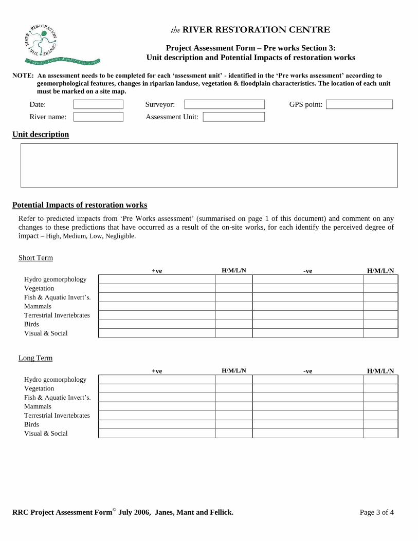
Project Assessment Form – Pre works Section 3:
Unit description and Potential Impacts of restoration works
NOTE: An assessment needs to be completed for each ‘assessment unit’ - identified in the ‘Pre works assessment’ according to
geomorphological features, changes in riparian landuse, vegetation & floodplain characteristics. The location of each unit
must be marked on a site map.
Date: Surveyor: GPS point:
River name: Assessment Unit:
Unit description
Potential Impacts of restoration works
Refer to predicted impacts from ‘Pre Works assessment’ (summarised on page 1 of this document) and comment on any
changes to these predictions that have occurred as a result of the on-site works, for each identify the perceived degree of
impact – High, Medium, Low, Negligible.
Short Term
+ve H/M/L/N -ve H/M/L/N
Hydro geomorphology
Vegetation
Fish & Aquatic Invert’s.
Mammals
Terrestrial Invertebrates
Birds
Visual & Social
Long Term
+ve H/M/L/N -ve H/M/L/N
Hydro geomorphology
Vegetation
Fish & Aquatic Invert’s.
Mammals
Terrestrial Invertebrates
Birds
Visual & Social

the RIVER RESTORATION CENTRE
RRC Project Assessment Form©
July 2006, Janes, Mant and Fellick. Page 4 of 4
Additional notes:
the RIVER RESTORATION CENTRE
RRC Project Assessment Form©
July 2006, Janes, Mant and Fellick. Page 1 of 8
Project Assessment Form1 – Post works section 1:
Basic Project details, Project Objectives, Background information and
Inventory of River Restoration Techniques used
NOTES: This section (pages 1 and 2) of the assessment form should be completed prior to going on site.
Basic Project details
Project name:
Start date: Finish date: Length (km):
Catchment type: Urban / Rural, Upland / Lowland (delete as applicable) Catchment Geology:
Objectives
Please outline each of the project objectives for this site and state the category into which they fall: HG – Hydro geomorphology; V – Vegetation; FA - Fish & Aquatic Invertebrates; M – Mammals; T- Terrestrial Invertebrates; B - Birds; VS – Visual & Social
Objective
category
Objective
Background: Pre and post project information
Any survey information?
(Yes/No)
Any indicator species
present? - specify
Any fixed point
photography? (Yes/No)
Pre Post Pre Post Pre Post
Hydro geomorphology
Vegetation
Fish
Aquatic invertebrates
Mammals
Terrestrial invertebrates
Birds
1 Sections 1, 2 and 4 of this Project Assessment form were adapted from L. de Smith, Post-River Restoration Assessment (PRRA), The development of the 'post river
restoration assessment' for evaluating river restoration projects, 2005.
the RIVER RESTORATION CENTRE
RRC Project Assessment Form©
July 2006, Janes, Mant and Fellick. Page 2 of 8
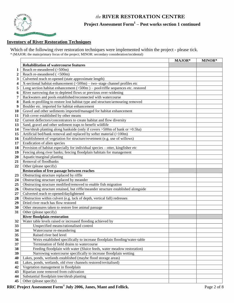
Project Assessment Form1 – Post works section 1 continued
Inventory of River Restoration Techniques
Which of the following river restoration techniques were implemented within the project - please tick. * (MAJOR: the main/primary focus of the project; MINOR: secondary consideration/incidental)
MAJOR* MINOR*
Rehabilitation of watercourse features
1 Reach re-meandered (>500m)
2 Reach re-meandered ( <500m)
3 Culverted reach re-opened (state approximate length)
4 X-sectional habitat enhancement (>500m) – two–stage channel profiles etc
5 Long section habitat enhancement (>500m ) – pool/riffle sequences etc. restored
6 River narrowing due to depleted flows or previous over-widening
7 Backwaters and pools established/reconnected with watercourse
8 Bank re-profiling to restore lost habitat type and structure/armouring removed
9 Boulder etc. imported for habitat enhancement
10 Gravel and other sediments imported/managed for habitat enhancement
11 Fish cover established by other means
12 Current deflectors/concentrators to create habitat and flow diversity
13 Sand, gravel and other sediment traps to benefit wildlife
14 Tree/shrub planting along bankside (only if covers >500m of bank or >0.5ha)
15 Artificial bed/bank removal and replaced by softer material (>100m)
16 Establishment of vegetation for structure/revetment (e.g. use of willows)
17 Eradication of alien species
18 Provision of habitat especially for individual species – otter, kingfisher etc
19 Fencing along river banks; fencing floodplain habitats for management
20 Aquatic/marginal planting
21 Removal of floodbanks
22 Other (please specify)
Restoration of free passage between reaches
23 Obstructing structure replaced by riffle
24 Obstructing structure replaced by meander
25 Obstructing structure modified/removed to enable fish migration
26 Obstructing structure retained, but riffle/meander structure established alongside
27 Culverted reach re-opened/daylightened
28 Obstruction within culvert (e.g. lack of depth, vertical fall) redresses
29 Dried river reach has flow restored
30 Other measures taken to restore free animal passage
31 Other (please specify)
River floodplain restoration
32 Water table levels raised or increased flooding achieved by
33 Unspecified means/rationalised control
34 Watercourse re-meandering
35 Raised river bed level
36 Weirs established specifically to increase floodplain flooding/water-table
37 Termination of field drains to watercourse
38 Feeding floodplain with water (Sluice feeds, water meadow restoration)
39 Narrowing watercourse specifically to increase floodplain wetting
40 Lakes, ponds, wetlands established (maybe flood storage areas)
41 Lakes, ponds, wetlands, old river channels restored/revitalised)
42 Vegetation management in floodplain
43 Riparian zone removed from cultivation
44 Substantial floodplain tree/shrub planting
45 Other (please specify)
the RIVER RESTORATION CENTRE
RRC Project Assessment Form©
July 2006, Janes, Mant and Fellick. Page 3 of 8
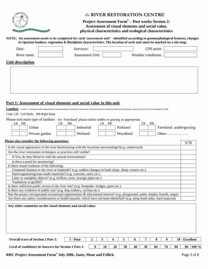
Project Assessment Form1 – Post works Section 2:
Assessment of visual elements and social value,
physical characteristics and ecological characteristics
NOTE: An assessment needs to be completed for each ‘assessment unit’ - identified according to geomorphological features, changes
in riparian landuse, vegetation & floodplain characteristics. The location of each unit must be marked on a site map.
Date: Surveyor: GPS point:
River name: Assessment Unit: Weather conditions:
Unit description
Part 1: Assessment of visual elements and social value in this unit
Landuse ‘Landuse’ assessment table adapted from Geomorphological Sensitivity Assessment, Detailed Catchment Baseline Review Environment Agency & University of Southampton, 2000
Code: LB - Left Bank; RB-Right Bank
Please tick main type of landuse – for ‘Farmland’ please delete arable or grazing as appropriate LB RB LB RB LB RB LB RB
Urban Industrial Parkland Farmland: arable/grazing
Private garden Wetland Woodland Other………………
Please also consider the following questions:
Y/N Is the visual appearance of the river harmonizing with the locations surroundings?(e.g. urban/rural) Are the river restoration techniques or practices still visible?
If Yes, do they blend in with the natural environment? Is there a need for monitoring?
Is there visual evidence of the following:
Unnatural features to the river or bankside? (e.g. sudden changes in bank slope, sharp corners etc.)
Hard engineering/man made materials? (e.g. concrete, steel, etc.)
Litter or unsightly objects? (e.g. trolleys, tyres, sewage pipes etc.)
Vandalism or graffiti?
Is there sufficient public access to the river site? (e.g. footpaths, bridges, gates etc.)
Is there any evidence of public use? (e.g. dog walkers, cyclists etc.)
Has the project incorporated recreational opportunities & educational interest? (e.g. playground, paths, display boards, maps)
Are there any safety considerations or health hazards, which have not been identified? (e.g. steep bank sides, hard material)
Any other comments on the visual elements and social value:
Overall score of Section 2 Part 1: 1 - Poor 2 3 4 5 6 7 8 9 10 - Excellent
Level of confidence in Answers for Section 2 Part 1: 0 10 20 30 40 50 60 70 80 90 100 %
the RIVER RESTORATION CENTRE
RRC Project Assessment Form©
July 2006, Janes, Mant and Fellick. Page 4 of 8
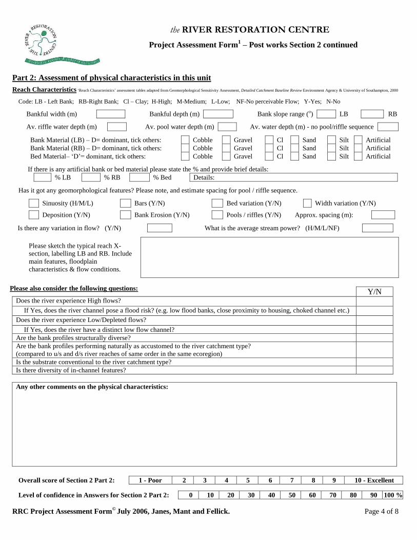
Project Assessment Form1 – Post works Section 2 continued
Part 2: Assessment of physical characteristics in this unit
Reach Characteristics ‘Reach Characteristics’ assessment tables adapted from Geomorphological Sensitivity Assessment, Detailed Catchment Baseline Review Environment Agency & University of Southampton, 2000
Code: LB - Left Bank; RB-Right Bank; Cl – Clay; H-High; M-Medium; L-Low; NF-No perceivable Flow; Y-Yes; N-No
Bankful width (m) Bankful depth (m) Bank slope range (o) LB RB
Av. riffle water depth (m) Av. pool water depth (m) Av. water depth (m) - no pool/riffle sequence
Bank Material (LB) – D= dominant, tick others: Cobble Gravel Cl Sand Silt Artificial
Bank Material (RB) – D= dominant, tick others: Cobble Gravel Cl Sand Silt Artificial
Bed Material– ‘D’= dominant, tick others: Cobble Gravel Cl Sand Silt Artificial
If there is any artificial bank or bed material please state the % and provide brief details:
% LB % RB % Bed Details:
Has it got any geomorphological features? Please note, and estimate spacing for pool / riffle sequence.
Sinuosity (H/M/L) Bars (Y/N) Bed variation (Y/N) Width variation (Y/N)
Deposition (Y/N) Bank Erosion (Y/N) Pools / riffles (Y/N) Approx. spacing (m):
Is there any variation in flow? (Y/N) What is the average stream power? (H/M/L/NF)
Please sketch the typical reach X-
section, labelling LB and RB. Include
main features, floodplain
characteristics & flow conditions.
Please also consider the following questions:
Y/N Does the river experience High flows? If Yes, does the river channel pose a flood risk? (e.g. low flood banks, close proximity to housing, choked channel etc.)
Does the river experience Low/Depleted flows? If Yes, does the river have a distinct low flow channel?
Are the bank profiles structurally diverse?
Are the bank profiles performing naturally as accustomed to the river catchment type?
(compared to u/s and d/s river reaches of same order in the same ecoregion)
Is the substrate conventional to the river catchment type?
Is there diversity of in-channel features?
Any other comments on the physical characteristics:
Overall score of Section 2 Part 2: 1 - Poor 2 3 4 5 6 7 8 9 10 - Excellent
Level of confidence in Answers for Section 2 Part 2: 0 10 20 30 40 50 60 70 80 90 100 %
the RIVER RESTORATION CENTRE
RRC Project Assessment Form©
July 2006, Janes, Mant and Fellick. Page 5 of 8
Project Assessment Form1 – Post works Section 2 continued
Part 3a: Assessment of ecological characteristics in this unit - Vegetation
Vegetation ‘Vegetation’ assessment tables adapted from Geomorphological Sensitivity Assessment Sheet, Detailed Catchment Baseline Review Environment Agency & University of Southampton, 2000
Av. in-channel cover (%): Av. Marginal cover (%): Av. Bank cover (%): LB RB
Av. tree cover (%): LB RB Are there any invasive species present (Y/N) Specify……………
Please also consider the following questions:
Y/N Is there diversity of vegetation types: In-channel? (e.g. emergent, marginal, floating and submerged)
Bankside? (e.g. bryophytes, short herbs, tall herbs or grasses, scrubs or shrubs and trees) Riparian? (e.g. mixed woodland, coniferous plantation, orchard, heath, scrub, pasture, wetland and urban development)
Is the vegetation native/natural/? (compared to u/s and d/s or river reaches of same order in the same ecoregion)
Is there a need for monitoring/maintenance?
Has there been any planting or seeding?
If Yes, has it taken well?
Any other comments on the ecological vegetation characteristics:
Overall score of Section 2 Part 3a: 1 - Poor 2 3 4 5 6 7 8 9 10 - Excellent
Level of confidence in Answers for Section 2 Part 3a: 0 10 20 30 40 50 60 70 80 90 100 %
Part 3b: Assessment of ecological characteristics in this unit - Fish & Aquatic Invertebrates
Please consider the following questions:
Y/N Are the following habitat characteristics present:
Diversity of flow types?
Diverse river bed? (substrate and structure)
Stream cover, shelter and shading?
Resting places and refuge?
Clear fish passage and habitat connectivity between u/s and d/s?
Lateral diversity between the river and floodplain?
Food sources? (e.g. bankside trees, bushes and scrub – a source of terrestrial invertebrates)
Was an improvement in fisheries part of the initial aim of the river restoration project?
If No, has the river restoration project been beneficial to fisheries?
Is there any evidence of fish using the habitat?
Any other comments on the ecological Fish and Aquatic Invertebrate habitat:
Overall score of Section 2 Part 3b: 1 - Poor 2 3 4 5 6 7 8 9 10 - Excellent
Level of confidence in Answers for Section 2 Part 3b: 0 10 20 30 40 50 60 70 80 90 100 %
the RIVER RESTORATION CENTRE
RRC Project Assessment Form©
July 2006, Janes, Mant and Fellick. Page 6 of 8
Project Assessment Form1 – Post works Section 2 continued,
& Section 3: Identification of Potential Impacts
Part 3c: Assessment of ecological characteristics in this unit – Mammals, Terrestrial invertebrates, Birds
Please consider the following questions:
Y/N Was an improvement in a particular mammal habitat part of the main objectives of the river restoration project?
Was an improvement in a particular terrestrial invertebrate habitat part of the main objectives of the river restoration project?
Was an improvement in a particular mammal bird part of the main objectives of the river restoration project? Are the following habitat characteristics present:
Shelter and cover? (e.g. bankside trees, bushes and scrub)
Diversity in emergent, bankside & riparian vegetation?
Lateral diversity between the river and floodplain?
Any other comments on the ecological habitat for mammals, terrestrial invertebrates and birds:
Overall score of Section 2 Part 3c: 1 - Poor 2 3 4 5 6 7 8 9 10 - Excellent
Level of confidence in Answers for Section 2 Part 3c: 0 10 20 30 40 50 60 70 80 90 100 %
Project Assessment Form – Post works Section 3: Identification of Potential Impacts of the restoration works
Comment on potential impacts of works on this unit & identify perceived degree of impact (High, Medium, Low, Negligible)
Short Term
+ve H/M/L/N -ve H/M/L/N
Hydro geomorphology
Vegetation
Fish & Aquatic Invert’s.
Mammals
Terrestrial Invertebrates
Birds
Visual & Social
Long Term
+ve H/M/L/N -ve H/M/L/N
Hydro geomorphology
Vegetation
Fish & Aquatic Invert’s.
Mammals
Terrestrial Invertebrates
Birds
Visual & Social
Level of confidence in Answers for Section 3: 0 10 20 30 40 50 60 70 80 90 100 %
the RIVER RESTORATION CENTRE
RRC Project Assessment Form©
July 2006, Janes, Mant and Fellick. Page 7 of 8
Project Assessment Form1 – Post works Section 4:
Appraisal of Techniques and Overall evaluation of the project
Appraisal of Techniques
Please take a photograph of each technique or change implemented, wherever possible; and for each of the
‘ticked’ practices, please consider the following questions on-site:
Technique number - taken from table on page 2
Is the technique: (Y/N)
Still in place?
Functioning as intended/producing the desired effect?
Working with natural processes?
Appropriate to the river type?
Score 1-10 (1 = Poor, 10 = Excellent)
With hindsight, were any of the techniques unnecessary or avoidable? In your view, are there any alternative
techniques, which should have been implemented? Please comment:
Overall evaluation of the project
Please consider the following questions for evaluating the project on the basis of your evaluations in Sections 2 & 3:
Overall, is the river restoration project proceeding in the right direction to achieve its objectives?
Is there any evidence of unexpected negative outcomes of the project?
Has the project gained any other benefits?
Are there any areas of the project where further work or regular maintenance may be required?
Overall score for the project2: 1 - Poor 2 3 4 5 6 7 8 9 10 - Excellent
Level of confidence in Answers for Section 4: 0 10 20 30 40 50 60 70 80 90 100 %
2 Please consider scores awarded in Section 2 of this assessment when deciding upon the overall score of the project
the RIVER RESTORATION CENTRE
RRC Project Assessment Form©
July 2006, Janes, Mant and Fellick. Page 8 of 8
Project Assessment Form – Post works Section 5:
Future improvements and management
Please tick all the issues that still apply to this site:
Artificial banks Over wide
Artificial bed Over deep
Choked channel – urban and natural debris Overgrown riparian trees – too much shade
Culvert blockage Straightened
CSO or drains present/water quality issue Unacceptable bank erosion
No amenity value – river cut off from urban area Unacceptable siltation
No in channel features Urban debris
No in channel vegetation In-channel obstruction (e.g. weir)
No tree cover Other – specify
or use to expand
on key issues
Does the river pose a serious flood risk in this location? (Y/N) If Yes provide details:…………………….
………………………………………………………………………………………………………………………………...
Potential for adaptive management and future restoration
Please tick all that apply, if you wish to expand on the key potential ‘technique’ please do so in Additional Comments box
Artificial bank removal – LB Plant riparian vegetation
Artificial bank removal – RB Raise bed level e.g. substrate enhancement, woody debris
Artificial bed removal Re-meander
Fencing Riparian vegetation management
In channel feature enhancement – pools / riffles Re-profile banks
Increased in-channel sinuosity (current location) SUDS or further investigation re. water quality
Local community gain3 - specify in ‘other’ box Urban debris management (local community)
Narrow Weir removal/lowering
‘Natural’ bank protection Flood storage e.g. floodplain re-connection
Plant marginal vegetation Other – specify
Additional Comments
Level of confidence in Answers for Section 5: 0 10 20 30 40 50 60 70 80 90 100 %
3 Such restoration techniques might include improving access by installing bridges and dipping platforms, removing bankside vegetation etc. many of
these ‘techniques’ can be specified under already identified ‘techniques’, additional suggestions should be specified in the ‘Other’ box


![W Z } v W - GNBCC · u ] o W ] v ( } u Z P Z X } u t W Á Á Á X u Z P Z X } u W Z } v W ì î ð ï î ò ð î ñ W W X K } Æ t i ï î ð U Æ ] v ] v o µ } } v } ( Z](https://img.pdfslide.us/doc/110x75/5f9c7e9a737a5206f927c6e0/w-z-v-w-gnbcc-u-o-w-v-u-z-p-z-x-u-t-w-x-u-z-p-z-x-u-w-z.jpg)


![Italia epigrafica digitale Mainardis 1 - units.it · 2018. 6. 29. · U U WT V O U X[ ]Z U WY \ W U ^ Z _TWV W ` b _ c Z W e d f U h T _ _ W _ T j [ iU WT W k lU [ _ T c [ U h _ WT](https://img.pdfslide.us/doc/110x75/5fcf6d479dcf140a01405ca9/italia-epigrafica-digitale-mainardis-1-unitsit-2018-6-29-u-u-wt-v-o-u-x.jpg)
![^ u o o µ ] o ] v P W ] ] ] } v > } v W } P u...h August 2020 ^ u o o µ ] o ] v P W ] ] ] } v > } v W } P u, Z [ ^ u o o µ ] o ] v P W ] ] ] } v > } v W } P u } À ] P } i ( ] v](https://img.pdfslide.us/doc/110x75/61255bcc660d0b5c0765fc8b/-u-o-o-o-v-p-w-v-v-w-p-u-h-august-2020-u-o-o-.jpg)

![^ u W } ] v P · 2021. 1. 27. · ^ u W } ] v P> ì ñ W ^ u W } ] v P ^ ï ï ï U t ] v î ì î ... Microsoft PowerPoint - 05-C-stream-processing.pptx Author: zahor Created Date:](https://img.pdfslide.us/doc/110x75/60f6b9abf899600cc0355d24/-u-w-v-p-2021-1-27-u-w-v-p-w-u-w-v-p-.jpg)


![^ µ } ] v P ] v ( } u ] } v · 2019. 7. 31. · ^ í ^ µ } ] v P ] v ( } u ] } v ^ Ç v Z ] } ( Ç u u ] ^ W } o Ç u Ç W } r } o Ç u ] ] } v D } ] ( ] ] } v v W Z } } u ] W }](https://img.pdfslide.us/doc/110x75/607a2fcdce666e4a9c2f70e6/-v-p-v-u-v-2019-7-31-v-p-v-u-v-.jpg)


![W } ] o ] Ç · Ç Z µ o W u v t^ } v ~W ð u } W W u v t^ } v tE } o ] ( ~> í ð í](https://img.pdfslide.us/doc/110x75/5c12924c09d3f224238b4624/w-o-c-c-z-o-w-u-v-t-v-w-d-u-w-w-u-v-t-v-te-o-i.jpg)
![u ] W } u } ] } v o ] ] } v & } u t E } v W } ( } ] o d Z](https://img.pdfslide.us/doc/110x75/629c9e74e87459440f35fe1d/u-w-u-v-o-v-amp-u-t-e-v-w-o-d-z-.jpg)