Embed Size (px)
Citation preview
Rio
Mati
lde
Punta Cucharas
PREPACosta Sur
BTB Corp.ProCaribe
Placco
CORCO
Rio Ta
llaboa
ECOELECTRICA
Peñuelas
!S(
!S(
!R(
!R(
!E(!E(
!d
!d
!̂
!̂!̂
!̂m
"(
"(
"("(
"(
"(
"("(
"(
!h
!h
!q !q
#
#
!d(
XXX
XXX XXX
Ponce
[sBahia de
PonceLaguna de las Salinas
Isla de Cardona
!d
Cayo Parguera
Cayo Rio
Cayo Caribe
Cayo Palomas
Cayo MariaLanga
PeñuelasPonce
!̂
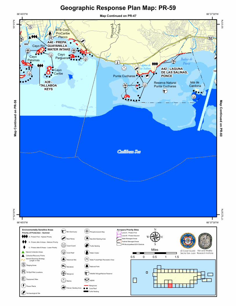
A39 -TALLABOA
KEYS
A40 - PREPAGUAYANILLAWATER INTAKE
A42 - LAGUNADE LAS SALINAS, PONCE
500
600
1550
3400
Caribbean SeaCaribbean Sea
Reserva NaturalPunta Cucharas
[r
£¤52
£¤2
66°37'30"W
66°37'30"W
66°45'0"W
66°45'0"W18
°0'0"
N
18°0
'0"N
17°5
2'30"N
17°5
2'30"N
0.5 0 0.5 1 1.5
Milesµ
Geographic Response Plan Map: PR-59
Environmentally Sensitive AreasPriority of Protection - Summer
XXXA - Protect First - Highest Priority
XX B - Protect after A Areas - Medium Priority
X C - Protect after B Areas - Lower Priority
# Natural Collection Areas
# Collection/Recovery PointsGeneral Booming Strategy Length in Feet
!S( Staging Areas
!R( Oil Spill Risk Locations
!E( Equipment Sites
!d( Power Plants
[¿ Archaeological Site
r Bird Sanctuary
!d Boat Ramp
[s Coast Guard
!̂ Coral Reef
[e Historical Site
!¤ Manatees
"( Mangrove
!h Marina
[̀ Pelican Nesting Area
[û! Phosphorescent Bay
!¢ Sea Bird Nesting Area
[¶ Turtle Nesting
!q Water Intake
k State Forest/High Recreation Area
[j National Park
[r Wildlife Refuge/Nature Reserve
[v NERR
MangrovesCoral ReefTurtle Nesting
Acropora Priority Sites
!!!
!!!
!! Level A - Protect First
!!
! !
!
!!! Level B - Protect SecondState Managed AreasFederal Managed AreasPR Municipalities/USVI Districts
Fish and Wildlife Research Institute
US Coast Guard Sector San Juan
Map Continued on PR-47Ma
p Con
tinue
d on P
R-58
Map Continued on PR-60
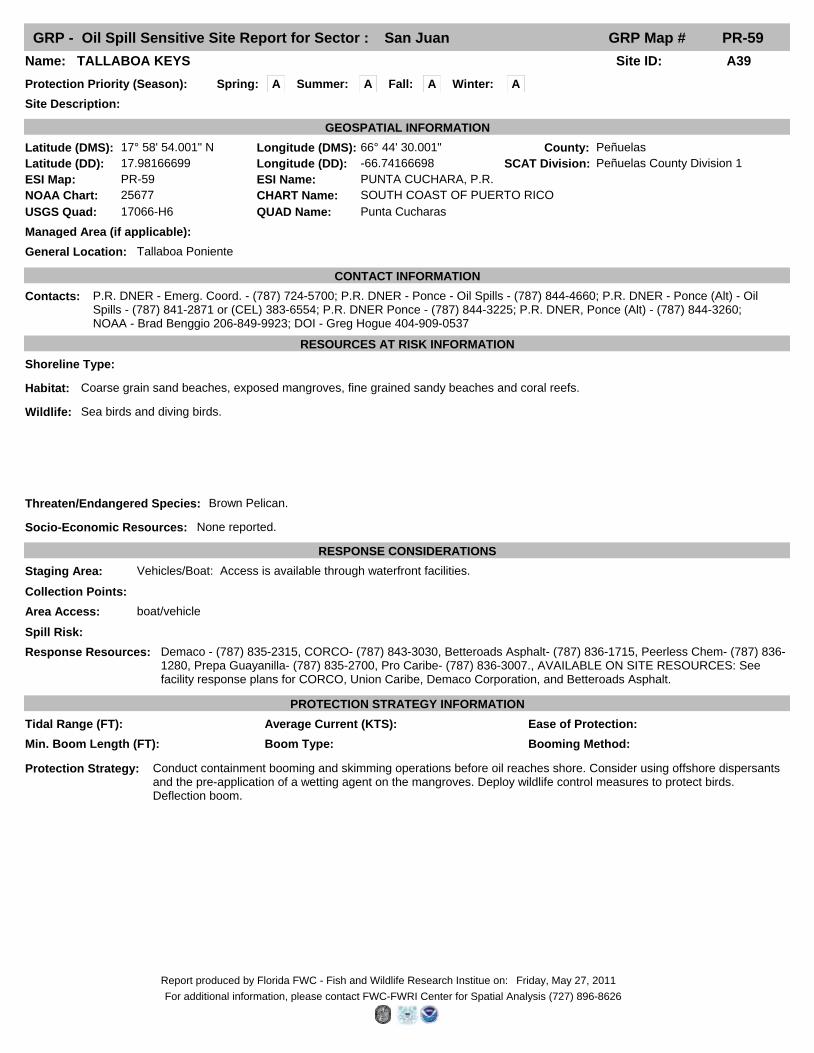
GRP - Oil Spill Sensitive Site Report for Sector : San Juan GRP Map # PR-59
Fall: ASpring: A Winter: A
Site ID: A39Name: TALLABOA KEYS
Site Description:
Protection Priority (Season):
County: Peñuelas
General Location: Tallaboa Poniente
SCAT Division: Peñuelas County Division 1
Managed Area (if applicable):
Latitude (DMS): 17° 58' 54.001" N Longitude (DMS): 66° 44' 30.001"
Latitude (DD): 17.98166699 Longitude (DD): -66.74166698
GEOSPATIAL INFORMATION
ESI Map: PR-59 ESI Name: PUNTA CUCHARA, P.R.
NOAA Chart: 25677 CHART Name: SOUTH COAST OF PUERTO RICO
USGS Quad: 17066-H6 QUAD Name: Punta Cucharas
CONTACT INFORMATION
Contacts: P.R. DNER - Emerg. Coord. - (787) 724-5700; P.R. DNER - Ponce - Oil Spills - (787) 844-4660; P.R. DNER - Ponce (Alt) - Oil Spills - (787) 841-2871 or (CEL) 383-6554; P.R. DNER Ponce - (787) 844-3225; P.R. DNER, Ponce (Alt) - (787) 844-3260; NOAA - Brad Benggio 206-849-9923; DOI - Greg Hogue 404-909-0537
RESOURCES AT RISK INFORMATION
Shoreline Type:
Habitat: Coarse grain sand beaches, exposed mangroves, fine grained sandy beaches and coral reefs.
Wildlife: Sea birds and diving birds.
Threaten/Endangered Species: Brown Pelican.
Socio-Economic Resources: None reported.
RESPONSE CONSIDERATIONS
Staging Area: Vehicles/Boat: Access is available through waterfront facilities.
Collection Points:
Area Access: boat/vehicle
Spill Risk:
Response Resources: Demaco - (787) 835-2315, CORCO- (787) 843-3030, Betteroads Asphalt- (787) 836-1715, Peerless Chem- (787) 836-1280, Prepa Guayanilla- (787) 835-2700, Pro Caribe- (787) 836-3007., AVAILABLE ON SITE RESOURCES: See facility response plans for CORCO, Union Caribe, Demaco Corporation, and Betteroads Asphalt.
PROTECTION STRATEGY INFORMATION
Min. Boom Length (FT): Booming Method: Boom Type:
Protection Strategy: Conduct containment booming and skimming operations before oil reaches shore. Consider using offshore dispersants and the pre-application of a wetting agent on the mangroves. Deploy wildlife control measures to protect birds. Deflection boom.
Tidal Range (FT): Average Current (KTS): Ease of Protection:
Summer: A
Friday, May 27, 2011Report produced by Florida FWC - Fish and Wildlife Research Institue on:
For additional information, please contact FWC-FWRI Center for Spatial Analysis (727) 896-8626
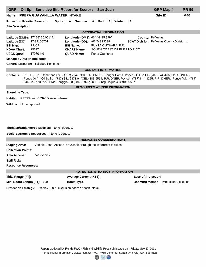
GRP - Oil Spill Sensitive Site Report for Sector : San Juan GRP Map # PR-59
Fall: ASpring: A Winter: A
Site ID: A40Name: PREPA GUAYANILLA WATER INTAKE
Site Description:
Protection Priority (Season):
County: Peñuelas
General Location: Tallaboa Poniente
SCAT Division: Peñuelas County Division 1
Managed Area (if applicable):
Latitude (DMS): 17° 59' 30.001" N Longitude (DMS): 66° 44' 35.999"
Latitude (DD): 17.99166701 Longitude (DD): -66.74333298
GEOSPATIAL INFORMATION
ESI Map: PR-59 ESI Name: PUNTA CUCHARA, P.R.
NOAA Chart: 25677 CHART Name: SOUTH COAST OF PUERTO RICO
USGS Quad: 17066-H6 QUAD Name: Punta Cucharas
CONTACT INFORMATION
Contacts: P.R. DNER - Command Ctr. - (787) 724-5700; P.R. DNER - Ranger Corps. Ponce - Oil Spills - (787) 844-4660; P.R. DNER - Ponce (Alt) - Oil Spills - (787) 841-2871 or (CEL) 383-6554; P.R. DNER, Ponce - (787) 844-3225; P.R. DNER, Ponce (Alt)- (787) 844-3260; NOAA - Brad Benggio (206) 849-9923; DOI - Greg Hogue 404-909-0537
RESOURCES AT RISK INFORMATION
Shoreline Type:
Habitat: PREPA and CORCO water intakes.
Wildlife: None reported.
Threaten/Endangered Species: None reported.
Socio-Economic Resources: None reported.
RESPONSE CONSIDERATIONS
Staging Area: Vehicle/Boat: Access is available through the waterfront facilities.
Collection Points:
Area Access: boat/vehicle
Spill Risk:
Response Resources:
PROTECTION STRATEGY INFORMATION
Min. Boom Length (FT): 100 Booming Method: Protection/ExclusionBoom Type:
Protection Strategy: Deploy 100 ft. exclusion boom at each intake.
Tidal Range (FT): Average Current (KTS): Ease of Protection:
Summer: A
Friday, May 27, 2011Report produced by Florida FWC - Fish and Wildlife Research Institue on:
For additional information, please contact FWC-FWRI Center for Spatial Analysis (727) 896-8626
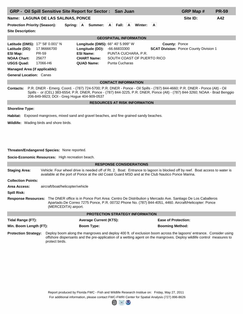
GRP - Oil Spill Sensitive Site Report for Sector : San Juan GRP Map # PR-59
Fall: ASpring: A Winter: A
Site ID: A42Name: LAGUNA DE LAS SALINAS, PONCE
Site Description:
Protection Priority (Season):
County: Ponce
General Location: Canas
SCAT Division: Ponce County Division 1
Managed Area (if applicable):
Latitude (DMS): 17° 58' 0.001" N Longitude (DMS): 66° 40' 5.999" W
Latitude (DD): 17.96666700 Longitude (DD): -66.66833300
GEOSPATIAL INFORMATION
ESI Map: PR-59 ESI Name: PUNTA CUCHARA, P.R.
NOAA Chart: 25677 CHART Name: SOUTH COAST OF PUERTO RICO
USGS Quad: 17066-H6 QUAD Name: Punta Cucharas
CONTACT INFORMATION
Contacts: P.R. DNER - Emerg. Coord. - (787) 724-5700; P.R. DNER - Ponce - Oil Spills - (787) 844-4660; P.R. DNER - Ponce (Alt) - Oil Spills - or (CEL) 383-6554; P.R. DNER, Ponce - (787) 844-3225, P.R. DNER, Ponce (Alt) - (787) 844-3260; NOAA - Brad Benggio 206-849-9923; DOI - Greg Hogue 404-909-0537
RESOURCES AT RISK INFORMATION
Shoreline Type:
Habitat: Exposed mangroves, mixed sand and gravel beaches, and fine grained sandy beaches.
Wildlife: Wading birds and shore birds.
Threaten/Endangered Species: None reported.
Socio-Economic Resources: High recreation beach.
RESPONSE CONSIDERATIONS
Staging Area: Vehicle: Four wheel drive is needed off of Rt. 2. Boat: Entrance to lagoon is blocked off by reef. Boat access to water is available at the port of Ponce at the old Coast Guard MSD and at the Club Nautico Ponce Marina.
Collection Points:
Area Access: aircraft/boat/helicopter/vehicle
Spill Risk:
Response Resources: The DNER office is in Ponce Port Area: Centro De Distribulion y Mercado Ave. Santiago De Los Caballeros Apartado.De Correo 7275 Ponce, P.R. 00732 Phone No. (787) 844-4051, 4460. Aircraft/Helicopter: Ponce (MERCEDITA) airport.
PROTECTION STRATEGY INFORMATION
Min. Boom Length (FT): Booming Method: Boom Type:
Protection Strategy: Deploy boom along the mangroves and deploy 400 ft. of exclusion boom across the lagoons' entrance. Consider using offshore dispersants and the pre-application of a wetting agent on the mangroves. Deploy wildlife control measures to protect birds.
Tidal Range (FT): Average Current (KTS): Ease of Protection:
Summer: A
Friday, May 27, 2011Report produced by Florida FWC - Fish and Wildlife Research Institue on:
For additional information, please contact FWC-FWRI Center for Spatial Analysis (727) 896-8626