Embed Size (px)
Citation preview
Oxford Road, Bodicote,
Oxfordshire Landscape and Visual Appraisal
May 2018
On behalf of HOLLINS STRATEGIC LAND LIMITED

Landscape and Visual Appraisal
Oxford Road, Bodicote, Oxfordshire
Oxford Road, Bodicote, Oxfordshire
Landscape and Visual Appraisal
Project no. 2719
May 2018
Name Position Signature Date
Prepared by: Nigel Evers Director 26/04/2018
Reviewed by: Lindsey Evers Director 26/04/2018
Revision Date Description Prepared Reviewed
A 03/05/18 Minor text changes NJE LAE

Landscape and Visual Appraisal
Oxford Road, Bodicote, Oxfordshire
CONTENTS
1 Introduction ............................................................................................................................................... 1
1.1 Background..................................................................................................................................... 1
1.2 Scope of assessment .................................................................................................................... 1
2 Methodology .............................................................................................................................................. 3
2.1 Approach ......................................................................................................................................... 3
2.2 Desktop study ................................................................................................................................ 3
2.3 Field survey ..................................................................................................................................... 4
2.4 Study area ....................................................................................................................................... 4
3 Landscape context and analysis ............................................................................................................. 6
3.1 Site location and description ...................................................................................................... 6
3.2 Vegetation ....................................................................................................................................... 6
3.3 Landform and watercourses ...................................................................................................... 7
3.4 Settlement ....................................................................................................................................... 7
3.5 Landscape planning context ...................................................................................................... 7
3.6 Landscape character .................................................................................................................. 11
4 Visual analysis .......................................................................................................................................... 16
4.1 Introduction .................................................................................................................................. 16
4.2 Visual analysis .............................................................................................................................. 16
4.3 Summary ....................................................................................................................................... 17
5 Opportunities, constraints and landscape strategy .......................................................................... 18
5.1 Opportunities and constraints ................................................................................................. 18
5.2 Landscape strategy ..................................................................................................................... 19
6 Appraisal ................................................................................................................................................... 20
6.1 Development proposals ............................................................................................................ 20
6.2 Landscape appraisal of the proposals ................................................................................... 20
6.3 Visual appraisal of the proposals ............................................................................................ 21
6.4 Summary ....................................................................................................................................... 22
7 Conclusions .............................................................................................................................................. 23
Landscape and Visual Appraisal
Oxford Road, Bodicote, Oxfordshire
APPENDICES
Figures
Figure L1: Landscape Planning Context
Figure L2: Landscape Character
Figure L3: Viewpoint Location Plan
Figure L4: Landscape and Visual Opportunities and Constraints
Figure L5: Landscape Strategy
Appendix A: Viewpoint Photographs
Landscape and Visual Appraisal
Oxford Road, Bodicote, Oxfordshire 1
1 INTRODUCTION
1.1 BACKGROUND
1.1.1 Viridian Landscape Planning Ltd was commissioned in March 2018 by Hollins Strategic Land
Ltd to undertake a Landscape and Visual Appraisal (LVA) of land at Oxford Road, Bodicote in
support of an outline planning application for the demolition of all existing buildings on site
and the development of up to 52 dwellings, together with car parking, open space,
landscaping and access.
1.1.2 This report presents the methodology, context and results of the landscape and visual
appraisal process, including aims and objectives of the proposed landscape strategy, which
underpins the proposed landscape design for the scheme. The methodology used for the
appraisal is provided at Section 2. The findings of the desk study and site visit are
summarised at Sections 3 and 4. Section 5 sets out the key landscape and visual constraints
and opportunities, together with the resulting landscape strategy. The landscape and visual
appraisal of the development proposals is set out at Section 6. Conclusions are set out at
Section 7.
1.1.3 To provide information for the landscape and visual appraisal process, the following plans
have been prepared:
L1: Landscape Planning Context;
L2: Landscape Character;
L3: Viewpoint Location Plan;
L4: Landscape and Visual Opportunities and Constraints; and
L5: Landscape Strategy.
1.1.4 The viewpoints which support the visual analysis of the site are represented by stitched
panoramic photographs, presented in Appendix B.
1.2 SCOPE OF ASSESSMENT
1.2.1 This LVA has been prepared by Chartered Landscape Architects at Viridian Landscape
Planning.
1.2.2 This landscape and visual appraisal report considers:
Features of the site and its context;
Landscape character, the character of the site, and its relationship to its surroundings;
Landscape-related planning designations;
Views towards the site;

Landscape and Visual Appraisal
Oxford Road, Bodicote, Oxfordshire 2
A landscape strategy designed to provide a setting for the proposed development; and
Changes to landscape features, landscape character and views arising as a result of the
development proposals.

Landscape and Visual Appraisal
Oxford Road, Bodicote, Oxfordshire 3
2 METHODOLOGY
2.1 APPROACH
2.1.1 This appraisal is based on the principles of the Guidelines for Landscape and Visual Impact
Assessment: Third Edition (GLVIA3) (Landscape Institute, IEMA, 2013).
2.1.2 The appraisal has been informed by a desktop study, followed by a field survey visit to the
site and the surrounding area.
2.2 DESKTOP STUDY
2.2.1 The desktop study comprised collation and review of published background information on
the site and surrounding context. This included a review of landscape planning policy and the
landscape character of the site, as well as information on statutory and non-statutory
landscape designations on the site or in the surrounding area.
SOURCES OF BASELINE INFORMATION
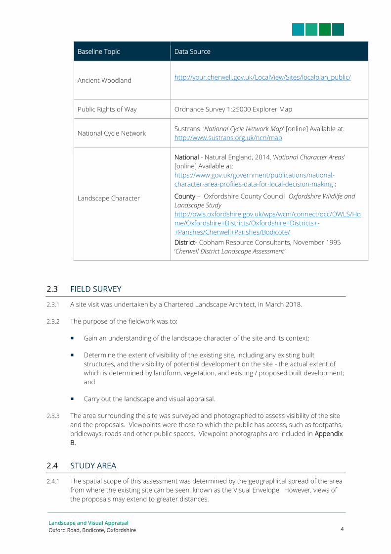
2.2.2 The sources of baseline data are summarised in Table 2.1 below:
Table 2.1: Baseline Information Sources
Baseline Topic Data Source
National Landscape Planning
Policy
NPPF
https://www.gov.uk/government/publications/national-planning-
policy-framework--2
NPPF Draft Text for Consultation, March 2018
Local Landscape Planning
Policy
Cherwell District Council
The Cherwell Local Plan (2011-2031), Adopted 20 July 2015
https://www.cherwell.gov.uk/downloads/download/45/adopted-
cherwell-local-plan-2011-2031-part-1-incorporating-policy-
bicester-13-re-adopted-on-19-december-2016
http://your.cherwell.gov.uk/LocalView/Sites/localplan_public/
Registered Parks and
Gardens, Listed Buildings and
Scheduled Monuments
http://your.cherwell.gov.uk/LocalView/Sites/localplan_public/
Conservation Areas http://your.cherwell.gov.uk/LocalView/Sites/localplan_public/
Landscape and Visual Appraisal
Oxford Road, Bodicote, Oxfordshire 4
Baseline Topic Data Source
Ancient Woodland http://your.cherwell.gov.uk/LocalView/Sites/localplan_public/
Public Rights of Way Ordnance Survey 1:25000 Explorer Map
National Cycle Network Sustrans. ‘National Cycle Network Map’ [online] Available at:
http://www.sustrans.org.uk/ncn/map
Landscape Character
National - Natural England, 2014. ‘National Character Areas’
[online] Available at:
https://www.gov.uk/government/publications/national-
character-area-profiles-data-for-local-decision-making ;
County – Oxfordshire County Council Oxfordshire Wildlife and
Landscape Study
http://owls.oxfordshire.gov.uk/wps/wcm/connect/occ/OWLS/Ho
me/Oxfordshire+Districts/Oxfordshire+Districts+-
+Parishes/Cherwell+Parishes/Bodicote/
District- Cobham Resource Consultants, November 1995
‘Cherwell District Landscape Assessment’
2.3 FIELD SURVEY
2.3.1 A site visit was undertaken by a Chartered Landscape Architect, in March 2018.
2.3.2 The purpose of the fieldwork was to:
Gain an understanding of the landscape character of the site and its context;
Determine the extent of visibility of the existing site, including any existing built
structures, and the visibility of potential development on the site - the actual extent of
which is determined by landform, vegetation, and existing / proposed built development;
and
Carry out the landscape and visual appraisal.
2.3.3 The area surrounding the site was surveyed and photographed to assess visibility of the site
and the proposals. Viewpoints were those to which the public has access, such as footpaths,
bridleways, roads and other public spaces. Viewpoint photographs are included in Appendix
B.
2.4 STUDY AREA
2.4.1 The spatial scope of this assessment was determined by the geographical spread of the area
from where the existing site can be seen, known as the Visual Envelope. However, views of
the proposals may extend to greater distances.

Landscape and Visual Appraisal
Oxford Road, Bodicote, Oxfordshire 5
2.4.2 A limit of 3km is normally set for the initial study area, beyond which our professional
experience on other assessments for this type of development has shown it is difficult to
discern landscape or visual effects. However, in this case, owing to intervening woodland,
hedges and buildings, publicly accessible viewpoints were limited to approximately 1km.

Landscape and Visual Appraisal
Oxford Road, Bodicote, Oxfordshire 6
3 LANDSCAPE CONTEXT AND ANALYSIS
3.1 SITE LOCATION AND DESCRIPTION
3.1.1 The site is located at the northern edge of Bodicote, south of Banbury, in Cherwell District.
3.1.2 The site is 2.19ha in extent and is accessed via a driveway from the northern part of White
Post Road. It is roughly in the shape of a reversed ‘L’, with a farm shop in the horizontal
stroke.
3.1.3 Buildings on the site comprise the semi-agricultural buildings of Bodicote Flyover Farm Shop
and associated outbuildings, external materials storage, caravan storage and car park, all in
the southern corner of the site.
3.1.4 The remainder of the site is occupied by grassland, across which is a scattering of mature
trees.
3.1.5 The site is bounded to the:
north west by a hedge, trimmed for much of its length to about 1.5m high, with a mature
oak about halfway along its length, and a group of mostly early mature ash, sycamore
and field maple towards the northern corner;
north east by a trimmed hedge about 1.4m high, two mature trees, and beyond the
hedge is Oxford Road (A4260);
south east by residential properties of Park End Close and associated gardens with trees;
and
south west by the grounds and buildings of Bishop Loveday Primary School, partly
separated by a line of mature trees in the school grounds.
3.2 VEGETATION
3.2.1 AWA Tree Consultants have undertaken a tree survey of the site, and of the surveyed trees,
six are retention Category A, 21 are retention Category B; and the remaining 21 trees or
groups are retention Category C.
3.2.2 AWA identified at paragraph 3.2.3 that:
‘Species diversity at the site is relatively good, with several Oak, Beech, Lime, Maple, Horse Chestnut
and Ash and occasional Hawthorn, Elder and Holly. Most of the site’s trees are mature, with
occasional early mature and semi mature trees.’
3.2.3 Additionally, at 3.2.4:
‘The site’s most significant trees are the Oak, Horse Chestnut and Beech trees situated in and around
the large grass field (T1, T3, T4, T5, T7, T8, T9 and T40). The highest value of these are the Oaks T3,
T7, T9, T40 and the Beech T1, which are large mature trees in good overall condition and provide
high amenity and arboricultural value.’

Landscape and Visual Appraisal
Oxford Road, Bodicote, Oxfordshire 7
3.2.4 At 3.2.7:
‘An adjacent row of predominantly Limes with occasional Field Maple borders the site’s western
boundary (T18 to T23, T25 to T35).’
3.2.5 All the trees on the site are covered by a Tree Preservation Order (refer to Figure L1:
Landscape Planning Context).
3.3 LANDFORM AND WATERCOURSES
3.3.1 The topography of the site and surrounding area is relatively level, with an elevation of
between about 121m in the southern corner of the site and about 123m AOD in the
northern corner. The land in the area generally rises to the north.
3.3.2 There are no watercourses or water bodies on, or in the vicinity of, the site.
3.4 SETTLEMENT
3.4.1 The site is situated on the northern edge of Bodicote, to the south of Banbury and its
extensive suburbs, as shown on. Figure L1: Landscape Planning Context. The A4260, which
runs south from Banbury, follows the eastern edge of the site. There is residential
development to the east and south of the site and a primary school to the west. Further to
the east is the new development at Longford Park, partly under construction. To the west
are the local plan housing allocations which are immediately south of the suburb of
Easington.
3.4.2 Bodicote has an historic centre, which is a Conservation Area, with suburbs to the east which
continue across the Oxford Road to Longford Park.
3.5 LANDSCAPE PLANNING CONTEXT
3.5.1 The landscape planning context for the site is shown on Figure L1: Landscape Planning
Context.
LANDSCAPE PLANNING POLICY
National Planning Policy Framework
3.5.2 National planning policy is set out in the National Planning Policy Framework (NPPF), March
2012. The overarching objective is to help achieve sustainable development. Reference is
also made to the NPPF Draft Text for Consultation, March 2018.
3.5.3 Section 11 of the NPPF, Conserving and Enhancing the Natural Environment, makes
reference to the need to create, protect, enhance and manage green infrastructure. This is
covered in Section 15 of the consultation draft.
3.5.4 Paragraph 7 sets out the three dimensions of sustainable development, including the
environmental role, which is described as:
Landscape and Visual Appraisal
Oxford Road, Bodicote, Oxfordshire 8
‘…contributing to protecting and enhancing our natural, built and historic environment; and, as
part of this, helping to improve biodiversity, use natural resources prudently, minimise waste and
pollution, and mitigate and adapt to climate change….’
3.5.5 In the consultation draft, the need to make effective use of land is added to this
environmental objective.
3.5.6 Paragraph 17 establishes 12 core land-use planning principles that underpin planning,
including that planning should:
‘always seek to secure high quality design and good standards of amenity for all existing and
future occupants of the land;
take account of the different roles and character of different areas, promoting the vitality of
our main urban areas protecting the Green Belts around them, recognising the intrinsic
character and beauty of the countryside and supporting thriving rural communities within it
…’;
3.5.7 Paragraph 56 requires good design to contribute positively to making places better for
people.
3.5.8 Paragraph 58 requires planning decisions to ensure that developments, amongst other
things:
‘will function well and add to the overall quality of the area…
establish a strong sense of place, using streetscapes and buildings to create attractive and
comfortable places to live, work and visit;
optimise the potential of the site to accommodate development, create and sustain an
appropriate mix of uses (including incorporation of green and other public space as part of
developments) …
respond to local character and history, and reflect the identity of local surroundings and
materials, while not preventing or discouraging appropriate innovation; and
are visually attractive as a result of good architecture and appropriate landscaping.’
3.5.9 Paragraph 61 states that:
‘Although visual appearance and the architecture of individual buildings are very important
factors, securing high quality and inclusive design goes beyond aesthetic considerations. Therefore,
planning policies and decisions should address the connections between people and places and the
integration of new development into the natural, built and historic environment. ’
The Cherwell Local Plan (2011-2031), Adopted 20 July 2015
3.5.10 Planning policies contained within the Local Plan that are relevant to the site and
surrounding area are summarised below.
3.5.11 Policy PSD 1: Presumption in Favour of Sustainable Development states that the Council will
take a proactive approach to reflect the presumption in favour of sustainable development
contained in the NPPF.

Landscape and Visual Appraisal
Oxford Road, Bodicote, Oxfordshire 9
‘The Council will always work proactively with applicants to jointly find solutions which mean that
proposals can be approved wherever possible, and to secure development that improves the
economic, social and environmental conditions in the area.’
3.5.12 Policy ESD 10: Protection and Enhancement of Biodiversity and the Natural Environment
states that:
‘Protection and enhancement of biodiversity and the natural environment will be achieved by the
following (inter alia):
The protection of trees will be encouraged, with an aim to increase the number of trees in the
District; and
Development proposals will be expected to incorporate features to encourage biodiversity, and
retain and where possible enhance existing features of nature conservation value within the
site.’
3.5.13 Policy ESD 13: Local Landscape Protection and Enhancement states that:
‘Opportunities will be sought to secure the enhancement of the character and appearance of the
landscape, particularly in urban fringe locations, through the restoration, management or
enhancement of existing landscapes, features or habitats and where appropriate the creation of
new ones, including the planting of woodlands, trees and hedgerows.
Development will be expected to respect and enhance local landscape character, securing
appropriate mitigation where damage to local landscape character cannot be avoided. Proposals
will not be permitted if they would:
Cause undue visual intrusion into the open countryside;
Cause undue harm to important natural landscape features and topography;
Be inconsistent with local character;
Impact on areas judged to have a high level of tranquillity;
Harm the setting of settlements, buildings, structures or other landmark features; or
Harm the historic value of the landscape.
Development proposals should have regard to the information and advice contained in the
Council's Countryside Design Summary Supplementary Planning Guidance, and the Oxfordshire
Wildlife and Landscape Study (OWLS), and be accompanied by a landscape assessment where
appropriate.’
3.5.14 Policy ESD 15: The Character of the Built and Historic Environment states that:
‘New development will be expected to complement and enhance the character of its context
through sensitive siting, layout and high quality design. All new development will be required to
meet high design standards.’
New development proposals should (inter alia):
Contribute positively to an area’s character and identity by creating or reinforcing local
distinctiveness and respecting local topography and landscape features, including skylines, valley
floors, significant trees, historic boundaries, landmarks, features or views, in particular within
designated landscapes, within the Cherwell Valley and within conservation areas and their setting.’

Landscape and Visual Appraisal
Oxford Road, Bodicote, Oxfordshire 10
3.5.15 Policy ESD 17: Green Infrastructure states that:
‘The District’s green infrastructure network will be maintained and enhanced through the following
measures (inter alia):
Ensuring that green infrastructure network considerations are integral to the planning of new
development. Proposals should maximise the opportunity to maintain and extend green
infrastructure links to form a multi-functional network of open space, providing opportunities for
walking and cycling, and connecting the towns to the urban fringe and the wider countryside
beyond.’
Banbury Vision and Masterplan: Supplementary Planning Document (December 2016)
3.5.16 The adopted Cherwell Local Plan 2015 together with the Banbury Vision and Masterplan
establishes the long term vision for the town. The Masterplan integrates planned schemes
with new opportunities and initiatives to help create a sustainable market town and regional
centre.
3.5.17 The Masterplan (at page 12) shows the site as part of an area of existing green space,
crossed by the indicative line of a new strategic link road.
CONSERVATION AREAS
3.5.18 The site is not within a Conservation Area.
3.5.19 The nearest Conservation Area is Bodicote Conservation Area, 190m to the south-west at its
nearest point, as shown on Figure L1: Landscape Planning Context. Other Conservation Areas
within 1.5km of the site include:
Oxford Canal Conservation Area, 1km to the north-east of the site; and
Banbury Conservation Area, 1.1km to the north-west of the site.
LISTED BUILDINGS
3.5.20 Listed Buildings within 1km of the site are shown on Figure L1: Landscape Planning Context.
Most of the 36 listed buildings are within Bodicote Conservation Area, including Brown Thatch
(Grade II), on the northern edge of the Conservation Area, 190m south-west of the site.
3.5.21 The nearest Listed Buildings to the site are to the north of the Conservation Area:
Lodge to Bodicote House (Grade II), 130m south-west of the site; and
Bodicote House (Grade II), 174m south of the site.
SCHEDULED MONUMENTS
There are no Scheduled Monuments within the study area.

Landscape and Visual Appraisal
Oxford Road, Bodicote, Oxfordshire 11
3.5.22 The nearest Scheduled Monument is the Former World War I National Filling Factory in
Banbury, 2.2km north-east of the site.
REGISTERED PARKS AND GARDENS
3.5.23 The site is not listed in the Register of Historic Parks and Gardens and there are no registered
parks or gardens in the study area. The nearest is at Broughton castle, 4km to the west.
ANCIENT WOODLAND
3.5.24 There is no Ancient Woodland within the study area.
PUBLIC RIGHTS OF WAY
3.5.25 Public rights of way are shown on Figure L1: Landscape Planning Context. There are no public
rights of way on, or adjacent to, the site.
3.5.26 Approximately 270m south-east of the site, a local footpath from the A4260 runs north-east
across fields to connect with two long distance paths: Oxford Canal Walk, a 133km route
following the towpath and linking Oxford to Coventry; and the Jurassic Way, a 142km route
from Banbury running north-eastward to Stamford in Lincolnshire.
NATIONAL CYCLE NETWORK
3.5.27 At its closest point, National Cycle Network Route 5 runs approximately 40m to the west of the
site, following White Post Road from Bodicote, then Salt Way and Bankside around the
southern edge of Easington.
3.6 LANDSCAPE CHARACTER
3.6.1 Figure L3: Landscape Character illustrates the published landscape character areas applicable
to the site and surrounding area.
3.6.2 Published sources describing landscape character at the National, County and District level
are:
National Character Area Profiles (Natural England, 2014);
Oxfordshire Wildlife and Landscape Study (Oxfordshire County Council, 2004); and
Cherwell District Landscape Assessment (Cobham Resource Consultants, 1995).
NATIONAL LANDSCAPE CHARACTER
3.6.3 The National Character Area profiles produced by Natural England provide a non-statutory and
overarching classification of landscape character.

Landscape and Visual Appraisal
Oxford Road, Bodicote, Oxfordshire 12
3.6.4 The site is located within National Character Area (NCA) Profile 95: Northamptonshire
Uplands (NE565, Natural England, 2014). Of the key characteristics of this NCA, the following
relate to the site and its surroundings, with comments as part of this LVA shown underlined:
‘Gently rolling rounded hills and valleys with many long, low ridgelines and great variety of
landform. Wide, far-reaching views from the edges and across the ridgetops’ – applies to the
general landform in the local area, although there are no far reaching views from the site or
its immediate context.
‘Typical ‘planned countryside’ with largely rectangular, enclosed field patterns surrounded by
distinctive, high, often A-shaped hedgerows of predominantly hawthorn and blackthorn, with
many mature hedgerow trees, mostly ash and oak’ - where not yet developed, the land to the
west has large arable fields, and although the site has hedges which contain mature trees,
the hedges are not high.
‘Nucleated villages often on hill tops or at valley heads with low densities of dispersed settlement.
Cob, ironstone and limestone in older buildings with some remaining thatch, but mostly pantile
and slate roofs. Brick buildings in some villages. Extensive new developments in villages along main
transport corridors and in the two main towns - historic Bodicote is on a hill top, but the settlement
is dominated by extensive new developments along Oxford Road and to the east...’
COUNTY LANDSCAPE CHARACTER
3.6.5 The Oxfordshire Wildlife and Landscape Study (Oxfordshire County Council, 2004) provides a
county level assessment of landscape character. The site falls into an area of Landscape
Character Type 16: Upstanding Village Farmlands, as shown on Figure L2: Landscape
Character. Key characteristics of this landscape character type are:
A steep-sided, undulating landform;
A well-defined geometric pattern of medium-sized fields enclosed by prominent hedgerows;
and
A strong settlement pattern of compact, nucleated villages of varying sizes with little dispersal
in wider countryside.
3.6.6 The site is within an area further defined as Landscape Character Area C. Bodicote, which is
described as:
“The area is characterised by large-sized fields dominated by arable farming, with some smaller
grass fields used for pony grazing. They are enclosed by low hawthorn hedges which are generally
in good condition. Hedges bordering roadsides and old lanes are taller, well-maintained and more
species-rich. There are a few young ash, field maple and oak trees in the hedges, and some small
tree clumps close to farms.”
3.6.7 Neither the site nor its immediate setting demonstrate any of the key characteristics of the
type, although fields in the countryside to the west are geometric and medium sized, but
without prominent hedgerows. In terms of Character Area C, the site is a smaller grass field,
with low hawthorn hedges, but they are not tall where they border roads. The oak trees are
not young.
3.6.8 The landscape strategy for the Upstanding Village Farmlands Landscape Character Type is to:

Landscape and Visual Appraisal
Oxford Road, Bodicote, Oxfordshire 13
“Conserve and enhance the strong pattern of hedgerows and hedgerow trees, and the nucleated
settlement pattern and strong vernacular character of the villages.”
3.6.9 Specific guidelines include:
‘Strengthen and enhance the field pattern by planting up gappy hedges using locally
characteristic species such as hawthorn, and hedgerow trees such as oak and ash;
Promote environmentally-sensitive maintenance of hedgerows, including coppicing and
layering when necessary, to maintain a height and width appropriate to the landscape type,
particularly along roadsides;
Maintain the nucleated pattern of settlements and promote the use of building materials,
characteristically the ironstones and slate tiles of the Northamptonshire Uplands, and a scale
of development that is appropriate to this landscape type.’
DISTRICT LANDSCAPE CHARACTER
3.6.10 The Cherwell District Landscape Assessment (Cobham Resource Consultants, 1995) provides
a district level assessment of landscape character, although the more recent county wide
assessment (OWLS) shows much more detail. As shown on Figure L2: Landscape Character,
the site falls between two Landscape Character Areas: the Ironstone Hills and Valleys LCA
and the Cherwell Valley LCA.
3.6.11 Ironstone Hills and Valleys extends from the Cherwell Valley to the Oxfordshire/Warwickshire
county boundary. It is an upland area which forms part of the northern extent of the
Cotswold Hills. Relevant extracts from the description of this landscape character area are:
‘The main distinguishing features are its extremely complex topography and the style of
vernacular buildings which is unique to the Banbury region. The unspoilt ironstone villages
and tranquil countryside are remote and isolated…
Since the area is faulted and uplifted, and also cut through by numerous small streams, the
landscape is divided into very steeply sided, convoluted valleys with narrow valley bottoms and
rolling, rounded hill lines.
Underlying geology has given rise to iron rich clay soils of a characteristic red colour…’
3.6.12 To the east of the A4260, which follows the eastern site boundary, is the Cherwell Valley
Landscape Character Area. Relevant extracts from the description of this landscape
character area are:
“The River Cherwell cuts down through the Marlstone Rock Bed, an iron bearing limestone, to
the Lias siltstones, mudstones and clays beneath…
The valley in the northerly part of the area is less sharply defined, as the river is joined from
the west by two major tributaries, the Sor Brook and the River Swere…
Close to settlements and on the steepest slopes, a network of small fields and mixed farming
has survived. Lines of trees resulting from outgrown hedges and small clumps of trees in field
corners give parts of the valley a locally well-treed character.”
The site demonstrates none of those characteristics.

Landscape and Visual Appraisal
Oxford Road, Bodicote, Oxfordshire 14
CATEGORY A VILLAGES: VILLAGE ANALYSIS
3.6.13 Landscape Assessment Work was undertaken in March 2016 by WYG, on behalf of Cherwell
District Council, to undertake, amongst other issues:
‘analysis of the designations and characteristics of Category A villages as set out in CDC LPP1,
Policy Villages 1: Village Categorisation to inform the selection of reasonable options for non-
strategic sites…’
Bodicote is a Category A Village.
3.6.14 At paragraph 3.7.6, the Assessment explains that:
‘The northern edge of Bodicote contains a number of established woodland blocks and open space
with single specimen and veteran trees around the junction with White Post Road and Sycamore
Drive. The central core and north south axis of the Conservation Area along High Street and
Church Street leads through the historic built frontage and south to St John the Baptist Parish
Church. Residential development to the east and south of the Conservation Area is general post
war and late 20th Century with generous gardens and a mixture of bungalow and semi detached
estate style housing.’
3.6.15 At paragraph 3.7.11, it is stated that:
‘The western extent of the village in the historic core and land beyond the village boundary is
considered highly sensitive in providing the setting for the village.’
3.6.16 It is not clear if the site is included in ‘land beyond the village boundary’. However, on
accompanying Figure 7.1C ‘Bodicote – Village Analysis’ the site is incorrectly shown as largely
a woodland parcel, with three ’notable trees’ and a symbol that represents ‘Landscape
Features’, without explaining what the feature is or its significance.
LANDSCAPE CHARACTER OF THE SITE
3.6.17 The site is partly enclosed by the hedges along the north eastern and north western
boundaries, which are trimmed to about 1.2 to 1.5 metres high, reinforced by the mature
hedgerow trees. The strong line of trees along the south western boundary largely encloses
the site and separates it from the school grounds, whilst on the south eastern boundary, it is
enclosed by the properties and gardens of Park End Close.
3.6.18 The site is strongly influenced by development, including the housing and car
dealership/filling station on Oxford Road, the Park End Close housing and the farm shop,
hard standing and caravan storage on the site itself, adjacent to the school buildings which
lie just across the site boundary.
3.6.19 From the surrounding roads and associated footpaths, the large trees on the site are the
most important characteristic. There is very little perception of the site being an open space
and no perception of it being part of the countryside. That is as a result of the influence of
adjacent development which is:
continuous housing along Oxford Road to the north east and Park End Close to the
south east;

Landscape and Visual Appraisal
Oxford Road, Bodicote, Oxfordshire 15
the large and obtrusive filling station and car dealership across Oxford Road; and
the extensive school buildings adjacent to the farm shop complex in the southern
corner.
3.6.20 The existing development can clearly be seen across the site, especially the development along
Oxford Road where regularly spaced housing and reads as being on the site boundary, despite
being on the other side of Oxford Road.
3.6.21 However, at the north western end of the site, adjacent to White Post Road (north), there is
intervisibility with the woodland on Bankside and the well wooded school grounds at the north
western end of the site, partly as a result of the slight elevation of White Post Road. The north
western end has a closer relationship with the green corridor that links with the landscape to
the west and east, than with the remainder of the site.
3.6.22 The wider context of the site is changing, given new housing under construction to the east
of Oxford Road and allocated on land to the west of White Post Road and south of Easington,
beyond the cricket club.
3.6.23 There is a loose network of visually significant vegetation that extends from the open
countryside to the west along:
Salt Way;
the trees along White Post Road, across the northern, undeveloped part of the school
grounds;
the roadside vegetation along White Post Road (north) and Bankside; and
the north eastern part of the site.
3.6.24 However, the filling station/car dealership significantly interrupts the link, although there is a
narrow parcel of cleared land between the wooded embankments of Bankside and the filling
station/car dealership which is shown in the Banbury Vision and Masterplan as an existing
green space.
3.6.25 The overall character of the site is that of an incidental field in a suburban area, with large
mature trees and enclosed by development on two sides and urban roads on three sides.

Landscape and Visual Appraisal
Oxford Road, Bodicote, Oxfordshire 16
4 VISUAL ANALYSIS
4.1 INTRODUCTION
4.1.1 Typical views towards the site were assessed from publicly available viewpoints, and are
illustrated by the panoramic photographs from Viewpoints 1-9 in Appendix A. The location of
these photograph viewpoints is shown on Figure L3: Viewpoint Location Plan. The
photographs were taken in winter, when the screening function of the vegetation is
minimised.
4.1.2 The site has limited visibility from the wider landscape, largely as a result of the mature tree
screen bounding the site and the gentle topography of the surrounding area.
4.1.3 Publicly available views of the site typically comprise local views from within 60m or so. There
are no medium distance or long distance views of the site.
4.2 VISUAL ANALYSIS
4.2.1 Viewpoint 1: this view shows the north western boundary of the site where it abuts White
Post Road (north). The full depth of the site can be seen as far as Park End Close beyond the
south -eastern boundary. The trees on the site and in the vicinity of White Post Road are an
important characteristic of the area. The housing, car dealership and filling station on the far
side of Oxford Road are prominent and negate any perception of the site being open
countryside. The farm shop is concealed by the trees along the access drive.
4.2.2 Viewpoint 2: from further east on White Post Road (north) at its junction with Oxford Road.
This shows the corner of the site with a clump of large trees and then the low, trimmed
hedge down the north eastern boundary. opposite which, across the wide carriageway of
Oxford Road, are the houses and filling station along Oxford Road, which provides the
developed context to the site. The Park End Close houses can be seen at the far end of the
site, and to the right (west), the farm shop buildings and the caravan storage. Further right,
the school buildings can be seen through the south western boundary, filtered by trees along
the access drive. Looking along White Post Road (north) to the right (west), the woodland
along Bankside (road) can be seen opposite the north western site boundary.
4.2.3 Viewpoint 3: shows the view from the junction of Broad Gap and Oxford Road, looking up
Oxford Road. In this winter view, which is part of a sequence extending north along Oxford
Road, the site, which is some 290m away, is not visible, concealed by trees between Oxford
Road and the Park End development. The wide verges, service roads and regularly spaced
semi-detached houses are characteristic approaches to towns built from the 1930s onwards.
4.2.4 Viewpoint 4: shows the view from about 185m further north than Viewpoint 3, and is about
120m from the site. The south-east corner of the site is just discernible, where the roadside
vegetation turns from trees to a closely trimmed hedge, largely subsumed by the wooded
vegetation around the Bankside crossing of Oxford Road. .
4.2.5 Viewpoint 5: shows the view from the point at which the full length of the site becomes
visible, more or less at the south eastern boundary and at the ends of the gardens of Park
End Close. All that is visible of the site are the mature trees, the boundary hedge along
Oxford Road and the tops of the caravans and farm shop buildings.

Landscape and Visual Appraisal
Oxford Road, Bodicote, Oxfordshire 17
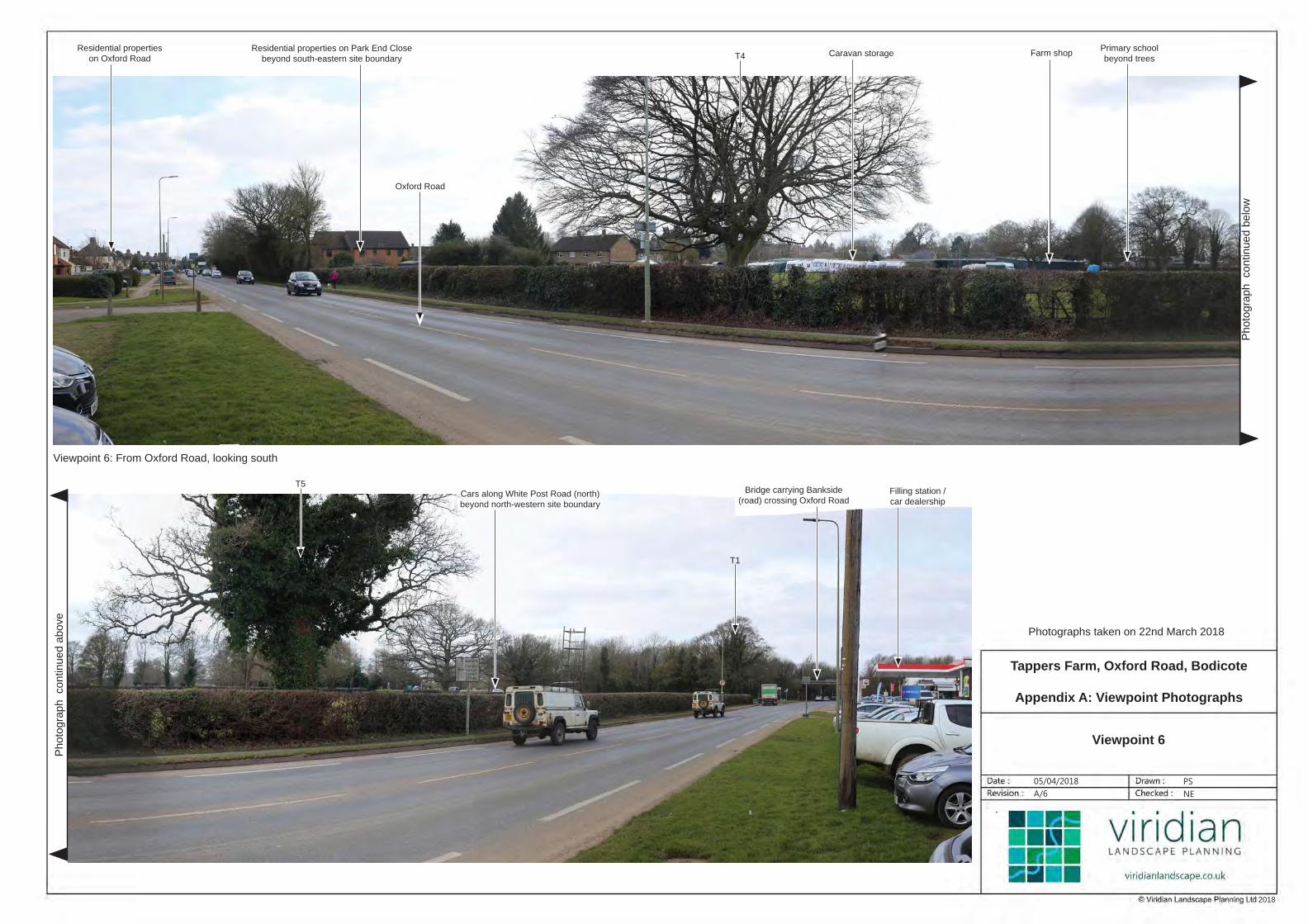
4.2.6 Viewpoint 6: Approximately 90 m north of Viewpoint 5, in this view the caravans and farm
shop are more visible, as are the houses in Park End Close. The northern edge of the site is
less influenced by development than the remainder of the site.
4.2.7 Viewpoint 7: Approximately 65m form the north western corner of the site, from Salt Way
which is a footpath and part of the National Cycle Route 5, this view incudes the northern
edge of the site on the other side of White Post Road. Largely obscured by intervening
vegetation, the filling station can be seen across the site and on the far side of Oxford Road,
as can the primary school on the other side of White Post Road. In this view, the function of
the site as open land is limited to it allowing views to the filling station, but the existing
mature trees can be seen as an integral part of the vegetation pattern in the area.
4.2.8 Viewpoint 8: Approximately 630m from the site and looking east towards it, there are no views
of the site as it is hidden by substantial vegetation. It is worth noting that much of the field
visible in the viewpoint is shown as a Strategic Housing Site in the Local Plan which now has
approval for up to 280 dwellings (15/01326/OUT).
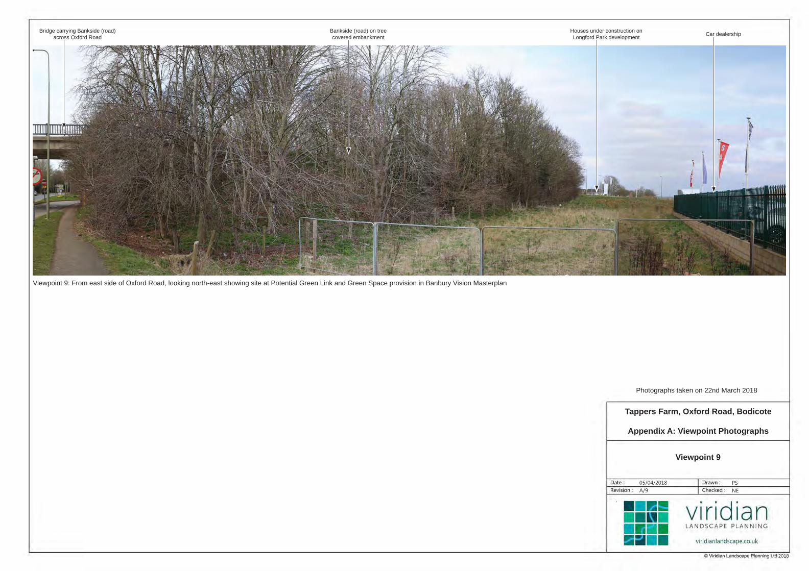
4.2.9 Viewpoint 9: This view does not show the site, but is opposite the northern end of the site on
the far side of Oxford Road. It shows a narrow strip of land which is between the car dealership
and Bankside (road) which is identified as a potential green link and green space in the Banbury
Vision Masterplan.
4.3 SUMMARY
4.3.1 The perception of users of the area is that the site is quite separate from the adjacent
countryside, and the perception of its character is that of a semi-enclosed and private parcel
of land that is heavily influenced by existing development.
4.3.2 It is adjacent to residential development on two sides and is only perceived as partly relating
to the adjoining green corridor at its northern end. There are no views of the site from public
rights of way or other sensitive receptors, except from the very eastern end of the Salt Way
where it joins White Post Road, and then only filtered views, which are across the site to the
filling station, rather than onto the site itself. The mature trees are the most characteristic
feature on the site. National Cycle Route 5 passes along the north western edge of the site,
but the experience is of an urban stretch of the route rather than a rural one.

Landscape and Visual Appraisal
Oxford Road, Bodicote, Oxfordshire 18
5 OPPORTUNITIES, CONSTRAINTS AND LANDSCAPE STRATEGY
5.1 OPPORTUNITIES AND CONSTRAINTS
5.1.1 Landscape and visual opportunities and constraints are shown on Figure L4: Landscape and
Visual Opportunities and Constraints and summarised below.
5.1.2 Certain landscape and visual characteristics of the site lead to it being able to accommodate
residential development. These characteristics include:
A strong framework of boundary vegetation comprising trees and hedges limiting views
onto the site;
Potential for enhancement and further strengthening of those boundaries;
Existing development on part of the site;
The location of the site, adjacent to existing residential development on two sides and
educational use on a third side;
The site being viewed in context of the adjacent development; and
Views of the site being limited to very local views.
5.1.3 There are potential landscape and visual constraints to development within the site, which
are set out in Table 5.1 below, along with how such constraints can be overcome or
minimised.
Table 5.1: Site Constraints
Constraint How addressed
Existing mature trees
within the site, which are
subject to a TPO and are
an important characteristic
of the site.
Proposed development minimises effects on existing
trees and hedgerows, protecting and retaining those of
highest value and allowing views to them across the
site; new planting undertaken as mitigation,
underpinned by a long-term landscape management
plan.
Local views only from
adjacent roads. Boundaries unaffected and northern part of site left
undeveloped.
Relationship with adjoining
landscape . Only the north western edge of the site is seen as part
of the adjoining landscape and so is retained within
the proposals.
Landscape and Visual Appraisal
Oxford Road, Bodicote, Oxfordshire 19
5.2 LANDSCAPE STRATEGY
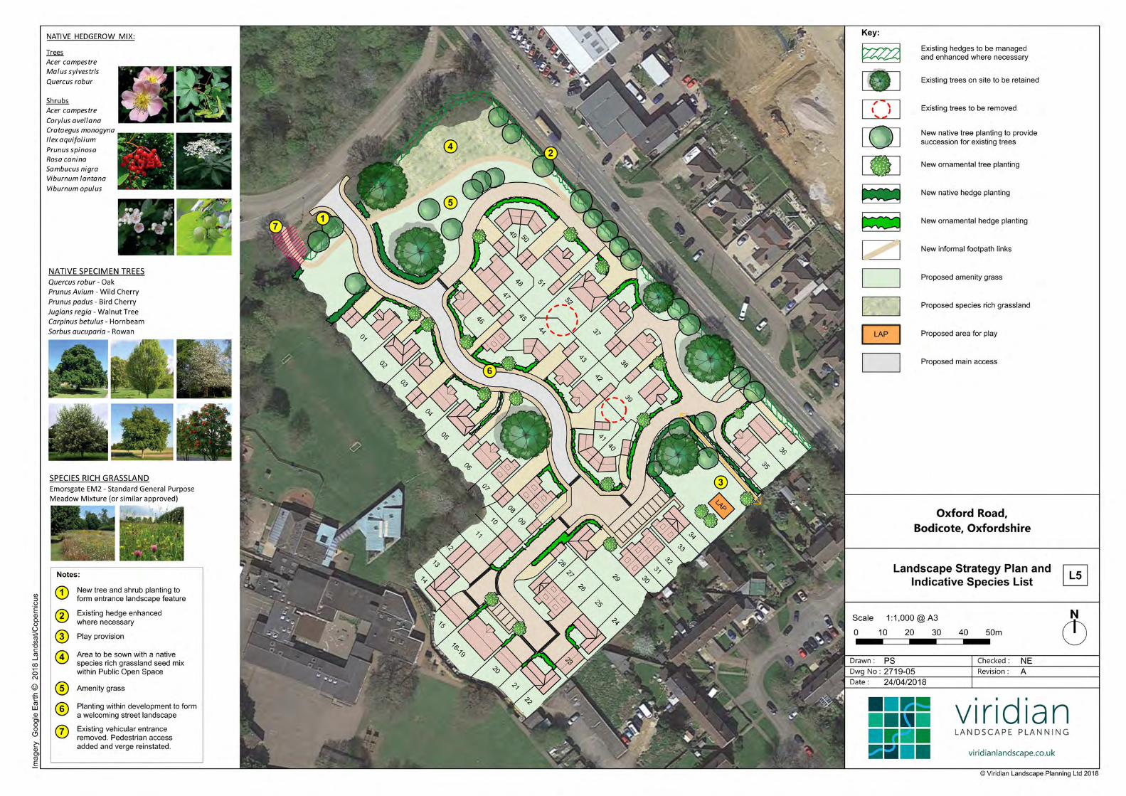
5.2.1 Taking into account the above landscape and visual opportunities and constraints, there is
potential for the site to accommodate residential development without causing unacceptable
harm to the setting of the site, views or the character of the area, subject to incorporating a
sensitive design approach and landscape strategy, as shown on Figure L5: Landscape
Strategy Plan and Indicative Species List.
5.2.2 We propose a landscape strategy for the site, based on the following principles:
Retention and protection of existing trees and hedges wherever practical and desirable;
Management and enhancement of existing vegetation, particularly to strengthen
boundaries;
Provision of publicly accessible open space;
Establishment of species rich grassland;
Implementation of new landscape proposals in keeping with the setting of the proposed
development;
Implementation of a long-term Landscape Management Plan;
Additional footpath links providing public access and an alternative route to the roadside
footpaths; and
Provision of play space.
Landscape and Visual Appraisal
Oxford Road, Bodicote, Oxfordshire 20
6 APPRAISAL
6.1 DEVELOPMENT PROPOSALS
6.1.1 The proposal is for the demolition of all existing buildings on site and the development of up
to 52 dwellings, together with car parking, open space, landscaping and access.
6.2 LANDSCAPE APPRAISAL OF THE PROPOSALS
LOCAL PLAN
6.2.1 The proposed development would comply with Local Plan Policy ESD 10 by protecting the
most important trees on the site, as identified by the project ecologist, as well as retaining
the hedges, increasing the number of trees and managing the site in accordance with an
agreed plan.
6.2.2 It would comply with Policy ESD 13 by retaining the trees and hedges, which are the most
important features of the site, and retaining the northern and eastern parts of the site for
open space.
6.2.3 Policy ESD 15 would be complied with as the layout has been sensitively designed and the
development sited to minimise effects and retain important features. Landscape planning
has been integrated into the development at an early stage, allowing the retention of most of
the existing landscape features; it relates well to the site’s topography and enhances the key
landscape features, ensuring their long term management and maintenance; likely landscape
and visual effects have been identified and an appropriate landscape strategy proposed to
reduce those effects.
6.2.4 Policy ESD 17 requires the provision of green infrastructure, which would be accommodated
on the site by open space and new planting on the northern and eastern edges. This would
link with the Council’s aspiration to provide green links in the area. The public would also
have access to the site which they do not currently have.
OTHER DESIGNATIONS
6.2.5 There are no public rights of way, National Cycle Network routes, Listed Buildings or Ancient
Woodland within the site; it is not within a Conservation Area or Registered Park and Garden.
Although there are Listed Buildings and a Conservation Area to the south, there is no
intervisibility with the site. However, National Cycle Route 5 runs along White Post Road and
Salt Way, but its context as it passes near the site is that of urban development, although
with significant tree cover and is very much an urban rather than rural route.
6.2.6 Therefore, there would be no direct landscape effects upon any of these and, as there is no
intervisibilty with the site, nor would there be any indirect landscape effects upon them.

Landscape and Visual Appraisal
Oxford Road, Bodicote, Oxfordshire 21
LANDSCAPE CHARACTER
6.2.7 There would be a change in the local landscape character of the site, as a result of the
change in use from a farm shop, caravan storage and grassland to residential development
and open space. Most of the existing mature trees and all of the hedges would be retained,
providing the proposed development with a mature landscape setting.
6.2.8 The landscape strategy aims to retain the important existing landscape characteristics and
landscape features of the site, and to manage and enhance them through the management
plan, ensuring the sustainability of the structural landscape of the site.
6.2.9 The northern part of the site is most closely related to the perceived green link, and that has
been retained to continue that function when combined with the other areas of woodland
and open space.
VEGETATION
6.2.10 Most existing trees and hedgerows on the site would be retained. The Illustrative Masterplan
demonstrates that all trees can be retained, but it is likely that two smaller, poorer quality
trees (located within proposed gardens) will need to be felled and mitigated elsewhere on
site with good quality native species trees.
6.2.11 New planting proposed within the site would be of appropriate species, in character with the
existing vegetation.
6.3 VISUAL APPRAISAL OF THE PROPOSALS
6.3.1 The viewpoint photographs are presented in Appendix A and the viewpoint locations are
shown on Figure L3.
6.3.2 The visual analysis has shown that the site is only seen locally and, with one minor exception,
from roads rather than public footpaths.
6.3.3 Viewpoint 1: this view shows the north western boundary of the site where it abuts White
Post Road (north). All existing trees in the foreground would remain and be incorporated into
the open space at the north western end of the site. A gap would be created in the hedge to
the right (west) of the tree on the boundary to enable vehicular access, but the existing
access would be closed and, apart from a pedestrian access, new hedge planting would be
introduced and the verge extended. New housing would extend the existing building line
towards the viewpoint, and additional tree planting would be established across the open
space. There would be a loss of local perception of openness but that would be restricted to
relatively low sensitivity receptors from the adjacent road.
6.3.4 Viewpoint 2: from further east on White Post Road (north) at its junction with Oxford Road.
The caravan storage and farm shop complex would be replaced with housing, which would
be brought closer to the viewpoint and seen in the context of the existing housing along the
other side of Oxford Road. All of the existing roadside hedges and trees would be retained,
which would provide a sense of scale and filter views of the new development edge, an effect
which would be enhanced with some foliage providing additional filtering. Houses would be
set back behind the hedge along Oxford Road by a strip of open space and the new road on

Landscape and Visual Appraisal
Oxford Road, Bodicote, Oxfordshire 22
the site. There would be additional tree planting in the hedge, which would provide further
filtering.
6.3.5 Viewpoint 3: shows the view from the junction of Broad Gap and Oxford Road, looking up
Oxford Road. In this winter view, which is part of a sequence extending north along Oxford
Road, the development, which would be some 290m away, would not be visible, concealed by
trees between Oxford Road and the Park End development.
6.3.6 Viewpoint 4: shows the view from about 185m further north than Viewpoint 3 and is about
120m from the site. Although the hedge adjacent to the south-east corner of the site is just
discernible, development would be set back from the hedge and is unlikely to be visible.
6.3.7 Viewpoint 5: shows the view from the point at which the full length of the site becomes
visible, more or less at the south eastern boundary and at the ends of the gardens of Park
End Close. New houses would be visible above the roadside hedge, set back from the
roadside by some 20m or so. The large trees in the foreground (respectivley from the left,
tree T5, a horse chestnut about 40m inside the site, and trees T4 and T3, both oaks and on
the boundary hedge) would be retained, forming strong landscape features within the
development. Open space would be created around the two trees on the right, ensuring
their retention and protection.
6.3.8 Viewpoint 6: Approximately 90 m north of Viewpoint 5, in this view the caravans and farm
shop would be removed. The developed edge represented by Park End Close would extend
along Oxford Road, although set back from the hedge, reflecting the houses and filling
station along Oxford Road. More houses would be visible than currently, but in a largely
developed context.
6.3.9 Viewpoint 7: Approximately 65m from the north western corner of the site, from Salt Way
which is a footpath and part of the National Cycle Route 5, this view incudes the northern
edge of the site on the other side of White Post Road. New development would be set back
from White Post Road (north) behind open space and largely obscured by intervening
vegetation. The filling station would still be seen. All existing vegetation would be retained.
6.3.10 Viewpoint 8: Approximately 630m from the site and looking east towards it, there would be
no views of the development.
6.3.11 Viewpoint 9: This view does not show the site, and there would be no effects.
6.4 SUMMARY
6.4.1 In summary, views of the proposed development would be limited to local views from roads
to the east and north. There would be no views from open countryside to the west owing to
the substantial tree cover. As a result, the effects would be localised and would be of new
development in a largely developed context, but the effects would be minimised by retention
of existing vegetation and the careful siting of development to retain the north western part
of the site as open space.

Landscape and Visual Appraisal
Oxford Road, Bodicote, Oxfordshire 23
7 CONCLUSIONS
7.1.1 The site has a strong framework of boundaries comprising trees and hedges, with the potential
for enhancement and further strengthening of those boundaries. Views of the development
would be limited to very local views owing to the framework of substantial mature tree cover.
7.1.2 Residential development on the site would be viewed in context with adjacent residential
development to the south and east.
7.1.3 Adverse effects would be minimised by the implementation of the landscape strategy and
underpinned by a long-term Landscape Management Plan, which would ensure the retention
and enhancement of the landscape of the site and, in particular, the boundary trees and
shrubs which lead to its partly enclosed character.
7.1.4 Only the northern part of the site plays any significant part in the green network in the area.

FIGURES


APPENDIX A: VIEWPOINT PHOTOGRAPHS

05/04/2018 PS- NE
© 2
017 G
oogle
Photographs taken on 22nd March 2018
2018
Viewpoint 1: From White Post Road (north), looking south-east to south towards north-western boundary of site
Bishop Loveday Primary
School and grounds beyond
Access road to Bodicote
Flyover Farm Shop
Residential properties on Park End
Close beyond south-eastern boundary
Residential properties
along Oxford Road
North-eastern boundary of
site along Oxford Road
White Post Road (south)
T1 and T41-T48 T40T9
T38
Farm shop
behind trees
Photo
gra
ph
continued b
elo
w
Photo
gra
ph
continued a
bove
Tappers Farm, Oxford Road, Bodicote
Appendix A: Viewpoint Photographs
Viewpoint 1
A/1

05/04/2018 PS- NE
© 2
017 G
oogle
Photographs taken on 22nd March 2018
2018
Trees along north-
western site boundaryWhite Post Road (north)
Viewpoint 2: From junction of White Post Road (north) and Oxford Road, looking south
Filling StationResidential development
along Oxford RoadProperties at
Park End CloseFarm Shop
Photo
gra
ph
continued b
elo
w
Photo
gra
ph
continued a
bove
T1T41-T47
T41-T47
Tappers Farm, Oxford Road, Bodicote
Appendix A: Viewpoint Photographs
Viewpoint 2
A/2

05/04/2018 PS- NE
© 2
017 G
oogle
Photographs taken on 22nd March 2018
2018
Viewpoint 3: From junction of Broad Gap and Oxford Road, looking north-west
Broad GapResidential properties
on Broad End
Filling station /
car dealershipResidential properties
on Oxford Road
Site concealed by road side trees along
north-eastern side of Park End development
Oxford Road
Tappers Farm, Oxford Road, Bodicote
Appendix A: Viewpoint Photographs
Viewpoint 3
A/3

05/04/2018 PS- NE
© 2
017 G
oogle
Photographs taken on 22nd March 2018
2018
Viewpoint 4: From Oxford Road, looking north-west
Residential properties
on Park End Court
Residential properties
at Park End CloseSouth-east
corner of site
Bridge carrying Bankside
(road) crossing Oxford Road
Filling station
Service Road
Oxford Road
Entrance to
Merlin Close
Tappers Farm, Oxford Road, Bodicote
Appendix A: Viewpoint Photographs
Viewpoint 4
A/4

05/04/2018 PS- NE
© 2
017 G
oogle
Photographs taken on 22nd March 2018
2018
Viewpoint 5: From Oxford Road, looking west across site
Woodland beyond north-western
site boundaryFarm shop / caravan storageGardens at Park End Close
Bridge carrying Bankside
(road) crossing Oxford RoadFilling station /
car dealershipT5 T4 T3
T1
Tappers Farm, Oxford Road, Bodicote
Appendix A: Viewpoint Photographs
Viewpoint 5
A/5
05/04/2018 PS- NE
© 2
017 G
oogle
Photographs taken on 22nd March 2018
2018
Viewpoint 6: From Oxford Road, looking south
Photo
gra
ph
continued b
elo
w
Photo
gra
ph
continued a
bove
Farm shopPrimary school
beyond trees
Residential properties
on Oxford RoadCaravan storage
Residential properties on Park End Close
beyond south-eastern site boundary
Oxford Road
Cars along White Post Road (north)
beyond north-western site boundary
Bridge carrying Bankside
(road) crossing Oxford RoadFilling station /
car dealership
T4
T5
T1
Tappers Farm, Oxford Road, Bodicote
Appendix A: Viewpoint Photographs
Viewpoint 6
A/6

05/04/2018 PS- NE
© 2
017 G
oogle
Photographs taken on 22nd March 2018
2018
Viewpoint 7: From Salt Way (footpath 120/43 and National Cycle Route 5) , looking south-west towards site
Filling station / car dealership
on Oxford Road beyond site
Farm Shop on southern
corner of sitePrimary schoolWhite Post Road (north)
Tappers Farm, Oxford Road, Bodicote
Appendix A: Viewpoint Photographs
Viewpoint 7
A/7

05/04/2018 PS- NE
© 2
017 G
oogle
Photographs taken on 22nd March 2018
2018
Viewpoint 8: From footpath 137/13, looking west towards the site
Residential properties
on Sycamore Drive
Site not visible
beyond treesPrimary school Banbury Cricket Club
Salt Way
(footpath 120/41 and National Cycle Route 5)
along rear of Sycamore Drive
Tappers Farm, Oxford Road, Bodicote
Appendix A: Viewpoint Photographs
Viewpoint 8
A/8
05/04/2018 PS- NE
© 2
017 G
oogle
Photographs taken on 22nd March 2018
2018
Viewpoint 9: From east side of Oxford Road, looking north-east showing site at Potential Green Link and Green Space provision in Banbury Vision Masterplan
Bridge carrying Bankside (road)
across Oxford Road
Bankside (road) on tree
covered embankment
Houses under construction on
Longford Park developmentCar dealership
Tappers Farm, Oxford Road, Bodicote
Appendix A: Viewpoint Photographs
Viewpoint 9
A/9