Embed Size (px)
Citation preview

Owstons Warehouse, investigation of south east corner of building and quay.
The emplacement of access scaffolding around the lower south east corner of Owstons Warehouse and
quay has allowed close examination of the wall for the first time.
Access to the quay from this end was obstructed by a short wall perpendicular to the south elevation of
the building, originally in line with the east wall but which had moved away. The ground level to the east
– and particularly at the corner – is lower than the quay and falls away steeply toward the river.
The brickwork of the building quoin immediately above the top of this short wall was missing or
disrupted to a height of 109” above quay level. The wall itself undercut this quoin and has moved away
from this undercutting, suggesting that it had been built as a buttress against earlier decay.
Upon the quay, within this wall, there are significant sycamore and ivy stumps, recently cut back, and
these roots may be assumed to have contributed to the disruption of this buttressing wall, as well,
perhaps, to the disruption of the building corner as a whole.
However, necessary dismantlement of this deflected wall leads to another analysis.
The wall is almost certainly contemporary with the construction of the warehouse. Its return is angled
similarly to the building and was built of the same ‘special’ bricks required to all quoins of the building
due to the lack of squareness of the site.
The brickwork rose from a large block of calcareous sandstone, the thickness and length of the wall, as
well as carved to form the same angle. This slab of stone, some 7” high is contiguous with the stones
that form the top of the quay wall and of the same geology. Significantly it also formed part of the

return of the east elevation, deliberately undercutting the quoin – three courses of brickwork abut its
north end and were clearly built against it. The junction of the brickwork of the building and of the wall
is more ragged, but this is due to the fracturing of contiguous brickwork – the wall was never butted up
against an already constructed quoin, it was part of this quoin and an extension to its full height of the
east wall.
This height may have originally been almost to the level to which quoin stones have been assumed to
have fallen away. This is also the height at which there is a channel, cut, or even ‘built’, into the south
wall, and this channel may mark the original maximum height of this wall, though its purpose remains
unexplained

The 1850 Ordnance Survey Map, which is very accurate, shows the quay diminishing in width at the east
end (which it does), but also a solid ‘step’ at the east end significantly wider than the wall – this suggests
that the wall and channel in the south wall held a flat roof in the past, a shelter perhaps.
The ragged corner of the building here is the result of decay and separation of this formerly attached
wall, therefore, and not evidence of collapse.
Although as yet unexcavated below the level of the large stone, this latter has been slid aside, revealing
another large foundation stone partly beneath the corner and a view of a further such stone beneath
the east wall to the north. The quoin of the quay beneath the wall has been repaired with bricks in
ordinary Portland cement mortar. It may be assumed that this replaces a decayed or dislodged stone
quoin and is a relatively recent shoring repair. A similarly cement bound section of brickwork abutted
the wall to the west. Leverage of the expanding sycamore tree against this cemented brickwork, which
has in turn been forced into the base of the original wall, may explain the deflection of the latter, which
had been shunted eastwards.
It remains the case, however, that removal of the tree and ivy stumps and root balls has the potential to
destabilise the corner of the building. This must be further assessed prior to a final method statement
being formed.
The corner is currently more stable than it appears, however. Most of the loss is from the end of the
thickness of the east wall, not from the face of the south.
The plan before full investigation had been to quit this section of wall, which was assumed to be an
improvised addition, and to rebuild the corner.
Some repair and consolidation of the corner will, of course, be necessary, but it would now seem
unjustified not to reinstate the wall, using as much of its original material as possible, and to tie it once
more to the east wall.

It will first be necessary to dismantle the wall to a sound footing, removing all cemented brickwork. This
will be done in association with the removal of all tree stumps and roots. The quay wall to the riverside
is infested with substantial sycamore trees, some 5 in total. Their removal will entail the careful
dismantlement of the upper corner of the quay and the excavation to some depth of the quayside itself
in this area. Roots seem to have penetrated the building below the ground level of the quay and these,
too will need to be removed, followed by consolidation of the foundation. In prudence, the corner of the
building will need to be braced against potential – if perhaps unlikely – collapse during these remedial
works.
It should be noted in this context that the partial dismantlement of the wall beneath the easternmost
window of the south elevation – to facilitate the introduction of ladder beams connecting to the internal
birdcage scaffolding, and the suspension of a scaffold over the quay-edge – has revealed the
construction of the plinth level of the building hereabouts.
The wall is a composite of brick and calcareous sandstone, but is unusual, to say the least and strongly
supports the notion that Owstons Warehouse is built upon and incorporates to some extent the earlier
Navigation building on this site, built in 1725.

The brick wall is formed around sandstone blocks of variable depth – the stones are encased inside and
out with brickwork. This is not a normal pattern of construction. The blocks are of dressed ashlar,
although this is weathered.
If this is indeed part of the earlier building, it would support the theory that the quay itself is older than
Owstons Warehouse, and is of 1725 construction. It would be likely, therefore, that the foundation of
Owstons and the quay itself were built at the same time, and that the stone footing of the warehouse
exposed by excavation beneath the brick plinth inside the building is older than the brickwork above.
terrier map 1730

1728
NC 28.05.2009
Removal of the brick repair to the corner revealed a large calcareous sandstone block returning
westwards and beneath the root ball of the sycamore. This forms the quay edge. This stone is minimally
deflected and would be a sound base from which to rebuild (subject to inspection of the quay wall
beneath). The horizontal jacking from the tree and ivy roots has not affected this stone, but the brick
and stone work above it only.
The tree and ivy roots are extensive above and behind this quay-stone, however and the extent to which
they have penetrated the building is as yet unknown.
The plinth level of the south facade behind the sycamore trunk is of stone.

The tree trunk and roots will now be carefully reduced and removed.
NC 29.05.09
Owstons quayside.
The condition of the eastern end of the quay, largely masked from view by branches of a sycamore tree
growing from the quay wall is of more concern than originally thought.
The deflected brick wall at the east end of the quay having been dismantled and scaffolding suspended
over the quay wall, smaller branches have been sawn off to allow a closer inspection of the wall itself.
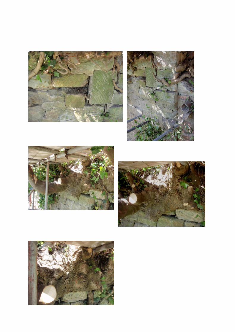
What had appeared from above as three separate trees is, in fact, just one, which has grown out of the
quay and expanded horizontally as well as vertically. The ‘trunk’ mass measures some 3 metres long by 1
metre high; it has wrapped itself around the stones at the top of the quay and its roots have penetrated
and expanded in the joints of the stonework at the upper level of the wall beyond the trunk mass.
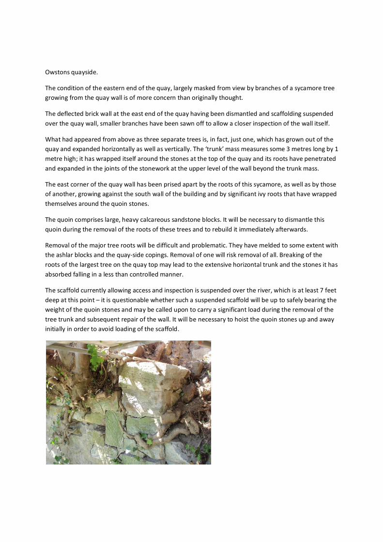
The east corner of the quay wall has been prised apart by the roots of this sycamore, as well as by those
of another, growing against the south wall of the building and by significant ivy roots that have wrapped
themselves around the quoin stones.
The quoin comprises large, heavy calcareous sandstone blocks. It will be necessary to dismantle this
quoin during the removal of the roots of these trees and to rebuild it immediately afterwards.
Removal of the major tree roots will be difficult and problematic. They have melded to some extent with
the ashlar blocks and the quay-side copings. Removal of one will risk removal of all. Breaking of the
roots of the largest tree on the quay top may lead to the extensive horizontal trunk and the stones it has
absorbed falling in a less than controlled manner.
The scaffold currently allowing access and inspection is suspended over the river, which is at least 7 feet
deep at this point – it is questionable whether such a suspended scaffold will be up to safely bearing the
weight of the quoin stones and may be called upon to carry a significant load during the removal of the
tree trunk and subsequent repair of the wall. It will be necessary to hoist the quoin stones up and away
initially in order to avoid loading of the scaffold.


Owstons Warehouse Quayside, supplementary notes
As detailed upon the 1850 Ordnance Survey map, the riverbank steps in to the east of Owstons
Warehouse and its quay. A little further to the east, there is a flight of steps giving riverside loading and
unloading access to another building which at this time would seem to have been in distinct ownership
or tenancy to Owstons itself. The building that was served by these steps has now gone.
Clearance of overhanging ivy to the east of Owstons has allowed some inspection of this area which is
currently some four feet below the level of the yard to the north of Owstons, below a concrete block
wall which abuts the east elevation of the warehouse at its mid-way point.
The opening for the steps survives. It has been infilled in the past, apparently with soil and this has
spilled somewhat into the river. Between Owstons quay and the opening for these steps, the wall is of
typically C19 brickwork, laid or at least pointed with a pale cementitious mortar. The same mortar
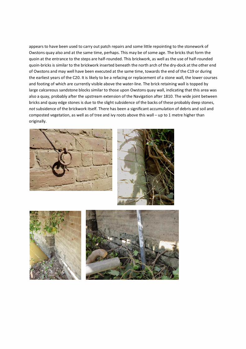
appears to have been used to carry out patch repairs and some little repointing to the stonework of
Owstons quay also and at the same time, perhaps. This may be of some age. The bricks that form the
quoin at the entrance to the steps are half-rounded. This brickwork, as well as the use of half-rounded
quoin-bricks is similar to the brickwork inserted beneath the north arch of the dry-dock at the other end
of Owstons and may well have been executed at the same time, towards the end of the C19 or during
the earliest years of the C20. It is likely to be a refacing or replacement of a stone wall, the lower courses
and footing of which are currently visible above the water-line. The brick retaining wall is topped by
large calcareous sandstone blocks similar to those upon Owstons quay wall, indicating that this area was
also a quay, probably after the upstream extension of the Navigation after 1810. The wide joint between
bricks and quay edge stones is due to the slight subsidence of the backs of these probably deep stones,
not subsidence of the brickwork itself. There has been a significant accumulation of debris and soil and
composted vegetation, as well as of tree and ivy roots above this wall – up to 1 metre higher than
originally.

There is a sizable sycamore tree growing in the infill material of the steps. The probably stone steps
themselves may be expected to remain in situ beneath the infill material.
The eastern quoin of the steps opening is formed of roughly 12” high blocks of calcareous sandstone.
Like the wall itself, these are in a generally sound condition. This wall also is topped with large edging
stones consistent with this area having served as another quay alongside that of Owstons and at a
somewhat lower level.
If ground levels to the north and east of Owstons Warehouse are returned to their earlier location, the
concrete wall above this easterly quay area would be removed. The stone quayside and steps here, too,
might be readily regained.
NC 02.06.09

Owstons Dry-dock survey.
Removal of scaffold-boards in place since the beginning of the job, as well as the low summer levels of
the river and the clearance of vegetation, have allowed a close inspection of the dry-dock area for the
first time. It is in variable condition.
In places, there has been extensive delamination of the calcareous sandstone ashlar blocks of which the
lower walls of the dry-dock area are constructed. In places, particularly to the riverside returns of the
wall to either side of the steps, blocks have simply fallen away, leaving other blocks cantilevering above
them. In places, tree roots from large sycamore trees above and on the edge of the former quays to
either side have lifted and partially enveloped whole stones as well as pushing out stones below.
Delamination and crumbling, east of west wall
within dry-dock
Tree roots and trunk at top of this section

West of east wall inside dry-dock – essentially sound,
needing repointing only; upper two stones of quoin being
forced sideways by tree roots.
However, the overall condition of the quay walls is remarkably good, given their almost certain
construction around 1725.
Logistically, the repair of these sections of wall will be problematic.
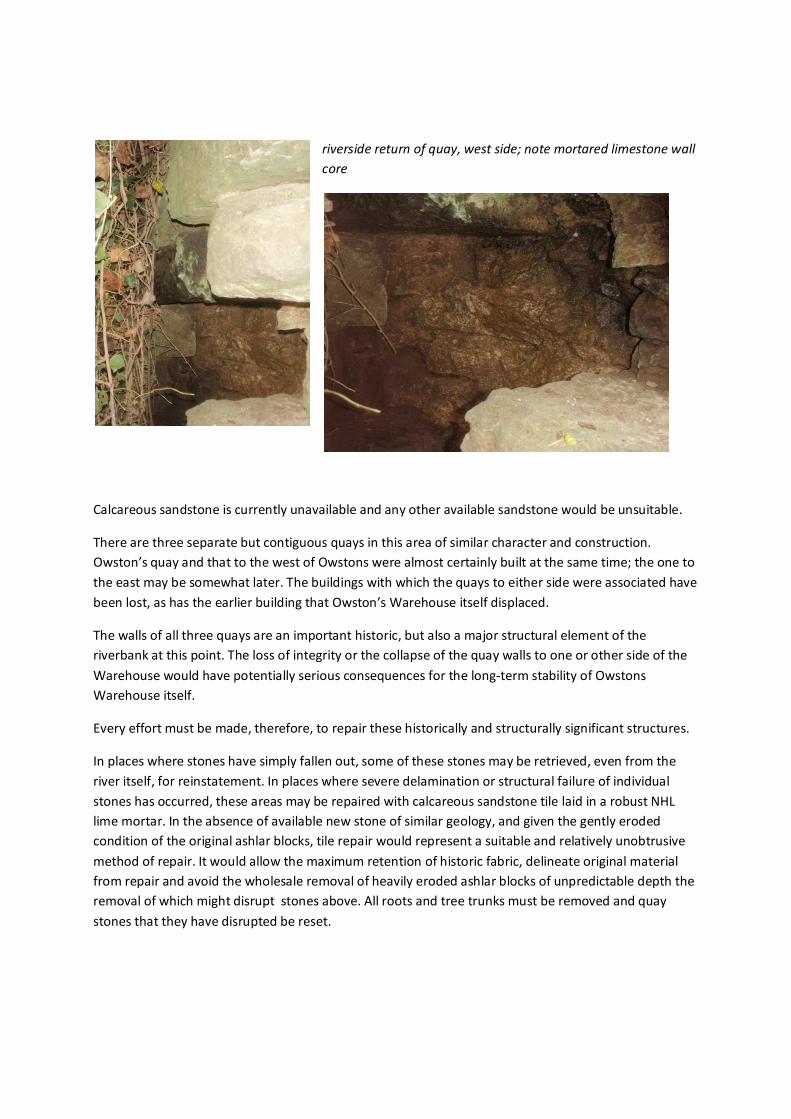
riverside return of quay, west side; note mortared limestone wall
core
Calcareous sandstone is currently unavailable and any other available sandstone would be unsuitable.
There are three separate but contiguous quays in this area of similar character and construction.
Owston’s quay and that to the west of Owstons were almost certainly built at the same time; the one to
the east may be somewhat later. The buildings with which the quays to either side were associated have
been lost, as has the earlier building that Owston’s Warehouse itself displaced.
The walls of all three quays are an important historic, but also a major structural element of the
riverbank at this point. The loss of integrity or the collapse of the quay walls to one or other side of the
Warehouse would have potentially serious consequences for the long-term stability of Owstons
Warehouse itself.
Every effort must be made, therefore, to repair these historically and structurally significant structures.
In places where stones have simply fallen out, some of these stones may be retrieved, even from the
river itself, for reinstatement. In places where severe delamination or structural failure of individual
stones has occurred, these areas may be repaired with calcareous sandstone tile laid in a robust NHL
lime mortar. In the absence of available new stone of similar geology, and given the gently eroded
condition of the original ashlar blocks, tile repair would represent a suitable and relatively unobtrusive
method of repair. It would allow the maximum retention of historic fabric, delineate original material
from repair and avoid the wholesale removal of heavily eroded ashlar blocks of unpredictable depth the
removal of which might disrupt stones above. All roots and tree trunks must be removed and quay
stones that they have disrupted be reset.

Where the facing has been lost beyond the west quoin of the dry-dock, the internal structure of the
quay walls is visible. This will almost certainly be the same as the internal structure of Owston’s
Warehouse quay itself: the large calcareous sandstone ashlar blocks face up a secondary ‘wall’ and core
of carefully laid limestone rubble, its units also of significant dimension and lime mortared. This explains
the general stability and good condition of the quays in this area which have only been disrupted by the
intrusion, jacking and leverage of significant tree-roots.
mouth of drain
structure of drain: stone ashlar
at wall-face; brick lining; stone
slab top.
Note intrusion of tree-roots
There is a formed drain from the rainwater goods of Owston’s west end which exits through the quay
wall via a carved stone. The drain is brick-built.

In the dry-dock area, at least, the logical sequence of works will be to complete repair and consolidation
at the lower levels before tackling the removal of tree roots above and the resetting of disrupted quay
edge stones. Lime should be French NHL 3.5.
Nigel Copsey 08.07.2009.
Removal of the tree root proved to be arduous and time-consuming.
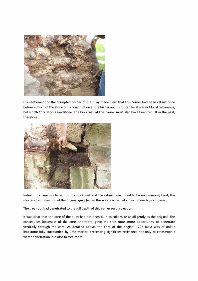
Dismantlement of the disrupted corner of the quay made clear that this corner had been rebuilt once
before – much of the stone of its construction at the higher and disrupted level was not local calcareous,
but North York Moors sandstone. The brick wall at this corner must also have been rebuilt in the past,
therefore.
Indeed, the lime mortar within the brick wall and the rebuild was found to be uncommonly hard; the
mortar of construction of the original quay (when this was reached) of a much more typical strength.
The tree root had penetrated to the full depth of this earlier reconstruction.
It was clear that the core of the quay had not been built as solidly, or as diligently as the original. The
consequent looseness of the core, therefore, gave the tree roots more opportunity to penetrate
vertically through the core. As detailed above, the core of the original 1725 build was of oolitic
limestone fully surrounded by lime mortar, presenting significant resistance not only to catastrophic
water penetration, but also to tree roots.

Further along the quay, where another large tree trunk remains, the wall is disrupted, stones have been
lost into the river, but the core is solid, the root penetration vertically less severe, it is to be hoped.
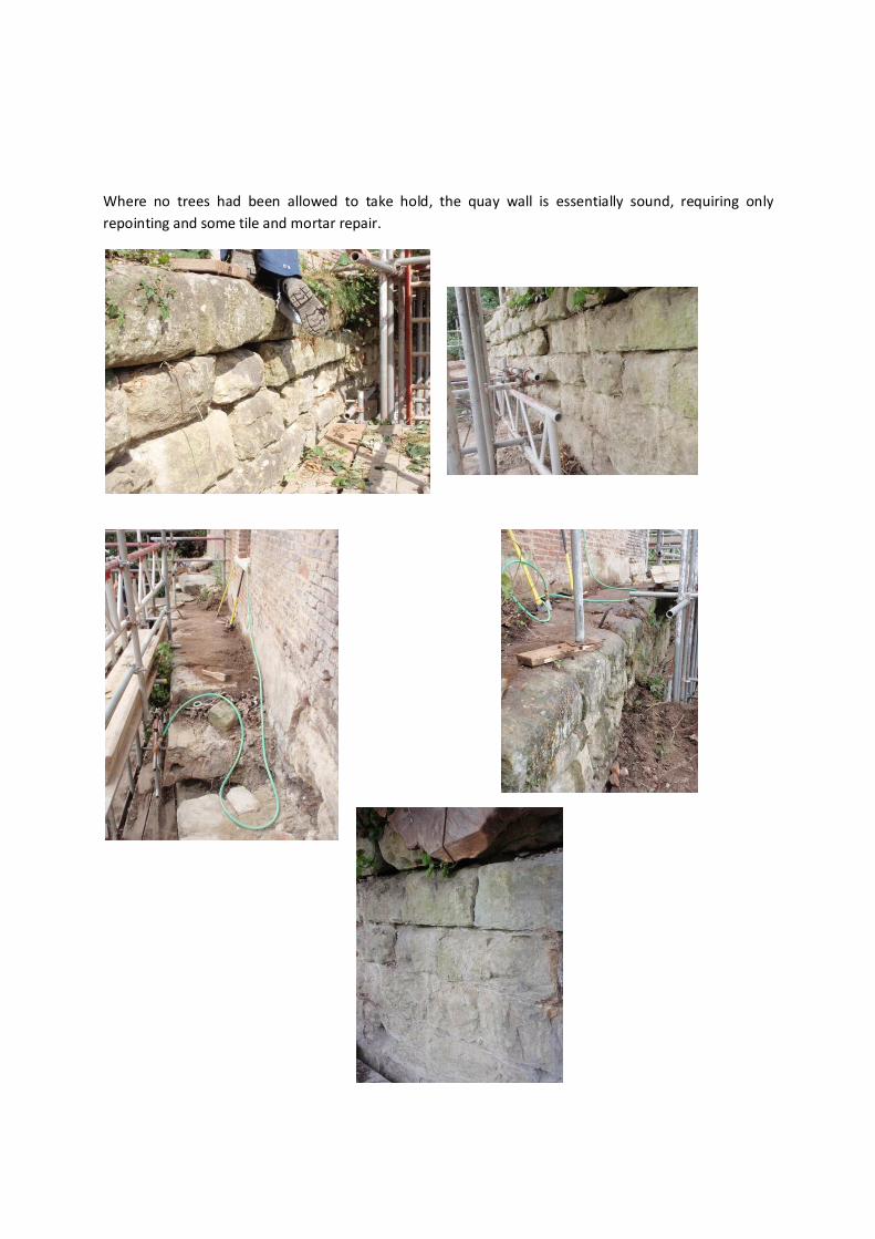
Where no trees had been allowed to take hold, the quay wall is essentially sound, requiring only
repointing and some tile and mortar repair.

Repair of the east end of the quay proceeded upon removal of all but the vestiges of the tree root; the
urgency of this repair informed by concern that the river levels beginning to rise at this time of year
would either prevent consolidation of the quay or worse, in flood. Wash out the footing of the
warehouse.
Original calcareous sandstone and jurassic sandstone blocks from the earlier repair were reused and
coursing was matched to the original coursing pattern of the quay. Some of the latter blocks had been
higher than the originals, disrupting the coursing and reducing the bond of the repair with the original
wall. These stones were dressed down to avoid this and to achieve maximum attachment between the
original material and the current repair. Heavily eroded original stones were turned where necessary to
utilise a better available face. New stones were also used – four blocks of Woodkirk sandstone and
others from the North York Moors, newly quarried. All new stones were tooled as per histroic local
practice and by reference to small survivng examples of original tooling on the quay.

The core of the wall was built up behind each course in turn, of well-mortared limestone and sandstone
rubble. This was extended into any voids within the footing of the warehouse.
Three new coping stones will be required. These will be of Aislaby sandstone. The original quay copings
are of local calcareous sandstone.
Mortar was 2 parts (wykeham) sharp sand to 1 part NHL 3.5 at lower levels of the repair; 3 parts sharp
sand to 1 part oolitic limestone dust to 2 parts NHL 2.0 to higher levels. Repointing will be 3 parts sharp
sand to 1 part limestone dust to 2 parts NHL 2.0. All NHL, Singleton Birch.

Investigation of the loose brickwork above the newly reinstated brick wall at the eastern corner of the
warehouse showed that this looseness extended to three bricks depth into the wall, which also
contained significant volumes of decomposed timber, bird’s and rodent’s nests. There was little mortar
binding. The lack of bond within this section of wall was of long-standing. The area was consolidated to
full depth once more and repointed. The decomposed timber was probably associated with a roofing
arrangement above and against the stub wall. At the end of a deliberate rebate which may have held a
small roof, there was also a formed socket, three bricks deep which probably held a projecting timber
which will have cantilevered from the building, supporting this roof. This socket was filled and faced
with clay tiles, as a marker.

Repair to the section of the quay further west will proceed upon removal of the tree stump and root at
this point.
The core remains substantially intact, however, and requires refacing with ashlar. The reopening of
Brows quarry – from which the stone for the quay was originally extracted - still having not been
granted, these repairs will of necessity be executed in jurassic sandstone from Aislaby. This is not ideal,
although the weathered stone in this location will look little different to the original. The works must be
completed before the river floods, however, and the scaffold will be vulnerable to destruction or
disturbance by any flooding. It is to be hoped that further essential repairs to either side of the dry-dock
may be executed next summer using stone from Brows Quarry.

Core of quay after removal of tree stump and root. This was, as hoped, of limited penetration into the
solidly constructed core, having grown between this and the coping stones only.
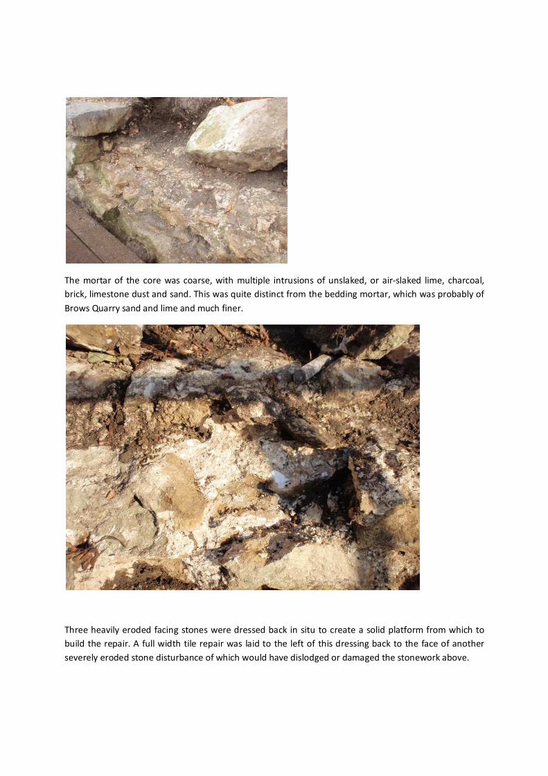
The mortar of the core was coarse, with multiple intrusions of unslaked, or air-slaked lime, charcoal,
brick, limestone dust and sand. This was quite distinct from the bedding mortar, which was probably of
Brows Quarry sand and lime and much finer.
Three heavily eroded facing stones were dressed back in situ to create a solid platform from which to
build the repair. A full width tile repair was laid to the left of this dressing back to the face of another
severely eroded stone disturbance of which would have dislodged or damaged the stonework above.
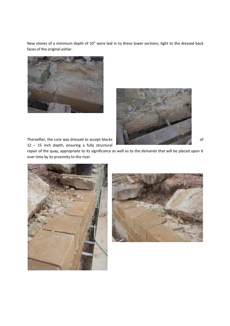
New stones of a minimum depth of 10” were laid in to these lower sections, tight to the dressed back
faces of the original ashlar.
Thereafter, the core was dressed to accept blocks of
12 – 15 inch depth, ensuring a fully structural
repair of the quay, appropriate to its significance as well as to the demands that will be placed upon it
over time by its proximity to the river.
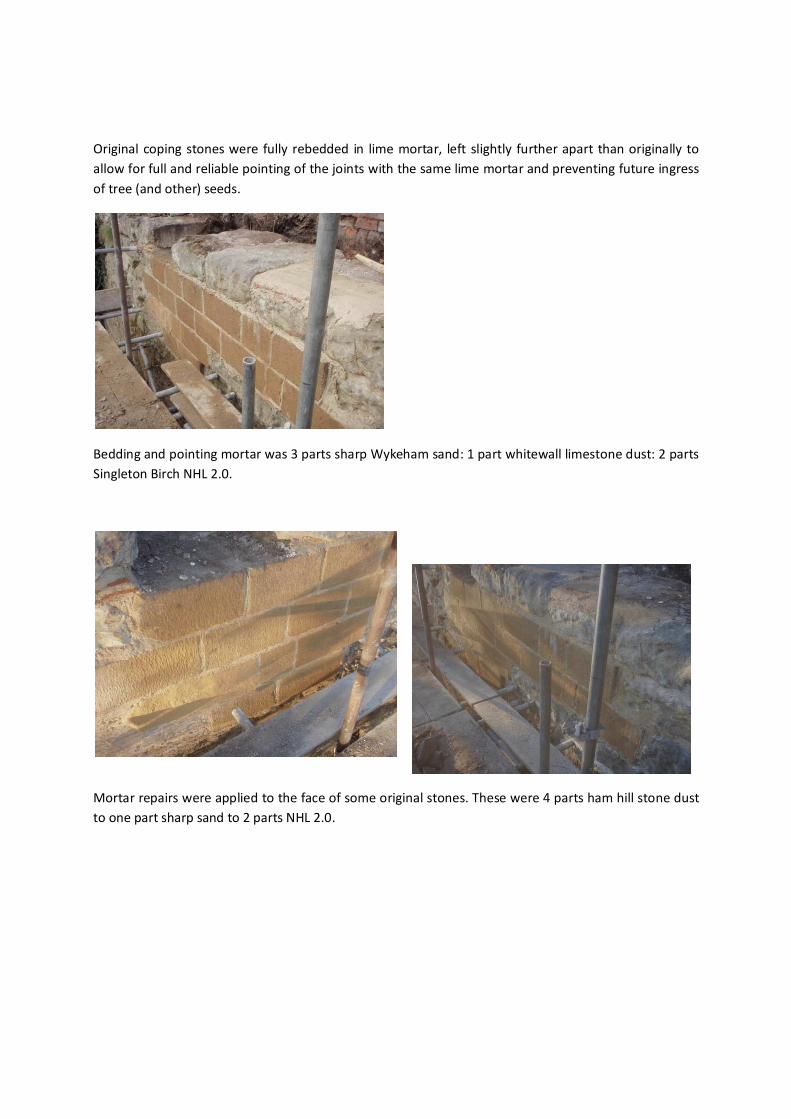
Original coping stones were fully rebedded in lime mortar, left slightly further apart than originally to
allow for full and reliable pointing of the joints with the same lime mortar and preventing future ingress
of tree (and other) seeds.
Bedding and pointing mortar was 3 parts sharp Wykeham sand: 1 part whitewall limestone dust: 2 parts
Singleton Birch NHL 2.0.
Mortar repairs were applied to the face of some original stones. These were 4 parts ham hill stone dust
to one part sharp sand to 2 parts NHL 2.0.
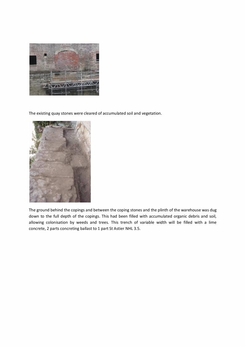
The existing quay stones were cleared of accumulated soil and vegetation.
The ground behind the copings and between the coping stones and the plinth of the warehouse was dug
down to the full depth of the copings. This had been filled with accumulated organic debris and soil,
allowing colonisation by weeds and trees. This trench of variable width will be filled with a lime
concrete, 2 parts concreting ballast to 1 part St Astier NHL 3.5.

To the east end of the quay, roots from the removed tree stump were chased along the quay where
these extended beneath and had lifted quay copings. Copings were lifted off and reset upon removal of
the roots.

Here and there, tree roots had established themselves within the quay coping stones, exploiting natural
bedding planes and splitting open the stone.
Similarly, tree and ivy roots had penetrated behind the hard opc render applied in the more recent past
– and at variable depth – to the stone plinth of the warehouse. The current intention is that this
unpredictably deep render should be left in situ. However, wherever tree roots can be seen to have
penetrated, this render will be removed and repairs to the plinth carried out before re-rendering with a
lime mortar of similar colour to the original calcareous sandstone of the plinth.

Upon completion of coping and repair works to this section of the quay, scaffolding will be moved to
allow repair of the quay to either side of the dry dock.

To the right hand side, stones have been lost or severely eroded at the lower level, undermining the
sound stonework above. A sycamore seedling has grown in the first joint of the coping, shunting the
corner coping progressively westward.
The corner will need to be dismantled; the stump and associated roots chopped out and the corner
rebuilt, stones replaced as necessary to the same bed-height and joint pattern.
The quay wall as a whole, between the current extent of scaffolding and the corner, will be repaired and
repointed as necessary.

To the left hand side of the opening, a large patch of ashlar is missing, exposing the core (see above).
The ashlar facing will be reinstated to full, structural depth.
A section of the west wall of the ‘dry-dock’ has been lost to leverage from the roots of a large sycamore
tree above, as well as to delamination of stones by fine root penetration of bedding planes and flaws in
the individual blocks. This too will be refaced to a minimum depth of 9”. The large tree stump and roots
will first be removed.