Embed Size (px)
Citation preview
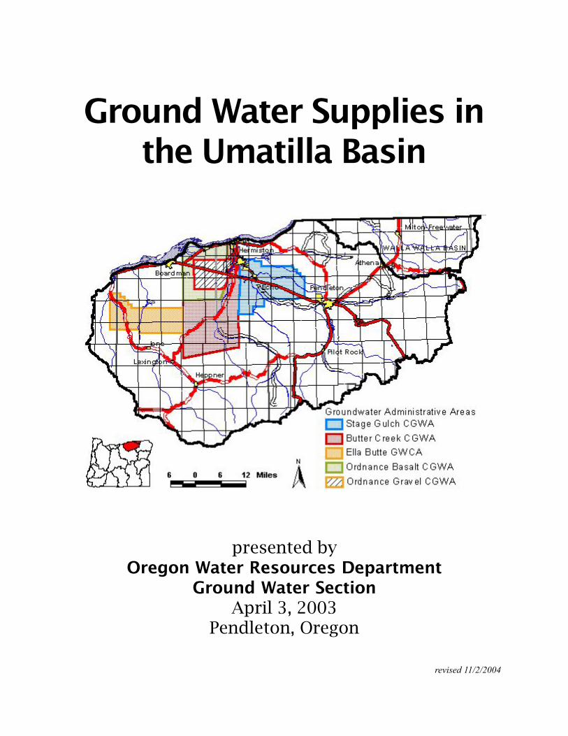
Ground Water Supplies inthe Umatilla Basin
presented byOregon Water Resources Department
Ground Water SectionApril 3, 2003
Pendleton, Oregon
revised 11/2/2004
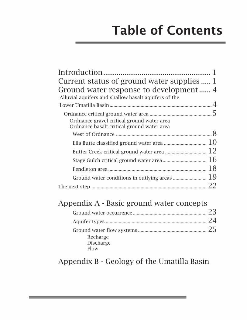
Table of Contents
Introduction........................................................ 1Current status of ground water supplies ..... 1Ground water response to development ...... 4 Alluvial aquifers and shallow basalt aquifers of the
Lower Umatilla Basin ...............................................................................4 Ordnance critical ground water area ................................................5 Ordnance gravel critical ground water area Ordnance basalt critical ground water area
West of Ordnance ..........................................................................8Ella Butte classified ground water area ................................. 10Butter Creek critical ground water area ................................ 12Stage Gulch critical ground water area .................................. 16Pendleton area ............................................................................ 18Ground water conditions in outlying areas .......................... 19
The next step ......................................................................................... 22
Appendix A - Basic ground water conceptsGround water occurrence ......................................................... 23Aquifer types .............................................................................. 24Ground water flow systems ..................................................... 25
RechargeDischargeFlow
Appendix B - Geology of the Umatilla Basin
Oregon Water Resources Department April 3, 2003 1
GROUND WATER SUPPLIES IN THE UMATILLA BASIN
Introduction
Virtually every economic venture in the Umatilla Basin relies on adependable water supply. Water is essential to farming and dairy operation,power generation, food processing and a variety of other industrial andcommercial endeavors. Water is also essential for municipal expansion aswell as rural residential development.
New appropriations of water from surface water sources in the UmatillaBasin are restricted or limited by available supplies or endangered andthreatened species concerns. New water supplies from existing storagereservoirs and artificial recharge projects are also not currently available.Consequently, ground water is the logical alternative for meeting new watersupply demands.
Oregon ground water statutes require that the Water Resources Commissionand Water Resources Department manage ground water as a renewableresource. Overdraft, excessive water level declines, unstable water levels,and substantial interference with senior rights are to be prevented.Continued economic growth reliant on ground water supplies is unrealisticgiven these water management objectives. If the Basin is to continuegrowing, some very difficult decisions will have to be made relative to waterresource management in the Basin. To be effective, those decisions need tobe based on a thorough understanding of the conjoined ground water/surface water system. A comprehensive Basin—wide ground water study isbeing planned to provide the necessary understanding.
This report provides a synopsis of our current understanding of groundwater resources in areas of the Umatilla Basin. Appendices to the reportprovide background information on ground water concepts (Appendix A)and the geology of the Umatilla Basin (Appendix B).
Ground Water Supplies in the Umatilla Basin2
CURRENT STATUS OF GROUND WATER SUPPLIESIN THE BASIN
Since the late 1960s, it has been apparent that development and manage-ment of ground water resources in the Umatilla Basin would require carefulattention. Overdraft, unstable water levels, excessive declines, and otherground water problems exist or are developing in the basin.
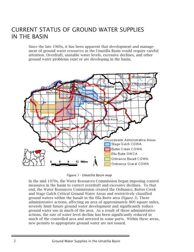
In the mid 1970s, the Water Resources Commission began imposing controlmeasures in the basin to correct overdraft and excessive declines. To thatend, the Water Resources Commission created the Ordnance, Butter Creekand Stage Gulch Critical Ground Water Areas and restrictively classifiedground waters within the basalt in the Ella Butte area (Figure 1). Theseadministrative actions, affecting an area of approximately 800 square miles,severely limit future ground water development and significantly reduceground water use in much of the area. As a result of these administrativeactions, the rate of water level decline has been significantly reduced inmuch of the controlled area and arrested in some parts. Within these areas,new permits to appropriate ground water are not issued.
Figure 1 - Umatilla Basin map
Oregon Water Resources Department April 3, 2003 3
Ground water overdraft continues to be a significant issue in the UmatillaBasin. Declines in ground water levels are evident in areas outside of thecontrolled areas and, to some extent, within the controlled areas. Thesedeclines are focused in and around the cities of Boardman, Adams, Athena,and Pendleton. In addition, declines persist within the Ella Butte andOrdnance areas and within parts of the Stage Gulch and Butter CreekCritical areas. This ground water instability is likely to be an indicator ofoverdraft. A ground water investigation conducted in the early 1980ssuggested that ground water throughout the basin was already overdraftedat that time. This would suggest that some of the more recent economicdevelopment dependent upon ground water is in jeopardy and that newground water-dependent economic development is unwise.
In addition to overdraft concerns, interference between ground water usersis a significant issue inthe Umatilla Basin.Users of the groundwater resource are notisolated one fromanother. As one wateruser pumps waterfrom the aquifer, waterlevels decline inresponse. Thosedeclines cause lowerwater levels for otherground water appro-priators using thesame source. Thisphenomenon is called interference. Interference causes increased pumpinglifts and increased costs for other users of the resource. In the more severecases of interference, some users may not be able to pump enough water tosatisfy their water rights.
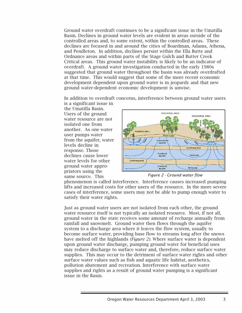
Just as ground water users are not isolated from each other, the groundwater resource itself is not typically an isolated resource. Most, if not all,ground water in the state receives some amount of recharge annually fromrainfall and snowmelt. Ground water then flows through the aquifersystem to a discharge area where it leaves the flow system, usually tobecome surface water, providing base flow to streams long after the snowshave melted off the highlands (Figure 2). Where surface water is dependentupon ground water discharge, pumping ground water for beneficial usesmay reduce discharge to surface water and, therefore, reduce surface watersupplies. This may occur to the detriment of surface water rights and othersurface water values such as fish and aquatic life habitat, aesthetics,pollution abatement and recreation. Interference with surface watersupplies and rights as a result of ground water pumping is a significantissue in the Basin.
Figure 2 - Ground water flow
Ground Water Supplies in the Umatilla Basin4
GROUND WATER RESPONSE TO DEVELOPMENT
Ground water levels are declining in areas throughout the Umatilla Basin,further highlighting the need for a basin-wide, comprehensive understand-ing of ground water resources. The following sections present our currentknowledge of ground water supplies in areas of the Umatilla Basin. Anunderstanding of ground water occurrence and supply problems within thebasin will be improved by a brief introduction to ground water conceptswhich is provided in Appendix A.
Alluvial Aquifers and Shallow Basalt Aquifers of the LowerUmatilla Basin
A shallow unconfined aquifer occurs in the alluvial sediments of the lowerUmatilla Basin. Multiple confined aquifers occur in the underlying basaltflows. The alluvial and shallowest basalt aquifers are the main sources ofdomestic water for rural residents in the area. The alluvial aquifer is also amajor source of municipal water for the cities of Hermiston, Irrigon, andBoardman and an important source of irrigation water in the area betweenBoardman and Hermiston.
The main source of recharge to the alluvial aquifer comes from leaky canalsand ditches. Additional recharge comes from applied irrigation water. Inlocal areas, leakage from reservoirs and streams represents a significantcomponent of recharge. Recharge from precipitation is a relatively smallproportion of total recharge.
The principal water-producing zones of the alluvial aquifer in the lowerUmatilla Basin occur in deposits of coarse sand and gravel that fill threeeast- to northeast-trending shallow troughs between Boardman and ColdSprings Reservoir. Well yields in these areas commonly exceed 1000 gallonsper minute. However, ground water supplies are limited by the restrictedaerial extent of the deposits. In the Ordnance area (discussed later in thisreport), excessive pumpage from the gravels led to water-level declines thatrequired administrative restrictions on pumping. Water-level declines areunlikely in the gravels in the Boardman area as pumping will be buffered bycapture of water from the Columbia River.
Regional flow in the alluvial aquifer is to the northwest with discharge tothe Umatilla and Columbia rivers; however, flow directions vary consider-ably over space and time. The topography of the underlying basalt,seasonal pumping of high-capacity wells, and seasonal recharge from leakycanals are the main factors influencing flow direction. Seasonal reversals offlow are known to occur beneath the southern half of the UmatillaOrdnance Depot and may occur elsewhere.
The Umatilla River is hydraulically connected to the alluvial aquifer betweenthe cities of Echo and Umatilla where the river is in contact with alluvialsediments. At Butter Creek, the river begins to progressively downcut
Oregon Water Resources Department April 3, 2003 5
through the aquifer until it reaches basalt bedrock at Three-Mile Dam.These relationships suggest that natural discharge from the aquifer to theriver occurs between Butter Creek and Three-Mile Dam. This is consistentwith the known occurrence of natural springs in the lower reaches of theriver. However, good estimates of the amount of interchange between theriver and the aquifer are lacking.
Outside of the Umatilla lowlands, productive deposits of sand and gravelalso occur in the narrow floodplains of the mainstem Umatilla River andsome of its larger tributaries. These deposits typically occupy river valleysthat are incised into the basalt bedrock. Ground water in these sediments ishydraulically connected to the adjacent streams and withdrawing it inter-feres with streamflow.
Productive water-bearing zones within Columbia River Basalt flows aregenerally limited to thin zones of broken or fractured rock at the top orbase of individual basalt flows. The dense interiors of flows are relativelyimpermeable and confine ground water to discrete tabular aquifers.However, the geometry of the shallow basalt aquifers in the lower basinindicates that they are hydraulically connected to the alluvial aquifer, theUmatilla River, and the Columbia River where permeable zones in thebasalts are exposed beneath the alluvial aquifer and in the beds of therivers. As with the alluvial aquifer, pumping water out of these shallowestbasalts interferes with stream flows.
Ordnance Critical Ground Water Areas
There are two critical ground water areas in the Ordnance area: theOrdnance Gravel Critical Ground Water Area and the Ordnance Basalt Criti-cal Ground Water Area. The Ordnance Basalt Critical Ground Water Area islocated west of Hermiston and includes 175 square miles of basalt aquifersnear the Umatilla Chemical Depot and Irrigon. It is partially overlapped bythe Ordnance Gravel Critical Ground Water Area that includes 82 squaremiles of alluvial aquifer in the Depot area. The controlling order for bothareas was issued in 1976 and prohibits the issuance of new ground waterrights. “Exempt uses” are allowed under the order. Exempt uses aresmaller uses exempt from the water right permitting requirement and aretherefore referred to as “exempt uses.” Exempt uses include single or groupdomestic use up to 15,000 gallons per day, noncommercial irrigation of upto one-half acre, stock watering, and commercial and industrial use up to5,000 gallons per day.
The stratigraphy for both areas can be generalized. Alluvial material ispresent from land surface to an average depth of 50 to 100 feet, attaining amaximum of about 200 feet. These materials vary spatially in thickness andcomposition but consist of sand, gravel, silt, and clay. These sediments areunderlain by lava flows of the Columbia River Basalt Group. These flows arenumerous and are not fully penetrated by local wells.
Ground Water Supplies in the Umatilla Basin6
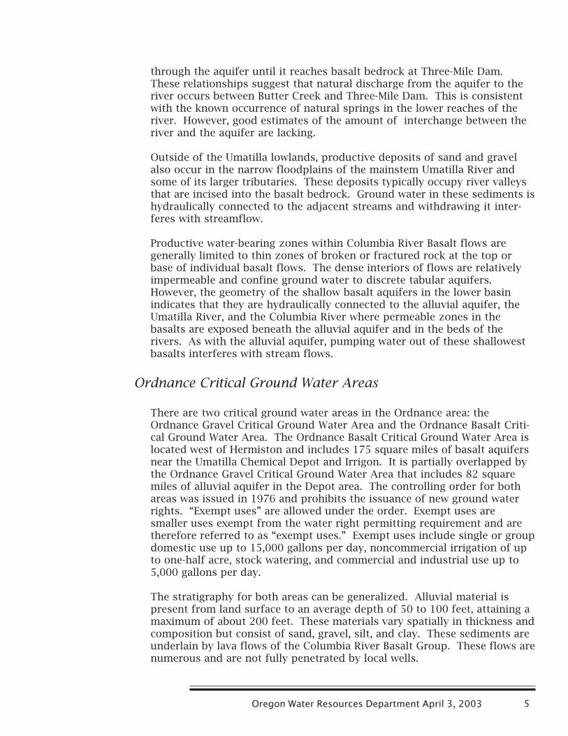
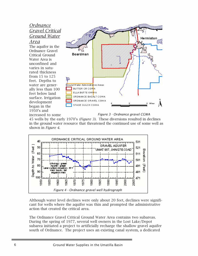
OrdnanceGravel CriticalGround WaterAreaThe aquifer in theOrdnance GravelCritical GroundWater Area isunconfined andvaries in satu-rated thicknessfrom 15 to 125feet. Depths towater are gener-ally less than 100feet below landsurface. Irrigationdevelopmentbegan in the1950’s andincreased to some45 wells by the early 1970’s (Figure 3). These diversions resulted in declinesin the ground water resource that threatened the continued use of some well asshown in Figure 4.
Although water level declines were only about 20 feet, declines were signifi-cant for wells where the aquifer was thin and prompted the administrativeaction that created the critical area.
The Ordnance Gravel Critical Ground Water Area contains two subareas.During the spring of 1977, several well owners in the Lost Lake/Depotsubarea initiated a project to artificially recharge the shallow gravel aquifersouth of Ordnance. The project uses an existing canal system, a dedicated
Figure 3 - Ordnance gravel CGWA
Figure 4 - Ordnance gravel well hydrograph
Oregon Water Resources Department April 3, 2003 7
leaky recharge canal, and winter/spring water from the Umatilla Riverdiverted near Echo. Water levels in many gravel wells have respondedfavorably. Historically, recharge has been at a rate of approximately 6000acre-feet per year. However, access to water for recharge has been reduced inrecent years in response to insufficient flows to meet instream water rights.Recharge amounts for the last four years have been less than 5000 acre-feetper year. This artificial recharge project is essential to stabilize aquiferlevels and supplement irrigation supplies.
Currently, water levels in the critical area are fairly stable. Water use underpermit remains high, and there is a slow, steady increase in exempt uses.Water levels in the critical area are better than in the mid-1970s prior torecharge project, but have dropped in recent years (Figure 4). More rechargeor less water use is needed to correct current water level trends.
Ordnance Basalt Critical Ground Water AreaThe administrative order for the Ordnance Basalt Critical Ground WaterArea defines two basalt aquifers (Figure 3). Aquifers less than 400 feet deepare termed the shallow basalt aquifer and those more than 400 feet deepare the deep basalt aquifer. Local development of these ground waterresources began in the 1940s at the Umatilla Army Depot (now, UmatillaChemical Depot). Ground water development continued and peaked nearcurrent levels in the 1960s. Use is now largely for irrigation but alsoincludes municipal use by the City of Irrigon and military purposes at theDepot.
There are several general differences between the shallow and deep basaltaquifers. In the critical area, the depth to water in deep basalt wells isgenerally about 300 feet while the depth in shallow basalt wells is less than150 feet below land surface. In addition, the shallow basalt is more readilyrecharged and is less productive, and has smaller declines. Ground water inthe shallow basalt aquifer is, at least in part, unconfined while the deepbasalts are confined. The shallow basalt aquifer does not display the uni-form water level response that the deep ones do. In these ways, the shallowbasalt aquifer acts more like an alluvial resource than the deep basalt and islikely hydraulically connected to the alluvial ground water.
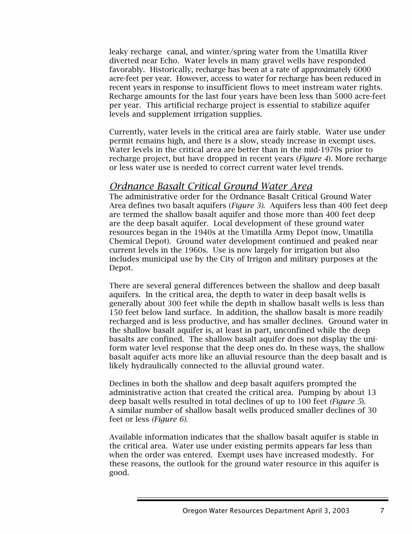
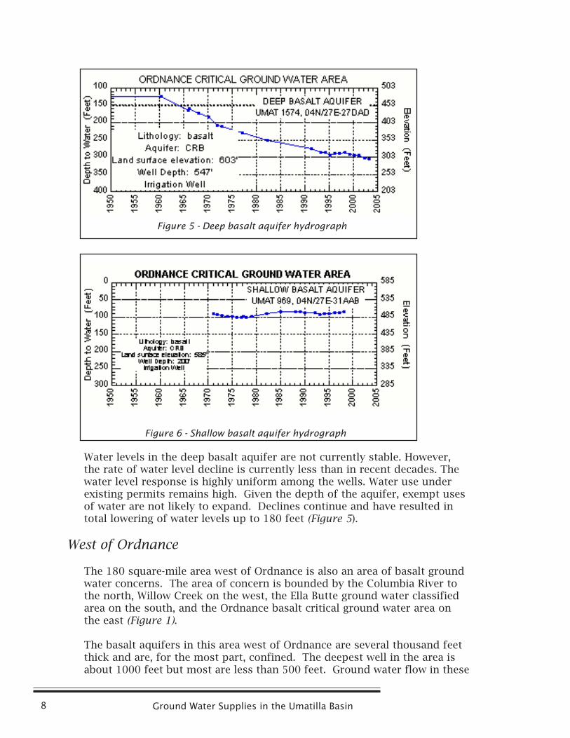
Declines in both the shallow and deep basalt aquifers prompted theadministrative action that created the critical area. Pumping by about 13deep basalt wells resulted in total declines of up to 100 feet (Figure 5).A similar number of shallow basalt wells produced smaller declines of 30feet or less (Figure 6).
Available information indicates that the shallow basalt aquifer is stable inthe critical area. Water use under existing permits appears far less thanwhen the order was entered. Exempt uses have increased modestly. Forthese reasons, the outlook for the ground water resource in this aquifer isgood.
Ground Water Supplies in the Umatilla Basin8
Water levels in the deep basalt aquifer are not currently stable. However,the rate of water level decline is currently less than in recent decades. Thewater level response is highly uniform among the wells. Water use underexisting permits remains high. Given the depth of the aquifer, exempt usesof water are not likely to expand. Declines continue and have resulted intotal lowering of water levels up to 180 feet (Figure 5).
West of Ordnance
The 180 square-mile area west of Ordnance is also an area of basalt groundwater concerns. The area of concern is bounded by the Columbia River tothe north, Willow Creek on the west, the Ella Butte ground water classifiedarea on the south, and the Ordnance basalt critical ground water area onthe east (Figure 1).
The basalt aquifers in this area west of Ordnance are several thousand feetthick and are, for the most part, confined. The deepest well in the area isabout 1000 feet but most are less than 500 feet. Ground water flow in these
Figure 5 - Deep basalt aquifer hydrograph
Figure 6 - Shallow basalt aquifer hydrograph
Oregon Water Resources Department April 3, 2003 9
aquifers is toward the Columbia River. Recharge is generally very low butthe presence of surface water from canal leakage and other artificialsources is locally important to shallow basalt aquifers.
As with all basalt aquifers, there is a vertical stratification that producesaquifers with different water levels (heads) with depth. Deeper wells at lowelevation have been capable of strong artesian pressures. Shallower wellshave water levels that vary but are usually less than 200 feet below landsurface. Basalt hydrology is complex and site-specific conditions can be morevariable than this generalization suggests. The distinction between shallow anddeep basalt aquifers in the area is difficult to make. As a generalization, thedeep basalts are considered to be those below about 400 feet below landsurface. Deeper aquifers have been more prone to decline with use. Deeperwells are often capable of yields in excess of 1000 gallons per minute whileshallower wells produce less.
Properly constructed wells do not commingle aquifers with different waterlevels. When wells commingle aquifers, they act to stress the aquifer notonly when pumping occurs, but also when the wells are not pumped, whichcan exacerbate any water level instability in the aquifers. Improper wellconstruction may be an issue in this area.
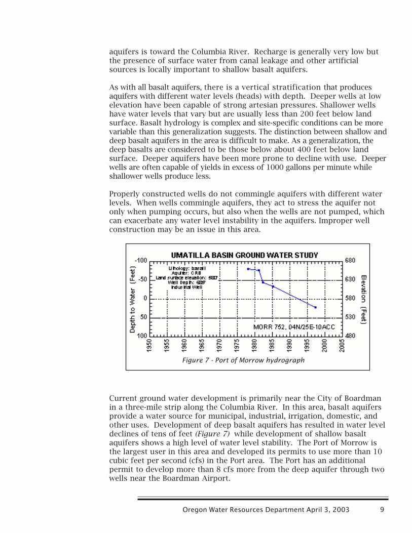
Current ground water development is primarily near the City of Boardmanin a three-mile strip along the Columbia River. In this area, basalt aquifersprovide a water source for municipal, industrial, irrigation, domestic, andother uses. Development of deep basalt aquifers has resulted in water leveldeclines of tens of feet (Figure 7) while development of shallow basaltaquifers shows a high level of water level stability. The Port of Morrow isthe largest user in this area and developed its permits to use more than 10cubic feet per second (cfs) in the Port area. The Port has an additionalpermit to develop more than 8 cfs more from the deep aquifer through twowells near the Boardman Airport.
Figure 7 - Port of Morrow hydrograph
Ground Water Supplies in the Umatilla Basin10
Ground water development outside of the Boardman area is minimal,although there is some industrial and irrigation uses. Water use permitswill allow about 3 cfs of new agricultural use for dairy operations in thecenter of the area.
Future demand on the basalt aquifer resource is uncertain. Current uses areexpected to continue and undeveloped permits will be developed. These willincrease the current demand and likely cause additional water level decline. Arecent application in the north-central part of the area seeks to divert 35 cfsthrough nine wells for irrigation. There is speculation that the BoardmanBombing Range is being phased out and that land may go into privatecontrol. Such changes could promote additional demand on the basaltground water resources in the eastern third of the area.
Ella Butte Classified Ground Water Area
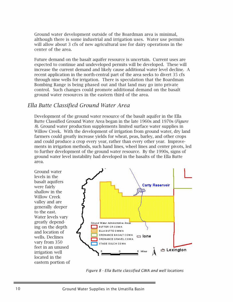
Development of the ground water resource of the basalt aquifer in the EllaButte Classified Ground Water Area began in the late 1960s and 1970s (Figure8). Ground water production supplements limited surface water supplies inWillow Creek. With the development of irrigation from ground water, dry landfarmers could greatly increase yields for wheat, peas, barley, and other cropsand could produce a crop every year, rather than every other year. Improve-ments in irrigation methods, such hand lines, wheel lines and center pivots, ledto further development of the ground water resource. By the 1990s, signs ofground water level instability had developed in the basalts of the Ella Buttearea.
Ground waterlevels in thebasalt aquiferswere fairlyshallow in theWillow Creekvalley and aregenerally deeperto the east.Water levels varygreatly depend-ing on the depthand location ofwells. Declinesvary from 350feet in an unusedirrigation welllocated in theeastern portion of
Figure 8 - Ella Butte classified GWA and well locations
Oregon Water Resources Department April 3, 2003 11
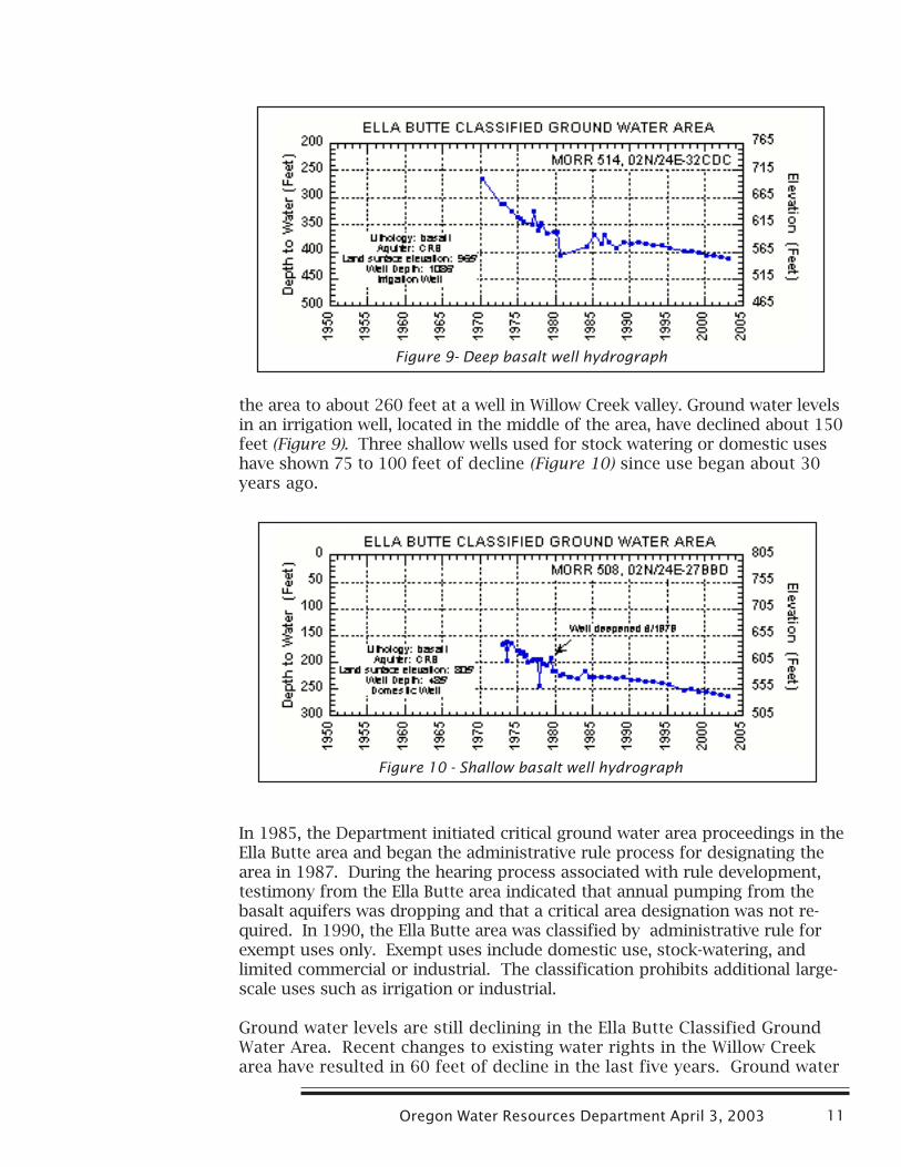
the area to about 260 feet at a well in Willow Creek valley. Ground water levelsin an irrigation well, located in the middle of the area, have declined about 150feet (Figure 9). Three shallow wells used for stock watering or domestic useshave shown 75 to 100 feet of decline (Figure 10) since use began about 30years ago.
In 1985, the Department initiated critical ground water area proceedings in theElla Butte area and began the administrative rule process for designating thearea in 1987. During the hearing process associated with rule development,testimony from the Ella Butte area indicated that annual pumping from thebasalt aquifers was dropping and that a critical area designation was not re-quired. In 1990, the Ella Butte area was classified by administrative rule forexempt uses only. Exempt uses include domestic use, stock-watering, andlimited commercial or industrial. The classification prohibits additional large-scale uses such as irrigation or industrial.
Ground water levels are still declining in the Ella Butte Classified GroundWater Area. Recent changes to existing water rights in the Willow Creekarea have resulted in 60 feet of decline in the last five years. Ground water
Figure 9- Deep basalt well hydrograph
Figure 10 - Shallow basalt well hydrograph
Ground Water Supplies in the Umatilla Basin12
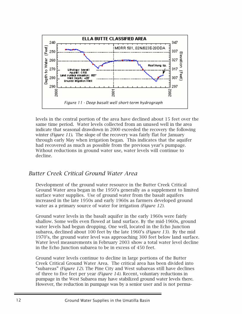
levels in the central portion of the area have declined about 15 feet over thesame time period. Water levels collected from an unused well in the areaindicate that seasonal drawdown in 2000 exceeded the recovery the followingwinter (Figure 11). The slope of the recovery was fairly flat for Januarythrough early May when irrigation began. This indicates that the aquiferhad recovered as much as possible from the previous year’s pumpage.Without reductions in ground water use, water levels will continue todecline.
Butter Creek Critical Ground Water Area
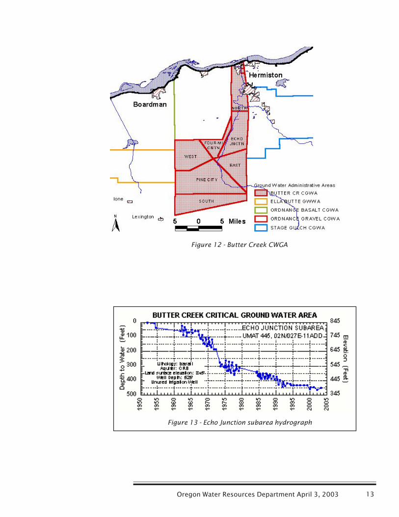
Development of the ground water resource in the Butter Creek CriticalGround Water area began in the 1950’s generally as a supplement to limitedsurface water supplies. Use of ground water from the basalt aquifersincreased in the late 1950s and early 1960s as farmers developed groundwater as a primary source of water for irrigation (Figure 12).
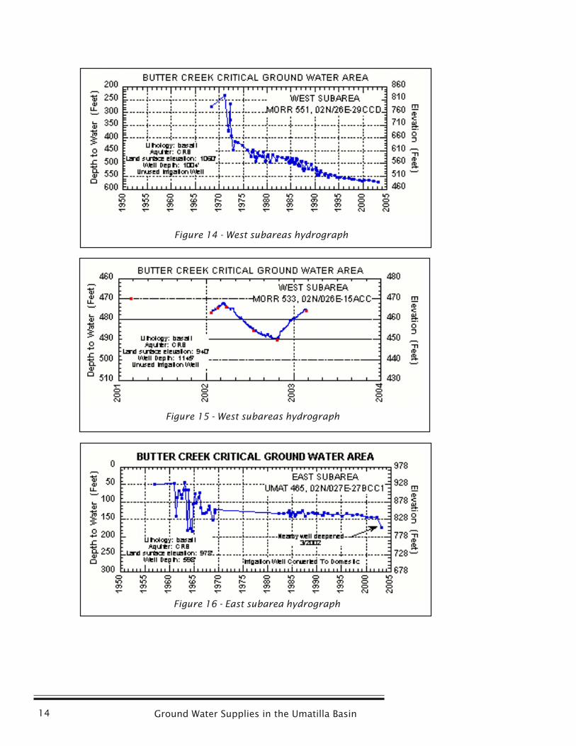
Ground water levels in the basalt aquifer in the early 1960s were fairlyshallow. Some wells even flowed at land surface. By the mid-1960s, groundwater levels had begun dropping. One well, located in the Echo Junctionsubarea, declined about 100 feet by the late 1960’s (Figure 13). By the mid1970’s, the ground water level was approaching 300 feet below land surface.Water level measurements in February 2003 show a total water level declinein the Echo Junction subarea to be in excess of 450 feet.
Ground water levels continue to decline in large portions of the ButterCreek Critical Ground Water Area. The critical area has been divided into“subareas” (Figure 12). The Pine City and West subareas still have declinesof three to five feet per year (Figure 14). Recent, voluntary reductions inpumpage in the West Subarea may have stabilized ground water levels there.However, the reduction in pumpage was by a senior user and is not perma-
Figure 11 - Deep basalt well short-term hydrograph
Oregon Water Resources Department April 3, 2003 13
Figure 13 - Echo Junction subarea hydrograph
Figure 12 - Butter Creek CWGA
Ground Water Supplies in the Umatilla Basin14
Figure 15 - West subareas hydrograph
Figure 16 - East subarea hydrograph
Figure 14 - West subareas hydrograph
Oregon Water Resources Department April 3, 2003 15
nent. A water level recorder was installed on an unused irrigation well in theWest Subarea (Figure 15). The water level in this area is still rising whenpumping begins in the spring, unlike the well in the Ella Butte area. If thewells were not started in the spring, ground water levels would continue torecovery from previous irrigation.
The North Subarea is also showing declines. All permitted uses, except the Cityof Umatilla, have been regulated off in the area. Water levels in the City ofUmatilla’s well have declined almost 50 feet. Domestic wells east of Hermistonhave declined about 150 feet over the last 45 years. Well construction andadditional new uses from domestic wells are also impacting ground waterlevels in theNorth Subarea.
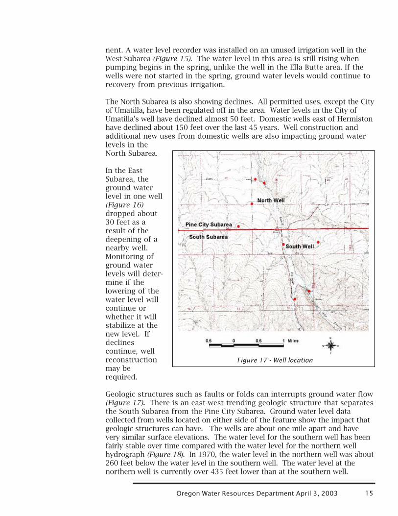
In the EastSubarea, theground waterlevel in one well(Figure 16)dropped about30 feet as aresult of thedeepening of anearby well.Monitoring ofground waterlevels will deter-mine if thelowering of thewater level willcontinue orwhether it willstabilize at thenew level. Ifdeclinescontinue, wellreconstructionmay berequired.
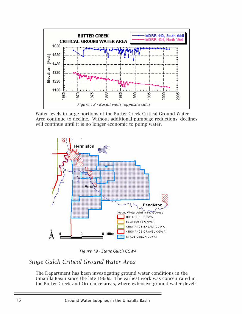
Geologic structures such as faults or folds can interrupts ground water flow(Figure 17). There is an east-west trending geologic structure that separatesthe South Subarea from the Pine City Subarea. Ground water level datacollected from wells located on either side of the feature show the impact thatgeologic structures can have. The wells are about one mile apart and havevery similar surface elevations. The water level for the southern well has beenfairly stable over time compared with the water level for the northern wellhydrograph (Figure 18). In 1970, the water level in the northern well was about260 feet below the water level in the southern well. The water level at thenorthern well is currently over 435 feet lower than at the southern well.
Figure 17 - Well location
Ground Water Supplies in the Umatilla Basin16
Figure 19 - Stage Gulch CGWA
Water levels in large portions of the Butter Creek Critical Ground WaterArea continue to decline. Without additional pumpage reductions, declineswill continue until it is no longer economic to pump water.
Stage Gulch Critical Ground Water Area
The Department has been investigating ground water conditions in theUmatilla Basin since the late 1960s. The earliest work was concentrated inthe Butter Creek and Ordnance areas, where extensive ground water devel-
Figure 18 - Basalt wells: opposite sides
Oregon Water Resources Department April 3, 2003 17
opment, primarily for irrigation, first occurred. As additional developmentof ground water progressed through the 1970s in areas to the east and westof the Butter Creek and Ordnance areas, the scope of the Department’sinvestigation expanded to include those areas. By the mid 1980s, it wasclear that the same problems that had been documented in Butter Creek andOrdnance were occurring in these more recently developed areas.
The Stage Gulch Critical Area to the east of the Butter Creek area (Figure 1) wasestablished in 1991 to address three issues developing in the confined basaltaquifers. These issues included excessive ground water level declines, substan-tial interference between wells, and overdraft of the ground water resource.
The Stage Gulch Critical Ground Water Area includes approximately 183 squaremiles (Figure 19). Over 100 permitted basalt wells are located within the area.
These wells are authorized for primary and supplemental irrigation of over25,000 acres, municipal use for the cities of Hermiston, Stanfield and Echo andsome industrial and manufacturing uses. The critical area is divided into eightsubareas, each of which is managed separately.
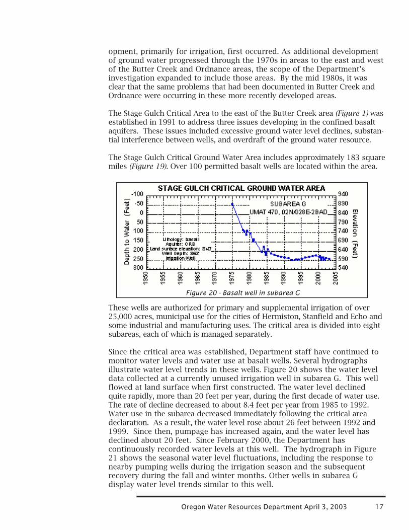
Since the critical area was established, Department staff have continued tomonitor water levels and water use at basalt wells. Several hydrographsillustrate water level trends in these wells. Figure 20 shows the water leveldata collected at a currently unused irrigation well in subarea G. This wellflowed at land surface when first constructed. The water level declinedquite rapidly, more than 20 feet per year, during the first decade of water use.The rate of decline decreased to about 8.4 feet per year from 1985 to 1992.Water use in the subarea decreased immediately following the critical areadeclaration. As a result, the water level rose about 26 feet between 1992 and1999. Since then, pumpage has increased again, and the water level hasdeclined about 20 feet. Since February 2000, the Department hascontinuously recorded water levels at this well. The hydrograph in Figure21 shows the seasonal water level fluctuations, including the response tonearby pumping wells during the irrigation season and the subsequentrecovery during the fall and winter months. Other wells in subarea Gdisplay water level trends similar to this well.
Figure 20 - Basalt well in subarea G

Ground Water Supplies in the Umatilla Basin18
Wells in other subareas exhibit trends generally indicating water levels havenot stabilized since the critical area was designated. Water levels continueto decline, but at a lower rate, following establishment of the critical area.Figure 22 is a hydrograph for an irrigation well within subarea H. Waterlevels at wells in this subarea declined about 2.5 to 4.5 feet per year inrecent years. Data from the area generally suggest that, without furtherreductions in ground water use, water levels will continue to decline until it isno longer an economic source of water.
Pendleton Area
The City of Pendleton currently uses a combination of surface and groundwater sources for municipal purposes. The proportion of the city’s totalwater supply that comes from ground water is increasing. Eventually, theCity is seeking authorization to develop up to 13 wells tapping the deepconfined basalt aquifer.
Figure 22 - Basalt well in subarea H
Figure 21 - Short-term hydrograph of basalt well insubarea G
Oregon Water Resources Department April 3, 2003 19
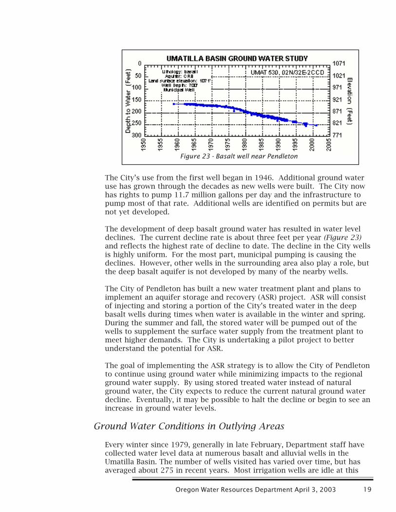
The City’s use from the first well began in 1946. Additional ground wateruse has grown through the decades as new wells were built. The City nowhas rights to pump 11.7 million gallons per day and the infrastructure topump most of that rate. Additional wells are identified on permits but arenot yet developed.
The development of deep basalt ground water has resulted in water leveldeclines. The current decline rate is about three feet per year (Figure 23)and reflects the highest rate of decline to date. The decline in the City wellsis highly uniform. For the most part, municipal pumping is causing thedeclines. However, other wells in the surrounding area also play a role, butthe deep basalt aquifer is not developed by many of the nearby wells.
The City of Pendleton has built a new water treatment plant and plans toimplement an aquifer storage and recovery (ASR) project. ASR will consistof injecting and storing a portion of the City’s treated water in the deepbasalt wells during times when water is available in the winter and spring.During the summer and fall, the stored water will be pumped out of thewells to supplement the surface water supply from the treatment plant tomeet higher demands. The City is undertaking a pilot project to betterunderstand the potential for ASR.
The goal of implementing the ASR strategy is to allow the City of Pendletonto continue using ground water while minimizing impacts to the regionalground water supply. By using stored treated water instead of naturalground water, the City expects to reduce the current natural ground waterdecline. Eventually, it may be possible to halt the decline or begin to see anincrease in ground water levels.
Ground Water Conditions in Outlying Areas
Every winter since 1979, generally in late February, Department staff havecollected water level data at numerous basalt and alluvial wells in theUmatilla Basin. The number of wells visited has varied over time, but hasaveraged about 275 in recent years. Most irrigation wells are idle at this
Figure 23 - Basalt well near Pendleton
Ground Water Supplies in the Umatilla Basin20
time and static water levels are generally at their annual high. All butapproximately 45 of the wells measured are in one of the ground watermanagement areas discussed previously in this document.
The wells located outside of the management areas include irrigation,domestic, municipal and unused wells scattered throughout the basin.Concentrations of such wells are in and around the cities northeast ofPendleton, the Pilot Rock area, and a broad area to the southwest whichincludes Ione, Lexington and Heppner. Some of these wells have long-termrecords while others have been added in more recent years in response tonew permit issuance or concerns by staff or local water users regardingpotential well interference or water level declines.
The Department received several complaints from the cities of Adams,Athena and Helix during the late 1980s. In general, the city wells were nolonger able to produce the permitted or customary quantities of water,especially in mid to late summer when demand is highest. Upon investiga-tion, the Department determined that the problems likely resulted frommultiple causes, including well or pump problems, water level declines andpumping interference from other wells.
There are approximately 40 permitted wells in the vicinity of the cities of
Adams, Athena, Weston and Helix, most of which are used for irrigation.Several of these wells pump water in sufficient quantities, and are locatedclose enough to municipal wells, such that measurable pumping interfer-ence is likely. The magnitude of the interference was estimated and deter-mined not to be substantial. Therefore, no regulation of nearby junior waterusers was necessary.
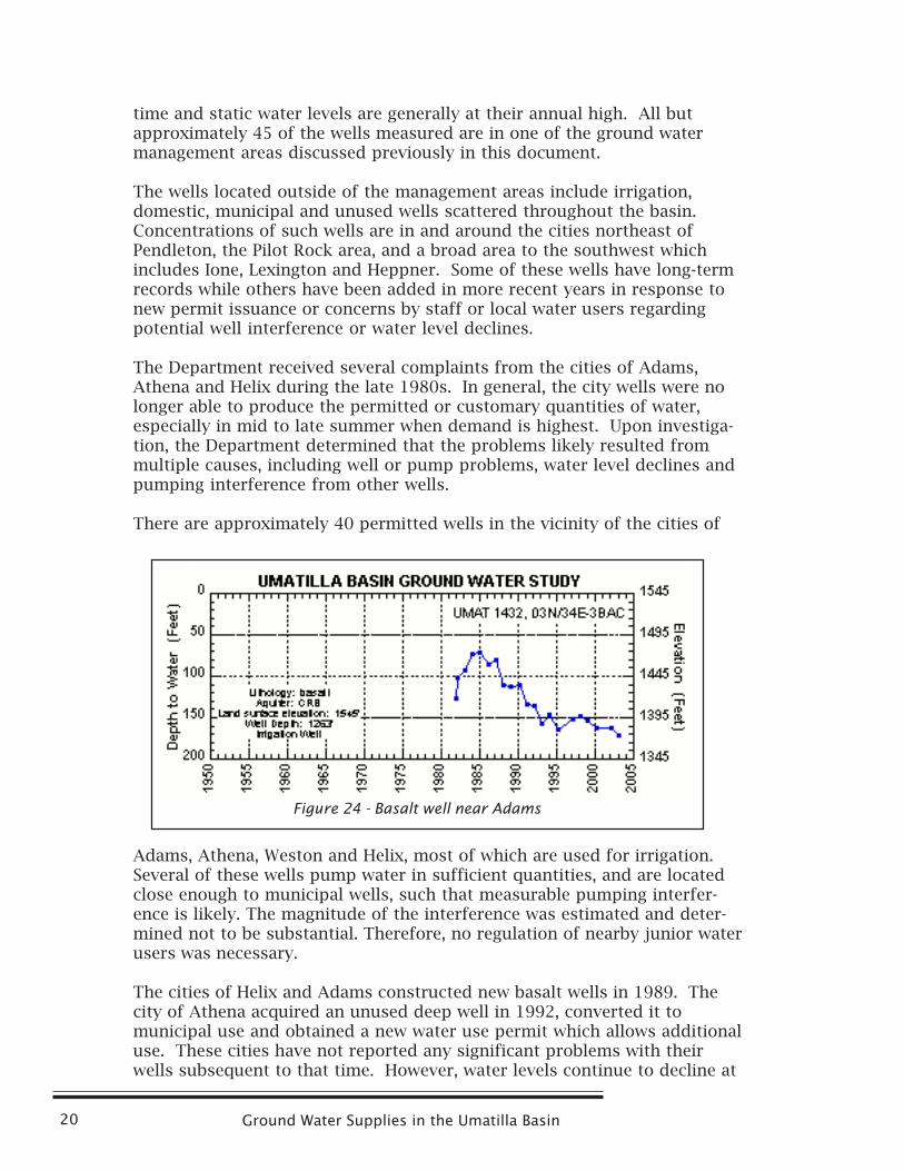
The cities of Helix and Adams constructed new basalt wells in 1989. Thecity of Athena acquired an unused deep well in 1992, converted it tomunicipal use and obtained a new water use permit which allows additionaluse. These cities have not reported any significant problems with theirwells subsequent to that time. However, water levels continue to decline at
Figure 24 - Basalt well near Adams

Oregon Water Resources Department April 3, 2003 21
many wells in this area. Figure 24 is a hydrograph for an irrigation well nearthe city of Adams. Winter static water levels at this well have declinedabout 100 feet since 1985.
In the remainder of the outlying areas of the basin, with the exception of anarea from Pilot Rock north to McKay Reservoir, development of the groundwater resource is much less concentrated than in the above cited area. Thefollowing hydrographs (Figures 25 and 26) illustrate water level trends forselected wells in these outlying areas of the Umatilla Basin. In general, waterlevels in these areas exhibit a range from relatively stable to moderatelydeclining. Water levels in more remote areas are likely responding to long-term climatic trends, while those in other areas may be influenced by bothlocal water use patterns and the climatic trends.
Existing users of basalt wells frequently express concerns regarding potentialwell interference and ground water availability whenever new uses of groundwater are proposed in their area. The Department shares these concerns, giventhe past and ongoing water level trends in the more heavily developed parts ofthe basin. Currently, there are pending ground water applications whichpropose to use significant quantities of water in areas south of the Stage Gulchand Butter Creek critical ground water areas. Water users within the critical
Figure 25 - Basalt well near Pilot Rock
Figure 26 - Basalt well south of Stage Gulch CGWA
Ground Water Supplies in the Umatilla Basin22
areas have protested these applications. Ground water staff are recommendingwater level measurement and decline conditions to be included in thesepermits, if issued. Staff currently recommend these or similar conditions fornearly all new permits for basalt wells in the basin. Water level data collectedto fulfill such permit requirements will supplement such data collected byDepartment staff, and may be used in making future management decisionsregarding the basalt ground water resource in the Umatilla Basin.
The Next Step
Oregon statutes require the Water Resources Department to manage groundwater as a renewable resource. Among other things, the Department ischarged with maintaining reasonably stable ground water levels andpreventing overdraft, substantial interference between ground water users,and substantial interference with surface water.
Economic activity within the Umatilla Basin is increasing steadily and willrequire additional supplies. Ground water will continue to be targeted as asource to accomodate this economic growth. Reliance on ground water forthose supplies may be unrealistic given today’s water management objectives.To be effective, those decisions need to be based on a thorough understandingof the conjoined ground water/surface water system. A comprehensive Basinwide ground water study is being planned to provide the necessary under-standing. In its conceptual form, the U.S. Geological Survey would beengaged as a cost share cooperator with the Water Resources Department inconducting the study. The Department is soliciting partners from the Basinto assist in the formulation of a study plan and in the financing the study.Following its completion, those same partners will be called upon to assistin developing a comprehensive ground water management plan for theBasin that makes maximum supplies of water available for economic growthwithout compromising the statutorily adopted values and goals of sustain-able ground water management.
Oregon Water Resources Department April 3, 2003 23
APPENDIX A
Basic Ground Water Concepts
Ground Water Occurrence
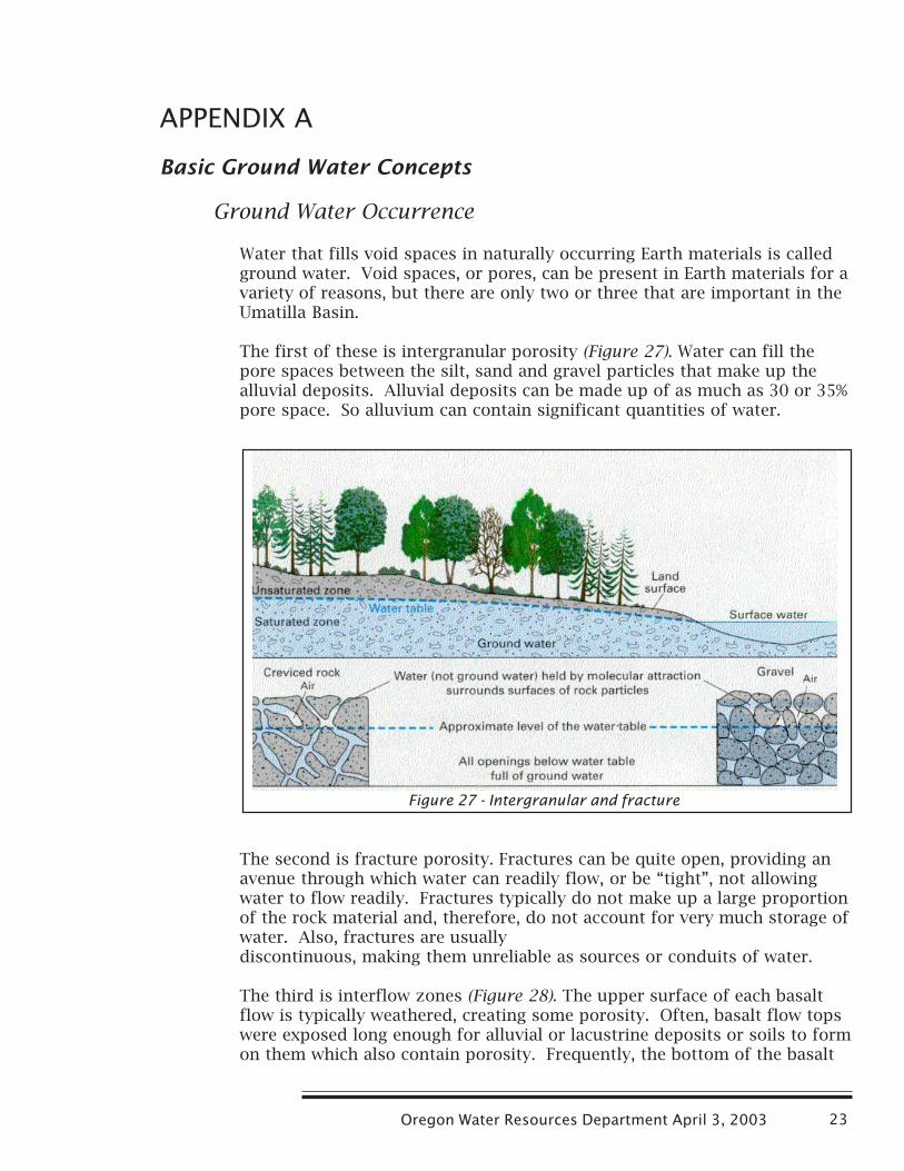
Water that fills void spaces in naturally occurring Earth materials is calledground water. Void spaces, or pores, can be present in Earth materials for avariety of reasons, but there are only two or three that are important in theUmatilla Basin.
The first of these is intergranular porosity (Figure 27). Water can fill thepore spaces between the silt, sand and gravel particles that make up thealluvial deposits. Alluvial deposits can be made up of as much as 30 or 35%pore space. So alluvium can contain significant quantities of water.
The second is fracture porosity. Fractures can be quite open, providing anavenue through which water can readily flow, or be “tight”, not allowingwater to flow readily. Fractures typically do not make up a large proportionof the rock material and, therefore, do not account for very much storage ofwater. Also, fractures are usuallydiscontinuous, making them unreliable as sources or conduits of water.
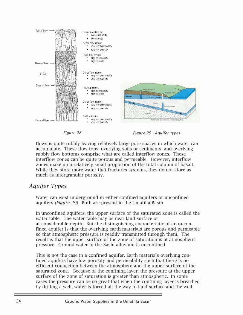
The third is interflow zones (Figure 28). The upper surface of each basaltflow is typically weathered, creating some porosity. Often, basalt flow topswere exposed long enough for alluvial or lacustrine deposits or soils to formon them which also contain porosity. Frequently, the bottom of the basalt
Figure 27 - Intergranular and fracture
Ground Water Supplies in the Umatilla Basin24
flows is quite rubbly leaving relatively large pore spaces in which water canaccumulate. These flow tops, overlying soils or sediments, and overlyingrubbly flow bottoms comprise what are called interflow zones. Theseinterflow zones can be quite porous and permeable. However, interflowzones make up a relatively small proportion of the total column of basalt.While they store more water that fractures systems, they do not store asmuch as intergranular porosity.
Aquifer Types
Water can exist underground in either confined aquifers or unconfinedaquifers (Figure 29). Both are present in the Umatilla Basin.
In unconfined aquifers, the upper surface of the saturated zone is called thewater table. The water table may be near land surface orat considerable depth. But the distinguishing characteristic of an uncon-fined aquifer is that the overlying earth materials are porous and permeableso that atmospheric pressure is readily transmitted through them. Theresult is that the upper surface of the zone of saturation is at atmosphericpressure. Ground water in the Basin alluvium is unconfined.
This is not the case in a confined aquifer. Earth materials overlying con-fined aquifers have low porosity and permeability such that there is noefficient connection between the atmosphere and the upper surface of thesaturated zone. Because of the confining layer, the pressure at the uppersurface of the zone of saturation is greater than atmospheric. In somecases the pressure can be so great that when the confining layer is breachedby drilling a well, water is forced all the way to land surface and the well
Figure 29 - Aquifer typesFigure 28
Oregon Water Resources Department April 3, 2003 25
flows. Ground water in theBasin basalts is generally con-fined.
Ground Water Flow Systems
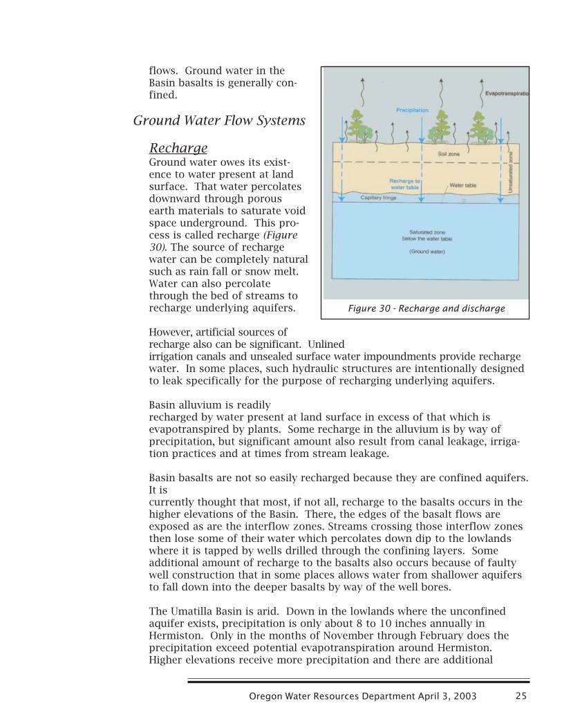
RechargeGround water owes its exist-ence to water present at landsurface. That water percolatesdownward through porousearth materials to saturate voidspace underground. This pro-cess is called recharge (Figure30). The source of rechargewater can be completely naturalsuch as rain fall or snow melt.Water can also percolatethrough the bed of streams torecharge underlying aquifers.
However, artificial sources ofrecharge also can be significant. Unlinedirrigation canals and unsealed surface water impoundments provide rechargewater. In some places, such hydraulic structures are intentionally designedto leak specifically for the purpose of recharging underlying aquifers.
Basin alluvium is readilyrecharged by water present at land surface in excess of that which isevapotranspired by plants. Some recharge in the alluvium is by way ofprecipitation, but significant amount also result from canal leakage, irriga-tion practices and at times from stream leakage.
Basin basalts are not so easily recharged because they are confined aquifers.It iscurrently thought that most, if not all, recharge to the basalts occurs in thehigher elevations of the Basin. There, the edges of the basalt flows areexposed as are the interflow zones. Streams crossing those interflow zonesthen lose some of their water which percolates down dip to the lowlandswhere it is tapped by wells drilled through the confining layers. Someadditional amount of recharge to the basalts also occurs because of faultywell construction that in some places allows water from shallower aquifersto fall down into the deeper basalts by way of the well bores.
The Umatilla Basin is arid. Down in the lowlands where the unconfinedaquifer exists, precipitation is only about 8 to 10 inches annually inHermiston. Only in the months of November through February does theprecipitation exceed potential evapotranspiration around Hermiston.Higher elevations receive more precipitation and there are additional
Figure 30 - Recharge and discharge
Ground Water Supplies in the Umatilla Basin26
months where precipitation exceeds potential evapotranspiration. It isdifficult to maintain the resource if only this natural recharge is availableand if the resource is heavily used.
The basalts recharge in an area where precipitation is somewhat greater.However, the recharge mechanism is very inefficient and it takes a longtime (probably thousands of years) for the recharged water to flow down towhere it is being withdrawn and used.
DischargeIf ground water recharges naturally, it must also discharge. If it did not, waterwould accumulate until it everywhere reached land surface. Ground waterslowly percolates through the aquifers and out into streams, lakes or wetlands.In some cases it does not quite reach land surface, but approaches only intothe root zone of plants that then evapotranspire the water as fast as itarrives. These are natural discharge processes that are ongoing largelyunseen. It is this natural discharge that maintains stream flow when thewinter snows have melted of the mountains.
Ground water can, of course, also be subject to artificial discharge pro-cesses. The most common of these is the pumping of water from wells.
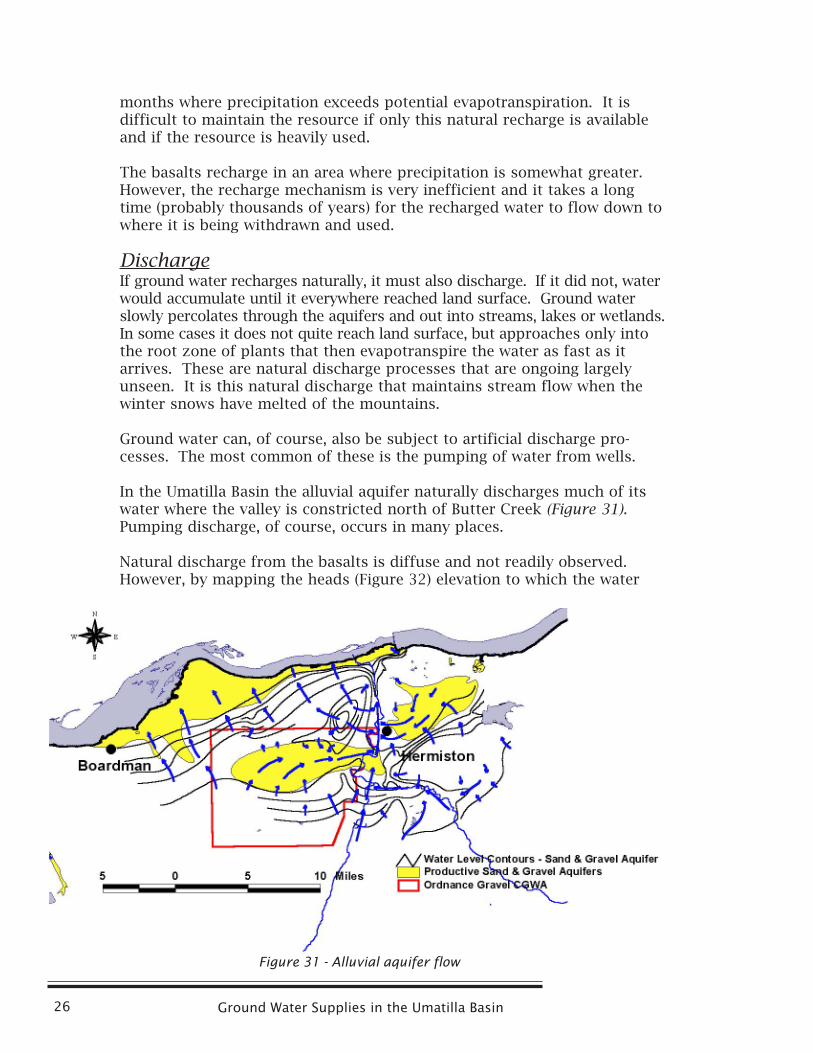
In the Umatilla Basin the alluvial aquifer naturally discharges much of itswater where the valley is constricted north of Butter Creek (Figure 31).Pumping discharge, of course, occurs in many places.
Natural discharge from the basalts is diffuse and not readily observed.However, by mapping the heads (Figure 32) elevation to which the water
Figure 31 - Alluvial aquifer flow
Oregon Water Resources Department April 3, 2003 27
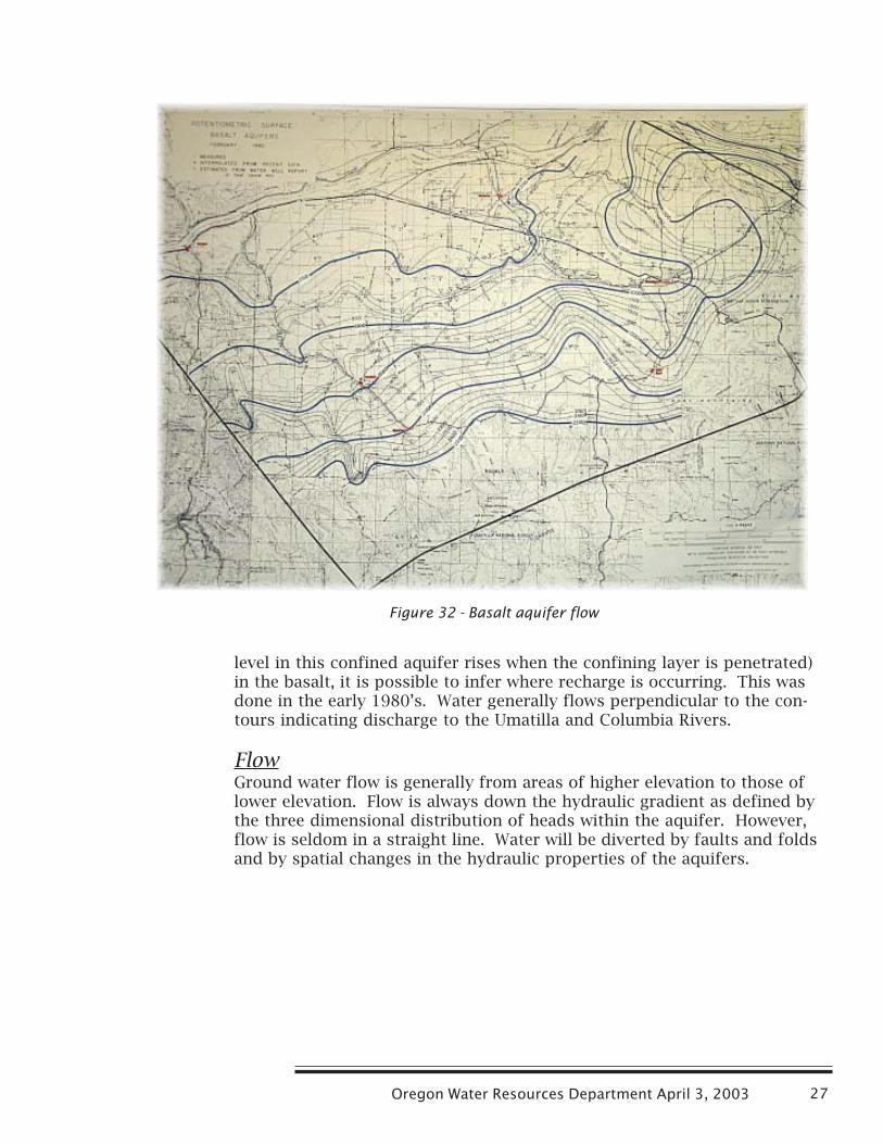
Figure 32 - Basalt aquifer flow
level in this confined aquifer rises when the confining layer is penetrated)in the basalt, it is possible to infer where recharge is occurring. This wasdone in the early 1980’s. Water generally flows perpendicular to the con-tours indicating discharge to the Umatilla and Columbia Rivers.
FlowGround water flow is generally from areas of higher elevation to those oflower elevation. Flow is always down the hydraulic gradient as defined bythe three dimensional distribution of heads within the aquifer. However,flow is seldom in a straight line. Water will be diverted by faults and foldsand by spatial changes in the hydraulic properties of the aquifers.

Ground Water Supplies in the Umatilla Basin28

Oregon Water Resources Department April 3, 2003 29
APPENDIX B
Geology of the Umatilla Basin
The Umatilla Basin is comprised of two major geologic features – theDeschutes- Umatilla Plateau and the Blue Mountains. The Deschutes-Umatilla Plateau is a broad upland plain formed by flow upon flow of basalt.The flows dip gently northward from the Blue Mountains to the ColumbiaRiver. Events that gave rise to these geologic features are described belowand a simplified geologic map of the basin is provided as Figure 33 .
Beginning about 16 million years ago and continuing over a six million yearperiod, enormous volcanic eruptions poured out basaltic lava flows fromfissures in the Earth’s crust in eastern Oregon and Washington and in Idaho.These lava flows spread out over vast areas, some flowing as far west as thePacific Ocean. The rocks formed by these eruptions are collectively referredto as the Columbia River Basalt Group, or less formerly as the ColumbiaRiver Basalts.
Over time, scores of eruptions occurred resulting in basalt layers stackedone on top of another. The eruptions occurred sporadically over time buton average 50,000 to 100,000 years elapsed between eruptions. In all, theseeruptions built up a sequence of basalt lava flows totaling over 10,000 feetin thickness in some places. These basalt flows form the dominant rockunits in the Umatilla Basin.
Figure 33 - Simple geology of Umatilla Basin
Ground Water Supplies in the Umatilla Basin30
Coincident with this volcanic activity, regional uplifting formed the BlueMountains along the south and east borders of the basin. This upliftingfolded and faulted the basalts. Large arch-shaped folds (anticlines) form theuplands. Broad U-shaped folds (synclines) form deposition basins betweenthe upland areas.
Throughout much of the Umatilla Basin, the Columbia River Basalt has beenoverlain by sedimentary deposits. Glacially-derived silts were deposited bywind on top of the basalt-dominated landscape. These wind blown siltshave been stripped away in some places and replaced by riverbed and flooddeposits, or alluvial deposits. Consisting of sands, gravels, and boulders,these deposits occur in the stream valleys and are extensive in the lowerpart of the basin.