Embed Size (px)
Citation preview

Overview on Agricultural Landscape Indicators Across OECD Countries
Dirk M. Wascher Alterra – Green World Research
P.O.Box 47, NL- 6700 AA Wageningen Tel.: 31/317.477932; Fax: 31/317.424988 E-mail: [email protected]
Abstract With the development of both a conceptual framework and the identification of practical indicator for assessing agricultural impacts on landscapes, the OECD has initiated an operational approach for measuring changes in the structure, management and values of landscapes with clear orientation towards political and economic targets. From this perspective, landscape functions and values are not longer considered to be by-products of coincidental bio-physical conditions and management regimes, but are interpreted as conscious societal demands towards the supplier or producer – namely the local farmer. The paper intends to use the existing experiences of OECD countries for identifying the main directions in landscape indicator research and application with regard to the overall objectives, namely a consistent and operational indicator assessment that allows comparing the impact of agriculture on the landscapes throughout all OECD countries. In order to provide the reader with some points of references, the paper starts off by reviewing the implementation targets for OECD landscape indicators on the basis of recognised landscape definitions and projects with special attention to current experiences in Landscape Character Assessments and the development of national and international landscape typologies. Drawing upon the references provided in the fist part, a comparative analysis of landscape indicator assessments deriving from selected examples from OECD countries provides the basis for final conclusions and recommendations. Keywords: landscape indicators, monitoring, management, agriculture, agri-environment, landscape assessment Introduction: Purpose of the Overview Mainly driven by policy demands such as sustainable development (Agenda 21), multi-functional agriculture (Common Agricultural Policy/Agenda 2000), trade liberalisation (WTO), ecosystem and landscape conservation (Ramsar Convention, European Landscape Convention, UNESCO World Heritage Convention) and on environmental reporting (Wascher, 1995), the development of agri-environmental assessments and indicators is playing an increasingly important role at both the national and international level. In the field of agriculture, OECD had taken an early lead by putting forward a system of indicators that cover a wide range of agri-environmental topics, including the social, environmental and economic aspects of farming. Agricultural landscapes form one of the key policy issues that are part of the OECD agri-environmental indicator framework. This paper seeks to provide an overview on national initiatives and programmes that have been launched to assess agricultural landscapes with the help of indicators. Since landscape assessments are
NIJOS/OECD Expert Meeting on Agricultural Landscape Indicators
NIJOS rapport /2003 2
being undertaken at every possible scale and for a multitude of purposes (Environmental Impact Assessments, regional planning, policy implementation, landscape protection, agricultural management plans, environmental reporting, etc.), the choice of references and examples must focus on nation-wide assessments and selected regional research projects. The main sources of information have been the actual and previous contributions to the OECD agri-environmental indicator process as well as some of those national and international initiatives that appear to provide helpful insights even though they are directed towards policy targets outside of OECD. An overview on current national initiatives and experiences in the application of landscape indicators among OECD countries cannot and shall not be exhaustive. The main goal must be to highlight the commonalties, differences and peculiarities with regard to the overall goal, namely to assess the environmental impact of agriculture on landscapes. The objective is hence not to undertake a case by case examination for each country or each approach – let alone a ranking or selection of preferable approaches – but to use the examples when exploring possible avenues for future indicator assessments on the basis of the overall scientific context as well as the specific policy angle of the OECD approach. Despite the obvious limitations that are set by the scope of an introductionary paper, the intention is to use the existing experiences of OECD countries for identifying the main directions in landscape indicator research and application with regard to the overall objectives, namely a consistent and operational indicator assessment that allows to compare the impact of agriculture on the landscapes throughout all OECD countries. Rather than providing as much as possible information on different national approaches (this is much better done in the individual papers), the objective is to identify those key issues that are likely to form the future agenda for the landscape indicator development in most OECD countries and that can help OECD to guide and facilitate this process. In order to reach this goal, this overview paper is structured along the following four main blocks: Review of implementation targets for OECD landscape indicators on the basis of recognised
landscape definitions and assessment projects; Comparative analysis of landscape indicator assessments on the basis on selected examples from
OECD countries; Conclusions and recommendations.
While national experiences in OECD countries are playing a central role in this overview, the paper will make frequent reference to results deriving from a few relevant international projects that have contributed to the development of common standards. The author draws mainly upon studies undertaken in the framework former or current European Union projects with the participation of the expert network Landscape Europe. 1. Implementation Targets for OECD Landscape Indicators 1.1 The agricultural landscape – a socio-economic ecosystem At the beginning of last century, scientists such as zoologists, biologists, botanists, or hydrologists felt increasingly challenged to overcome their disciplinary boundaries by identifying and establishing inter-relations in a more integrated fashion. The two main outflows of these efforts were the concepts of “ecosystem” and “landscape”. Since both terms are frequently being used for very similar environmental phenomena – namely for larger spatial area units of land with characteristic biophysical structures and functions – a sound differentiation between the two concepts has become increasingly relevant for the development of targeted policies or other societal responses.
NIJOS/OECD Expert Meeting on Agricultural Landscape Indicators
NIJOS rapport /2003 3
According to Tansely (1935), ‘an ecosystem can be defined as a spatially explicit unit of the Earth that includes all of the organisms along with all components of the abiotic (non-living) environment with its boundaries’. By itself the term ‘ecosystem’ (short form of ‘ecological system’) does not connote any specific dimensions (IGBP, 1986), posing technical difficulties to the identification of clearly recognisable boundaries. In comparison to the ‘ecosystem’ approach, the landscape concept does not derive from a purely ecological tradition, but is rooted in a wide range of both social and natural disciplines – including geographic, ecological and artistic approaches –dating back to the early 1800s. Other than in the English tradition where the term “landscape” is somewhat restricted to “scenery”, the Dutch and German meaning of the equivalent terms ‘landschap’ or ‘Landschaft’ is of wider scope, namely in the sense of the "total character of a region" (Von Humboldt, 1808). Humboldt’s definition of landscape became a guiding principle for many landscape scientist across Europe and America when analysing landscapes in an integrated fashion – taking into account social, aesthetic, economic and environmental aspects. Zonneveld (2000) stressed the differences with the English term ‘landscape ecology’ when defining "Landschaftsökologie" as "the study of the relational system at the surface of the earth that can be recognised by its form and shape". The aspect of recognition is even more directly addressed by Steiner (1991): “Landscape is all the natural features such as fields, hills, forests, and water that distinguish one part of the surface of the earth from another part. Usually, a landscape is that portion of land or territory which the eye can comprehend in a single view, including all its natural characteristics”. The visual aspects of landscapes have been taken up by OECD which defines agricultural landscapes as “the visible outcomes from the interaction between agriculture, natural resources and the environment, and encompass amenity, cultural, and other societal values.” (OECD 2001). More than other landscape definitions that have been developed during the last decades, the OECD approach is meant to provide the basis for an operational framework for landscape assessment at the international level with clear orientation towards political and economic targets. From this perspective, landscape functions and values are not longer considered to be by-products of coincidental bio-physical conditions and management regimes, but are interpreted as conscious societal demands towards the supplier or producer – namely the local farmer. The most adequate short formula that summarises such a point of view is to define agricultural landscapes as ‘socio-economic ecosystems’. 1.2 An operational approach: Landscape Character Assessment As complex socio-economic ecosystems with regionally distinct configurations of geo-morphology, soil, water, vegetation and human land use, landscapes are the products of both human activities and natural processes that are following the vectors of driving forces such as policies, demography, economy or climate change. The degree to which human activities and natural processes are interacting or have been interacting in the past determines the character of a landscape. Landscape character can hence be considered as the land’s principle physiognomic profile in terms of climate, geo-morphology, topography, soils and the associated natural vegetation and land use (see Figure 1). Though the character of a landscape can be the object of human perception and evaluation, character is not to be confused with the quality of a landscape, which is mainly dependent on the functions that have been assigned to it, e.g. aesthetic, recreational, economic and ecological.

NIJOS/OECD Expert Meeting on Agricultural Landscape Indicators
NIJOS rapport /2003 4
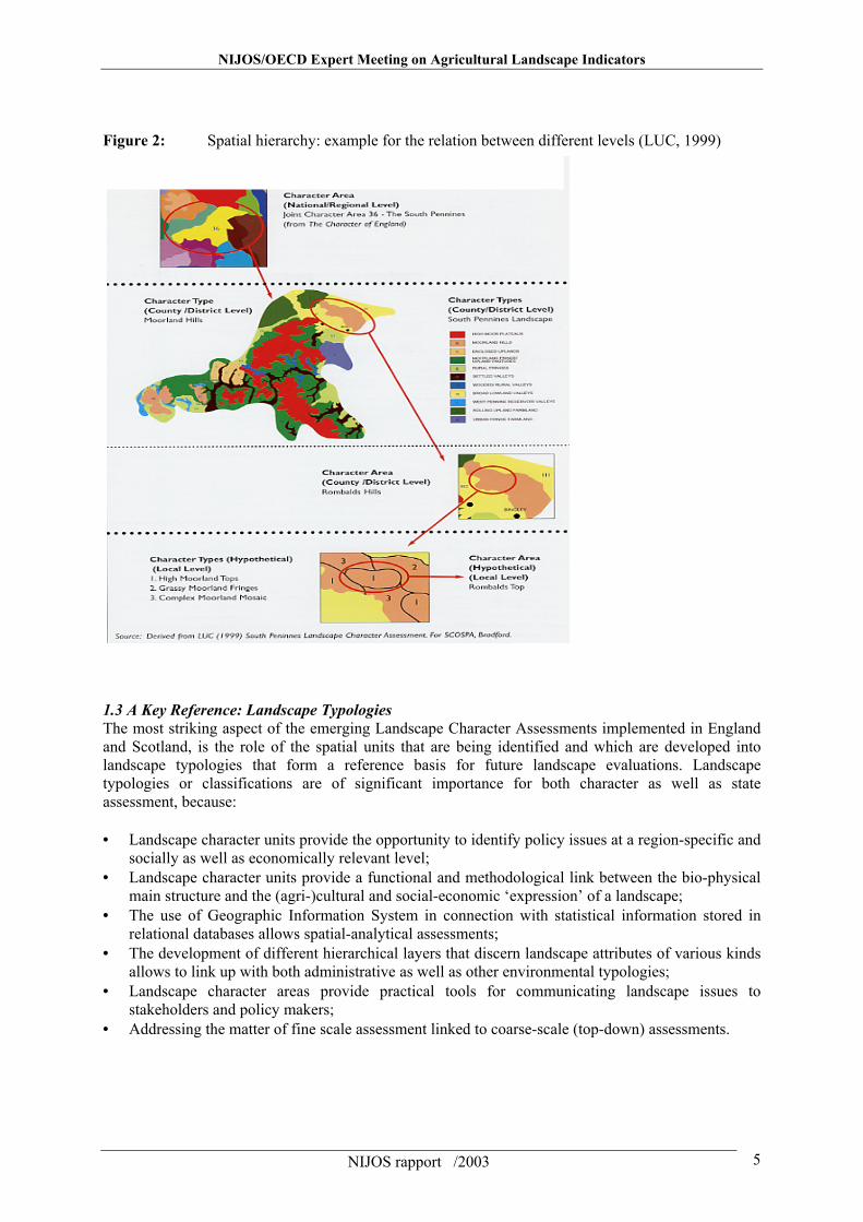
Figure 1: Landscape character consisting of three main layers: bio-physical main structure, vegetation & land use patterns and cultural elements (Wascher after Krause & Klöppel, 1996) Obtaining a record of the landscape character should hence be considered as a way of identifying the basic structures of their biophysical components and cultivation patterns. Understanding the structural character of a landscape is not only a pre-requisite for measuring the state or quality of a landscape, but also for identifying the most relevant pressures that affect this state. Mainly in the United Kingdom, but also in Sweden, the Netherlands and Austria, different forms of Landscape Character Assessment are being implemented; some of them date back to the early 1970ties. In England, for example, the Countryside Agency developed this technique as a tool to separate the classification and description of landscape character (Steiner’s “what makes one area different from another”) from landscape evaluation. The main objectives for such assessments are as follows: • Identify what environmental and cultural features are present in a locality; • Monitor changes in the environment; • Understand a location’s sensitivity to development and change; • Inform the conditions for any development and change. Directly in line with Humboldt who explained landscapes as “dynamic systems of spatial structures” or with Rosenkranz (1850) who interpreted landscapes as “unit[s] of stepwise-integrated local systems”, modern landscape character assessment introduces a hierarchy of spatial-structural levels in which higher units are composed of different sub-units (see Figure 2).
Bio-physical main structure: Geology / soils Topography Hydrology
Vegetation & land use patterns: Forest & riparian vegetation Agricultural lands Linear and punctual elements
Cultural elements: Settlements & monuments infrastructure other man-built objects
NIJOS/OECD Expert Meeting on Agricultural Landscape Indicators
NIJOS rapport /2003 5
Figure 2: Spatial hierarchy: example for the relation between different levels (LUC, 1999) 1.3 A Key Reference: Landscape Typologies The most striking aspect of the emerging Landscape Character Assessments implemented in England and Scotland, is the role of the spatial units that are being identified and which are developed into landscape typologies that form a reference basis for future landscape evaluations. Landscape typologies or classifications are of significant importance for both character as well as state assessment, because: • Landscape character units provide the opportunity to identify policy issues at a region-specific and
socially as well as economically relevant level; • Landscape character units provide a functional and methodological link between the bio-physical
main structure and the (agri-)cultural and social-economic ‘expression’ of a landscape; • The use of Geographic Information System in connection with statistical information stored in
relational databases allows spatial-analytical assessments; • The development of different hierarchical layers that discern landscape attributes of various kinds
allows to link up with both administrative as well as other environmental typologies; • Landscape character areas provide practical tools for communicating landscape issues to
stakeholders and policy makers; • Addressing the matter of fine scale assessment linked to coarse-scale (top-down) assessments.
NIJOS/OECD Expert Meeting on Agricultural Landscape Indicators
NIJOS rapport /2003 6
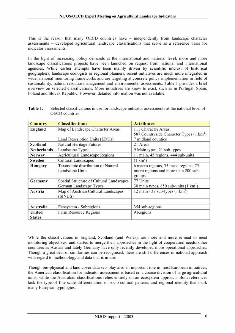
This is the reason that many OECD countries have – independently from landscape character assessments – developed agricultural landscape classifications that serve as a reference basis for indicator assessments. In the light of increasing policy demands at the international and national level, more and more landscape classifications projects have been launched on request from national and international agencies. While earlier attempts have been mainly driven by scientific interest of historical geographers, landscape ecologists or regional planners, recent initiatives are much more integrated in wider national monitoring frameworks and are targeting at concrete policy implementation in field of sustainability, natural resource management and environmental assessments. Table 1 provides a brief overview on selected classifications. More initiatives are know to exist, such as in Portugal, Spain, Poland and Slovak Republic. However, detailed information was not available. Table 1: Selected classifications in use for landscape indicator assessments at the national level of OECD countries Country Classifications Attributes England Map of Landscape Character Areas
Land Description Units (LDUs)
111 Character Areas, 587 Countryside Character Types (1 km2) 7 midland counties
Scotland Natural Heritage Futures 21 Areas Netherlands Landscape Types 9 Main types, 21 sub-types Norway Agricultural Landscape Regions 11 main, 45 regions, 444 sub-units Sweden Cultural Landscapes (1 km2) Hungary Taxonomic distribution of Natural
Landscape Units 6 macro regions, 35 meso regions, 75 micro regions and more than 200 sub-groups
Germany Spatial Structure of Cultural Landscapes German Landscape Types
77 Units 30 main types, 850 sub-units (1 km2)
Austria Map of Austrian Cultural Landscapes (SINUS)
12 main / 37 sub-types (1 km2)
Australia Ecosystem - Subregions 354 sub-regions United States
Farm Resource Regions 9 Regions
While the classifications in England, Scotland (and Wales), are more and more refined to meet monitoring objectives, and started to merge their approaches in the light of cooperation needs, other countries as Austria and lately Germany have only recently developed more operational approaches. Though a great deal of similarities can be recognised, there are still differences in national approach with regard to methodology and data that is in use. Though bio-physical and land cover data sets play also an important role in most European initiatives, the American classification for indicator assessment is based on a coarse division of large agricultural units, while the Australian classifications relies entirely on an ecosystem approach. Both references lack the type of fine-scale differentiation of socio-cultural patterns and regional identity that mark many European typologies.
NIJOS/OECD Expert Meeting on Agricultural Landscape Indicators
NIJOS rapport /2003 7
Austria The Austrian SINUS Cultural Landscape project stands central to these efforts. It is based on land cover classification (Landsat) and identifies “cultural landscapes” (16.000 polygons). In its latest version it differentiates 12 main and 37 sub-types of Cultural Landscapes, using their farming names for identification. At the local level, a scale of 1:10.000 is available. Inspired by the British Countryside Survey, a series of 200 ground samples of 1 km² have been taken, examining biodiversity issues (e.g. character species) as well as the degree of urbanisation (fragmentation, distance from roads, etc.). The methodology had been developed as part of the pre-project “Cultural Landscape Typology of Austria on the basis of 16 test sites. England As part of the “Living Landscape” initiative, a framework of Land Description Units (LDUs) is being developed for a study area covering 7 midland counties of England. The LDUs are derived through a process of overlay mapping, which draws out the relationship between the natural and cultural dimensions of the landscape. Using contour and geological overlays the study area is divided initially into broad physiographic units (e.g. river valleys, glacial plateau, etc.). By overlaying soils and farm type information these units are then subdivided, where appropriate, to distinguish the broad pattern of vegetation and land use. This in turn is used as a framework for understanding and mapping the historic pattern of enclosure and settlement (Countryside Commission, 1993; Countryside Agency 2000). Germany The Federal Agency for Nature Conservation (BfN) is just in a final phase of completing a project of mapping landscapes types on classifying, mapping and evaluating the landscape types of Germany. Using the digital boundaries and data of CORINE Land cover in combination with the natural area system and regional planning documents, the project resulted in the identification of 6 main landscape types (coastal, forests, highly structured agricultural lands, poorly structured agricultural lands, mining restoration areas), that have been sub-divided into 30 types (plus two zonal types, namely hedgerow and riparian landscapes). Below this level, a total of 850 units have been identified from which about 60 urban areas have been cut out. Minimum size of each unit was 1 km². The evaluation which is still continuing depends on land use intensity (hemerobie) and rareness, running two separate a assessment procedures (types + objects). European Landscape Character Assessment Initiative (ELCAI) The goal of this European Union funded Research Project is to review the state-of-the-art landscape character assessments for 17 European countries as well as international approaches by Joint Research Centre, Eurostat and the EEA/ETC TE with special focus on the development of a common European landscape typology, map and core set of indicators;
- to review existing landscape policies at the national and international level; - to initiate inter-agency cooperation in support of sectoral integration and stakeholder involvement
when developing and applying new assessment tools; - to organise an international workshop for cross-disciplinary exchange and stakeholder input; - to disseminate the key products (report, map and indicators) by means of a scientific report, a
policy brochure and an internet database, providing guidance for future landscape assessments. 2. Overview of Landscape Indicators in OECD Countries 2.1 Brief review of the OECD approach Table 2 illustrates OECD’s indicator framework consisting of four main themes on socio-economy and policy, farm management, use of input and resources and environmental impacts. The field of “landscape” constitutes one out of seven environmental impact areas for which indicators have been
NIJOS/OECD Expert Meeting on Agricultural Landscape Indicators
NIJOS rapport /2003 8
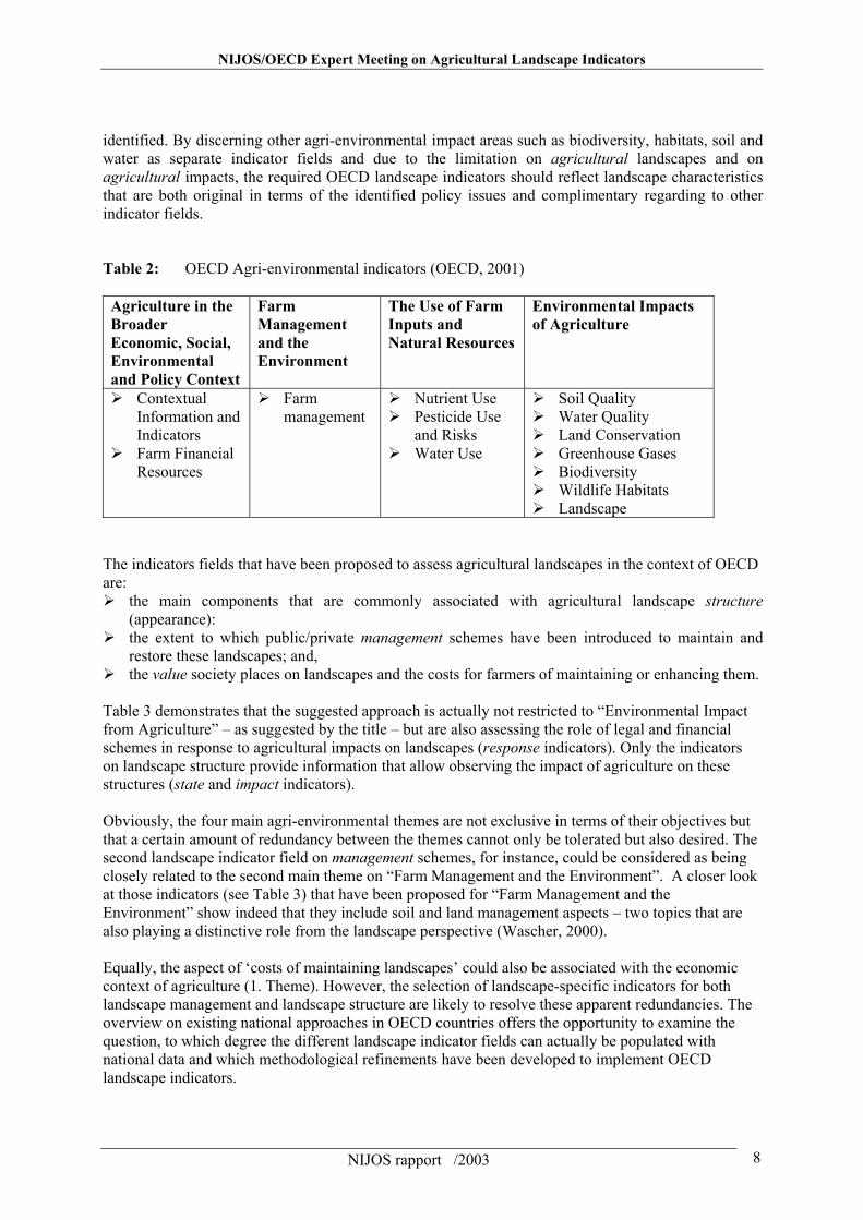
identified. By discerning other agri-environmental impact areas such as biodiversity, habitats, soil and water as separate indicator fields and due to the limitation on agricultural landscapes and on agricultural impacts, the required OECD landscape indicators should reflect landscape characteristics that are both original in terms of the identified policy issues and complimentary regarding to other indicator fields. Table 2: OECD Agri-environmental indicators (OECD, 2001) Agriculture in the Broader Economic, Social, Environmental and Policy Context
Farm Management and the Environment
The Use of Farm Inputs and Natural Resources
Environmental Impacts of Agriculture
Contextual Information and Indicators Farm Financial
Resources
Farm management
Nutrient Use Pesticide Use
and Risks Water Use
Soil Quality Water Quality Land Conservation Greenhouse Gases Biodiversity Wildlife Habitats Landscape
The indicators fields that have been proposed to assess agricultural landscapes in the context of OECD are: the main components that are commonly associated with agricultural landscape structure
(appearance): the extent to which public/private management schemes have been introduced to maintain and
restore these landscapes; and, the value society places on landscapes and the costs for farmers of maintaining or enhancing them.
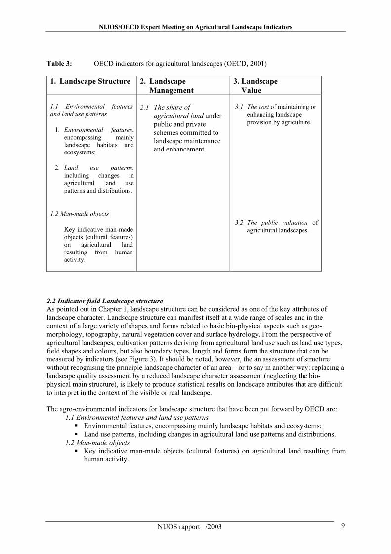
Table 3 demonstrates that the suggested approach is actually not restricted to “Environmental Impact from Agriculture” – as suggested by the title – but are also assessing the role of legal and financial schemes in response to agricultural impacts on landscapes (response indicators). Only the indicators on landscape structure provide information that allow observing the impact of agriculture on these structures (state and impact indicators). Obviously, the four main agri-environmental themes are not exclusive in terms of their objectives but that a certain amount of redundancy between the themes cannot only be tolerated but also desired. The second landscape indicator field on management schemes, for instance, could be considered as being closely related to the second main theme on “Farm Management and the Environment”. A closer look at those indicators (see Table 3) that have been proposed for “Farm Management and the Environment” show indeed that they include soil and land management aspects – two topics that are also playing a distinctive role from the landscape perspective (Wascher, 2000). Equally, the aspect of ‘costs of maintaining landscapes’ could also be associated with the economic context of agriculture (1. Theme). However, the selection of landscape-specific indicators for both landscape management and landscape structure are likely to resolve these apparent redundancies. The overview on existing national approaches in OECD countries offers the opportunity to examine the question, to which degree the different landscape indicator fields can actually be populated with national data and which methodological refinements have been developed to implement OECD landscape indicators.
NIJOS/OECD Expert Meeting on Agricultural Landscape Indicators
NIJOS rapport /2003 9
Table 3: OECD indicators for agricultural landscapes (OECD, 2001) 1. Landscape Structure 2. Landscape
Management 3. Landscape Value
1.1 Environmental features and land use patterns
1. Environmental features, encompassing mainly landscape habitats and ecosystems;
2. Land use patterns, including changes in agricultural land use patterns and distributions.
1.2 Man-made objects
Key indicative man-made objects (cultural features) on agricultural land resulting from human activity.
2.1 The share of
agricultural land under public and private schemes committed to landscape maintenance and enhancement.
3.1 The cost of maintaining or
enhancing landscape provision by agriculture.
3.2 The public valuation of agricultural landscapes.
2.2 Indicator field Landscape structure As pointed out in Chapter 1, landscape structure can be considered as one of the key attributes of landscape character. Landscape structure can manifest itself at a wide range of scales and in the context of a large variety of shapes and forms related to basic bio-physical aspects such as geo-morphology, topography, natural vegetation cover and surface hydrology. From the perspective of agricultural landscapes, cultivation patterns deriving from agricultural land use such as land use types, field shapes and colours, but also boundary types, length and forms form the structure that can be measured by indicators (see Figure 3). It should be noted, however, the an assessment of structure without recognising the principle landscape character of an area – or to say in another way: replacing a landscape quality assessment by a reduced landscape character assessment (neglecting the bio-physical main structure), is likely to produce statistical results on landscape attributes that are difficult to interpret in the context of the visible or real landscape. The agro-environmental indicators for landscape structure that have been put forward by OECD are:
1.1 Environmental features and land use patterns Environmental features, encompassing mainly landscape habitats and ecosystems; Land use patterns, including changes in agricultural land use patterns and distributions.
1.2 Man-made objects Key indicative man-made objects (cultural features) on agricultural land resulting from
human activity.
NIJOS/OECD Expert Meeting on Agricultural Landscape Indicators
NIJOS rapport /2003 10
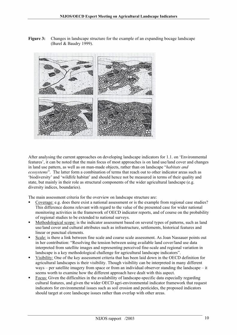
Figure 3: Changes in landscape structure for the example of an expanding bocage landscape (Burel & Baudry 1999).
After analysing the current approaches on developing landscape indicators for 1.1. on ‘Environmental features’, it can be noted that the main focus of most approaches is on land use/land cover and changes in land use pattern, as well as on man-made objects, rather than on landscape “habitats and ecosystems”. The latter form a combination of terms that reach out to other indicator areas such as ‘biodiversity’ and ‘wildlife habitat’ and should hence not be measured in terms of their quality and state, but mainly in their role as structural components of the wider agricultural landscape (e.g. diversity indices, boundaries). The main assessment criteria for the overview on landscape structure are: Coverage: e.g. does there exist a national assessment or is the example from regional case studies?
This difference deems relevant with regard to the value of the presented case for wider national monitoring activities in the framework of OECD indicator reports, and of course on the probability of regional studies to be extended to national surveys.
Methodological scope: is the indicator assessment based on several types of patterns, such as land use/land cover and cultural attributes such as infrastructure, settlements, historical features and linear or punctual elements.
Scale: is there a link between fine scale and coarse scale assessment. As Joan Nassauer points out in her contribution: “Resolving the tension between using available land cover/land use data interpreted from satellite images and representing perceived fine-scale and regional variation in landscape is a key methodological challenge for agricultural landscape indicators”.
Visibility: One of the key assessment criteria that has been laid down in the OECD definition for agricultural landscapes is their visibility. Though visibility can be interpreted in many different ways – per satellite imagery from space or from an individual observer standing the landscape – it seems worth to examine how the different approach have dealt with this aspect.
Focus: Given the difficulties in the availability of landscape-specific data especially regarding cultural features, and given the wider OECD agri-environmental indicator framework that request indicators for environmental issues such as soil erosion and pesticides, the proposed indicators should target at core landscape issues rather than overlap with other areas.
NIJOS/OECD Expert Meeting on Agricultural Landscape Indicators
NIJOS rapport /2003 11
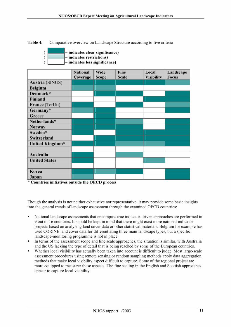
Table 4: Comparative overview on Landscape Structure according to five criteria ( = indicates clear significance) ( = indicates restrictions) ( = indicates less significance) National
Coverage Wide Scope
Fine Scale
Local Visibility
Landscape Focus
Austria (SINUS) Belgium Denmark* Finland France (TerUti) Germany* Greece Netherlands* Norway Sweden* Switzerland United Kingdom* Australia United States Korea Japan
* Countries initiatives outside the OECD process Though the analysis is not neither exhaustive nor representative, it may provide some basic insights into the general trends of landscape assessment through the examined OECD countries: National landscape assessments that encompass true indicator-driven approaches are performed in
9 out of 16 countries. It should be kept in mind that there might exist more national indicator projects based on analysing land cover data or other statistical materials. Belgium for example has used CORINE land cover data for differentiating three main landscape types, but a specific landscape-monitoring programme is not in place.
In terms of the assessment scope and fine scale approaches, the situation is similar, with Australia and the US lacking the type of detail that is being reached by some of the European countries.
Whether local visibility has actually been taken into account is difficult to judge. Most large-scale assessment procedures using remote sensing or random sampling methods apply data aggregation methods that make local visibility aspect difficult to capture. Some of the regional project are more equipped to measurer these aspects. The fine scaling in the English and Scottish approaches appear to capture local visibility.
NIJOS/OECD Expert Meeting on Agricultural Landscape Indicators
NIJOS rapport /2003 12
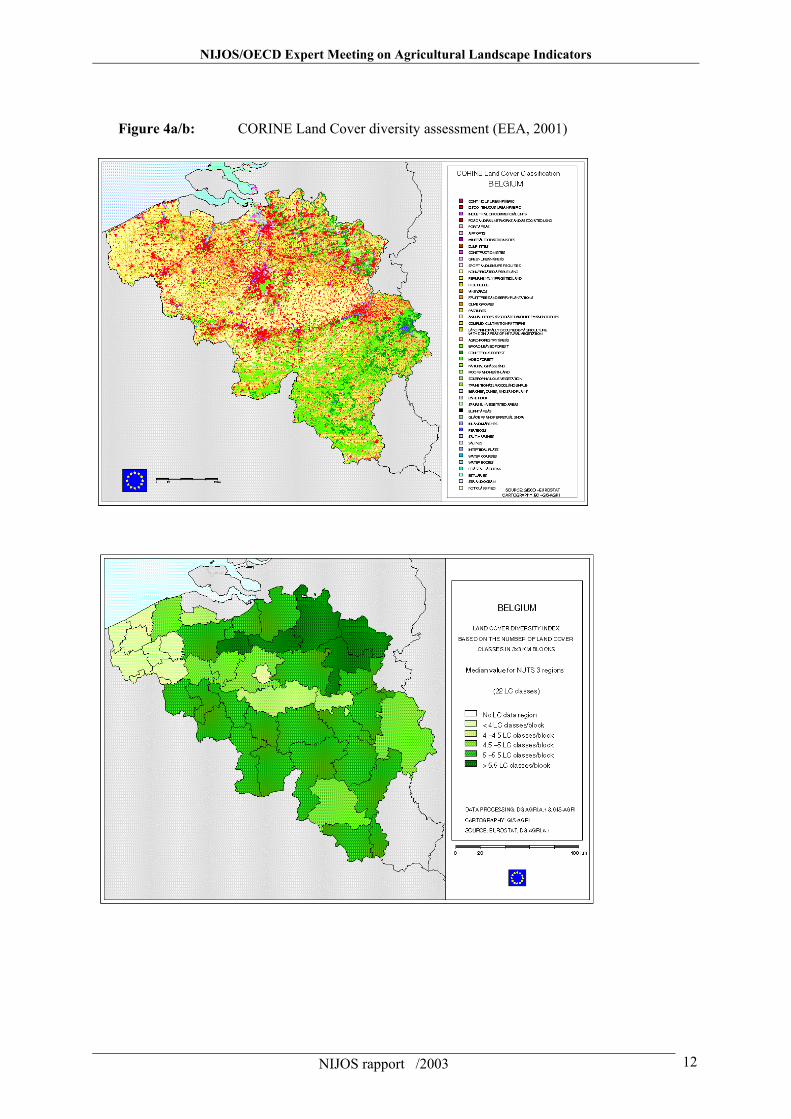
Figure 4a/b: CORINE Land Cover diversity assessment (EEA, 2001)
NIJOS/OECD Expert Meeting on Agricultural Landscape Indicators
NIJOS rapport /2003 13
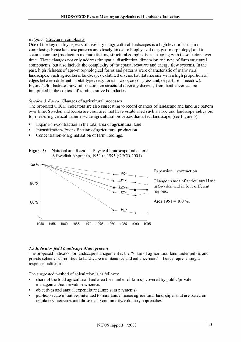
Belgium: Structural complexity One of the key quality aspects of diversity in agricultural landscapes is a high level of structural complexity. Since land use patterns are closely linked to biophysical (e.g. geo-morphology) and to socio-economic (production method) factors, structural complexity is changing with these factors over time. These changes not only address the spatial distribution, dimension and type of farm structural components, but also include the complexity of the spatial resource and energy flow systems. In the past, high richness of agro-morphological forms and patterns were characteristic of many rural landscapes. Such agricultural landscapes exhibited diverse habitat mosaics with a high proportion of edges between different habitat types (e.g. forest – crop, crop – grassland, or pasture – meadow). Figure 4a/b illustrates how information on structural diversity deriving from land cover can be interpreted in the context of administrative boundaries. Sweden & Korea: Changes of agricultural processes The proposed OECD indicators are also suggesting to record changes of landscape and land use pattern over time. Sweden and Korea are countries that have established such a structural landscape indicators for measuring critical national-wide agricultural processes that affect landscape, (see Figure 5):
• Expansion-Contraction in the total area of agricultural land. • Intensification-Extensification of agricultural production. • Concentration-Marginalisation of farm holdings. Figure 5: National and Regional Physical Landscape Indicators: A Swedish Approach, 1951 to 1995 (OECD 2001)
Expansion – contraction
Change in area of agricultural land in Sweden and in four different regions.
Area 1951 = 100 %.
2.3 Indicator field Landscape Management The proposed indicator for landscape management is the “share of agricultural land under public and private schemes committed to landscape maintenance and enhancement” – hence representing a response indicator. The suggested method of calculation is as follows: • share of the total agricultural land area (or number of farms), covered by public/private
management/conservation schemes. • objectives and annual expenditure (lump sum payments) • public/private initiatives intended to maintain/enhance agricultural landscapes that are based on
regulatory measures and those using community/voluntary approaches.
NIJOS/OECD Expert Meeting on Agricultural Landscape Indicators
NIJOS rapport /2003 14
International conservation schemes At the level of the European Union, specifically designed agri-environmental measures targeting among other at landscape enhancement and conservation have been put in place since about 10 years. A DG Agriculture Working Document (CEC, 1998) reviewed the implementation of the Council Regulation No (EEC) 2078/92 that applies to 900.000 farms and 27 million hectares, or 20% of the EU farmland. The Commission’s report recognised ‘sub-national environmental benefits from programmes’ and noted that the establishment of an ‘evaluation culture’ in programme management is successful in many cases. Furthermore it is recommended using the ‘landscape system’ approach for the implementation of measures. Regarding the overall situation of agricultural land management and landscape conservation in Europe, the European Union’s Agenda 2000 marks a new stage in the continuing reform process, which aims to bring about a farm sector closer to market realities, to consumers and to the environment. In addition, year 2000 was the start of the adoption to the first new generation rural development programmes for the period 2000-2006. One of the main outcomes was the establishment of a new Rural Development Regulation (RDR). The RDR supports rural development and agri-environment schemes designed to diversify rural economies, to encourage farmers to look to markets and diversified forms of income to reduce their dependence on subsidy, and enhance the environment. For the first time, EU funding is now available for rural development programmes everywhere in the Community, instead of being only available in designated regions, as was the case in the past. Another new feature is that agri-environmental schemes, which used to be optional, now have to be included in all programmes. These schemes are to compensate farmers for income losses they might suffer as a result of managing their farms in more environmentally- friendly ways. Future agri-environmental on landscape management in OECD countries are likely to take up these type of international policy schemes in support of environmental and landscape conservation. National landscape conservation schemes Especially in Europe, landscape conservation and also management schemes have a rather long history. Landscape conservation schemes play a significant role in many European countries and are covering larger surface areas than most other conservation schemes. Though landscape conservation is not as restrictive than area protection for the purpose of biodiversity conservation, there are principle rules of agricultural management and planning in place. The European Landscape Convention (opened for signature in October 2000) According to the Explanatory Report of the Draft European Landscape Convention (Council of Europe 2000), the general purpose of the Convention is to encourage public authorities to adopt policies and measures at local, regional, national and international levels for protecting, managing and planning landscapes throughout Europe so as to maintain and improve landscape quality and bring the public, institutions and local and regional authorities to recognise the value and importance of landscape and to take part in related public decisions. 2.4. Indicator field Landscape values The indicator field ‘landscape values’ appears to be somewhat related to the field on ‘landscape management’, as it is supposed to measure
1. The cost of maintaining or enhancing landscapes provisions by agriculture. 2. The public valuation of agricultural landscapes.
Measuring the costs of landscape provision can help policy makers determine the outlays by farmers in maintaining and/or restoring certain landscape elements. These costs may relate to cultural and
NIJOS/OECD Expert Meeting on Agricultural Landscape Indicators
NIJOS rapport /2003 15
heritage features, such as spending by farmers on the conservation of historic sites and/or buildings on farmland. However, expenditure could also involve costs incurred in hedge or stone wall maintenance that, while providing a positive externality in terms of the landscape may also generate benefits for the farmer, for example, by providing a windshield for crops and livestock. The use of Contingent Value Methods (CVM and the development of landscape scenarios, could provide useful tools assessing public appreciation of landscape values. In comparison with the previous two indicator fields, ‘landscape value’ indicators are scarce. The Australian example (see Table 5) is the only one that illustrates the great potential of semi-administrative data in measuring the societal values that have been attributed to cultural and landscape values. Even though more countries might be inclined to explore these assessment methods in the future, it will be necessary to reach a high level of harmonisation in order arrive at internationally comparable data. Table 5: Cultural value indicators for Australia (Pearson et al., 1999) Issue or element Indicator State (S)
Pressure (P) Response (R)
Knowledge of the Heritage resource
Number and distribution of identified heritage (places and objects)
Number of heritage places assessed
S/R R
Culturally appropriate directions in conservation and management of heritage places
Number of places where indigenous people are involved in heritage management decision making by” i) indigenous land ownership ii) joint management iii) recognised custodership iv) direct consultation
Number of government agencies that provide procedures and consultations to community groups
Number of trained heritage professionals
S / R S / R S / R
Cultural heritage maintenance
Number of indigenous communities/organisations establishing i) ‘keeping places’ ii) cultural centres iii) site / place data bases iv) heritage tours, trails, walks
S / R
NIJOS/OECD Expert Meeting on Agricultural Landscape Indicators
NIJOS rapport /2003 16
3. Conclusions and Recommendations 3.1 Conclusions The multi-sectoral approach taken OECD for developing agri-environmental indicators has proven to be the adequate response towards a complex interface between the agriculture, the environment and emerging policy requirements. The process of developing a conceptual framework for agri-environmental indicators has demonstrated the need to bridge the gap between existing models (such as pressure/driving force – state – response) and the functional links that characterise actual agri-environmental processes. The objectives laid down in recent policy documents addressing issues such as rural development, cultural landscapes and regional identity, have made clear that future agri-environmental assessment can no longer be based on strictly mono-analytical approaches but must apply methods of integration. Throughout all these issues socio-economic considerations play a vital role when defining environmental objectives. The following conclusion are meant to cast more light on the future choices and implementation targets for landscape indicators by addressing some of the most relevant findings of this overview:
Many OECD countries haven taken a rather pro-active approach towards the implementation of indicator-based landscape assessments. Over the last years, a series of countries have developed more refined methodologies in terms of spatial resolution and policy orientation, resulting in impressive monitoring and reporting products at the national level.
Landscape structure is the indicator field that is most commonly in use and where an
increasing number of sophisticated techniques (e.g. Geographic Information Management) are being developed. Most of the large-scale (national) assessments on landscape structure focus on land cover and land use analysis – frequently based on remote sensing data, random sampling techniques involving aerial photography or agricultural statistics. Fine-scale structural elements such as linear and point forms, cultural patterns and materials relevant for the local visibility and a landscape perception that is not restricted to satellite perspectives, are limited to regional and local case studies
The analysis of landscape structures is most consequently performed in countries that are
undertaking ‘Landscape Character Assessments” and where national landscape typologies as references for indicator assessments and interpretation are being developed. Landscape Character Assessments based on landscape typologies take are more region-specific approach than pure structure-analytical techniques.
The indicator fields on landscape management and value are clearly less strongly developed.
This comes, as a surprise since national statistics on response mechanisms such as landscape conservation, management and education is very likely to be available in relatively great detail for most countries. It can be assumed that a target approach towards the population of these indicator fields with existing data could provide the most substantial advances in terms of cross-national comparisons. It only requires a systematic approach when identifying the main types of management schemes and the accompanying financial structure.
National activities are increasing supported by international projects such as the European
Landscape Character Assessment Initiative (ELCAI, co-ordinated by Landscape Europe), the Environmental Risk Assessment for European Agriculture (ENRISK, co-ordinated by the European Centre for Nature Conservation), the Land Use and Land Cover Area Sampling
NIJOS/OECD Expert Meeting on Agricultural Landscape Indicators
NIJOS rapport /2003 17
(LUCAS, co-ordinated by the European Statistical Office) and the Millennium Assessment that includes a section on cultural landscapes.
3.2 Recommendations In order to foster future support for sustainable agricultural landscapes, it is recommended that OECD: Provides considerable support and takes action to further the development and targeting of
monitoring activities in the field of landscapes on the basis of the identified indicator core sets. Supports the development and application of national landscape typologies that can be linked to
existing international classifications; Refines the conceptual framework and the identified indicators by developing consistent scales
and references for gathering, analysing, presenting and interpreting data. Here the work is still at an initial stage and requires a combination of consistent OECD guidance and integration from bottom up approaches;
Further extends its information and policy network beyond the national level to facilitate dialogue
between decision makers at the international, national and the sub-national level. Regional specification will open new perspectives on sustainable agriculture;
Establishes a step-by-step procedure for initiating data collection activities at the national level;
Establishes a long-term monitoring and reporting system that links state, driving force, risk and
response indicators into one integrated framework for sustainable agriculture in OECD countries. References Burel, F. & Baudry, J., 1999. Écologie du paysage - Concepts, méthodes et application. Editon TEC, Paris, 350 pages CEC, 1998. Agenda 2000 – For a stronger and wider Union. Communication of the Commissionn DOC 97/6, Strasbourg, 15 July 1997, 90 pages Council of Europe, 2000. European Landscape Convention - Explanatory Report & Convention, Florence Countryside Agency, 2000. The State of the Countryside 2000. Working for people and places in rural England. Countryside Commission, 1993: Landscape Assessment Guidance, advisory booklet, 45 pages EEA, 2001. Towards agri-environmental indicators. Data Source: Corine Land Cover; EEA Technical Reports. Humboldt, A. von, 1808. Ansichten der Natur. Cotta IGBP,1986. International Geosphere-Biosphere Programme, UNESCO, SCOPE/MAP Workshop "Definition and Designation of Biosphere Observatories for Studying Global Change".
NIJOS/OECD Expert Meeting on Agricultural Landscape Indicators
NIJOS rapport /2003 18
Krause,C.L. & Klöppel, D., 1996. Landschaftsbild in der Eingriffsregelung. Angewandte Landschaftsökologie, BfN, Heft 8, Bonn-Bad Godesberg. Landscape Europe, 2001. Summary Report of an International Workshop on European Landscape Mapping. August 8th 2001, Alterra – Wageningen; internal report. LUC, 1999. Glasgow and the Clyde Valley Landscape Assessment.[by Land Use Consultance] No 119. Scottish Natural Heritage, Edinburg; in: Landscape Character Assessment - Guidance for England and Scottland, The Countryside Agency and Scottish Natural Heritage, Countryside Ageny Publications, 84 pages OECD, 2001. Environmental Indicators For Agriculture: Methods And Results – The Stocktaking Report, Executive Summary, 50 pages Pearson, M., Johnston, D., Lennon, J., McBryde, D., Marshall, D., Nash, D. & Wellington, B. 1999. Environmental Indicators for national state of the environment reporting – Natural and Cultural Heritage; Australia: State of the Environment (Environmental Indicator Reports), Department of the Environment, Canberra. Rosenkranz, K., 1850. System der Wissenschaft. Ein philosophisches Encheiridion. Königsberg. Steiner, F., 1991. The Living landscape; an ecologicalapproach to landscape planning. McGraw Hill, New York. Tansley, A.G., 1935. The use and abuse of vegetational concepts and terms. Ecology 16, 284-307 Wascher, D.M., 1995. Landscapes, in: Stanners, D. and Bourdeau, P. (Eds),1995. Europe’s Environment – The Dobríš Assessment. A Report of the European Environment Agency, Copenhagen, Denmark, 680 pp. Wascher, D.M.(ed.), 2000. Agri-environmental Indicators for Sustainable Agriculture. Report from the EU Concerted Action Project FAIR5-PL97-3448. European Centre for Nature Conservation, Tilburg Zonneveld, I.S. 2000. Count your blessings? 25 Years of landscape ecology”; In: Klijn, J. & Vos, W. 2000.From Landscape Ecology to Landscape Science. Proceedings of the European congress "Landscape Ecology: things to do - Proactive thoughts for the 21st century", organised in 1997 by the Dutch Association for Landscape Ecology (WLO) on the occasion of its 25th anniversary. WLO, Wageningen. 163 pages