Embed Size (px)
Citation preview

Overview of Tizen Location
Young-Ae Kang
tizen.org2
Contents
• Introduction
• Location Architecture
• Location Components
• Location Use Cases
• How to Interact between Components
• Positioning Technologies for Fast Position Fix
• Comparison of Positioning Technologies
• Summary
tizen.org3
Introduction
• Location Framework provides location based services (LBS), including the position information, satellite information, and GPS status. It is based on GeoClue that delivers location information received from various positioning sources such as GPS, WPS, Cell ID, and sensors.
• Location Framework features– Hybrid positioning solution
• GPS (Global Positioning System) • WPS (Wi-Fi Positioning System)• SPS (Sensor Positioning System)
– Get the current position, last known position, distance, and velocity– Get satellite information of GPS and GLONASS – Geo-fencing : Notify when a user enters to or exits from a predefined set of boundaries
like school attendance zone or neighborhood boundary– Geocoding and reverse geocoding– Search POI(Point of interests)– Calculate route
tizen.org4
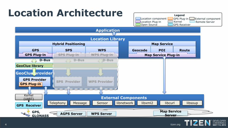
Location Architecture
Location Library
Map Service
Remote Server
External componentKernel
Open Source
Location component GPS Plug-in
GPS ReceiverLocation Plug-in
Legend
External Components
WPS ServerMap Service
ServerAGPS Server
Hybrid Positioning
WPSSPS
SPS Provider WPS Provider
SPS Plug-in WPS Plug-in
Kernel (UART)
Telephony libsoupSensorMessage libnetworkGPS Receiver
Geocode POI Route
Map Service Plug-in
GPS
GPS Plug-in
Application
D-Bus D-Bus
libxml2
GPS, GLONASS
GPS Provider
GPS Plug-in
GeoClue library
D-Bus
libcurl
GeoClue providers
tizen.org5
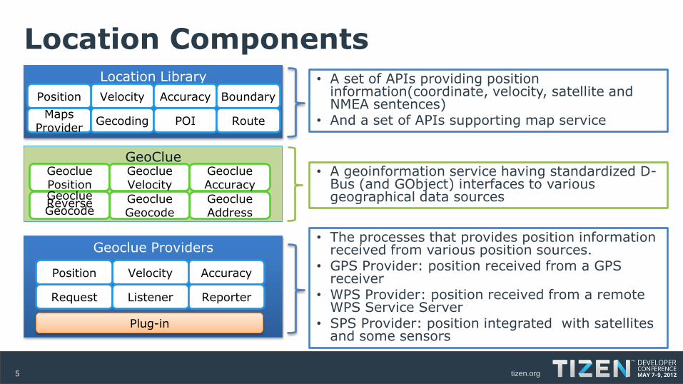
Location ComponentsLocation Library
Geoclue Providers
GeoClue
VelocityPosition Accuracy Boundary
MapsProvider
Gecoding POI Route
• A set of APIs providing position information(coordinate, velocity, satellite and NMEA sentences)
• And a set of APIs supporting map service
• A geoinformation service having standardized D-Bus (and GObject) interfaces to various geographical data sources
VelocityPosition Accuracy
Request Listener Reporter
GeocluePosition
GeoclueAddress
GeoclueVelocity
GeoclueGeocode
GeoclueReverseGeocode
GeoclueAccuracy
• The processes that provides position information received from various position sources.
• GPS Provider: position received from a GPS receiver
• WPS Provider: position received from a remote WPS Service Server
• SPS Provider: position integrated with satellites and some sensors
Plug-in
tizen.org6
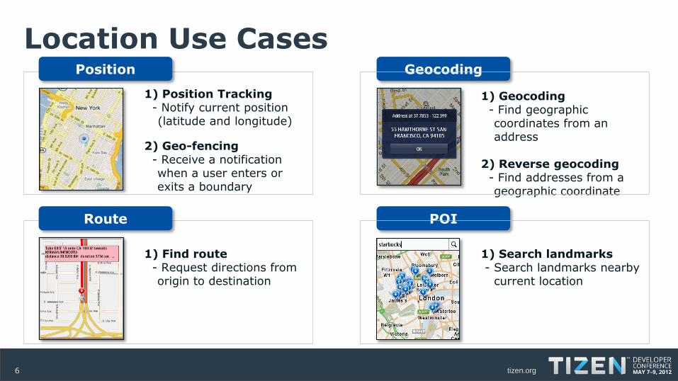
Location Use Cases Position
1) Position Tracking- Notify current position (latitude and longitude)
2) Geo-fencing- Receive a notification when a user enters or exits a boundary
Route
Geocoding
POI
1) Geocoding- Find geographic coordinates from an address
2) Reverse geocoding- Find addresses from a geographic coordinate
1) Find route- Request directions from origin to destination
1) Search landmarks- Search landmarks nearby
current location
tizen.org7
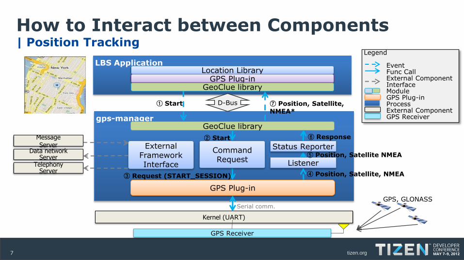
How to Interact between Components| Position Tracking
gps-manager
Kernel (UART)
GPS Plug-in
GeoClue library
Serial comm.
Command Request
External FrameworkInterface
Status Reporter
TelephonyServer
Data networkServer
MessageServer
② Start
③ Request (START_SESSION)
⑥ Response
GPS Receiver
LBS Application
① Start
Location Library
⑦ Position, Satellite, NMEA*
GPS Plug-in
④ Position, Satellite, NMEA
GPS, GLONASS
GeoClue library
Legend
EventFunc CallExternal Component InterfaceModule GPS Plug-inProcessExternal ComponentGPS Receiver
D-Bus
Listener⑤ Position, Satellite NMEA
tizen.org8
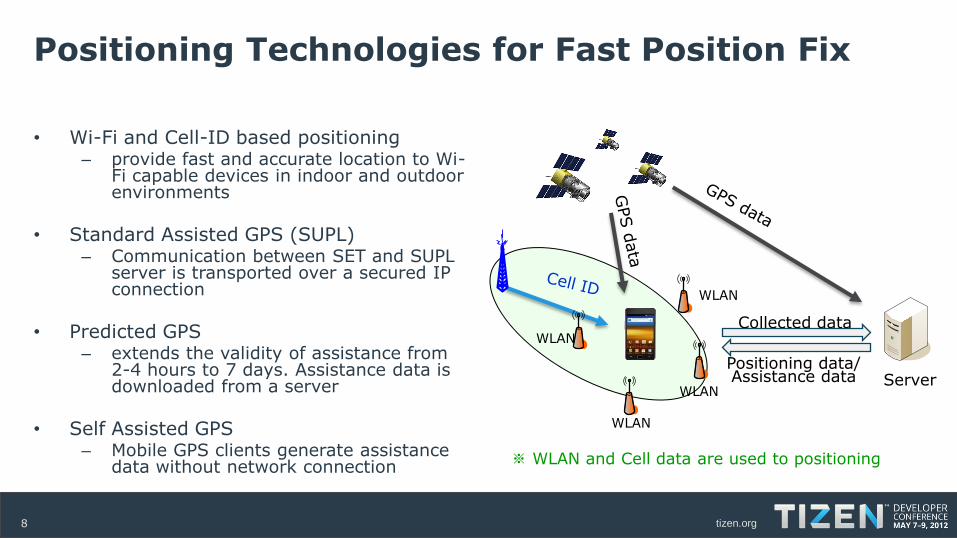
Positioning Technologies for Fast Position Fix
• Wi-Fi and Cell-ID based positioning– provide fast and accurate location to Wi-
Fi capable devices in indoor and outdoor environments
• Standard Assisted GPS (SUPL)– Communication between SET and SUPL
server is transported over a secured IP connection
• Predicted GPS– extends the validity of assistance from
2-4 hours to 7 days. Assistance data is downloaded from a server
• Self Assisted GPS– Mobile GPS clients generate assistance
data without network connection※ WLAN and Cell data are used to positioning
Server
Collected data
Positioning data/Assistance data
WLAN
WLAN
WLAN
WLAN
tizen.org9
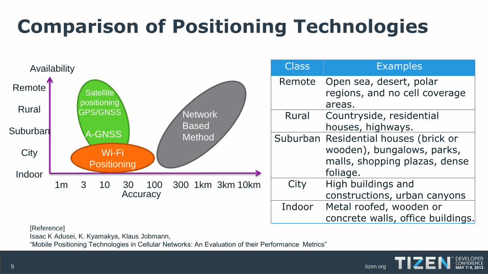
Comparison of Positioning Technologies
Class Examples
Remote Open sea, desert, polar regions, and no cell coverage areas.
Rural Countryside, residential houses, highways.
Suburban Residential houses (brick or wooden), bungalows, parks, malls, shopping plazas, dense foliage.
City High buildings and constructions, urban canyons
Indoor Metal roofed, wooden or concrete walls, office buildings.
[Reference]
Isaac K Adusei, K. Kyamakya, Klaus Jobmann,
“Mobile Positioning Technologies in Cellular Networks: An Evaluation of their Performance Metrics”
Accuracy
Availability
Satellite
positioning
GPS/GNSS
A-GNSS
Wi-Fi
Positioning
Network
Based
Method
1m 3 10 30 100 300 1km 3km 10km
Remote
Rural
Suburban
City
Indoor
tizen.org10
Summary
• Location is designed flexibly:– Platform developer can add and remove positioning plug-in– Platform developer can select the backend map service – A-GPS chipset vendor can develop easily gps-manager’s plug-in using Location
OAL(OEM Abstraction Layer) interfaces
• Hybrid positioning service– A user can select a positioning provider or various positioning providers.
• Positioning service is compatible with standard Assisted GPS– Assistance data service for GPS over the standard OMA Secure User Plan
Location(SUPL) protocol.

Thank you