Embed Size (px)
Citation preview

Overview of the State’s Settlement Proposal for
“Income and Proceeds” of the Public Land Trust Due the Office of Hawaiian Affairs
Settlement 1
Please send comments or questions to: [email protected]

Settlement:$200MM
OHA right to revenue:Constitution pro rata shareLegislation 20%DFS airport $136, state hospitals $126, state afford.
housing $36Litigation, 87, 01, 06, leg. duty Political question, sovereign immunity
2008 settlement signed:$200MM, KM 5, Kalaeloa, Hilo, $13MMNot enough community involvementRelease language ?Going forward provisions
Economy got bad 2009, 2010Settlement 2

Writ of mandamus fall 2010
Governor Abercrombie, David LouieReally want to do it?State’s offer:
$200MM - Kakaʻako Makai 10 parcels; 30 acres As isDue diligence: value, environmental, title, use, 2005 workOnly past due revenue owed to OHA, not overthrow claims
Legislative approval
If due diligence relatively ok, good settlement because:Can’t sue for it, only to compel legislature to addressDifficult to enforceNo right to interestSurrounding property is valuable & lots of future developmentLong term a good asset to turn over to future Native Hawaiian
GovernmentLow holding cost: no property taxes, income offsetNo waiver of other claimsLow downside if accepted
Settlement 3

Constitutional Provisions
• Section 4
The lands granted to the State of Hawaii by Section 5(b) of the Admission Act and pursuant to Article XVI, Section 7, of the State Constitution, excluding therefrom lands defined as "available lands" by Section 203 of the Hawaiian Homes Commission Act, 1920, as amended, shall be held by the State as a public trust for native Hawaiians and the general public.
• Section 6
The board of trustees of the Office of Hawaiian Affairs shall exercise power as provided by law: to manage and administer the proceeds from the sale or other disposition of the lands, natural resources, minerals and income derived from whatever sources for native Hawaiians and Hawaiians, including all income and proceeds from that pro rata portion of the trust referred to in section 4 of this article for native Hawaiians; to formulate policy relating to affairs of native Hawaiians and Hawaiians; and to exercise control over real and personal property set aside by state, federal or private sources and transferred to the board for native Hawaiians and Hawaiians. The board shall have the power to exercise control over the Office of Hawaiian Affairs through its executive officer, the administrator of the Office of Hawaiian Affairs, who shall be appointed by the board.
Settlement 4

State’s 2nd Proposal (Complete)December 2011
Settlement 5
Parcel
TMK AddressLandArea
(Acres)
Zoning Sq. Ft
DensityLimit
Height Limit
Ft
Fee Simple Per
Sq. FtLand Values*
A2-1-58-952-1-58-125
1011 Ala Moana Blvd & Kewalo Basin 5.082 WC 1.50 65 $158.00 $34,980,000
B 2-1-58-22-1-58- 35
123 ʻĀhui Street & 113 ʻĀhui Street
3.15 WC 1.50 65 $129.35 $17,750,000
C2-1-58-124,2-1-58-126 59 ʻĀhui Street & ʻĀhui Street 2.041 WC 1.50 65 $155.30 $13,820,000
D2-1-58-482-1-60-13 45 ʻĀhui Street; 53 ʻĀhui Street .938 WC 1.50 65 $181.20 $7,400,000
E 2-1-58-6 919 Ala Moana Blvd (AAFES) 2.22 MUZ 2.50 400** $179.10 $17,160,000
F 2-1-60-5 160 ʻĀhui Street 4.613 MUZ 2.00 200 $152.60 $30,660,000
G 2-1-60-6 160 Kōʻula Street 2.546 MUZ 2.00 200 $166.55 $18,470,000
I 2-1-15-53 Ala Moana Blvd 3.336 MUZ 2.50 200 $164.00 $23,900,000
K 2-1-60-1 End of ʻĀhui Street - Point Panic 1.584 WC 1.50 65 $165.55 $11,420,000
L 2-1-15-51 End of Keawe Street 5.224 MUZ .60 45 $96.35 $21,930,000
* Preliminary Valuations only, Not Full Appraisals ** Assumes Height Limit Change to 400'
Legend: WC = Waterfront Commercial Zone MUZ = Multiple Use Zone
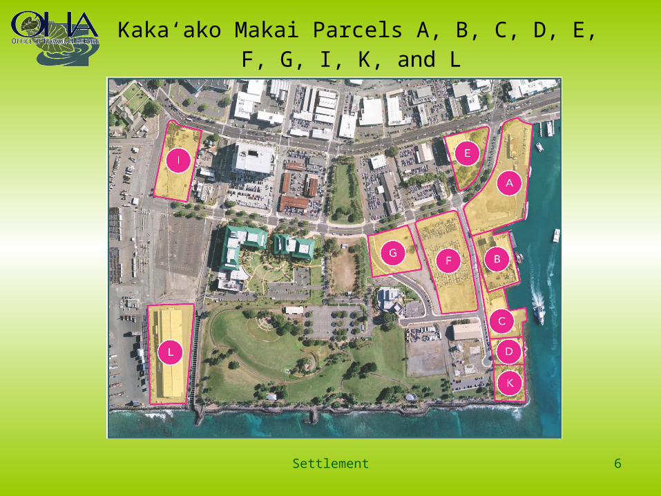
Kakaʻako Makai Parcels A, B, C, D, E, F, G, I, K, and L
Settlement 6

Parcels with Long Term Leases as of November 9, 2011
Settlement 7
Pacific Biosciences Research Center 2030
John Dominis 2042
Radio Tower 2035
Keiki Fishing Conservancy 2074
AAFES Building (DAGS) 2018
Honolulu Marine 2021

Parcel A: 1011 Ala Moana Boulevard and Kewalo BasinFisherman’s Wharf Restaurant and Open Lot
Settlement 8
ATotal Land Value: $34,980,000
TMK: 2-1-58-95, 125
Land Area: 5.082 acres
Zoning: WC
Density: 1.50
Height Limit: 65

Parcel B: 123 ʻĀhui Street and 113 ʻĀhui Street Boat Works
Settlement 9
BTotal Land Value: $17,750,000
TMK: 2-1-58-2, 35
Land Area: 3.15 acres
Zoning: WC
Density: 1.50
Height Limit: 65
Existing Long Term Lease with Honolulu Marine 2021

Parcel C: 59 ʻĀhui Street and ʻĀhui StreetVacant Lot
Settlement 10
Total Land Value: $13,820,000
TMK: 2-1-58-124, 126
Land Area: 2.041 acres
Zoning: WC
Density: 1.50
Height Limit: 65
15,000 sq. ft. leased to Keiki Fishing Conservancy (18%)
C

Parcel D: 45 ʻĀhui Street and 53 ʻĀhui Street
John Dominis Restaurant
Total Land Value: $7,400,000
TMK: 2-1-58-48; 2-1-60-13
Land Area: .938 acres
Zoning: WC
Density: 1.50
Height Limit: 65
Long Term Lease to John Dominis 2042
Settlement 11
D

Parcel E: 919 Ala Moana Boulevard
AAFES Building
Settlement 12
Total Land Value: $17,160,000
TMK: 2-1-58-6
Land Area: 2.22 acres
Zoning: MUZ
Density: 2.50
Height Limit: 400 (assuming height limit change)
Leased to State Department of Accounting and General Services 2018
E

Parcel F: 160 ʻĀhui Street
Settlement 13
F
Total Land Value: $30,660,000
TMK: 2-1-60-5
Land Area: 4.613 acres
Zoning: MUZ
Density: 2.00
Height Limit: 200

Parcel G: 160 Kōʻula Street
Settlement 14
G
Total Land Value: $18,470,000
TMK: 2-1-60-6
Land Area: 2.546 acres
Zoning: MUZ
Density: 2.00
Height Limit: 200
Kōʻula Street Extension

Parcel K: End of ʻĀhui StreetPoint Panic
Settlement 15
Total Land Value: $11,420,000
TMK: 2-1-60-1
Land Area: 1.584 acres
Zoning: WC
Density: 1.50
Height Limit: 65
K

Parcel I: Ala Moana Blvd
Settlement 16
Total Land Value: $23,900,000
TMK: 2-1-15-53
Land Area: 3.336 acres
Zoning: MUZ
Density: 2.50
Height Limit: 200
I

Parcel L: End of Keawe Street
Settlement 17
Total Land Value: $21,930,000
TMK: 2-1-15-51
Land Area: 5.224 acres
Zoning: MUZ
Density: 0.60
Height Limit: 45
Currently used as a shelter for homeless persons
Probably ceded lands
L

Summary of Conclusions
Settlement 18

Master Plan Proposed Profiles
Settlement 19

Ownership of Neighboring Parcels
Settlement 20
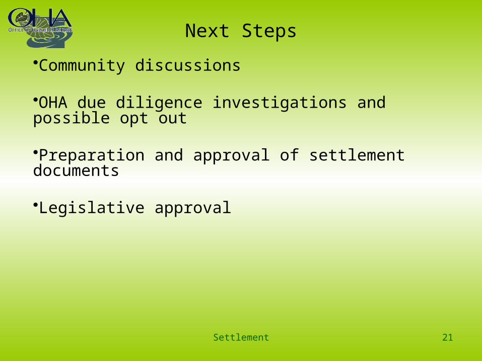
Next Steps
•Community discussions
•OHA due diligence investigations and possible opt out
•Preparation and approval of settlement documents
•Legislative approval
Settlement 21

Due Diligence Process
The Trustees of the Office of Hawaiian Affairs have a legal duty and fiduciary obligations to exercise utmost care in taking actions as a Board.
This Duty of Care includes performing due diligence prior to the acquisition of real property to ensure that any settlement mutually agreed to is prudent and in the best interest of the trust beneficiaries. Due diligence is the act of performing a reasonable investigation into the facts and circumstances of a transaction to ensure a full and complete understanding of the transaction and its impact on the Native Hawaiian Trust Fund.
• Identify legal barriers• Identify title issues• Identify environmental issues• Identify other issues
Settlement 22

Legislative Approval
• The State and OHA have reached an agreement in principle, subject to Legislative approval.
• This would finally and completely resolve any and all claims relating to OHA’s share of Public Land Trust revenues under Article XII, Sections 4 and 6 of the Constitution, from November 7, 1978 to July 1, 2012.
• The State and OHA agree that a $200 million approximate settlement amount represents a reasonable compromise of the disputed claims.
• The State would convey lands at Kakaʻako Makai to settle these claims. No cash would be paid.
Settlement 23

Historic Views of Kakaʻako Makai
Settlement 24

Historic Views of Kakaʻako Makai
Settlement 25
1817 map by Otto von Kotzebue, commander of the Russian ship Rurick, showingarea
*Note: a portion of the foreigner’s cemetery where Isaac Davis is believed to have been buried and that John Papa ‘Ī‘ī associates with “Kewalo” is located in the middle of the right side (labeled in Russian as “Kладбище”)

Historic Views of Kakaʻako Makai
Settlement 26
1825 map of “South Coast of Woahoo and Honorurou Harbour” by Lt. Charles Malden, showing area
(Registered Map No. 431, Hawai‘i Land Survey Division)

Historic Views of Kakaʻako Makai
Settlement 27
1855 map of Honolulu by Lt. Joseph de LaPasse of the French vessel, L`Eurydice; project area is adjacent to area labeled “Pecheries” (“Fishponds”) (map reprinted inFitzpatrick 1986:82-83)

Historic Views of Kakaʻako Makai
Settlement 28
1881 Oahu Island Government survey map by R. Covington, showing area
(Hawai‘i Land Survey Division, Registered Map No. 1381)

MAHALO
This concludes this presentation.
Settlement 29
Please send comments or questions to: [email protected]