Embed Size (px)
Citation preview
Outline of Italy's Geomorphology
Carlo Bartolini
Journal of the Virtual Explorer, Electronic Edition, ISSN 1441-8142, volume 36, paper 22In: (Eds.) Marco Beltrando, Angelo Peccerillo, Massimo Mattei, Sandro Conticelli, and
Carlo Doglioni, The Geology of Italy: tectonics and life along plate margins, 2010.
Download from: http://virtualexplorer.com.au/article/2010/216/italy-geomorphology
Click http://virtualexplorer.com.au/subscribe/ to subscribe to the Journal of the Virtual Explorer.Email [email protected] to contact a member of the Virtual Explorer team.
Copyright is shared by The Virtual Explorer Pty Ltd with authors of individual contributions. Individual authors mayuse a single figure and/or a table and/or a brief paragraph or two of text in a subsequent work, provided this work is ofa scientific nature, and intended for use in a learned journal, book or other peer reviewed publication. Copies of thisarticle may be made in unlimited numbers for use in a classroom, to further education and science. The VirtualExplorer Pty Ltd is a scientific publisher and intends that appropriate professional standards be met in any of itspublications.
Outline of Italy's GeomorphologyCarlo Bartolini
Dipartimento di Scienze della Terra, Università di Firenze Email: [email protected]
Abstract: The general setting of the Italian territory is illustrated by means of a DEM, a map of relief types and a mapof local relief analyzed at the 100 km2 grid scale.
Beside recent tectonic activity, geologically controlled relief forms result from regional uplift, a prerequisite oflithostructural landforms. In order to outline this prompter of morphogenesis as to the Italian region, a brief outlook onpresent day rock and surface uplift rates both in the Alps and in the Apennines follows.
The present uplift and denudation rates cope at large with the Alps relief. This is in line with the circumstance that theuplift pattern resembles that of apatite fission track age distribution, which would suggest long-term stability of theuplift process at the Ma timescale. Rates of denudation worked out with various methods in Northern and CentralApennines over timescales ranging from 10 to 106 years range from 0.2 to 0.5 mm/y.
Lithostructural and volcanic features are shown by means of a map prepared on purpose. The same applies tolandforms due to geomorphic processes. A description of Italy main geomorphic units is also included.
Citation: 2010. Outline of Italy's Geomorphology. In: (Eds.) Marco Beltrando, Angelo Peccerillo, Massimo Mattei,Sandro Conticelli, and Carlo Doglioni, Journal of the Virtual Explorer, volume 36, paper 22, doi: 10.3809/jvirtex.2010.00216
Journal of the Virtual Explorer, 2010Volume 36
Paper 22http://virtualexplorer.com.au/
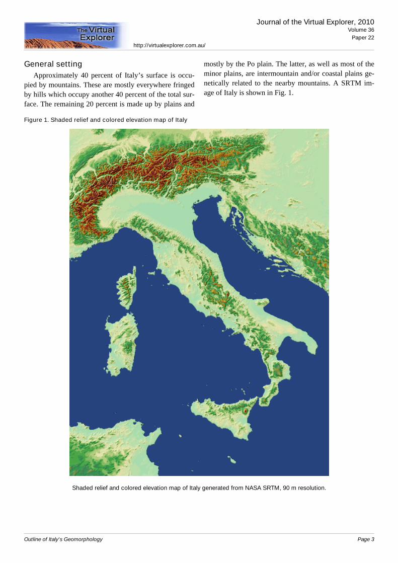
General settingApproximately 40 percent of Italy’s surface is occu-
pied by mountains. These are mostly everywhere fringedby hills which occupy another 40 percent of the total sur-face. The remaining 20 percent is made up by plains and
mostly by the Po plain. The latter, as well as most of theminor plains, are intermountain and/or coastal plains ge-netically related to the nearby mountains. A SRTM im-age of Italy is shown in Fig. 1.
Figure 1. Shaded relief and colored elevation map of Italy
Shaded relief and colored elevation map of Italy generated from NASA SRTM, 90 m resolution.
Journal of the Virtual Explorer, 2010Volume 36
Paper 22http://virtualexplorer.com.au/
Outline of Italy's Geomorphology Page 3
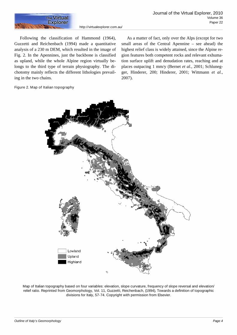
Following the classification of Hammond (1964),Guzzetti and Reichenbach (1994) made a quantitativeanalysis of a 230 m DEM, which resulted in the image ofFig. 2. In the Apennines, just the backbone is classifiedas upland, while the whole Alpine region virtually be-longs to the third type of terrain physiography. The di-chotomy mainly reflects the different lithologies prevail-ing in the two chains.
As a matter of fact, only over the Alps (except for twosmall areas of the Central Apennine – see ahead) thehighest relief class is widely attained, since the Alpine re-gion features both competent rocks and relevant exhuma-tion surface uplift and denudation rates, reaching and atplaces outpacing 1 mm/y (Bernet et al., 2001; Schluneg-ger, Hinderer, 200; Hinderer, 2001; Wittmann et al.,2007).
Figure 2. Map of Italian topography
Map of Italian topography based on four variables: elevation, slope curvature, frequency of slope reversal and elevation/relief ratio. Reprinted from Geomorphology, Vol. 11, Guzzetti, Reichenbach, (1994), Towards a definition of topographic
divisions for Italy, 57-74. Copyright with permission from Elsevier.
Journal of the Virtual Explorer, 2010Volume 36
Paper 22http://virtualexplorer.com.au/
Outline of Italy's Geomorphology Page 4
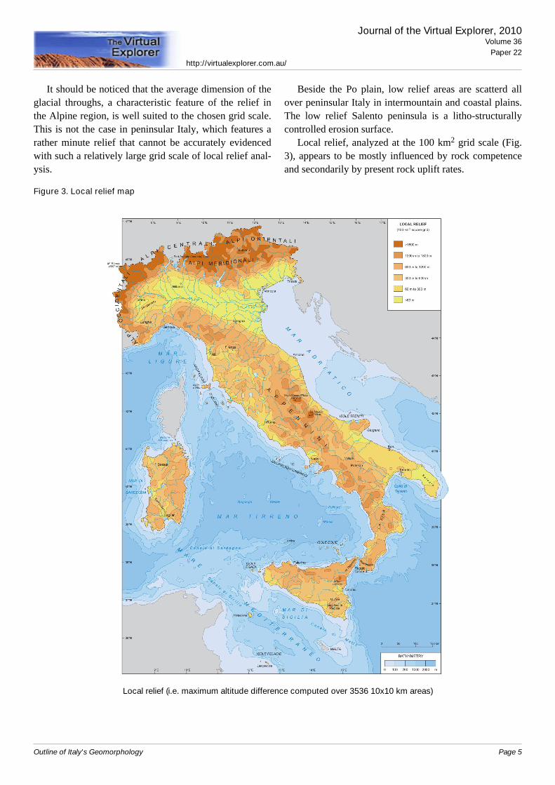
It should be noticed that the average dimension of theglacial throughs, a characteristic feature of the relief inthe Alpine region, is well suited to the chosen grid scale.This is not the case in peninsular Italy, which features arather minute relief that cannot be accurately evidencedwith such a relatively large grid scale of local relief anal-ysis.
Beside the Po plain, low relief areas are scatterd allover peninsular Italy in intermountain and coastal plains.The low relief Salento peninsula is a litho-structurallycontrolled erosion surface.
Local relief, analyzed at the 100 km2 grid scale (Fig.3), appears to be mostly influenced by rock competenceand secondarily by present rock uplift rates.
Figure 3. Local relief map
Local relief (i.e. maximum altitude difference computed over 3536 10x10 km areas)
Journal of the Virtual Explorer, 2010Volume 36
Paper 22http://virtualexplorer.com.au/
Outline of Italy's Geomorphology Page 5
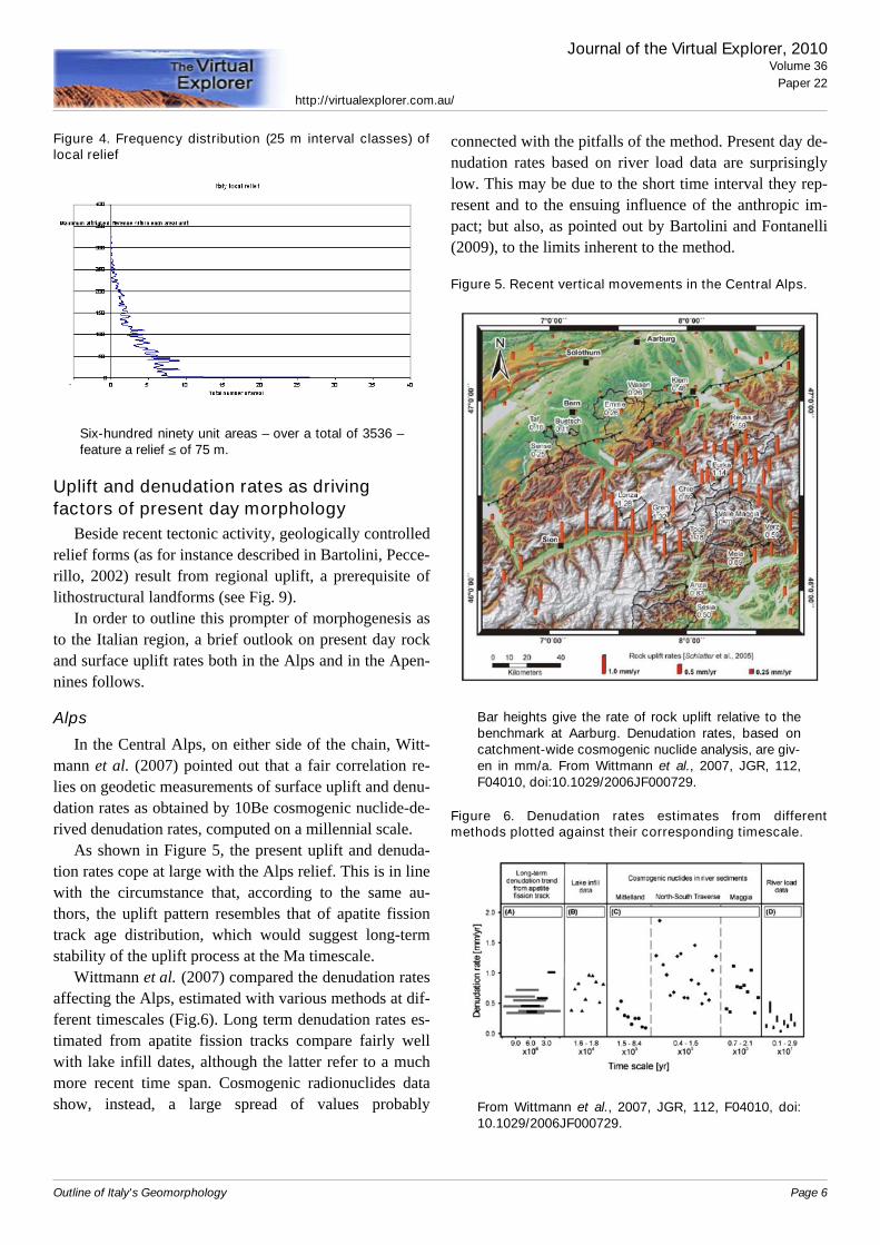
Figure 4. Frequency distribution (25 m interval classes) oflocal relief
Six-hundred ninety unit areas – over a total of 3536 –feature a relief ≤ of 75 m.
Uplift and denudation rates as drivingfactors of present day morphology
Beside recent tectonic activity, geologically controlledrelief forms (as for instance described in Bartolini, Pecce-rillo, 2002) result from regional uplift, a prerequisite oflithostructural landforms (see Fig. 9).
In order to outline this prompter of morphogenesis asto the Italian region, a brief outlook on present day rockand surface uplift rates both in the Alps and in the Apen-nines follows.
Alps
In the Central Alps, on either side of the chain, Witt-mann et al. (2007) pointed out that a fair correlation re-lies on geodetic measurements of surface uplift and denu-dation rates as obtained by 10Be cosmogenic nuclide-de-rived denudation rates, computed on a millennial scale.
As shown in Figure 5, the present uplift and denuda-tion rates cope at large with the Alps relief. This is in linewith the circumstance that, according to the same au-thors, the uplift pattern resembles that of apatite fissiontrack age distribution, which would suggest long-termstability of the uplift process at the Ma timescale.
Wittmann et al. (2007) compared the denudation ratesaffecting the Alps, estimated with various methods at dif-ferent timescales (Fig.6). Long term denudation rates es-timated from apatite fission tracks compare fairly wellwith lake infill dates, although the latter refer to a muchmore recent time span. Cosmogenic radionuclides datashow, instead, a large spread of values probably
connected with the pitfalls of the method. Present day de-nudation rates based on river load data are surprisinglylow. This may be due to the short time interval they rep-resent and to the ensuing influence of the anthropic im-pact; but also, as pointed out by Bartolini and Fontanelli(2009), to the limits inherent to the method.
Figure 5. Recent vertical movements in the Central Alps.
Bar heights give the rate of rock uplift relative to thebenchmark at Aarburg. Denudation rates, based oncatchment-wide cosmogenic nuclide analysis, are giv-en in mm/a. From Wittmann et al., 2007, JGR, 112,F04010, doi:10.1029/2006JF000729.
Figure 6. Denudation rates estimates from differentmethods plotted against their corresponding timescale.
From Wittmann et al., 2007, JGR, 112, F04010, doi:10.1029/2006JF000729.
Journal of the Virtual Explorer, 2010Volume 36
Paper 22http://virtualexplorer.com.au/
Outline of Italy's Geomorphology Page 6
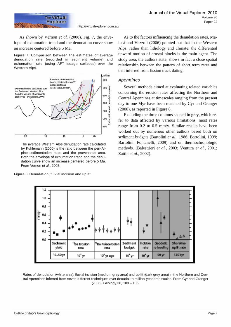
As shown by Vernon et al. (2008), Fig. 7, the enve-lope of exhumation trend and the denudation curve showan increase centered before 5 Ma.Figure 7. Comparison between the estimates of averagedenudation rate (recorded in sediment volume) andexhumation rate (using AFT isoage surfaces) over theWestern Alps.
The average Western Alps denudation rate calculatedby Kuhlemann (2000) is the ratio between the peri-Al-pine sedimentation rates and the provenance area.Both the envelope of exhumation trend and the denu-dation curve show an increase centered before 5 Ma.From Vernon et al., 2008.
As to the factors influencing the denudation rates, Ma-lusà and Vezzoli (2006) pointed out that in the WesternAlps, rather than lithology and climate, the differentialupward motion of crustal blocks is the main agent. Thestudy area, the authors state, shows in fact a close spatialrelationship between the pattern of short term rates andthat inferred from fission track dating.
Apennines
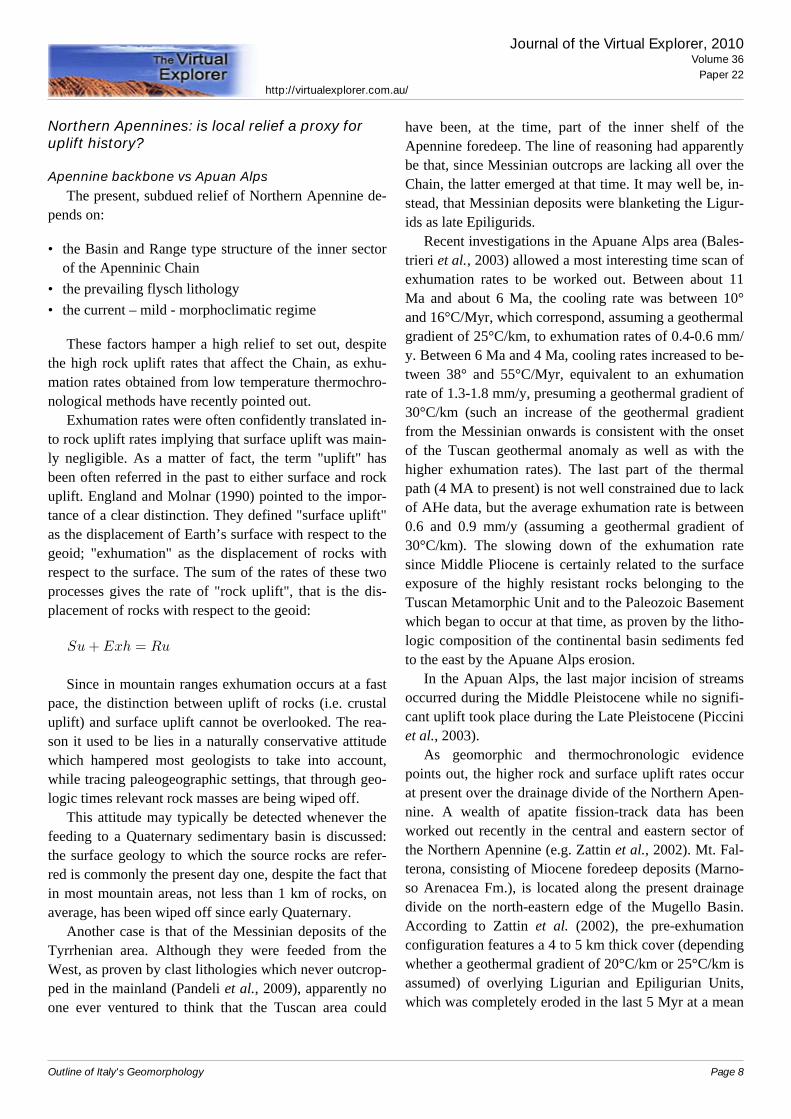
Several methods aimed at evaluating related variablesconcerning the erosion rates affecting the Northern andCentral Apennines at timescales ranging from the presentday to one Myr have been matched by Cyr and Granger(2008), as reported in Figure 8.
Excluding the three columns shaded in grey, which re-fer to data affected by various limitations, most ratesrange from 0.2 to 0.5 mm/y. Similar results have beenworked out by numerous other authors based both onsediment budgets (Bartolini et al., 1986; Bartolini, 1999;Bartolini, Fontanelli, 2009) and on thermochronologicmethods. (Balestrieri et al., 2003; Ventura et al., 2001;Zattin et al., 2002).
Figure 8. Denudation, fluvial incision and uplift.
Rates of denudation (white area), fluvial incision (medium grey area) and uplift (dark grey area) in the Northern and Cen-tral Apennines inferred from seven different techniques over decadal to million-year time scales. From Cyr and Granger
(2008), Geology 36, 103 – 106.
Journal of the Virtual Explorer, 2010Volume 36
Paper 22http://virtualexplorer.com.au/
Outline of Italy's Geomorphology Page 7
Northern Apennines: is local relief a proxy foruplift history?
Apennine backbone vs Apuan AlpsThe present, subdued relief of Northern Apennine de-
pends on:
• the Basin and Range type structure of the inner sectorof the Apenninic Chain
• the prevailing flysch lithology• the current – mild - morphoclimatic regime
These factors hamper a high relief to set out, despitethe high rock uplift rates that affect the Chain, as exhu-mation rates obtained from low temperature thermochro-nological methods have recently pointed out.
Exhumation rates were often confidently translated in-to rock uplift rates implying that surface uplift was main-ly negligible. As a matter of fact, the term "uplift" hasbeen often referred in the past to either surface and rockuplift. England and Molnar (1990) pointed to the impor-tance of a clear distinction. They defined "surface uplift"as the displacement of Earth’s surface with respect to thegeoid; "exhumation" as the displacement of rocks withrespect to the surface. The sum of the rates of these twoprocesses gives the rate of "rock uplift", that is the dis-placement of rocks with respect to the geoid:
Since in mountain ranges exhumation occurs at a fastpace, the distinction between uplift of rocks (i.e. crustaluplift) and surface uplift cannot be overlooked. The rea-son it used to be lies in a naturally conservative attitudewhich hampered most geologists to take into account,while tracing paleogeographic settings, that through geo-logic times relevant rock masses are being wiped off.
This attitude may typically be detected whenever thefeeding to a Quaternary sedimentary basin is discussed:the surface geology to which the source rocks are refer-red is commonly the present day one, despite the fact thatin most mountain areas, not less than 1 km of rocks, onaverage, has been wiped off since early Quaternary.
Another case is that of the Messinian deposits of theTyrrhenian area. Although they were feeded from theWest, as proven by clast lithologies which never outcrop-ped in the mainland (Pandeli et al., 2009), apparently noone ever ventured to think that the Tuscan area could
have been, at the time, part of the inner shelf of theApennine foredeep. The line of reasoning had apparentlybe that, since Messinian outcrops are lacking all over theChain, the latter emerged at that time. It may well be, in-stead, that Messinian deposits were blanketing the Ligur-ids as late Epiligurids.
Recent investigations in the Apuane Alps area (Bales-trieri et al., 2003) allowed a most interesting time scan ofexhumation rates to be worked out. Between about 11Ma and about 6 Ma, the cooling rate was between 10°and 16°C/Myr, which correspond, assuming a geothermalgradient of 25°C/km, to exhumation rates of 0.4-0.6 mm/y. Between 6 Ma and 4 Ma, cooling rates increased to be-tween 38° and 55°C/Myr, equivalent to an exhumationrate of 1.3-1.8 mm/y, presuming a geothermal gradient of30°C/km (such an increase of the geothermal gradientfrom the Messinian onwards is consistent with the onsetof the Tuscan geothermal anomaly as well as with thehigher exhumation rates). The last part of the thermalpath (4 MA to present) is not well constrained due to lackof AHe data, but the average exhumation rate is between0.6 and 0.9 mm/y (assuming a geothermal gradient of30°C/km). The slowing down of the exhumation ratesince Middle Pliocene is certainly related to the surfaceexposure of the highly resistant rocks belonging to theTuscan Metamorphic Unit and to the Paleozoic Basementwhich began to occur at that time, as proven by the litho-logic composition of the continental basin sediments fedto the east by the Apuane Alps erosion.
In the Apuan Alps, the last major incision of streamsoccurred during the Middle Pleistocene while no signifi-cant uplift took place during the Late Pleistocene (Picciniet al., 2003).
As geomorphic and thermochronologic evidencepoints out, the higher rock and surface uplift rates occurat present over the drainage divide of the Northern Apen-nine. A wealth of apatite fission-track data has beenworked out recently in the central and eastern sector ofthe Northern Apennine (e.g. Zattin et al., 2002). Mt. Fal-terona, consisting of Miocene foredeep deposits (Marno-so Arenacea Fm.), is located along the present drainagedivide on the north-eastern edge of the Mugello Basin.According to Zattin et al. (2002), the pre-exhumationconfiguration features a 4 to 5 km thick cover (dependingwhether a geothermal gradient of 20°C/km or 25°C/km isassumed) of overlying Ligurian and Epiligurian Units,which was completely eroded in the last 5 Myr at a mean
Journal of the Virtual Explorer, 2010Volume 36
Paper 22http://virtualexplorer.com.au/
Outline of Italy's Geomorphology Page 8
rate of 0.8 to 1 mm/y. Since geological data suggest thatlittle or no relief was present in the area between 5.0 and2.0 Ma BP, rock uplift rates should have been quite simi-lar during that period to the computed exhumation ratesof approximately 0.8 mm/y. Surface uplift was thereforenegligible. As a matter of fact, a residual veneer of Ligur-ids at places presently buried under the fluvial depositsboth in Mugello and in the nearby Casentino basin indi-cate that the 5 km thick Ligurids cover had not been com-pletely wiped out when the basin became the site of floodplain sedimentation, that is around 2.0 Ma. The high ex-humation rates occurring between 5.0 and 2.0 Ma despitethe prevailing low relief was made possible by the higherodibility of most lithotypes which make up the Ligur-ide Complex.
Conclusive remarks on local relief as a proxy ofpresent uplift rates
The slowing down of rock uplift rates in the Apuanarea, compared with the present chain divide, fits the wellestablished eastward-younging foredeep and synrift de-posits and the migration of the orogenic processes and re-lated features as well.
Despite the much lower rock uplift rates, the presentaverage altitude of the Apuan peaks (1500 to 1900 m) isvery close to that of the Apennine divide. As a matter offact, the higher rock uplift is here largely compensated bythe higher erodibility of the turbiditic sandstones whichmake up the Chain backbone. Because of the prevailinglow erodibility, the local relief of the Apuan Alps is tosuch an extent greater than that of the typical Apenninechain, to deserve their odd name whereby a crumble of“Alps” lies well within the Apennines.
Geomorphic featuresLithostructural features are widespread even when
looking at a small scale such as in Fig. 9. This is not sur-prising in a country which is mostly everywhere upliftingand where lithology strongly controls, at local scale, theerosion rates.
Volcanic features, connected with the ongoing and/orrecent magmatic activity, characterize only the centraland southern sectors of peninsular Italy and several largeand minor islands as well.
Virtually all morphogenic processes, including karstand eolic, left their footprint over the Country (Fig. 10).
Morphologic description of the geomorphicunits
The Alps
This mountain system forms a broad arc extendingfrom the Ligurian coast and the French Riviera to Austriaand Slovenia. The width of the belt is increasing east-ward; where the chain sharply bends around Piedmont,the width is approximately 150 km. Only one main rangeoccurs to the south of the Mont Blanc, while two broadlyparallel ranges may be found eastward, divided by theRhone-Rhine alignement. A remarkable feature is theasymmetry of the two watersheds, the southern beingsteeper than the northern. The difference is mostly due tothe lithologic control of the ongoing erosion rates asshown for instance by Vernon et al. (2008).
In the Central Alps the morphology is more complexand the width of the chain is some 300 km. In this areaand farther to the east the less deformed Southern Calca-reous Alps are fringing to the south the Chain proper.The peri-Adriatic or Insubric line marks the limit.
The core of the Alps is formed of exhumed Hercynianbasement rocks belonging to the European margin. Eitherside of the core, sedimentary rocks derived from Tetideansediments widely outcrop. Because of the low erodibilityof the basement rocks, all the highest peaks occur in thebasement massifs.
The main drainage network is mostly longitudinal tothe chain in the central sectors while on the Alpine mar-gins most valleys show a centripetal trend. This is espe-cially evident in the Southern Alps, where remnants oflongitudinal valleys have been incorporated in the presentsouthward trending drainage. Quite a few valleys appearmisfit due to river captures operated by southboundingrivers activated by the uplift. Glacial scouring of themain Alpine valleys led to the buildup of extensive mor-ainic arcs in the piedmont areas, where they fringe sever-al large lakes.
Journal of the Virtual Explorer, 2010Volume 36
Paper 22http://virtualexplorer.com.au/
Outline of Italy's Geomorphology Page 9
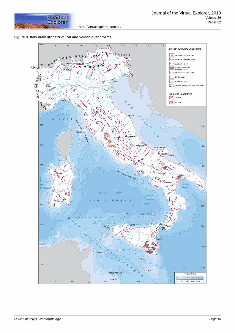
Figure 9. Italy main lithostructural and volcanic landforms.
Journal of the Virtual Explorer, 2010Volume 36
Paper 22http://virtualexplorer.com.au/
Outline of Italy's Geomorphology Page 10
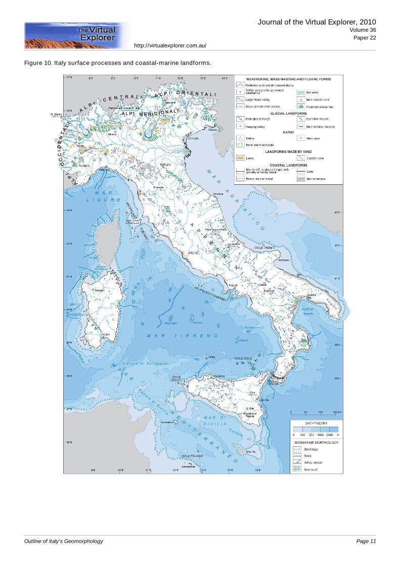
Figure 10. Italy surface processes and coastal-marine landforms.
Journal of the Virtual Explorer, 2010Volume 36
Paper 22http://virtualexplorer.com.au/
Outline of Italy's Geomorphology Page 11
The Po Valley
This is not actually a valley scoured by the Po riverbut a rather complex foredeep structure of both the Al-pine and the Apenninic chains, filled by mostly marinePliocene and Quaternary sediments and drained by the Poriver. The location of the river in the valley is largelystructurally controlled but also driven by the opposedthrust of the Alpine and Apenninic river sediments which
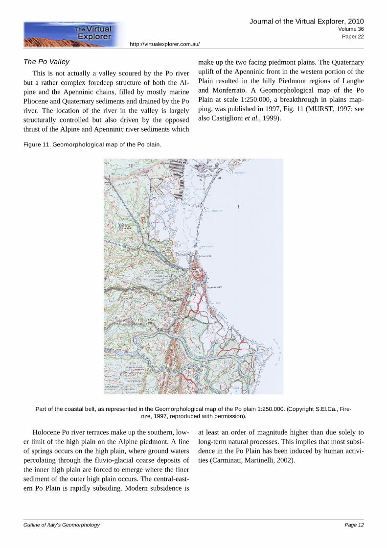
make up the two facing piedmont plains. The Quaternaryuplift of the Apenninic front in the western portion of thePlain resulted in the hilly Piedmont regions of Langheand Monferrato. A Geomorphological map of the PoPlain at scale 1:250.000, a breakthrough in plains map-ping, was published in 1997, Fig. 11 (MURST, 1997; seealso Castiglioni et al., 1999).
Figure 11. Geomorphological map of the Po plain.
Part of the coastal belt, as represented in the Geomorphological map of the Po plain 1:250.000. (Copyright S.El.Ca., Fire-nze, 1997, reproduced with permission).
Holocene Po river terraces make up the southern, low-er limit of the high plain on the Alpine piedmont. A lineof springs occurs on the high plain, where ground waterspercolating through the fluvio-glacial coarse deposits ofthe inner high plain are forced to emerge where the finersediment of the outer high plain occurs. The central-east-ern Po Plain is rapidly subsiding. Modern subsidence is
at least an order of magnitude higher than due solely tolong-term natural processes. This implies that most subsi-dence in the Po Plain has been induced by human activi-ties (Carminati, Martinelli, 2002).
Journal of the Virtual Explorer, 2010Volume 36
Paper 22http://virtualexplorer.com.au/
Outline of Italy's Geomorphology Page 12
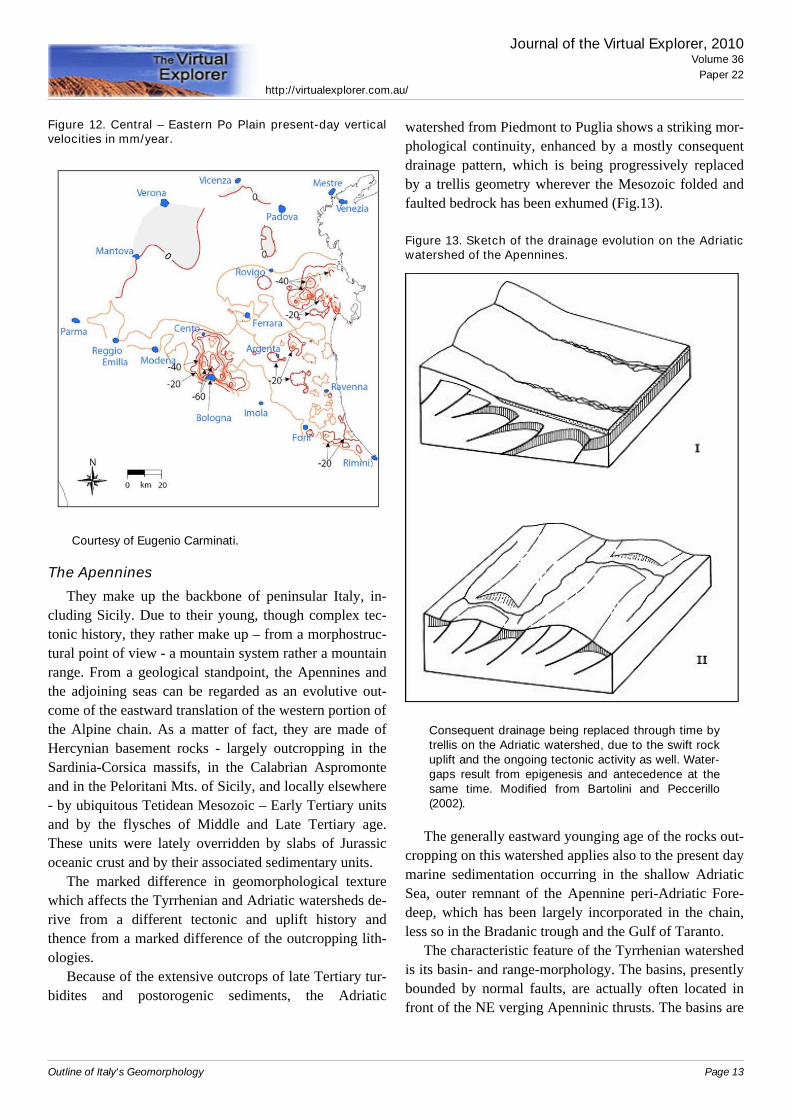
Figure 12. Central – Eastern Po Plain present-day verticalvelocities in mm/year.
Courtesy of Eugenio Carminati.
The Apennines
They make up the backbone of peninsular Italy, in-cluding Sicily. Due to their young, though complex tec-tonic history, they rather make up – from a morphostruc-tural point of view - a mountain system rather a mountainrange. From a geological standpoint, the Apennines andthe adjoining seas can be regarded as an evolutive out-come of the eastward translation of the western portion ofthe Alpine chain. As a matter of fact, they are made ofHercynian basement rocks - largely outcropping in theSardinia-Corsica massifs, in the Calabrian Aspromonteand in the Peloritani Mts. of Sicily, and locally elsewhere- by ubiquitous Tetidean Mesozoic – Early Tertiary unitsand by the flysches of Middle and Late Tertiary age.These units were lately overridden by slabs of Jurassicoceanic crust and by their associated sedimentary units.
The marked difference in geomorphological texturewhich affects the Tyrrhenian and Adriatic watersheds de-rive from a different tectonic and uplift history andthence from a marked difference of the outcropping lith-ologies.
Because of the extensive outcrops of late Tertiary tur-bidites and postorogenic sediments, the Adriatic
watershed from Piedmont to Puglia shows a striking mor-phological continuity, enhanced by a mostly consequentdrainage pattern, which is being progressively replacedby a trellis geometry wherever the Mesozoic folded andfaulted bedrock has been exhumed (Fig.13).
Figure 13. Sketch of the drainage evolution on the Adriaticwatershed of the Apennines.
Consequent drainage being replaced through time bytrellis on the Adriatic watershed, due to the swift rockuplift and the ongoing tectonic activity as well. Water-gaps result from epigenesis and antecedence at thesame time. Modified from Bartolini and Peccerillo(2002).
The generally eastward younging age of the rocks out-cropping on this watershed applies also to the present daymarine sedimentation occurring in the shallow AdriaticSea, outer remnant of the Apennine peri-Adriatic Fore-deep, which has been largely incorporated in the chain,less so in the Bradanic trough and the Gulf of Taranto.
The characteristic feature of the Tyrrhenian watershedis its basin- and range-morphology. The basins, presentlybounded by normal faults, are actually often located infront of the NE verging Apenninic thrusts. The basins are
Journal of the Virtual Explorer, 2010Volume 36
Paper 22http://virtualexplorer.com.au/
Outline of Italy's Geomorphology Page 13
typically offset from one another, as common in the ex-tensional settings worldwide. The drainage pattern isclosely controlled by the NNW trending tectonic struc-tures.
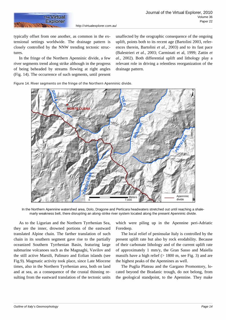
In the fringe of the Northern Apenninic divide, a fewriver segments trend along strike although in the progressof being beheaded by streams flowing at right angles(Fig. 14). The occurrence of such segments, until present
unaffected by the orographic consequence of the ongoinguplift, points both to its recent age (Bartolini 2003, refer-ences therein, Bartolini et al., 2003) and to its fast pace(Balestrieri et al., 2003; Carminati et al, 1999; Zattin etal., 2002). Both differential uplift and lithology play arelevant role in driving a relentless reorganization of thedrainage pattern.
Figure 14. River segments on the fringe of the Northern Apenninic divide.
In the Northern Apennine watershed area, Dolo, Dragone and Perticara headwaters stretched out until reaching a shale-marly weakness belt, there disrupting an along-strike river system located along the present Apenninic divide.
As to the Ligurian and the Northern Tyrrhenian Sea,they are the inner, drowned portions of the eastwardtranslated Alpine chain. The farther translation of suchchain in its southern segment gave rise to the partiallyoceanized Southern Tyrrhenian Basin, featuring largesubmarine volcanoes such as the Magnaghi, Vavilov andthe still active Marsili, Palinuro and Eolian islands (seeFig.9). Magmatic activity took place, since Late Miocenetimes, also in the Northern Tyrrhenian area, both on landand at sea, as a consequence of the crustal thinning re-sulting from the eastward translation of the tectonic units
which were piling up in the Apennine peri-AdriaticForedeep.
The local relief of peninsular Italy is controlled by thepresent uplift rate but also by rock erodability. Becauseof their carbonate lithology and of the current uplift rateof approximately 1 mm/y, the Gran Sasso and Maiellamassifs have a high relief (> 1800 m, see Fig. 3) and arethe highest peaks of the Apennines as well.
The Puglia Plateau and the Gargano Promontory, lo-cated beyond the Bradanic trough, do not belong, fromthe geological standpoint, to the Apennine. They make
Journal of the Virtual Explorer, 2010Volume 36
Paper 22http://virtualexplorer.com.au/
Outline of Italy's Geomorphology Page 14
up, instead, the emerged sector of the Southern ApennineForeland.
The variety of landscapes which make peninsular Italya fascinating place to visit and to live in is also due to thedifferent geologic histories which affected each singleportion of the region.
Sicily
The island may be considered as the East-West trend-ing southerly extension of the Apennines. The RagusaPlateau make up, here, the emerged sector of the Apen-nine Foreland, which contributes to the triangular shapeof the Island.
A striking feature is obviously made up by the EtnaVolcano. Its location, on thickened crust on the outer sideof the chain, is not obvious; it is connected to a sinistralwrench fault responsible also for the shift affecting theAspromonte versus Peloritani Mts. and of Sicily's insu-larity as well. The extinct volcano of Mt. Vulture, locatedon the inner fringe of the Bradanic Trough, has a similar– odd - structural setting.
Sardinia
This island is - along with its northerly sister, Corsica,and like the Aspromonte and Peloritani Mts. - a southeas-terly translated portion of Hercynian basement rocks sup-porting, at places, relicts of their highly tectonized AlpineMesozoic and Tertiary cover. Remnants of the Paleozoicplanation surface carved in the Hercynian basement maybe traced here and there (see, for instance, Bartolini, Pec-cerillo, 2002).
The Campidano Graben, filled with Pliocene andQuaternary sediments, is a large extensional featurepointing out that Sardinia shares, at present, the samestructural setting of the whole Tyrrhenian area.
AcknowledgementsS.El.Ca., Florence, is gratefully acknowledged for
working out the images of Figs. 3, 9, 10. Dr. Minja Ku-kavicic kindly provided the image of Fig. 1.
Journal of the Virtual Explorer, 2010Volume 36
Paper 22http://virtualexplorer.com.au/
Outline of Italy's Geomorphology Page 15
References
Balestrieri, M.L., Bernet, M., Brandon, M.T., Picotti, V., Reiners,P., Zattin M., 2003. Pliocene and Pleistocene exhumationand uplift of two key areas of the Northern Apennines.Quaternary International, 101-102, 67-74.10.1016/S1040-6182(02)00089-7
Bartolini C, 1999. An overview of Pliocene to present-day upliftand denudation rates in the Northern Apennine. In Uplift,Erosion and Stability: Perspectives on Long-TermLandscape Development, Smith, B.J., Whalley, W.B.,Warke, P.A. (eds.). Geological Society, London, Sp. Publ.162, 119 - 125.
Bartolini, C., 2003. When did the Northern Apennine become amountain chain? Quaternary International, 101-102, 75 –80.10.1016/S1040-6182(02)00090-3
Bartolini, C., Caputo R., Pieri M., 1996. Pliocene - Quaternarysedimentation in the Northern Apennine Foredeep andrelated denudation. Geological Magazine 133 (3), 255 -273.10.1017/S0016756800009006
Bartolini, C., D’Agostino, N., Dramis F., 2003. Topography,exhumation, and drainage network evolution of theApennines. Episodes, 26 (3), 212-216.
Bartolini, C., Fontanelli, K., 2009. Present versus long termsediment yield to the Adriatic Sea and the reliability ofsediment yield data. Ital. J. Geosci., 128, 655-667.
Bartolini, C., Peccerillo, A., 2002. I fattori geologici delle formedel rilievo. Lezioni di geomorfologia strutturale. IIEd.Pitagora Editrice Bologna, 221 pp.
Bernet, M., Zattin, M., Garver, J.I., Brandon, M.T., Vance, J.A.,2001. Steady-state exhumation of the European Alps.Geology, 29 (1),35-38.10.1130/0091-7613(2001)029<0035:SSEOTE>2.0.CO;2
Carminati, E., Giunchi, C., Argnani, A., Sabadini R., FernandezM., 1999. Plio-Quaternary vertical motion of the NorthernApennines: insights from dynamic modeling. Tectonics, 18(4), 703-718.10.1029/1999TC900015
Carminati, E., Martinelli, G., 2002. Subsidence rates in the PoPlain, northern Italy: the relative impact of natural andanthropogenic causation. Eng. Geol., 66, 241-255.10.1016/S0013-7952(02)00031-5
Castiglioni, G.B., Biancotti, A., Bondesan, M., Cortemiglia,G.C., Elmi, C., Favero, V., Gasperi, G., Marchetti, G.,Orombelli, G., Pellegrini, B., Tellini, C., 1999.Geomorphological map of the Po Plain, Italy, at a scale of1:250.000. Earth Surface Processes and Landforms, 24,1115-1120.
Cyr, A.J., Granger, D.E., 2008. Dynamic equilibrium amongerosion, river incision and coastal uplift in the Northern andCentral Apennines, Italy. Geology 36, 103 – 106.10.1130/G24003A.1
England, P. and Molnar, P., 1990. Surface uplift, uplift of rocksand exhumation of rocks. Geology, 18,1173-1177.10.1130/0091-7613(1990)018<1173:SUUORA>2.3.CO;2
Guzzetti, F., Reichenbach, P., 1994. Towards a definition oftopographic divisions for Italy. Geomorphology, 11,57-74.10.1016/0169-555X(94)90042-6
Hammond, E.H., 1964. Analysis of properties in land formgeography: an application to broad scale land formmapping. Ann. Ass. Am. Geogr., 54, 11-19.10.1111/j.1467-8306.1964.tb00470.x
Hinderer, M, 2001. Late Quaternary denudation of the Southernwatershed of the Alps, valley and lake fillings and modernriver loads. Geodinamica Acta, 14, 231-263.10.1016/S0985-3111(01)01070-1
Kuhlemann, J., 2000. Post-collisional sediment budget ofcircum-Alpine basins (Central Europe). Mem. Sci. Geol.Padova, 52, 1–91.
Malusà, M.G., Vezzoli, G., 2006. Interplay between erosion andtectonics in the Western Alps. Terra Nova, 18,104-108.10.1111/j.1365-3121.2006.00669.x
M.U.R.S.T., 1997. Carta geomorfologica della Pianura Padana/Geomorphological map of Po Plain. S.El.Ca., Firenze, Italy,3 sheets, scale 1:250,000.
Pandeli, E., Bartolini, C., Dini, A., Antolini, E., 2009. New dataon the paleogeography of Southern Tuscany (Italy) sinceLate Miocene time. Int J Earth Sci (Geol Rundsch), DOI10.1007/s00531-009-0463-z.10.1007/s00531-009-0463-z
Piccini, L., Drysdale, R. and Heijnis, H., 2003. Karst morhologyand cave sediments as indicators of the uplift history in theAlpi Apuane (Tuscany, Italy): Quaternary International,101-102, 219-227.10.1016/S1040-6182(02)00104-0
Schlunegger, F., Hinderer, M., 2001. Crustal uplift in the Alps:why the drainage pattern matters. Terra Nova, 13,425-432.10.1046/j.1365-3121.2001.00374.x
Vernon, A.J, van der Beek, P.A., Sinclair, H.D, Rahn M.K, 2008.Increase in late Neogene denudation of the European Alpsconfirmed by analysis of a fission-track thermochronologydatabase. Earth and Planetary Science Letters 270, 316–32910.1016/j.epsl.2008.03.053
Ventura, B., Pini, G.A., Zuffa, G.G., 2001. Thermal history andexhumation of the Northern Apennines (Italy): evidencefrom combined apatite fission track and vitrinite reflectancedata from foreland basins sediments. Basin Res., 13,1-19.10.1046/j.0950-091x.2001.00159.x
Wittmann, H., von Blanckenburg, F., Kruesmann,T., Norton, K.,P., Kubik, P.W., 2007. Relation between rock uplift anddenudation from cosmogenic nuclides in river sediment inthe Central Alps of Switzerland. Journal of GeophysicalResearch, 112, F04010,10.1029/2006JF000729
Journal of the Virtual Explorer, 2010Volume 36
Paper 22http://virtualexplorer.com.au/
Outline of Italy's Geomorphology Page 16
Zattin, M., Ricotti, V., Zuffa, G.G., 2002. Fission-trackreconstruction of the front of the Northern Apennine thrustwedge and overlying Ligurian Unit. Am. Jour. Sci., 302, 346- 379.10.2475/ajs.302.4.346
Journal of the Virtual Explorer, 2010Volume 36
Paper 22http://virtualexplorer.com.au/
Outline of Italy's Geomorphology Page 17