Embed Size (px)
Citation preview
Review of the Air Force Academy No 1 (31) 2016
85
OUTDOOR HYBRID LOCATION TRACKING SYSTEM WITH REMOTE MONITORING
Cristinel GAVRILĂ, Eleonora JELESCU, Marian ALEXANDRUTransilvania University, Braşov, Romania
DOI: 10.19062/1842-9238.2016.14.1.12
Abstract: A hybrid location and tracking system designed for near real-time location monitoring of persons or objects in an outdoor environment is presented in this paper. The proposed system follows a client-server architecture, which confers flexibility and modularity characteristics. The client is represented by a System-on-chip (SOC) device, namely Raspberry Pi, equipped with a Global Positioning System (GPS) module and an USB 3G modem, configuration which ensures both localization and 3G (the 3rd Generation of Mobile Communications) capabilities. This approach provides three mechanisms for retrieving the current location: based on the GPS module, based on 3G triangulation and based on the serving cell location, hence the hybrid characteristic of the system. The remote monitoring feature is ensured by a server which can be accessed over the internet. Its purpose is to host the database in which the tracking information is stored and to provide a reliable web framework which ensures that end-users can access this information remotely, via a dedicated web-page or a smartphone application.
Keywords: Localization, 3G, GPS, RSSI based Triangulation, Raspberry PI.
1. INTRODUCTION
In the past few years the market of localization systems grew considerable mainly due to its applicability in a large array of domains covering both enterprise and home environments. Advanced tracking technologies and systems have been successfully used in fields such as automotive, medicine, geography or biology in the pursue of retrieving detailed insights in terms of time and space location of objects, people or animals. The most popular tracking technology is by far the GPS, but there are many other technologies which can be used, such as RFID (Radio Frequency Identification), GSM/UMTS (Global System for Mobile Communications/Universal Mobile Telecommunications System), wireless Ethernet [1], [2], [3], or ultrasonic systems (for a very precise localization), each having a distinct set of advantages dependent on the environment in which they are used.
In this paper a fully automated location tracking system is presented, capable of near real-time location retrieval and remote monitoring. Its main advantage compared to other existing implementations [4], [5] consists in the mechanisms used for determining the location which make use of both GPS and 3G technologies.
The default mechanism, and the most accurate, is based on the GPS module, which provides data related to the current location in NMEA (National Marine Electronics Association) format. If GPS signal is not available, a fallback mechanism is used, based on triangulation.
The USB 3G modem provides cell information such as: Mobile Network Code (MNC), Location Area Code (LAC), cell id (CID) and Received Signal Strength Indicator (RSSI), making it possible to retrieve the coordinates of the cell. If the coordinates of the serving cell and neighboring cells are available, a RSSI triangulation algorithm can be applied to determine the current location. If information related to the neighboring cells is not available, then the location of the serving cell is reported as current location.
Outdoor Hybrid Location Tracking System With Remote Monitoring
86
This hybrid approach increases the location tracking device reliability, ensuring that, even if the GPS module is malfunctioning, the location can still be retrieved with the cost of a diminished accuracy. After the location retrieval step, the data is formatted and sent to the server which inserts it into a MySQL database. The server is also responsible with providing the necessary web framework for remote monitoring and end-user access management. Each end-user has an individual account and each account is mapped to one or more location tracking devices, thus ensuring that each end-user can access only the data related to his own device(s).
The system provides two possibilities for remote monitoring: via a web page and via an Android based application, both offering the same array of services, amongst them being location history preview, last reported location preview and navigation to last reported location.
2. SYSTEM ARCHITECTURE AND DESCRIPTION
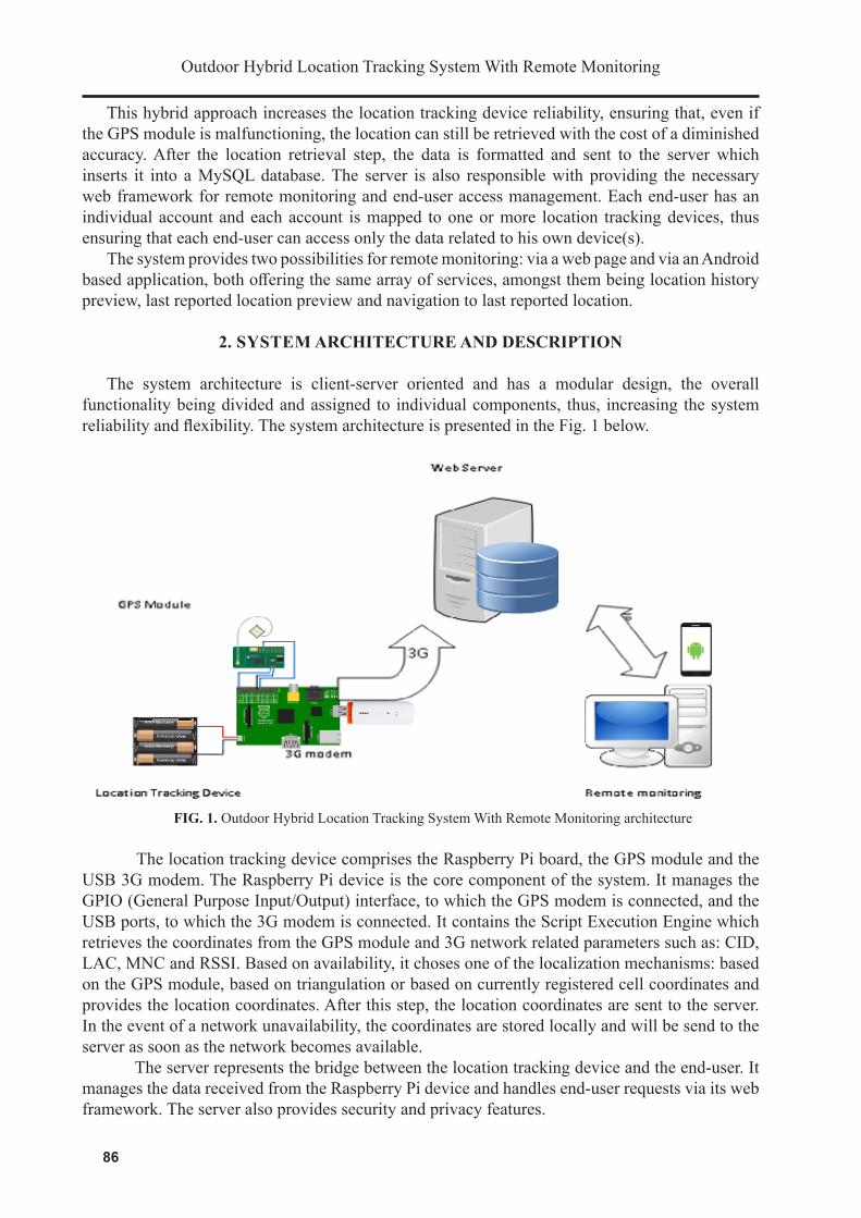
The system architecture is client-server oriented and has a modular design, the overall functionality being divided and assigned to individual components, thus, increasing the system reliability and flexibility. The system architecture is presented in the Fig. 1 below.
FIG. 1. Outdoor Hybrid Location Tracking System With Remote Monitoring architecture
The location tracking device comprises the Raspberry Pi board, the GPS module and the USB 3G modem. The Raspberry Pi device is the core component of the system. It manages the GPIO (General Purpose Input/Output) interface, to which the GPS modem is connected, and the USB ports, to which the 3G modem is connected. It contains the Script Execution Engine which retrieves the coordinates from the GPS module and 3G network related parameters such as: CID, LAC, MNC and RSSI. Based on availability, it choses one of the localization mechanisms: based on the GPS module, based on triangulation or based on currently registered cell coordinates and provides the location coordinates. After this step, the location coordinates are sent to the server. In the event of a network unavailability, the coordinates are stored locally and will be send to the server as soon as the network becomes available.
The server represents the bridge between the location tracking device and the end-user. It manages the data received from the Raspberry Pi device and handles end-user requests via its web framework. The server also provides security and privacy features.
87
Review of the Air Force Academy No 1 (31) 2016
By analyzing each request, it is able to determine whether the request came from a trusted device or end-user, in which case the request is processed, or it came from an unknown source, when the request is rejected. The privacy feature is ensured by providing the end-user only data related to his associated device(s).
The remote monitoring service provides, for the end-user, the means for accessing information related to his associated location tracking device(s). This can be achieved either by using the dedicated web interface or by using an Android based application. Both approaches offer the same functionality and it is up to the end-user to decide which one to use. Amongst the information which can be retrieved via the remote monitoring service are the last reported location of the location tracking device and a history of previously reported locations.
3. THE LOCATION TRACKING DEVICE
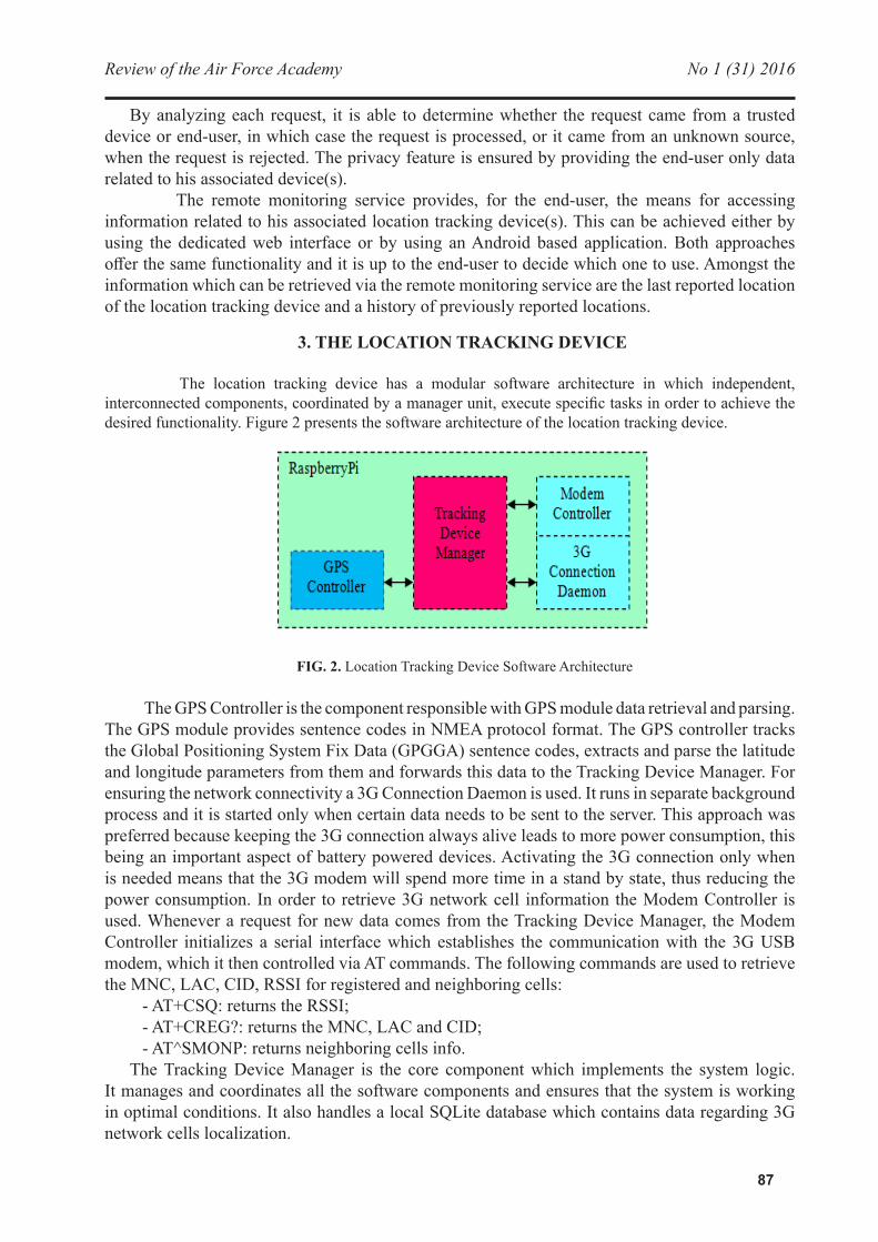
The location tracking device has a modular software architecture in which independent, interconnected components, coordinated by a manager unit, execute specific tasks in order to achieve the desired functionality. Figure 2 presents the software architecture of the location tracking device.
FIG. 2. Location Tracking Device Software Architecture
The GPS Controller is the component responsible with GPS module data retrieval and parsing. The GPS module provides sentence codes in NMEA protocol format. The GPS controller tracks the Global Positioning System Fix Data (GPGGA) sentence codes, extracts and parse the latitude and longitude parameters from them and forwards this data to the Tracking Device Manager. For ensuring the network connectivity a 3G Connection Daemon is used. It runs in separate background process and it is started only when certain data needs to be sent to the server. This approach was preferred because keeping the 3G connection always alive leads to more power consumption, this being an important aspect of battery powered devices. Activating the 3G connection only when is needed means that the 3G modem will spend more time in a stand by state, thus reducing the power consumption. In order to retrieve 3G network cell information the Modem Controller is used. Whenever a request for new data comes from the Tracking Device Manager, the Modem Controller initializes a serial interface which establishes the communication with the 3G USB modem, which it then controlled via AT commands. The following commands are used to retrieve the MNC, LAC, CID, RSSI for registered and neighboring cells:
- AT+CSQ: returns the RSSI; - AT+CREG?: returns the MNC, LAC and CID; - AT^SMONP: returns neighboring cells info.The Tracking Device Manager is the core component which implements the system logic.
It manages and coordinates all the software components and ensures that the system is working in optimal conditions. It also handles a local SQLite database which contains data regarding 3G network cells localization.
Outdoor Hybrid Location Tracking System With Remote Monitoring
88
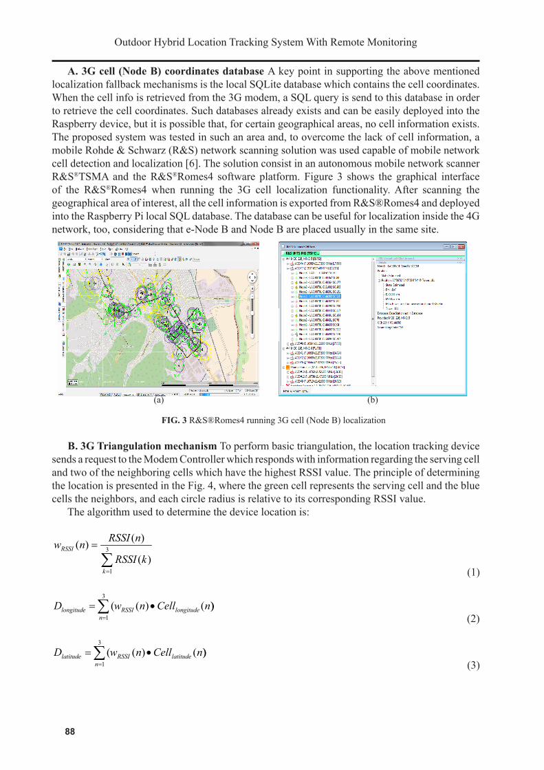
A. 3G cell (Node B) coordinates database A key point in supporting the above mentioned localization fallback mechanisms is the local SQLite database which contains the cell coordinates. When the cell info is retrieved from the 3G modem, a SQL query is send to this database in order to retrieve the cell coordinates. Such databases already exists and can be easily deployed into the Raspberry device, but it is possible that, for certain geographical areas, no cell information exists. The proposed system was tested in such an area and, to overcome the lack of cell information, a mobile Rohde & Schwarz (R&S) network scanning solution was used capable of mobile network cell detection and localization [6]. The solution consist in an autonomous mobile network scanner R&S®TSMA and the R&S®Romes4 software platform. Figure 3 shows the graphical interface of the R&S®Romes4 when running the 3G cell localization functionality. After scanning the geographical area of interest, all the cell information is exported from R&S®Romes4 and deployed into the Raspberry Pi local SQL database. The database can be useful for localization inside the 4G network, too, considering that e-Node B and Node B are placed usually in the same site.
(a) (b)
FIG. 3 R&S®Romes4 running 3G cell (Node B) localization
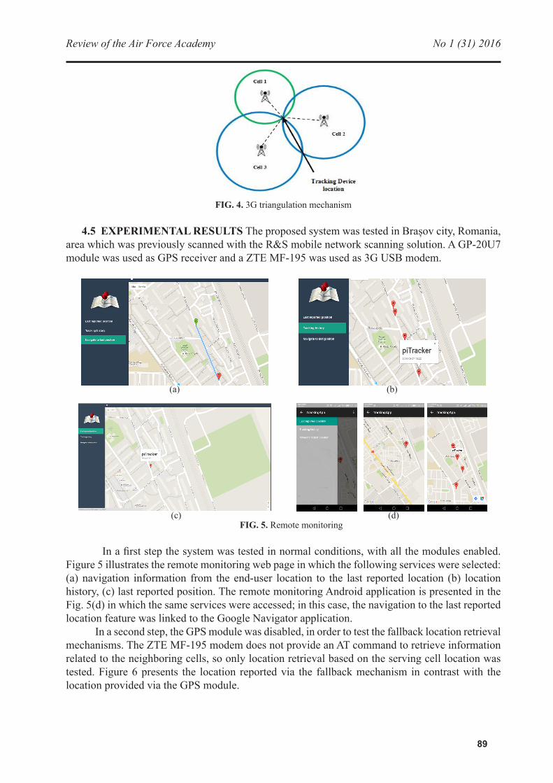
B. 3G Triangulation mechanism To perform basic triangulation, the location tracking device sends a request to the Modem Controller which responds with information regarding the serving cell and two of the neighboring cells which have the highest RSSI value. The principle of determining the location is presented in the Fig. 4, where the green cell represents the serving cell and the blue cells the neighbors, and each circle radius is relative to its corresponding RSSI value.
The algorithm used to determine the device location is:
∑=
= 3
1)(
)()(
k
RSSI
kRSSI
nRSSInw
(1)
))()((3
1nCellnwD longitudeRSSI
nlongitude •=∑
= (2)
))()((3
1nCellnwD latitudeRSSI
nlatitude •=∑
= (3)
89
Review of the Air Force Academy No 1 (31) 2016
FIG. 4. 3G triangulation mechanism
4.5 EXPERIMENTAL RESULTS The proposed system was tested in Brașov city, Romania, area which was previously scanned with the R&S mobile network scanning solution. A GP-20U7 module was used as GPS receiver and a ZTE MF-195 was used as 3G USB modem.
(a) (b)
(c) (d)
FIG. 5. Remote monitoring In a first step the system was tested in normal conditions, with all the modules enabled.
Figure 5 illustrates the remote monitoring web page in which the following services were selected: (a) navigation information from the end-user location to the last reported location (b) location history, (c) last reported position. The remote monitoring Android application is presented in the Fig. 5(d) in which the same services were accessed; in this case, the navigation to the last reported location feature was linked to the Google Navigator application.
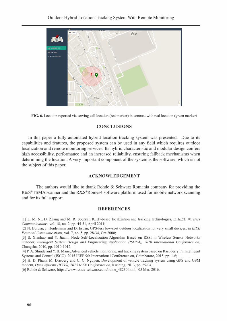
In a second step, the GPS module was disabled, in order to test the fallback location retrieval mechanisms. The ZTE MF-195 modem does not provide an AT command to retrieve information related to the neighboring cells, so only location retrieval based on the serving cell location was tested. Figure 6 presents the location reported via the fallback mechanism in contrast with the location provided via the GPS module.
Outdoor Hybrid Location Tracking System With Remote Monitoring
90
FIG. 6. Location reported via serving cell location (red marker) in contrast with real location (green marker)
CONCLUSIONS
In this paper a fully automated hybrid location tracking system was presented. Due to its capabilities and features, the proposed system can be used in any field which requires outdoor localization and remote monitoring services. Its hybrid characteristic and modular design confers high accessibility, performance and an increased reliability, ensuring fallback mechanisms when determining the location. A very important component of the system is the software, which is not the subject of this paper.
ACKNOWLEDGEMENT
The authors would like to thank Rohde & Schwarz Romania company for providing the R&S®TSMA scanner and the R&S®Romes4 software platform used for mobile network scanning and for its full support.
REFERENCES
[1] L. M. Ni, D. Zhang and M. R. Souryal, RFID-based localization and tracking technologies, in IEEE Wireless Communications, vol. 18, no. 2, pp. 45-51, April 2011;[2] N. Bulusu, J. Heidemann and D. Estrin, GPS-less low-cost outdoor localization for very small devices, in IEEE Personal Communications, vol. 7, no. 5, pp. 28-34, Oct 2000;[3] S. Xianhao and Y. Jiazhi, Node Self-Localization Algorithm Based on RSSI in Wireless Sensor Networks Outdoor, Intelligent System Design and Engineering Application (ISDEA), 2010 International Conference on, Changsha, 2010, pp. 1010-1012;[4] P. A. Shinde and Y. B. Mane, Advanced vehicle monitoring and tracking system based on Raspberry Pi, Intelligent Systems and Control (ISCO), 2015 IEEE 9th International Conference on, Coimbatore, 2015, pp. 1-6;[5] H. D. Pham, M. Drieberg and C. C. Nguyen, Development of vehicle tracking system using GPS and GSM modem, Open Systems (ICOS), 2013 IEEE Conference on, Kuching, 2013, pp. 89-94,[6] Rohde & Schwarz, https://www.rohde-schwarz.com/home_48230.html, 05 Mar. 2016.