Embed Size (px)
Citation preview
Outcrop Lithostratigraphy and Petrophysics of the Middle Devonian Marcellus Shale in
West Virginia and Adjacent States
Margaret E. Walker-Milani
THESIS
submitted to the
College of Arts and Sciences
at West Virginia University
in partial fulfillment of the requirements
for the degree of
Master of Science
in Geology
Richard Smosna, Ph.D., Chair
Timothy Carr, Ph.D.
John Renton, Ph.D.
Kathy Bruner, Ph.D.
Department of Geology and Geography
Morgantown, West Virginia
2011
ii
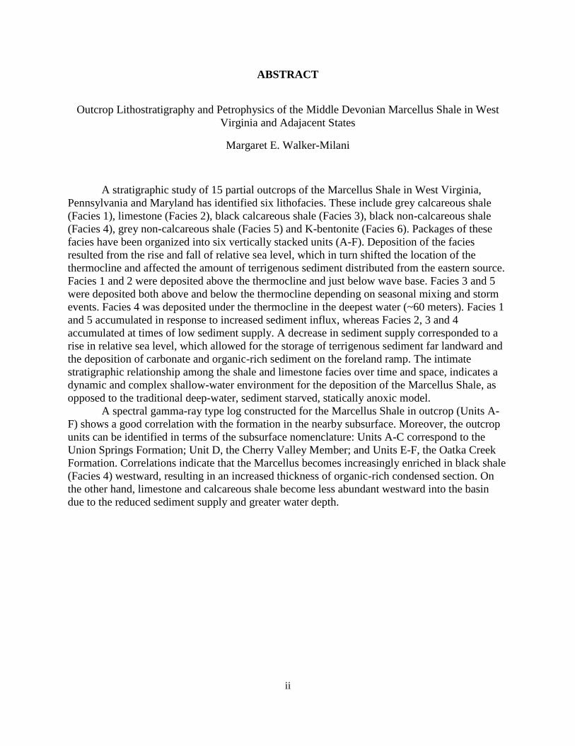
ABSTRACT
Outcrop Lithostratigraphy and Petrophysics of the Middle Devonian Marcellus Shale in West
Virginia and Adajacent States
Margaret E. Walker-Milani
A stratigraphic study of 15 partial outcrops of the Marcellus Shale in West Virginia,
Pennsylvania and Maryland has identified six lithofacies. These include grey calcareous shale
(Facies 1), limestone (Facies 2), black calcareous shale (Facies 3), black non-calcareous shale
(Facies 4), grey non-calcareous shale (Facies 5) and K-bentonite (Facies 6). Packages of these
facies have been organized into six vertically stacked units (A-F). Deposition of the facies
resulted from the rise and fall of relative sea level, which in turn shifted the location of the
thermocline and affected the amount of terrigenous sediment distributed from the eastern source.
Facies 1 and 2 were deposited above the thermocline and just below wave base. Facies 3 and 5
were deposited both above and below the thermocline depending on seasonal mixing and storm
events. Facies 4 was deposited under the thermocline in the deepest water (~60 meters). Facies 1
and 5 accumulated in response to increased sediment influx, whereas Facies 2, 3 and 4
accumulated at times of low sediment supply. A decrease in sediment supply corresponded to a
rise in relative sea level, which allowed for the storage of terrigenous sediment far landward and
the deposition of carbonate and organic-rich sediment on the foreland ramp. The intimate
stratigraphic relationship among the shale and limestone facies over time and space, indicates a
dynamic and complex shallow-water environment for the deposition of the Marcellus Shale, as
opposed to the traditional deep-water, sediment starved, statically anoxic model.
A spectral gamma-ray type log constructed for the Marcellus Shale in outcrop (Units A-
F) shows a good correlation with the formation in the nearby subsurface. Moreover, the outcrop
units can be identified in terms of the subsurface nomenclature: Units A-C correspond to the
Union Springs Formation; Unit D, the Cherry Valley Member; and Units E-F, the Oatka Creek
Formation. Correlations indicate that the Marcellus becomes increasingly enriched in black shale
(Facies 4) westward, resulting in an increased thickness of organic-rich condensed section. On
the other hand, limestone and calcareous shale become less abundant westward into the basin
due to the reduced sediment supply and greater water depth.
iii
TABLE OF CONTENTS
Page
ACKNOWLEDGMENTS ……………………………………………………………. v
LIST OF FIGURES…………………………………………………………………… vi
LIST OF TABLES……………………………………………………………………. ix
INTRODUCTION…………………………………………………………………….. 1
Purpose………………………………………………………………………… 2
Study Area ……………………………………………………………………. 2
Methods……………………………………………………………………….. 5
GEOLOGIC SETTING……………………………………………………………… 10
Regional Overview……………………………………………………………. 10
Stratigraphy……………………………………………………………………. 14
PREVIOUS STUDIES OF BLACK SHALES………………………………………. 18
FACIES ANALYSIS………………………………………………………………….. 21
Facies Descriptions…………………………………………………………….. 25
Facies Interpretations…………………………………………………………. 39
STRATIGRAPHIC PATTERNS……………………………………………………… 45
GAMMA-RAY CORRELATIONS…………………………………………………… 64
CONCLUSIONS………………………………………………………………………. 74
REFERENCES………………………………………………………………………… 77
APPENDIX-OUTCROP DESCRIPTIONS………………………………………….. 83
Burlington, WV……………………………………………………………….... 84
Springfield, WV………………………………………………………………… 88
Greenspring, WV……………………………………………………………….. 90
Petersburg North, WV………………………………………………………….. 92
iv
Tyrone, PA…………………………………………………………………….. 95
Whip Gap, WV………………………………………………………………… 97
Bedford, PA ………………………………………………………………….. 99
Hiser, WV……………………………………………………………………… 102
South Branch of the Potomac, WV ………………………………………….. 104
Oak Flat, WV………………………………………………………………….. 106
Berkeley Springs, WV………………………………………………………… 109
Frost, WV……………………………………………………………………… 113
McCoole, MD …………………………………………………………………... 116
Tomahawk, WV………………………………………………………………... 118
Petersburg West, WV………………………………………………………….. 120
v
ACKNOWLEDGMENTS
First and foremost, I would like to express my gratitude to my advisor, Dr. Richard
Smosna for his superior guidance, dedication and enthusiasm. Thank you for your humor and
constructive criticism, as well as your faith in me to tackle this awesome project. I would also
like to thank my committee members Dr. Tim Carr, Dr. Kathy Bruner, and Dr. John Renton for
their contributions to this project.
This project would not have been possible without funding from the URS Corporation
and the Department of Energy. As well as additional funds provided by Enerplus Corporation
through Dr. Carr and Gus Gustason. X-ray diffraction and thermogravimetric analyses were
performed by Dr. Mohindar Seehrah, Vivek Singh, and Mohita Yalamanchi. Subsurface well log
data was provided by Marathon Oil Corporation.
Special thanks to Katharine Lee Avary and Dr. Jaime Toro for their time and helpful
advice on this project. I would also like to recognize and thank my amazing friends and fellow
graduate students for their support, camaraderie, and entertainment.
I am ever so grateful to my mom and dad for being my biggest cheerleaders, your support
and love is paramount.
Last, but certainly not least, I would like to thank my field partner Kyle Littlefield. Thank
you for your patience, kindness, and hard work. I could not have done this without you.
vi
LIST OF FIGURES
FIGURE PAGE
1. Map of study area with outcrop and well locations……………………………………… 3
2. Stratification and parting scheme used for description of shale lithofacies…………….... 5
3. Descriptive terms for lamina continuity, shape, and geometry………………………….. 6
4. Laminae and bed thickness scheme………………………………………………………. 7
5. An example of a Sedlog® outcrop stratigraphic column for the Marcellus Shale
at Burlington, WV………………………………………………………………………….... 8
6. Paleogeography of Old Red Sandstone continent (Larussia) during Devonian time……. 10
7. Middle Devonian paleogeographic reconstruction (385 Ma) …………………………... 11
8. Regional facies model for the Acadian clastic wedge in the Appalachian Basin ………. 13
9. Appalachian Basin regional stratigraphy………………………………………………… 15
10. Marcellus stratigraphy in New York……………………………………………………. 16
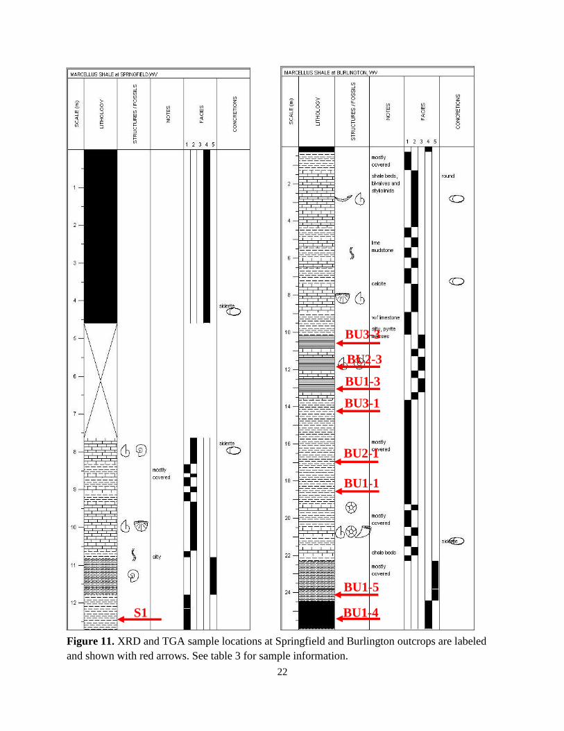
11. XRD and TGA sample locations at Springfield and Burlington outcrops……………… 22
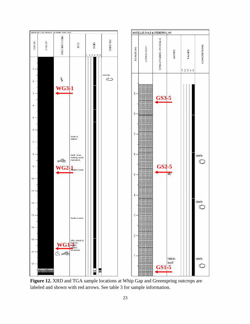
12. XRD and TGA sample locations at Whip Gap and Greenspring outcrop……………… 23
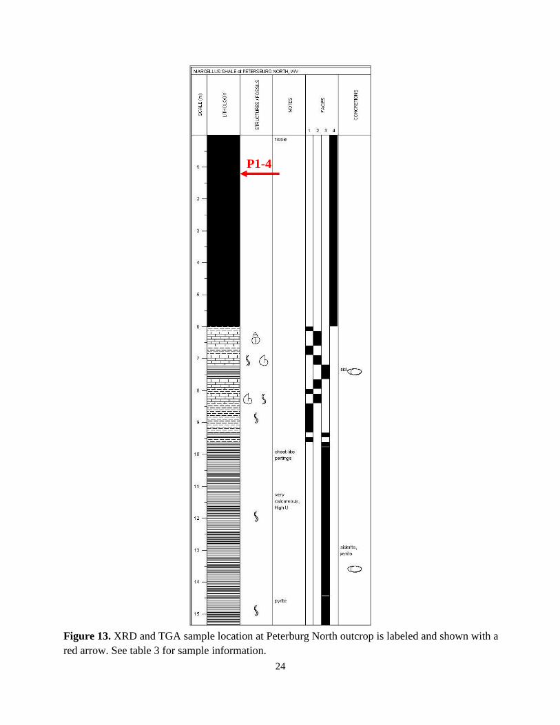
13. XRD and TGA sample location at Petersburg North outcrop………………………....... 24
14. Outcrop photographs of Facies 1, grey calcareous shale………………………………. 27
15. Outcrop photographs of Facies 2, limestone………………………………………….. 29
vii
16. Outcrop photographs of Facies 3, black calcareous shale……………………………… 31
17. Outcrop photographs of Facies 4, black non-calcareous shale…………………………. 34
18. Outcrop photographs of Facies 5, grey non-calcareous shale………………………….. 36
19. Outcrop photographs of Facies 6, Tioga K-bentonite………………………………….. 38
20. Generalized Marcellus Shale facies model depicting periods of low
clastic sediment influx……………………………………………………………………… 39
21. Generalized Marcellus Shale facies model depicting periods of increased
clastic influx........................................................................................................................... 40
22. TGA total organic carbon analysis plotted against clay content from XRD analysis….. 43
23. Graph illustrating the average quartz percentage for Facies 1, 3, 4 and 5……………... 43
24. Composite stratigraphic column and type log for Marcellus Shale in West Virginia….. 48
25. Burlington, WV stratigraphic column and spectral gamma-ray curve………………… 49
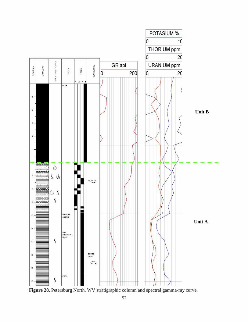
26. Springfield, WV stratigraphic column and spectral gamma-ray curve…………………. 50
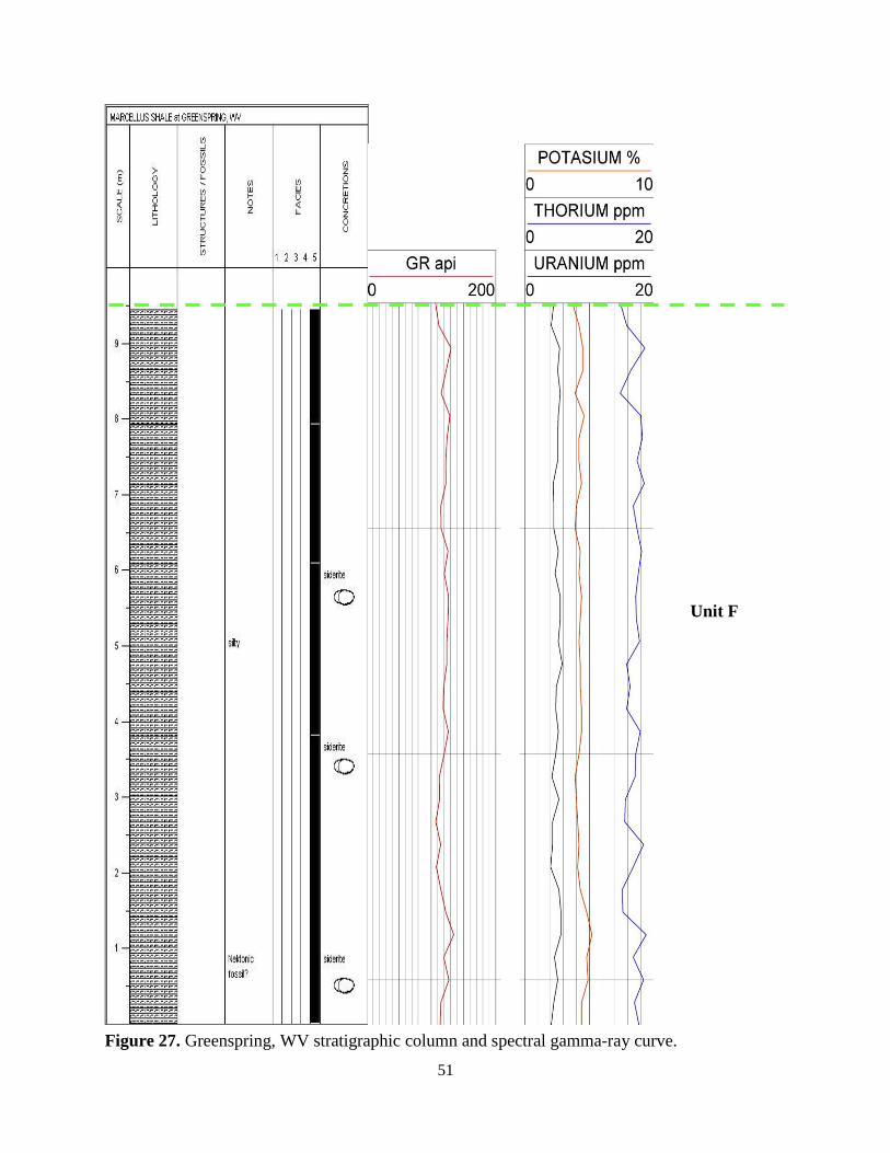
27. Greenspring, WV stratigraphic column and spectral gamma-ray curve………………... 51
28. Petersburg North, WV stratigraphic column and spectral gamma-ray curve…………… 52
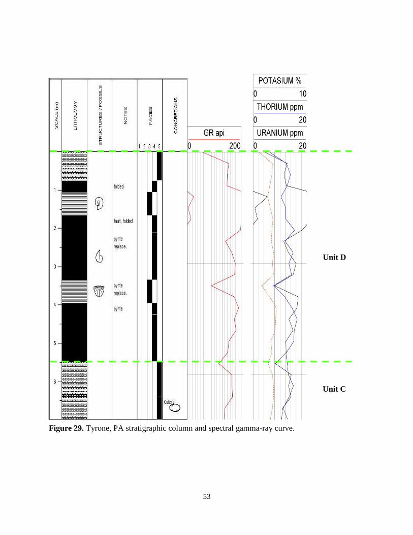
29. Tyrone, PA stratigraphic column and spectral gamma-ray curve………………………. 53
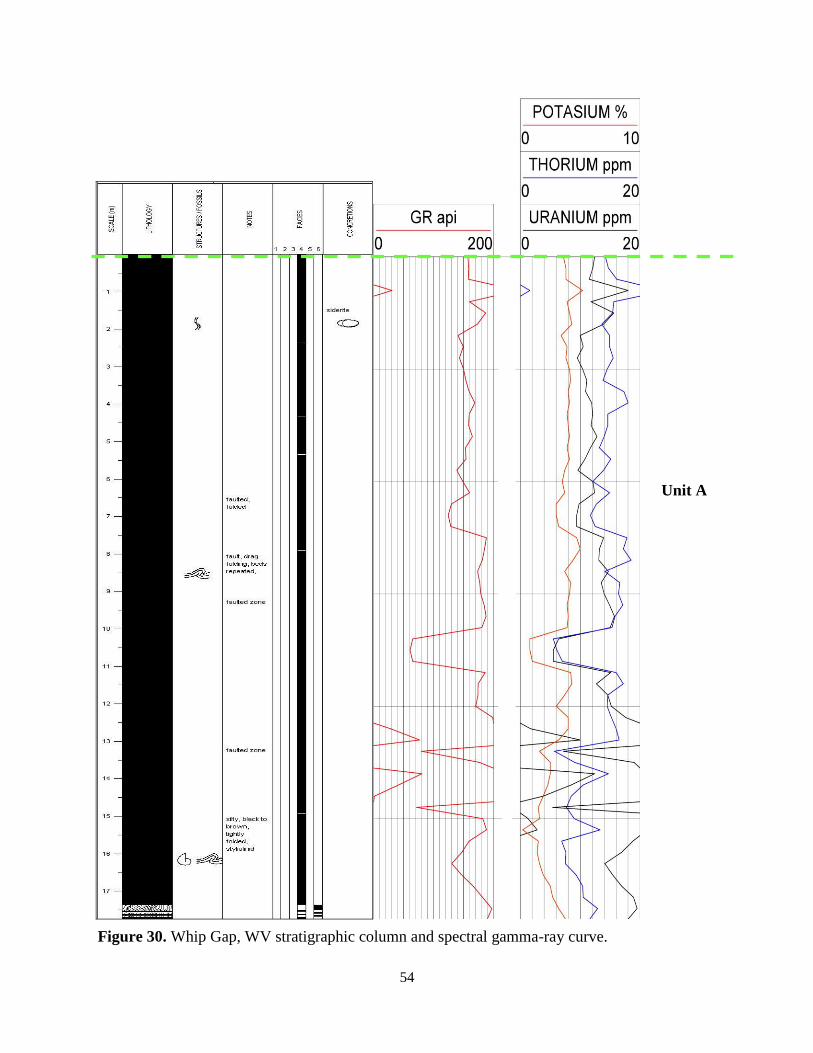
30. Whip Gap, WV stratigraphic column and spectral gamma-ray curve………………….. 54
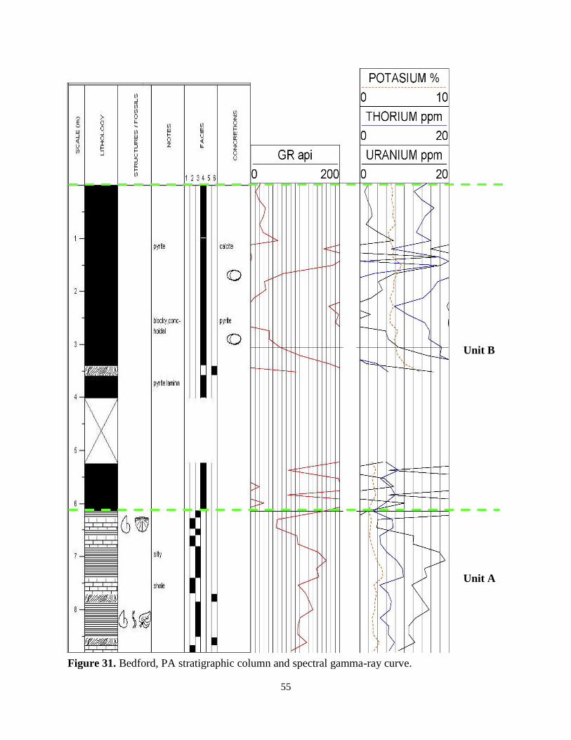
31. Bedford, PA stratigraphic column and spectral gamma-ray curve……………………… 55
viii
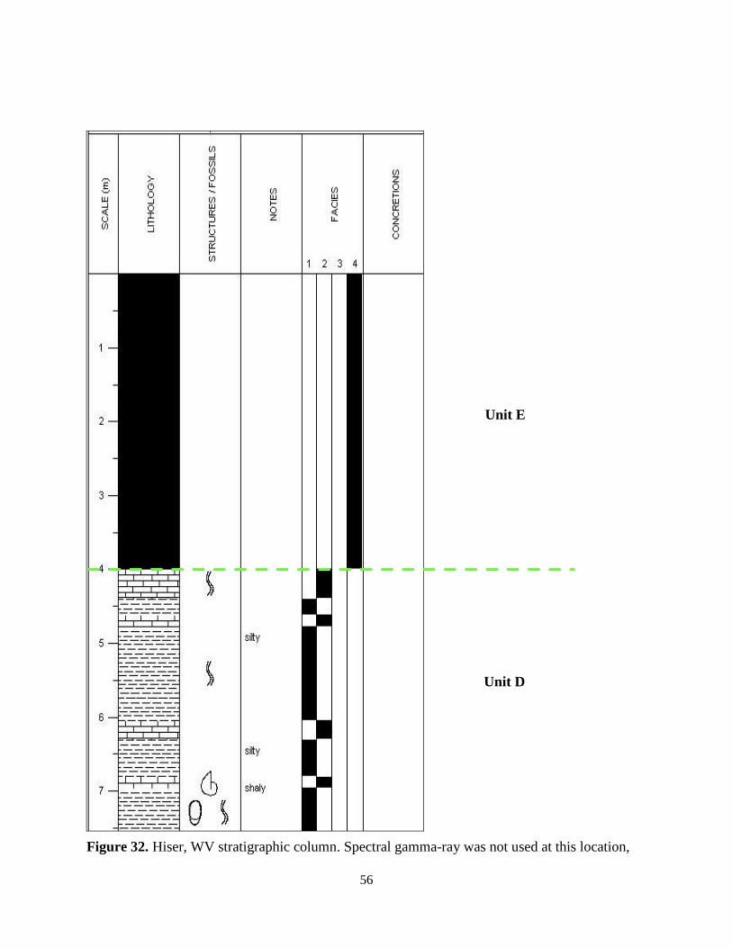
32. Hiser, WV stratigraphic column………………………………………………………… 56
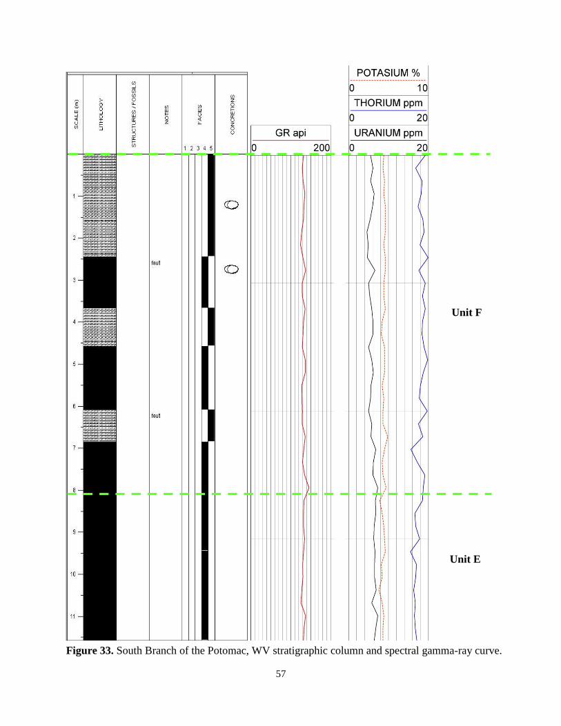
33. South Branch, WV stratigraphic column and spectral gamma-ray curve………………. 57
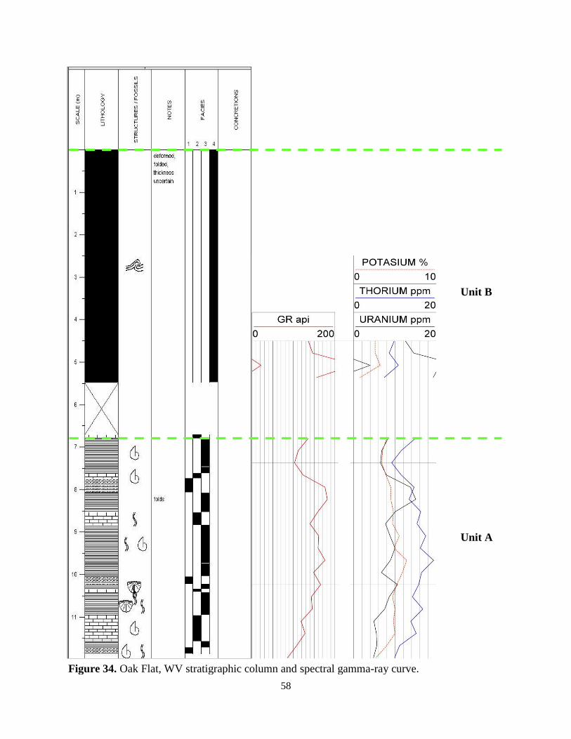
34. Oak Flat, WV stratigraphic column and spectral gamma-ray curve…………………… 58
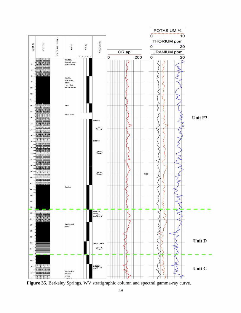
35. Berkeley Springs, WV stratigraphic column and spectral gamma-ray curve…………. 59
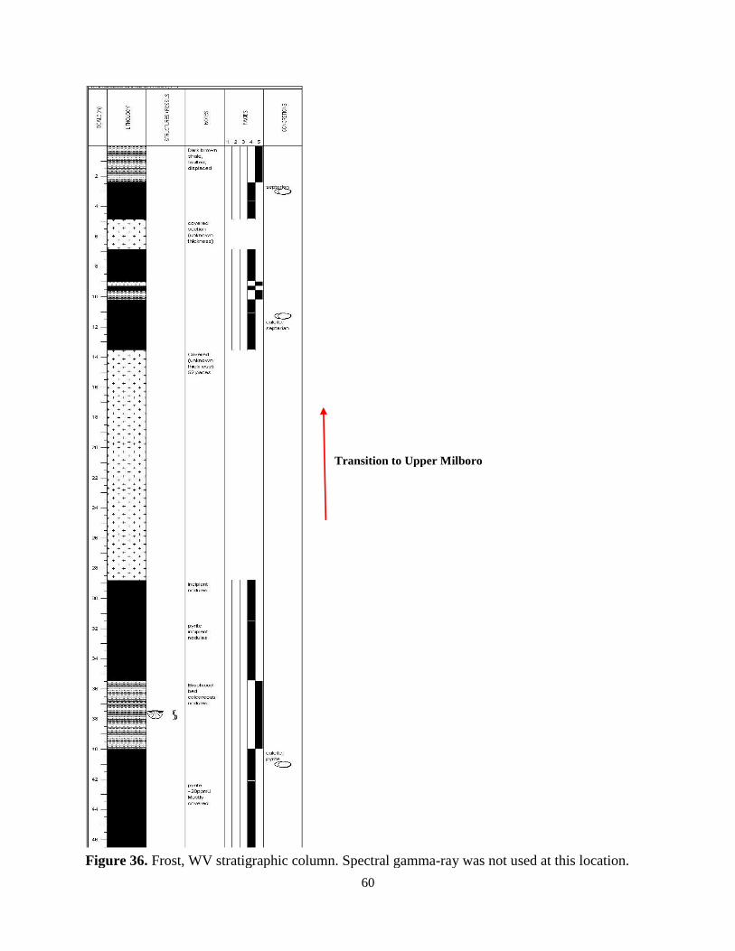
36. Frost, WV stratigraphic column……………………………………………………….. 60
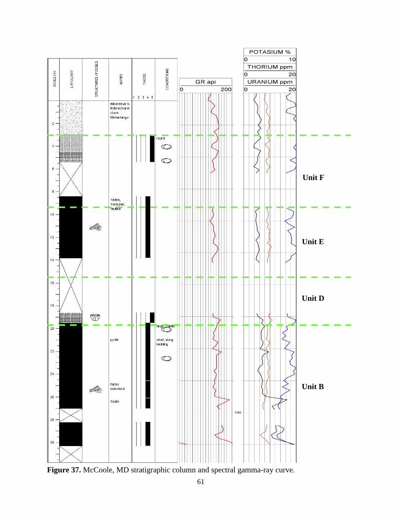
37. McCoole, MD stratigraphic column and spectral gamma-ray curve………………….. 61
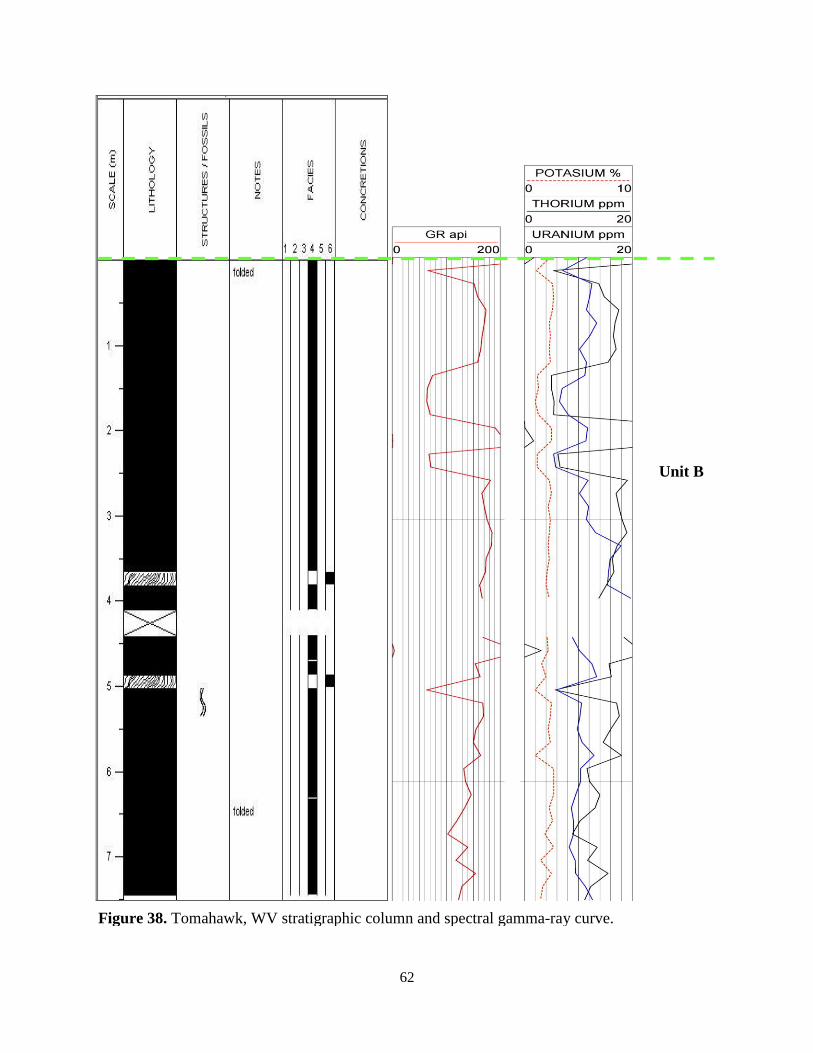
38. Tomahawk, WV stratigraphic column and spectral gamma-ray curve………………… 62
39. Petersburg West, WV stratigraphic column and spectral gamma-ray curve………….. 63
40. Outcrop type log (units A-F) correlated with three subsurface wells………………. 72
41. Units (A-F) of the Marcellus Shale type log are correlated with two adjacent
wells in Grant County, West Virginia ……………………………………………………. 73
ix
LIST OF TABLES
TABLE PAGE
1. Names and locations (latitude and longitude) of studied Marcellus Shale outcrops……... 4
2. Luster and color of rock when powdered based on field characteristics of lithofacies….. 6
3. X-ray diffraction and TOC data (weight percent)………………………………………. 21
4. Sedimentary characteristics of Facies 1, grey calcareous shale………………………… 26
5. Sedimentary characteristics of Facies 2, limestone……………………………………… 28
6. Sedimentary characteristics of Facies 3, black calcareous shale……………………….. 30
7. Sedimentary characteristics of Facies 4, black non-calcareous shale…………………… 33
8. Sedimentary characteristics of Facies 5, grey non-calcareous shale……………………. 35
9. Sedimentary characteristics of Facies 6, K-bentonite…………………………………... 37
1
INTRODUCTION
The Marcellus Shale of the Appalachian Basin has traditionally been regarded as the
petroleum source rock for conventional Upper Devonian and Lower Mississippian reservoirs.
Although the Marcellus has a history of gas production dating back to 1821, the recent
rejuvenation of Marcellus exploration began in 2004 when Range Resources introduced two
crucial drilling and treatment technologies: horizontal wells and slickwater fracture stimulation.
Their initial reports announced a remarkable success in Pennsylvania, kicking off a new
unconventional shale gas play in the Appalachian Basin. The core area – where the formation
exceeds 50 ft. thick, is thermally mature, and is generally understood to have the best gas
potential—includes Pennsylvania, West Virginia and New York, a staggering 50,000 sq. mi.
To date, most sedimentary studies have focused on the subsurface near the Marcellus
core area (Roen, 1984; Boswell, 1996; Harper, 1999; Milici and Swezey, 2006; Ettensohn, 2008;
Wrightstone, 2009; Boyce, 2010) and on outcrops in New York and Pennsylvania (Engelder
2008; Lash, 2009). Very few detailed investigations have addressed the outcrops of West
Virginia though preliminary work suggests that the Marcellus shale in West Virginia has a
significantly different character than that to the north and west (Woodward, 1943; Dennison,
1960).
The primary goal of this thesis is to describe and interpret the sedimentological and
stratigraphic nature of the Marcellus Shale in the outcrop belt of West Virginia and adjacent
states of Pennsylvania and Maryland. A secondary goal is to create a type log from outcrop
spectral gamma-ray data and correlate it to nearby well logs, so that my interpretations may be
extended into the subsurface of the Appalachian Basin.
2
Purpose
The purpose of this thesis is to better characterize the Marcellus Shale in terms of its
sedimentological, stratigraphic and petrophysical properties within the outcrop belt of West
Virginia and adjacent areas in Pennsylvanian and Maryland. Another purpose is to identify and
describe the facies within the Marcellus and interpret them in terms of water depth, water
chemistry, terrigenous input, organic content, and their temporal and spatial distribution. The
spectral gamma-ray scintillometer was used to create an outcrop type log. The outcrop type log is
used to correlate gamma-ray profiles to nearby well logs. The intent is to add further insight
concerning the factors that control black shale deposition.
Study Area
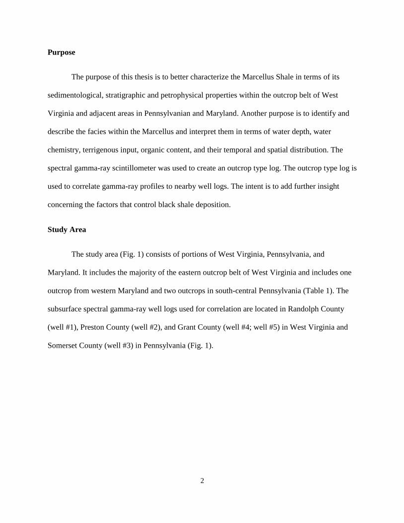
The study area (Fig. 1) consists of portions of West Virginia, Pennsylvania, and
Maryland. It includes the majority of the eastern outcrop belt of West Virginia and includes one
outcrop from western Maryland and two outcrops in south-central Pennsylvania (Table 1). The
subsurface spectral gamma-ray well logs used for correlation are located in Randolph County
(well #1), Preston County (well #2), and Grant County (well #4; well #5) in West Virginia and
Somerset County (well #3) in Pennsylvania (Fig. 1).
3
Figure 1. Map of study area with outcrop and well locations. Well data was donated by
petroleum companies, locations are approximate due to constraints on proprietary data.
5
4
1
2
3
4 5
6 7
8 9
10 11
12
13
14
15
1
2
3
4
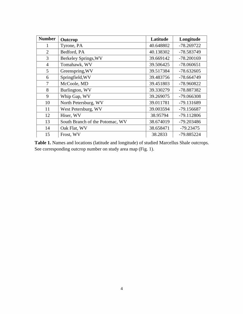
Number Outcrop Latitude Longitude
1 Tyrone, PA 40.648802 -78.269722
2 Bedford, PA 40.138302 -78.583749
3 Berkeley Springs,WV 39.669142 -78.200169
4 Tomahawk, WV 39.506425 -78.060651
5 Greenspring,WV 39.517384 -78.632605
6 Springfield,WV 39.483756 -78.664749
7 McCoole, MD 39.451803 -78.960822
8 Burlington, WV 39.330279 -78.887382
9 Whip Gap, WV 39.269075 -79.066308
10 North Petersburg, WV 39.011781 -79.131689
11 West Petersburg, WV 39.003594 -79.156687
12 Hiser, WV 38.95794 -79.112806
13 South Branch of the Potomac, WV 38.674019 -79.203486
14 Oak Flat, WV 38.658471 -79.23475
15 Frost, WV 38.2833 -79.885224
Table 1. Names and locations (latitude and longitude) of studied Marcellus Shale outcrops.
See corresponding outcrop number on study area map (Fig. 1).
5
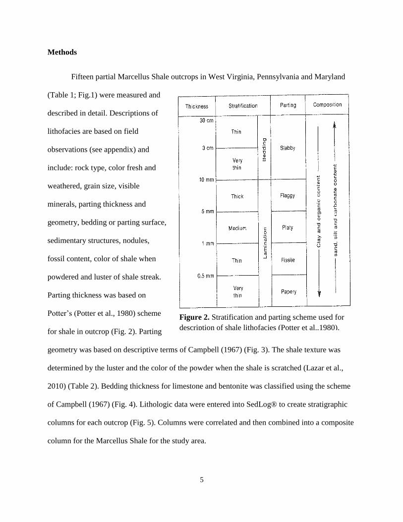
Methods
Fifteen partial Marcellus Shale outcrops in West Virginia, Pennsylvania and Maryland
(Table 1; Fig.1) were measured and
described in detail. Descriptions of
lithofacies are based on field
observations (see appendix) and
include: rock type, color fresh and
weathered, grain size, visible
minerals, parting thickness and
geometry, bedding or parting surface,
sedimentary structures, nodules,
fossil content, color of shale when
powdered and luster of shale streak.
Parting thickness was based on
Potter’s (Potter et al., 1980) scheme
for shale in outcrop (Fig. 2). Parting
geometry was based on descriptive terms of Campbell (1967) (Fig. 3). The shale texture was
determined by the luster and the color of the powder when the shale is scratched (Lazar et al.,
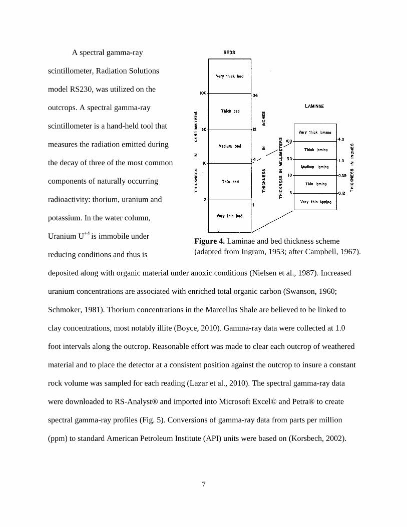
2010) (Table 2). Bedding thickness for limestone and bentonite was classified using the scheme
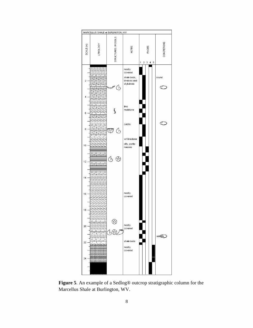
of Campbell (1967) (Fig. 4). Lithologic data were entered into SedLog® to create stratigraphic
columns for each outcrop (Fig. 5). Columns were correlated and then combined into a composite
column for the Marcellus Shale for the study area.
Figure 2. Stratification and parting scheme used for
description of shale lithofacies (Potter et al.,1980).
6
Table 2. Luster and color of rock when powdered based on field characteristics of
lithofacies modified after (Lazar et al., 2010).
Figure 3. Descriptive terms for lamina continuity, shape and geometry (Lazar et
al., 2010; modified after Campbell, 1967).
7
A spectral gamma-ray
scintillometer, Radiation Solutions
model RS230, was utilized on the
outcrops. A spectral gamma-ray
scintillometer is a hand-held tool that
measures the radiation emitted during
the decay of three of the most common
components of naturally occurring
radioactivity: thorium, uranium and
potassium. In the water column,
Uranium U+4
is immobile under
reducing conditions and thus is
deposited along with organic material under anoxic conditions (Nielsen et al., 1987). Increased
uranium concentrations are associated with enriched total organic carbon (Swanson, 1960;
Schmoker, 1981). Thorium concentrations in the Marcellus Shale are believed to be linked to
clay concentrations, most notably illite (Boyce, 2010). Gamma-ray data were collected at 1.0
foot intervals along the outcrop. Reasonable effort was made to clear each outcrop of weathered
material and to place the detector at a consistent position against the outcrop to insure a constant
rock volume was sampled for each reading (Lazar et al., 2010). The spectral gamma-ray data
were downloaded to RS-Analyst® and imported into Microsoft Excel© and Petra® to create
spectral gamma-ray profiles (Fig. 5). Conversions of gamma-ray data from parts per million
(ppm) to standard American Petroleum Institute (API) units were based on (Korsbech, 2002).
Figure 4. Laminae and bed thickness scheme
(adapted from Ingram, 1953; after Campbell, 1967).
8
Figure 5. An example of a Sedlog® outcrop stratigraphic column for the
Marcellus Shale at Burlington, WV.
9
A gamma-ray type log was compiled from spectral gamma-ray outcrop profiles and used to
correlate the Marcellus Shale into the subsurface.
Representative rock samples from several outcrops were collected and analyzed by X-ray
diffraction (XRD) and thermogravimetric analyses (TGA) to determine the bulk shale
mineralogy and total organic carbon (TOC) of each sample.
Field descriptions, stratigraphic columns, XRD and TOC analysis, and spectral gamma-
ray outcrop data provided the basis for identification of lithofacies and interpretation of
depositional environments (Fig. 11-13).
10
GEOLOGIC SETTING
Regional Overview
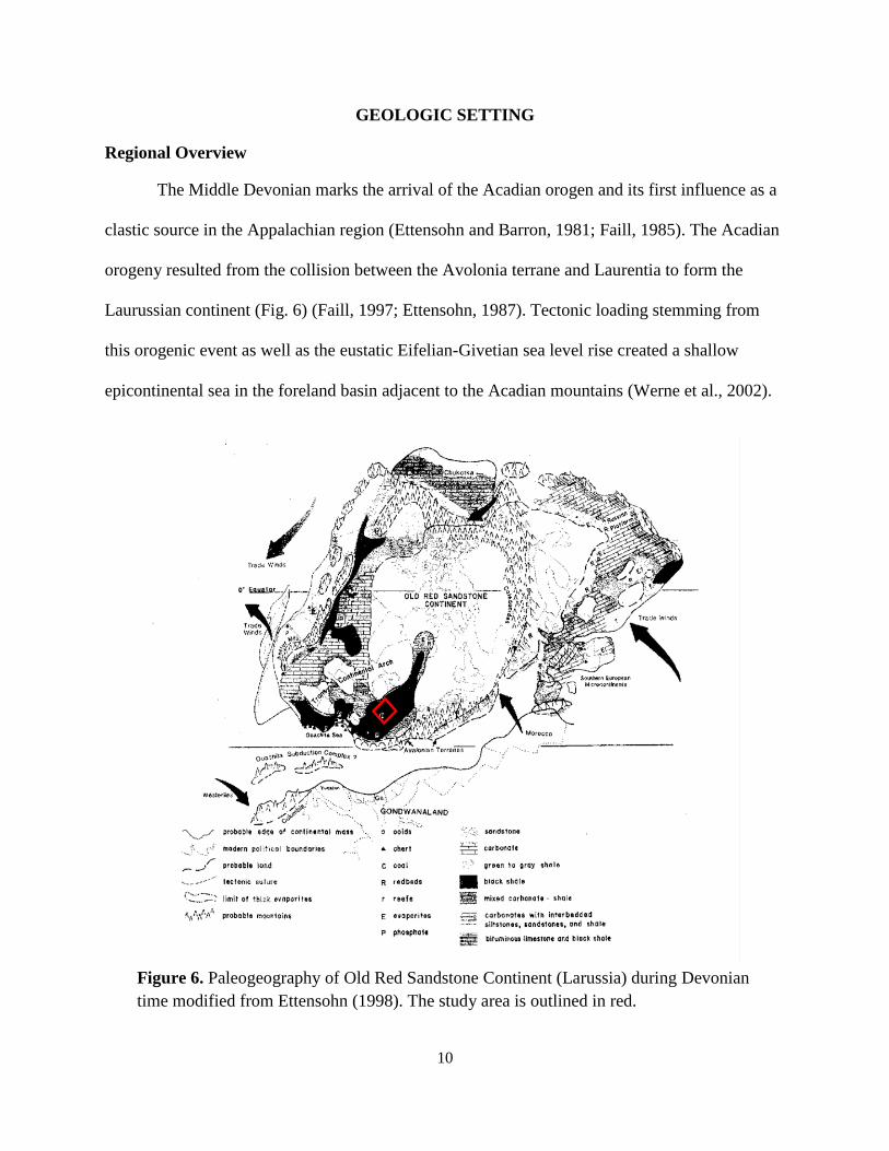
The Middle Devonian marks the arrival of the Acadian orogen and its first influence as a
clastic source in the Appalachian region (Ettensohn and Barron, 1981; Faill, 1985). The Acadian
orogeny resulted from the collision between the Avolonia terrane and Laurentia to form the
Laurussian continent (Fig. 6) (Faill, 1997; Ettensohn, 1987). Tectonic loading stemming from
this orogenic event as well as the eustatic Eifelian-Givetian sea level rise created a shallow
epicontinental sea in the foreland basin adjacent to the Acadian mountains (Werne et al., 2002).
Figure 6. Paleogeography of Old Red Sandstone Continent (Larussia) during Devonian
time modified from Ettensohn (1998). The study area is outlined in red.
11
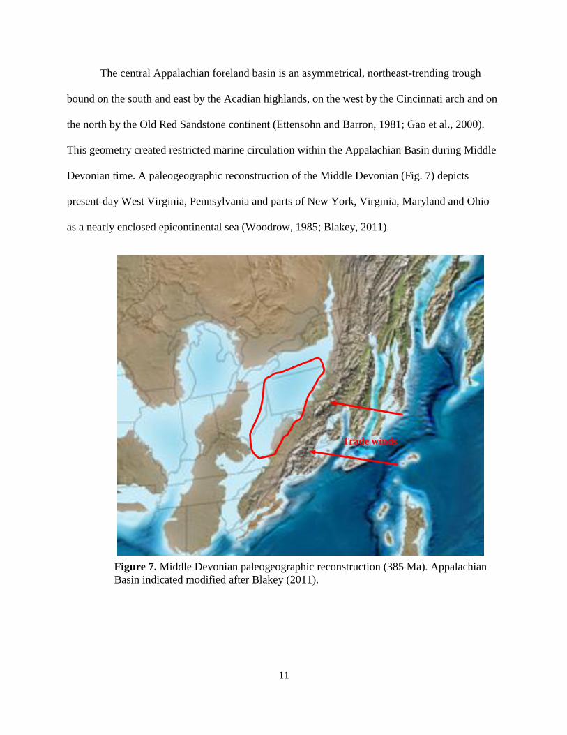
The central Appalachian foreland basin is an asymmetrical, northeast-trending trough
bound on the south and east by the Acadian highlands, on the west by the Cincinnati arch and on
the north by the Old Red Sandstone continent (Ettensohn and Barron, 1981; Gao et al., 2000).
This geometry created restricted marine circulation within the Appalachian Basin during Middle
Devonian time. A paleogeographic reconstruction of the Middle Devonian (Fig. 7) depicts
present-day West Virginia, Pennsylvania and parts of New York, Virginia, Maryland and Ohio
as a nearly enclosed epicontinental sea (Woodrow, 1985; Blakey, 2011).
Figure 7. Middle Devonian paleogeographic reconstruction (385 Ma). Appalachian
Basin indicated modified after Blakey (2011).
Trade winds
12
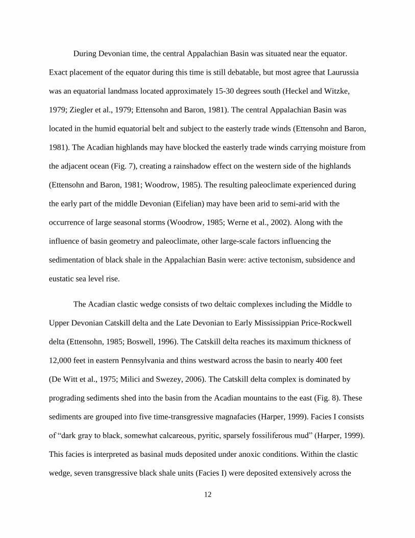
During Devonian time, the central Appalachian Basin was situated near the equator.
Exact placement of the equator during this time is still debatable, but most agree that Laurussia
was an equatorial landmass located approximately 15-30 degrees south (Heckel and Witzke,
1979; Ziegler et al., 1979; Ettensohn and Baron, 1981). The central Appalachian Basin was
located in the humid equatorial belt and subject to the easterly trade winds (Ettensohn and Baron,
1981). The Acadian highlands may have blocked the easterly trade winds carrying moisture from
the adjacent ocean (Fig. 7), creating a rainshadow effect on the western side of the highlands
(Ettensohn and Baron, 1981; Woodrow, 1985). The resulting paleoclimate experienced during
the early part of the middle Devonian (Eifelian) may have been arid to semi-arid with the
occurrence of large seasonal storms (Woodrow, 1985; Werne et al., 2002). Along with the
influence of basin geometry and paleoclimate, other large-scale factors influencing the
sedimentation of black shale in the Appalachian Basin were: active tectonism, subsidence and
eustatic sea level rise.
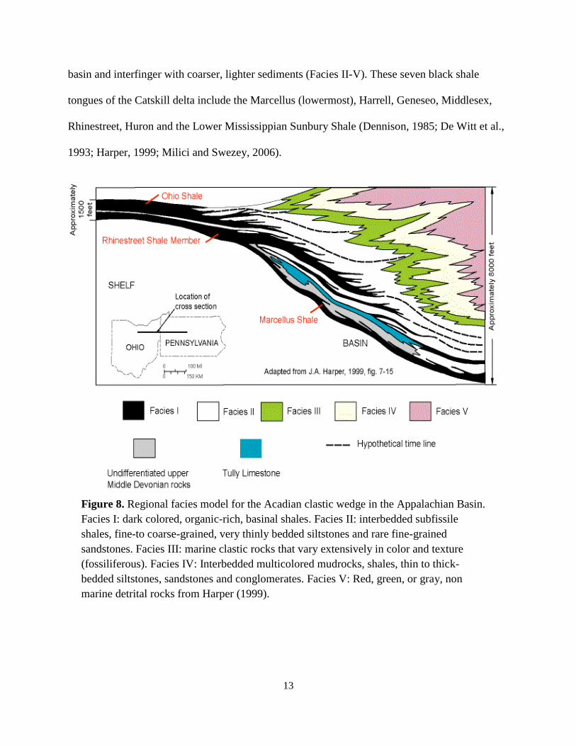
The Acadian clastic wedge consists of two deltaic complexes including the Middle to
Upper Devonian Catskill delta and the Late Devonian to Early Mississippian Price-Rockwell
delta (Ettensohn, 1985; Boswell, 1996). The Catskill delta reaches its maximum thickness of
12,000 feet in eastern Pennsylvania and thins westward across the basin to nearly 400 feet
(De Witt et al., 1975; Milici and Swezey, 2006). The Catskill delta complex is dominated by
prograding sediments shed into the basin from the Acadian mountains to the east (Fig. 8). These
sediments are grouped into five time-transgressive magnafacies (Harper, 1999). Facies I consists
of ―dark gray to black, somewhat calcareous, pyritic, sparsely fossiliferous mud‖ (Harper, 1999).
This facies is interpreted as basinal muds deposited under anoxic conditions. Within the clastic
wedge, seven transgressive black shale units (Facies I) were deposited extensively across the
13
basin and interfinger with coarser, lighter sediments (Facies II-V). These seven black shale
tongues of the Catskill delta include the Marcellus (lowermost), Harrell, Geneseo, Middlesex,
Rhinestreet, Huron and the Lower Mississippian Sunbury Shale (Dennison, 1985; De Witt et al.,
1993; Harper, 1999; Milici and Swezey, 2006).
Figure 8. Regional facies model for the Acadian clastic wedge in the Appalachian Basin.
Facies I: dark colored, organic-rich, basinal shales. Facies II: interbedded subfissile
shales, fine-to coarse-grained, very thinly bedded siltstones and rare fine-grained
sandstones. Facies III: marine clastic rocks that vary extensively in color and texture
(fossiliferous). Facies IV: Interbedded multicolored mudrocks, shales, thin to thick-
bedded siltstones, sandstones and conglomerates. Facies V: Red, green, or gray, non
marine detrital rocks from Harper (1999).
14
Stratigraphy
The Hamilton Group of the Appalachian Basin is comprised of the older
Marcellus Shale and the younger Mahantango Formation (Willard, 1935; Woodward, 1943). The
Middle Devonian Hamilton Group was deposited in the Appalachian Basin in what is now
Pennsylvania, West Virginia, and parts of Maryland, New York, Virginia, and Ohio (Fig. 7). The
Hamilton Group, deposited roughly 385 Ma, belongs to the Eifelian and Givetian stages of the
Middle Devonian.
The Hamilton Group increases in thickness and complexity from southwest to the
northeast (Harper, 2008). It ranges in thickness from approximately 50 feet in western West
Virginia to roughly 1700 feet in southwestern Pennsylvania (Woodward, 1943). Throughout the
Appalachian Basin the Marcellus Shale ranges from thickness of zero feet in Ohio to roughly
800 feet in eastern reaches of the basin (Harper, 1999). Woodward (1943) suggests a maximum
thickness of roughly 250-300 feet in the eastern panhandle of West Virginia. However, these
thickness values are overestimated due to faulting and deformation. Regional mapping suggests a
maximum thickness of ~200 feet in West Virginia (Wrightstone, 2009; VanMeter, 2011,
personal communication).
15
As a whole, the Marcellus Shale is frequently described as homogenous carbonaceous
black shale, containing locally abundant pyrite, carbonate concretions and very few fossils
(Ettensohn and Baron, 1981; Harper, 1999). The Marcellus Shale of West Virginia has
previously been described as black fissile carbonaceous shale that weathers grey. Several beds of
calcareous shale and black limestone, and one or more zones of concretions (varying in
composition, abundance and character) have also been recognized (Woodward, 1943; Dennison,
1960). The Marcellus shale has been reported to maintain this same character from east-central
Pennsylvania to as far south as Bluefield, Virginia (Woodward, 1943).
Figure 9. Appalachian Basin regional stratigraphy modified from Milici and Swezey (2006).
16
The Marcellus Shale of western New York has been elevated to subgroup status and
contains two distinct formations, the Union Springs and the Oatka Creek (Ver Straeten, 2007).
The Union Springs is a highly organic, calcareous mudstone containing skeletal lags (Sageman et
al., 2003). The overlying Oatka Creek Formation consists of several members including the
Cherry Valley, Hurley and Berne members (Fig. 10) (Engelder and Lash, 2011). Directly
overlying the Oatka Creek Formation in western New York are the dark shales and fossiliferous
limestone beds of the Hurley Member (Engelder and Lash, 2011). The Cherry Valley Member of
western New York is a bedded to nodular limestone that contains thin to thick black shale
interbeds (Ver Straeten, 2007). The Cherry Valley Limestone, also called the Purcell Member, is
recognized as calcareous shale in southern Pennsylvania and nodular limestone and shale in
West Virginia and Virginia (Ver Straeten, 2007). The overlying Berne Member is a dark grey to
black shale (Engelder and Lash, 2011).
Figure 10. Marcellus stratigraphy in New York modified from Engelder and Lash (2011).
17
Throughout most of the Appalachian Basin the Marcellus Shale lies conformably upon
Lower Devonian strata including the Onondaga Limestone, Huntersville Chert and the Needmore
Shale. These three facies interfinger laterally with one another and represent a western carbonate
facies, a central basin siliceous facies, and an eastern clastic facies, respectively (Dennison,
1960; Basan et al., 1980; Sherrard and Heald, 1984).
The Tioga K-bentonite was deposited as seven distinct units across the basin during
Onondaga through Marcellus time. The Tioga ash zones consist of micaceous tuff layers (middle
coarse zone) and yellow to grey-brown laminated micaceous shale, and are thought to have
originated from a volcano near Fredericksburg, Virginia (Dennison and Textoris, 1977; Harper,
1999; Ver Straeten, 2004).
Nearing the end of the Middle Devonian, coarse clastic sediments of the Mahantango
Formation were shed into the basin. The Mahantango Formation, a large deltaic wedge, lies
conformably above the Marcellus throughout the basin and to the east it consists of grey to dark
grey-black shale, siltstone, limestone and fine-grained sandstone (Ettensohn and Baron, 1981;
Ver Straeten, 2007; Harper, 2008).
18
PREVIOUS STUDIES OF BLACK SHALE
Two fundamental schools of thought attempt to explain the organic richness observed in
black shale. The preservation school (Demaison and Moore, 1980; Ettensohn, 1981) requires the
presence of a permanently stratified water column (pycnocline). Under these conditions anoxic
bottom waters can persist and allow for enhanced preservation of organic material in basin
sediments. On the other hand, the production school (Pedersen and Calvert, 1990) argues that
high concentrations of organic matter in black shale are a result of enhanced primary
productivity in the surface water. Under enhanced productivity, the presence of anoxia is
explained as a result of organic enrichment of bottom sediments rather than the cause.
Most depositional models for black shale combine both increased productivity and
preservation of organic matter. These models for black shale deposition embrace multiple factors
to explain productivity and preservation. They consider the effects of sediment rate, local
tectonism, relative sea level, paleoclimate and biogeochemical cycling in the creation of black
shale (Ettensohn and Barron, 1981; Werne et al., 2002; Sageman et al., 2003).
Ettensohn’s (1985) depositional model called upon a deep-water environment for the
deposition of black shale. His tectono-stratigraphic model emphasized active tectonism, which
led to rapid subsidence and a deepening of the foreland basin. Oceanic upwelling of nutrient-
rich water resulted in high biologic productivity and subsequent accumulation of organic
material in a deep-water basin below a permanent pycnocline. Sediment starvation due to the
rain shadow effect from the Acadian mountains allowed for the preservation of the organic
matter. The presence of a permanent pycnocline explains the preservation of organic matter, and
implies a deep, stagnant basin for these circumstances to persist. Algeo and Schekler (1998)
19
recognized the possible impact of Middle Devonian land plants on the deposition of black shale.
The large increase in deep-rooted land plants in the Middle Devonian allowed for increased
chemical weathering and nutrient runoff into the sea, as well as decreased erosion. These effects
allowed for nutrients, but not clastic sediments, to enter the Appalachian Basin and create algal
blooms. These factors resulted in the preservation of organic material in the basin (Algeo and
Schekler, 1998).
Schwietering’s (1977, 1981) depositional model favored the shallow to moderately deep
environment for the deposition of black shale. They proposed that black shale was deposited on
the shallow epicontinental sea shelf along the western margin of the Appalachian Basin.
Evidence for the deposition of black muds on a shallow shelf include: the westward thinning of
the Hamilton group onto the paleo-shore of the Cincinnati Arch and the deposition of black shale
as the first transgressive unit on top of an erosional unconformity. Both features indicate a
shallow shelf rather than a deep basinal black shale deposit (Schwietering, 1977; Schwietering
and Erwin, 1981). Sediment starvation of the western margin resulted from the basin center
acting as a sediment trap for the clastic source to the east. This allowed black organic-rich
sediment to accumulate on the shallow shelf. Streams entering the ocean from the stable western
craton carried fresh water into the more saline sea water creating a stratified water column
(halocline) on the shallow epicontinental sea shelf (Schweitering, 1977; Smith and Leone, 2010).
An alternative model relating to the deposition of the Marcellus Shale in New York,
envisions a shallow-water basin subjected to occasional storm activity that allowed for more
oxygenated surface waters to mix with anoxic bottom waters (Sageman et al., 2003). Mixing led
to seasonal oxic/anoxic oscillations resulting in a seasonal thermocline rather than a permanent
pycnolcine. Nutrient-rich bottom waters brought to the surface by mixing resulting in high levels
20
of primary productivity in the surface water, thus increasing the potential delivery of organic
matter to the sea floor. The seasonally anoxic basin, coupled with the effects of sediment
starvation and relative sea level rise, resulted in the formation of the Oatka Creek Formation of
the Marcellus Shale (Werne et al., 2002; Sageman et al., 2003).
Whereas many models associate the deposition of organic-rich black shale with the depth
of the basin, facies and fauna changes within the Marcellus Shale may be due to factors
independent of depth. These include changes in circulation, nutrient supply of the water column,
sedimentation rates and substrate stability (McCollum, 1988). Some authors speculated that
water depth was not at all a critical factor in the deposition of black shale as long as there were
high primary productivity and anoxic bottom water (Provo, 1978; McCollum, 1988).
21
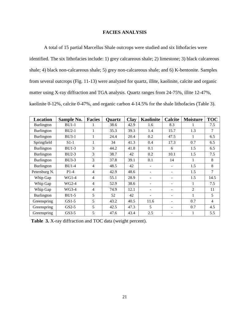
FACIES ANALYSIS
A total of 15 partial Marcellus Shale outcrops were studied and six lithofacies were
identified. The six lithofacies include: 1) grey calcareous shale; 2) limestone; 3) black calcareous
shale; 4) black non-calcareous shale; 5) grey non-calcareous shale; and 6) K-bentonite. Samples
from several outcrops (Fig. 11-13) were analyzed for quartz, illite, kaolinite, calcite and organic
matter using X-ray diffraction and TGA analysis. Quartz ranges from 24-75%, illite 12-47%,
kaolinite 0-12%, calcite 0-47%, and organic carbon 4-14.5% for the shale lithofacies (Table 3).
Location Sample No. Facies
No.
Quartz Clay Kaolinite Calcite Moisture TOC Burlington BU1-1 1 38.6 42.9 1.6 8.3 1 7.5
Burlington BU2-1 1 35.3 39.3 1.4 15.7 1.3 7
Burlington BU3-1 1 24.4 20.4 0.2 47.5 1 6.5
Springfield S1-1 1 34 41.3 0.4 17.3 0.7 6.5
Burlington BU1-3 3 44.2 41.8 0.1 6 1.5 6.5
Burlington BU2-3 3 38.7 42 0.2 10.1 1.5 7.5
Burlington BU3-3 3 37.8 39.1 0.1 14 1 8
Burlington BU1-4 4 48.5 42 - - 1.5 8
Petersburg N. P1-4 4 42.9 48.6 - - 1.5 7
Whip Gap WG1-4 4 55.1 28.9 - - 1.5 14.5
Whip Gap WG2-4 4 52.9 38.6 - - 1 7.5
Whip Gap WG3-4 4 74.9 12.1 - - 2 11
Burlington BU1-5 5 52 42 - - 1 5
Greenspring GS1-5 5 43.2 40.5 11.6 - 0.7 4
Greenspring GS2-5 5 42.5 47.3 5 - 0.7 4.5
Greenspring GS3-5 5 47.6 43.4 2.5 - 1 5.5
Table 3. X-ray diffraction and TOC data (weight percent).
22
Figure 11. XRD and TGA sample locations at Springfield and Burlington outcrops are labeled
and shown with red arrows. See table 3 for sample information.
BU1-4 S1
BU1-5
BU1-1
BU2-1
BU3-1
BU1-3
BU2-3
BU3-3
23
Figure 12. XRD and TGA sample locations at Whip Gap and Greenspring outcrops are
labeled and shown with red arrows. See table 3 for sample information.
WG1-1
WG2-1
WG3-1
GS1-5
GS2-5
GS3-5
24
P1-4
Figure 13. XRD and TGA sample location at Peterburg North outcrop is labeled and shown with a
red arrow. See table 3 for sample information.
25
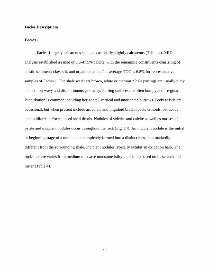
Facies Descriptions
Facies 1
Facies 1 is grey calcareous shale, occasionally slightly calcareous (Table. 4). XRD
analysis established a range of 8.3-47.5% calcite, with the remaining constituents consisting of
clastic sediment; clay, silt, and organic matter. The average TOC is 6.8% for representative
samples of Facies 1. The shale weathers brown, white or maroon. Shale partings are usually platy
and exhibit wavy and discontinuous geometry. Parting surfaces are often bumpy and irregular.
Bioturbation is common including horizontal, vertical and unoriented burrows. Body fossils are
occasional, but when present include articulate and linguloid brachiopods, crinoids, ostracods
and oxidized and/or replaced shell debris. Nodules of siderite and calcite as well as masses of
pyrite and incipient nodules occur throughout the rock (Fig. 14). An incipient nodule is the initial
or beginning stage of a nodule, not completely formed into a distinct mass, but markedly
different from the surrounding shale. Incipient nodules typically exhibit an oxidation halo. The
rocks texture varies from medium to coarse mudstone (silty mudstone) based on its scratch and
luster (Table 4).
26
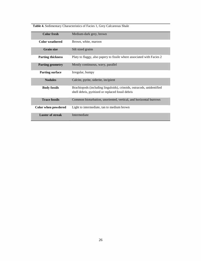
Table 4. Sedimentary Characteristics of Facies 1, Grey Calcareous Shale
Color fresh Medium-dark grey, brown
Color weathered Brown, white, maroon
Grain size Silt sized grains
Parting thickness Platy to flaggy, also papery to fissile where associated with Facies 2
Parting geometry Mostly continuous, wavy, parallel
Parting surface Irregular, bumpy
Nodules Calcite, pyrite, siderite, incipient
Body fossils Brachiopods (including linguloids), crinoids, ostracods, unidentified
shell debris, pyritized or replaced fossil debris
Trace fossils Common bioturbation, unoriented, vertical, and horizontal burrows
Color when powdered Light to intermediate, tan to medium brown
Luster of streak Intermediate
27
A. B.
C. D.
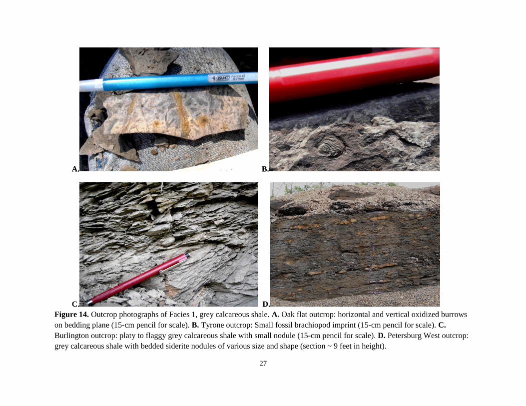
Figure 14. Outcrop photographs of Facies 1, grey calcareous shale. A. Oak flat outcrop: horizontal and vertical oxidized burrows
on bedding plane (15-cm pencil for scale). B. Tyrone outcrop: Small fossil brachiopod imprint (15-cm pencil for scale). C.
Burlington outcrop: platy to flaggy grey calcareous shale with small nodule (15-cm pencil for scale). D. Petersburg West outcrop:
grey calcareous shale with bedded siderite nodules of various size and shape (section ~ 9 feet in height).
28
Facies 2
Facies 2 is medium-grey to black limestone that weathers grey to brown (Table 5). The
limestone beds are frequently micritic or argillaceous and are interbedded with both black and
grey calcareous shale beds (Facies 1 & 3). Limestone beds are thinly laminated to thickly bedded
and exhibit tabular, lenticular (most common), or nodular geometry (Fig. 15). The nodular
geometry is produced by soft sediment compaction between beds of shale. The fossil assemblage
– consisting of crinoids, brachiopods, rugose corals, tabulate corals, bivalves, styliolinids,
gastropods, and bactritid and goniatite cephalopods – exhibits a moderate to moderately low
diversity although the density can be high. The limestone frequently contains trace fossils
(burrow, tracks and trails).
Table 5. Sedimentary Characteristics of Facies 2, Limestone.
Color fresh Medium to dark grey, very dark grey, black
Color weathered Light grey, grey, brown, red staining
Bedding thickness Very thinly to medium bedded, very thinly to thinly bedded, medium to thickly
bedded, thinly laminated to thinly bedded
Bed geometry Beds thin or pinch out, lenticular, nodular or continuous beds
Bedding surfaces Irregular, bumpy
Nodules Calcareous concretions
Body fossils Crinoids, brachiopods, rugose and tabulate corals, bivalves, styliolinids,
gastropods, bactritid and goniatite cephalopods
Trace fossils Bioturbation, burrows, tracks and trails
29
A. B.
C. D.
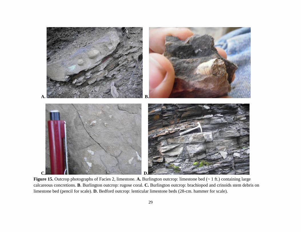
Figure 15. Outcrop photographs of Facies 2, limestone. A. Burlington outcrop: limestone bed (~ 1 ft.) containing large
calcareous concretions. B. Burlington outcrop: rugose coral. C. Burlington outcrop: brachiopod and crinoids stem debris on
limestone bed (pencil for scale). D. Bedford outcrop: lenticular limestone beds (28-cm. hammer for scale).
30
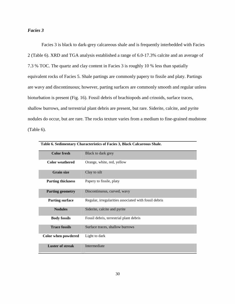
Facies 3
Facies 3 is black to dark-grey calcareous shale and is frequently interbedded with Facies
2 (Table 6). XRD and TGA analysis established a range of 6.0-17.3% calcite and an average of
7.3 % TOC. The quartz and clay content in Facies 3 is roughly 10 % less than spatially
equivalent rocks of Facies 5. Shale partings are commonly papery to fissile and platy. Partings
are wavy and discontinuous; however, parting surfaces are commonly smooth and regular unless
bioturbation is present (Fig. 16). Fossil debris of brachiopods and crinoids, surface traces,
shallow burrows, and terrestrial plant debris are present, but rare. Siderite, calcite, and pyrite
nodules do occur, but are rare. The rocks texture varies from a medium to fine-grained mudstone
(Table 6).
Table 6. Sedimentary Characteristics of Facies 3, Black Calcareous Shale.
Color fresh Black to dark grey
Color weathered Orange, white, red, yellow
Grain size Clay to silt
Parting thickness Papery to fissile, platy
Parting geometry Discontinuous, curved, wavy
Parting surface Regular, irregularities associated with fossil debris
Nodules Siderite, calcite and pyrite
Body fossils Fossil debris, terrestrial plant debris
Trace fossils Surface traces, shallow burrows
Color when powdered Light to dark
Luster of streak Intermediate
31
A. B.
C. D.
Figure 16. Outcrop photographs of Facies 3, black calcareous shale. A. Oakflat outcrop: calcareous black papery shale with small
round siderite nodules (15-cm pencil for scale). B. Petersburg North outcrop: black calcareous shale with round calcareous
nodules. C. Bedford outcrop: unoriented shallow burrows on bedding plane (12-cm knife for scale). D. Petersburg North outcrop:
platy black calcareous shale with discontinuous partings.
32
Facies 4
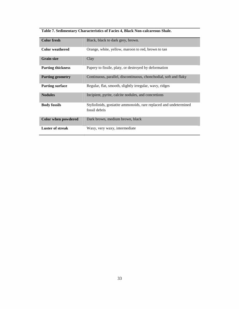
Facies 4 is black to dark-grey, occasionally chocolate-brown non-calcareous shale (Table
7). Orange and white weathering rinds are common. TGA analysis established an average of
9.6% TOC for this facies. Similar to Facies 3, shale partings are typically papery to fissile and
occasionally platy. However, partings are most always parallel and continuous, and parting
surfaces are smooth and regular (Fig. 17). Horizontal lamination is common and small pyrite
lenses and lamina are present in fresh samples. The shale is typically brittle and breaks into
regular sheets or fragments, though it may also weather papery or break into conchoidal
fragments that lack distinctive partings. Nodules are common and diverse in size, shape and
composition. These include round, oblong and spherical nodules of pyrite, calcite and nodules of
undetermined composition. Incipient nodules with oxidation halos are also common. Rare fossils
include styliolinids, goniatite ammonoids, and replaced fossil debris. Woodward (1943)
identified the following genera in black shale of the Marcellus in West Virginia: Styliolina
(zooplankton of uncertain affinity), Bactrites (cephalopod), Buchiola (bivalve), and the
brachiopods Ambocoelia, Leiorhyncus, Lingula, Petrocrania, and Strophalosia. The texture of
the rock is a claystone (Table 7). The shale is often extremely structurally deformed: faulted,
drag-folded, and slickenslided.
33
Table 7. Sedimentary Characteristics of Facies 4, Black Non-calcareous Shale.
Color fresh Black, black to dark grey, brown.
Color weathered Orange, white, yellow, maroon to red, brown to tan
Grain size Clay
Parting thickness Papery to fissile, platy, or destroyed by deformation
Parting geometry Continuous, parallel, discontinuous, chonchodial, soft and flaky
Parting surface Regular, flat, smooth, slightly irregular, wavy, ridges
Nodules Incipient, pyrite, calcite nodules, and concretions
Body fossils Styliolinids, goniatite ammonoids, rare replaced and undetermined
fossil debris
Color when powdered Dark brown, medium brown, black
Luster of streak Waxy, very waxy, intermediate
34
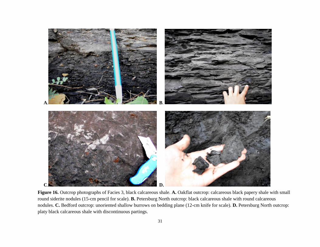
A. B.
C. D.
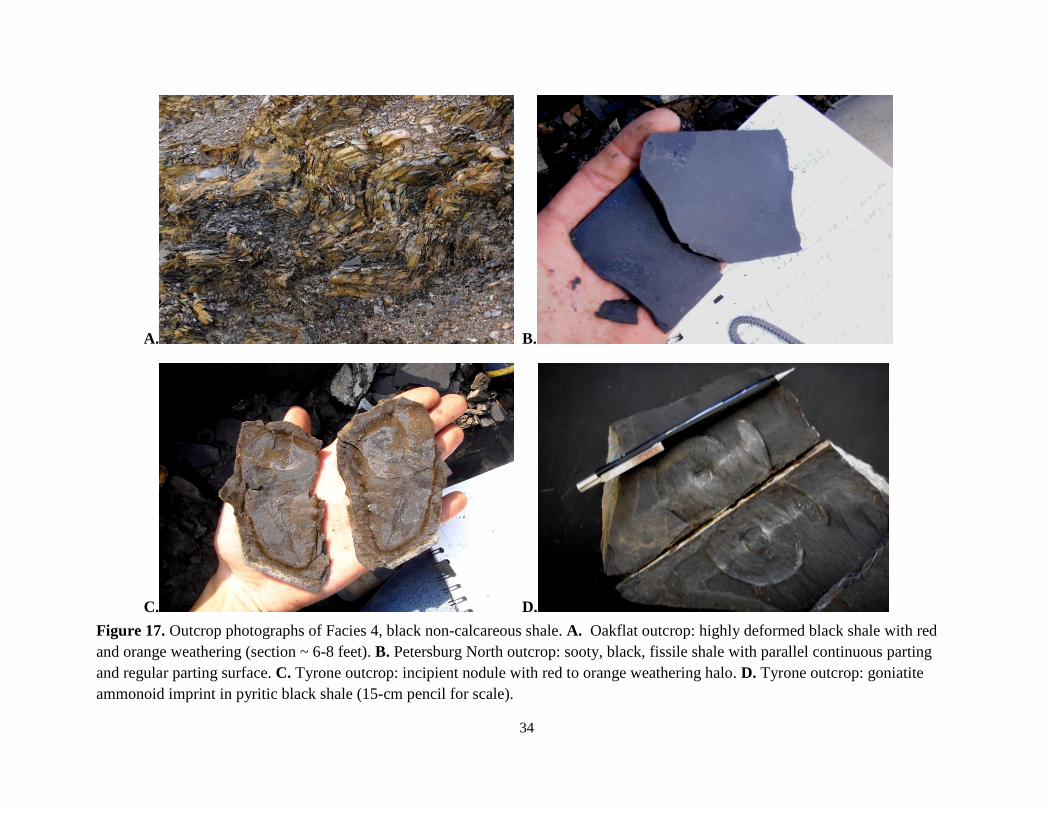
Figure 17. Outcrop photographs of Facies 4, black non-calcareous shale. A. Oakflat outcrop: highly deformed black shale with red
and orange weathering (section ~ 6-8 feet). B. Petersburg North outcrop: sooty, black, fissile shale with parallel continuous parting
and regular parting surface. C. Tyrone outcrop: incipient nodule with red to orange weathering halo. D. Tyrone outcrop: goniatite
ammonoid imprint in pyritic black shale (15-cm pencil for scale).
35
Facies 5
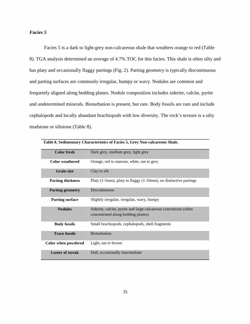
Facies 5 is a dark to light-grey non-calcareous shale that weathers orange to red (Table
8). TGA analysis determined an average of 4.7% TOC for this facies. This shale is often silty and
has platy and occasionally flaggy partings (Fig. 2). Parting geometry is typically discontinuous
and parting surfaces are commonly irregular, bumpy or wavy. Nodules are common and
frequently aligned along bedding planes. Nodule composition includes siderite, calcite, pyrite
and undetermined minerals. Bioturbation is present, but rare. Body fossils are rare and include
cephalopods and locally abundant brachiopods with low diversity. The rock’s texture is a silty
mudstone or siltstone (Table 8).
Table 8. Sedimentary Characteristics of Facies 5, Grey Non-calcareous Shale.
Color fresh Dark grey, medium grey, light grey
Color weathered Orange, red to maroon, white, tan to grey
Grain size Clay to silt
Parting thickness Platy (1-5mm), platy to flaggy (1-10mm), no distinctive partings
Parting geometry Discontinuous
Parting surface Slightly irregular, irregular, wavy, bumpy
Nodules Siderite, calcite, pyrite and large calcareous concretions (often
concentrated along bedding planes)
Body fossils Small brachiopods, cephalopods, shell fragments
Trace fossils Bioturbation
Color when powdered Light, tan to brown
Luster of streak Dull, occasionally intermediate
36
A. B.
C. D.
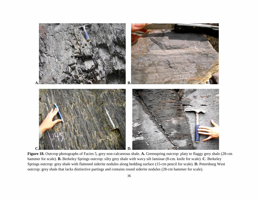
Figure 18. Outcrop photographs of Facies 5, grey non-calcareous shale. A. Greenspring outcrop: platy to flaggy grey shale (28-cm
hammer for scale). B. Berkeley Springs outcrop: silty grey shale with wavy silt laminae (8-cm. knife for scale). C. Berkeley
Springs outcrop: grey shale with flattened siderite nodules along bedding surface (15-cm pencil for scale). D. Petersburg West
outcrop: grey shale that lacks distinctive partings and contains round siderite nodules (28-cm hammer for scale).
37
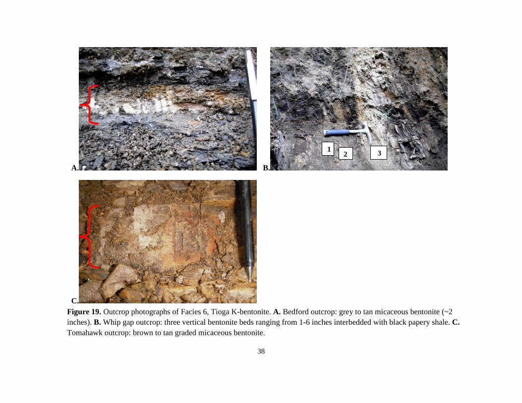
Facies 6
Facies 6 is a K- bentonite (Table 9), an altered volcanic ash that is designated the Tioga
Bentonite (Dennison and Textoris, 1970; Ver Straeten, 2007). These bentonites are tan to grey
and typically weather to tan clay. Sand-sized mica flakes are common. Bentonite beds range
from 3-15 cm in thickness and can be graded or reworked by burrowers. Outcrops in our study
area contain between one and three K-bentonite beds over a stratigraphic interval of 2-5 meters
at the base of the Marcellus.
Table 9. Sedimentary Characteristics of Facies 6, K-bentonite.
Color fresh Tan, brown, light brown, light to dark grey
Color weathered Tan, brown, and grey clay
Grain size Clay to coarse sand
Visible Minerals Mica, pyrite
Bed thickness Very thin to medium bedded (2.5-16 cm)
Sedimentary structures Graded bedding, biogenically reworked
38
A. B.
C.
Figure 19. Outcrop photographs of Facies 6, Tioga K-bentonite. A. Bedford outcrop: grey to tan micaceous bentonite (~2
inches). B. Whip gap outcrop: three vertical bentonite beds ranging from 1-6 inches interbedded with black papery shale. C.
Tomahawk outcrop: brown to tan graded micaceous bentonite.
3 2 1
39
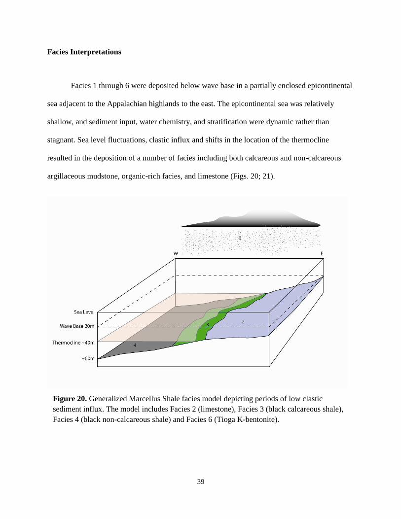
Facies Interpretations
Facies 1 through 6 were deposited below wave base in a partially enclosed epicontinental
sea adjacent to the Appalachian highlands to the east. The epicontinental sea was relatively
shallow, and sediment input, water chemistry, and stratification were dynamic rather than
stagnant. Sea level fluctuations, clastic influx and shifts in the location of the thermocline
resulted in the deposition of a number of facies including both calcareous and non-calcareous
argillaceous mudstone, organic-rich facies, and limestone (Figs. 20; 21).
Figure 20. Generalized Marcellus Shale facies model depicting periods of low clastic
sediment influx. The model includes Facies 2 (limestone), Facies 3 (black calcareous shale),
Facies 4 (black non-calcareous shale) and Facies 6 (Tioga K-bentonite).
40
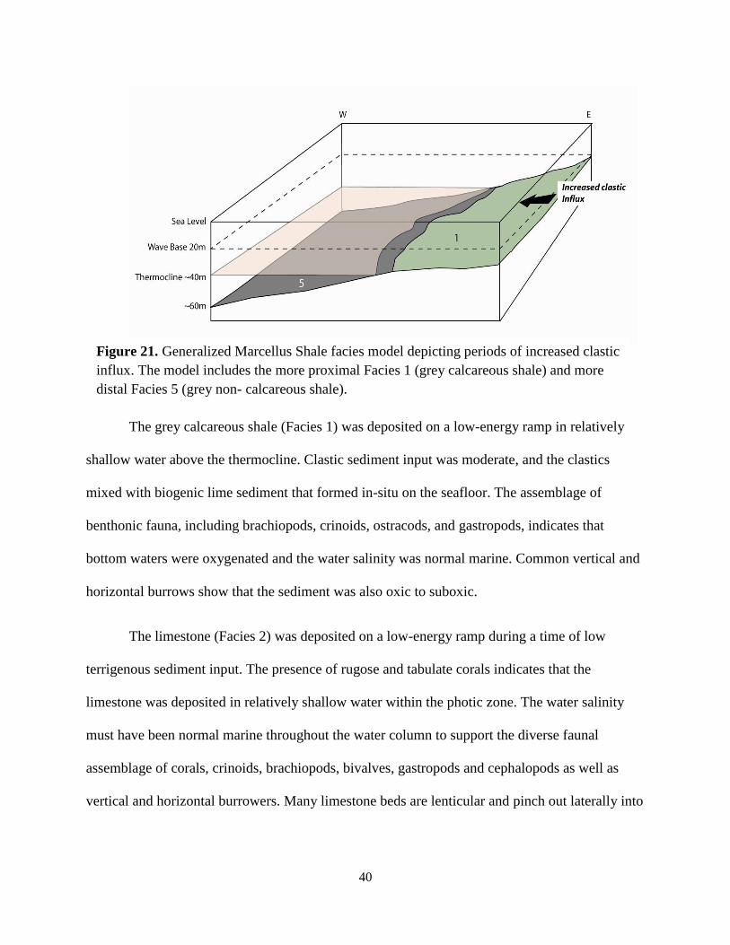
The grey calcareous shale (Facies 1) was deposited on a low-energy ramp in relatively
shallow water above the thermocline. Clastic sediment input was moderate, and the clastics
mixed with biogenic lime sediment that formed in-situ on the seafloor. The assemblage of
benthonic fauna, including brachiopods, crinoids, ostracods, and gastropods, indicates that
bottom waters were oxygenated and the water salinity was normal marine. Common vertical and
horizontal burrows show that the sediment was also oxic to suboxic.
The limestone (Facies 2) was deposited on a low-energy ramp during a time of low
terrigenous sediment input. The presence of rugose and tabulate corals indicates that the
limestone was deposited in relatively shallow water within the photic zone. The water salinity
must have been normal marine throughout the water column to support the diverse faunal
assemblage of corals, crinoids, brachiopods, bivalves, gastropods and cephalopods as well as
vertical and horizontal burrowers. Many limestone beds are lenticular and pinch out laterally into
Figure 21. Generalized Marcellus Shale facies model depicting periods of increased clastic
influx. The model includes the more proximal Facies 1 (grey calcareous shale) and more
distal Facies 5 (grey non- calcareous shale).
41
calcareous shale of Facies 1 and 3. This distribution suggests that the lime sediment mostly
accumulated as pods on an otherwise muddy (shaley) seafloor.
The black calcareous shale (Facies 3) was deposited on the relatively shallow ramp near
the depth of the thermocline (~40 meters). The shallow restricted nature of the epicontinental
sea, high temperatures associated with the Devonian greenhouse climate, and overall low fresh-
water input resulted in a thermocline rather than a permanent halocline or pycnocline (Tyson and
Pearson, 1991). The calcite in Facies 3 may have been formed in-situ or sourced from the
adjacent lime mud environment. This black calcareous shale is typically interbedded with or
grades laterally into Facies 2; therefore, it probably formed in an adjoining environment on the
shallow ramp although water was slightly deeper. Facies 3 was deposited typically below the
thermocline, allowing for better preservation of accumulated organic matter.
The content of terrigenous sediment in Facies 3 indicates that clastic input from the
eastern highlands was reduced. Diminished clastic sediment input allowed for organic matter to
accumulate below the thermocline with minimal dilution. Although terrigenous clastic input was
relatively low, concentrations of quartz in Facies 3 ranges from 37 to 44 percent. This quartz
content may be a result of eolian or diagenetic processes (Schieber et al., 2000; Werne et al.,
2002; Sageman et al., 2003). The thermocline persisted during the deposition of Facies 3;
however, large storms and seasonal mixing occasionally disrupted the thermocline and allowed
oxygen to temporarily mix in the water column. During these times, some benthic organisms and
burrowers could survive.
Black non-calcareous shale (Facies 4) was deposited during a time of a regional sea level
rise. Facies 4 sediments accumulated below the thermocline where the bottom water and

42
sediment were anoxic. Sea level rise caused flooding of the eastern landmass and subsequent
storage of clastic sediment landward, resulting in the low clay content found in Facies 4. Low
clastic sediment input allowed for the deposition of organic matter without dilution. This
relationship is illustrated by the graph of clay content vs. total organic carbon derived from the
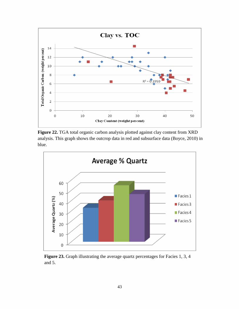
XRD and TGA analyses (Fig. 22). Although terrigenous sediment input was low, Facies 4 has a
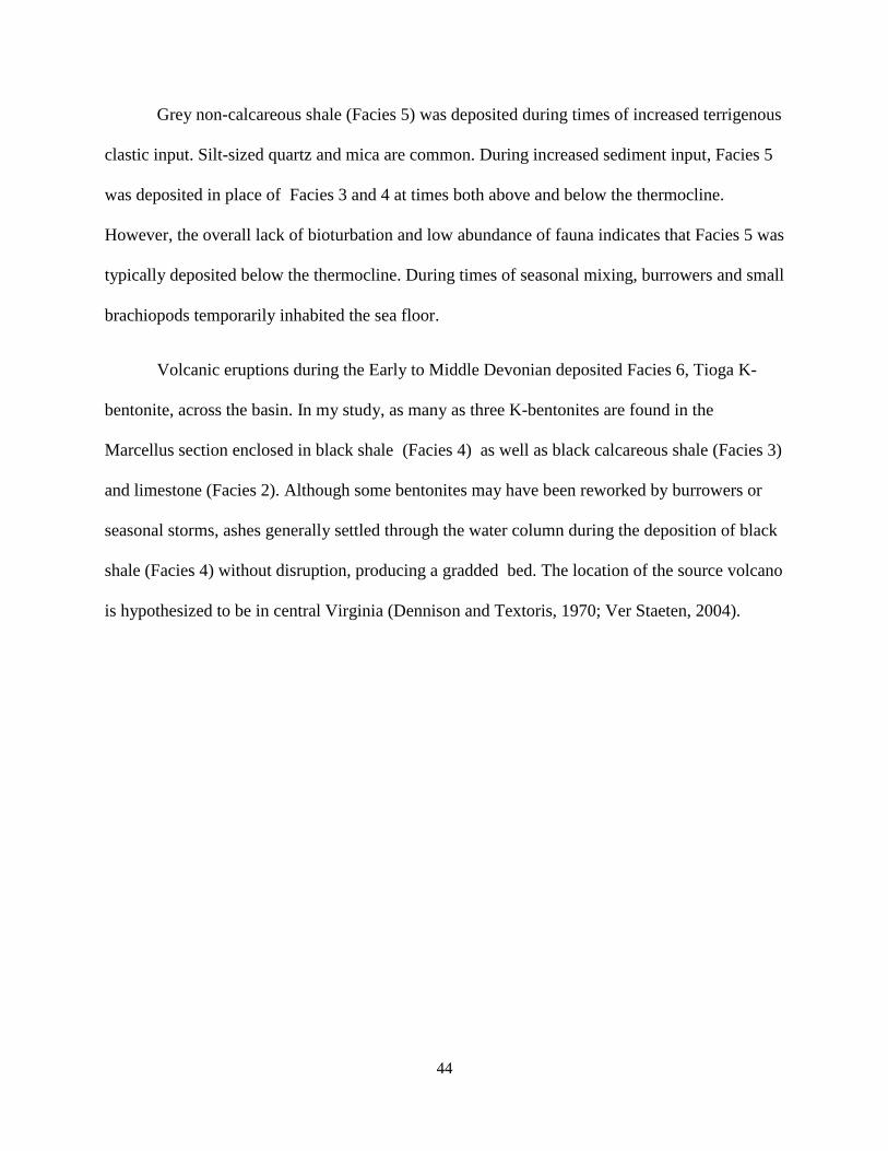
significant amount of quartz (43-75%) as illustrated by Fig. 23. Much of this quartz may have
been sourced from wind-blown eolian silt (Werne et al., 2002; Sageman et al., 2003) or
diagenetic processes (Schieber et al., 2000). Wind-blown nutrients may have been brought into
the basin, creating algal blooms that resulted in a high accumulation of organic matter (Sageman
et al., 2003; Wrightstone, 2010). In addition to lower terrigenous sediment input, increased
primary productivity in the water column may have played a role in the increased total organic
carbon in Facies 4 (Pederson and Calvert, 1990).
Although bottom waters were persistently anoxic, surface waters were oxic, which
allowed for planktonic and nektonic organisms, such as styliolinids and goniatite ammonoids, to
survive. Burrows and bioturbation are absent and bedding planes are smooth and continuous,
indicating a depositional environment where infaunal organisms could not survive.
43
Figure 22. TGA total organic carbon analysis plotted against clay content from XRD
analysis. This graph shows the outcrop data in red and subsurface data (Boyce, 2010) in
blue.
Figure 23. Graph illustrating the average quartz percentages for Facies 1, 3, 4
and 5.
44
Grey non-calcareous shale (Facies 5) was deposited during times of increased terrigenous
clastic input. Silt-sized quartz and mica are common. During increased sediment input, Facies 5
was deposited in place of Facies 3 and 4 at times both above and below the thermocline.
However, the overall lack of bioturbation and low abundance of fauna indicates that Facies 5 was
typically deposited below the thermocline. During times of seasonal mixing, burrowers and small
brachiopods temporarily inhabited the sea floor.
Volcanic eruptions during the Early to Middle Devonian deposited Facies 6, Tioga K-
bentonite, across the basin. In my study, as many as three K-bentonites are found in the
Marcellus section enclosed in black shale (Facies 4) as well as black calcareous shale (Facies 3)
and limestone (Facies 2). Although some bentonites may have been reworked by burrowers or
seasonal storms, ashes generally settled through the water column during the deposition of black
shale (Facies 4) without disruption, producing a gradded bed. The location of the source volcano
is hypothesized to be in central Virginia (Dennison and Textoris, 1970; Ver Staeten, 2004).
45
STRATIGRAPHIC PATTERNS
A composite graphic column (Fig. 24) was created based on correlations of 15 partial
Marcellus Shale sections (Fig. 25-39) using key beds and combining the average thicknesses of
the assosciated lithofacies. Each outcrop figure contains a vertical distribution of facies, fossil
content, sedimentary features, concretions, and outcrop notes as well as a total gamma-ray curve,
spectral gamma-ray curve (K, Th, U), and infomal stratigraphic units. Six stratigraphic units (A-
F) are recognized within the Marcellus Shale.
Unit A
Unit A is the lowermost unit within the Marcellus Shale and has an average thickness of
5.5 meters. This is a transgressional unit overlying the Needmore Shale. Unit A consists of black
calcareous shale of Facies 3, limestone of Facies 2, and beds of Facies 1, grey calcareous shale.
Facies 6, the Tioga Bentonite, is also found within this unit. Interbedding of Facies 2 and 3 was
caused by slight fluctuations of sea level, and the occasional occurrence of Facies 1 can be tied to
increased sediment input during slight progradation of the shoreline. During deposition of Unit A
the water increased to a depth between fair-weather wave base (~20 meters) to near the position
of the thermocline (~40 meters) (Tyson and Pearon, 1991).
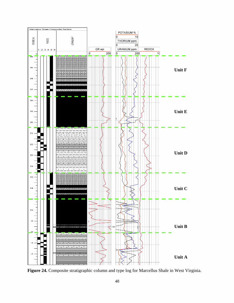
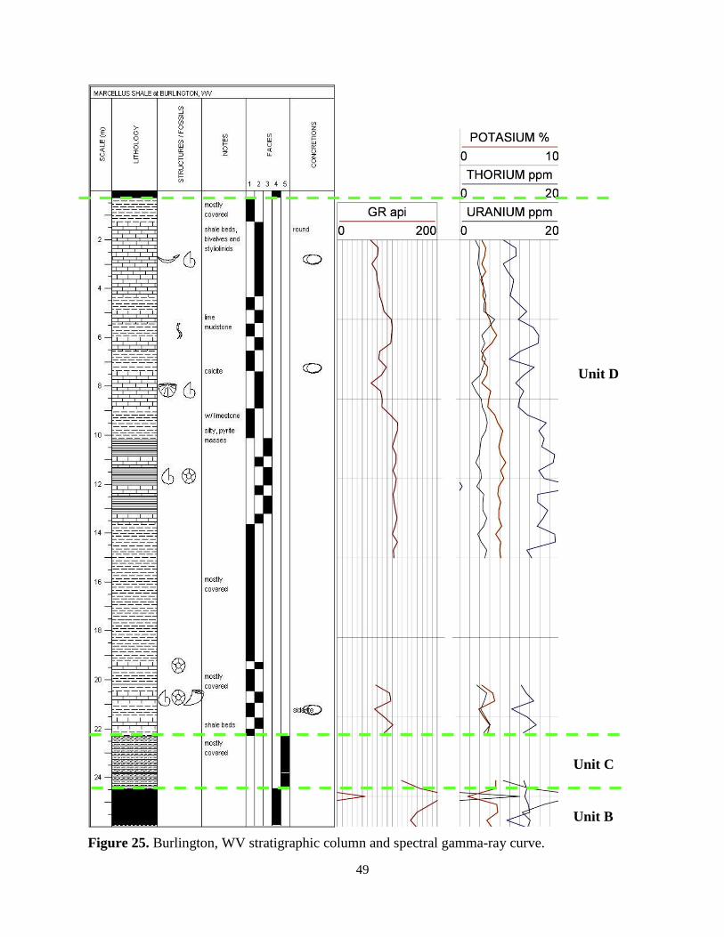
Unit B
Unit B has an average thickness of 7.0 meters. This unit consists entirely of Facies 4,
non-calcareous black shale, plus several K-bentonite beds (Facies 6) and represents a continuing
sea level rise from the underlying Unit A. During the deposition of Unit B water depth was on
the order of 60 meters, where the bottom water was generally anoxic and near the maximum
depth of seasonal mixing. Maximum effective anoxia on modern shelves occurs mostly in water
46
less than 60 meters deep and the maximum depth of winter mixing in the semi-enclosed Black
Sea is less than 60 meters (Tyson and Pearson, 1991; Kara et al., 2009).
Unit C
Unit C consists of grey non-calcareous shale (Facies 5) and black non-calcareous shale
(Facies 4) and has an average thickness of 4.0 meters. The lower contact of Unit C is gradational:
Facies 4 decreases while Facies 5 becomes more abundant. This change corresponds with a
decrease in total gamma-ray values from Unit B up through Unit C, most notably in the
concentration of uranium. These vertical changes suggest that a greater amount of detrital quartz
silt and mica had entered the sea and diluted the organic material. The increased influx of clastics
is tied to the progradation of the eastern shoreline into the foreland basin.
Unit D
Unit D typically contains interbedded rocks of grey calcareous shale (Facies 1) and very
thin to thickly bedded limestone (Facies 2). The average thickness of this unit is 8.0 meters, yet
this unit can be as thin as 2.0 meters or as thick as 20 meters. Black calcareous shale (Facies 3) is
also present but is minor. This unit was deposited during a time of regional sea level fall, when
water depth shallowed to near wave base (~20 meters) and only rarely exceeded the depth of the
thermocline (~40 meters) during the depositon of Facies 3. Interbedding of Facies 1 and 2
represents fluctuations in sediment supply. The limestones of this unit are notably more
argillaceous than the limestones of Unit A. This unit has a wide range of character over the study
area. Some limestone and shale packages exhibit repeating coarsening-upward cycles, where
calcareous shale passes vertically into thin argillaceous limestone and thicker fossiliferous
limestone (Fig. 25). Other beds used for correlation of Unit D contain large calcite concretions or
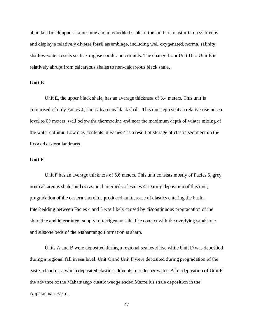
47
abundant brachiopods. Limestone and interbedded shale of this unit are most often fossilifeous
and display a relatively diverse fossil assemblage, including well oxygenated, normal salinity,
shallow-water fossils such as rugose corals and crinoids. The change from Unit D to Unit E is
relatively abrupt from calcareous shales to non-calcareous black shale.
Unit E
Unit E, the upper black shale, has an average thickness of 6.4 meters. This unit is
comprised of only Facies 4, non-calcareous black shale. This unit represents a relative rise in sea
level to 60 meters, well below the thermocline and near the maximum depth of winter mixing of
the water column. Low clay contents in Facies 4 is a result of storage of clastic sediment on the
flooded eastern landmass.
Unit F
Unit F has an average thickness of 6.6 meters. This unit consists mostly of Facies 5, grey
non-calcareous shale, and occasional interbeds of Facies 4. During deposition of this unit,
progradation of the eastern shoreline produced an increase of clastics entering the basin.
Interbedding between Facies 4 and 5 was likely caused by discontinuous progradation of the
shoreline and intermittent supply of terrigenous silt. The contact with the overlying sandstone
and silstone beds of the Mahantango Formation is sharp.
Units A and B were deposited during a regional sea level rise while Unit D was deposited
during a regional fall in sea level. Unit C and Unit F were deposited during progradation of the
eastern landmass which deposited clastic sediments into deeper water. After deposition of Unit F
the advance of the Mahantango clastic wedge ended Marcellus shale deposition in the
Appalachian Basin.
48
Figure 24. Composite stratigraphic column and type log for Marcellus Shale in West Virginia.
Unit D
Unit E
Unit F
Unit C
Unit B
Unit A
49
Figure 25. Burlington, WV stratigraphic column and spectral gamma-ray curve.
Unit B
Unit C
Unit D
50
Figure 26. Springfield, WV stratigraphic column and spectral gamma-ray curve.
Unit D
Unit E
51
Figure 27. Greenspring, WV stratigraphic column and spectral gamma-ray curve.
Unit F
52
Unit A
Unit B
Figure 28. Petersburg North, WV stratigraphic column and spectral gamma-ray curve.
53
Unit D
Unit C
Figure 29. Tyrone, PA stratigraphic column and spectral gamma-ray curve.
54
Figure 30. Whip Gap, WV stratigraphic column and spectral gamma-ray curve.
Unit A
55
Unit B
Unit A
Figure 31. Bedford, PA stratigraphic column and spectral gamma-ray curve.
56
Figure 32. Hiser, WV stratigraphic column. Spectral gamma-ray was not used at this location,
Unit E
Unit D
57
Figure 33. South Branch of the Potomac, WV stratigraphic column and spectral gamma-ray curve.
Unit E
Unit F
58
Figure 34. Oak Flat, WV stratigraphic column and spectral gamma-ray curve.
Unit A
Unit B
59
Figure 35. Berkeley Springs, WV stratigraphic column and spectral gamma-ray curve.
Unit F?
Unit D
Unit C
60
Transition to Upper Milboro
Figure 36. Frost, WV stratigraphic column. Spectral gamma-ray was not used at this location.
61
Figure 37. McCoole, MD stratigraphic column and spectral gamma-ray curve.
Unit B
Unit D
Unit F
Unit E
62
Figure 38. Tomahawk, WV stratigraphic column and spectral gamma-ray curve.
Unit B
63
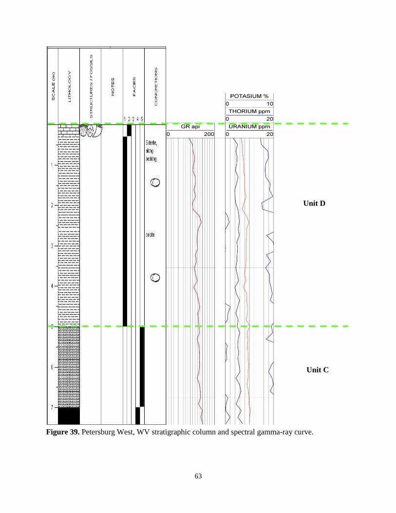
Figure 39. Petersburg West, WV stratigraphic column and spectral gamma-ray curve.
Unit D
Unit C
64
GAMMA-RAY CORRELATIONS
Gamma-ray and spectral gamma-ray logs were created from scintillometer data
collected at 15 partial outcrops (Fig. 25-39) and a gamma-ray type log was compiled for the
composite section of the Marcellus Shale in the study area (Fig. 24). The spectral gamma-ray
data for each outcrop was converted to API units using the following parameters: uranium ppm *
6.69, thorium ppm * 2.54, and potassium % * 10.54 (Korsbech, 2002). The outcrop spectral
gamma-ray API units were then summed to create a total gamma-ray curve (U + Th + K) for
each outcrop (track 1). Individual concentrations of radioactive elements including uranium
(ppm), throium (ppm) and potassium (%) are displayed in track 2. The Th/U ratio (track 3) is
used as a relative measure of redox conditions during deposition. Uranium is insoluble under
reducing conditions and soluble under oxidizing conditions whereas throium 4+
is insoluble under
both reducing and oxidizing conditons. Therefore, comparing the relative amount of thorium to
uranium (Th/U ratio) results in a relative measure of redox potential for the depositional
environment (Adams and Weaver, 1958). A Th/U ratio values of two or less indicates deposition
under anoxic conditions whereas values of seven or greater indicates deposition under oxic
conditions (Adams and Weaver, 1958). Values between 2 and 7 indicate suboxic to dyoxic
conditons. The composite type log was then used to compare and correlate each outcrop unit of
the Marcellus Shale to nearby subsurface wells in the Appalachian Basin (Fig. 1).
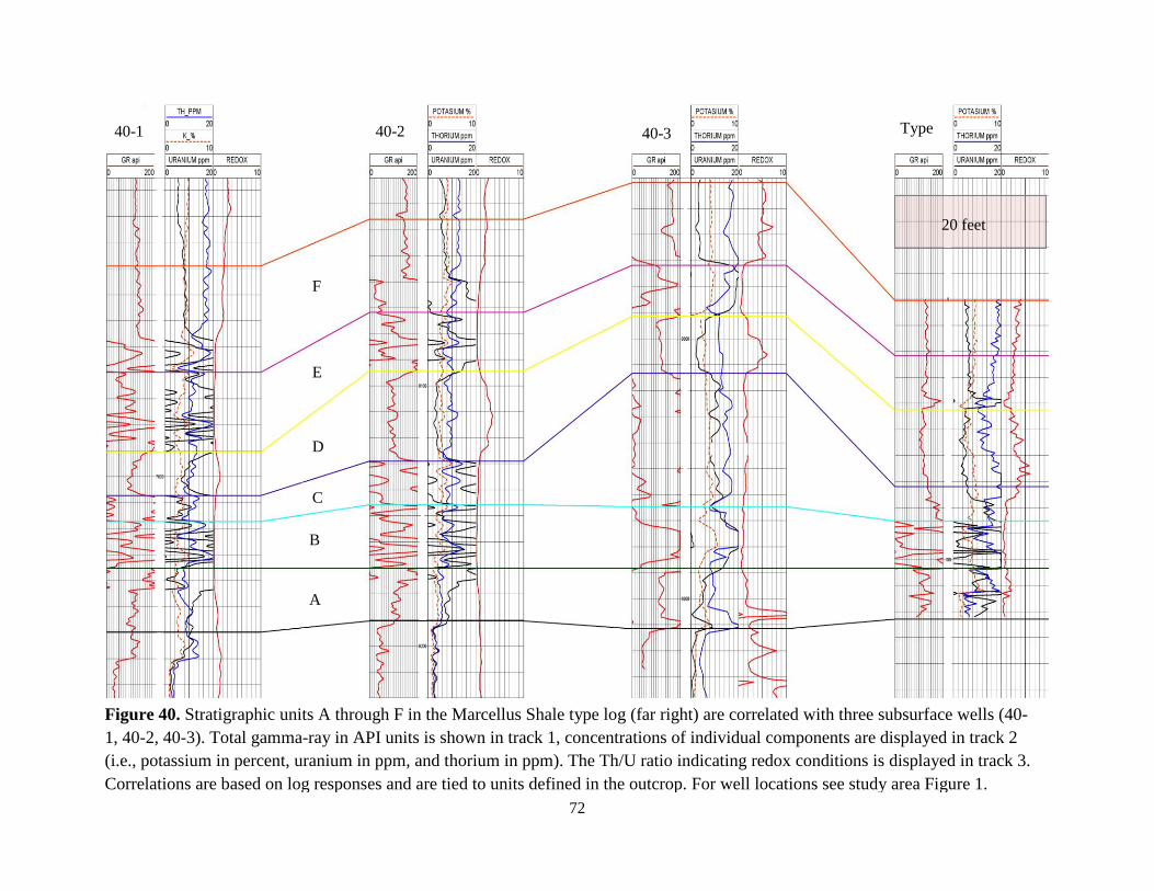
Unit A
The type log for Unit A in outcrop has total gamma-ray values that range between 60-
162 API units (Fig. 24). Though uranium concentrations can be as low as 4.1 ppm, there are
peaks at 15, 18 and 22 ppm. The higher uranium values are assosciated with black calcareous
65
shale (Facies 3), whereas the lower values are typically assosciated with limestone (Facies 2) and
grey calcareous shale (Facies 1). The type log shows an abrupt increase in potassium and
thorium concentrations in the middle of the unit. Gamma-ray character and thicknesses change
considerably from the outcrop to the subsurface, even between wells spaced 7 miles apart (Fig.
41). Nevertheless, the total subsurface gamma-ray values and uranium concentrations are
comparable to the type log and allow for correlation of Unit A into the subsurface. The gamma-
ray profile for the upper contact of this unit is gradational.
The Unit A type log and subsurface logs have similar gamma-ray values; however, the
thicknesses and log shape change. Thickness changes can be attributed to sediment supply and
shifts in the thermocline. These result in varying development of Facies 1, 2 and 3. The overall
increase in potassium (K) and thorium (Th) in the type log are related to increased abundance of
clastic sediment in Facies 1 towards the top of the unit. Th/U ratio values of roughly two
correspond with the increase in Th and K in the middle of the unit and suggest a period of
slightly less anoxic deposition. The easternmost well (Fig. 40-3) shows similar high redox values
indicating deposition under more oxic conditions. However, wells farther into the basin (Fig. 40-
1; Fig. 40-2) have redox numbers that represent deposition under anoxic conditions. Therefore,
westward the Marcellus exhibits decreased development of limestone (Facies 2) and grey
calcareous shale (Facies 1) and increased development of black calcareous shale (Facies 3) and
black non-calcareous shale (Facies 4).
Unit B
The type log for Unit B in outcrop has total gamma-ray values that range between 170-
602 API units, though readings are most often greater than 200 API. These elevated gamma-ray
66
values are related to increased uranium and thorium concentrations. Outcrop uranium
concentrations average 30 ppm and are as high as 77 ppm, whereas thorium values reach 42
ppm. The higher gamma-ray values of Unit B correspond nicely with nearby subsurface well
logs where total gamma-ray values reach 662 API, uranium 77 ppm, and thorium 24 ppm. In
both the outcrop type log and subsurface well logs, the maximum thorium and uranium values
occur together in the base of Unit B (Fig. 40). The average thickness of Unit B in outcrop is
roughly 23 feet. Unit B thickness remains similar from outcrop to subsurface; however, high
gamma zones ( >200 API) within the unit become thicker westward into the basin. The contact
with the overlying unit is gradational (Fig. 40).
The elevated uranium is assosciated with an increase in organic matter in the rock
(Swanson, 1960; Schmoker, 1981). The very high organic content in Unit B creates a rapid
increase in the total gamma-ray profile that can be traced into the subsurface. The increased
thorium concentrations seen at the base of this unit indicate an increased clay content and may be
related to the presence of K-bentonites. The Th/U ratio values are less than one in the outcrop
type log and indicate that Unit B was deposited under consistently anoxic conditions, although
small fluctuations existed. The Th/U ratio in subsurface wells indicates deposition under similar
consistently anoxic conditions; however, redox values do not fluctuate. Increased thickness of
high gamma-ray zones in the subsurface may be associated with deposition in deeper water (~60
meters) or greater primary productivity in the surface water as well as diminished clastic influx
due to increased distance from the eastern source. Even during periods of low clastic influx, the
proximal facies contain more clastics than the distal equivalents.
67
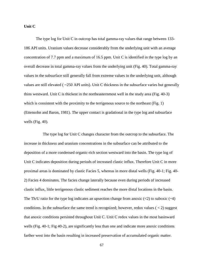
Unit C
The type log for Unit C in outcrop has total gamma-ray values that range between 133-
186 API units. Uranium values decrease considerably from the underlying unit with an average
concentration of 7.7 ppm and a maximum of 16.5 ppm. Unit C is identified in the type log by an
overall decrease in total gamma-ray values from the underlying unit (Fig. 40). Total gamma-ray
values in the subsurface still generally fall from extreme values in the underlying unit, although
values are still elevated ( ~250 API units). Unit C thickness in the subsurface varies but generally
thins westward. Unit C is thickest in the northeasternmost well in the study area (Fig. 40-3)
which is consistent with the proximity to the terrigenous source to the northeast (Fig. 1)
(Ettensohn and Baron, 1981). The upper contact is gradational in the type log and subsurface
wells (Fig. 40).
The type log for Unit C changes character from the outcrop to the subsurface. The
increase in thickness and uranium concentrations in the subsurface can be attributed to the
deposition of a more condensed organic-rich section westward into the basin. The type log of
Unit C indicates deposition during periods of increased clastic influx. Therefore Unit C in more
proximal areas is dominated by clastic Facies 5, whereas in more distal wells (Fig. 40-1; Fig. 40-
2) Facies 4 dominates. The facies change laterally because even during periods of increased
clastic influx, little terrigenous clastic sediment reaches the more distal locations in the basin.
The Th/U ratio for the type log indicates an upsection change from anoxic (<2) to suboxic (~4)
conditions. In the subsurface the same trend is recognized; however, redox values ( < 2) suggest
that anoxic conditions persisted throughout Unit C. Unit C redox values in the most basinward
wells (Fig. 40-1; Fig 40-2), are significantly less than one and indicate more anoxic conditions
farther west into the basin resulting in increased preservation of accumulated organic matter.
68
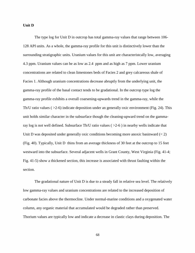
Unit D
The type log for Unit D in outcrop has total gamma-ray values that range between 106-
128 API units. As a whole, the gamma-ray profile for this unit is distinctively lower than the
surrounding stratigraphic units. Uranium values for this unit are characteristcally low, averaging
4.3 ppm. Uranium values can be as low as 2.4 ppm and as high as 7 ppm. Lower uranium
concentrations are related to clean limestones beds of Facies 2 and grey calcareous shale of
Facies 1. Although uranium concentrations decrease abruptly from the underlying unit, the
gamma-ray profile of the basal contact tends to be gradational. In the outcrop type log the
gamma-ray profile exhibits a overall coarsening-upwards trend in the gamma-ray, while the
Th/U ratio values ( >2-6) indicate deposition under an generally oxic environment (Fig. 24). This
unit holds similar character in the subsurface though the cleaning-upward trend on the gamma-
ray log is not well defined. Subsurface Th/U ratio values ( >2-6 ) in nearby wells indicate that
Unit D was deposited under generally oxic conditions becoming more anoxic basinward (< 2)
(Fig. 40). Typically, Unit D thins from an average thickness of 30 feet at the outcrop to 15 feet
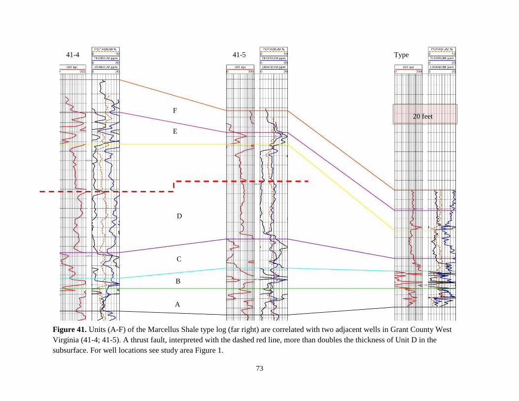
westward into the subsurface. Several adjacent wells in Grant County, West Virginia (Fig. 41-4;
Fig. 41-5) show a thickened section, this increase is associated with thrust faulting within the
section.
The gradational nature of Unit D is due to a steady fall in relative sea level. The relatively
low gamma-ray values and uranium concentrations are related to the increased deposition of
carbonate facies above the thermocline. Under normal-marine conditions and a oxygenated water
column, any organic material that accumulated would be degraded rather than preserved.
Thorium values are typically low and indicate a decrease in clastic clays during deposition. The
69
decrease of thickness from the type log to the subsurface is due to less developed carbonate
facies in more distal parts of the basin.
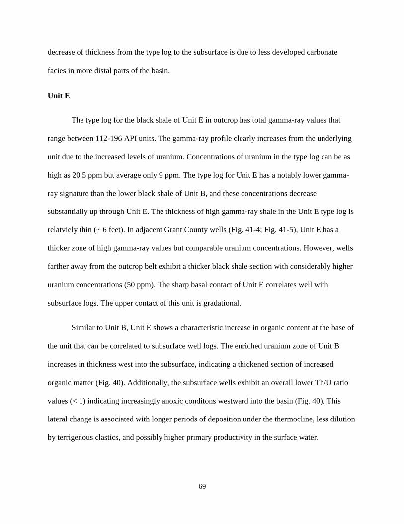
Unit E
The type log for the black shale of Unit E in outcrop has total gamma-ray values that
range between 112-196 API units. The gamma-ray profile clearly increases from the underlying
unit due to the increased levels of uranium. Concentrations of uranium in the type log can be as
high as 20.5 ppm but average only 9 ppm. The type log for Unit E has a notably lower gamma-
ray signature than the lower black shale of Unit B, and these concentrations decrease
substantially up through Unit E. The thickness of high gamma-ray shale in the Unit E type log is
relatviely thin (~ 6 feet). In adjacent Grant County wells (Fig. 41-4; Fig. 41-5), Unit E has a
thicker zone of high gamma-ray values but comparable uranium concentrations. However, wells
farther away from the outcrop belt exhibit a thicker black shale section with considerably higher
uranium concentrations (50 ppm). The sharp basal contact of Unit E correlates well with
subsurface logs. The upper contact of this unit is gradational.
Similar to Unit B, Unit E shows a characteristic increase in organic content at the base of
the unit that can be correlated to subsurface well logs. The enriched uranium zone of Unit B
increases in thickness west into the subsurface, indicating a thickened section of increased
organic matter (Fig. 40). Additionally, the subsurface wells exhibit an overall lower Th/U ratio
values (< 1) indicating increasingly anoxic conditons westward into the basin (Fig. 40). This
lateral change is associated with longer periods of deposition under the thermocline, less dilution
by terrigenous clastics, and possibly higher primary productivity in the surface water.
70
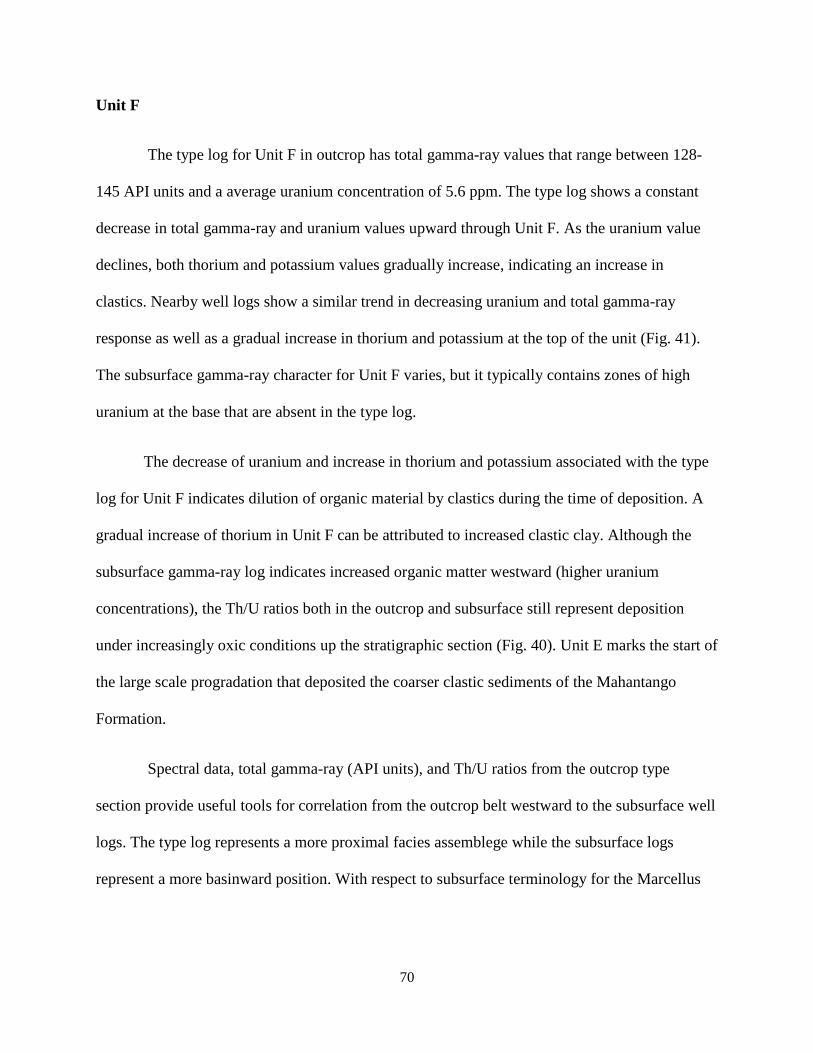
Unit F
The type log for Unit F in outcrop has total gamma-ray values that range between 128-
145 API units and a average uranium concentration of 5.6 ppm. The type log shows a constant
decrease in total gamma-ray and uranium values upward through Unit F. As the uranium value
declines, both thorium and potassium values gradually increase, indicating an increase in
clastics. Nearby well logs show a similar trend in decreasing uranium and total gamma-ray
response as well as a gradual increase in thorium and potassium at the top of the unit (Fig. 41).
The subsurface gamma-ray character for Unit F varies, but it typically contains zones of high
uranium at the base that are absent in the type log.
The decrease of uranium and increase in thorium and potassium associated with the type
log for Unit F indicates dilution of organic material by clastics during the time of deposition. A
gradual increase of thorium in Unit F can be attributed to increased clastic clay. Although the
subsurface gamma-ray log indicates increased organic matter westward (higher uranium
concentrations), the Th/U ratios both in the outcrop and subsurface still represent deposition
under increasingly oxic conditions up the stratigraphic section (Fig. 40). Unit E marks the start of
the large scale progradation that deposited the coarser clastic sediments of the Mahantango
Formation.
Spectral data, total gamma-ray (API units), and Th/U ratios from the outcrop type
section provide useful tools for correlation from the outcrop belt westward to the subsurface well
logs. The type log represents a more proximal facies assemblege while the subsurface logs
represent a more basinward position. With respect to subsurface terminology for the Marcellus
71
Shale, Units A-C correlate to the Union Springs Formation, Unit D the Cherry Valley Member,
and Units E-F the Oatka Creek Formation (Ver Straeten et al., 1994).
72
Figure 40. Stratigraphic units A through F in the Marcellus Shale type log (far right) are correlated with three subsurface wells (40-
1, 40-2, 40-3). Total gamma-ray in API units is shown in track 1, concentrations of individual components are displayed in track 2
(i.e., potassium in percent, uranium in ppm, and thorium in ppm). The Th/U ratio indicating redox conditions is displayed in track 3.
Correlations are based on log responses and are tied to units defined in the outcrop. For well locations see study area Figure 1.
A
B
C
D
E
F
20 feet
40-1 40-2 40-3 Type
73
Figure 41. Units (A-F) of the Marcellus Shale type log (far right) are correlated with two adjacent wells in Grant County West
Virginia (41-4; 41-5). A thrust fault, interpreted with the dashed red line, more than doubles the thickness of Unit D in the
subsurface. For well locations see study area Figure 1.
20 feet
A
B
C
D
E
F
41-4 41-5 Type
74
CONCLUSIONS
The Marcellus Shale outcrops in the study area consist of six interbedded lithofacies
(Facies 1-6). Facies deposition is primarily based on terrigenous sediment supply and shifts in
the location of the thermocline which is dependent on sea level.
Facies 1 is light to dark grey calcareous shale, commonly bioturbated. Deposited in a
foreland ramp environment below wave base (~20 meters) but above the thermocline
(~40 meters). Deposited under normal marine conditions with a moderate supply of
terrigenous clastic sediment.
Facies 2 is dark grey to black micritic limestone occasionally fossilferous or argillaceous.
Deposited in a forland ramp environment below wave base and above the thermocline.
Commonly forms in pods on a muddy shelf resulting in a facies mosiac. The fossil
assemblage indicates a normal marine, well oxygenated water column, with low
terrigenous input.
Facies 3 is dark grey to black calcareous shale. Rare biotubation, benthonic organisms,
and fossil debris. Typically deposited below the thermocline at times of decreased clastic
influx. The bottom water was mostly oxygen depleted although seasonal mixing and
large storms occasionally disrupted the thermocline resulting in mixing of oxygen-rich
surface water.
Facies 4 is black to dark grey occasionally chocolate-brown, non-calcareous shale with
rare necktonic fossils. Deposited in oxygen depleted bottom-water well below the
thermocline during periods of low terrigenous clastic input. Water depth was roughly 60
75
meters, deeper than seasonal mixing depths, but within the depth of most modern-day
anoxic seas.
Facies 5 is light to dark grey, silty, non-calcareous shale. Typically deposited below the
thermocline in place for Facies 3 and 4 during times of increased clastic influx. Water
was mostly anoxic, though intermittent storm and seasonal mixing events allowed for
deposition in more oxic conditions.
Facies 6 the Tioga K-bentonite is tan, brown to grey, and composed of clay to sands sized
grains of mica. Up to three bentonite ash beds are identified at the base of the formation
that were sourced from a Volcano in Central Virginia.
These lithofacies were stacked vertically into Units A through F which can be identified in
terms of subsurface stratigraphy terminology. The dominant facies in Units A-C which
represents the Union Springs Formation include black calcareous shale (Facies 3), black non-
calcareous shale (Facies 4) and grey non-calcareous shale (Facies 5). The dominant facies in
Unit D which represents the Cherry Valley Member includes limestone (Facies 2) and grey
calcareous shale (Facies 1). The dominant facies in Units E-F which represents the Oatka Creek
Formation includes black non-calcareous shale (Facies 4) and grey non-calcareous shale (Facies
5).
Using a handheld spectral gamma-ray tool to create an outcrop type log allows for
stratigraphic correlations from the outcrop belt to the nearby subsurface. Concentrations of
radioactive elements in similar facies are approximately the same in the outcrop as in the
subsurface. Therefore, outcrop Units A-F can be readily identified in the subsurface. Basinward,
76
these units exhibit an overall decrease in thickness of clastic-dominated (Facies 5) and carbonate
(Facies 1 and 2) lithofacies as well as an increase in organic-rich (Facies 4) lithofacies. These
lateral changes correspond with the greater distance from the terrigenous source and deposition
in increasingly deep water beneath the thermocline.
77
REFERENCES
Adams, J. A. S., and C. Weaver, 1958, Thorium-to-uranium ratios as indicators of sedimentary
processes; example of concept of geochemical facies: Bulletin of the American
Association of Petroleum Geologists, v. 42, p. 387-430.
Algeo, T., and S. Scheckler, 1998, Terrestrial-marine teleconnections in the Devonian; links
between the evolution of land plants, weathering processes, and marine anoxic events:
Philosophical Transactions - Royal Society of London. Biological Sciences, v. 353, p.
113-130.
Basan, P. B., D. L. Kissling, K. D. Hemsley, K. G. Dow, M. S. Chaiffetz, P. Isaacson, S. Barrett,
and L. Carne, 1980, Geological study and reservoir evaluation of Early Devonian
formations of the Appalachian, Robertson Research (U.S.) Inc., p. 263.
Blakey, R., 2011, Middle Devonian (385Ma), North American Paleogeogprahy.
http://jan.ucc.nau.edu/rcb7/nam.html, accessed May 21st, 2011.
Boswell, R., 1996, Play Uds: Upper Devonian black shales, in Roen, J.B. and Walker, B.J., eds.,
Atlas of major appalachian gas plays: West Virginia Geologic and Economic Survey,
Publication V-25, p. 93–99.
Boyce, M. L., Carr, T. R., Singh, V, 2010, The Depositional Dynamics of the Middle Devonian
Marcellus Interval Using a Petrophysical and Stratigraphic Analysis of the Sub-surface in
West Virginia and Southwestern Pennsylvania, West Virginia University, dissertation, p.
1-159.
Campbell, C. V., 1967, LAMINA, LAMINASET, BED AND BEDSET: Sedimentology, v. 8, p.
7-26.
Demaison, G., and G. Moore, 1980, Anoxic environments and oil source bed genesis, AAPG
Bulletin, United States (USA), American Association of Petroleum Geologists, v. 64, p.
1179-1209.
Dennison, J. M., 1960, Stratigraphy of Devonian Onesquethaw stage in West Virginia, Virginia
and Maryland: Dissertation Abstracts, v. 21, no. 3, p. 593; University of Wisconsin-
Madison, unpub. dissertation, p. 339.
Dennison, J., and D. Textoris, 1970, Devonian tioga tuff in Northeastern United States: Bulletin
of Volcanology, v. 34, p. 289-294.
Dennison, J. M., and D. A. Textoris, 1977, Tioga Bentonite time-marker associated with
Devonian shales in Appalachian Basin: Preprints, First Eastern gas shales symposium, p.
113-129.
78
Dennison, J., 1985, Catskill Delta shallow marine strata, in Woodrow, D.L., and Sevon, W.D.,
eds., The Catskill Delta: Geological Society of America special paper 201, p. 91-106
De Witt, W., Jr., W. Perry, and L. Wallace, 1975, Oil and gas data from Devonian and Silurian
rocks in the Appalachian Basin, Miscellaneous Investigations Series - U. S. Geological
Survey, United States U. S. Geological Survey, Reston, VA, United States
De Witt, W., Jr., J. Roen, and L. Wallace, 1993, Stratigraphy of Devonian black shales and
associated rocks in the Appalachian Basin, in J. Roen, and R. Kepferle, eds., U. S.
Geological Survey Bulletin, United States, U. S. Geological Survey, Reston, VA, United
States p. B1-B57.
Engelder, T., 2008, Structural geology of the Marcellus and other Devonian gas shales, geologic
conundrums involving joints, layer-parallel shortening strain, and the contemporary
tectonic stress field: Eastern Section Meeting Field Trip AAPG-SEG, p. 96.
Engelder, T., G.G. Lash, 2011, Thickness trends and sequence stratigraphy of the Middle
Devonian Marcellus Formation, Appalachian Basin: Implications for Acadian foreland
basin evolution, AAPG Bulletin p. 61-103.
Ettensohn, F.R., 1985, The Catskill Delta complex and the Acadian orogeny, in Woodrow, D.L.,
and Sevon, W.D., eds., The Catskill Delta: Geological Society America Special paper
201, p. 39–49
Ettensohn, F., 1987, Rates of relative plate motion during the Acadian Orogeny based on the
spatial distribution of black shales: Journal of Geology, v. 95, p. 572-582.
Ettensohn, F., 1998, Compressional tectonic controls on epicontinental black-shale deposition;
Devonian-Mississippian examples from North America in J. Schieber, W. Zimmerle, and
P. Sethi, eds., Shales and mudstones; I, Basin studies, sedimentology, and paleontology,
E. Schweizerbart'sche Verlagsbuchhandlung Naegele u. Obermiller, Stuttgart, p. 109-
128.
Ettensohn, F., 2008, Tectonism, estimated water depths, and the accumulation of organic matter
in the Devonian-Mississippian black shales of the Northern Appalachian Basin, AAPG,
Eastern Section Meeting, Pittsburgh PA.
Ettensohn, F., and L. Barron, 1981, Tectono-climatic model for origin of Devonian-
Mississippian black gas shales of east-central United States: AAPG Bulletin, v. 65, p. 1-
83.
Ettensohn, F. R., Miller, M.L., Dillman, S.B., Elam, T.D., Geller, K.L., Swager, D.R.,
Markowitz, G., Woock, R.D., and Barron, L.S. 1988, Characterization and implications
of the Devonian-Mississippian black shale sequence, eastern and central Kentucky,
U.S.A. : Pycnocline, transgression, regression, and tectonism, in McMillan, N.J., Embry,
79
A.F., and Glass, D.J., eds., Devonian of the World: Canadian Society of Petroleum
Geologists Memoir 14, v. 2, p. 323-345.
Faill, R. T., 1985, The Acadian orogeny and the Catskill delta, inWoodrow, D. L., and Sevon,W.
D., eds., The Catskill Delta: Geological Society of America Special Paper 201, p. 15–37.
Faill, R., 1997, A geologic history of the north-central Appalachians; Part 2, The Appalachian
Basin from the Silurian through the Carboniferous: American Journal of Science, v. 297,
p. 729-761.
Gao, D., R. C. Shumaker, and T. H. Wilson, 2000, Along-Axis Segmentation and Growth
History of the Rome Trough in the Central Appalachian Basin: AAPG Bulletin, v. 84, p.
75-99.
Harper, J.A., 1999, Devonian, in Shultz, C.H., ed., The geology of Pennsylvania: Pennsylvania
Geological Survey and Pittsburgh Geological Society, p. 108-127.
Harper, J., 2008, The Marcellus Shale; an old "new" gas reservoir in Pennsylvania: Pennsylvania
Geology, v. 38, p. 2-13.
Heckel, P., and B. Witzke, 1979, Devonian world palaeogeography determined from distribution
of carbonates and related lithic palaeoclimatic indicators, in House, M.R., Scrutton, C.T.,
and Basset, M.G., eds., The Devonian System: London, Special Papers in Palaeontology,
no.23, p. 99-123.
Kara, A. B., R. W. Helber, T. P. Boyer, and J. B. Elsner, 2009, Mixed layer depth in the Aegean,
Marmara, Black and Azov Seas: Part I: General features: Journal of Marine Systems, v.
78, p. S169-S180.
Korsbech, U., 2002, Spectral Natural Gamma-ray logs (SNG-logs),
http://server4.oersted.dtu.dk/research/RI/SNG/SNG-logs.html, accessed February 22, 2011.
Ingram, R., 1953, Fissility of mudrocks: Geological Society of America Bulletin, v. 64, p. 869-
878.
Lash, G. G., 2008, Stratigraphy and fracture history of Middle and Upper Devonian succession,
western New York significance to basin evolution and hydrocarbon potential: Pittsburgh
Association Petroleum Geologists Spring Field Trip, p. 88.
Lazar, R., K. Bohacs, J.H.S. Macquaker, and J. Schieber, 2010, Fine-grained Rocks in
Outcrops:Classification and Description Guidelines, in Schieber, J., Lazar, R., and
Bohacs, K. eds., Sedimentology and stratigraphy of shales: American Association
Petroleum Geologists 2010 Annual Convention in New Orleans Field Guide for Post-
Convention Field Trip 10, p. 3-14.
McCollum, L. B., 1988, A shallow epeiric sea interpretation for an offshore Middle Devonian
black shale facies in eastern North America, in McMillian, N.J., Embry, A.F., and Glass,
80
D.J., editors, Devonian of the World II: Canadian Society of Petroleum Geologists
Memoir, 14, p. 347-355.
Milici, R.C., and Swezey, C.S., 2006, Assessment of Appalachian basin oil and gas resources;
Devonian Shale-Middle and Upper Paleozoic total petroleum system: U.S. Geological
Survey Open-File Report 2006–1237, 70 p. Available only online at
http://pubs.usgs.gov/of/2006/1237/.
Nielsen Leth, B., L. Lovborg, P. Sorensen, and E. Mose, 1987, Gamma-Ray Analysis for U, TH,
and K on Bulk Cutting Samples from Deep Wells in the Danish Subbasin and the North
German Basin, Roskilde, Denmark, Riso National Laboratory, p. 1-85.
Pedersen, T. F., and S. E. Calvert, 1990, Anoxia vs productivity; what controls the formation of
organic-carbon-rich sediments and sedimentary rocks?: AAPG Bulletin, v. 74, p. 454-
466.
Potter, P. E., J. B. Maynard, and W. A. Pryor, 1980, Sedimentology of Shale: New York,
Springer-Verlag, p. 1-306.
Prave, A. R., W. L. Duke, and W. Slattery, 1996, A depositional model for storm- and tide-
influenced prograding siliciclastic shorelines from the Middle Devonian of the central
Appalachian foreland basin, USA: Sedimentology, v. 43, p. 611-629.
Provo, L. J., 1978, Stratigraphy and sedimentology of radioactive Devonian-Mississippian shales
of the Central Appalachian Basin, Ph.D. Dissertation, University of Cincinnati,
Cincinnati, Ohio, p. 128.
Roen, J., 1984, Geology of the Devonian black shales of the Appalachian Basin: Organic
Geochemistry, v. 5, p. 241-254.
Sageman, B., A. Murphy, J. Werne, C. Ver Straeten, D. Hollander, and T. Lyons, 2003, A tale of
shales; the relative roles of production, decomposition, and dilution in the accumulation
of organic-rich strata, Middle-Upper Devonian, Appalachian Basin: Chemical Geology,
v. 195, p. 229-273.
Schieber, J., D. Krinsley, and L. Riciputi, 2000, Diagenetic origin of quartz silt in mudstones and
implications for silica cycling: Nature, v. 406, p. 981-985.
Schmoker, J., 1981, Determination of organic-matter content of Appalachian Devonian shales
from gamma-ray logs: AAPG Bulletin, v. 65, p. 1285-1298.
Schwietering, J.F., 1977, Preliminary model of Catskill Delta in West Virginia in Proceedings,
Eastern Gas Shales Symposium, 1st: U.S. Department of Energy, MERC/SP-77/5. p. 195-
205.
81
Schwietering, J. F., and R. B. Erwin, 1981, The occurrence of oil and gas in Devonian shales and
equivalents in West Virginia: final report, United States. Department of Energy.
Technical Information, Center. DOE/ET/12130-T13, p. 1-44.
Sherrard, S. J., and M. T. Heald, 1984, Petrology of the Huntersville Chert: Southeastern
Geology, v. 25, p. 37-47.
Slattery, W., 1995, Depositional cycles and sequence stratigraphy of the upper Hamilton Group
(Givetian) of Pennsylvania and New York, eustatically driven?: Northeastern Geology, v.
17, p. 422-430.
Smith, and Leone, 2010, Utica and Marcellus Potential in New York State American Association
Petroleum Geologists Annual Meeting, New Orleans, NO http://esogis.nysm.nysed.gov/esogisdata/downloads/talks/Smith_1130_Weds_AAPG_Shale.pdf,
accessed February 22, 2011.
Swanson, V., 1960, Oil yield and uranium content of black shales: U. S. Geological Survey
Professional Paper, 356-A, p. 1-44.
Tyson, R.V., and Pearson, T.H., 1991, Modern and ancient continental shelf anoxia: an
overview, in Tyson, R.V., and Pearson, T.H., eds., Modern and ancient continental shelf
anoxia: Geological Society London Special Publication No. 58, p. 1-24.
Ver Straeten, C. A., D. H. Griffing, and C. E. Brett, 1994, The lower part of the Middle
Devonian Marcellus "Shale," central to western New York State; stratigraphy and
depositional history: Guidebook - New York State Geological Association, Meeting, v.
66, p. 271-271-323.
Ver Straeten, C., 2004, K-bentonites, volcanic ash preservation, and implications for Early to
Middle Devonian volcanism in the Acadian Orogen, eastern North America: Geological
Society of America Bulletin, v. 116, p. 474-489.
Ver Straeten, C., 2007, Basinwide stratigraphic synthesis and sequence stratigraphy, upper
Pragian, Emsian and Eifelian stages (Lower to Middle Devonian), Appalachian Basin, in
R. Becker, and W. Kirchgasser, eds., Devonian events and correlations: Geological Society
Special Publications, p. 39-81.
Werne, J., B. Sageman, T. Lyons, and D. Hollander, 2002, An integrated assessment of a "type
euxinic" deposit; evidence for multiple controls on black shale deposition in the Middle
Devonian Oatka Creek Formation: American Journal of Science, v. 302, p. 110-143.
Willard, B., 1935, Hamilton group of central Pennsylvania: Geological Society of America
Bulletin, v. 46, p. 195-224.
Woodrow, D.L., and Sevon, W.D., eds., 1985, The Catskill Delta: Geological Society of
America, Special Paper 201, 246 p.
82
Woodward, H.P., 1943, Devonian system of West Virginia: West Virginia Geological Survey Vol. XV,
655 p.
Wrightstone, G., 2009, Marcellus Shale geologic controls on production: Independent Oil Gas
Association West Virginia Winter Meeting, Charleston, WV,
http://www.iogawv.com/pdfs/Wrightstone_For_Distribution_IOGAWV_2009.pdf,
accessed February 22, 2011.
Wrightstone, G. R., 2010, Bloomin’Algae! How paleogeography and algal blooms may have
significantly impacted deposition and preservation of the Marcellus Shale.
http://www.papgrocks.org/Bloomin%20Algae.pdf, accessed February 22, 2011.
Ziegler, A., C. Scotese, W. McKerrow, M. Johnson, and R. Bambach, 1979, Paleozoic
paleogeography: Annual Review of Earth and Planetary Sciences, v. 7, p. 473-502
83
APPENDIX-OUTCROP DESCRIPTIONS
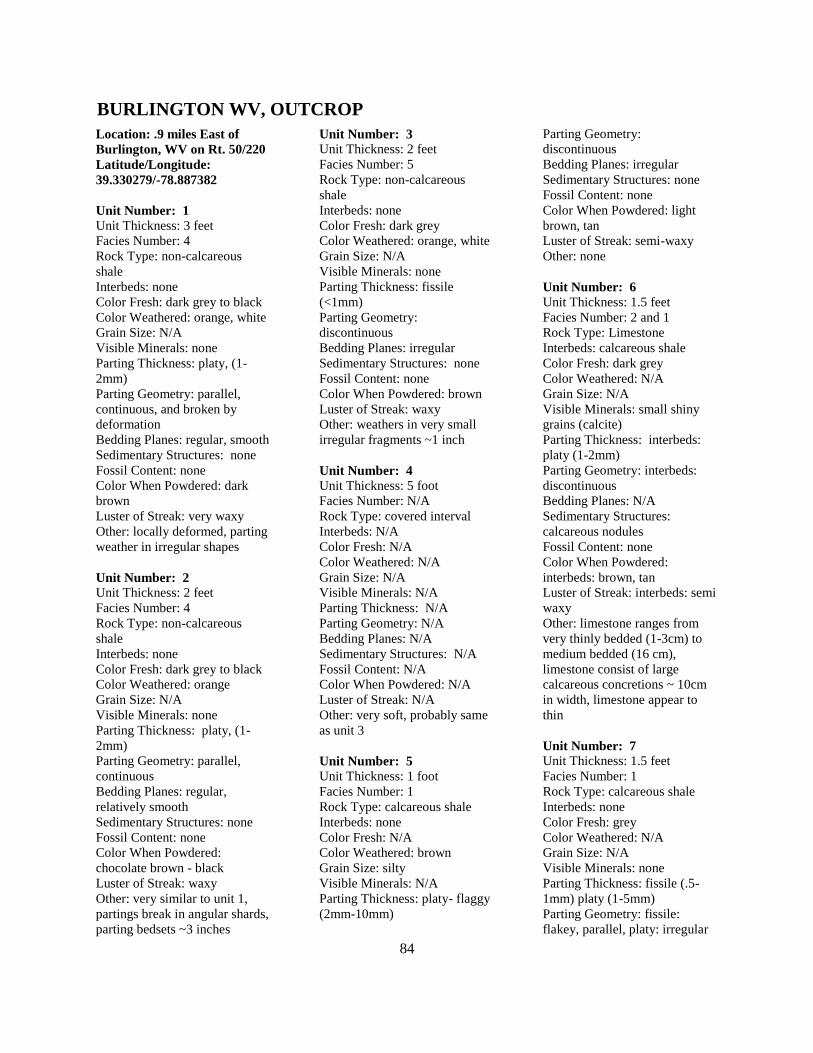
84
Location: .9 miles East of
Burlington, WV on Rt. 50/220
Latitude/Longitude:
39.330279/-78.887382
Unit Number: 1
Unit Thickness: 3 feet
Facies Number: 4
Rock Type: non-calcareous
shale
Interbeds: none
Color Fresh: dark grey to black
Color Weathered: orange, white
Grain Size: N/A
Visible Minerals: none
Parting Thickness: platy, (1-
2mm)
Parting Geometry: parallel,
continuous, and broken by
deformation
Bedding Planes: regular, smooth
Sedimentary Structures: none
Fossil Content: none
Color When Powdered: dark
brown
Luster of Streak: very waxy
Other: locally deformed, parting
weather in irregular shapes
Unit Number: 2
Unit Thickness: 2 feet
Facies Number: 4
Rock Type: non-calcareous
shale
Interbeds: none
Color Fresh: dark grey to black
Color Weathered: orange
Grain Size: N/A
Visible Minerals: none
Parting Thickness: platy, (1-
2mm)
Parting Geometry: parallel,
continuous
Bedding Planes: regular,
relatively smooth
Sedimentary Structures: none
Fossil Content: none
Color When Powdered:
chocolate brown - black
Luster of Streak: waxy
Other: very similar to unit 1,
partings break in angular shards,
parting bedsets ~3 inches
Unit Number: 3
Unit Thickness: 2 feet
Facies Number: 5
Rock Type: non-calcareous
shale
Interbeds: none
Color Fresh: dark grey
Color Weathered: orange, white
Grain Size: N/A
Visible Minerals: none
Parting Thickness: fissile
(<1mm)
Parting Geometry:
discontinuous
Bedding Planes: irregular
Sedimentary Structures: none
Fossil Content: none
Color When Powdered: brown
Luster of Streak: waxy
Other: weathers in very small
irregular fragments ~1 inch
Unit Number: 4
Unit Thickness: 5 foot
Facies Number: N/A
Rock Type: covered interval
Interbeds: N/A
Color Fresh: N/A
Color Weathered: N/A
Grain Size: N/A
Visible Minerals: N/A
Parting Thickness: N/A
Parting Geometry: N/A
Bedding Planes: N/A
Sedimentary Structures: N/A
Fossil Content: N/A
Color When Powdered: N/A
Luster of Streak: N/A
Other: very soft, probably same
as unit 3
Unit Number: 5
Unit Thickness: 1 foot
Facies Number: 1
Rock Type: calcareous shale
Interbeds: none
Color Fresh: N/A
Color Weathered: brown
Grain Size: silty
Visible Minerals: N/A
Parting Thickness: platy- flaggy
(2mm-10mm)
Parting Geometry:
discontinuous
Bedding Planes: irregular
Sedimentary Structures: none
Fossil Content: none
Color When Powdered: light
brown, tan
Luster of Streak: semi-waxy
Other: none
Unit Number: 6
Unit Thickness: 1.5 feet
Facies Number: 2 and 1
Rock Type: Limestone
Interbeds: calcareous shale
Color Fresh: dark grey
Color Weathered: N/A
Grain Size: N/A
Visible Minerals: small shiny
grains (calcite)
Parting Thickness: interbeds:
platy (1-2mm)
Parting Geometry: interbeds:
discontinuous
Bedding Planes: N/A
Sedimentary Structures:
calcareous nodules
Fossil Content: none
Color When Powdered:
interbeds: brown, tan
Luster of Streak: interbeds: semi
waxy
Other: limestone ranges from
very thinly bedded (1-3cm) to
medium bedded (16 cm),
limestone consist of large
calcareous concretions ~ 10cm
in width, limestone appear to
thin
Unit Number: 7
Unit Thickness: 1.5 feet
Facies Number: 1
Rock Type: calcareous shale
Interbeds: none
Color Fresh: grey
Color Weathered: N/A
Grain Size: N/A
Visible Minerals: none
Parting Thickness: fissile (.5-
1mm) platy (1-5mm)
Parting Geometry: fissile:
flakey, parallel, platy: irregular
BURLINGTON WV, OUTCROP
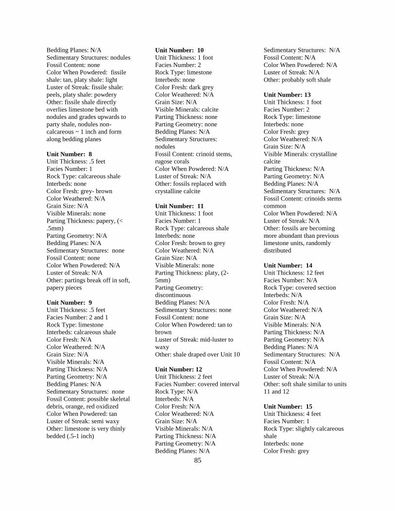
85
Bedding Planes: N/A
Sedimentary Structures: nodules
Fossil Content: none
Color When Powdered: fissile
shale: tan, platy shale: light
Luster of Streak: fissile shale:
peels, platy shale: powdery
Other: fissile shale directly
overlies limestone bed with
nodules and grades upwards to
party shale, nodules non-
calcareous ~ 1 inch and form
along bedding planes
Unit Number: 8
Unit Thickness: .5 feet
Facies Number: 1
Rock Type: calcareous shale
Interbeds: none
Color Fresh: grey- brown
Color Weathered: N/A
Grain Size: N/A
Visible Minerals: none
Parting Thickness: papery, (<
.5mm)
Parting Geometry: N/A
Bedding Planes: N/A
Sedimentary Structures: none
Fossil Content: none
Color When Powdered: N/A
Luster of Streak: N/A
Other: partings break off in soft,
papery pieces
Unit Number: 9
Unit Thickness: .5 feet
Facies Number: 2 and 1
Rock Type: limestone
Interbeds: calcareous shale
Color Fresh: N/A
Color Weathered: N/A
Grain Size: N/A
Visible Minerals: N/A
Parting Thickness: N/A
Parting Geometry: N/A
Bedding Planes: N/A
Sedimentary Structures: none
Fossil Content: possible skeletal
debris, orange, red oxidized
Color When Powdered: tan
Luster of Streak: semi waxy
Other: limestone is very thinly
bedded (.5-1 inch)
Unit Number: 10
Unit Thickness: 1 foot
Facies Number: 2
Rock Type: limestone
Interbeds: none
Color Fresh: dark grey
Color Weathered: N/A
Grain Size: N/A
Visible Minerals: calcite
Parting Thickness: none
Parting Geometry: none
Bedding Planes: N/A
Sedimentary Structures:
nodules
Fossil Content: crinoid stems,
rugose corals
Color When Powdered: N/A
Luster of Streak: N/A
Other: fossils replaced with
crystalline calcite
Unit Number: 11
Unit Thickness: 1 foot
Facies Number: 1
Rock Type: calcareous shale
Interbeds: none
Color Fresh: brown to grey
Color Weathered: N/A
Grain Size: N/A
Visible Minerals: none
Parting Thickness: platy, (2-
5mm)
Parting Geometry:
discontinuous
Bedding Planes: N/A
Sedimentary Structures: none
Fossil Content: none
Color When Powdered: tan to
brown
Luster of Streak: mid-luster to
waxy
Other: shale draped over Unit 10
Unit Number: 12
Unit Thickness: 2 feet
Facies Number: covered interval
Rock Type: N/A
Interbeds: N/A
Color Fresh: N/A
Color Weathered: N/A
Grain Size: N/A
Visible Minerals: N/A
Parting Thickness: N/A
Parting Geometry: N/A
Bedding Planes: N/A
Sedimentary Structures: N/A
Fossil Content: N/A
Color When Powdered: N/A
Luster of Streak: N/A
Other: probably soft shale
Unit Number: 13
Unit Thickness: 1 foot
Facies Number: 2
Rock Type: limestone
Interbeds: none
Color Fresh: grey
Color Weathered: N/A
Grain Size: N/A
Visible Minerals: crystalline
calcite
Parting Thickness: N/A
Parting Geometry: N/A
Bedding Planes: N/A
Sedimentary Structures: N/A
Fossil Content: crinoids stems
common
Color When Powdered: N/A
Luster of Streak: N/A
Other: fossils are becoming
more abundant than previous
limestone units, randomly
distributed
Unit Number: 14
Unit Thickness: 12 feet
Facies Number: N/A
Rock Type: covered section
Interbeds: N/A
Color Fresh: N/A
Color Weathered: N/A
Grain Size: N/A
Visible Minerals: N/A
Parting Thickness: N/A
Parting Geometry: N/A
Bedding Planes: N/A
Sedimentary Structures: N/A
Fossil Content: N/A
Color When Powdered: N/A
Luster of Streak: N/A
Other: soft shale similar to units
11 and 12
Unit Number: 15
Unit Thickness: 4 feet
Facies Number: 1
Rock Type: slightly calcareous
shale
Interbeds: none
Color Fresh: grey
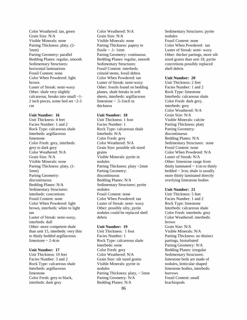
86
Color Weathered: tan, green
Grain Size: N/A
Visible Minerals: none
Parting Thickness: platy, (2-
5mm)
Parting Geometry: parallel
Bedding Planes: regular, smooth
Sedimentary Structures:
horizontal laminations
Fossil Content: none
Color When Powdered: light
brown
Luster of Streak: semi-waxy
Other: shale very slightly
calcareous, breaks into small ~1-
2 inch pieces, some bed set ~2-3
cm
Unit Number: 16
Unit Thickness: 4 feet
Facies Number: 1 and 2
Rock Type: calcareous shale
Interbeds: argillaceous
limestone
Color Fresh: grey, interbeds:
grey to dark grey
Color Weathered: N/A
Grain Size: N/A
Visible Minerals: none
Parting Thickness: platy, (1-
5mm)
Parting Geometry:
discontinuous
Bedding Planes: N/A
Sedimentary Structures:
interbeds: concretions
Fossil Content: none
Color When Powdered: light
brown, interbeds: white to light
tan
Luster of Streak: semi-waxy,
interbeds: dull
Other: more competent shale
than unit 15, interbeds: very thin
to thinly bedded argillaceous
limestone ~ 2-4cm
Unit Number: 17
Unit Thickness: 10 feet
Facies Number: 3 and 2
Rock Type: calcareous shale
Interbeds: argillaceous
limestone
Color Fresh: grey to black,
interbeds: dark grey
Color Weathered: N/A
Grain Size: N/A
Visible Minerals: none
Parting Thickness: papery to
fissile ~ .1- 1mm
Parting Geometry: continuous
Bedding Planes: regular, smooth
Sedimentary Structures:
Fossil Content: interbeds:
crinoid stems, fossil debris
Color When Powdered: tan
Luster of Streak: semi-waxy
Other: fossils found on bedding
planes, shale breaks in soft
sheets, interbeds: argillaceous
limestone ~ .5-1inch in
thickness
Unit Number: 18
Unit Thickness: 1 foot
Facies Number: 1
Rock Type: calcareous shale
Interbeds: N/A
Color Fresh: grey
Color Weathered: N/A
Grain Size: possible silt sized
grains
Visible Minerals: pyrite in
nodules
Parting Thickness: platy ~2mm
Parting Geometry:
discontinuous
Bedding Planes: N/A
Sedimentary Structures: pyrite
nodules
Fossil Content: none
Color When Powdered: tan
Luster of Streak: semi- waxy
Other: possibly silty, pyrite
nodules could be replaced shell
debris
Unit Number: 19
Unit Thickness: 1 foot
Facies Number: 1
Rock Type: calcareous shale
Interbeds: none
Color Fresh: grey
Color Weathered: N/A
Grain Size: silt sized grains
Visible Minerals: pyrite in
nodules
Parting Thickness: platy, ~ 5mm
Parting Geometry: N/A
Bedding Planes: N/A
Sedimentary Structures: pyrite
nodules
Fossil Content: none
Color When Powdered: tan
Luster of Streak: semi- waxy
Other: thicker partings, more silt
sized grains than unit 18, pyrite
concretions possibly replaced
shell debris
Unit Number: 20
Unit Thickness: 2 feet
Facies Number: 1 and 2
Rock Type: limestone
Interbeds: calcareous shale
Color Fresh: dark grey,
interbeds: grey
Color Weathered: N/A
Grain Size: N/A
Visible Minerals: calcite
Parting Thickness: platy
Parting Geometry:
discontinuous
Bedding Planes: N/A
Sedimentary Structures: none
Fossil Content: none
Color When Powdered: N/A
Luster of Streak: N/A
Other: limestone range from
thinly laminated ~ 1cm to thinly
bedded ~ 3cm; shale is usually
more thinly laminated directly
overlying limestone bodies
Unit Number: 21
Unit Thickness: 5 feet
Facies Number: 1 and 2
Rock Type: limestone
Interbeds: calcareous shale
Color Fresh: interbeds: grey
Color Weathered: interbeds:
brown
Grain Size: N/A
Visible Minerals: N/A
Parting Thickness: no distinct
partings, bioturbated
Parting Geometry: N/A
Bedding Planes: irregular
Sedimentary Structures:
limestone beds are made of
nodules, lenticular shaped
limestone bodies, interbeds:
burrows
Fossil Content: small
brachiopods
87
Color When Powdered:
interbeds: brown
Luster of Streak: interbeds:
waxy
Other: limestone beds are much
larger than in Unit 20 ~.8-1.5
feet, interbeds: calcareous shale
also contains more carbonate
rich beds ~ 2- 3cm, burrows
filled with lighter color mud
from above or below
Unit Number: 22
Unit Thickness: 1 foot
Facies Number: 1
Rock Type: calcareous shale
Interbeds: none
Color Fresh: grey
Color Weathered: brown, white
Grain Size: N/A
Visible Minerals: none
Parting Thickness: slabby ~ 10
mm
Parting Geometry:
discontinuous
Bedding Planes: irregular
Sedimentary Structures:
flattened, calcareous, and oblong
concretions, burrows
Fossil Content: none
Color When Powdered: brown
Luster of Streak: waxy
Other: concretion has especially
high specific gravity for size,
shale is only slightly calcareous,
and shale contains red/orange
oxidized burrows
Unit Number: 23
Unit Thickness: 9 feet
Facies Number: 1 and 2
Rock Type: calcareous shale
Interbeds: limestone
Color Fresh: grey to dark grey
interbeds: very dark grey
Color Weathered: N/A
Grain Size: N/A
Visible Minerals: interbeds:
calcite
Parting Thickness: papery to
platy
Parting Geometry:
discontinuous
Bedding Planes: irregular
Sedimentary Structures:
bioturbated
Fossil Content: none
Color When Powdered: tan
Luster of Streak: semi- waxy
Other: interbeds: limestone is
very thinly bedded ~2-3cm, red
to orange oxidized burrows in
shale, shale begins to get darker
towards Unit 24
Unit Number: 24
Unit Thickness: 10 feet
Facies Number: 2
Rock Type: argillaceous
limestone
Interbeds: none
Color Fresh: black
Color Weathered: N/A
Grain Size: N/A
Visible Minerals: N/A
Parting Thickness: N/A
Parting Geometry: N/A
Bedding Planes: irregular
Sedimentary Structures: siderite
nodules, possible oxidized
burrows
Fossil Content: bivalve,
styliolinids
Color When Powdered: brown
Luster of Streak: dull
Other: limestone is very thinly
bedded, nodules very heavy,
slightly calcareous, oval shaped
range from .4-.7 feet in size
Unit Number: 25
Unit Thickness: 2 feet
Facies Number: 1
Rock Type: calcareous shale
Interbeds: none
Color Fresh: brown
Color Weathered: N/A
Grain Size: N/A
Visible Minerals: N/A
Parting Thickness: N/A
Parting Geometry: N/A
Bedding Planes: N/A
Sedimentary Structures:
calcareous nodules
Fossil Content: some shell
debris
Color When Powdered: N/A
Luster of Streak: N/A
Other: partially covered
88
Location: 3 miles Northeast of
Springfield, WV on Co. Rt.1
Latitude/
Longitude:39.483756/-
78.664749
Unit Number: 1
Unit Thickness: 92 cm
Facies Number:1
Rock Type: calcareous shale
Interbeds: none
Color Fresh: grey
Color Weathered: brown
Grain Size: N/A
Visible Minerals: none
Parting Thickness: thick
partings
Parting Geometry: N/A
Bedding Planes: N/A
Sedimentary Structures: none
Fossil Content: none
Color When Powdered: N/A
Luster of Streak: N/A
Other: first bed along railroad
tracks
Unit Number: 2
Unit Thickness: 45 cm
Facies Number: 5
Rock Type: non-calcareous
shale
Interbeds: none
Color Fresh: dark grey
Color Weathered: N/A
Grain Size: N/A
Visible Minerals: none
Parting Thickness: N/A
Parting Geometry: N/A
Bedding Planes: N/A
Sedimentary Structures:
laminated
Fossil Content: styliolinid,
possible small ammonoid
Color When Powdered: N/A
Luster of Streak: N/A
Other: contact with underlying
unit appears to be gradational
Unit Number: 3
Unit Thickness: 16 cm
Facies Number: 1
Rock Type: calcareous shale
(silty)
Interbeds: none
Color Fresh: grey
Color Weathered: brown
Grain Size: possibly silt sized
grains
Visible Minerals: none
Parting Thickness: N/A
Parting Geometry: N/A
Bedding Planes: N/A
Sedimentary Structures:
extensively burrowed
Fossil Content: none
Color When Powdered: N/A
Luster of Streak: N/A
Other: contact with underlying
unit appears to be gradational
Unit Number: 4
Unit Thickness: 130 cm
Facies Number: 2 and 1
Rock Type: limestone,
grainstone
Interbeds: calcareous shale
Color Fresh: black to dark grey
Color Weathered: N/A
Grain Size: pebble like grains in
base of limestone bed
Visible Minerals: none
Parting Thickness: N/A
Parting Geometry: N/A
Bedding Planes: N/A
Sedimentary Structures: none
Fossil Content: ambeocela,
brachiopods
Color When Powdered: N/A
Luster of Streak: N/A
Other: limestone ~ 10-22cm
with thin interbeds of shale,
three limestone beds: (19cm,
14cm, 8cm), middle limestone
bed contains unknown brown
stick like features
Unit Number: 5
Unit Thickness: 100 cm
Facies Number: 1 and 2
Rock Type: Covered section,
limestone
Interbeds: calcareous shale
Color Fresh: N/A
Color Weathered: N/A
Grain Size: N/A
Visible Minerals: N/A
Parting Thickness: N/A
Parting Geometry: N/A
Bedding Planes: N/A
Sedimentary Structures: N/A
Fossil Content: N/A
Color When Powdered: N/A
Luster of Streak: N/A
Other: N/A
Unit Number: 6
Unit Thickness: 70 cm
Facies Number: 2
Rock Type: limestone, three
beds
Interbeds: none
Color Fresh: N/A
Color Weathered: N/A
Grain Size: N/A
Visible Minerals: calcite
Parting Thickness: N/A
Parting Geometry: N/A
Bedding Planes: N/A
Sedimentary Structures:
abundant siderite molds
Fossil Content: re-crystallized
cephalopod, calcite-filled
structures, shell debris
Color When Powdered: N/A
Luster of Streak: N/A
Other: limestone bodies are
possibly wedge shaped, two
generations of vertical fractures
backfilled with calcite
Unit Number: 7
Unit Thickness: 303 cm
Facies Number: 5
Rock Type: non-calcareous
shale, mostly covered
Interbeds: none
Color Fresh: grey
Color Weathered: brown
Grain Size: N/A
Visible Minerals: N/A
Parting Thickness: N/A
Parting Geometry: N/A
Bedding Planes: N/A
Sedimentary Structures:
laminated
Fossil Content: none
Color When Powdered: N/A
SPRINGFIELD WV, OUTCROP
89
Luster of Streak: N/A
Other: low density, platy
Unit Number: 8 Unit Thickness: 60 cm
Facies Number: 4
Rock Type: non-calcareous
Interbeds: none
Color Fresh: black
Color Weathered: N/A
Grain Size: N/A
Visible Minerals: none
Parting Thickness: N/A
Parting Geometry: N/A
Bedding Planes: N/A
Sedimentary Structures:
laminated, siderite concretions
Fossil Content: none
Color When Powdered: N/A
Luster of Streak: N/A
Other: shiny and deformed
around siderite concretions
Unit Number: 9
Unit Thickness: 400 cm
Facies Number: 4
Rock Type: non-calcareous
Interbeds: none
Color Fresh: black
Color Weathered: N/A
Grain Size: N/A
Visible Minerals: none
Parting Thickness: platy, 1-
4mm
Parting Geometry: N/A
Bedding Planes: N/A
Sedimentary Structures:
laminated
Fossil Content: none
Color When Powdered: N/A
Luster of Streak: N/A
Other: minor deformation,
possible limestone lense one
meter above this unit
90
Location: 1.4 miles Southwest
of Green Spring, WV on Co.
Rt. 1
Latitude/Longitude:
39.517384/-78.632605
Unit Number: 1
Unit Thickness: 10.25 feet
Facies Number: 5
Rock Type: non-calcareous
shale
Interbeds: none
Color Fresh: medium to dark
grey
Color Weathered: orange,
maroon
Grain Size: N/A
Visible Minerals: none
Parting Thickness: platy to
slabby, 2-10mm
Parting Geometry:
discontinuous
Bedding Planes: N/A
Sedimentary Structures: bedded
nodules, horizontal laminea
Fossil Content: part of unknown
crustacean (Nektonic).
Color When Powdered: light tan
Luster of Streak: dull
Other: black and red weathering
around nodules, oblong shaped
~2 inches-1foot
Unit Number: 2
Unit Thickness: 1.08 feet
Facies Number: 5
Rock Type: non-calcareous
shale
Interbeds: none
Color Fresh: dark grey
Color Weathered: yellow, red
Grain Size: N/A
Visible Minerals: none
Parting Thickness: platy, (2-
3mm)
Parting Geometry: non- parallel,
discontinuous
Bedding Planes: irregular,
bumpy
Sedimentary Structures:
horizontal bioturbation
Fossil Content: none
Color When Powdered: tan
Luster of Streak: dull
Other: Iridescent stains and
white crystal precipitate on
bedding surfaces.
Unit Number: 3
Unit Thickness: 3.42 feet
Facies Number: 5
Rock Type: non- calcareous
shale
Interbeds: none
Color Fresh: light-dark grey
Color Weathered: orange, red
Grain Size: N/A
Visible Minerals: none
Parting Thickness: platy, ~1mm
Parting Geometry:
discontinuous
Bedding Planes: N/A
Sedimentary Structures:
nodules
Fossil Content: None
Color When Powdered: light
grey
Luster of Streak: intermediate
luster
Other: nodules randomly
distributed, shale beds draped
overtop
Unit Number: 4
Unit Thickness: 1.42 feet
Facies Number: 5
Rock Type: non-calcareous
shale
Interbeds: none
Color Fresh: light- dark grey
Color Weathered: orange, red,
white
Grain Size: N/A
Visible Minerals: unknown silt
sized grains
Parting Thickness: platy to
flaggy (1mm-5mm)
Parting Geometry:
discontinuous
Bedding Planes: N/A
Sedimentary Structures: none
Fossil Content: none
Color When Powdered: tan
Luster of Streak: dull
Other: grey shale is silty,
distinct contact between facies 3
and 4
Unit Number: 5
Unit Thickness: 3 feet
Facies Number: 5 and 4
Rock Type: non-calcareous
shale
Interbeds: none
Color Fresh: grey to black
Color Weathered: white, grey
Grain Size: N/A
Visible Minerals: none
Parting Thickness: platy, (1-
5mm)
Parting Geometry:
discontinuous
Bedding Planes: N/A
Sedimentary Structures: none
Fossil Content: none
Color When Powdered: tan-
grey
Luster of Streak: semi waxy,
mid luster
Other: very similar to Unit 4,
weathers into irregular,
discontinuous chips
Unit Number: 6
Unit Thickness: 3 feet
Facies Number: 5
Rock Type: non-calcareous
shale
Interbeds: bedded siderite
Color Fresh: dark grey
Color Weathered: orange, red
Grain Size: N/A
Visible Minerals: none
Parting Thickness: platy ~
5mm, interbeds: < 5mm
Parting Geometry: sheet like,
Bedding Planes: irregular
Sedimentary Structures: 7ft long
bedded siderite nodules
Fossil Content: none
Color When Powdered: light
Luster of Streak: dull, interbeds:
semi-waxy
Other: lense shaped interbeds
range from 1- 5 inches
GREENSPRING WV, OUTCROP
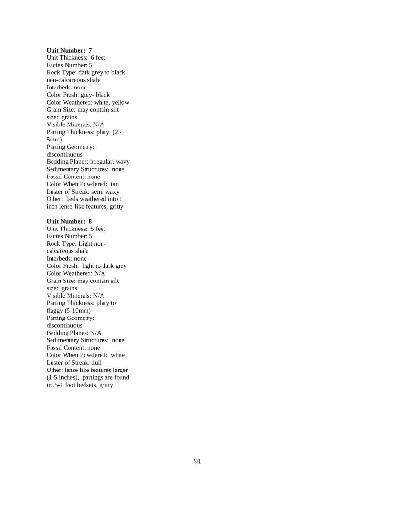
91
Unit Number: 7
Unit Thickness: 6 feet
Facies Number: 5
Rock Type: dark grey to black
non-calcareous shale
Interbeds: none
Color Fresh: grey- black
Color Weathered: white, yellow
Grain Size: may contain silt
sized grains
Visible Minerals: N/A
Parting Thickness: platy, (2 -
5mm)
Parting Geometry:
discontinuous
Bedding Planes: irregular, wavy
Sedimentary Structures: none
Fossil Content: none
Color When Powdered: tan
Luster of Streak: semi waxy
Other: beds weathered into 1
inch lense-like features, gritty
Unit Number: 8
Unit Thickness: 5 feet
Facies Number: 5
Rock Type: Light non-
calcareous shale
Interbeds: none
Color Fresh: light to dark grey
Color Weathered: N/A
Grain Size: may contain silt
sized grains
Visible Minerals: N/A
Parting Thickness: platy to
flaggy (5-10mm)
Parting Geometry:
discontinuous
Bedding Planes: N/A
Sedimentary Structures: none
Fossil Content: none
Color When Powdered: white
Luster of Streak: dull
Other: lense like features larger
(1-5 inches), .partings are found
in .5-1 foot bedsets, gritty
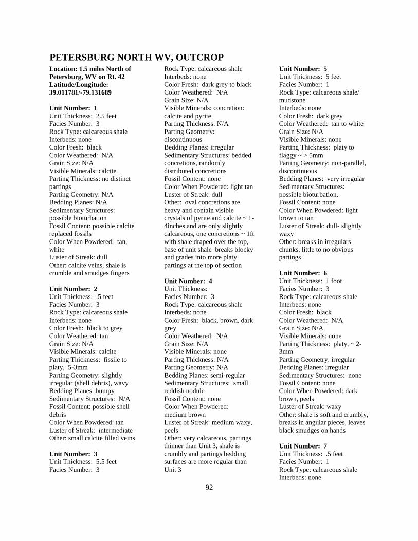
92
Location: 1.5 miles North of
Petersburg, WV on Rt. 42
Latitude/Longitude:
39.011781/-79.131689
Unit Number: 1
Unit Thickness: 2.5 feet
Facies Number: 3
Rock Type: calcareous shale
Interbeds: none
Color Fresh: black
Color Weathered: N/A
Grain Size: N/A
Visible Minerals: calcite
Parting Thickness: no distinct
partings
Parting Geometry: N/A
Bedding Planes: N/A
Sedimentary Structures:
possible bioturbation
Fossil Content: possible calcite
replaced fossils
Color When Powdered: tan,
white
Luster of Streak: dull
Other: calcite veins, shale is
crumble and smudges fingers
Unit Number: 2
Unit Thickness: .5 feet
Facies Number: 3
Rock Type: calcareous shale
Interbeds: none
Color Fresh: black to grey
Color Weathered: tan
Grain Size: N/A
Visible Minerals: calcite
Parting Thickness: fissile to
platy, .5-3mm
Parting Geometry: slightly
irregular (shell debris), wavy
Bedding Planes: bumpy
Sedimentary Structures: N/A
Fossil Content: possible shell
debris
Color When Powdered: tan
Luster of Streak: intermediate
Other: small calcite filled veins
Unit Number: 3
Unit Thickness: 5.5 feet
Facies Number: 3
Rock Type: calcareous shale
Interbeds: none
Color Fresh: dark grey to black
Color Weathered: N/A
Grain Size: N/A
Visible Minerals: concretion:
calcite and pyrite
Parting Thickness: N/A
Parting Geometry:
discontinuous
Bedding Planes: irregular
Sedimentary Structures: bedded
concretions, randomly
distributed concretions
Fossil Content: none
Color When Powdered: light tan
Luster of Streak: dull
Other: oval concretions are
heavy and contain visible
crystals of pyrite and calcite ~ 1-
4inches and are only slightly
calcareous, one concretions ~ 1ft
with shale draped over the top,
base of unit shale breaks blocky
and grades into more platy
partings at the top of section
Unit Number: 4
Unit Thickness:
Facies Number: 3
Rock Type: calcareous shale
Interbeds: none
Color Fresh: black, brown, dark
grey
Color Weathered: N/A
Grain Size: N/A
Visible Minerals: none
Parting Thickness: N/A
Parting Geometry: N/A
Bedding Planes: semi-regular
Sedimentary Structures: small
reddish nodule
Fossil Content: none
Color When Powdered:
medium brown
Luster of Streak: medium waxy,
peels
Other: very calcareous, partings
thinner than Unit 3, shale is
crumbly and partings bedding
surfaces are more regular than
Unit 3
Unit Number: 5
Unit Thickness: 5 feet
Facies Number: 1
Rock Type: calcareous shale/
mudstone
Interbeds: none
Color Fresh: dark grey
Color Weathered: tan to white
Grain Size: N/A
Visible Minerals: none
Parting Thickness: platy to
flaggy ~ > 5mm
Parting Geometry: non-parallel,
discontinuous
Bedding Planes: very irregular
Sedimentary Structures:
possible bioturbation,
Fossil Content: none
Color When Powdered: light
brown to tan
Luster of Streak: dull- slightly
waxy
Other: breaks in irregulars
chunks, little to no obvious
partings
Unit Number: 6
Unit Thickness: 1 foot
Facies Number: 3
Rock Type: calcareous shale
Interbeds: none
Color Fresh: black
Color Weathered: N/A
Grain Size: N/A
Visible Minerals: none
Parting Thickness: platy, ~ 2-
3mm
Parting Geometry: irregular
Bedding Planes: irregular
Sedimentary Structures: none
Fossil Content: none
Color When Powdered: dark
brown, peels
Luster of Streak: waxy
Other: shale is soft and crumbly,
breaks in angular pieces, leaves
black smudges on hands
Unit Number: 7
Unit Thickness: .5 feet
Facies Number: 1
Rock Type: calcareous shale
Interbeds: none
PETERSBURG NORTH WV, OUTCROP
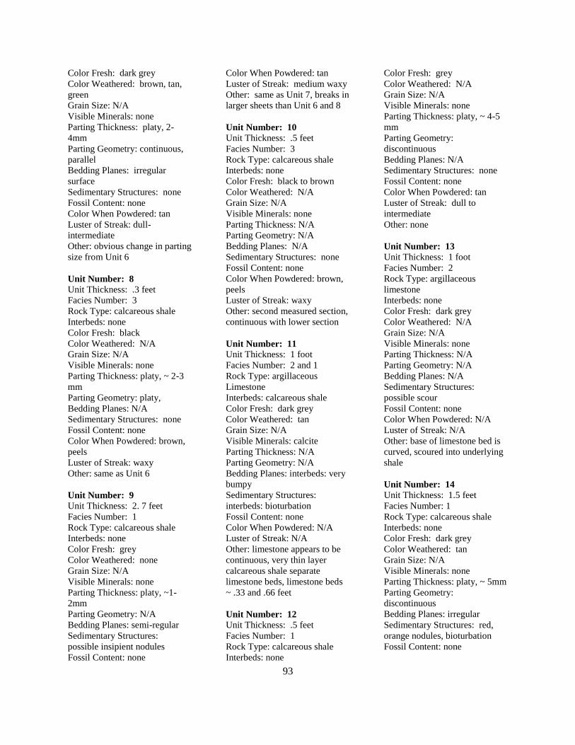
93
Color Fresh: dark grey
Color Weathered: brown, tan,
green
Grain Size: N/A
Visible Minerals: none
Parting Thickness: platy, 2-
4mm
Parting Geometry: continuous,
parallel
Bedding Planes: irregular
surface
Sedimentary Structures: none
Fossil Content: none
Color When Powdered: tan
Luster of Streak: dull-
intermediate
Other: obvious change in parting
size from Unit 6
Unit Number: 8
Unit Thickness: .3 feet
Facies Number: 3
Rock Type: calcareous shale
Interbeds: none
Color Fresh: black
Color Weathered: N/A
Grain Size: N/A
Visible Minerals: none
Parting Thickness: platy, ~ 2-3
mm
Parting Geometry: platy,
Bedding Planes: N/A
Sedimentary Structures: none
Fossil Content: none
Color When Powdered: brown,
peels
Luster of Streak: waxy
Other: same as Unit 6
Unit Number: 9
Unit Thickness: 2. 7 feet
Facies Number: 1
Rock Type: calcareous shale
Interbeds: none
Color Fresh: grey
Color Weathered: none
Grain Size: N/A
Visible Minerals: none
Parting Thickness: platy, ~1-
2mm
Parting Geometry: N/A
Bedding Planes: semi-regular
Sedimentary Structures:
possible insipient nodules
Fossil Content: none
Color When Powdered: tan
Luster of Streak: medium waxy
Other: same as Unit 7, breaks in
larger sheets than Unit 6 and 8
Unit Number: 10
Unit Thickness: .5 feet
Facies Number: 3
Rock Type: calcareous shale
Interbeds: none
Color Fresh: black to brown
Color Weathered: N/A
Grain Size: N/A
Visible Minerals: none
Parting Thickness: N/A
Parting Geometry: N/A
Bedding Planes: N/A
Sedimentary Structures: none
Fossil Content: none
Color When Powdered: brown,
peels
Luster of Streak: waxy
Other: second measured section,
continuous with lower section
Unit Number: 11
Unit Thickness: 1 foot
Facies Number: 2 and 1
Rock Type: argillaceous
Limestone
Interbeds: calcareous shale
Color Fresh: dark grey
Color Weathered: tan
Grain Size: N/A
Visible Minerals: calcite
Parting Thickness: N/A
Parting Geometry: N/A
Bedding Planes: interbeds: very
bumpy
Sedimentary Structures:
interbeds: bioturbation
Fossil Content: none
Color When Powdered: N/A
Luster of Streak: N/A
Other: limestone appears to be
continuous, very thin layer
calcareous shale separate
limestone beds, limestone beds
~ .33 and .66 feet
Unit Number: 12
Unit Thickness: .5 feet
Facies Number: 1
Rock Type: calcareous shale
Interbeds: none
Color Fresh: grey
Color Weathered: N/A
Grain Size: N/A
Visible Minerals: none
Parting Thickness: platy, ~ 4-5
mm
Parting Geometry:
discontinuous
Bedding Planes: N/A
Sedimentary Structures: none
Fossil Content: none
Color When Powdered: tan
Luster of Streak: dull to
intermediate
Other: none
Unit Number: 13
Unit Thickness: 1 foot
Facies Number: 2
Rock Type: argillaceous
limestone
Interbeds: none
Color Fresh: dark grey
Color Weathered: N/A
Grain Size: N/A
Visible Minerals: none
Parting Thickness: N/A
Parting Geometry: N/A
Bedding Planes: N/A
Sedimentary Structures:
possible scour
Fossil Content: none
Color When Powdered: N/A
Luster of Streak: N/A
Other: base of limestone bed is
curved, scoured into underlying
shale
Unit Number: 14
Unit Thickness: 1.5 feet
Facies Number: 1
Rock Type: calcareous shale
Interbeds: none
Color Fresh: dark grey
Color Weathered: tan
Grain Size: N/A
Visible Minerals: none
Parting Thickness: platy, ~ 5mm
Parting Geometry:
discontinuous
Bedding Planes: irregular
Sedimentary Structures: red,
orange nodules, bioturbation
Fossil Content: none
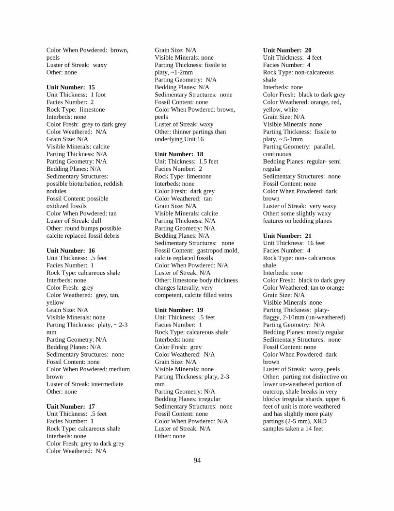
94
Color When Powdered: brown,
peels
Luster of Streak: waxy
Other: none
Unit Number: 15
Unit Thickness: 1 foot
Facies Number: 2
Rock Type: limestone
Interbeds: none
Color Fresh: grey to dark grey
Color Weathered: N/A
Grain Size: N/A
Visible Minerals: calcite
Parting Thickness: N/A
Parting Geometry: N/A
Bedding Planes: N/A
Sedimentary Structures:
possible bioturbation, reddish
nodules
Fossil Content: possible
oxidized fossils
Color When Powdered: tan
Luster of Streak: dull
Other: round bumps possible
calcite replaced fossil debris
Unit Number: 16
Unit Thickness: .5 feet
Facies Number: 1
Rock Type: calcareous shale
Interbeds: none
Color Fresh: grey
Color Weathered: grey, tan,
yellow
Grain Size: N/A
Visible Minerals: none
Parting Thickness: platy, ~ 2-3
mm
Parting Geometry: N/A
Bedding Planes: N/A
Sedimentary Structures: none
Fossil Content: none
Color When Powdered: medium
brown
Luster of Streak: intermediate
Other: none
Unit Number: 17
Unit Thickness: .5 feet
Facies Number: 1
Rock Type: calcareous shale
Interbeds: none
Color Fresh: grey to dark grey
Color Weathered: N/A
Grain Size: N/A
Visible Minerals: none
Parting Thickness: fissile to
platy, ~1-2mm
Parting Geometry: N/A
Bedding Planes: N/A
Sedimentary Structures: none
Fossil Content: none
Color When Powdered: brown,
peels
Luster of Streak: waxy
Other: thinner partings than
underlying Unit 16
Unit Number: 18
Unit Thickness: 1.5 feet
Facies Number: 2
Rock Type: limestone
Interbeds: none
Color Fresh: dark grey
Color Weathered: tan
Grain Size: N/A
Visible Minerals: calcite
Parting Thickness: N/A
Parting Geometry: N/A
Bedding Planes: N/A
Sedimentary Structures: none
Fossil Content: gastropod mold,
calcite replaced fossils
Color When Powdered: N/A
Luster of Streak: N/A
Other: limestone body thickness
changes laterally, very
competent, calcite filled veins
Unit Number: 19
Unit Thickness: .5 feet
Facies Number: 1
Rock Type: calcareous shale
Interbeds: none
Color Fresh: grey
Color Weathered: N/A
Grain Size: N/A
Visible Minerals: none
Parting Thickness: platy, 2-3
mm
Parting Geometry: N/A
Bedding Planes: irregular
Sedimentary Structures: none
Fossil Content: none
Color When Powdered: N/A
Luster of Streak: N/A
Other: none
Unit Number: 20
Unit Thickness: 4 feet
Facies Number: 4
Rock Type: non-calcareous
shale
Interbeds: none
Color Fresh: black to dark grey
Color Weathered: orange, red,
yellow, white
Grain Size: N/A
Visible Minerals: none
Parting Thickness: fissile to
platy, ~.5-1mm
Parting Geometry: parallel,
continuous
Bedding Planes: regular- semi
regular
Sedimentary Structures: none
Fossil Content: none
Color When Powdered: dark
brown
Luster of Streak: very waxy
Other: some slightly waxy
features on bedding planes
Unit Number: 21
Unit Thickness: 16 feet
Facies Number: 4
Rock Type: non- calcareous
shale
Interbeds: none
Color Fresh: black to dark grey
Color Weathered: tan to orange
Grain Size: N/A
Visible Minerals: none
Parting Thickness: platy-
flaggy, 2-10mm (un-weathered)
Parting Geometry: N/A
Bedding Planes: mostly regular
Sedimentary Structures: none
Fossil Content: none
Color When Powdered: dark
brown
Luster of Streak: waxy, peels
Other: parting not distinctive on
lower un-weathered portion of
outcrop, shale breaks in very
blocky irregular shards, upper 6
feet of unit is more weathered
and has slightly more platy
partings (2-5 mm), XRD
samples taken a 14 feet
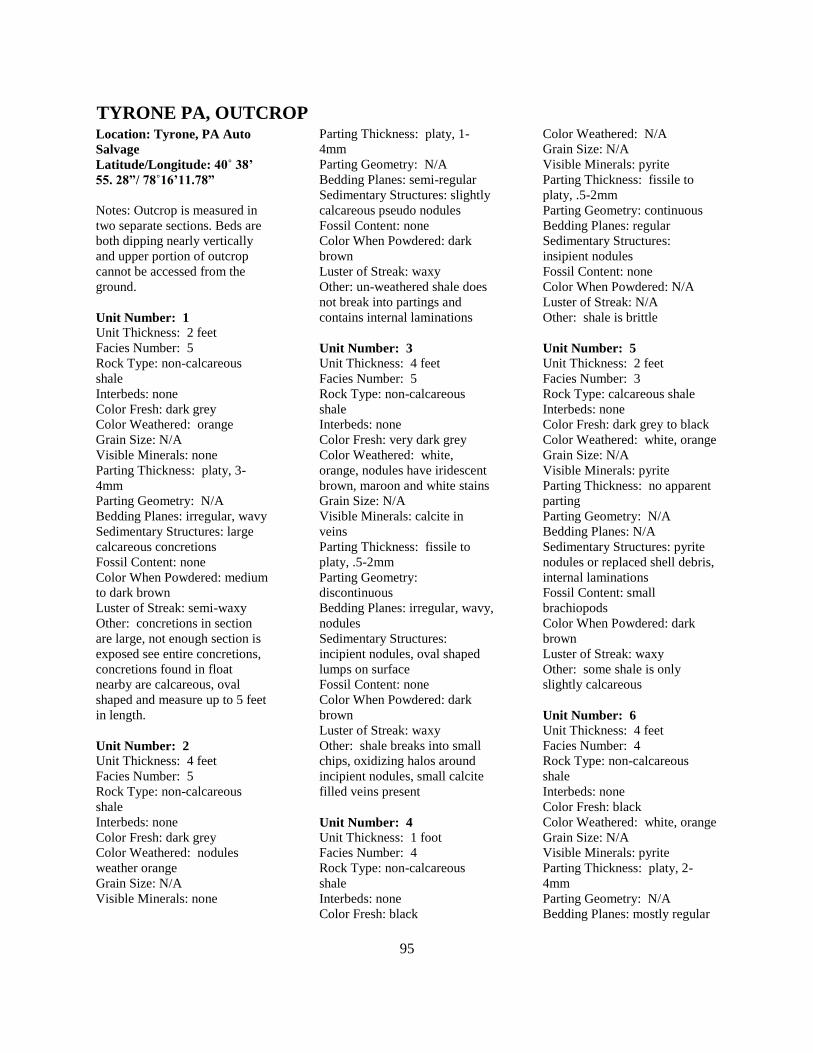
95
Location: Tyrone, PA Auto
Salvage
Latitude/Longitude: 40˚ 38’
55. 28”/ 78˚16’11.78”
Notes: Outcrop is measured in
two separate sections. Beds are
both dipping nearly vertically
and upper portion of outcrop
cannot be accessed from the
ground.
Unit Number: 1
Unit Thickness: 2 feet
Facies Number: 5
Rock Type: non-calcareous
shale
Interbeds: none
Color Fresh: dark grey
Color Weathered: orange
Grain Size: N/A
Visible Minerals: none
Parting Thickness: platy, 3-
4mm
Parting Geometry: N/A
Bedding Planes: irregular, wavy
Sedimentary Structures: large
calcareous concretions
Fossil Content: none
Color When Powdered: medium
to dark brown
Luster of Streak: semi-waxy
Other: concretions in section
are large, not enough section is
exposed see entire concretions,
concretions found in float
nearby are calcareous, oval
shaped and measure up to 5 feet
in length.
Unit Number: 2
Unit Thickness: 4 feet
Facies Number: 5
Rock Type: non-calcareous
shale
Interbeds: none
Color Fresh: dark grey
Color Weathered: nodules
weather orange
Grain Size: N/A
Visible Minerals: none
Parting Thickness: platy, 1-
4mm
Parting Geometry: N/A
Bedding Planes: semi-regular
Sedimentary Structures: slightly
calcareous pseudo nodules
Fossil Content: none
Color When Powdered: dark
brown
Luster of Streak: waxy
Other: un-weathered shale does
not break into partings and
contains internal laminations
Unit Number: 3
Unit Thickness: 4 feet
Facies Number: 5
Rock Type: non-calcareous
shale
Interbeds: none
Color Fresh: very dark grey
Color Weathered: white,
orange, nodules have iridescent
brown, maroon and white stains
Grain Size: N/A
Visible Minerals: calcite in
veins
Parting Thickness: fissile to
platy, .5-2mm
Parting Geometry:
discontinuous
Bedding Planes: irregular, wavy,
nodules
Sedimentary Structures:
incipient nodules, oval shaped
lumps on surface
Fossil Content: none
Color When Powdered: dark
brown
Luster of Streak: waxy
Other: shale breaks into small
chips, oxidizing halos around
incipient nodules, small calcite
filled veins present
Unit Number: 4
Unit Thickness: 1 foot
Facies Number: 4
Rock Type: non-calcareous
shale
Interbeds: none
Color Fresh: black
Color Weathered: N/A
Grain Size: N/A
Visible Minerals: pyrite
Parting Thickness: fissile to
platy, .5-2mm
Parting Geometry: continuous
Bedding Planes: regular
Sedimentary Structures:
insipient nodules
Fossil Content: none
Color When Powdered: N/A
Luster of Streak: N/A
Other: shale is brittle
Unit Number: 5
Unit Thickness: 2 feet
Facies Number: 3
Rock Type: calcareous shale
Interbeds: none
Color Fresh: dark grey to black
Color Weathered: white, orange
Grain Size: N/A
Visible Minerals: pyrite
Parting Thickness: no apparent
parting
Parting Geometry: N/A
Bedding Planes: N/A
Sedimentary Structures: pyrite
nodules or replaced shell debris,
internal laminations
Fossil Content: small
brachiopods
Color When Powdered: dark
brown
Luster of Streak: waxy
Other: some shale is only
slightly calcareous
Unit Number: 6
Unit Thickness: 4 feet
Facies Number: 4
Rock Type: non-calcareous
shale
Interbeds: none
Color Fresh: black
Color Weathered: white, orange
Grain Size: N/A
Visible Minerals: pyrite
Parting Thickness: platy, 2-
4mm
Parting Geometry: N/A
Bedding Planes: mostly regular
TYRONE PA, OUTCROP
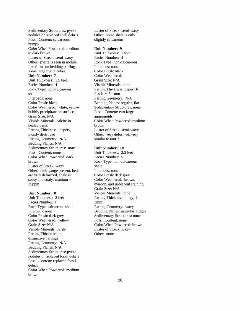
96
Sedimentary Structures: pyrite
nodules or replaced shell debris
Fossil Content: calcareous
bumps
Color When Powdered: medium
to dark brown
Luster of Streak: semi-waxy
Other: pyrite is seen in nodule
like forms on bedding partings,
some large pyrite cubes
Unit Number: 7 Unit Thickness: 1.5 feet
Facies Number: 4
Rock Type: non-calcareous
shale
Interbeds: none
Color Fresh: black
Color Weathered: white, yellow
bubbly precipitate on surface
Grain Size: N/A
Visible Minerals: calcite in
healed veins
Parting Thickness: papery,
mostly destroyed
Parting Geometry: N/A
Bedding Planes: N/A
Sedimentary Structures: none
Fossil Content: none
Color When Powdered: dark
brown
Luster of Streak: waxy
Other: fault gauge present, beds
are very deformed, shale is
sooty and coaly, uranium ~
25ppm
Unit Number: 8
Unit Thickness: 2 feet
Facies Number: 3
Rock Type: calcareous shale
Interbeds: none
Color Fresh: dark grey
Color Weathered: yellow
Grain Size: N/A
Visible Minerals: pyrite
Parting Thickness: no
distinctive partings
Parting Geometry: N/A
Bedding Planes: N/A
Sedimentary Structures: pyrite
nodules or replaced fossil debris
Fossil Content: replaced fossil
debris
Color When Powdered: medium
brown
Luster of Streak: semi-waxy
Other: some shale is only
slightly calcareous
Unit Number: 9
Unit Thickness: 1 foot
Facies Number: 4
Rock Type: non-calcareous
Interbeds: none
Color Fresh: black
Color Weathered:
Grain Size: N/A
Visible Minerals: none
Parting Thickness: papery to
fissile ~ .5-1mm
Parting Geometry: N/A
Bedding Planes: regular, flat
Sedimentary Structures: none
Fossil Content: two large
ammonoids
Color When Powdered: medium
brown
Luster of Streak: semi-waxy
Other: very deformed, very
similar to unit 7
Unit Number: 10
Unit Thickness: 2.5 feet
Facies Number: 5
Rock Type: non-calcareous
shale
Interbeds: none
Color Fresh: dark grey
Color Weathered: brown,
maroon, and iridescent staining
Grain Size: N/A
Visible Minerals: none
Parting Thickness: platy, 1-
3mm
Parting Geometry: wavy
Bedding Planes: irregular, ridges
Sedimentary Structures: none
Fossil Content: none
Color When Powdered: brown
Luster of Streak: waxy
Other: none
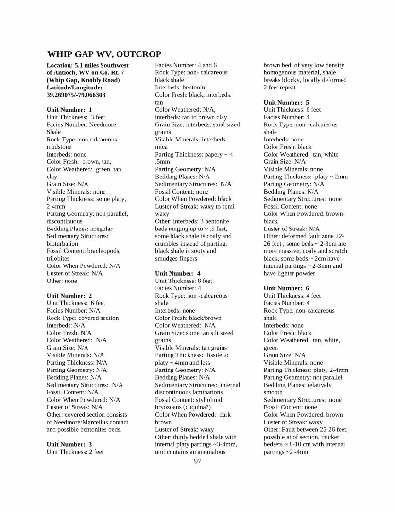
97
Location: 5.1 miles Southwest
of Antioch, WV on Co. Rt. 7
(Whip Gap, Knobly Road)
Latitude/Longitude:
39.269075/-79.066308
Unit Number: 1
Unit Thickness: 3 feet
Facies Number: Needmore
Shale
Rock Type: non calcareous
mudstone
Interbeds: none
Color Fresh: brown, tan,
Color Weathered: green, tan
clay
Grain Size: N/A
Visible Minerals: none
Parting Thickness: some platy,
2-4mm
Parting Geometry: non parallel,
discontinuous
Bedding Planes: irregular
Sedimentary Structures:
bioturbation
Fossil Content: brachiopods,
trilobites
Color When Powdered: N/A
Luster of Streak: N/A
Other: none
Unit Number: 2
Unit Thickness: 6 feet
Facies Number: N/A
Rock Type: covered section
Interbeds: N/A
Color Fresh: N/A
Color Weathered: N/A
Grain Size: N/A
Visible Minerals: N/A
Parting Thickness: N/A
Parting Geometry: N/A
Bedding Planes: N/A
Sedimentary Structures: N/A
Fossil Content: N/A
Color When Powdered: N/A
Luster of Streak: N/A
Other: covered section consists
of Needmore/Marcellus contact
and possible bentonites beds.
Unit Number: 3
Unit Thickness: 2 feet
Facies Number: 4 and 6
Rock Type: non- calcareous
black shale
Interbeds: bentonite
Color Fresh: black, interbeds:
tan
Color Weathered: N/A,
interbeds: tan to brown clay
Grain Size: interbeds: sand sized
grains
Visible Minerals: interbeds:
mica
Parting Thickness: papery ~ <
.5mm
Parting Geometry: N/A
Bedding Planes: N/A
Sedimentary Structures: N/A
Fossil Content: none
Color When Powdered: black
Luster of Streak: waxy to semi-
waxy
Other: interbeds: 3 bentonite
beds ranging up to ~ .5 feet,
some black shale is coaly and
crumbles instead of parting,
black shale is sooty and
smudges fingers
Unit Number: 4
Unit Thickness: 8 feet
Facies Number: 4
Rock Type: non -calcareous
shale
Interbeds: none
Color Fresh: black/brown
Color Weathered: N/A
Grain Size: some tan silt sized
grains
Visible Minerals: tan grains
Parting Thickness: fissile to
platy ~ 4mm and less
Parting Geometry: N/A
Bedding Planes: N/A
Sedimentary Structures: internal
discontinuous laminations
Fossil Content: styliolinid,
bryozoans (coquina?)
Color When Powdered: dark
brown
Luster of Streak: waxy
Other: thinly bedded shale with
internal platy partings ~3-4mm,
unit contains an anomalous
brown bed of very low density
homogenous material, shale
breaks blocky, locally deformed
2 feet repeat
Unit Number: 5
Unit Thickness: 6 feet
Facies Number: 4
Rock Type: non –calcareous
shale
Interbeds: none
Color Fresh: black
Color Weathered: tan, white
Grain Size: N/A
Visible Minerals: none
Parting Thickness: platy ~ 2mm
Parting Geometry: N/A
Bedding Planes: N/A
Sedimentary Structures: none
Fossil Content: none
Color When Powdered: brown-
black
Luster of Streak: N/A
Other: deformed fault zone 22-
26 feet , some beds ~ 2-3cm are
more massive, coaly and scratch
black, some beds ~ 2cm have
internal partings ~ 2-3mm and
have lighter powder
Unit Number: 6
Unit Thickness: 4 feet
Facies Number: 4
Rock Type: non-calcareous
shale
Interbeds: none
Color Fresh: black
Color Weathered: tan, white,
green
Grain Size: N/A
Visible Minerals: none
Parting Thickness: platy, 2-4mm
Parting Geometry: not parallel
Bedding Planes: relatively
smooth
Sedimentary Structures: none
Fossil Content: none
Color When Powdered: brown
Luster of Streak: waxy
Other: Fault between 25-26 feet,
possible at of section, thicker
bedsets ~ 8-10 cm with internal
partings ~2 -4mm
WHIP GAP WV, OUTCROP
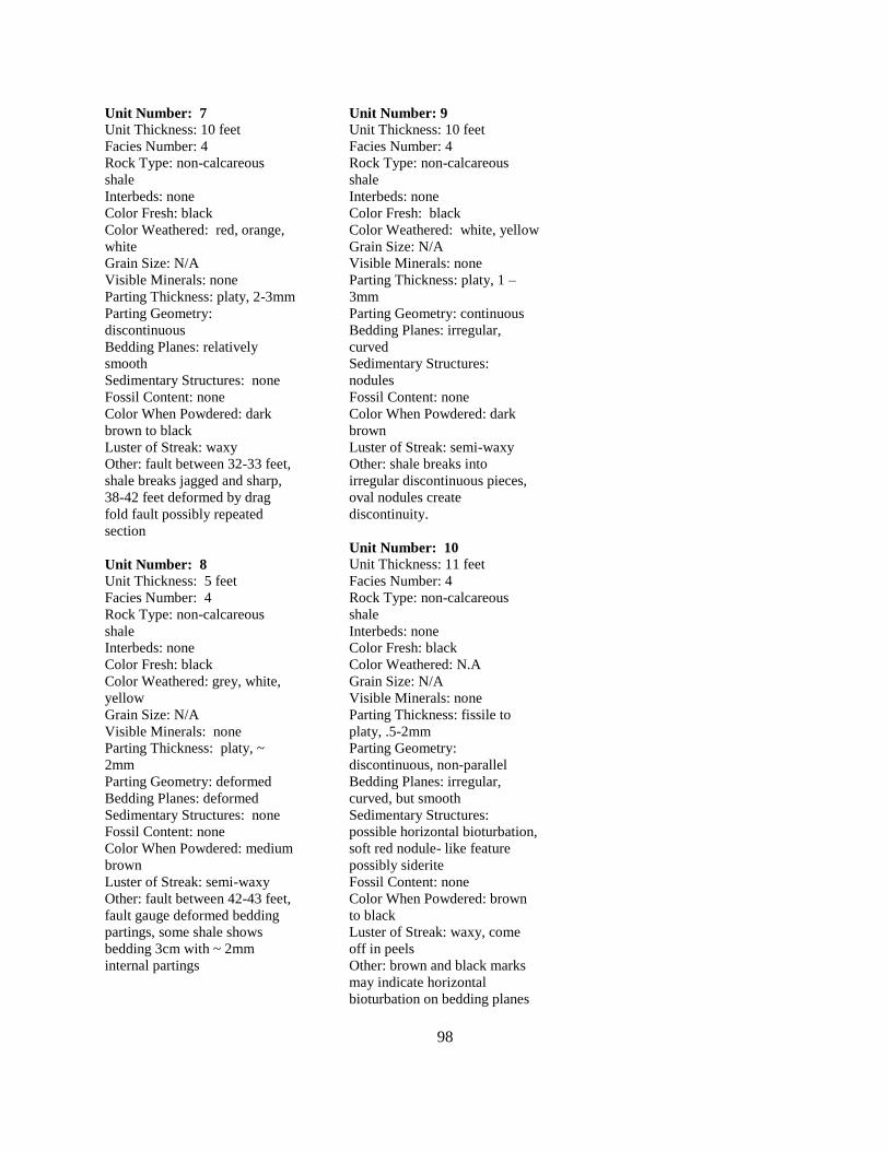
98
Unit Number: 7
Unit Thickness: 10 feet
Facies Number: 4
Rock Type: non-calcareous
shale
Interbeds: none
Color Fresh: black
Color Weathered: red, orange,
white
Grain Size: N/A
Visible Minerals: none
Parting Thickness: platy, 2-3mm
Parting Geometry:
discontinuous
Bedding Planes: relatively
smooth
Sedimentary Structures: none
Fossil Content: none
Color When Powdered: dark
brown to black
Luster of Streak: waxy
Other: fault between 32-33 feet,
shale breaks jagged and sharp,
38-42 feet deformed by drag
fold fault possibly repeated
section
Unit Number: 8
Unit Thickness: 5 feet
Facies Number: 4
Rock Type: non-calcareous
shale
Interbeds: none
Color Fresh: black
Color Weathered: grey, white,
yellow
Grain Size: N/A
Visible Minerals: none
Parting Thickness: platy, ~
2mm
Parting Geometry: deformed
Bedding Planes: deformed
Sedimentary Structures: none
Fossil Content: none
Color When Powdered: medium
brown
Luster of Streak: semi-waxy
Other: fault between 42-43 feet,
fault gauge deformed bedding
partings, some shale shows
bedding 3cm with ~ 2mm
internal partings
Unit Number: 9
Unit Thickness: 10 feet
Facies Number: 4
Rock Type: non-calcareous
shale
Interbeds: none
Color Fresh: black
Color Weathered: white, yellow
Grain Size: N/A
Visible Minerals: none
Parting Thickness: platy, 1 –
3mm
Parting Geometry: continuous
Bedding Planes: irregular,
curved
Sedimentary Structures:
nodules
Fossil Content: none
Color When Powdered: dark
brown
Luster of Streak: semi-waxy
Other: shale breaks into
irregular discontinuous pieces,
oval nodules create
discontinuity.
Unit Number: 10
Unit Thickness: 11 feet
Facies Number: 4
Rock Type: non-calcareous
shale
Interbeds: none
Color Fresh: black
Color Weathered: N.A
Grain Size: N/A
Visible Minerals: none
Parting Thickness: fissile to
platy, .5-2mm
Parting Geometry:
discontinuous, non-parallel
Bedding Planes: irregular,
curved, but smooth
Sedimentary Structures:
possible horizontal bioturbation,
soft red nodule- like feature
possibly siderite
Fossil Content: none
Color When Powdered: brown
to black
Luster of Streak: waxy, come
off in peels
Other: brown and black marks
may indicate horizontal
bioturbation on bedding planes
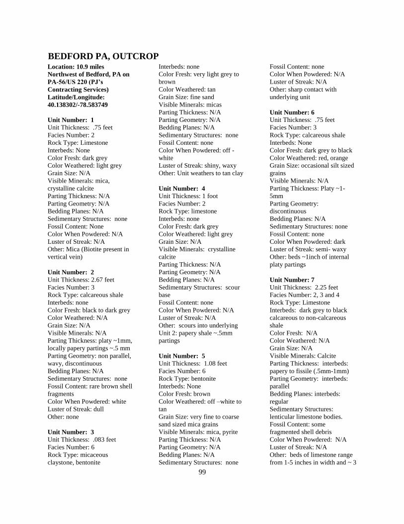
99
Location: 10.9 miles
Northwest of Bedford, PA on
PA-56/US 220 (PJ’s
Contracting Services)
Latitude/Longitude:
40.138302/-78.583749
Unit Number: 1
Unit Thickness: .75 feet
Facies Number: 2
Rock Type: Limestone
Interbeds: None
Color Fresh: dark grey
Color Weathered: light grey
Grain Size: N/A
Visible Minerals: mica,
crystalline calcite
Parting Thickness: N/A
Parting Geometry: N/A
Bedding Planes: N/A
Sedimentary Structures: none
Fossil Content: None
Color When Powdered: N/A
Luster of Streak: N/A
Other: Mica (Biotite present in
vertical vein)
Unit Number: 2
Unit Thickness: 2.67 feet
Facies Number: 3
Rock Type: calcareous shale
Interbeds: none
Color Fresh: black to dark grey
Color Weathered: N/A
Grain Size: N/A
Visible Minerals: N/A
Parting Thickness: platy ~1mm,
locally papery partings ~.5 mm
Parting Geometry: non parallel,
wavy, discontinuous
Bedding Planes: N/A
Sedimentary Structures: none
Fossil Content: rare brown shell
fragments
Color When Powdered: white
Luster of Streak: dull
Other: none
Unit Number: 3
Unit Thickness: .083 feet
Facies Number: 6
Rock Type: micaceous
claystone, bentonite
Interbeds: none
Color Fresh: very light grey to
brown
Color Weathered: tan
Grain Size: fine sand
Visible Minerals: micas
Parting Thickness: N/A
Parting Geometry: N/A
Bedding Planes: N/A
Sedimentary Structures: none
Fossil Content: none
Color When Powdered: off -
white
Luster of Streak: shiny, waxy
Other: Unit weathers to tan clay
Unit Number: 4
Unit Thickness: 1 foot
Facies Number: 2
Rock Type: limestone
Interbeds: none
Color Fresh: dark grey
Color Weathered: light grey
Grain Size: N/A
Visible Minerals: crystalline
calcite
Parting Thickness: N/A
Parting Geometry: N/A
Bedding Planes: N/A
Sedimentary Structures: scour
base
Fossil Content: none
Color When Powdered: N/A
Luster of Streak: N/A
Other: scours into underlying
Unit 2: papery shale ~.5mm
partings
Unit Number: 5
Unit Thickness: 1.08 feet
Facies Number: 6
Rock Type: bentonite
Interbeds: None
Color Fresh: brown
Color Weathered: off –white to
tan
Grain Size: very fine to coarse
sand sized mica grains
Visible Minerals: mica, pyrite
Parting Thickness: N/A
Parting Geometry: N/A
Bedding Planes: N/A
Sedimentary Structures: none
Fossil Content: none
Color When Powdered: N/A
Luster of Streak: N/A
Other: sharp contact with
underlying unit
Unit Number: 6
Unit Thickness: .75 feet
Facies Number: 3
Rock Type: calcareous shale
Interbeds: None
Color Fresh: dark grey to black
Color Weathered: red, orange
Grain Size: occasional silt sized
grains
Visible Minerals: N/A
Parting Thickness: Platy ~1-
5mm
Parting Geometry:
discontinuous
Bedding Planes: N/A
Sedimentary Structures: none
Fossil Content: none
Color When Powdered: dark
Luster of Streak: semi- waxy
Other: beds ~1inch of internal
platy partings
Unit Number: 7
Unit Thickness: 2.25 feet
Facies Number: 2, 3 and 4
Rock Type: Limestone
Interbeds: dark grey to black
calcareous to non-calcareous
shale
Color Fresh: N/A
Color Weathered: N/A
Grain Size: N/A
Visible Minerals: Calcite
Parting Thickness: interbeds:
papery to fissile (.5mm-1mm)
Parting Geometry: interbeds:
parallel
Bedding Planes: interbeds:
regular
Sedimentary Structures:
lenticular limestone bodies.
Fossil Content: some
fragmented shell debris
Color When Powdered: N/A
Luster of Streak: N/A
Other: beds of limestone range
from 1-5 inches in width and ~ 3
BEDFORD PA, OUTCROP
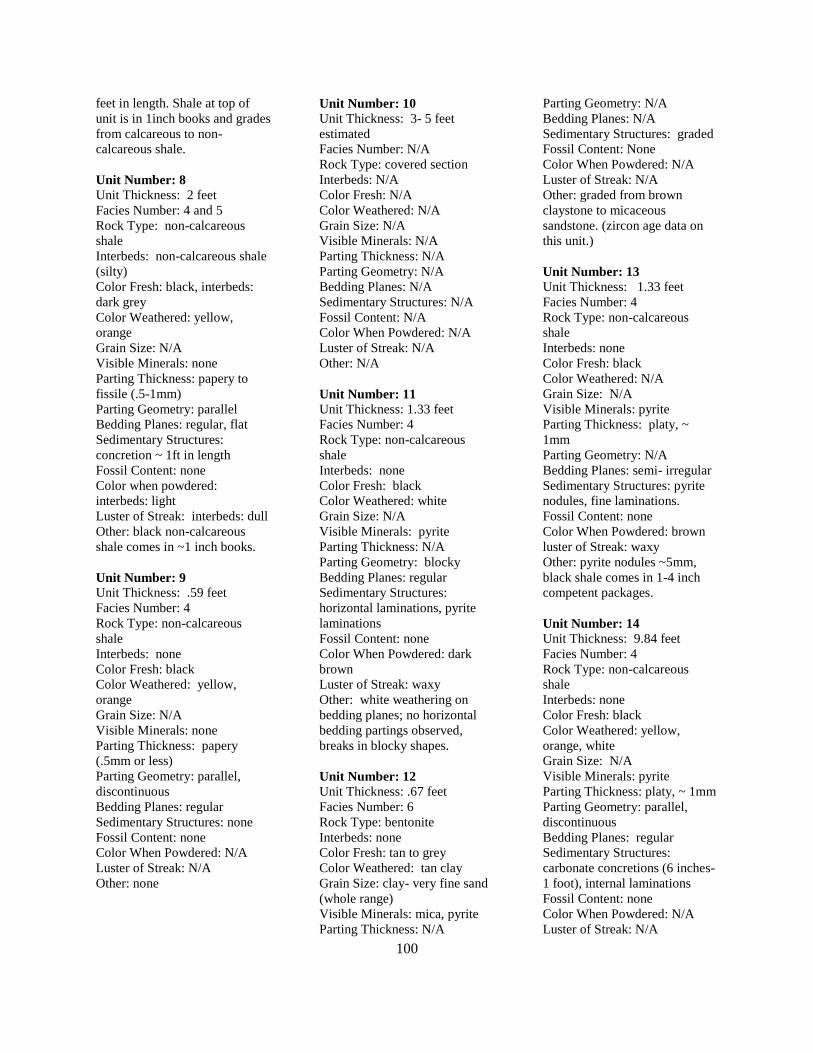
100
feet in length. Shale at top of
unit is in 1inch books and grades
from calcareous to non-
calcareous shale.
Unit Number: 8
Unit Thickness: 2 feet
Facies Number: 4 and 5
Rock Type: non-calcareous
shale
Interbeds: non-calcareous shale
(silty)
Color Fresh: black, interbeds:
dark grey
Color Weathered: yellow,
orange
Grain Size: N/A
Visible Minerals: none
Parting Thickness: papery to
fissile (.5-1mm)
Parting Geometry: parallel
Bedding Planes: regular, flat
Sedimentary Structures:
concretion ~ 1ft in length
Fossil Content: none
Color when powdered:
interbeds: light
Luster of Streak: interbeds: dull
Other: black non-calcareous
shale comes in ~1 inch books.
Unit Number: 9
Unit Thickness: .59 feet
Facies Number: 4
Rock Type: non-calcareous
shale
Interbeds: none
Color Fresh: black
Color Weathered: yellow,
orange
Grain Size: N/A
Visible Minerals: none
Parting Thickness: papery
(.5mm or less)
Parting Geometry: parallel,
discontinuous
Bedding Planes: regular
Sedimentary Structures: none
Fossil Content: none
Color When Powdered: N/A
Luster of Streak: N/A
Other: none
Unit Number: 10
Unit Thickness: 3- 5 feet
estimated
Facies Number: N/A
Rock Type: covered section
Interbeds: N/A
Color Fresh: N/A
Color Weathered: N/A
Grain Size: N/A
Visible Minerals: N/A
Parting Thickness: N/A
Parting Geometry: N/A
Bedding Planes: N/A
Sedimentary Structures: N/A
Fossil Content: N/A
Color When Powdered: N/A
Luster of Streak: N/A
Other: N/A
Unit Number: 11
Unit Thickness: 1.33 feet
Facies Number: 4
Rock Type: non-calcareous
shale
Interbeds: none
Color Fresh: black
Color Weathered: white
Grain Size: N/A
Visible Minerals: pyrite
Parting Thickness: N/A
Parting Geometry: blocky
Bedding Planes: regular
Sedimentary Structures:
horizontal laminations, pyrite
laminations
Fossil Content: none
Color When Powdered: dark
brown
Luster of Streak: waxy
Other: white weathering on
bedding planes; no horizontal
bedding partings observed,
breaks in blocky shapes.
Unit Number: 12
Unit Thickness: .67 feet
Facies Number: 6
Rock Type: bentonite
Interbeds: none
Color Fresh: tan to grey
Color Weathered: tan clay
Grain Size: clay- very fine sand
(whole range)
Visible Minerals: mica, pyrite
Parting Thickness: N/A
Parting Geometry: N/A
Bedding Planes: N/A
Sedimentary Structures: graded
Fossil Content: None
Color When Powdered: N/A
Luster of Streak: N/A
Other: graded from brown
claystone to micaceous
sandstone. (zircon age data on
this unit.)
Unit Number: 13
Unit Thickness: 1.33 feet
Facies Number: 4
Rock Type: non-calcareous
shale
Interbeds: none
Color Fresh: black
Color Weathered: N/A
Grain Size: N/A
Visible Minerals: pyrite
Parting Thickness: platy, ~
1mm
Parting Geometry: N/A
Bedding Planes: semi- irregular
Sedimentary Structures: pyrite
nodules, fine laminations.
Fossil Content: none
Color When Powdered: brown
luster of Streak: waxy
Other: pyrite nodules ~5mm,
black shale comes in 1-4 inch
competent packages.
Unit Number: 14
Unit Thickness: 9.84 feet
Facies Number: 4
Rock Type: non-calcareous
shale
Interbeds: none
Color Fresh: black
Color Weathered: yellow,
orange, white
Grain Size: N/A
Visible Minerals: pyrite
Parting Thickness: platy, ~ 1mm
Parting Geometry: parallel,
discontinuous
Bedding Planes: regular
Sedimentary Structures:
carbonate concretions (6 inches-
1 foot), internal laminations
Fossil Content: none
Color When Powdered: N/A
Luster of Streak: N/A
101
Other: 1 inch books with
internal laminations, breaks in
angular fragments.
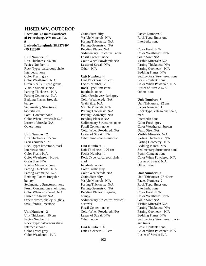
102
Location: 3.3 miles Southeast
of Petersburg, WV on Co. Rt.
9
Latitude/Longitude:38.957940/
-79.112806
Unit Number: 1
Unit Thickness: 66 cm
Facies Number: 1
Rock Type: calcareous shale
Interbeds: none
Color Fresh: grey
Color Weathered: N/A
Grain Size: silt sized grains
Visible Minerals: N/A
Parting Thickness: N/A
Parting Geometry: N/A
Bedding Planes: irregular,
bumpy
Sedimentary Structures:
bioturbated
Fossil Content: none
Color When Powdered: N/A
Luster of Streak: N/A
Other: none
Unit Number: 2
Unit Thickness: 15 cm
Facies Number: 2
Rock Type: limestone, marl
Interbeds: none
Color Fresh: N/A
Color Weathered: brown
Grain Size: N/A
Visible Minerals: none
Parting Thickness: N/A
Parting Geometry: N/A
Bedding Planes: irregular
bumpy
Sedimentary Structures: none
Fossil Content: one shell found
Color When Powdered: N/A
Luster of Streak: N/A
Other: brown, shaley, slightly
fossiliferous limestone
Unit Number: 3
Unit Thickness: 50 cm
Facies Number: 1
Rock Type: calcareous shale
Interbeds: none
Color Fresh: grey
Color Weathered: N/A
Grain Size: silty
Visible Minerals: N/A
Parting Thickness: N/A
Parting Geometry: N/A
Bedding Planes: N/A
Sedimentary Structures: none
Fossil Content: none
Color When Powdered: N/A
Luster of Streak: N/A
Other: N/A
Unit Number: 4
Unit Thickness: 26 cm
Facies Number: 2
Rock Type: limestone
Interbeds: none
Color Fresh: very dark grey
Color Weathered: N/A
Grain Size: N/A
Visible Minerals: N/A
Parting Thickness: N/A
Parting Geometry: N/A
Bedding Planes: N/A
Sedimentary Structures: none
Fossil Content: none
Color When Powdered: N/A
Luster of Streak: N/A
Other: limestone is micritic
Unit Number: 5
Unit Thickness: 126 cm
Facies Number: 1
Rock Type: calcareous shale,
marl
Interbeds: none
Color Fresh: grey
Color Weathered: N/A
Grain Size: silty
Visible Minerals: N/A
Parting Thickness: N/A
Parting Geometry: N/A
Bedding Planes: irregular,
bumpy
Sedimentary Structures: vertical
burrows
Fossil Content: none
Color When Powdered: N/A
Luster of Streak: N/A
Other: none
Unit Number: 6
Unit Thickness: 12 cm
Facies Number: 2
Rock Type: limestone
Interbeds: none
Color Fresh: N/A
Color Weathered: N/A
Grain Size: N/A
Visible Minerals: N/A
Parting Thickness: N/A
Parting Geometry: N/A
Bedding Planes: N/A
Sedimentary Structures: none
Fossil Content: none
Color When Powdered: N/A
Luster of Streak: N/A
Other: none
Unit Number: 7
Unit Thickness: 22 cm
Facies Number: 1
Rock Type: calcareous shale,
marl
Interbeds: none
Color Fresh: grey
Color Weathered: brown
Grain Size: N/A
Visible Minerals: N/A
Parting Thickness: N/A
Parting Geometry: N/A
Bedding Planes: N/A
Sedimentary Structures: none
Fossil Content: none
Color When Powdered: N/A
Luster of Streak: N/A
Other: none
Unit Number: 8
Unit Thickness: 27-40 cm
Facies Number: 2
Rock Type: limestone
Interbeds: none
Color Fresh: N/A
Color Weathered: N/A
Grain Size: N/A
Visible Minerals: N/A
Parting Thickness: N/A
Parting Geometry: N/A
Bedding Planes: N/A
Sedimentary Structures: tracks
and trails
Fossil Content: none
Color When Powdered: N/A
Luster of Streak: N/A
HISER WV, OUTCROP
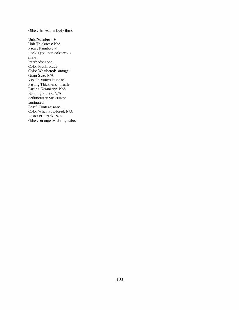
103
Other: limestone body thins
Unit Number: 9
Unit Thickness: N/A
Facies Number: 4
Rock Type: non-calcareous
shale
Interbeds: none
Color Fresh: black
Color Weathered: orange
Grain Size: N/A
Visible Minerals: none
Parting Thickness: fissile
Parting Geometry: N/A
Bedding Planes: N/A
Sedimentary Structures:
laminated
Fossil Content: none
Color When Powdered: N/A
Luster of Streak: N/A
Other: orange oxidizing halos
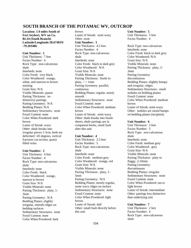
104
Location: 1.9 miles South of
Fort Seybert, WV on Co.
Rt.34 (South Branch)
Latitude/Longitude:38.674019/
-79.203486
Unit Number: 1
Unit Thickness: 7 feet
Facies Number: 4
Rock Type: non-calcareous
shale
Interbeds: none
Color Fresh: very black
Color Weathered: orange,
white, and maroon to brown
staining
Grain Size: N/A
Visible Minerals: quartz
Parting Thickness: no
distinctive partings
Parting Geometry: N/A
Bedding Planes: N/A
Sedimentary Structures: none
Fossil Content: none
Color When Powdered: dark
brown
Luster of Streak: waxy
Other: shale breaks into
irregular pieces 1-3cm, beds are
deformed ~45 degrees, vertical
fractures cut section, quartz
filled veins
Unit Number: 2
Unit Thickness: 4 feet
Facies Number: 4
Rock Type: non-calcareous
shale
Interbeds: none
Color Fresh: black
Color Weathered: orange,
maroon to brown
Grain Size: N/A
Visible Minerals: none
Parting Thickness: platy, 1-
3mm
Parting Geometry: N/A
Bedding Planes: slightly
irregular, smooth ridges on
bedding surfaces
Sedimentary Structures: none
Fossil Content: none
Color When Powdered: dark
brown
Luster of Streak: semi waxy
Other: none
Unit Number: 3
Unit Thickness: 4.5 feet
Facies Number: 4
Rock Type: non-calcareous
shale
Interbeds: none
Color Fresh: black to dark grey
Color Weathered: N/A
Grain Size: N/A
Visible Minerals: none
Parting Thickness: fissile to
platy, ~ < 1mm
Parting Geometry: parallel,
continuous
Bedding Planes: regular, nearly
smooth
Sedimentary Structures: none
Fossil Content: none
Color When Powdered: medium
brown
Luster of Streak: semi-waxy
Other: shale breaks into fissile
sheets, shale partings are in
competent books, small fault
after this unit
Unit Number: 4
Unit Thickness: 2.5 feet
Facies Number: 5
Rock Type: non-calcareous
shale
Interbeds: none
Color Fresh: medium grey
Color Weathered: orange, red
Grain Size: N/A
Visible Minerals: none
Parting Thickness: platy, 1-
5mm
Parting Geometry: N/A
Bedding Planes: mostly regular,
some wavy ridges on surface
Sedimentary Structures: none
Fossil Content: none
Color When Powdered: light
brown
Luster of Streak: dull
Other: small fault directly before
this unit
Unit Number: 5
Unit Thickness: 5 feet
Facies Number: 4
Rock Type: non-calcareous
Interbeds: none
Color Fresh: black to dark grey
Color Weathered: N/A
Grain Size: N/A
Visible Minerals: none
Parting Thickness: platy, 2-
3mm
Parting Geometry:
discontinuous
Bedding Planes: slightly bumpy
and irregular, ridges
Sedimentary Structures: small
nodules on bedding planes
Fossil Content: none
Color When Powdered: medium
brown
Luster of Streak: semi-waxy
Other: nodules are raised bumps
on bedding planes (incipient)
Unit Number: 6
Unit Thickness: 3 feet
Facies Number: 5
Rock Type: non-calcareous
shale
Interbeds: none
Color Fresh: medium grey
Color Weathered: grey
Grain Size: N/A
Visible Minerals: none
Parting Thickness: platy to
flaggy, 2-10mm
Parting Geometry:
discontinuous
Bedding Planes: irregular
Sedimentary Structures: none
Fossil Content: none
Color When Powdered: tan to
light brown
Luster of Streak: intermediate
Other: partings less distinctive
than underlying unit
Unit Number: 7
Unit Thickness: 2 feet
Facies Number: 4
Rock Type: non-calcareous
shale
SOUTH BRANCH OF THE POTAMAC WV, OUTCROP
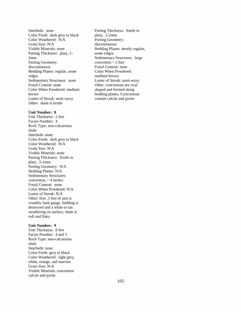
105
Interbeds: none
Color Fresh: dark grey to black
Color Weathered: N/A
Grain Size: N/A
Visible Minerals: none
Parting Thickness: platy, 1-
2mm
Parting Geometry:
discontinuous
Bedding Planes: regular, some
ridges
Sedimentary Structures: none
Fossil Content: none
Color When Powdered: medium
brown
Luster of Streak: semi-waxy
Other: shale is brittle
Unit Number: 8
Unit Thickness: 2 feet
Facies Number: 4
Rock Type: non-calcareous
shale
Interbeds: none
Color Fresh: dark grey to black
Color Weathered: N/A
Grain Size: N/A
Visible Minerals: none
Parting Thickness: fissile to
platy, .5-1mm
Parting Geometry: N/A
Bedding Planes: N/A
Sedimentary Structures:
concretion, ~ 4 inches
Fossil Content: none
Color When Powdered: N/A
Luster of Streak: N/A
Other: first .3 feet of unit is
crumbly fault gauge, bedding is
destroyed and a white to tan
weathering on surface, shale is
soft and flaky
Unit Number: 9
Unit Thickness: 8 feet
Facies Number: 4 and 5
Rock Type: non-calcareous
shale
Interbeds: none
Color Fresh: grey to black
Color Weathered: light grey,
white, orange, and maroon
Grain Size: N/A
Visible Minerals: concretion:
calcite and pyrite
Parting Thickness: fissile to
platy, .5-2mm
Parting Geometry:
discontinuous
Bedding Planes: mostly regular,
some ridges
Sedimentary Structures: large
concretion ~ 2 feet
Fossil Content: none
Color When Powdered:
medium brown
Luster of Streak: semi-waxy
Other: concretions are oval
shaped and formed along
bedding planes, Concretions
contain calcite and pyrite
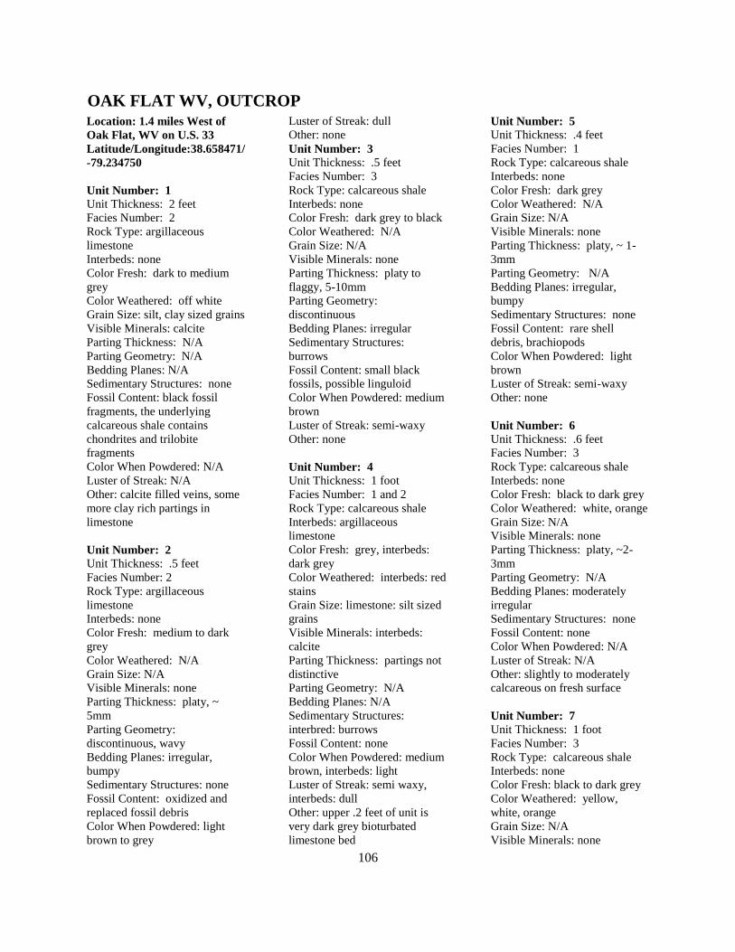
106
Location: 1.4 miles West of
Oak Flat, WV on U.S. 33
Latitude/Longitude:38.658471/
-79.234750
Unit Number: 1
Unit Thickness: 2 feet
Facies Number: 2
Rock Type: argillaceous
limestone
Interbeds: none
Color Fresh: dark to medium
grey
Color Weathered: off white
Grain Size: silt, clay sized grains
Visible Minerals: calcite
Parting Thickness: N/A
Parting Geometry: N/A
Bedding Planes: N/A
Sedimentary Structures: none
Fossil Content: black fossil
fragments, the underlying
calcareous shale contains
chondrites and trilobite
fragments
Color When Powdered: N/A
Luster of Streak: N/A
Other: calcite filled veins, some
more clay rich partings in
limestone
Unit Number: 2
Unit Thickness: .5 feet
Facies Number: 2
Rock Type: argillaceous
limestone
Interbeds: none
Color Fresh: medium to dark
grey
Color Weathered: N/A
Grain Size: N/A
Visible Minerals: none
Parting Thickness: platy, ~
5mm
Parting Geometry:
discontinuous, wavy
Bedding Planes: irregular,
bumpy
Sedimentary Structures: none
Fossil Content: oxidized and
replaced fossil debris
Color When Powdered: light
brown to grey
Luster of Streak: dull
Other: none
Unit Number: 3
Unit Thickness: .5 feet
Facies Number: 3
Rock Type: calcareous shale
Interbeds: none
Color Fresh: dark grey to black
Color Weathered: N/A
Grain Size: N/A
Visible Minerals: none
Parting Thickness: platy to
flaggy, 5-10mm
Parting Geometry:
discontinuous
Bedding Planes: irregular
Sedimentary Structures:
burrows
Fossil Content: small black
fossils, possible linguloid
Color When Powdered: medium
brown
Luster of Streak: semi-waxy
Other: none
Unit Number: 4
Unit Thickness: 1 foot
Facies Number: 1 and 2
Rock Type: calcareous shale
Interbeds: argillaceous
limestone
Color Fresh: grey, interbeds:
dark grey
Color Weathered: interbeds: red
stains
Grain Size: limestone: silt sized
grains
Visible Minerals: interbeds:
calcite
Parting Thickness: partings not
distinctive
Parting Geometry: N/A
Bedding Planes: N/A
Sedimentary Structures:
interbred: burrows
Fossil Content: none
Color When Powdered: medium
brown, interbeds: light
Luster of Streak: semi waxy,
interbeds: dull
Other: upper .2 feet of unit is
very dark grey bioturbated
limestone bed
Unit Number: 5
Unit Thickness: .4 feet
Facies Number: 1
Rock Type: calcareous shale
Interbeds: none
Color Fresh: dark grey
Color Weathered: N/A
Grain Size: N/A
Visible Minerals: none
Parting Thickness: platy, ~ 1-
3mm
Parting Geometry: N/A
Bedding Planes: irregular,
bumpy
Sedimentary Structures: none
Fossil Content: rare shell
debris, brachiopods
Color When Powdered: light
brown
Luster of Streak: semi-waxy
Other: none
Unit Number: 6
Unit Thickness: .6 feet
Facies Number: 3
Rock Type: calcareous shale
Interbeds: none
Color Fresh: black to dark grey
Color Weathered: white, orange
Grain Size: N/A
Visible Minerals: none
Parting Thickness: platy, ~2-
3mm
Parting Geometry: N/A
Bedding Planes: moderately
irregular
Sedimentary Structures: none
Fossil Content: none
Color When Powdered: N/A
Luster of Streak: N/A
Other: slightly to moderately
calcareous on fresh surface
Unit Number: 7
Unit Thickness: 1 foot
Facies Number: 3
Rock Type: calcareous shale
Interbeds: none
Color Fresh: black to dark grey
Color Weathered: yellow,
white, orange
Grain Size: N/A
Visible Minerals: none
OAK FLAT WV, OUTCROP
107
Parting Thickness: papery to
fissile, ~ .1mm or less
Parting Geometry: parallel
Bedding Planes: regular, flat
Sedimentary Structures: none
Fossil Content: none
Color When Powdered: N/A
Luster of Streak: N/A
Other: fresh surface is very
calcareous, shale in books ~1 –
6 inches, some grey shale with
platy parting ~ 3-5mm.
Unit Number: 8
Unit Thickness: 2 feet
Facies Number: 3
Rock Type: calcareous shale
Interbeds: none
Color Fresh: dark grey
Color Weathered: grey to blue,
white
Grain Size: none
Visible Minerals: none
Parting Thickness: platy to
flaggy, ~2-10mm
Parting Geometry: wavy,
discontinuous
Bedding Planes: irregular,
bumpy
Sedimentary Structures:
oxidized burrows, nodules
Fossil Content: none
Color When Powdered: brown,
peels
Luster of Streak: semi-waxy
Other: burrows have red orange
weathering, nodules are flat,
oval shaped and have high
specific gravity, last foot of unit
has no distinctive parting
thickness and may be
bioturbated: has a dull streak
and white powder.
Unit Number: 9
Unit Thickness: 2 feet
Facies Number: 3
Rock Type: calcareous shale
Interbeds: none
Color Fresh: dark grey
Color Weathered: N/A
Grain Size: sand sized
Visible Minerals: calcite
Parting Thickness: flaggy, ~
10mm, or no distinctive partings
Parting Geometry: N/A
Bedding Planes: irregular
Sedimentary Structures:
oxidized horizontal and vertical
burrows, nodules
Fossil Content: some black
shell debris
Color When Powdered: light
Luster of Streak: dull
Other: nodules are flat, oval
shaped and have high specific
gravity, upper foot of unit is
very weathered and crumbly,
breaks into nodule like pieces
Unit Number: 10
Unit Thickness: 1.5 feet
Facies Number: 3
Rock Type: calcareous shale
Interbeds: N/A
Color Fresh: black
Color Weathered: white and
orange crust on surface
Grain Size: N/A
Visible Minerals: none
Parting Thickness: platy, 1-
2mm
Parting Geometry: deformed
Bedding Planes: deformed
Sedimentary Structures: small
siderite concretions
Fossil Content: none
Color When Powdered: N/A
Luster of Streak: N/A
Other: beds deformed, very
black and coaly
Unit Number: 11
Unit Thickness: 1.1 feet
Facies Number: 1
Rock Type: calcareous shale
Interbeds: none
Color Fresh: medium to dark
grey
Color Weathered: light grey
Grain Size: N/A
Visible Minerals: none
Parting Thickness: platy, 2-
5mm
Parting Geometry: non-parallel
Bedding Planes: irregular,
bumpy
Sedimentary Structures:
oxidized burrows
Fossil Content: none
Color When Powdered: medium
blue to grey
Luster of Streak: semi-waxy
Other: partings become thinner
towards top of unit ~ 2mm
Unit Number: 12
Unit Thickness: .4 feet
Facies Number: 2
Rock Type: limestone
Interbeds: none
Color Fresh: dark grey
Color Weathered: N/A
Grain Size: sand sized
Visible Minerals: calcite
Parting Thickness: N/A
Parting Geometry: N/A
Bedding Planes: N/A
Sedimentary Structures: N/A
Fossil Content: fossil debris
Color When Powdered: N/A
Luster of Streak: N/A
Other: limestone bed pinches
out
Unit Number: 13
Unit Thickness: .5 feet
Facies Number: 3
Rock Type: calcareous shale
Interbeds: none
Color Fresh: black to dark grey
Color Weathered: N/A
Grain Size: N/A
Visible Minerals: none
Parting Thickness: platy to
flaggy, 3-10mm
Parting Geometry:
discontinuous
Bedding Planes: irregular
Sedimentary Structures: N/A
Fossil Content: possible fossil
debris
Color When Powdered: N/A
Luster of Streak: N/A
Other: N/A
Unit Number: 14
Unit Thickness: 2.5 feet
Facies Number: 3
Rock Type: calcareous shale
Interbeds: none
Color Fresh: dark grey
Color Weathered: N/A
Grain Size: N/A
Visible Minerals: none
108
Parting Thickness: platy, 1-
5mm
Parting Geometry: not parallel
Bedding Planes: irregular,
bumpy
Sedimentary Structures: none
Fossil Content: possible fossil
debris
Color When Powdered: N/A
Luster of Streak: N/A
Other: some more competent,
very thin, micritic limestone
beds in this section
Unit Number: 15
Unit Thickness: 4 feet
Facies Number: N/A
Rock Type: Covered section
Interbeds: N/A
Color Fresh: N/A
Color Weathered: N/A
Grain Size: N/A
Visible Minerals: N/A
Parting Thickness: N/A
Parting Geometry: N/A
Bedding Planes: N/A
Sedimentary Structures: N/A
Fossil Content: N/A
Color When Powdered: N/A
Luster of Streak: N/A
Other: estimated 4 feet, lies
between previous unit and
deformed black shale
Unit Number: 16
Unit Thickness: estimated ~18
feet of shale
Facies Number: 4
Rock Type: non-calcareous
shale
Interbeds: none
Color Fresh: black
Color Weathered: yellow,
white, orange
Grain Size: N/A
Visible Minerals: none
Parting Thickness: platy, 2-3m
Parting Geometry: continuous
Bedding Planes: flat, regular
Sedimentary Structures:
Fossil Content: none
Color When Powdered: dark
Luster of Streak: semi-waxy
Other: repeated section, shale is
highly deformed and kink
folded, parting and bedding
characteristics have been mostly
destroyed, stratigraphic order
and thickness is unknown due to
high degree of deformation
109
Location: U.S. Silica Quarry
3.3 miles North of Berkeley
Springs, WV on U.S. Rt. 522
Latitude/Longitude:39.669142/
-78.200169
Notes: Both Oriskany/Needmore
and Needmore/ Marcellus
contacts are exposed. Beds of
the Marcellus change dig rapidly
throughout section ~ 45- 90
degrees. Very hot (high
uranium) black shale from base
of Marcellus seem to be
missing. Large fault is found at
base of section near the
Needmore/Marcellus contact.
Upper section of Marcellus/
Mahantango is extremely folded
and faulted. Large recumbent
fold and high displacement
thrust faults have made it
difficult to determine true
stratigraphic order of beds
measured. Lower portion of
sections seems to be in correct
stratigraphic order.
Unit Number: 1
Unit Thickness: ~ 40 feet
Facies Number: N/A
Rock Type: Needmore shale,
non-calcareous
Interbeds: calcareous shale,
argillaceous limestone
Color Fresh: medium grey to
blue
Color Weathered: light grey,
buff, tan, white
Grain Size: N/A
Visible Minerals: calcite
Parting Thickness: not
distinctive
Parting Geometry:
discontinuous
Bedding Planes: irregular, wavy
Sedimentary Structures: burrows
Fossil Content: brachiopods,
trilobites, cephalopods
Color When Powdered: light tan
to white
Luster of Streak: dull
Other: burrows filled with
darker mud from below, fault
plane observed between
Needmore shale and Marcellus
shale, contact looks abrupt
Unit Number: 2
Unit Thickness: 1 foot
Facies Number: 4
Rock Type: non-calcareous
Interbeds: none
Color Fresh: dark grey to black
Color Weathered: grey, orange,
and red
Grain Size: N/A
Visible Minerals: none
Parting Thickness: papery, ~ .5
mm
Parting Geometry:
discontinuous, soft and flaky
Bedding Planes: mostly flat and
regular
Sedimentary Structures: none
Fossil Content: none
Color When Powdered: light to
medium grey
Luster of Streak: semi -waxy
Other: this unit is the along the
Needmore/Marcellus contact,
movement along contact, shale
is flaky and soft
Unit Number: 3
Unit Thickness: 9 feet
Facies Number: 5
Rock Type: non-calcareous
shale
Interbeds: none
Color Fresh: medium to dark
grey
Color Weathered: tan, orange
Grain Size: N/A
Visible Minerals: calcite in fault
gauge, small unknown crystals
on bedding planes
Parting Thickness: papery to
fissile, .5-1mm
Parting Geometry: N/A
Bedding Planes: regular to
slightly irregular
Sedimentary Structures: nodule
Fossil Content: none
Color When Powdered: N/A
Luster of Streak: N/A
Other: 4- 5 feet of fault gauge,
fault gauge has calcite filled
veins, beds deformed and locally
change dip
Unit Number: 4
Unit Thickness: 6 feet
Facies Number: 5
Rock Type: non-calcareous
shale
Interbeds: none
Color Fresh: dark grey
Color Weathered: grey, nodules
weather tan
Grain Size: N/A
Visible Minerals: nodule: calcite
and pyrite
Parting Thickness: papery to
fissile, ~ .5-1mm
Parting Geometry:
discontinuous
Bedding Planes: irregular
Sedimentary Structures:
concretions and nodules
Fossil Content: small shell
fragments in concretions
Color When Powdered: N/A
Luster of Streak: N/A
Other: small calcareous nodule
is very black and contains
euhedral pyrite cubes, large dark
grey concretions are very
calcareous, oval shaped, contain
small white shell fragments and
are ~ 1-2 feet in length, flaky
grey shale directly above large
concretions.
Unit Number: 5
Unit Thickness: 10 feet
Facies Number: 4
Rock Type: non-calcareous
shale
Interbeds: none
Color Fresh: dark grey to black
Color Weathered: orange, red,
white, yellow
Grain Size: N/A
Visible Minerals: unknown
mineral on parting surfaces
Parting Thickness: platy, 1-
2mm
BERKELEY SPRINGS WV, OUTCROP
110
Parting Geometry: N/A
Bedding Planes: regular, flat
Sedimentary Structures: none
Fossil Content: none
Color When Powdered: light to
medium brown
Luster of Streak: dull
Other: precipitate crystals on
bedding planes, crystals have
pearly luster and basal cleavage,
thin veins of white and yellow
weathering on partings surfaces
Unit Number: 6
Unit Thickness: 15 feet
Facies Number: 3 and 4
Rock Type: non-calcareous to
slightly calcareous
Interbeds: none
Color Fresh: dark grey to black
Color Weathered: grey
Grain Size: N/A
Visible Minerals: calcite
Parting Thickness: papery to
fissile, ~ .5mm
Parting Geometry:
discontinuous
Bedding Planes: relatively
regular
Sedimentary Structures: large
calcareous concretions
Fossil Content: none
Color When Powdered: light to
medium brown
Luster of Streak: dull
Other: Two distinctive beds of
large oval shaped nodules ~ 1-5
feet in length, shale is more
calcareous near concretions, and
concretions contain numerous
large and small calcite filled
veins
Unit Number: 7
Unit Thickness: 21 feet
Facies Number: 4
Rock Type: non-calcareous
Interbeds: none
Color Fresh: dark grey to black
Color Weathered: orange,
maroon, tan
Grain Size: N/A
Visible Minerals: quartz in
healed fractures and veins
Parting Thickness: 1) platy, ~
2mm or 2) papery to fissile, .5-
1mm
Parting Geometry: 1)
continuous or 2) discontinuous
Bedding Planes: 1) regular or 2)
irregular
Sedimentary Structures: dark
grey, round, calcareous
concretions
Fossil Content: none
Color When Powdered: light to
medium brown
Luster of Streak: dull
Other: the shale throughout this
unit alternates between two
parting styles ( 1and 2), unit
contains faults and folds and
large cross cutting quartz veins,
concretions found in lower 2
feet of unit
Unit Number: 8
Unit Thickness: 14 feet
Facies Number: 5
Rock Type: non-calcareous
shale
Interbeds: none
Color Fresh: dark grey
Color Weathered: N/A
Grain Size: silt sized grains
Visible Minerals: quartz in
healed veins
Parting Thickness: platy, 2-
5mm
Parting Geometry:
discontinuous
Bedding Planes: N/A
Sedimentary Structures: bedded
nodules (siderite?)
Fossil Content: none
Color When Powdered: light
Luster of Streak: dull
Other: nodules are non-
calcareous to slightly calcareous
on fresh surface, dark grey and
flattened, some layers of
concretions form thin beds, unit
contains fault gauge and quartz
filled veins
Unit Number: 9
Unit Thickness: 27 feet
Facies Number: 5
Rock Type: non-calcareous
shale (silty)
Interbeds: none
Color Fresh: dark grey
Color Weathered: N/A
Grain Size: N/A
Visible Minerals: quartz in
healed fractures
Parting Thickness: platy, 1-
2mm
Parting Geometry: N/A
Bedding Planes: regular to
slightly irregular
Sedimentary Structures: bedded
calcareous nodules (siderite?)
Fossil Content: none
Color When Powdered: light,
tan
Luster of Streak: dull
Other: first two feet of unit are
fault gauge, fault gauge has
quartz filled veins and orange
weathering, nodules form beds
that can be traced through the
outcrop, grey non-calcareous
shale is interbedded with
calcareous nodule beds ~ 5mm
to 2 inch thick
Unit Number: 10
Unit Thickness: 4 feet
Facies Number: 5 and 1
Rock Type: non-calcareous
shale (silty)
Interbeds: calcareous mudstone
or bedded calcareous nodules
Color Fresh: medium to dark
grey, interbeds: light grey
Color Weathered: interbeds: tan
Grain Size: silty sized grains
Visible Minerals: N/A
Parting Thickness: platy to
flaggy, ~ 1-10mm or no
distinctive partings
Parting Geometry:
discontinuous
Bedding Planes: slightly
irregular
Sedimentary Structures: none
Fossil Content: none
Color When Powdered: light
brown
Luster of Streak: dull
Other: interbeds only fizz when
fresh surface is tested could be
bedded nodules
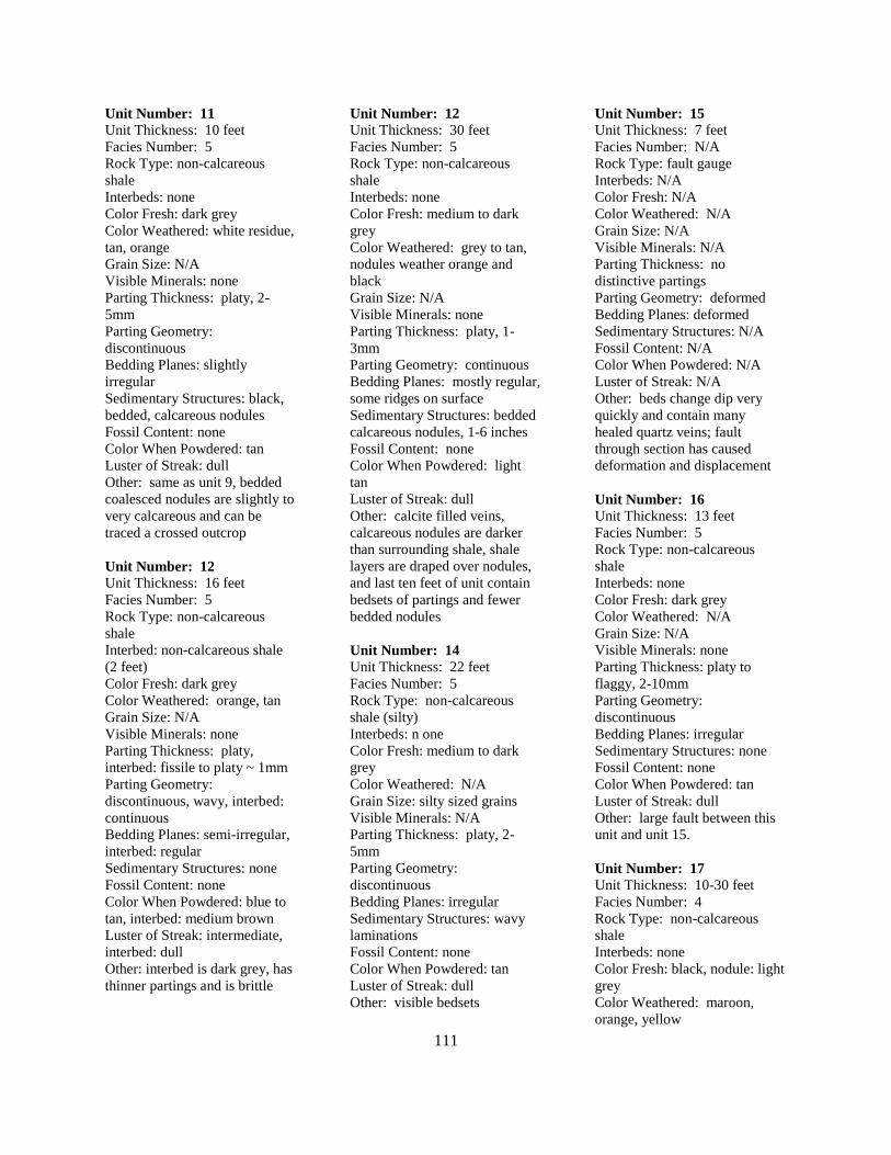
111
Unit Number: 11
Unit Thickness: 10 feet
Facies Number: 5
Rock Type: non-calcareous
shale
Interbeds: none
Color Fresh: dark grey
Color Weathered: white residue,
tan, orange
Grain Size: N/A
Visible Minerals: none
Parting Thickness: platy, 2-
5mm
Parting Geometry:
discontinuous
Bedding Planes: slightly
irregular
Sedimentary Structures: black,
bedded, calcareous nodules
Fossil Content: none
Color When Powdered: tan
Luster of Streak: dull
Other: same as unit 9, bedded
coalesced nodules are slightly to
very calcareous and can be
traced a crossed outcrop
Unit Number: 12
Unit Thickness: 16 feet
Facies Number: 5
Rock Type: non-calcareous
shale
Interbed: non-calcareous shale
(2 feet)
Color Fresh: dark grey
Color Weathered: orange, tan
Grain Size: N/A
Visible Minerals: none
Parting Thickness: platy,
interbed: fissile to platy ~ 1mm
Parting Geometry:
discontinuous, wavy, interbed:
continuous
Bedding Planes: semi-irregular,
interbed: regular
Sedimentary Structures: none
Fossil Content: none
Color When Powdered: blue to
tan, interbed: medium brown
Luster of Streak: intermediate,
interbed: dull
Other: interbed is dark grey, has
thinner partings and is brittle
Unit Number: 12
Unit Thickness: 30 feet
Facies Number: 5
Rock Type: non-calcareous
shale
Interbeds: none
Color Fresh: medium to dark
grey
Color Weathered: grey to tan,
nodules weather orange and
black
Grain Size: N/A
Visible Minerals: none
Parting Thickness: platy, 1-
3mm
Parting Geometry: continuous
Bedding Planes: mostly regular,
some ridges on surface
Sedimentary Structures: bedded
calcareous nodules, 1-6 inches
Fossil Content: none
Color When Powdered: light
tan
Luster of Streak: dull
Other: calcite filled veins,
calcareous nodules are darker
than surrounding shale, shale
layers are draped over nodules,
and last ten feet of unit contain
bedsets of partings and fewer
bedded nodules
Unit Number: 14
Unit Thickness: 22 feet
Facies Number: 5
Rock Type: non-calcareous
shale (silty)
Interbeds: n one
Color Fresh: medium to dark
grey
Color Weathered: N/A
Grain Size: silty sized grains
Visible Minerals: N/A
Parting Thickness: platy, 2-
5mm
Parting Geometry:
discontinuous
Bedding Planes: irregular
Sedimentary Structures: wavy
laminations
Fossil Content: none
Color When Powdered: tan
Luster of Streak: dull
Other: visible bedsets
Unit Number: 15
Unit Thickness: 7 feet
Facies Number: N/A
Rock Type: fault gauge
Interbeds: N/A
Color Fresh: N/A
Color Weathered: N/A
Grain Size: N/A
Visible Minerals: N/A
Parting Thickness: no
distinctive partings
Parting Geometry: deformed
Bedding Planes: deformed
Sedimentary Structures: N/A
Fossil Content: N/A
Color When Powdered: N/A
Luster of Streak: N/A
Other: beds change dip very
quickly and contain many
healed quartz veins; fault
through section has caused
deformation and displacement
Unit Number: 16
Unit Thickness: 13 feet
Facies Number: 5
Rock Type: non-calcareous
shale
Interbeds: none
Color Fresh: dark grey
Color Weathered: N/A
Grain Size: N/A
Visible Minerals: none
Parting Thickness: platy to
flaggy, 2-10mm
Parting Geometry:
discontinuous
Bedding Planes: irregular
Sedimentary Structures: none
Fossil Content: none
Color When Powdered: tan
Luster of Streak: dull
Other: large fault between this
unit and unit 15.
Unit Number: 17
Unit Thickness: 10-30 feet
Facies Number: 4
Rock Type: non-calcareous
shale
Interbeds: none
Color Fresh: black, nodule: light
grey
Color Weathered: maroon,
orange, yellow
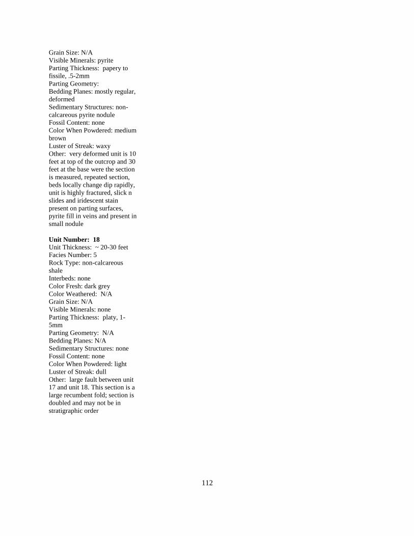
112
Grain Size: N/A
Visible Minerals: pyrite
Parting Thickness: papery to
fissile, .5-2mm
Parting Geometry:
Bedding Planes: mostly regular,
deformed
Sedimentary Structures: non-
calcareous pyrite nodule
Fossil Content: none
Color When Powdered: medium
brown
Luster of Streak: waxy
Other: very deformed unit is 10
feet at top of the outcrop and 30
feet at the base were the section
is measured, repeated section,
beds locally change dip rapidly,
unit is highly fractured, slick n
slides and iridescent stain
present on parting surfaces,
pyrite fill in veins and present in
small nodule
Unit Number: 18
Unit Thickness: ~ 20-30 feet
Facies Number: 5
Rock Type: non-calcareous
shale
Interbeds: none
Color Fresh: dark grey
Color Weathered: N/A
Grain Size: N/A
Visible Minerals: none
Parting Thickness: platy, 1-
5mm
Parting Geometry: N/A
Bedding Planes: N/A
Sedimentary Structures: none
Fossil Content: none
Color When Powdered: light
Luster of Streak: dull
Other: large fault between unit
17 and unit 18. This section is a
large recumbent fold; section is
doubled and may not be in
stratigraphic order
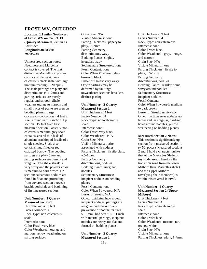
113
Location: 1.1 miles Northwest
of Frost, WV on Co. Rt. 13
(Quarry Measured Section 1)
Latitude/
Longitude:38.28330/-
79.885224
Unmeasured section notes:
Needmore and Marcellus
contact is covered. The first
distinctive Marcellus exposure
consists of Facies 4, non-
calcareous black shale with high
uranium reading (~ 20 ppm).
The shale partings are platy and
discontinuous (~ 1-2mm) and
parting surfaces are mostly
regular and smooth. Shale
weathers orange to maroon and
small traces of pyrite are seen on
bedding planes. Large
calcareous concretion ~ 4 feet in
size is found in this section. Up
section ~15 feet from first
measured section, Facies 5, non-
calcareous medium grey shale
contains several thin beds of
abundant brachiopod fossils of a
single species. Shale also
contains mud filled or red
oxidized burrow. The bedding
partings are platy 5mm and
parting surfaces are bumpy and
irregular. The shale streak is
very waxy and the powder color
is medium to dark brown. Up
section: calcareous nodules are
found in float and protruding
from covered section between
brachiopod shale and beginning
of first measured section.
Unit Number: 1 Quarry
Measured Section1
Unit Thickness: 9 feet
Facies Number: 4
Rock Type: non-calcareous
shale
Interbeds: none
Color Fresh: very black
Color Weathered: orange and
maroon, yellow weathering on
parting surfaces
Grain Size: N/A
Visible Minerals: none
Parting Thickness: papery to
platy, .5-2mm
Parting Geometry:
discontinuous, wavy
Bedding Planes: slightly
irregular, wavy
Sedimentary Structures: none
Fossil Content: none
Color When Powdered: dark
brown to black
Luster of Streak: very waxy
Other: partings may be
deformed by faulting;
unweathered sections have less
distinct parting
Unit Number: 2 Quarry
Measured Section 1
Unit Thickness: 4 feet
Facies Number: 4
Rock Type: non-calcareous
shale
Interbeds: none
Color Fresh: very black
Color Weathered: N/A
Grain Size: N/A
Visible Minerals: pyrite
associated with nodules
Parting Thickness: fissile-platy,
~.5-1mm,
Parting Geometry:
discontinuous, nodules
Bedding Planes: irregular,
nodules
Sedimentary Structures:
incipient nodules on bedding
planes
Fossil Content: none
Color When Powdered: N/A
Luster of Streak: N/A
Other: oxidizing halo around
incipient nodules, partings are
irregular and thicker due to
prevalence of nodule features ~
5-10mm , bed sets ~ .5 – 1 inch
with internal partings, incipient
nodules are heavy and flat and
formed on bedding planes
Unit Number: 3 Quarry
Measured Section 1
Unit Thickness: 9 feet
Facies Number: 4
Rock Type: non-calcareous
Interbeds: none
Color Fresh: black
Color Weathered: grey, orange,
and maroon
Grain Size: N/A
Visible Minerals: none
Parting Thickness: fissile to
platy, ~.5-1mm
Parting Geometry:
discontinuous, nodules
Bedding Planes: regular, some
wavy around nodules
Sedimentary Structures:
incipient nodules
Fossil Content:
Color When Powdered: medium
to dark brown
Luster of Streak: semi-waxy
Other: partings near nodules are
larger and less regular, oxidized
halos around nodules, yellow
weathering on bedding planes
Measured Section 2 Notes: This section is significantly up-
section from measured section 1
(~ 52 paces). Measured sections
2 and 3 hold a character unlike
that of the Marcellus Shale in
my study area. Therefore the
transition zone from the lower
Milboro (true Marcellus shale)
and the Upper Milboro
(overlying shale members) is
within this covered interval.
Unit Number: 1 Quarry
Measured Section 2 (Upper
Milboro)
Unit Thickness: 7 feet
Facies Number: 4
Rock Type: non-calcareous
shale
Interbeds: none
Color Fresh: black
Color Weathered: maroon, tan,
orange, white
Grain Size: N/A
Visible Minerals: none
Parting Thickness: platy, 1-4mm
FROST WV, OUTCROP
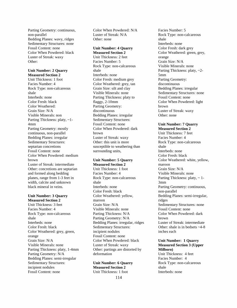
114
Parting Geometry: continuous,
non-parallel
Bedding Planes: wavy, ridges
Sedimentary Structures: none
Fossil Content: none
Color When Powdered: black
Luster of Streak: waxy
Other:
Unit Number: 2 Quarry
Measured Section 2
Unit Thickness: 1 foot
Facies Number: 4
Rock Type: non-calcareous
shale
Interbeds: none
Color Fresh: black
Color Weathered:
Grain Size: N/A
Visible Minerals: non
Parting Thickness: platy, ~1-
4mm
Parting Geometry: mostly
continuous, non-parallel
Bedding Planes: irregular
Sedimentary Structures:
septarian concretions
Fossil Content: none
Color When Powdered: medium
brown
Luster of Streak: intermediate
Other: concretions are septarian
and formed along bedding
planes, range from 1-3 feet in
width, calcite and unknown
black mineral in veins.
Unit Number: 3 Quarry
Measured Section 2
Unit Thickness: 3 feet
Facies Number: 4
Rock Type: non-calcareous
shale
Interbeds: none
Color Fresh: black
Color Weathered: grey, green,
orange
Grain Size: N/A
Visible Minerals: none
Parting Thickness: platy, 1-4mm
Parting Geometry: N/A
Bedding Planes: semi-irregular
Sedimentary Structures:
incipient nodules
Fossil Content: none
Color When Powdered: N/A
Luster of Streak: N/A
Other: none
Unit Number: 4 Quarry
Measured Section 2
Unit Thickness: 2 feet
Facies Number: 5
Rock Type: non-calcareous
shale
Interbeds: none
Color Fresh: medium grey
Color Weathered: grey, tan
Grain Size: silt and clay
Visible Minerals: none
Parting Thickness: platy to
flaggy, 2-10mm
Parting Geometry:
discontinuous
Bedding Planes: irregular
Sedimentary Structures:
Fossil Content: none
Color When Powdered: dark
brown
Luster of Streak: waxy
Other: this unit is more
susceptible to weathering than
surrounding units,
Unit Number: 5 Quarry
Measured Section 2
Unit Thickness: 1 foot
Facies Number: 4
Rock Type: non-calcareous
shale
Interbeds: none
Color Fresh: black
Color Weathered: yellow,
maroon
Grain Size: N/A
Visible Minerals: none
Parting Thickness: N/A
Parting Geometry: N/A
Bedding Planes: irregular, ridges
Sedimentary Structures:
incipient nodules
Fossil Content: none
Color When Powdered: black
Luster of Streak: waxy
Other: partings are distorted by
deformation
Unit Number: 6 Quarry
Measured Section 2
Unit Thickness: 1 foot
Facies Number: 5
Rock Type: non-calcareous
shale
Interbeds: none
Color Fresh: dark grey
Color Weathered: green, grey,
orange
Grain Size: N/A
Visible Minerals: none
Parting Thickness: platy, ~2-
5mm
Parting Geometry:
discontinuous
Bedding Planes: irregular
Sedimentary Structures: none
Fossil Content: none
Color When Powdered: light
brown
Luster of Streak: waxy
Other: none
Unit Number: 7 Quarry
Measured Section 2
Unit Thickness: 7 feet
Facies Number: 4
Rock Type: non-calcareous
shale
Interbeds: none
Color Fresh: black
Color Weathered: white, yellow,
maroon
Grain Size: N/A
Visible Minerals: none
Parting Thickness: platy, ~ 1-
3mm
Parting Geometry: continuous,
non-parallel
Bedding Planes: semi-irregular,
ridges
Sedimentary Structures: none
Fossil Content: none
Color When Powdered: dark
brown
Luster of Streak: intermediate
Other: shale is in bedsets ~4-8
inches each
Unit Number: 1 Quarry
Measured Section 3 (Upper
Milboro)
Unit Thickness: 4 feet
Facies Number: 4
Rock Type: non-calcareous
shale
Interbeds: none
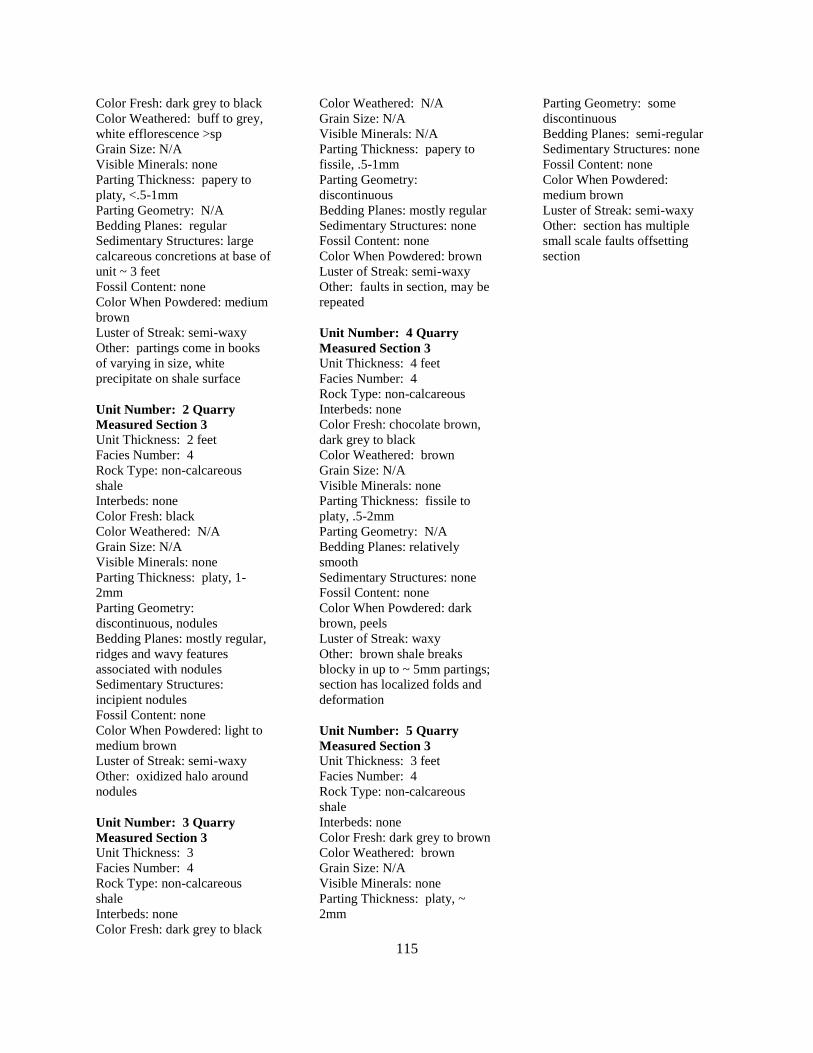
115
Color Fresh: dark grey to black
Color Weathered: buff to grey,
white efflorescence >sp
Grain Size: N/A
Visible Minerals: none
Parting Thickness: papery to
platy, <.5-1mm
Parting Geometry: N/A
Bedding Planes: regular
Sedimentary Structures: large
calcareous concretions at base of
unit ~ 3 feet
Fossil Content: none
Color When Powdered: medium
brown
Luster of Streak: semi-waxy
Other: partings come in books
of varying in size, white
precipitate on shale surface
Unit Number: 2 Quarry
Measured Section 3
Unit Thickness: 2 feet
Facies Number: 4
Rock Type: non-calcareous
shale
Interbeds: none
Color Fresh: black
Color Weathered: N/A
Grain Size: N/A
Visible Minerals: none
Parting Thickness: platy, 1-
2mm
Parting Geometry:
discontinuous, nodules
Bedding Planes: mostly regular,
ridges and wavy features
associated with nodules
Sedimentary Structures:
incipient nodules
Fossil Content: none
Color When Powdered: light to
medium brown
Luster of Streak: semi-waxy
Other: oxidized halo around
nodules
Unit Number: 3 Quarry
Measured Section 3
Unit Thickness: 3
Facies Number: 4
Rock Type: non-calcareous
shale
Interbeds: none
Color Fresh: dark grey to black
Color Weathered: N/A
Grain Size: N/A
Visible Minerals: N/A
Parting Thickness: papery to
fissile, .5-1mm
Parting Geometry:
discontinuous
Bedding Planes: mostly regular
Sedimentary Structures: none
Fossil Content: none
Color When Powdered: brown
Luster of Streak: semi-waxy
Other: faults in section, may be
repeated
Unit Number: 4 Quarry
Measured Section 3
Unit Thickness: 4 feet
Facies Number: 4
Rock Type: non-calcareous
Interbeds: none
Color Fresh: chocolate brown,
dark grey to black
Color Weathered: brown
Grain Size: N/A
Visible Minerals: none
Parting Thickness: fissile to
platy, .5-2mm
Parting Geometry: N/A
Bedding Planes: relatively
smooth
Sedimentary Structures: none
Fossil Content: none
Color When Powdered: dark
brown, peels
Luster of Streak: waxy
Other: brown shale breaks
blocky in up to ~ 5mm partings;
section has localized folds and
deformation
Unit Number: 5 Quarry
Measured Section 3
Unit Thickness: 3 feet
Facies Number: 4
Rock Type: non-calcareous
shale
Interbeds: none
Color Fresh: dark grey to brown
Color Weathered: brown
Grain Size: N/A
Visible Minerals: none
Parting Thickness: platy, ~
2mm
Parting Geometry: some
discontinuous
Bedding Planes: semi-regular
Sedimentary Structures: none
Fossil Content: none
Color When Powdered:
medium brown
Luster of Streak: semi-waxy
Other: section has multiple
small scale faults offsetting
section
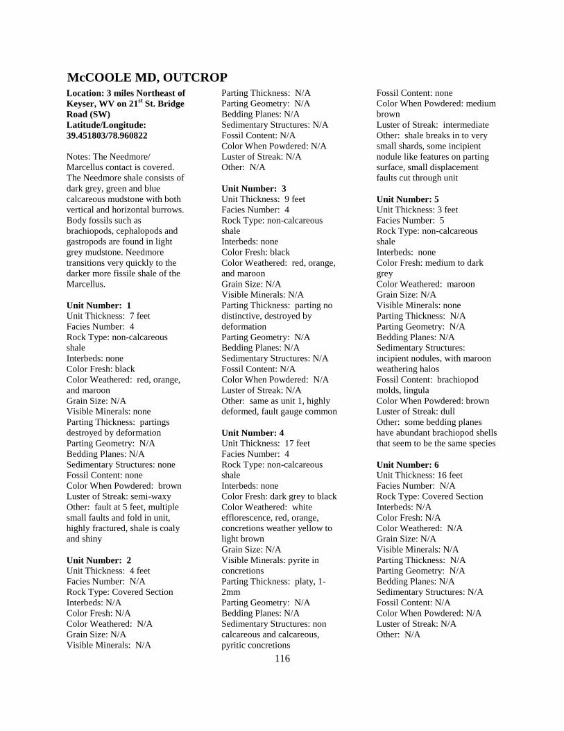
116
Location: 3 miles Northeast of
Keyser, WV on 21st St. Bridge
Road (SW)
Latitude/Longitude:
39.451803/78.960822
Notes: The Needmore/
Marcellus contact is covered.
The Needmore shale consists of
dark grey, green and blue
calcareous mudstone with both
vertical and horizontal burrows.
Body fossils such as
brachiopods, cephalopods and
gastropods are found in light
grey mudstone. Needmore
transitions very quickly to the
darker more fissile shale of the
Marcellus.
Unit Number: 1
Unit Thickness: 7 feet
Facies Number: 4
Rock Type: non-calcareous
shale
Interbeds: none
Color Fresh: black
Color Weathered: red, orange,
and maroon
Grain Size: N/A
Visible Minerals: none
Parting Thickness: partings
destroyed by deformation
Parting Geometry: N/A
Bedding Planes: N/A
Sedimentary Structures: none
Fossil Content: none
Color When Powdered: brown
Luster of Streak: semi-waxy
Other: fault at 5 feet, multiple
small faults and fold in unit,
highly fractured, shale is coaly
and shiny
Unit Number: 2
Unit Thickness: 4 feet
Facies Number: N/A
Rock Type: Covered Section
Interbeds: N/A
Color Fresh: N/A
Color Weathered: N/A
Grain Size: N/A
Visible Minerals: N/A
Parting Thickness: N/A
Parting Geometry: N/A
Bedding Planes: N/A
Sedimentary Structures: N/A
Fossil Content: N/A
Color When Powdered: N/A
Luster of Streak: N/A
Other: N/A
Unit Number: 3
Unit Thickness: 9 feet
Facies Number: 4
Rock Type: non-calcareous
shale
Interbeds: none
Color Fresh: black
Color Weathered: red, orange,
and maroon
Grain Size: N/A
Visible Minerals: N/A
Parting Thickness: parting no
distinctive, destroyed by
deformation
Parting Geometry: N/A
Bedding Planes: N/A
Sedimentary Structures: N/A
Fossil Content: N/A
Color When Powdered: N/A
Luster of Streak: N/A
Other: same as unit 1, highly
deformed, fault gauge common
Unit Number: 4
Unit Thickness: 17 feet
Facies Number: 4
Rock Type: non-calcareous
shale
Interbeds: none
Color Fresh: dark grey to black
Color Weathered: white
efflorescence, red, orange,
concretions weather yellow to
light brown
Grain Size: N/A
Visible Minerals: pyrite in
concretions
Parting Thickness: platy, 1-
2mm
Parting Geometry: N/A
Bedding Planes: N/A
Sedimentary Structures: non
calcareous and calcareous,
pyritic concretions
Fossil Content: none
Color When Powdered: medium
brown
Luster of Streak: intermediate
Other: shale breaks in to very
small shards, some incipient
nodule like features on parting
surface, small displacement
faults cut through unit
Unit Number: 5
Unit Thickness: 3 feet
Facies Number: 5
Rock Type: non-calcareous
shale
Interbeds: none
Color Fresh: medium to dark
grey
Color Weathered: maroon
Grain Size: N/A
Visible Minerals: none
Parting Thickness: N/A
Parting Geometry: N/A
Bedding Planes: N/A
Sedimentary Structures:
incipient nodules, with maroon
weathering halos
Fossil Content: brachiopod
molds, lingula
Color When Powdered: brown
Luster of Streak: dull
Other: some bedding planes
have abundant brachiopod shells
that seem to be the same species
Unit Number: 6
Unit Thickness: 16 feet
Facies Number: N/A
Rock Type: Covered Section
Interbeds: N/A
Color Fresh: N/A
Color Weathered: N/A
Grain Size: N/A
Visible Minerals: N/A
Parting Thickness: N/A
Parting Geometry: N/A
Bedding Planes: N/A
Sedimentary Structures: N/A
Fossil Content: N/A
Color When Powdered: N/A
Luster of Streak: N/A
Other: N/A
McCOOLE MD, OUTCROP
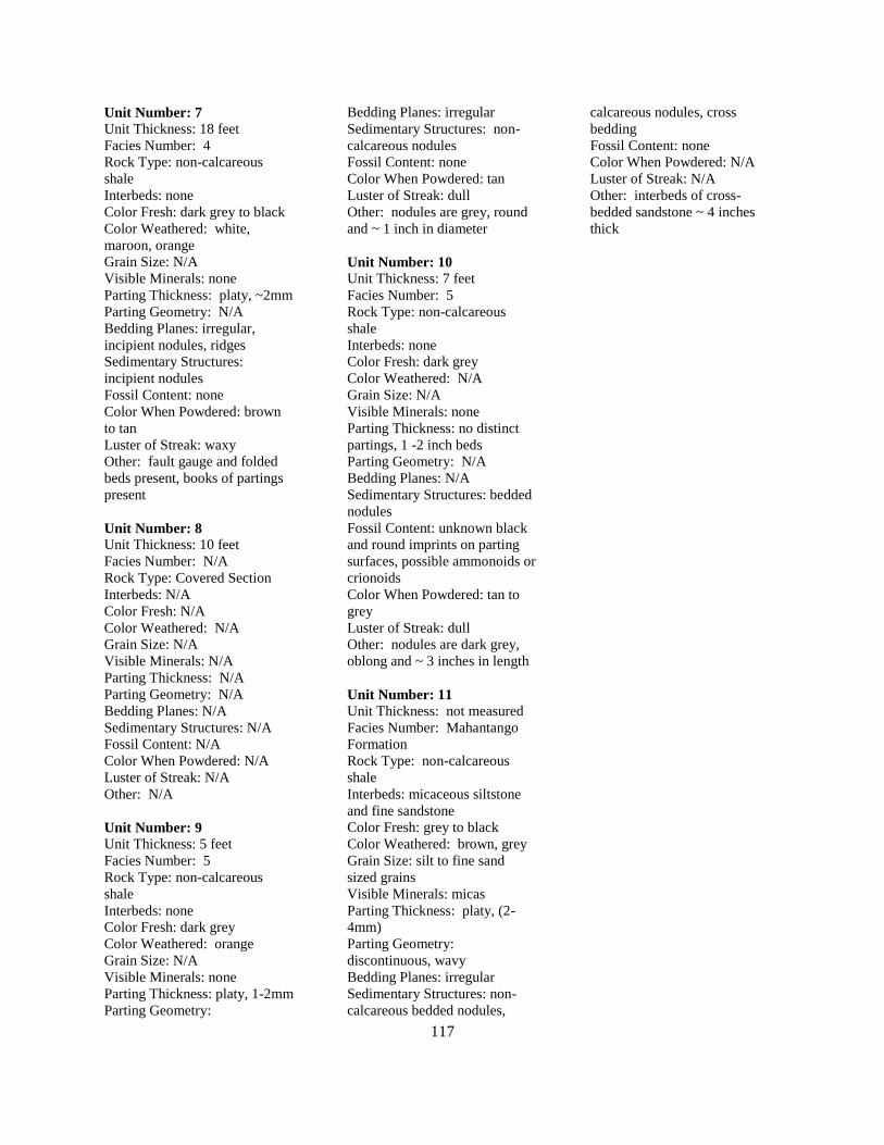
117
Unit Number: 7
Unit Thickness: 18 feet
Facies Number: 4
Rock Type: non-calcareous
shale
Interbeds: none
Color Fresh: dark grey to black
Color Weathered: white,
maroon, orange
Grain Size: N/A
Visible Minerals: none
Parting Thickness: platy, ~2mm
Parting Geometry: N/A
Bedding Planes: irregular,
incipient nodules, ridges
Sedimentary Structures:
incipient nodules
Fossil Content: none
Color When Powdered: brown
to tan
Luster of Streak: waxy
Other: fault gauge and folded
beds present, books of partings
present
Unit Number: 8
Unit Thickness: 10 feet
Facies Number: N/A
Rock Type: Covered Section
Interbeds: N/A
Color Fresh: N/A
Color Weathered: N/A
Grain Size: N/A
Visible Minerals: N/A
Parting Thickness: N/A
Parting Geometry: N/A
Bedding Planes: N/A
Sedimentary Structures: N/A
Fossil Content: N/A
Color When Powdered: N/A
Luster of Streak: N/A
Other: N/A
Unit Number: 9
Unit Thickness: 5 feet
Facies Number: 5
Rock Type: non-calcareous
shale
Interbeds: none
Color Fresh: dark grey
Color Weathered: orange
Grain Size: N/A
Visible Minerals: none
Parting Thickness: platy, 1-2mm
Parting Geometry:
Bedding Planes: irregular
Sedimentary Structures: non-
calcareous nodules
Fossil Content: none
Color When Powdered: tan
Luster of Streak: dull
Other: nodules are grey, round
and ~ 1 inch in diameter
Unit Number: 10
Unit Thickness: 7 feet
Facies Number: 5
Rock Type: non-calcareous
shale
Interbeds: none
Color Fresh: dark grey
Color Weathered: N/A
Grain Size: N/A
Visible Minerals: none
Parting Thickness: no distinct
partings, 1 -2 inch beds
Parting Geometry: N/A
Bedding Planes: N/A
Sedimentary Structures: bedded
nodules
Fossil Content: unknown black
and round imprints on parting
surfaces, possible ammonoids or
crionoids
Color When Powdered: tan to
grey
Luster of Streak: dull
Other: nodules are dark grey,
oblong and ~ 3 inches in length
Unit Number: 11
Unit Thickness: not measured
Facies Number: Mahantango
Formation
Rock Type: non-calcareous
shale
Interbeds: micaceous siltstone
and fine sandstone
Color Fresh: grey to black
Color Weathered: brown, grey
Grain Size: silt to fine sand
sized grains
Visible Minerals: micas
Parting Thickness: platy, (2-
4mm)
Parting Geometry:
discontinuous, wavy
Bedding Planes: irregular
Sedimentary Structures: non-
calcareous bedded nodules,
calcareous nodules, cross
bedding
Fossil Content: none
Color When Powdered: N/A
Luster of Streak: N/A
Other: interbeds of cross-
bedded sandstone ~ 4 inches
thick
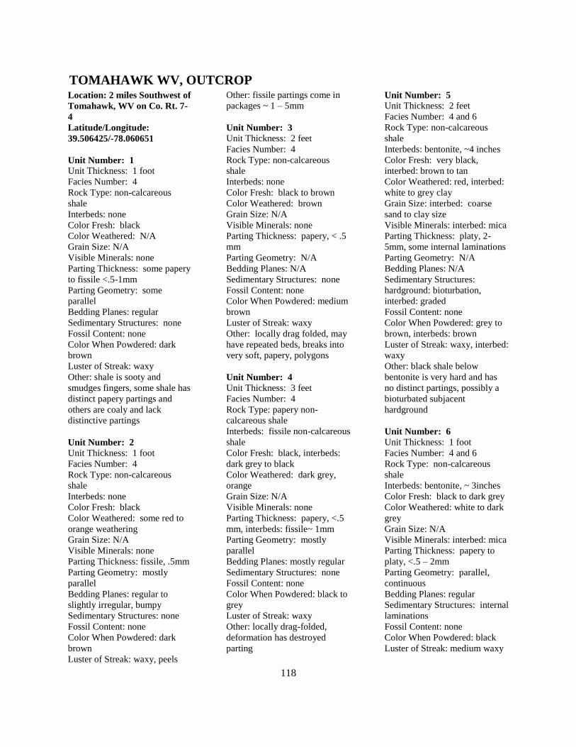
118
Location: 2 miles Southwest of
Tomahawk, WV on Co. Rt. 7-
4
Latitude/Longitude:
39.506425/-78.060651
Unit Number: 1
Unit Thickness: 1 foot
Facies Number: 4
Rock Type: non-calcareous
shale
Interbeds: none
Color Fresh: black
Color Weathered: N/A
Grain Size: N/A
Visible Minerals: none
Parting Thickness: some papery
to fissile <.5-1mm
Parting Geometry: some
parallel
Bedding Planes: regular
Sedimentary Structures: none
Fossil Content: none
Color When Powdered: dark
brown
Luster of Streak: waxy
Other: shale is sooty and
smudges fingers, some shale has
distinct papery partings and
others are coaly and lack
distinctive partings
Unit Number: 2
Unit Thickness: 1 foot
Facies Number: 4
Rock Type: non-calcareous
shale
Interbeds: none
Color Fresh: black
Color Weathered: some red to
orange weathering
Grain Size: N/A
Visible Minerals: none
Parting Thickness: fissile, .5mm
Parting Geometry: mostly
parallel
Bedding Planes: regular to
slightly irregular, bumpy
Sedimentary Structures: none
Fossil Content: none
Color When Powdered: dark
brown
Luster of Streak: waxy, peels
Other: fissile partings come in
packages ~ 1 – 5mm
Unit Number: 3
Unit Thickness: 2 feet
Facies Number: 4
Rock Type: non-calcareous
shale
Interbeds: none
Color Fresh: black to brown
Color Weathered: brown
Grain Size: N/A
Visible Minerals: none
Parting Thickness: papery, < .5
mm
Parting Geometry: N/A
Bedding Planes: N/A
Sedimentary Structures: none
Fossil Content: none
Color When Powdered: medium
brown
Luster of Streak: waxy
Other: locally drag folded, may
have repeated beds, breaks into
very soft, papery, polygons
Unit Number: 4
Unit Thickness: 3 feet
Facies Number: 4
Rock Type: papery non-
calcareous shale
Interbeds: fissile non-calcareous
shale
Color Fresh: black, interbeds:
dark grey to black
Color Weathered: dark grey,
orange
Grain Size: N/A
Visible Minerals: none
Parting Thickness: papery, <.5
mm, interbeds: fissile~ 1mm
Parting Geometry: mostly
parallel
Bedding Planes: mostly regular
Sedimentary Structures: none
Fossil Content: none
Color When Powdered: black to
grey
Luster of Streak: waxy
Other: locally drag-folded,
deformation has destroyed
parting
Unit Number: 5
Unit Thickness: 2 feet
Facies Number: 4 and 6
Rock Type: non-calcareous
shale
Interbeds: bentonite, ~4 inches
Color Fresh: very black,
interbed: brown to tan
Color Weathered: red, interbed:
white to grey clay
Grain Size: interbed: coarse
sand to clay size
Visible Minerals: interbed: mica
Parting Thickness: platy, 2-
5mm, some internal laminations
Parting Geometry: N/A
Bedding Planes: N/A
Sedimentary Structures:
hardground: bioturbation,
interbed: graded
Fossil Content: none
Color When Powdered: grey to
brown, interbeds: brown
Luster of Streak: waxy, interbed:
waxy
Other: black shale below
bentonite is very hard and has
no distinct partings, possibly a
bioturbated subjacent
hardground
Unit Number: 6
Unit Thickness: 1 foot
Facies Number: 4 and 6
Rock Type: non-calcareous
shale
Interbeds: bentonite, ~ 3inches
Color Fresh: black to dark grey
Color Weathered: white to dark
grey
Grain Size: N/A
Visible Minerals: interbed: mica
Parting Thickness: papery to
platy, <.5 – 2mm
Parting Geometry: parallel,
continuous
Bedding Planes: regular
Sedimentary Structures: internal
laminations
Fossil Content: none
Color When Powdered: black
Luster of Streak: medium waxy
TOMAHAWK WV, OUTCROP
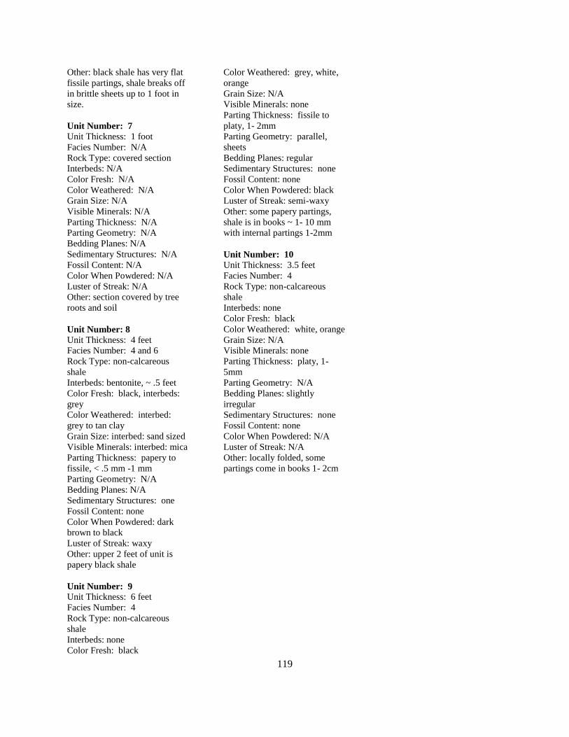
119
Other: black shale has very flat
fissile partings, shale breaks off
in brittle sheets up to 1 foot in
size.
Unit Number: 7
Unit Thickness: 1 foot
Facies Number: N/A
Rock Type: covered section
Interbeds: N/A
Color Fresh: N/A
Color Weathered: N/A
Grain Size: N/A
Visible Minerals: N/A
Parting Thickness: N/A
Parting Geometry: N/A
Bedding Planes: N/A
Sedimentary Structures: N/A
Fossil Content: N/A
Color When Powdered: N/A
Luster of Streak: N/A
Other: section covered by tree
roots and soil
Unit Number: 8
Unit Thickness: 4 feet
Facies Number: 4 and 6
Rock Type: non-calcareous
shale
Interbeds: bentonite, ~ .5 feet
Color Fresh: black, interbeds:
grey
Color Weathered: interbed:
grey to tan clay
Grain Size: interbed: sand sized
Visible Minerals: interbed: mica
Parting Thickness: papery to
fissile, < .5 mm -1 mm
Parting Geometry: N/A
Bedding Planes: N/A
Sedimentary Structures: one
Fossil Content: none
Color When Powdered: dark
brown to black
Luster of Streak: waxy
Other: upper 2 feet of unit is
papery black shale
Unit Number: 9
Unit Thickness: 6 feet
Facies Number: 4
Rock Type: non-calcareous
shale
Interbeds: none
Color Fresh: black
Color Weathered: grey, white,
orange
Grain Size: N/A
Visible Minerals: none
Parting Thickness: fissile to
platy, 1- 2mm
Parting Geometry: parallel,
sheets
Bedding Planes: regular
Sedimentary Structures: none
Fossil Content: none
Color When Powdered: black
Luster of Streak: semi-waxy
Other: some papery partings,
shale is in books ~ 1- 10 mm
with internal partings 1-2mm
Unit Number: 10
Unit Thickness: 3.5 feet
Facies Number: 4
Rock Type: non-calcareous
shale
Interbeds: none
Color Fresh: black
Color Weathered: white, orange
Grain Size: N/A
Visible Minerals: none
Parting Thickness: platy, 1-
5mm
Parting Geometry: N/A
Bedding Planes: slightly
irregular
Sedimentary Structures: none
Fossil Content: none
Color When Powdered: N/A
Luster of Streak: N/A
Other: locally folded, some
partings come in books 1- 2cm
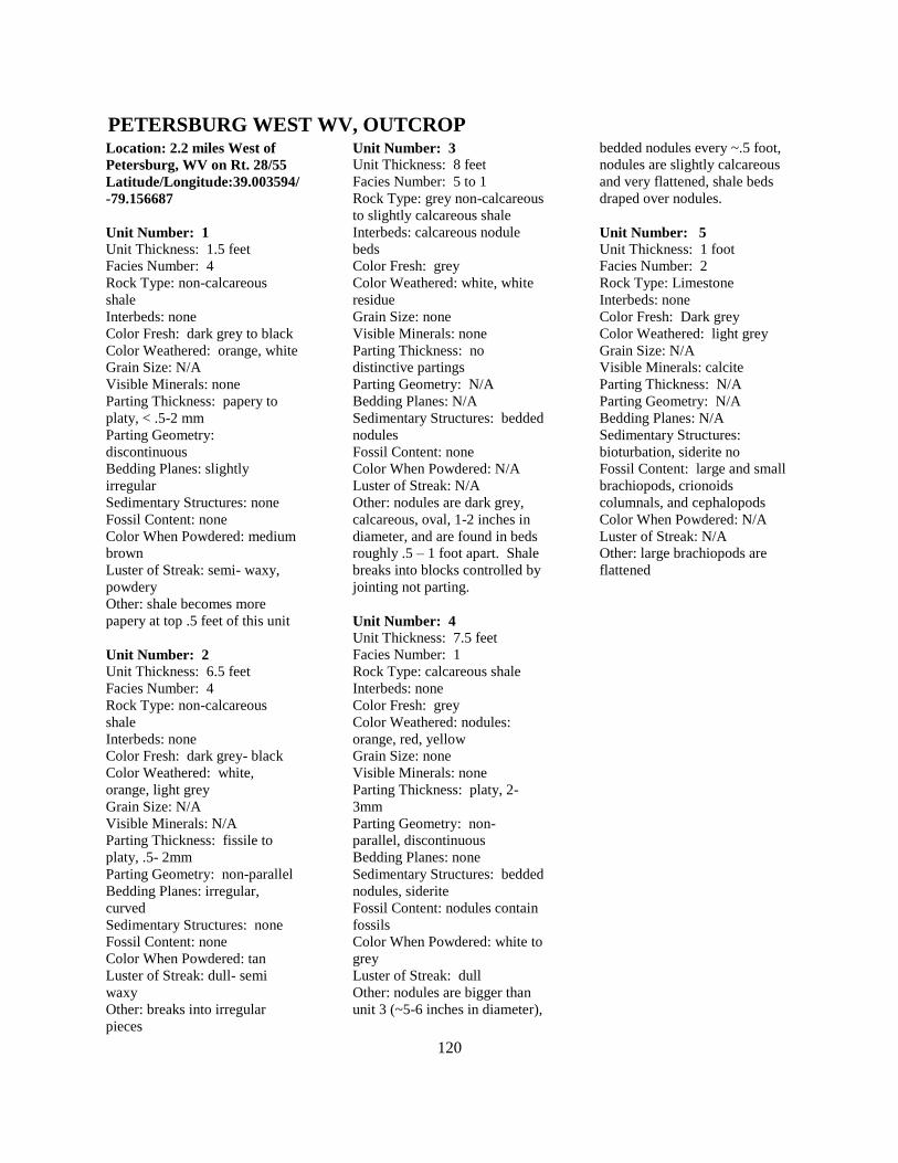
120
Location: 2.2 miles West of
Petersburg, WV on Rt. 28/55
Latitude/Longitude:39.003594/
-79.156687
Unit Number: 1
Unit Thickness: 1.5 feet
Facies Number: 4
Rock Type: non-calcareous
shale
Interbeds: none
Color Fresh: dark grey to black
Color Weathered: orange, white
Grain Size: N/A
Visible Minerals: none
Parting Thickness: papery to
platy, < .5-2 mm
Parting Geometry:
discontinuous
Bedding Planes: slightly
irregular
Sedimentary Structures: none
Fossil Content: none
Color When Powdered: medium
brown
Luster of Streak: semi- waxy,
powdery
Other: shale becomes more
papery at top .5 feet of this unit
Unit Number: 2
Unit Thickness: 6.5 feet
Facies Number: 4
Rock Type: non-calcareous
shale
Interbeds: none
Color Fresh: dark grey- black
Color Weathered: white,
orange, light grey
Grain Size: N/A
Visible Minerals: N/A
Parting Thickness: fissile to
platy, .5- 2mm
Parting Geometry: non-parallel
Bedding Planes: irregular,
curved
Sedimentary Structures: none
Fossil Content: none
Color When Powdered: tan
Luster of Streak: dull- semi
waxy
Other: breaks into irregular
pieces
Unit Number: 3
Unit Thickness: 8 feet
Facies Number: 5 to 1
Rock Type: grey non-calcareous
to slightly calcareous shale
Interbeds: calcareous nodule
beds
Color Fresh: grey
Color Weathered: white, white
residue
Grain Size: none
Visible Minerals: none
Parting Thickness: no
distinctive partings
Parting Geometry: N/A
Bedding Planes: N/A
Sedimentary Structures: bedded
nodules
Fossil Content: none
Color When Powdered: N/A
Luster of Streak: N/A
Other: nodules are dark grey,
calcareous, oval, 1-2 inches in
diameter, and are found in beds
roughly .5 – 1 foot apart. Shale
breaks into blocks controlled by
jointing not parting.
Unit Number: 4
Unit Thickness: 7.5 feet
Facies Number: 1
Rock Type: calcareous shale
Interbeds: none
Color Fresh: grey
Color Weathered: nodules:
orange, red, yellow
Grain Size: none
Visible Minerals: none
Parting Thickness: platy, 2-
3mm
Parting Geometry: non-
parallel, discontinuous
Bedding Planes: none
Sedimentary Structures: bedded
nodules, siderite
Fossil Content: nodules contain
fossils
Color When Powdered: white to
grey
Luster of Streak: dull
Other: nodules are bigger than
unit 3 (~5-6 inches in diameter),
bedded nodules every ~.5 foot,
nodules are slightly calcareous
and very flattened, shale beds
draped over nodules.
Unit Number: 5
Unit Thickness: 1 foot
Facies Number: 2
Rock Type: Limestone
Interbeds: none
Color Fresh: Dark grey
Color Weathered: light grey
Grain Size: N/A
Visible Minerals: calcite
Parting Thickness: N/A
Parting Geometry: N/A
Bedding Planes: N/A
Sedimentary Structures:
bioturbation, siderite no
Fossil Content: large and small
brachiopods, crionoids
columnals, and cephalopods
Color When Powdered: N/A
Luster of Streak: N/A
Other: large brachiopods are
flattened
PETERSBURG WEST WV, OUTCROP

111