Embed Size (px)
Citation preview
Solved
Sure Shot
CLASS XII
2015
Regd. Trade Mark No. 325406
ewY;Price
MALHOTRA BOOK DEPOTAn ISO 9001:2008 Certified Company
Plot No. 225, Industrial Area,
Patparganj,
Ph.: 22149691, 22147073
Delhi-110092
MBD House, 4587/15,
Opp. Times of India, Daryaganj,
Ph.: 23245676New Delhi-110002
MB 161, Street No. 4, Shakarpur
Ph.: 22518122, 22546557
Delhi-110092
MBD House, Gulab Bhawan, 6, Bahadur Shah Zafar Marg, New Delhi-110002
GEOGRAPHY
CBSE
SAMPLEPAPERSSAMPLESAMPLEPAPERSPAPERS
COVERS
2014
BOARD PAPERS
(SOLVED)
225.00
K
K
OUR ADDRESSES IN INDIA� New Delhi : MBD House, Gulab Bhawan, 6, Bahadur Shah Zafar Marg Ph. 23317931, 23318301� Mumbai : A-683, T.T.C. Industrial Area, M.I.D.C. Off. Thane-Belapur Road, Navi Mumbai
Ph. 32996410, 27780821, 8691053365� Chennai : No. 26 B/2 SIDCO Estate, North Phase, Pattravakkam Ambattur Industrial Estate, Ambattur
Ph. 26359376, 26242350� Chennai : 15A, Ground Floor, Tiruvenkatapuram 1st Street, Near Nungambakkam
Railway Station, Choolaimedu Ph. 23741471� Kolkata : Satyam Building, 46-D, Rafi Ahmed Kidwai Marg Ph. 22296863, 22161670� Jalandhar City : MBD House, Railway Road Ph. 2458388, 2459046, 2455663� Bengaluru : 124/31, 1st Main, Industrial Town (Near Chowdeshwari Kalyan Mantap),
West of Chord Road, Rajajinagar Ph. 23103329, 23104667� Hyderabad : 3-4-492, Varun Towers, Barkatpura Ph. 27564788, 9985820001� Ernakulam : Surabhi Building, South Janatha Road, Palarivattom Ph. 2338107, 2347371� Pune : Kaul Building No. 2, IInd Floor, Flat ‘C’, Guru Nanak Nagar, Shankar Sheth Road
Ph. 26431413, 26435071� Nagpur : Near N.I.T. Swimming Pool, North Ambazari Road, Ambazari Layout
Ph. 2248104, 2248106, 2248649, 2245648� Ahmedabad : Godown No. 10, Vedant Prabha Estate, Opp. ONGC Pumping Station,
Sarkhej Sanand Road, Sarkhej Ph. 26890336� Cuttack : Badam Bari, Link Road Ph. 2367277, 2367279, 2313013� Guwahati : Chancellor Commercial, Hem Baruah Road, Paan Bazar Ph. 2510492, 2731008� Lucknow : 173/15, Dr. B. N. Verma Road, Old 30 Kutchery Road Ph. 4010992, 4010993� Patna : Ist Floor, Annapurna Complex, Naya Tola Ph. 2672732, 2686994, 2662472� Bhopal : Plot No. 137, 138, 139, Sector-1, Special Industrial Area, Govindpura Ph. 2581540, 2601535� Jabalpur : 840, Palash Chamber, Malviya Chowk Ph. 2405854� Goa : H. No. 932, Plot No. 66, Kranti Nagar (Behind Azad Bhawan), Alto Porvorim, Bardez
Ph. 2413982, 2414394� Jaipur : G-11, Kartarpura Industrial Area, Baees Godown Ph. 2210158, 2210159� Raipur : Behind Kailash Provision Store, Ravi Nagar Ph. 2445320, 2422542� Karnal : Plot No. 203, Sector-3, HSIDC, Near Namaste Chowk, Opp. New World Ph. 2220006, 2220009� Shimla (H.P.) : C-89, Sector-I, New Shimla-9 Ph. 2670221,2670618� Jammu (J&K) : MBD Office, 48 Gurjjar Colony, C/o Gurjar Desh Charitable Trust, N.H. Bye Pass Road
Ph. 2467376, 9419104035� Ranchi (Jharkhand) : Shivani Complex, 2nd Floor, Jyoti Sangam Lane, Upper Bazar Ph. 9431257111� Sahibabad (U.P.) : B-9 & 10, Site IV, Industrial Area Ph. 3100045, 2896939� Dehradun (Uttarakhand) : Plot No. 37, Bhagirathipuram, Niranjanpur, GMS Road Ph. 2520360, 2107214
DELHI LOCAL OFFICES :� Delhi (Shakarpur) : MB 161, Street No. 4 Ph. 22546557, 22518122� Delhi (Daryaganj) : MBD House, 4587/15, Opp. Times of India Ph. 23245676� Delhi (Patparganj) : Plot No. 225, Industrial Area Ph. 22149691, 22147073
Notes to the Maps : The external boundary and coastline of India on all the maps included in this book agree with the Record/Master Copy certified by the Surveyor General of India, Dehradun vide Letter No. TB 326/62–A–3/A, dated 24/01/2007. Outlineof the other maps included in the book are based upon Survey of India maps printed in 2007.
© Government of India copyright 2007.
We are committed to serve students with best of our knowledge and resources. We have taken utmost care and attention whileediting and printing this book but we would beg to state that Authors and Publishers should not be held responsible for unintentionalmistake that might have crept in. However, errors brought to our notice shall be gratefully acknowledged and attended to.
© All rights reserved. No part of this publication may be reproduced, stored in a retrieval system, or transmitted in any form or byany means, electronic, mechanical, photocopying, recording, or otherwise without the prior written permission of the publisher.Any breach will entail legal action and prosecution without further notice.
Published by : MALHOTRA BOOK DEPOTMBD House, Railway Road, Jalandhar
Printed at : M. GULAB SINGH & SONS (P) LTD.B-5/14, Site IV, Industrial Area, Sahibabad (U.P.)
Address-page.p65 10/7/2014, 6:57 PM1
Black
(i)
K
K
GEOGRAPHYCLASS–XII
One Theory Paper 3 Hours 70 Marks
A. Fundamentals of Human Geography 30 Marks
Unit 1 : Human Geography
Unit 2 : People
Unit 3 : Human Activities
Unit 4 : Transport, Communication & Trade
Unit 5 : Human Settlements
Map Work 5
B. India : People and Economy 30 Marks
Unit 6 : People
Unit 7 : Human Settlements
Unit 8 : Resources and Development
Unit 9 : Transport, Communication and International Trade
Unit 10 : Geographical Perspective on selected issues and problems
Map Work 5
C. Practical Work 30 Marks
Unit 1 : Processing of Data and Thematic Mapping 15
Unit 2 : Field study or Spatial Information Technology 10
Unit 3 : Practical Record Book and Viva Voce 5
Part A. Fundamentals of Human Geography (90 Periods) 35 Marks
Unit 1 : Human Geography : Nature and Scope 5 Periods
Unit 2 : People 18 Periods
l Population– distribution, density and growth.
l Population change-spatial patterns and structure; determinants of
population change.
l Age-sex ratio; rural-urban composition.
l Human development–concept; selected indicators, international
comparisons.
Unit 3 : Human Activities 28 Periods
l Primary activities–concept and changing trends; gathering, pastoral, mining,
subsistence agriculture; modern agriculture, people engaged in agricultural
and allied activities – some examples from selected countries.
l Secondary activities–concept; manufacturing : types–household, small scale,
large scale; agro based and mineral based industries; people engaged in
secondary activities – some examples from selected countries.
l Tertiary activities–concept; trade, transport and tourism; services; people
engaged in tertiary activities – some examples from selected countries.
SYLLABUS
Syllabus New.p65 10/6/2014, 6:20 PM1
(ii)
K
K
l Quaternary activities – concept; people engaged in quaternary activities –
case study from selected countries.
Unit 4 : Transport, Communication and Trade 23 Periods
l Land transport–roads, railways; trans-continental railways.
l Water transport–inland waterways; major ocean routes.
l Air transport–Intercontinental air routes.
l Oil and gas pipelines.
l Satellite communication and cyber space – Importance and usage for
geographical information; use of GPS.
l International trade – Bases and changing patterns; ports as gateways of
international trade, role of WTO in International trade.
l Ocean: National rights and international treaties.
Unit 5 : Human Settlements 10 Periods
l Settlement types – rural and urban; morphology of cities (case study);
distribution of mega cities; problems of human settlements in developing
countries.
Map Work on identification of features based on 1 – 5 units on the
outline/Physical/Political map of World. 5 Periods
Part B. India : People and Economy (90 Periods)
Unit 6 : People 15 Periods
l Population – distribution, density and growth; composition of population
– linguistic; religious; sex, rural-urban and occupational – regional
variations in growth of population.
l Migration : international, national-causes and consequences.
l Human development – selected indicators and regional patterns.
l Population, environment and development.
Unit 7 : Human Settlements 10 Periods
l Rural settlements–types and distribution.
l Urban settlements–types, distribution and functional classification.
Unit 8 : Resources and Development 30 Periods
l Land resources–general land use; agricultural land use, Geographical
conditions and distribution of major crops (Wheat, Rice, Tea, Coffee,
Cotton, Jute, Sugarcane and Rubber), agricultural development and
problems.
l Water resources – availability and utilization – irrigation, domestic,
industrial and other uses; scarcity of water and conservation methods –
rain water harvesting and watershed management (one case study related
with participatory watershed management to be introduced).
l Mineral and energy resources – distribution of metallic (Iron-ore, Copper,
Bauxite, Manganese); non-metallic (Mica, Salt) minerals; conventional
(Coal, Petroleum, Natural gas and Hydroelectricity) and non-conventional
energy sources (solar, wind, biogas) and conservation.
l Industries–types, factors of industrial location; distribution and changing
pattern of selected industries–iron and steel, cotton textiles, sugar,
Syllabus New.p65 10/6/2014, 6:20 PM2
(iii)
K
K
petrochemicals and knowledge based industries; impact of liberalization,
privatisation and globalisation on industrial location; industrial clusters.
l Planning in India – target group area planning (case study); idea of
sustainable development (case study).
Unit 9 : Transport, Communication and International Trade 15 Periods
l Transport and communication–roads, railways, waterways and airways:
oil and gas pipelines; Geographical information and communication
network.
l International trade – changing pattern of India’s foreign trade; sea ports
and their hinterland and airports.
Unit 10 : Geographical Perspective on Selected Issues and Problems
(One case study to be introduced for each topic) 15 Periods
l Environmental pollution; urban-waste disposal.
l Urbanisation, rural-urban migration; problems of slums.
l Land degradation.
Map work on locating and lebelling of features based on above
units on outline Political Map of India. 5 Marks
Part C. Practical Work (40 Periods)
Unit 1 : Processing of Data and Thematic Mapping 25 Periods
l Type and Sources of data: Primary, secondary and other sources.
l Tabulating and processing of data; calculation of averages, measures of
central tendency, deviation and rank correlation.
l Representation of data–construction of diagrams; bars, circles and
flowchart; thematic maps; construction of dot; choropleth and isopleth
maps.
l Data analysis and generation of diagrams, graphs and other visual
diagrams using computers.
Unit 2 : Field Study or Spatial Information Technology 15 Periods
Field visit and study : map orientation, observation and preparation of
sketch; survey on any one of the local concerns; pollution, ground water
changes, land use and land-use changes, poverty, energy issues, soil
degradation, impact of floods and drought, catchment area of school, Market
survey and Household survey (any one topic of local concern may be taken
up for the study; observation and questionnaire survey may be adopted
for the data collection; collected data may be tabulated and analysed with
diagrams and maps.) Students can be given different topics to get more
insight into various problems of society.
Or
Spatial Information Technology
Introduction to GIS; hardware requirements and software modules; data
formats; raster and vector data, data input, editing and topology building;
data analysis; overlay and buffer.
Syllabus New.p65 10/6/2014, 6:20 PM3
(iv)
K
K
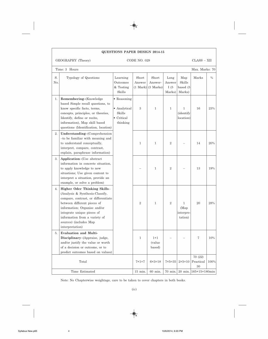
QUESTIONS PAPER DESIGN 2014-15
GEOGRAPHY (Theory) CODE NO. 029 CLASS – XII
Time: 3 Hours Max. Marks: 70
S. Typology of Questions Learning Short Short Long Map Marks %
No. Outcomes Answer Answer- Answer Skills
& Testing (1 Mark) (3 Marks) I (5 based (5
Skills Marks) Marks)
1. Remembering–(Knowledge • Reasoning
based Simple recall questions, to
know specific facts, terms, • Analytical 3 1 1 1 16 23%
concepts, principles, or theories, Skills (identify
Identify, define or recite, • Critical location)
information), Map skill based thinking
questions (Identification, location)
2. Understanding–(Comprehension
–to be familiar with meaning and
to understand conceptually, 1 1 2 – 14 20%
interpret, compare, contrast,
explain, paraphrase information)
3. Application–(Use abstract
information in concrete situation,
to apply knowledge to new – 1 2 – 13 19%
situations; Use given content to
interpret a situation, provide an
example, or solve a problem)
4. Higher Oder Thinking Skills–
(Analysis & Synthesis-Classify,
compare, contrast, or differentiate
between different pieces of 2 1 2 1 20 28%
information; Organise and/or (Map
integrate unique pieces of interpre-
information from a variety of tation)
sources) (includes Map
interpretation)
5. Evaluation and Multi-
Disciplinary–(Appraise, judge, 1 1+1 – – 7 10%
and/or justify the value or worth (value
of a decision or outcome, or to based)
predict outcomes based on values)
70 (22)
Total 7×1=7 6×3=18 7×5=35 2×5=10 Practical 100%
30
Time Estimated 15 min. 60 min. 70 min. 20 min. 165+15=180min
Note: No Chapterwise weightage, care to be taken to cover chapters in both books.
Syllabus New.p65 10/6/2014, 6:20 PM4
K
K
CONTENTS
CBSE Question Papers - 2014 Delhi (Solved) 1–12
CBSE Question Papers - 2014 Outside Delhi (Solved) 13–22
CBSE Question Papers - 2013 Delhi (Solved) 1–11
CBSE Question Papers - 2013 Outside Delhi (Solved) 12–20
Sample Question Paper (Solved) S-1–S-11
Based on the latest guidelines issued by CBSE
� Chapterwise Important Examination Style Questions (Solved)
Section A – Fundamentals of Human Geography
1. Human Geography : Nature and Scope 2–9
2. The World Population 10–22
3. Population Composition 23–28
4. Human Development 29–36
5. Primary Activities 37–46
6. Secondary Activities 47–56
7. Tertiary and Quaternary Activities 57–64
8. Transport and Communication 65–75
9. International Trade 76–86
10. Human Settlements 87–99
Section B – India : People and Economy
1. Population : Distribution, Density, Growth and Composition 101–119
2. Migration : Types, Causes and Consequences 120–125
3. Human Development 126–133
4. Human Settlements 134–139
5. Land Resources and Agriculture 140–156
2-Contents (Geography-XII-E).p65 10/7/2014, 12:39 PM1
K
K
6. Water Resources 157–164
7. Mineral and Energy Resources 165–173
8. Manufacturing 174–187
9. Planning and Sustainable Development in Indian Context 188–196
10. Transport and Communication 197–207
11. International Trade 208–214
12. Geographical Perspective on Selected Issues and Problems 215–223
� Value Based Questions 224–234
Model Question Papers For Practice M-1–M-33
Model Question Paper–1 1–4
Model Question Paper–2 5–7
Model Question Paper–3 8–10
Model Question Paper–4 11–13
Model Question Paper–5 14–16
Model Question Paper–6 17–19
Model Question Paper–7 20–22
Model Question Paper–8 23–26
Model Question Paper–9 27–29
Model Question Paper–10 30–33
2-Contents (Geography-XII-E).p65 10/7/2014, 12:39 PM2
K
K
1
CBSE QUESTION PAPERS – 2014 (Solved)
GEOGRAPHY (THEORY)–XII
(DELHI)
SET – I
Time Allowed: 3 Hours
Max. Marks: 70
General Instructions:
(i) There are 26 questions in all.
(ii) All questions are compulsory.
(iii) Marks for each question are indicated against it.
(iv) Question numbers 1 to 10 are Very Short Answer Questions carrying 1 mark each.Answer to each of these questions should not exceed 20 words.
(v) Question numbers 11 to 20 are Short Answer Questions carrying 3 marks each. Out ofwhich one question is a value-based question. Answer to each of these questions shouldnot exceed 80 words.
(vi) Question numbers 21 to 25 are Long Answer Questions of 5 marks each. Answer to eachof these questions should not exceed 150 words.
(vii) Question number 26 is related to identification or locating and labelling of geographicalfeatures on maps.
(viii) Outline maps of the World and India provided to you must be attached within youranswer-book.
(ix) Use of templates or stencils for drawing outline maps is allowed.
Q. 1. Define the term ‘Quaternary activities’. 1
Ans. Knowledge-based activities are called Quaternary activities. These involvespecialised knowledge, technical skills and administrative skills.
Q. 2. Give the meaning of 'digital divide'. 1
Ans. The divide between the developed countries and developing countries is calleddigital divide.
Q. 3. Name the seaports on each end of Suez Canal. 1
Ans. (a) Port Said on Northern end.
(b) Port Suez on Southern end.
Q. 4. Define the term ‘road density’. 1
Ans. Road density is the length of roads per 100 km of area.
Q. 5. Give any two examples of ancient towns of India. 1
Ans. Varanasi and Allahabad.
Q. 6. Name the country which is the largest trading partner of India. 1
Ans. U.S.A.
Sample Paper (Solved) Geography-E.p65 10/7/2014, 5:20 PM1
2 MBD SURE SHOT SAMPLE PAPER GEOGRAPHY (XII C.B.S.E.)
K
K
Q. 7. Name the seaport which was constructed to reduce the congestion at Kolkata
Port. 1
Ans. Haldia Port.
Q. 8. Name the major seaport which was developed just after independence on the
Western Coast of India. 1
Ans. Kandla Port.
Q. 9. What is truck farming ? 1
Ans. The growing of fruits and vegetables for market is called truck farming.
Q. 10. Mention the root cause of 'acid rains'. 1
Ans. Sulphur emitted from factories causes acid rains.
Q. 11. 'There is mutual interaction between the elements of Physical Geography and
Human Geography.' Support the statement with suitable examples. 3×1=3
Ans. The earth comprises two major components–Physical and human. The two elements
mutually interact. Physical elements include landforms, soil, climate, water, wildlife and
natural vegetation. The Physical Geography is the study of these physical elements such as
environment, minerals and atmosphere. Human Geography is the study of human beings
or human population or demography and things or activities done by humans. Houses,
villages, cities, rail-road network, industries, etc., have been created by human beings.
Human beings interact with their physical environment with the help of technology. Man
depends upon 'Mother nature' for resources. The physical elements are important for
humans to stay alive as well as to perform economic activities, etc. Also human are necessary
to extract these physical gifts to make resources, otherwise, they would remain unexploited.
Sometimes, human beings over-utilize the natural resources and affect the physical
environment causing irreparable loss.
Q. 12. Describe any three characteristics of ‘Household industries.’ 3×1=3
Ans. Characteristics of household industries:
(i) It is the smallest manufacturing unit. They use simple tools. The scale of operation
is small.
(ii) The craftspersons or artisans produce everyday goods in their homes with the help
of their family members.
(iii) These goods are locally marketed as finished goods.
Examples: Common everyday products are foodstuffs, fabrics, mats, containers, tools,
shoes, furniture, pottery, etc.
Sample Paper (Solved) Geography-E.p65 10/7/2014, 5:20 PM2
3QUESTION PAPERS – 2014 (SOLVED)
K
K
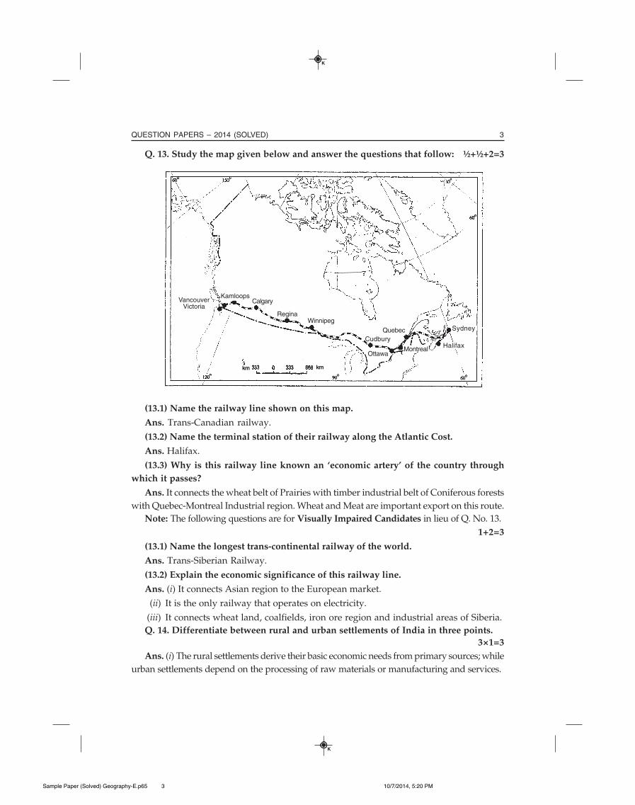
Q. 13. Study the map given below and answer the questions that follow: ½+½+2=3
(13.1) Name the railway line shown on this map.
Ans. Trans-Canadian railway.
(13.2) Name the terminal station of their railway along the Atlantic Cost.
Ans. Halifax.
(13.3) Why is this railway line known an ‘economic artery’ of the country through
which it passes?
Ans. It connects the wheat belt of Prairies with timber industrial belt of Coniferous forests
with Quebec-Montreal Industrial region. Wheat and Meat are important export on this route.
Note: The following questions are for Visually Impaired Candidates in lieu of Q. No. 13.
1+2=3
(13.1) Name the longest trans-continental railway of the world.
Ans. Trans-Siberian Railway.
(13.2) Explain the economic significance of this railway line.
Ans. (i) It connects Asian region to the European market.
(ii) It is the only railway that operates on electricity.
(iii) It connects wheat land, coalfields, iron ore region and industrial areas of Siberia.
Q. 14. Differentiate between rural and urban settlements of India in three points.
3×1=3
Ans. (i) The rural settlements derive their basic economic needs from primary sources; while
urban settlements depend on the processing of raw materials or manufacturing and services.
KamloopsCalgary
ReginaWinnipeg
Cudbury
Montreal
Sydney
Halifax
VancouverVictoria
Ottawa
Quebec
km km
Sample Paper (Solved) Geography-E.p65 10/7/2014, 5:20 PM3
4 MBD SURE SHOT SAMPLE PAPER GEOGRAPHY (XII C.B.S.E.)
K
K
(ii) Cities act as nodes of economic growth. Rural areas provide raw materials to urbanarea, while goods and services are provided by urban area to the rural areas.
(iii) The mobility of rural people is lower than that of urban people. The people of ruralareas are closely-related, while that of urban areas have formal relations. In urban areas,the way of life is complex and fast.
Q. 15. State any two characteristics each of the three distinct cropping seasons ofIndia. 3×1=3
Ans. There are three distinct cropping seasons in India–Kharif, Rabi and Zaid.
(i) Kharif Season: (a) This seasons prevails from June to September (Season of South-
West Monsoon).
(b) In the season, cultivation of tropical crops like Rice, Cotton, Maize, Jute, millets is done.
(ii) Rabi Season: (a) This season prevails from October to February.
(b) Temperate crops like Wheat, Gram, Mustard, etc., are grown in this season.
(iii) Zaid Season: (a) This is a short duration cropping seasons during summer (April to
June).
(b) Watermelons, Cucumbers, Vegetables and fodder crops are grown in this season.
Q. 16. Explain any three main characteristics of mineral resources of India. 3×1=3
Ans. Characteristics of mineral resources of India-
(i) India has a rich variety of mineral resources due to varied geological structure.
(ii) Most of valuable minerals are products of Paleozoic age. They cannot be renewed
easily and take long time to develop.
(iii) Minerals are associated with metamorphic and igneous rocks of the Peninsular India.
Q. 17. Describe any three advantages of Satellite Communication in India. 3×1=3
Ans. Advantages of Satellite Communication: Satellite communication is vital for the
country due to economic and strategic reasons:
(i) They are significant means of communication.
(ii) These can be used for the weather-forecast, monitoring of natural calamities,
surveillance of border areas.
(iii) This is useful in the management of natural resources.
Q. 18. Why is the ‘Urban Waste Disposal’ a serious problem in India? Explain any
three reasons.
Ans. Urban waste disposal is a serious problem in India-
(i) Solid waste cause health hazard and spread diseases like Typhoid, Diphtheria,
Diarrhoea, Malaria, and Cholera.
(ii) The dumping of industrial waste into rivers leads to water pollution.
(iii) Untreated wastes ferment slowly and release toxic gases into the atmosphere
including Methane.
Sample Paper (Solved) Geography-E.p65 10/7/2014, 5:20 PM4
5QUESTION PAPERS – 2014 (SOLVED)
K
K
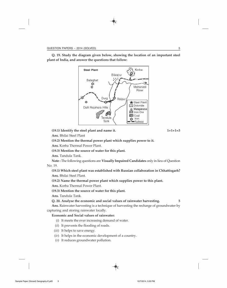
Q. 19. Study the diagram given below, showing the location of an important steel
plant of India, and answer the questions that follow:
(19.1) Identify the steel plant and name it. 1+1+1=3
Ans. Bhilai Steel Plant
(19.2) Mention the thermal power plant which supplies power to it.
Ans. Korba Thermal Power Plant.
(19.3) Mention the source of water for this plant.
Ans. Tandula Tank.
Note : The following questions are Visually Impaired Candidates only in lieu of Question
No. 19.
(19.1) Which steel plant was established with Russian collaboration in Chhattisgarh?
Ans. Bhilai Steel Plant.
(19.2) Name the thermal power plant which supplies power to this plant.
Ans. Korba Thermal Power Plant.
(19.3) Mention the source of water for this plant.
Ans. Tandula Tank.
Q. 20. Analyse the economic and social values of rainwater harvesting. 5
Ans. Rainwater harvesting is a technique of harvesting the recharge of groundwater by
capturing and storing rainwater locally.
Economic and Social values of rainwater:
(i) It meets the ever increasing demand of water.
(ii) It prevents the flooding of roads.
(iii) It helps to save energy.
(iv) It helps in the economic development of a country.
(v) It reduces groundwater pollution.
Steel Plant
Sample Paper (Solved) Geography-E.p65 10/7/2014, 5:20 PM5

6 MBD SURE SHOT SAMPLE PAPER GEOGRAPHY (XII C.B.S.E.)
K
K
(vi) It creates awareness well about conservations of water.
(vii) It reduces chances of floods and saves property.
(viii) It brings people closer as a community.
Q. 21. Explain the three components of population change in the world. Analyse the
impacts of population change. 3+2=5
Ans. Components of population change are birth, deaths and migration.
The birth of an individual increases the population as it adds a new member, whiledeath of an individual decreases the population as it subtracts the population. Migrationchanges the population leading to large exodus. In-migration or emigration populationincreases as huge chunk of population adds to the present population.
(i) High population growth leads to depletion of resources.
(ii) Economy grows if there is low population growth.
While out-migration or immigration reduces the population.
(iii) High population growth decreases economic growth.
(iv) Many problems arise due to high population growth for example, poverty,malnutrition, pollution, scarcity of food, etc.
Q. 22. Describe any two characteristics of commercial livestock rearing practiced in
the World. 5×1=5
Ans. Commercial livestock rearing:
(i) It is practised an permanent rewhes with the help of scientific methods and foddercrops.
(ii) Cattles are kept to produce meat, wool and dairy products.
(iii) It is mainly practiced in the U.S.A., Australia, New Zealand and Argentina.
(iv) The number of animals is kept according to carrying capacity of pasture.
(v) Ranches cover large areas and are sub-divided into a number of parcels.
Q. 23. Differentiate between bilateral and multilateral trade. Explain how ports are
helpful in the trade. 2+3=5
Ans. Bilateral trade is done between two countries after they enter into an agreement.
Multilateral trade is conducted with between countries. Thus, one country can tradewith a number of countries.
Ports:
(i) Ports are gateway to international trade.
(ii) Ports provide docking, loading, unloading and storage facilities for cargoes.
(iii) The port is significant in terms of the size of cargo and a number of ships it handles.
(iv) The quantities of cargo handled by a port show the level of development of itshinterland.
Sample Paper (Solved) Geography-E.p65 10/7/2014, 5:20 PM6
7QUESTION PAPERS – 2014 (SOLVED)
K
K
Q. 24. Describe any five patterns of rural settlements in the world on the basis of
forms or shapes. 5×1=5
Ans. There are five patterns of rural settlements in the world on the basis of forms orshapes. They are given below:
(a) Linear Pattern: Such patterns of settlement are located along a line, for example, road,railway line, coast and a river. It provides smooth transport and communication network.
(b) Rectangular Pattern: Such settlement patterns usually develop along the fertile plainsand the lanes cut each other at right angles. Such settlement also occurs along canal area.
(c) Circular Pattern: Such settlement patterns develop along ponds and lakes or anysimilar waterbody in a circular way. For example, the villages occur live around a pond oran inland lake. Similarly, the fishing community too lives along a waterbody in circularpattern.
(d) Star-like pattern: Such settlement patterns are seen where several roads converge ata site. Such types of settlements are found in Punjab, Haryana and Western Uttar Pradesh.
(e) T-shaped settlement Patterns develop along the confluence of rivers. Their lateralexpansion is restricted by flood plains of rivers.
(f) Y-shaped settlement patterns develop along the place where two roads convergewith the third one.
(g) Cross-shaped of Cruciform settlements develop along cross-roads and extend in allfour directions.
Q. 25. ‘The decades 1921-1951 are referred to as the period of steady growth of
population, whereas the decades of 1951 - 81 are referred to as the period of population
explosion in India.’ Explain giving reasons. 2½+2½=5
Ans. Growth of population is the change in the number of people living in a particulararea between two points. The decadal and annual growth rates of population in India areboth very high.
The decades 1921 - 1951
(i) It is a period of steady growth of population rate.
(ii) There was an overall improvement in health and sanitation.
(iii) It brought down the Mortality rate.
(iv) The crude death rate remained high.
The Decades 1951 - 1981
(i) It is a period of population explosion in India.
(ii) There was a rapid fall in Mortality rate.
(iii) There was a high fertility rate of population.
(iv) There was improvement in living conditions.
(v) Migration from neighbouring countries particularly Bangladesh, Nepal, Pakistan,etc., had contributed to high growth rate in India.
Sample Paper (Solved) Geography-E.p65 10/7/2014, 5:20 PM7
8 MBD SURE SHOT SAMPLE PAPER GEOGRAPHY (XII C.B.S.E.)
K
K
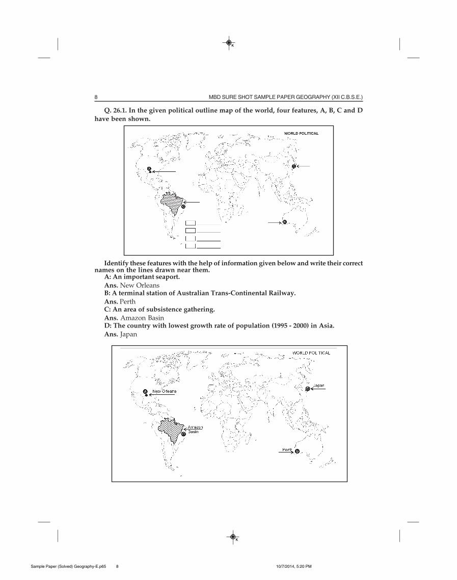
Q. 26.1. In the given political outline map of the world, four features, A, B, C and D
have been shown.
Identify these features with the help of information given below and write their correctnames on the lines drawn near them.
A: An important seaport.
Ans. New OrleansB: A terminal station of Australian Trans-Continental Railway.
Ans. PerthC: An area of subsistence gathering.
Ans. Amazon BasinD: The country with lowest growth rate of population (1995 - 2000) in Asia.
Ans. Japan
Sample Paper (Solved) Geography-E.p65 10/7/2014, 5:20 PM8
9QUESTION PAPERS – 2014 (SOLVED)
K
K
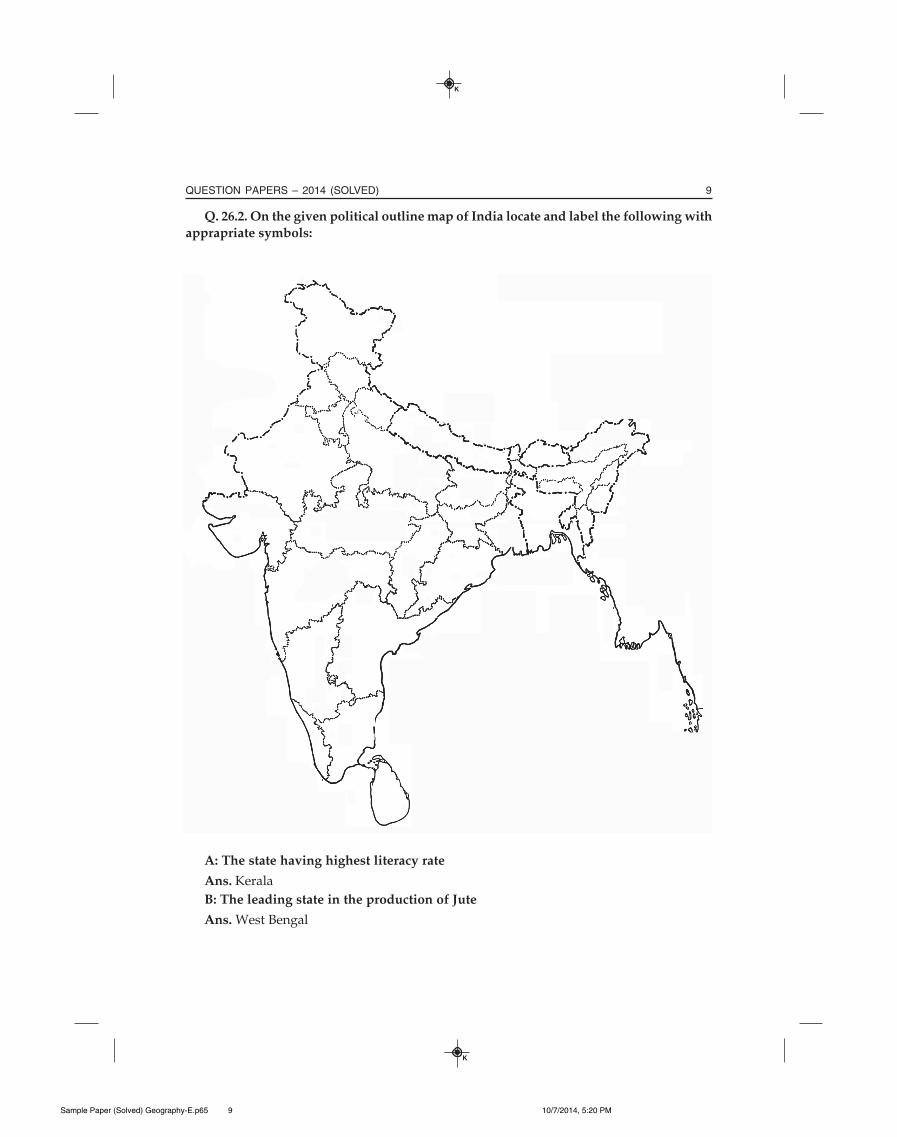
Q. 26.2. On the given political outline map of India locate and label the following with
apprapriate symbols:
A: The state having highest literacy rate
Ans. Kerala
B: The leading state in the production of Jute
Ans. West Bengal
Sample Paper (Solved) Geography-E.p65 10/7/2014, 5:20 PM9
10 MBD SURE SHOT SAMPLE PAPER GEOGRAPHY (XII C.B.S.E.)
K
K
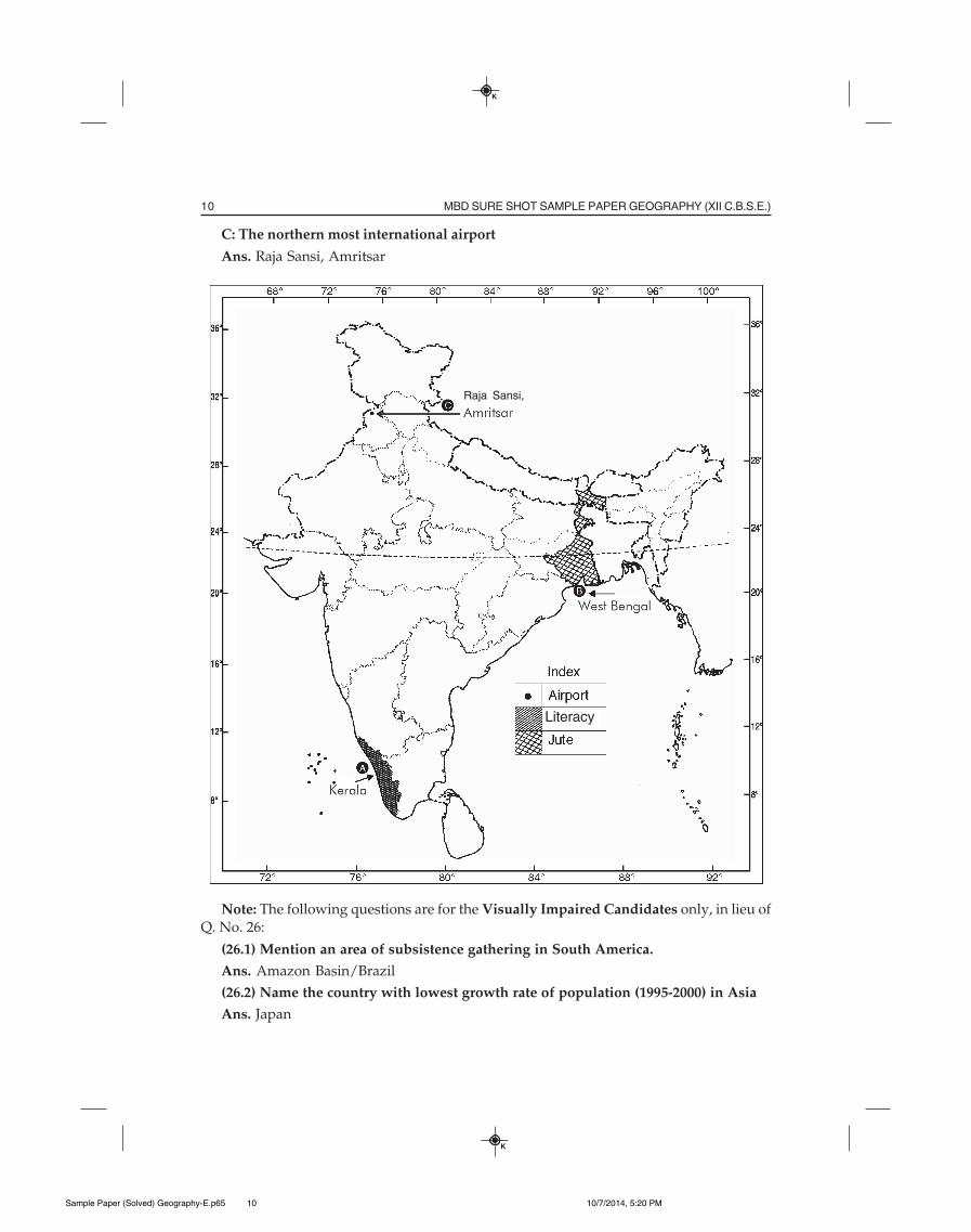
C: The northern most international airport
Ans. Raja Sansi, Amritsar
Note: The following questions are for the Visually Impaired Candidates only, in lieu ofQ. No. 26:
(26.1) Mention an area of subsistence gathering in South America.
Ans. Amazon Basin/Brazil
(26.2) Name the country with lowest growth rate of population (1995-2000) in Asia
Ans. Japan
Literacy
Raja Sansi,
Sample Paper (Solved) Geography-E.p65 10/7/2014, 5:20 PM10
11QUESTION PAPERS – 2014 (SOLVED)
K
K
(26.3) Which state has the highest literacy rate in India.
Ans. Kerala
(26.4) Name the leading state in the production of Jute in India.
Ans. West Bengal
(26.5) Name the northern most international airport of India.
Ans. Raja Sansi, Amritsar
SET – II
Time Allowed: 3 Hours Max. Marks: 70
General Instructions : Same as given for Set-I, D.B- 2014.
Note: The remaining questions are already given in Set-I.
Q. 4. Mention the busiest ocean route of the world. 1
Ans. North Atlantic Ocean route.
Q. 7. Name the port developed as a Satellite port to relieve the pressure at ‘Mumbai’
port. 1
Ans. Jawaharlal Nehru Port.
Q. 12. What are the traditional large-scale industrial regions? Give any two
characteristics of these. 1+2=3
Ans. Large-scale traditional industrial regions are based on heavy industry. These are
usually located near coal-fields and engaged in heavy industries, chemical manufacturing
and metal smelting. These industries are also known as smokestack industries.
Characteristics:
(i) High percentage of people is employed in these manufacturing industries.
(ii) There is high density of housing having poor services.
Q. 15. Explain the main aims of Bharmaur Tribal Area Development Plan. 3×1=3
Ans. (i) Its aim was to improve the quality of life of Gaddis.
(ii) To enhance the level of development of Bharmaur and many other parts of Himachal
Pradesh.
(iii) To develop the transport and communication as well as agriculture and allied industries.
(iv) To establish schools, infrastructure and to provide healthcare facilities, electricity
and good drinking water.
Q. 18. Describe any three problems of slums in India. 3×1=3
Ans. (i) There is a lack of basic amenities like toilet, safe drinking water, electricity, etc.,
in slums.
(ii) People are prone to diseases and illness as they are malnourished.
(iii) Poverty makes people vulnerable to drug abuse, alcoholism, crime and exclusion
from society.
Sample Paper (Solved) Geography-E.p65 10/7/2014, 5:20 PM11
MBD Sample Paper Geography 12 CBSE(English Medium)
Publisher : MBD GroupPublishers ISBN : 9789351852209 Author : Panel Of Experts
Type the URL : http://www.kopykitab.com/product/5592
Get this eBook
40%OFF