Embed Size (px)
Citation preview

Jennifer Bonnell: Presentation to the Canadian Historical Association Annual Meeting
Ottawa, Ontario, May 24-27, 2009
Imagined Futures and Unintended Consequences:Toronto’s Don River Improvement Project, 1880-1910
Introduction
Like a “monster of ingratitude,” ship captain Hugh Richardson wrote in 1834, the
“alluvial disgorgings” of the Don River have displaced “by far the greater part” of the waters of
Toronto Bay. “The whole of the marsh to the East, once deep and clear water, is the work of the
Don, and in [Toronto Bay], where now its destructive mouths are turned, vegetation shews itself
in almost every direction, prognosticating the approaching conversion of this beautiful sheet of
water into another marshy delta of the Don.”1 Reflecting on Richardson’s vitriolic attack on the
river, nineteenth century Toronto historian Henry Scadding was more diplomatic in his
assessment. The Don’s “true value and capabilities,” he wrote in 1873, were not revealed until
the right men appeared, possessed of the intelligence, the vigour and the wealth equal tothe task of bettering nature by art on a considerable scale…. Speedily then were itschannel and outlet put to their proper and foreordained use, being transformed by meansof cribwork and embankments into a convenient interior harbour for Toronto, anarrangement of high importance to the interests of a now populous quarter.12
For Scadding, the Don was not so much a malignant presence as an undervalued resource. His
assessment anticipated the modern, authoritarian, and technocratic approach to the river adopted
by proponents of the Don Improvement Project in the 1880s and 90s. Comparable to what James
C. Scott has called a “high modernist” approach to urban development, this approach viewed
natural environments and their associated human interactions as essentially knowable,
predictable, and malleable entities. As I shall argue in the discussion that follows, the Don
1 Richardson, H., Chisholm, W., and Chewett, J.G., “Report of the Select Committee on the Improvement of the
Harbour of York, 1834,” in Memorandum with Accompanying Plans and Documents Relative to the Past and
Present State of the Harbour of Toronto (Ottawa: Department of Public Works, 1881).2 Henry Scadding, Toronto of Old: Collections and Recollections Illustrative of the Early Settlement and Social Life
of the Capital of Ontario (Toronto: Adam, Stevenson & Co., 1873), 559-60.
2
Improvement fell short in large part due to the failure of its designers to adequately comprehend
the complexity of the systems they sought to transform.3
The “Don Problem”
Toronto’s Don River runs from its headwaters in the moraine lands north of the city 38
kilometres south to its outlet in Lake Ontario, east of the present city centre (figure 1). In the
nineteenth century, the river’s lower reaches formed the eastern boundary of the city (figure 2).
Peripheral by definition, the river valley also came to take on peripheral functions, absorbing
increasing quantities of municipal and industrial wastes as the century progressed. By the 1880s,
the Don was widely recognized as a menace to public health. Heavily polluted waters stagnated
in the slow moving, serpentine reaches of the lower river and the massive reach of marshlands at
its mouth. Fear of miasmas fueled public perceptions of the area as a dangerous space, together
with very real and repeated outbreaks of cholera and typhoid fever.
From the perspective of ship captains and harbour officials, even more significant than
the problem of filth and disease was the costly and pernicious problem of siltation. Annual
accumulations of silt and debris at the mouth of the Don threatened navigation in Toronto
harbour and filled lakeshore water lots with sediment, presenting a persistent challenge to
waterfront industry (figure 3). Intimately connected to the problem of siltation was the problem
of flooding on the Don. Every year, spring freshets and fall rainstorms flushed higher quantities
of water-borne silts and floating debris into the harbour. Viewed from the perspective of the
harbour, the central concern with flood waters was not the water itself but what it carried with it.
From the perspective of riverside farmers and industries, however, flood waters endangered
lives, threatened properties, livestock, and livelihoods.
3 James C. Scott, Seeing Like a State: How Certain Schemes to Improve the Human Condition Have Failed (Yale
University Press, 1999).

3
The “Don problem,” as it became known, prompted a series of largely fruitless
interventions in the 1870s and 80s, culminating in the Don Improvement Plan of 1886. The
project saw the meandering Lower River straightened, widened, and deepened, dramatically
transforming the landscape and hydrology of the marshy lower valley. What was initially
conceived as a two-year, $300,000 project, however, proved far more complicated and time-
consuming to implement than planners originally thought. Even more damning was the fact that
it largely failed to fulfill expectations. Complications arose as a result of the planners’ failure to
comprehend in a detailed way the environment they were working with, to allow for an element
of unpredictability in local ecological systems, and to anticipate the potential obstacles that can
emerge in stakeholder negotiations over property rights. In other words, engineers’ attempts to
transform a complex riparian system into a “flush” for wastes and debris and a viable corridor for
shipping and rail traffic were too willing to assume a blank slate—a river patiently awaiting the
revelation of its “true value and capabilities.” For all the success of projects elsewhere to
transform urban environments into working components of the industrial landscape, the Don and
its seasonal processes proved extremely difficult to contain.
Important to recognize in all of this is that the Don is a small urban river, bearing little
resemblance to great rivers such as the Thames or the St. Lawrence that have been harnessed by
other cities for urban infrastructure projects (figure 4). Why, then, was Toronto so desperate to
make it into something it wasn’t? At the time the Don Improvement was being implemented,
other North American cities were taking advantage of steam power and railways to create new
industrial hubs outside of city centres, and moving away from their former dependence on rivers
as drivers of industry. Toronto, conversely, chose to invest massive amounts of public funds into
the development of a minor river relatively close to the city centre. In the discussion that

4
follows, I will identify some of the forces at work that propelled the city to take on the project,
and assess the degree to which they succeeded in meeting their goals.
Imagined Futures: the Don “as it ought to be”
For residents of Toronto’s east end, the idea of the improvement conjured images of prosperity
and revitalization for an area that had long been relegated to the margins of the city. Throughout
the early 1880s, they regularly petitioned Council to take action in implementing a river
improvement scheme. Their dreams for the area were ambitious. At a public meeting to discuss
the project in October 1881, for example, land owner J.P. Doel “pleaded on behalf of the health
of the neighbourhood and city for the straightening and deepening of the Don,” imagining a
future where the Don would become “the great shipping centre for Toronto.”4 Alderman Thomas
Davies, who represented the Donlands area at City Council, perhaps best expressed the vision of
area residents in his submission to the City’s Committee on Works in early January 1882:
This great scheme… will afford sites and facilities for all kinds of manufacturingenterprises, coal yards, lumber yards, and many factories we may not now think of, theestablishment of which will most assuredly go far towards making Toronto, what Ibelieve it is destined to become, a great manufacturing as well as a business centre….The miasmatic atmosphere with which this locality is too often troubled will be dispelledand the healthfulness greatly increased. Freshets and ice-jams will be things of the past,and the current in the River unobstructed….5
The project, he concluded, will “make [the area] as it ought to be—as healthy as any other part of
the City.”6 The improvements, in sum, would turn a stigmatized and peripheral area into a
productive district of the city, producing profits for the City and local landowners alike.
Underlying these visions of a rationalized Don River was the still recent memory of the
devastating flood of September 1878 (figure 5). Remembered as the “Great Rainstorm,” the
4 The Globe, “The Don River,” 10 October 1881, p.7.5 Report No.56 of the Committee on Works. Appendix 888-890, City of Toronto Council Minutes (hereafter
CTCM), 1881.6 Minute 1026, 3 October; Minute 1043, 10 October; Minute 1246, 19 December, CTCM 1881.

5
storm dropped five inches of rain on the city over four days, causing the river to rise a record
eight feet above normal levels. By no means the first large flood on the Don—studies of
nineteenth century flood patterns in the watershed reveal at least thirteen major floods over the
course of the century7—it was certainly the most devastating in its effects. Four of the six
bridges spanning the Lower Don were destroyed when wreckage from upstream bridges and
buildings upstream crashed into the bridges below them, creating a domino effect of destruction.
On the east branch of the river alone, thirty mill dams and twenty bridges fell to the churning
waters. At least two people were killed along the Don: a nine-year old girl swept from the river
bank near Don Mount, and a man who had attempted to cross the Queen Street bridge shortly
before it collapsed. By the time the waters receded and communication had been reestablished
with isolated communities, local newspapers estimated damages in the watershed within the
range of $200,000 to $400,000.8 Seared into the consciousness of riverside residents and
industrialists, the Great Rainstorm of 1878 played an important role in cementing public support
for the Don Improvement Plan of the following decade.
While area landowners and industrialists sought to remove the uncertainty and
insalubriousness of their surroundings, City Council members saw the improvements as an
opportunity to augment paltry assessment revenues, and to address flooding and pollution
concerns that increasingly carried the threat of litigation. Present in mind for early project
proponents was the success of other urban centres in transforming listless urban waterways into
bustling hubs for industry. In his 1881 inaugural address to Council, Toronto Mayor W.B.
McMurrich made special mention of the promise held by the river:
7 Ontario Department of Planning and Development, Don Valley Conservation Report (Toronto: Ontario
Department of Planning and Development, 1950), Part IV, 6-8.8 Globe, “The Great Rainstorm,” 14 September 1878, p.8; “The Great Rain Storm,” 16 September 1878, p.1.

6
The eastern end of the City along the banks of the Don and the marsh seems to have beenspecially fitted by nature as the site for manufactures of all descriptions, and judgingfrom the experience of other cities, it will not be long before the advantages of theposition will be fully realized.9
Travelling to Cleveland in the fall of 1881 for President Garfield’s funeral, McMurrich was
apparently “struck at the way in which manufactures had clustered round a little stream [the
Cuyahoga River] which had been likewise improved,” leaving him with “no doubt that in East
Toronto they would find the same result with reference to the Don.”10 Here was comparable
context: a relatively small urban waterway subject, like the Don, to chronic problems of
flooding, siltation, and pollution, transformed with dredges and pile-drivers into a vital industrial
corridor in its lower reaches. McMurrich returned to Toronto with new resolve to push forward
an improvement scheme for the Don.
While Council prepared specification plans and sought provincial legislation to carry out
the improvements, another factor emerged that further propelled the City’s resolve. The
Canadian Pacific Railway Company, which had attempted since 1881 to connect their east-west
lines with Toronto, succeeded in the spring of 1886 to win the support of City Council to create
an eastern entrance to the City along the west bank of the Don Improvement.11 The significance
of this timing should not be overlooked: the improvement would be completed within the context
of larger municipal efforts to accommodate railway development in the city. A straightened
river would facilitate the laying of tracks into the city; filled land in the former meandering river
channel would create additional space for rail-side industry. (And for several aldermen with
manufacturing firms along the river, the relocation of the river channel would extend their
property and increase its value through proximity to the railway). In the process, the realigned
9 Appendix, 1, 5 January, CTCM 1881.10 Ibid.11 Frances N. Mellen, “The Development of the Toronto Waterfront During the Railway Expansion Era, 1850-1912”
(Ph.D. Dissertation, University of Toronto, Department of Geography, 1974), 167, 178.

7
Don would become a transportation corridor not only for shipping traffic, but for rail and
associated roadways—in John Stilgoe’s words, a “metropolitan corridor” with all its associations
of modernity and prosperity.12 Adding the interests of a powerful railway company did much to
secure project fortunes, and in March 1886 the Don Improvement Act was passed by the
provincial legislature, empowering the City to borrow funds and expropriate lands to complete
the improvement works. A public referendum in September 1886 gave Council the final go-
ahead, and construction work began the following month.13
The Don Improvement, 1886-1890
Concentrating on a portion of the Lower River between Winchester Street and the Grand
Trunk Railway bridge at Eastern Avenue, the Don Improvement works would see the river
channel straightened, deepened to twelve feet below lake-level, and widened to 120 feet (figure
6). A one-hundred foot corridor alongside the Improvement would be reserved for rail and
roadway purposes, and existing bridges would be replaced with more enduring structures.14 The
works were designed to meet four central objectives: 1) to improve the sanitary condition of the
area, 2) to make the Don a navigable stream for large vessels; 3) to accommodate rail traffic into
the City; and 4) to create new lands for industrial purposes.15 Flood control was considered an
associated benefit. By the end of 1887, the bulk of the piling for the new river channel had been
completed, and the channel from the GTR bridge to King Street nearly finished.16
Disputes with contractors, costly and time-consuming settlements with expropriated
property owners, and protracted negotiations with railway interests, however, all contributed to
12 John R. Stilgoe, Metropolitan Corridor: Railroads and the American Scene (New Haven and London: YaleUniversity Press, 1983).13 Appendix, 809-810, CTCM 1886.14 Annual Report for the City Engineer for 1887, Appendix, 1896-8, CTCM 1888.15 Mayor’s Inaugural Address, Appendix, 14-15, CTCM 1889.16 Appendix, 4-5, CTCM 1888.

8
delay project progress and increase expenditures. Not least among these problems was the
environment itself. As dredging equipment pushed north beyond King Street, dense clays
encountered along the route of the new channel made for slow and difficult work. The extra time
and expense required to remove clay substrates eventually forced Council to reduce the depth of
the channel between Gerrard and Winchester Street to eight feet (rather than the twelve feet
originally proposed).17 These modifications had significant repercussions for project objectives:
lost in that difference of three to four feet of channel depth was the vision of a navigable channel
north of Gerrard Street; flood protection and “pollution flushing” objectives may also have been
compromised in creating a wide and ultimately shallow channel, rather than one with the ability
to accommodate higher flows. Work on the new channel was finally completed in 1891, at cost
of almost $580,000—almost double original estimates (figures 7, 8 and 9).18
Failures and Unintended Consequences
Shortages of funds and political will, however, had produced a project that was
necessarily fragmentary: only one section of the river had been modified, rather than the full
distance from Bloor Street to the lake contained within the initial 1886 proposals. For the
Toronto Harbour Commissioners, the Improvement was a farce: in ignoring the river’s mouth, it
failed to address their central concern with siltation in Toronto harbour. Dredging expenditures
continued to drain their budgets throughout the twentieth century (figure 10). Compromises in
the channel depth, coupled with the failure to erect a swing bridge at the GTR crossing, dashed
area residents’ hopes for a Lower Don lined with docks and coal yards and bustling with ship
traffic.
17 Report of the City Engineer, 15 August 1888, Appendix, 1505-6, CTCM 1888; Mayor’s Inaugural Address,
Appendix, 14-15, CTCM 1889.18 The Mail & Empire, 12 February 1902, reprinted in Vaughan Roberts Papers, p.22.

9
The project had failed in other ways as well. Pollution continued unabated. As early as
1894 it was apparent that faith in the project’s ability to “flush” contaminants and detritus
through a deepened and straightened lower channel had been misguided. A columnist for The
Toronto Mail, for example, described the “widened Don River” as a “pestilential channel… of a
yellowish green colour, and a slimy, soup-like consistency.”19 Sewage from east end
neighbourhoods continued to discharge untreated into the river; its “slow currents,” reputedly,
did little to dilute and disperse contaminants. Not surprisingly, public health continued to suffer.
Two to three hundred cases of typhoid fever per year remained the norm in the early 1890s; a
severe outbreak in 1891 provided a potent reminder of the filthy state of Toronto harbour and its
tributary streams.20
Chronic problems with flooding, ice jams, and siltation also persisted, making mockery
of Alderman Davies’ 1882 vision that “freshets and ice-jams will be things of the past, and the
current in the River unobstructed.” An ice jam that formed near the river mouth in late February
1902 caused considerable flooding along the Lower River, submerging cellars, washing out
roads and temporarily blocking the railway lines (figure 11).21 The spring freshet of April 1912
was more serious, destroying six mill dams along the river and prompting the Mail & Empire to
describe the condition of the Don as “a rampage which baffles the memory of the ‘oldest
inhabitant’ in the Valley.”22 Memories of the devastating damage caused by the 1878 flood must
have run short (figure 12). Evident in these failures, beyond the apparent neglect of the
complexity and unpredictability of natural systems, is the failure to account for present and
19 The Toronto Mail, 20 March 1894, reprinted in Vaughan Roberts Papers, SC 26, box 4, vol. 4, 18-19, TorontoPort Authority Archives.20 Catherine Brace, “One Hundred and Twenty Years of Sewerage: the Provision of Sewers in Toronto 1793-1913”
(M.A. Thesis, University of Toronto, Department of Geography, 1993), 132.21 The Mail & Empire, 1 March 1902. Cited in the Don Valley Conservation Report, Part IV, 15.22 The Mail & Empire, 6 April 1912. Cited in Ibid.

10
future human influences on the river system—the amount of sewage already entering the river,
for example, and the effects of upstream deforestation on river hydrology. Engineers were
“improving” not just a river, but a complex amalgam of human and natural forces.
For contemporaries of the project and for today’s Toronto residents looking back on the
legacy of the Don Improvement, it is difficult, indeed, to pinpoint any concrete benefits that
accrued for the residents of the city, and for those that continued to live near its banks.
Certainly, stronger bridges at the major crossing points along the Lower Don allowed for more
reliable travel between communities east and west of the river, and the construction of a
passenger rail station at King Street allowed greater mobility for east end residents. The
industrialization that did occur along the river south of Gerrard Street brought jobs for the area’s
growing working class population (figures 13 and 14). But the major problems it set out to
address—flooding, poor sanitary conditions, and the lack of navigability of the Lower
River—persisted for years after the dredges had retired and the money had been spent. Losses to
the human experience of the Lower Don would also have been apparent to area residents. As
local historian George Rust D’Eye comments, the improvement “included the removal of five
small islands between Queen and Winchester Streets, and the straightening of three big meanders
and two small ones…. [while] fill taken from the hillsides surrounding the Don Valley
permanently altered the appearance of the landscape.”23
Damages to the ecological integrity of the river system are more difficult to assess,
imbricated as they were with other factors such as the disposal of raw sewage into the river
further upstream and the subdivision and clearing of remaining forested lands further north in the
watershed. Certainly, the project set in motion the accelerated urbanization of the watershed: in
23 George H. Rust-D'Eye, Cabbagetown Remembered (Erin, Ontario: The Boston Mills Press, 1984), 91.

11
the first half of the twentieth century, development in the area saw the filling of more wetlands
and the pouring of more concrete over previously porous soils, exacerbating flood conditions in
the watershed still further.
Etched into the landscape and its ongoing ecological processes, the Don Improvement
presents a legacy of late nineteenth century approaches towards urban environments. Perhaps
most obviously, it demonstrates the challenges faced by late nineteenth century engineers in
rationalizing a dynamic river system already linked in complex ways with the city’s metabolism.
As some observers of the river recognized as early as the 1830s, a trunk sewer would likely have
gone a greater distance in solving the “Don problem” than all the effort and expenditure made to
straighten and deepen a recalcitrant urban waterway. Today, the Don is Canada’s most
urbanized river, and among its most polluted. The river’s condition and the industrial
brownfields that line its lower banks have prompted a new Don Improvement scheme, this time
directed at the mouth of the river and its entrance to the harbour. Like the 1880s improvement,
economic revitalization and pollution abatement are among the project’s key objectives (figure
15). Whether the project will profit from the mistakes of past efforts to remake the river remains
to be seen.

12
Figure 1, The Don River Watershed
Courtesy of the Toronto and Region Conservation Authority

13
Figure 2, City of Toronto, 1866
W.C. Chewett & Co., 1866, National Map Collection 25145, Courtesy of the University ofToronto Map Library.

14
Figure 3, Silt from the Don River entering the harbour through the eastern gap, September 1962.
Toronto Port Authority Archives, PC 14/6845

15
Figure 4, The Don River Valley, c. 1900
Archives of Ontario C 127-2-0-5-6

16
Figure 5, Don River in Flood, c.1907
City of Toronto Archives, Fonds 1244, Item 2477

17
Figure 6, River Don Straightening Plan, 1886
City of Toronto Archives, Series 725, File 12.
18
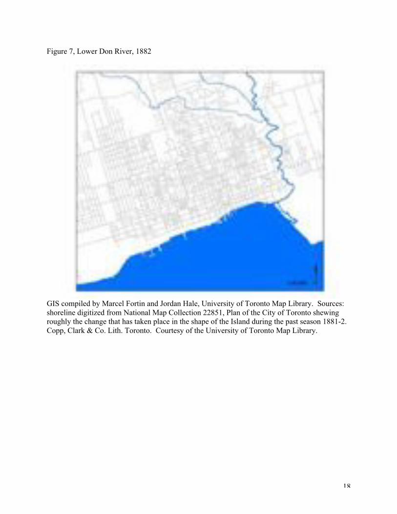
Figure 7, Lower Don River, 1882
GIS compiled by Marcel Fortin and Jordan Hale, University of Toronto Map Library. Sources:shoreline digitized from National Map Collection 22851, Plan of the City of Toronto shewingroughly the change that has taken place in the shape of the Island during the past season 1881-2.Copp, Clark & Co. Lith. Toronto. Courtesy of the University of Toronto Map Library.

19
Figure 8, Lower Don River, 1894
GIS compiled by Marcel Fortin and Jordan Hale, University of Toronto Map Library. Sources:shoreline digitized from National Map Collection 97370, Plan of the City of Toronto, 1894,Toronto: City Engineer’s Office, Copp, Clark Co. Ltd., Courtesy of the University of TorontoMap Library.

20
Figure 9, Detail from “City of Toronto, 1893” (note industry along Lower Don, including the oilrefinery east of the bend, and the Gooderham & Worts cattle sheds on the north-west bank nearthe river mouth.
Toronto Public Library, TRL, Historical Picture Collection, 916-2-1.

21
Figure 10, Dredging debris from the river mouth, April 1951
Courtesy of the Toronto Port Authority Archives.

22
Figure 11, Clearing ice from railroad tracks, Don Valley, c.1910
City of Toronto Archives, Fonds 1244, Item 5028

23
Figure 12, Flood on Lower Don, March 1920
City of Toronto Archives, Fonds 1231, Item 1189.

24
Figure 13, Industry along the Lower Don, 1858
GIS compiled by Marcel Fortin and Jordan Hale, University of Toronto Map Library. Sources:Industrial establishments from W.S. and H.C. Boulton, Atlas of Toronto, 1858, courtesy of theToronto Public Library. Shoreline digitized from City of Toronto, 1857, Waterlow & Sons, G3524 T61 1857. Courtesy of the University of Toronto Map Library.

25
Figure 14, Industry along the Lower Don, 1892
GIS compiled by Marcel Fortin and Jordan Hale, University of Toronto Map Library. Sources:Industrial establishments drawn from Charles E. Goad, Atlas of the City of Toronto, 1892.Shoreline digitized from Map of Toronto and Vicinity, Bureau of Mines, Ontario Department ofLands Forests & Mines, 1891, G 3501 C5 1891 22G, Courtesy of the University of Toronto MapLibrary.

26
Figure 15, Proposed Don Mouth Naturalization Project, 2008
Courtesy of Waterfront Toronto.

27
References
Primary Sources
City of Toronto Archives. Fonds 200. Former City of Toronto Fonds.
Vaughan Roberts Papers, Toronto Port Authority Archives.
Secondary Sources
Brace, Catherine. “One Hundred and Twenty Years of Sewerage: the Provision of Sewers
in Toronto 1793-1913.” M.A. Thesis, University of Toronto, Department of
Geography, 1993.
Mellen, Frances N. “The Development of the Toronto Waterfront During the Railway
Expansion Era, 1850-1912.” Ph.D. Dissertation, University of Toronto,
Department of Geography, 1974.
Ontario Department of Planning and Development. Don Valley Conservation Report.
Toronto: Ontario Department of Planning and Development, 1950.
Richardson, H., Chisholm, W., and Chewett, J.G. “Report of the Select Committee on the
Improvement of the Harbour of York, 1834.” In Memorandum with
Accompanying Plans and Documents Relative to the Past and Present State of the
Harbour of Toronto. Ottawa: Department of Public Works, 1881.
Rust-D'Eye, George H. Cabbagetown Remembered. Erin, Ontario: The Boston Mills
Press, 1984.
Scadding, Henry. Toronto of Old: Collections and Recollections Illustrative of the Early
Settlement and Social Life of the Capital of Ontario. Toronto: Adam, Stevenson &
Co., 1873.

28
Scott, James C. Seeing Like a State: How Certain Schemes to Improve the Human
Condition Have Failed. Yale University Press, 1999.
Stilgoe, John R. Metropolitan Corridor: Railroads and the American Scene. New Haven
and London: Yale University Press, 1983.