Embed Size (px)
Citation preview

line
An HO scale track plan for Southern Pacific’s Shasta Route makes the most of a 22 x 45-foot room
the mountainsthroughMain
Otis McGee and several friends arebuilding an HO scale SouthernPacific Shasta Route layout basedon a John Armstrong track plan.Here we see SP Cab-Forward no.4285 leading a North Coast Perish-able train over a Harriman-erathrough-truss bridge at Sims. Modelphotos by Jim Providenza and Bill Kaufman
© 2010 Kalmbach Publishing Co. This material may not be reproduced in any form without permission from the publisher. www.ModelRailroader.com

04/05 • Model Railroader 61
By John Armstrong
The key to developing a track planthat can become a model railroadwith realistic appearance and oper-
ations is making and implementing aseries of good choices. When I’m devel-oping a plan for a client, it’s importantthat the person has a clear concept ofwhat they want their model railroad tobe. Is the client more interested inscenery or operations? Do they want ageneric or prototypically accurate rep-resentation of a real railroad? These arejust some of the questions I posed toOtis McGee, Jr., when I developed thisHO scale track for him.
Asking questions also helps clientssee the benefits and drawbacks to eachlayout approach. On a generic South-
ern Pacific layout, the trackage wouldrepresent a line somewhere in the west-ern United States. The station designsand signaling would follow SP prac-tices, but the towns and yards modeledwould be fictitious.
However, when Otis approached meto design this layout, he wanted to takea more ambitious approach by model-ing a portion of SP’s Shasta Route. Theprototype offered abundant scenic andoperational features that, with appro-priate compression, could be convertedinto model form. With ample space towork in, it’s easy to understand why ageneric layout just wouldn’t do.
In this article I’ll walk you throughthe thought process that went intodesigning this track plan. You’ll seethat by asking the right questions andcarefully working through the layout-design process, track planning can befun and enjoyable.
Meeting criteriaThe layout Otis is building is located
in a large room, reached from a four-car garage below by a U-shaped stair-case. The staircase is wide enough that4 x 8-foot sheets of plywood can bebrought into the layout room even afterthe doorway is spanned by benchwork.
The track plan had to meet severalcriteria: a minimum track radius of 40"to accommodate 2-10-2, 4-10-2, andCab-Forward steam locomotives; noscenes on the main line can be passedthrough more than once; a minimum
aisleway clearance of 30" is required;and the layout should be a mushroommultilevel design without duckunders.
Within these constraints, an around-the-walls model railroad feeding intolines on both sides of a single serpen-tine peninsula extending to a helixseemed to be the best option becauseit was possible to include almost fivescale miles of main line while stillmaintaining 30" or better aislewaysalong most of the route. With a layoutstyle selected, it was now time to turnmy attention to the scenic elements ofEspee’s Shasta Route.
Along the lineCapturing the essence of the Shasta
Route in the steam-to-diesel transitionera was a matter of condensing as manyof its most defining segments as possi-ble, in order, on a visible main line.
A keystone of the Shasta Route wasDunsmuir, Calif. Located at the foot of ahelper grade, trains from both theSiskiyou and Cascade Lines ran throughthis railroad town. Dunsmuir was hometo a large engine terminal and modest-sized yard that are compressed in thetrack plan. The roundhouse has 16 stallsinstead of 24 as on the prototype, andthe upper yard has six tracks betweenSacramento Street and the backshopsinstead of nine. An opening in the lower-level backdrop helps to bring criticalparts of the trackwork within arm’sreach for operators and provides a betterview of the roundhouse.
Steep grades and mountainous terrain made for rugged railroading on the ShastaRoute. John Armstrong designed an HO scale track plan of the Shasta Route thatfeatures grades similar to those on the prototype. The line’s namesake mountain,Mount Shasta, can be seen in the background of this photo. Southern Pacific photo

Southern Pacific LinesShasta Division
Castella
BlackButte
Azalea
WEED
Down
Sand
REDDINGLOOP
McColl
Tunnel 1
Tunnel 2
PitBridge
Sims
Dunsmuirlower yard
DUNSMUIR
Lower level
Small
Cantara
GenericTimber Inc.
Caboosetracks
Oil tank
Helixup
Lowbackdrop
Sacramento St.
SacramentoRiver
C
C
AA
B B
Room size 22' x 45'Scale: 3⁄16" = 1'-0"24" gridHO scaleArrows indicate photo locations
58"
60"
33"
49"
49"
47"
48"
50"
74" 74"
74"
72" 47"
72"
70" 68"
68"
70"
70"
66"
72"
64"
62"60"
56"
54"
52"
52" helix46" loop
8"
8"
8"
16"
16"
16" 51"
50"
To upperlevel
Raised floor
Lead
Sidebar
The lower yard at Dunsmuir also hadto be compressed from the prototype’s17 tracks to four. The yard sits on a 1percent grade. For the sidings to provide20- to 25-car capacity the tracks had tobend around a horseshoe, but the cou-pling and uncoupling areas are reason-ably straight. Many of today’s modelshave very free-rolling trucks, though, soeven the modest 1 percent grade mayprove to be a nuisance. As a precaution,I designed the benchwork so the gradecould be eliminated if desired.
Climbing the gradeComing out of Dunsmuir, trains
begin climbing the 2.75 percent gradeup to Black Butte. This part of the linepasses through Small on its way to thescenic Cantara Loop, where the tracksparallel the river. The radius from Can-tara to Azalea was reduced to 38". Evenwith the reduced radius, this stretch ofthe layout still consumes about 120square feet. This includes the horseshoeitself, as well as the second curveneeded to return to normal shelf width.
Between Cantara and Azalea there’san optional logging operation. The log-ging scene utilizes some empty spacebut highlights another problem withhorseshoe curves – access.
Fortunately, the track is approach-ing eye level by this point, and the ter-rain is such that a good-sized accessopening reached by a comfortable (morethan 60" clearance) duckunder can beleft without a top. The foreground canbe contoured so the hole is out of sight.
Approaching Azalea, two steps upbring operators back to eye level withthe layout for the rest of the climb toBlack Butte and its wye junction withthe Siskiyou Line. But how should thisline be represented?
The layout is high enough abovefloor level to accommodate an un-scenicked, along-the-walls return loopwith lavish staging sidings in the crewlounge, workshop, and dispatcher’soffice without interfering with thefunctionality of this portion of the lay-out. However, we’ll leave that loop as afuture possibility. Instead, a modestwye-tail alignment proves a workablealternative, as shown in the track plansto the right.
Facing the big peakKey scenic features (primarily the
line’s namesake, Mount Shasta) and the north-south alignment of the ShastaRoute lead to a serious complication. It’snormally possible to create a going-somewhere, directionally consistent feel-ing while still following the layout’sconvolutions where viewing angles are
62 Model Railroader • modelrailroader.com
Illustrations by Jay Smith
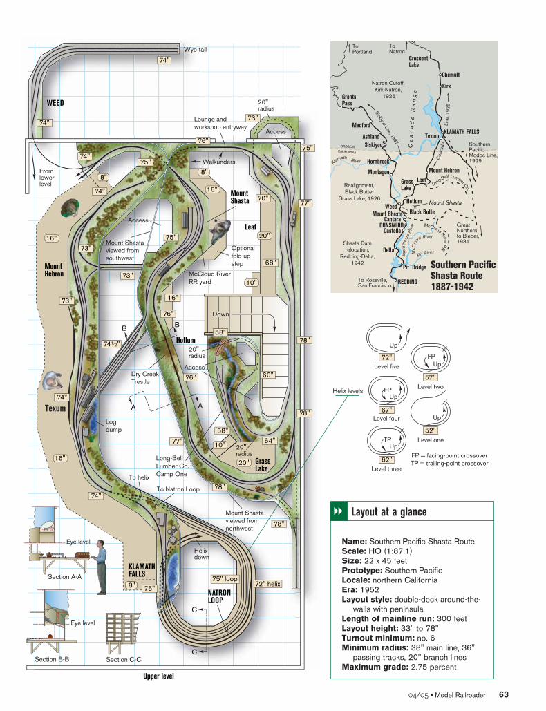
WEED
Hotlum
Leaf
Down
Texum
MountHebron
MountShasta
Wye tail
McCloud RiverRR yard
GrassLake
Logdump
KLAMATHFALLS
NATRONLOOP
Section A-A
Section C-CSection B-B
AA
B B
Long-BellLumber Co.Camp One
78"
78"
78"
64"77"
68"
77"70"
74"
75"75" loop
73"
73"
76"75"
75"
76"
76"
78"
60"
58"
58"
16"
74"
73"
73"
741⁄2"
74"
74"
74"
74"
75"
72" helix
C
C
Mount Shastaviewed fromnorthwest
Mount Shastaviewed from southwest
Dry CreekTrestle
Lounge and workshop entryway
WalkundersFromlowerlevel
Access
Access
20" radius
20" radius
20" radius
Access
Optionalfold-upstep
To helix
Helixdown
Eye level
Eye level
To Natron Loop
8"8"
8"
16"
16"
16"
20"
10"
10"
20"
Upper level
04/05 • Model Railroader 63
OREGON
Southern PacificShasta Route1887-1942
ToPortland
ToNatron
Natron Cutoff, Kirk-Natron,
1926
CALIFORNIA
Siskiyou Line, 1887SouthernPacificModoc Line,1929
GreatNorthernto Bieber,1931Shasta Dam
relocation,Redding-Delta,
1942
To Roseville,San Francisco
Realignment,Black Butte-
Grass Lake, 1926
Cas
cade
Lin
e, 1
926
Ca
sc
ad
e R
an
ge
Long-Bell Lumber Co.
Kl
amath River
McC
lo
ud River
Sac
ram
ento
Riv
er
Pit River
McCloud River RR
REDDING
Pit Bridge
Delta
CastellaDUNSMUIR
Cantara
WeedHotlum Mount Shasta
LeafMontague
Hornbrook
SiskiyouAshland
Medford
Kirk
Texum
Chemult
Mount Shasta Black Butte
GrassLake
Mount Hebron
GrantsPass
KLAMATH FALLS
CrescentLake
52"
57"
62"
67"
72"Level five
FP
Level four
TP
Level three
FP
Level two
Up
Level one
FP = facing-point crossoverTP = trailing-point crossover
Helix levels
Up
Up
Up
Up
� Layout at a glance
Name: Southern Pacific Shasta RouteScale: HO (1:87.1)Size: 22 x 45 feetPrototype: Southern PacificLocale: northern CaliforniaEra: 1952Layout style: double-deck around-the-
walls with peninsulaLength of mainline run: 300 feetLayout height: 33" to 78"Turnout minimum: no. 6Minimum radius: 38" main line, 36"
passing tracks, 20" branch linesMaximum grade: 2.75 percent

arranged so that west is to the left andeast is to the right, for example.
On the Shasta Route track plan, how-ever, the scenic canyon line from thesouth (timetable west) through Duns-muir must be viewed from the east,meaning north is to the right. For manymiles north of Cantara, the essential fea-ture is Mount Shasta itself, and it canbe seen only in proper relationship tothe track from the west, which meansnorth must now be on the left. The onlysolution is for the line to cross the aisle.
Fortunately, the track is headed forthe Upper Klamath Valley. The layoutbeyond Black Butte is high enough that,with the aisle taking two steps backdown to floor level, the tracks can crossthe aisle and operators can comfortablywalk under the scene.
McCloud River RR connectionAfter passing under the crossing,
operators enter Mount Shasta, whereanother section of raised floor bringsthem back to eye level with the trains.Mount Shasta is where the SP connectswith the McCloud River RR. The town’snamesake mountain looms properly tothe northeast over the short line’s yard.
But wait. Mount Shasta is actuallySouth of Black Butte! What gives? Well,placing the mountain in its correct loca-tion would have caused complicationssuch that quietly accepting this compro-mise with reality seemed the best choice.
Restoring geographic orderGeographic order is restored when
trains enter Hotlum and pass over theDry Creek trestle. The bridge is some 700scale feet shorter than its prototype but
could be modeled almost as high. Thelow backdrop in this scene allows accessfrom both sides, and viewing along thewider sections of the benchwork pre-cludes raising the floor level in this area.
Trains then proceed to the highestpoint on the line: Grass Lake. Viewedand operated again from eye level,Grass Lake is the end of some helperturns from both directions. The townhas a long passing track, a full-radiuswye, and Mount Shasta in the back-ground, just as it should be.
Is having two separate versions ofMount Shasta on the backdrop dishon-est? Maybe, but not too obvious adeception since the intervening terrainis such that you never see more thanone Mount Shasta at a time.
At this point trains disappear ontoan unscenicked shelf far above the stair-case opening, emerging into the townof Leaf, where logs are picked up fromLong-Bell’s mill. The Long-Bell linedoes a 180 through the lounge area toenter Leaf realistically from the east.Because of its elevation, this portion ofthe layout may need to be reached byladder. The track arrangement is simpleenough that operation should be trou-ble free. No space was devoted to turn-ing locomotives on this nearly scale-mile-long branch since the geared anddouble-ended rod locomotives used onthis line didn’t need to be turned.
Crossing the lineContinuing down on a bit more-
moderate grade (1.6 percent) typical ofthis plateau region of California, thetrack must unprototypically, but invisi-bly, cross itself at grade on its way
toward Mount Hebron. The 90-degreecrossing can be reached from thewalkunder below.
With an elevated aisle again to theeast of the line, the 13- and 19-car lappedsidings at Mount Hebron and Texumallow the longest consists to pass withoutneeding to saw by. The lumber mill atTexum completes a loads-in, empties-outconnection with the McCloud River RRyard at Mount Shasta. In this case there’sa third track so the railroad can make arunaround move to put the caboose onthe right end of the train when both theempty and load tracks are occupied. As alarge mill with its own switcher, Texumproduces mostly finished lumber goingout in boxcars, which look the sameloaded or empty.
The end of the visible line is locatedin the industrial outskirts of KlamathFalls. In a manner similar to that at the other end of the layout below, theturnouts connecting the end loop withits staging sidings and the helix are hid-den in a short tunnel.
Helix detailsThe key to the overall space efficiency
of this layout is the helix, which has 40"-radius curves and 4" of separationbetween levels. The helix is reached via aduckunder and is secluded with a hard-board shroud. Experience has shown,however, that even with reliable loco-motives and electrical control systems,visual confirmation of train movementis desirable. I recommend cutting open-ings in the shroud at each level.
The helix has facing- and trailing-point crossovers so that each of the fourlevels can also function as bidirectional
64 Model Railroader • modelrailroader.com
45"
50"
55"
60"65"
70"
75"
80"
Helix
Feet0 10 20 30 40 50 60 70 80 90 100 110 120 130 140 150 160 170 180 190 200 210 220
Loads
Southern Pacific Lines-Shasta Division
Rai
lhea
d el
evat
ion
abov
e flo
or
HO scale miles = 60 miles0.0 0.5 1.0 1.5 2.0 2.5 3.0 3.5
West (by timetable) East
1percent
2.75 percent
1.0 percent
1.6 percent
Empties
2.75 percent 2.0 percent avg.
1.6 percent
McC
oll
Cast
ella
DUNS
MUI
R
Smal
l
WEE
DDi
amon
d
REDD
ING
LOOP
Tunn
el 1
Tunn
el 2
Sim
s
Duns
mui
r low
er y
ard
Cant
ara
Gene
ric T
imbe
r Inc
.
Azal
ea
Stag
e I
Mou
nt S
hast
aW
ye ta
ilM
cClo
ud R
iver R
R ya
rd
Hotlu
mM
cClo
ud R
iver
RR lo
gs
Stag
e II
Gras
s la
ke
Stag
e III
Leaf
Diam
ond
Stag
e IV
Mou
nt H
ebro
n
Log
dum
pTe
xum
KLAM
ATH
FALL
SLo
ng-B
ell L
umbe
r Co.
Cam
p On
eNA
TRON
LOO
P
Pit B
ridge
Blac
k Bu
tte
McC
oll
Pit B
ridge
Cast
ella
DUNS
MUI
R
Smal
l
WEE
DDi
amon
d
REDD
ING
LOOP
Tunn
el 1
Tunn
el 2
Sim
s
Duns
mui
r low
er y
ard
Cant
ara
Gene
ric T
imbe
r Inc
.
Azal
ea
Blac
k Bu
tte
Stag
e I
Mou
nt S
hast
aW
ye ta
ilM
cClo
ud R
iver R
R ya
rd
Hotlu
mM
cClo
ud R
iver
RR lo
gs
Stag
e II
Gras
s la
ke

staging tracks capable of holding 35cars. As is the case with all other stagingtracks in this plan, track center spacingis 3". The extra inch provides fingerroom for moving cars by hand.
Concealed stagingThe west end of the layout (milepost
0) is at the center of a 40"-radius loopsurrounding tracks of slightly sharper-radius curves for staging an additional70 cars worth of trains.
To get some extra visible main line,trains exiting staging pop into the opena few feet short of the loop turnout,which is hidden in a short tunnel. A connection from the helix that pro-vides continuous-running capabilitysneaks in via Tunnel 2, crosses a highly condensed version of the double-deck Pit Bridge, and then enters the Sacra-mento River Canyon.
Decision timeWith the track plan complete, it’s
now time to select an era for the layout.One factor in this decision is the chal-lenge of re-creating a reasonably authen-tic locomotive fleet for a specific period.In the case of the Shasta Route, 1950 to1956 were the transition years betweenthe arrival of the first diesel freight unitsand the last revenue steam operations.The Shasta Daylight debuted in 1949, socolorful Alco PAs could be seen meetingAC-12 Cab Forwards.
Signaling systems can also dictate alayout’s era. Although Centralized Traf-fic Control had been in service as fareast as Black Butte, the line from thereto Klamath Falls remained AutomaticBlock System territory. Espee’s lower-
quadrant semaphores lasted in ABS ser-vice until 1963.
Ultimately, Otis settled on modelingSP’s Black Butte Subdivision circa 1952.His locomotive fleet has a variety ofsteam engines, from diminutive 0-6-0switchers to large 4-8-8-2 Cab-Forwards.
For signaling, Otis plans to have Cen-tralized Traffic Control (CTC) betweenRedding and Black Butte, and timetable-and-train-order operations from BlackButte and Klamath Falls. Rod Loder andJohn Signor, with assistance from MikeBurgett, are designing a prototypicalCTC panel for the layout. Donald Woods
is working on interfacing the panel tothe layout via Bruce Chubb’s Computer/Model Railroad Interface.
Even though the layout is set in 1952,with some modeler’s license the eracould be shifted in either direction. Theinteresting changes that occurred dur-ing the transition era, combined with alarge scenic layout, will make for hoursof model railroading enjoyment. MR
John Armstrong, a well-known layoutdesigner and model railroad author, diedon July 28, 2004. He wrote more than 75articles for Model Railroader.
04/05 • Model Railroader 65
From track plan to reality
The late John Armstrong designed this track plan for Otis McGee, Jr., of Oak-land, Calif. Otis said he’d been thinking about modeling the Black Butte Subdivi-sion of Southern Pacific’s Shasta Division, circa 1952, for several months. Theidea for the model railroad, he said, came during the course of several visits toScott Kew’s tri-level HO scale SP layout of the same general area.
Otis settled on the location for his layout after visiting Dunsmuir, Calif., andmaking a side trip to Cantara Loop, Mount Shasta, Black Butte, Grass Lake, andMount Hebron. He received further encouragement to model this portion of theSP from several of his friends in the hobby.
These friends have also helped Otis convert the Armstrong track plan into anoperating model railroad. While there’s still a lot of work to be done, Otis and hiscrew have made great progress in just a couple of years.
“Layout construction began on September 14, 2002, the day after we movedinto our new house,” Otis said. “A big challenge was converting John’s plan intomushroom construction methods. By May 2004 we’d made enough progress toconduct our first operating session. Three months later we held our second session.
“More than 200 feet of main line is in place, including nearly 100 handlaidturnouts. The visible track is handlaid, using Micro Engineering rail and CentralValley tie strips. True to John’s word, his plan fit in the allotted space. Some tweak-ing of the plan was done to better facilitate operations. Changes included addingstaging tracks and extending the length of the passing sidings.”
Otis notes that some parts of the layout are proceeding faster than others. “Although scenery is lagging behind, Dave Biondi has painted sensational
backdrops for the layout to accompany hundreds of Canyon Creek Scenicstrees. We’ve also built and installed several laser-cut wood structures, includingthe roundhouse, machine shop, maintenance-of-way building, and Mallet shed atDunsmuir, a feature location on the model railroad.”
You can learn more about Otis’ HO scale SP layout and see additional pho-tos online by visiting www.spshastaroute.com. – Cody Grivno, assistant editor
Helix
230 240 250 260 270 280 290 300
4.0 4.5 5.0
1.6 percent
4.0 percent
4.0 percent
McC
oll
Cast
ella
DUNS
MUI
R
Smal
l
WEE
DDi
amon
d
REDD
ING
LOOP
Tunn
el 1
Tunn
el 2
Sim
s
Duns
mui
r low
er y
ard
Cant
ara
Gene
ric T
imbe
r Inc
.
Azal
ea
Stag
e I
Mou
nt S
hast
aW
ye ta
ilM
cClo
ud R
iver R
R ya
rd
Hotlu
mM
cClo
ud R
iver
RR lo
gs
Stag
e II
Gras
s la
ke
Stag
e III
Leaf
Diam
ond
Stag
e IV
Mou
nt H
ebro
n
Log
dum
pTe
xum
KLAM
ATH
FALL
SLo
ng-B
ell L
umbe
r Co.
Cam
p On
eNA
TRON
LOO
P
Pit B
ridge
Blac
k Bu
tte
Stag
e III
Leaf
Diam
ond
Stag
e IV
Mou
nt H
ebro
n
Log
dum
pTe
xum
KLAM
ATH
FALL
SLo
ng-B
ell L
umbe
r Co.
Cam
p On
eNA
TRON
LOO
P

Every issue of Model Railroader includes intriguing articles that take you on a tour of the world’s finest layouts and introduce you to the hobby’s experts.
You’ll discover:
• A wealth of prototype data
• Detailed how-to instructions
• Product reviews
• Tips & techniques
• And so much more!
Start building your dream layout!
Order online at
www.ModelRailroader.com/promoEnter promotional code: IK87M
CIR-ADH-09X1595RH
Plus, subscribers have exclusive online access to hundreds of track plans and product reviews, videos, bonus articles, and more!
Or call 1-800-533-6644 Monday – Friday, 8:30 a.m. – 4:30 p.m. Central TimeOutside the U.S. and Canada, call 262-796-8776, ext. 661


![IndEx [mrr.trains.com]mrr.trains.com/-/media/import/files/pdf/7/7/e/2008_index.pdfBasics of DCC programming December 2008 • Model a realistic late-winter scene • Use a sector plate](https://img.pdfslide.us/doc/110x75/602b6a3ead8e0965811ded7c/index-mrr-mrr-basics-of-dcc-programming-december-2008-a-model-a-realistic.jpg)