Embed Size (px)
Citation preview
OTC: 21532-PP
A Feature Oriented Regional Modeling System for the North Brazil Current Rings Migration after Retroflection A. C. K. Schmidt, School for Marine Science and Technology, P. Brickley, Horizon Marine, Inc., A. Gangopadhyay, School for Marine Science and Technology, M. Cadwallader, N. Sharma, C. Nobre, P. Coholan, and J. Feeney, Horizon Marine, Inc.
Copyright 2011, Offshore Technology Conference This paper was prepared for presentation at the Offshore Technology Conference held in Houston, Texas, USA, 2–5 May 2011. This paper was selected for presentation by an OTC program committee following review of information contained in an abstract submitted by the author(s). Contents of the paper have not been reviewed by the Offshore Technology Conference and are subject to correction by the author(s). The material does not necessarily reflect any position of the Offshore Technology Conference, its officers, or members. Electronic reproduction, distribution, or storage of any part of this paper without the written consent of the Offshore Technology Conference is prohibited. Permission to reproduce in print is restricted to an abstract of not more than 300 words; illustrations may not be copied. The abstract must contain conspicuous acknowledgment of OTC copyright.
Abstract
Southeast of the Trinidad-Venezuela region, the North Brazil Current (NBC) retroflects and forms about 5-8 rings annually. The ensemble of trajectories of rings extends offshore of the 500 m isobath, with a mean translation speed of approximately 14 km/day and a mean length scale of about 100 km (Goni and Johns, 2001, 2003). At least two distinct ring types exist: surface-intensified and thermocline-intensified, with differences evident in both azimuthal velocity and water masses. This paper presents a recent implementation of an operational modeling system for this region. The key to this modeling effort is to implement the feature oriented regional modeling methodology for the NBC rings with an advanced initialization scheme to incorporate the varying ring structure, shape, and associated currents made possible by regular surveillance and deployment of instruments into the ring. Multiple observations provide input and guidance to the ring initial conditions for the feature model system.
Based on previous studies and data, a water-mass based feature model system for two distinct NBC rings is developed.
The parametric models for temperature and salinity are built to capture the main features observed in vertical structure of those rings. For example, in the case of the thermocline-intensified ring, different empirical-analytical functions with tunable parameters are used to represent (i) the thermocline shoaling up in the intermediate depth of the ring, (ii) the dipping down in the inshore and offshore edges, and (iii) the presence of the maximum salinity water at 50-100 m. These feature models are first calibrated with available sea surface temperature (SST) data and then melded with background climatology in a feature-oriented multiscale objective analysis to develop a three-dimensional description of the regional ocean.
The feature oriented scheme is used to initialize an operational forecasting system using the Harvard Ocean Prediction
System (HOPS) framework. Implementation, calibration, and validation of this system were carried out for multiple case studies during 2006 and 2007 when a number of drifter data sets were available. A hindcast study for 27 January 2010 is used for verifying the forecast system in a semi-operational mode. A fully operational system was launched in July 2010. Introduction
The NBC is an intense western boundary current and a dominant circulation feature in the western tropical Atlantic. The NBC separates from the South American coastline near 6° – 8° N and retroflects to feed the eastward North Equatorial Counter Current (NECC). The tip of the retroflection grows and stalls typically in the region around 4-5° N, 50-52° W and pinches off to form a closed circulating eddy every 6-8 weeks between July and March. Between late spring (April) and midsummer (June), the retroflection weakens and the northwestward flow may extend to about 7° N and beyond. The resulting eddies, called NBC rings, migrate northwestward parallel to the shelf/slope contours and eventually reach the Lesser Antilles and impact active drilling sites in the region. Previous studies indicate that ring trajectories extend offshore of the 500 m isobath, with a mean translation speed of approximately 14 km/day and a mean length scale of about 100 km and azimuthal velocities from 70–200 cm/s (Goni and Johns, 2001, 2003; Wilson et al., 2002). Fratantoni and Richardson (2006) observed at least two distinct ring-to-ring differences in the three kinds of observed ring structures; one is in the azimuthal velocity structure and the other is in their water mass composition. In other words, two distinct ring types exist: surface-intensified and thermocline-intensified.
2 OTC 21532-PP
This paper presents the first development of an operational forecast system for the migration of NBC rings in the
Trinidad-Venezuela region. Ocean forecasting is an initial value problem in the sense that the predictability of a short-term forecast increases with accuracy of the initial condition. Thus, the recently developed “feature oriented regional modeling system” (or FORMS) methodology is appealing. The FORMS technology was developed over the last two decades and applied to many different regions of the world ocean including western north Atlantic (Gangopadhyay et al., 1997), Gulf of Maine (Brown et al., 2007), Brazil Current System (Calado et al., 2008) and California Current System (Gangopadhyay et al., 2011).
A predictive ocean modeling system consists of a set of custom-made software (the model is the core) and region-specific,
knowledge-based protocol and methods (unique to the regional ocean), and fully-functional data-assimilative code which is tuned to a specific set of data sets appropriate for that specific region. Generally, the modeling system development goes through four distinct phases: (i) setting up and implementing the numerical model in the specific region; (ii) testing and validating the model with past case studies (called hindcast); (iii) running the model in a semi-operational mode of producing research forecasts infrequently to test the fidelity of the protocols; and (iv) running the operational model to produce regular forecasts at a specific interval (days).
For the Trinidad-Venezuela NBC (TNBC) Ring region, a dynamical circulation model was implemented based on HOPS
in a high-resolution domain with realistic topography. First, a suite of numerical experiments with Levitus climatological data was carried out. The Levitus data set is from an atlas of objectively analyzed fields of major ocean parameters at the annual, seasonal, and monthly time scales and used widely within the oceanographic research community for such purposes. Next, an eddy feature model (FM) for the NBC Rings was developed based on Wilson et al. (2002) and Fratantoni and Richardson (2006) data sets. The initialization component of this model system then unites observational data from a variety of sources, including climatology and the NBC Ring FM, to formulate a nowcast of existing conditions pertaining to the features of interest.
We then carried out a number of sensitivity studies to calibrate the real-time system for ring Guyana (March 2007),
adapted the ring FM for a new location and a new season, and completed a realistic hindcast validation for ring Guyana with the new FM ring, and verified the validated simulations against Far Horizon Drifters during March 2007. Two semi-operational forecasts, one for Ring Xena (January 2010) and another for Ring Yellowfin (March 2010), were fully analyzed to calibrate the system parameters. From July 2010 through January 2011, a number of rings such as Zephyr (August, 2010), Ring Amazon (September 2010), and Ring Brazil (December 2010) have been forecasted operationally with this system. Some examples from these different periods are presented here.
This paper is organized as follows. We first present an observational overview of the NBC rings, including their mean
trajectory and migration rates. The model setup and FM for the NBC rings developed for the operational system are described next. Some examples of the semi-operational system forecast and their comparison with Horizon drifter trajectories are then shown. An operational forecast for ring migration path is then examined, followed by a summary and discussion. Observations of NBC Rings
Horizon Marine has conducted a regular program of operational surveillance to monitor and forecast the movement of
NBC rings from September 2001 to the present. This daily analysis is done with the integration of various data sources (drifting buoys, satellite remote sensing imagery, and model outputs). Lagrangian velocities in and around these rings are derived from the trajectories of the satellite-tracked drifting buoys routinely air deployed into the ring after separation from the NBC Retroflection. In addition to velocity measurements from these buoys, we analyzed satellite imagery (SST and ocean color) to indicate the location of strong gradients in surface temperature and ocean color around the circumference of NBC ring. These data are assimilated to create charts of the ring frontal boundaries, to locate the ring center of circulation, and estimate the ring migration rate. These parameters are used to forecast the impact on client operations off the coasts of Trinidad and Tobago and offshore Suriname and Guyana.
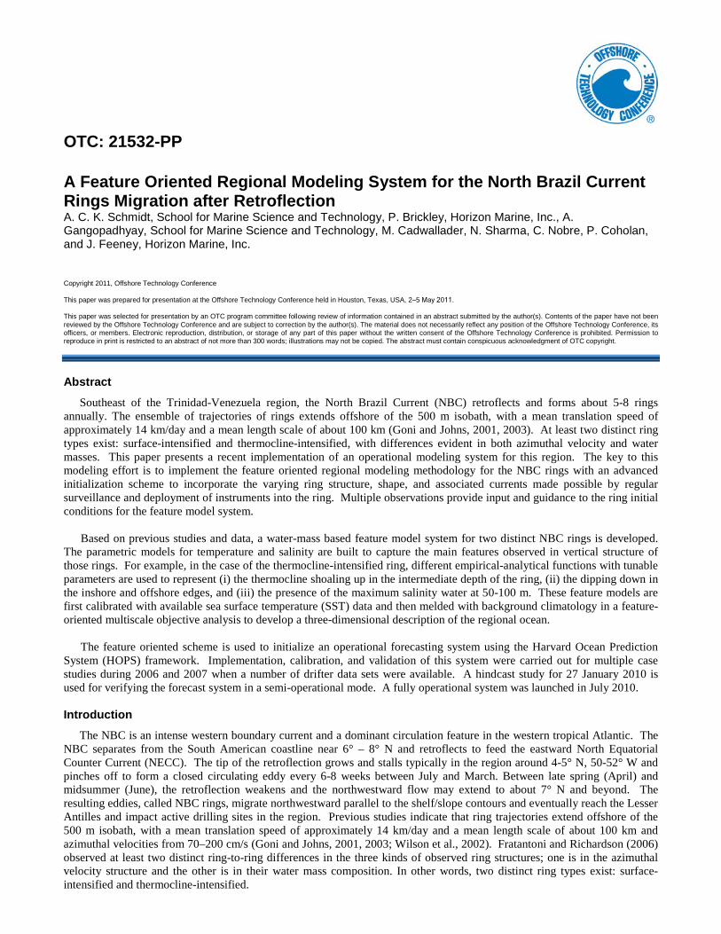
Figure 1 shows the weekly progression of a typical ring over a 3-month period during the NBC seasonal peak export in
boreal fall and winter. The ring’s outer extents are color coded to illustrate the progression. In the figure, the NBC Retroflection exhibits a progressive westward movement followed by a surge that culminates in a ring formation and separation. Following migration along the continental slope, the ring encounters the islands of Trinidad and Tobago and changes its course of migration to move northward. North of the island of Tobago, the rings eventually decompose in the vicinity of the Lesser Antilles.
OTC 21532-PP 3
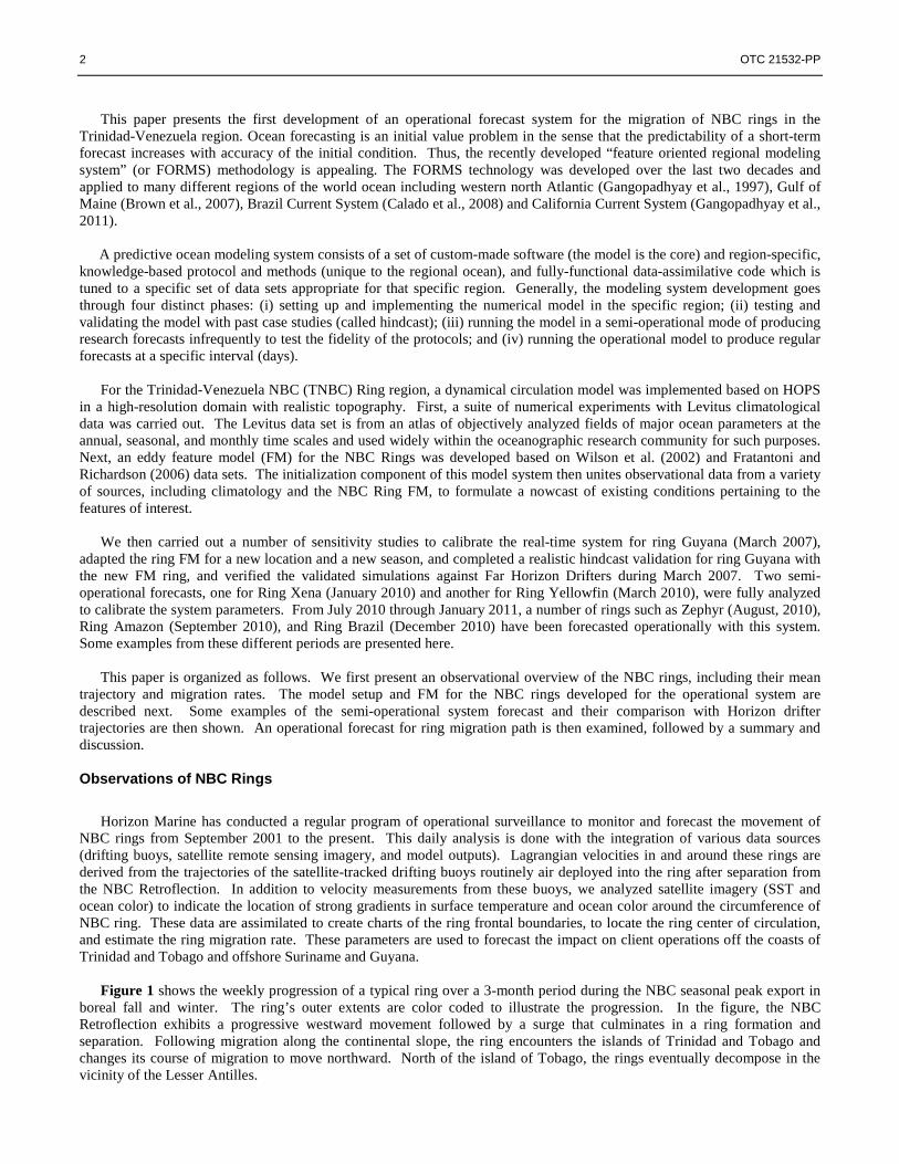
Observations of 44 distinct NBC rings over nine years from 2001 to 2010 support previous reports that, on average, the NBC retroflection sheds five to eight NBC rings each year. The dimensions for each ring (namely the center of circulation, major and minor axes, and orientation) were obtained by fitting perfect ellipses to the observed ring structure. These measurements were then used to calculate the average rate of migration, size, and orientation. Rings range from 150 to 400 km in diameter and exhibit asymmetrically organized azimuthal surface currents with speeds from 70 to 200 cm/s. These statistics are similar to previous studies in the region (Fratantoni et al., 1995, Goni and Johns, 2003, Fratantoni and Richardson, 2006). The migration paths followed by the 44 NBC rings determine a mean ring migration “corridor” illustrated in Figure 2. The average rate of migration along the entire path is approximately 14.8 km/day or 17.2 cm/s. The rate of migration during and immediately after separation is fairly slow for each ring as a result of its interaction with the plateau and weak connections with the NBC. Higher rates of migration are observed to the west of the Demerara Rise. The boundaries of the migration corridor traversed by the ring center of circulation span a relatively narrow geographic range relative to the ring diameter.
We have observed a continuous interaction of almost all rings with the shelf break throughout their lifetime after
formation over or near the Demerara Rise. A ring’s rotation decreases as it aligns itself parallel to the shelf break between the Demerara Rise and the shelf break off the east coast of Trinidad. Rings generally develop a distinct velocity asymmetry as they continuously interact with the shelf-slope topography. This asymmetric velocity structure was previously documented by Goni and Johns (2003) in their analysis of about 100 rings. The distance to the region of maximum velocity from the core is on the order of 125 km and to the edge of the ring is about 250 km. The transient velocity associated with rings in contact with the slope of South America episodically disrupts regional circulation, which is itself quite complex due to their proximity to freshwater sources of the Amazon and Orinoco. The Model Development
Operational Setup We have implemented the dynamical circulation model of the Harvard Ocean Prediction System (HOPS) in a high-
resolution domain. HOPS is an integrated system of data analysis and assimilation schemes and a suite of coupled interdisciplinary (physical, acoustical, optimal, biochemical-ecosystem) dynamical models (Robinson et al., 1998; Robinson et al., 2002). It is composed of various program packages and its core is a primitive equation (PE) physical dynamical circulation model. The dynamical model solves the primitive equations, assuming that the fluid is hydrostatic, Boussinesq approximation, open boundary conditions for velocity in the horizontal, no normal flow at the surface and bottom (rigid lid) in the vertical, and sub-grid scale processes are parameterized by a Shapiro filter.
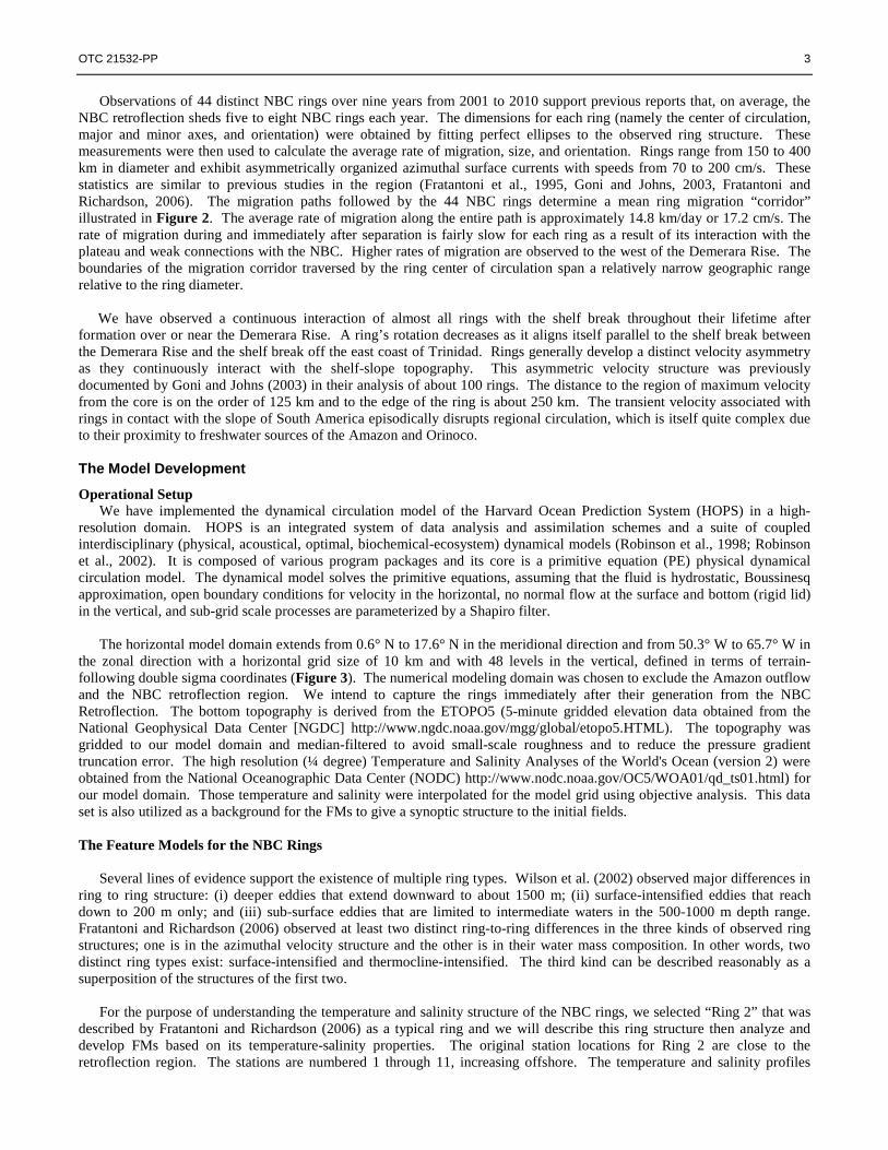
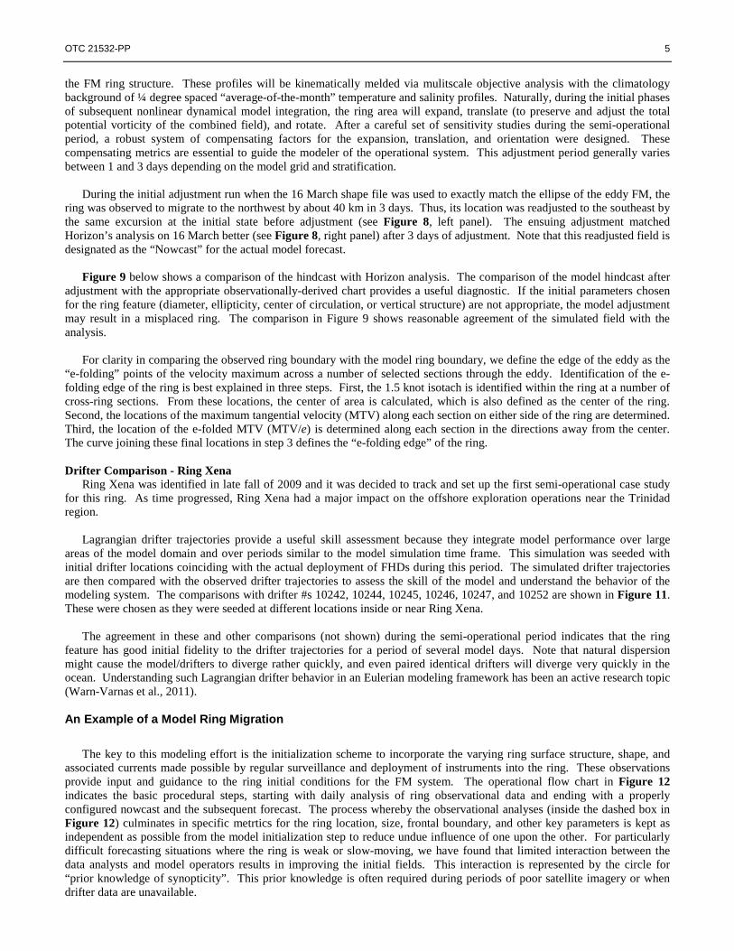
The horizontal model domain extends from 0.6° N to 17.6° N in the meridional direction and from 50.3° W to 65.7° W in
the zonal direction with a horizontal grid size of 10 km and with 48 levels in the vertical, defined in terms of terrain-following double sigma coordinates (Figure 3). The numerical modeling domain was chosen to exclude the Amazon outflow and the NBC retroflection region. We intend to capture the rings immediately after their generation from the NBC Retroflection. The bottom topography is derived from the ETOPO5 (5-minute gridded elevation data obtained from the National Geophysical Data Center [NGDC] http://www.ngdc.noaa.gov/mgg/global/etopo5.HTML). The topography was gridded to our model domain and median-filtered to avoid small-scale roughness and to reduce the pressure gradient truncation error. The high resolution (¼ degree) Temperature and Salinity Analyses of the World's Ocean (version 2) were obtained from the National Oceanographic Data Center (NODC) http://www.nodc.noaa.gov/OC5/WOA01/qd_ts01.html) for our model domain. Those temperature and salinity were interpolated for the model grid using objective analysis. This data set is also utilized as a background for the FMs to give a synoptic structure to the initial fields. The Feature Models for the NBC Rings
Several lines of evidence support the existence of multiple ring types. Wilson et al. (2002) observed major differences in
ring to ring structure: (i) deeper eddies that extend downward to about 1500 m; (ii) surface-intensified eddies that reach down to 200 m only; and (iii) sub-surface eddies that are limited to intermediate waters in the 500-1000 m depth range. Fratantoni and Richardson (2006) observed at least two distinct ring-to-ring differences in the three kinds of observed ring structures; one is in the azimuthal velocity structure and the other is in their water mass composition. In other words, two distinct ring types exist: surface-intensified and thermocline-intensified. The third kind can be described reasonably as a superposition of the structures of the first two.
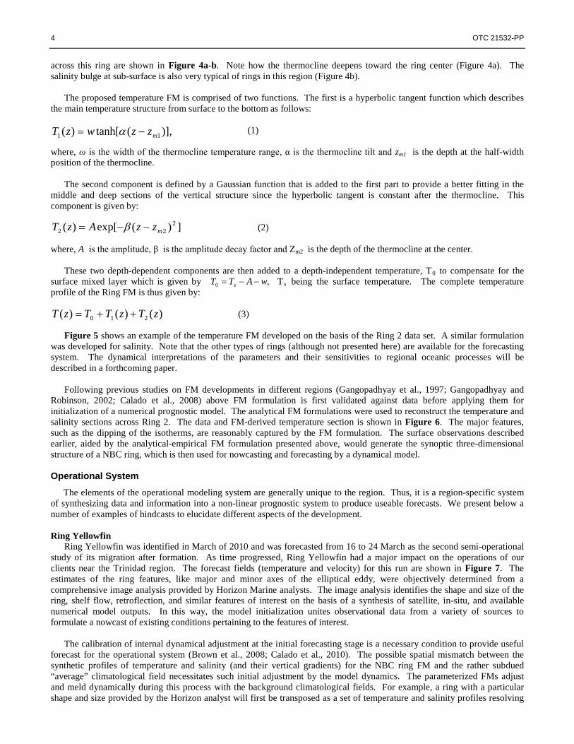
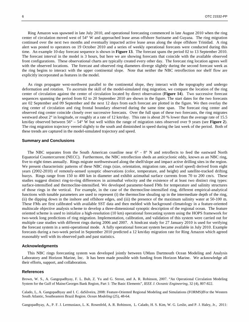
For the purpose of understanding the temperature and salinity structure of the NBC rings, we selected “Ring 2” that was
described by Fratantoni and Richardson (2006) as a typical ring and we will describe this ring structure then analyze and develop FMs based on its temperature-salinity properties. The original station locations for Ring 2 are close to the retroflection region. The stations are numbered 1 through 11, increasing offshore. The temperature and salinity profiles
4 OTC 21532-PP
,0 wATT s −−=
)],(tanh[)( 11 mzzwzT −= α
])(exp[)( 222 mzzAzT −−= β
)()()( 210 zTzTTzT ++=
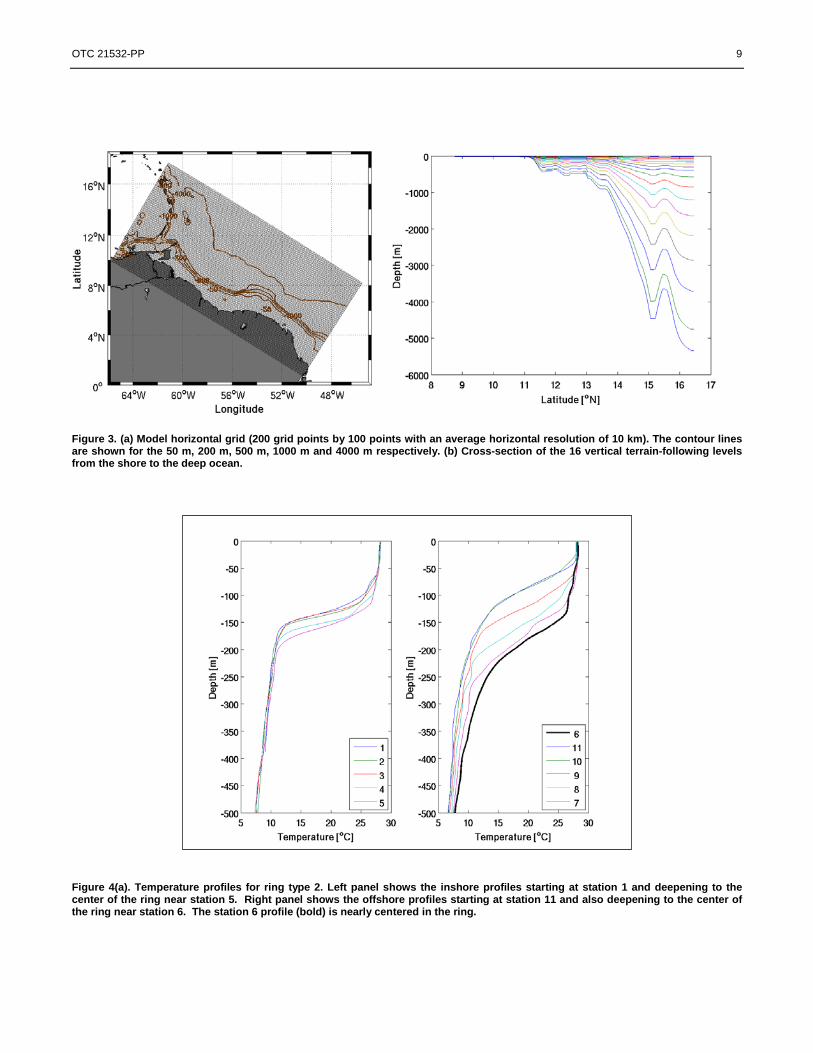
across this ring are shown in Figure 4a-b. Note how the thermocline deepens toward the ring center (Figure 4a). The salinity bulge at sub-surface is also very typical of rings in this region (Figure 4b).
The proposed temperature FM is comprised of two functions. The first is a hyperbolic tangent function which describes
the main temperature structure from surface to the bottom as follows:
(1)
where, ω is the width of the thermocline temperature range, α is the thermocline tilt and zm1 is the depth at the half-width position of the thermocline.
The second component is defined by a Gaussian function that is added to the first part to provide a better fitting in the middle and deep sections of the vertical structure since the hyperbolic tangent is constant after the thermocline. This component is given by:
(2)
where, A is the amplitude, β is the amplitude decay factor and Zm2 is the depth of the thermocline at the center.
These two depth-dependent components are then added to a depth-independent temperature, T0 to compensate for the surface mixed layer which is given by Ts
being the surface temperature. The complete temperature profile of the Ring FM is thus given by:
(3)
Figure 5 shows an example of the temperature FM developed on the basis of the Ring 2 data set. A similar formulation was developed for salinity. Note that the other types of rings (although not presented here) are available for the forecasting system. The dynamical interpretations of the parameters and their sensitivities to regional oceanic processes will be described in a forthcoming paper.
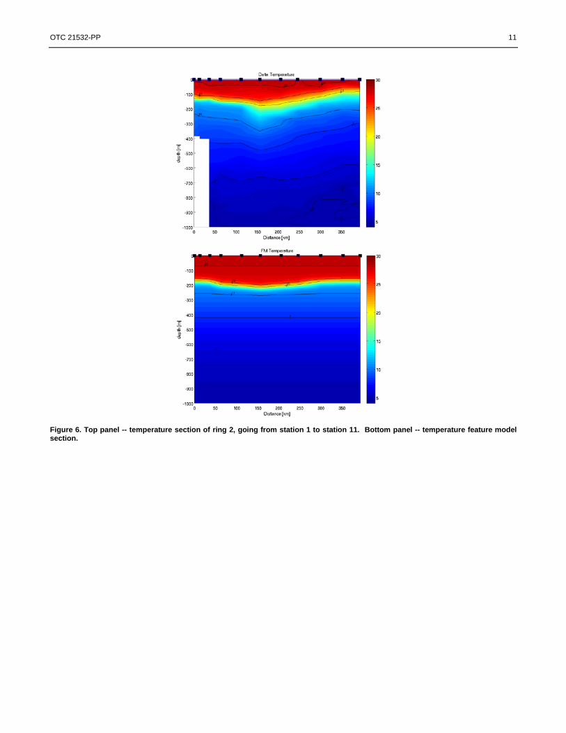
Following previous studies on FM developments in different regions (Gangopadhyay et al., 1997; Gangopadhyay and
Robinson, 2002; Calado et al., 2008) above FM formulation is first validated against data before applying them for initialization of a numerical prognostic model. The analytical FM formulations were used to reconstruct the temperature and salinity sections across Ring 2. The data and FM-derived temperature section is shown in Figure 6. The major features, such as the dipping of the isotherms, are reasonably captured by the FM formulation. The surface observations described earlier, aided by the analytical-empirical FM formulation presented above, would generate the synoptic three-dimensional structure of a NBC ring, which is then used for nowcasting and forecasting by a dynamical model. Operational System
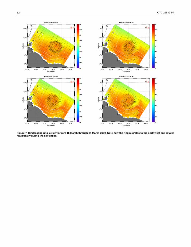
The elements of the operational modeling system are generally unique to the region. Thus, it is a region-specific system of synthesizing data and information into a non-linear prognostic system to produce useable forecasts. We present below a number of examples of hindcasts to elucidate different aspects of the development. Ring Yellowfin
Ring Yellowfin was identified in March of 2010 and was forecasted from 16 to 24 March as the second semi-operational study of its migration after formation. As time progressed, Ring Yellowfin had a major impact on the operations of our clients near the Trinidad region. The forecast fields (temperature and velocity) for this run are shown in Figure 7. The estimates of the ring features, like major and minor axes of the elliptical eddy, were objectively determined from a comprehensive image analysis provided by Horizon Marine analysts. The image analysis identifies the shape and size of the ring, shelf flow, retroflection, and similar features of interest on the basis of a synthesis of satellite, in-situ, and available numerical model outputs. In this way, the model initialization unites observational data from a variety of sources to formulate a nowcast of existing conditions pertaining to the features of interest.
The calibration of internal dynamical adjustment at the initial forecasting stage is a necessary condition to provide useful
forecast for the operational system (Brown et al., 2008; Calado et al., 2010). The possible spatial mismatch between the synthetic profiles of temperature and salinity (and their vertical gradients) for the NBC ring FM and the rather subdued “average” climatological field necessitates such initial adjustment by the model dynamics. The parameterized FMs adjust and meld dynamically during this process with the background climatological fields. For example, a ring with a particular shape and size provided by the Horizon analyst will first be transposed as a set of temperature and salinity profiles resolving
OTC 21532-PP 5
the FM ring structure. These profiles will be kinematically melded via mulitscale objective analysis with the climatology background of ¼ degree spaced “average-of-the-month” temperature and salinity profiles. Naturally, during the initial phases of subsequent nonlinear dynamical model integration, the ring area will expand, translate (to preserve and adjust the total potential vorticity of the combined field), and rotate. After a careful set of sensitivity studies during the semi-operational period, a robust system of compensating factors for the expansion, translation, and orientation were designed. These compensating metrics are essential to guide the modeler of the operational system. This adjustment period generally varies between 1 and 3 days depending on the model grid and stratification.
During the initial adjustment run when the 16 March shape file was used to exactly match the ellipse of the eddy FM, the
ring was observed to migrate to the northwest by about 40 km in 3 days. Thus, its location was readjusted to the southeast by the same excursion at the initial state before adjustment (see Figure 8, left panel). The ensuing adjustment matched Horizon’s analysis on 16 March better (see Figure 8, right panel) after 3 days of adjustment. Note that this readjusted field is designated as the “Nowcast” for the actual model forecast.
Figure 9 below shows a comparison of the hindcast with Horizon analysis. The comparison of the model hindcast after
adjustment with the appropriate observationally-derived chart provides a useful diagnostic. If the initial parameters chosen for the ring feature (diameter, ellipticity, center of circulation, or vertical structure) are not appropriate, the model adjustment may result in a misplaced ring. The comparison in Figure 9 shows reasonable agreement of the simulated field with the analysis.
For clarity in comparing the observed ring boundary with the model ring boundary, we define the edge of the eddy as the
“e-folding” points of the velocity maximum across a number of selected sections through the eddy. Identification of the e-folding edge of the ring is best explained in three steps. First, the 1.5 knot isotach is identified within the ring at a number of cross-ring sections. From these locations, the center of area is calculated, which is also defined as the center of the ring. Second, the locations of the maximum tangential velocity (MTV) along each section on either side of the ring are determined. Third, the location of the e-folded MTV (MTV/e) is determined along each section in the directions away from the center. The curve joining these final locations in step 3 defines the “e-folding edge” of the ring. Drifter Comparison - Ring Xena
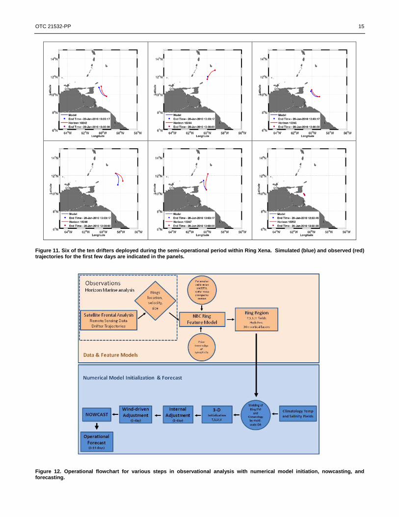
Ring Xena was identified in late fall of 2009 and it was decided to track and set up the first semi-operational case study for this ring. As time progressed, Ring Xena had a major impact on the offshore exploration operations near the Trinidad region.
Lagrangian drifter trajectories provide a useful skill assessment because they integrate model performance over large
areas of the model domain and over periods similar to the model simulation time frame. This simulation was seeded with initial drifter locations coinciding with the actual deployment of FHDs during this period. The simulated drifter trajectories are then compared with the observed drifter trajectories to assess the skill of the model and understand the behavior of the modeling system. The comparisons with drifter #s 10242, 10244, 10245, 10246, 10247, and 10252 are shown in Figure 11. These were chosen as they were seeded at different locations inside or near Ring Xena.
The agreement in these and other comparisons (not shown) during the semi-operational period indicates that the ring
feature has good initial fidelity to the drifter trajectories for a period of several model days. Note that natural dispersion might cause the model/drifters to diverge rather quickly, and even paired identical drifters will diverge very quickly in the ocean. Understanding such Lagrangian drifter behavior in an Eulerian modeling framework has been an active research topic (Warn-Varnas et al., 2011). An Example of a Model Ring Migration
The key to this modeling effort is the initialization scheme to incorporate the varying ring surface structure, shape, and
associated currents made possible by regular surveillance and deployment of instruments into the ring. These observations provide input and guidance to the ring initial conditions for the FM system. The operational flow chart in Figure 12 indicates the basic procedural steps, starting with daily analysis of ring observational data and ending with a properly configured nowcast and the subsequent forecast. The process whereby the observational analyses (inside the dashed box in Figure 12) culminates in specific metrtics for the ring location, size, frontal boundary, and other key parameters is kept as independent as possible from the model initialization step to reduce undue influence of one upon the other. For particularly difficult forecasting situations where the ring is weak or slow-moving, we have found that limited interaction between the data analysts and model operators results in improving the initial fields. This interaction is represented by the circle for “prior knowledge of synopticity”. This prior knowledge is often required during periods of poor satellite imagery or when drifter data are unavailable.
6 OTC 21532-PP
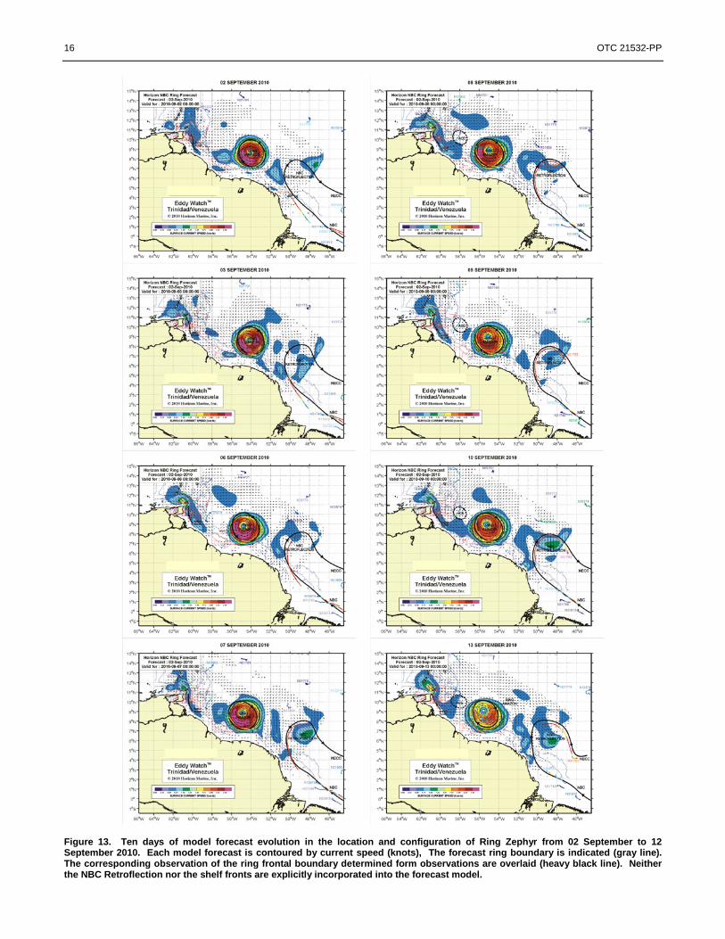
Ring Amazon was spawned in late July 2010, and operational forecasting commenced in late August 2010 when the ring
center of circulation moved west of 54° W and approached lease areas offshore Suriname and Guyana. The ring migration continued over the next two months and eventually impacted active lease areas along the slope offshore Trinidad. A ring alert was posted to operators on 19 October 2010 and a series of weekly operational forecasts were conducted during this time. An example 10-day forecast sequence is shown in Figure 13. The forecast spans the period 02 to 13 September 2010. The forecast interval in the model is 3 hours, but here we are showing forecasts that coincide with the available observed front configurations. These observational charts are typically created every other day. The forecast ring location agrees well with the observed locations. The forecast and observed ring diameters diverge slightly during the second forecast week as the ring begins to interact with the upper continental slope. Note that neither the NBC retroflection nor shelf flow are explicitly incorporated as features in the model.
As rings propagate west-northwest parallel to the continental slope, they interact with the topography and undergo
deformation and rotation. To ascertain the skill of the model-simulated ring migration, we compare the location of the ring center of circulation against the center of circulation located by direct observation (Figure 14). Two successive forecast sequences spanning the period from 02 to 20 September 2010 are shown in the figure. The start dates for the two forecasts are 02 September and 09 September and the next 12 days from each forecast are plotted in the figure. We then overlay the ring center of circulation and ring frontal boundary observed during the same time span. The forecast ring center and observed ring center coincide closely over successive forecasts. Over the full span of these two forecasts, the ring migrates westward about 2° in longitude, or roughly at a rate of 12 km/day. This rate is about 20 % lower than the average rate of 15.5 km/day observed between 56° – 54° W but well within the range of migration rates observed over 9 years (see Figure 2). The ring migration trajectory veered slightly to the south and diminished in speed during the last week of the period. Both of these trends are captured in the model-simulated trajectory and speed. Summary and Conclusions
The NBC separates from the South American coastline near 6° - 8° N and retroflects to feed the eastward North
Equatorial Countercurrent (NECC). Furthermore, the NBC retroflection sheds an anticyclonic eddy, known as an NBC ring, five to eight times annually. Rings migrate northwestward along the shelf/slope and impact active drilling sites in the region. We present characteristic patterns of these NBC rings (size, orientation, migration rate, and swirl speed) derived from eight years (2002-2010) of remotely-sensed synoptic observations (color, temperature, and height) and satellite-tracked drifting buoys. Rings range from 150 to 400 km in diameter and exhibit azimuthal surface currents from 70 to 200 cm/s. These studies suggest distinct ring-to-ring differences in azimuthal velocity and the existence of at least two distinct ring types: surface-intensified and thermocline-intensified. We developed parameter-based FMs for temperature and salinity structures of those rings in the vertical. For example, in the case of the thermocline-intensified ring, different empirical-analytical functions with tunable parameters are used to represent (i) the thermocline shoaling up in the intermediate depth of the ring, (ii) the dipping down in the inshore and offshore edges, and (iii) the presence of the maximum salinity water at 50-100 m. These FMs are first calibrated with available SST data and then melded with background climatology in a feature-oriented multiscale objective analysis scheme to develop a three-dimensional synoptic description of the regional ocean. The feature oriented scheme is used to initialize a high-resolution (10 km) operational forecasting system using the HOPS framework for two-week long predictions of ring migration. Implementation, calibration, and validation of this system were carried out for multiple case studies with different rings during 2006 and 2007. A hindcast study for 27 January 2010 is used for verifying the forecast system in a semi-operational mode. A fully operational forecast system became available in July 2010. Example forecasts during a two-week period in September 2010 predicted a 12 km/day migration rate for Ring Amazon which agreed reasonably well with its observed path and past statistics.
Acknowledgments
This NBC rings forecasting system was developed jointly between UMass Dartmouth Ocean Modeling and Analysis Laboratory and Horizon Marine, Inc. It has been made possible with funding from Horizon Marine. We acknowledge all their efforts, support, and collaboration. References
Brown, W. S., A. Gangopadhyay, F. L. Bub, Z. Yu and G. Strout, and A. R. Robinson, 2007. “An Operational Circulation Modeling System for the Gulf of Maine/Georges Bank Region, Part 1: The Basic Elements”, IEEE J. Oceanic Engineering, 32 (4), 807-822. Calado, L, A. Gangopadhyay and I. C. daSilveira, 2008: Feature-Oriented Regional Modeling and Simulations (FORMS)fFor the Western South Atlantic, Southeastern Brazil Region. Ocean Modeling (25), 48-64. Gangopadhyay, A., P. F. J. Lermusiaux, L. K. Rosenfeld, A. R. Robinson, L. Calado, H. S. Kim, W. G. Leslie, and P. J. Haley, Jr., 2011:

OTC 21532-PP 7
California Current System: A Multiscale Overview and the Development of a Feature-Oriented Regional Modeling System (FORMS), (Accepted, Dynamics of Atmosphere and Oceans). Gangopadhyay, A., and A. R. Robinson, 2002, Feature oriented regional modeling of oceanic fronts Dynamics of Atmospheres and Oceans, 36, 201-232. Gangopadhyay, A., A. R. Robinson, P. J. Haley, W. J. Leslie, C. J. Lozano, James J. Bisagni, and Z. Yu, 2003: Feature Oriented Regional Modeling and Simulation (FORMS) in the Gulf of Maine and Georges Bank, Cont. Shelf Res. 23(3-4), 317-353. Gangopadhyay, A., A. R. Robinson, and H.G. Arango, 1997: Circulation and Dynamics of the Western North Atlantic, I: Multiscale Feature Models. J. Atmos. Ocean.Tech., 14(6), 1314-1332. Goni, G. J. and W. E. Johns, 2001, 'A census of North Brazil Current rings observed from TOPEX/POSEIDON altimetry: 1992-1998', Geophysical Research Letters 28(1), 1-4. Goni, G. J. and W. E. Johns, 2003, 'Synoptic study of warm rings in the North Brazil Current retroflection region using satellite altimetry', Interhemispheric Water Exchange in the Atlantic Ocean 68, 335-356. Robinson, A. R., P. F. J. Lermusiaux, and N. Q. Sloan, 1998, Data Assimilation. In THE SEA: The Global Coastal Ocean, Volume 10: Processes and Methods (K. H. Brink and A. R. Robinson, eds.), John Wiley and Sons, NY, 541-594, 1998. Robinson, A. R., P. J. Haley, P. F. J. Lermusiaux and W. G. Leslie, 2002, Predictive skill, predictive capability and predictability in ocean forecasting (.pdf). Proceedings of ``The OCEANS 2002 MTS/IEEE'' conference, IEEE, Holland Publications, 787-794. Spall, M. A. and Robinson, A. R. 1989, A new open ocean, hybrid coordinate primitive equation model. Math. Comput. Simul. 31, 3 (Jul. 1989), 241-269. DOI= http://dx.doi.org/10.1016/0378-4754 (89)90162-6 Fratantoni, D. M. and D. A. Glickson, 2002, 'North Brazil current ring generation and evolution observed with SeaWiFS', Journal Of Physical Oceanography 32(3), 1058-1074. Fratantoni, D. M.; Johns, W. E. and T. L. Townsend, 1995, 'Rings Of The North Brazil Current - Their Structure And Behavior Inferred From Observations And A Numerical-Simulation', Journal Of Geophysical Research-Oceans 100(C6), 10633—10654. Fratantoni, D. M. and P. L. Richardson, 2006, 'The evolution and demise of North Brazil Current rings', Journal Of Physical Oceanography 36(7), 1241-1264. Richardson, P. L.; Hufford, G. E., Limeburner, R. and W. S. Brown, 1994, 'North Brazil Current Retroflection Eddies', Journal Of Geophysical Research-Oceans 99(C3), 5081-5093. Wilson, W. D.; Johns, W. E. and S. L. Garzoli, 2002, 'Velocity structure of North Brazil Current rings', Geophysical Research Letters 29(8). Warn-Varnas, A., Gangopadhyay, A., Schmidt, A. C. K., and Jensen, J-K., 2011, Nonlinear studies of Norwegian Coastal Current from Eulerian and Lagrangian point of views, European Geophysical Union Meeting, Vienna, March, 2011.

8 OTC 21532-PP
Figure 1. Example NBC Ring progression to the northwest parallel to the northern coast of South America shown as elliptical fits to ring fronts and the center of circulation. The rings are color coded from light green to black with the lighter shades corresponding to the beginning of the sample period and the darker colors to the later weeks. The orange line represents the mean trajectory followed by the ring centers over time. Dotted fronts indicate a lower level of confidence in the placement due to poor satellite imagery and/or lack of buoy coverage at the time.
Figure 2. Mean trajectory of 44 NBC rings tracked in this study. The standard deviation is shown in green. Observational statistics are noted for the average rate of migration at 2° longitude intervals, and over the entire longitudinal range of the ring “corridor”.
OTC 21532-PP 9
(c)
Figure 3. (a) Model horizontal grid (200 grid points by 100 points with an average horizontal resolution of 10 km). The contour lines are shown for the 50 m, 200 m, 500 m, 1000 m and 4000 m respectively. (b) Cross-section of the 16 vertical terrain-following levels from the shore to the deep ocean.
Figure 4(a). Temperature profiles for ring type 2. Left panel shows the inshore profiles starting at station 1 and deepening to the center of the ring near station 5. Right panel shows the offshore profiles starting at station 11 and also deepening to the center of the ring near station 6. The station 6 profile (bold) is nearly centered in the ring.
10 OTC 21532-PP
Figure 4(b). Salinity profiles associated with ring type 2. The profile order is described in Figure 4(a).
Figure 5 - Temperature Feature Model Schematic. Shown are different components. The final profile is shown on the right. The parameter values are: T0 = 13.5 °C; w=8.2; Zm1 = -175 m; α = 0.045; A = 6.8; β = α /10000; and Zm2
= 0.
OTC 21532-PP 11
Figure 6. Top panel -- temperature section of ring 2, going from station 1 to station 11. Bottom panel -- temperature feature model section.
12 OTC 21532-PP
Figure 7. Hindcasting ring Yellowfin from 16 March through 24 March 2010. Note how the ring migrates to the northwest and rotates realistically during the simulation.

OTC 21532-PP 13
Figure 8. Three-day initial adjustment of Ring Yellowfin with southeastward shift before the nowcast. The red lines are the outer and inner isotachs (0.82 m/sec) within the modeled eddy. The black lines are for the same day (16 March 2010) in all four panels. Note how the model red lines adjust to the black analysis during this internal adjustment period. With a better definition of the red-line and wind-adjustment, we hope to improve the nowcast (right-bottom) further during operational runs.

14 OTC 21532-PP
Figure 9. Comparison of the e-folding edges (red) with the isotach (green) edges of the ring evolution. Note that the area within the red contour is generally larger than the area covered by the green contour, indicating a larger probability of capturing the ring while evolving in time (and being diffused) during the simulation. The black line is Horizon’s delineation of the ring boundary.
OTC 21532-PP 15
Figure 11. Six of the ten drifters deployed during the semi-operational period within Ring Xena. Simulated (blue) and observed (red) trajectories for the first few days are indicated in the panels.
Figure 12. Operational flowchart for various steps in observational analysis with numerical model initiation, nowcasting, and forecasting.
16 OTC 21532-PP
Figure 13. Ten days of model forecast evolution in the location and configuration of Ring Zephyr from 02 September to 12 September 2010. Each model forecast is contoured by current speed (knots), The forecast ring boundary is indicated (gray line). The corresponding observation of the ring frontal boundary determined form observations are overlaid (heavy black line). Neither the NBC Retroflection nor the shelf fronts are explicitly incorporated into the forecast model.

OTC 21532-PP 17
Figure 14. Progression of forecast ring center of circulation compared to the observed ring center (green dots) during 02 – 20 September 2010. Two successive forecast periods are combined in the figure: 02 – 13 and 09 – 20 September 2010 (red and magenta dots, respectively). The available observed ring frontal boundaries are included (gray). The 200 and 2000 m isobaths are indicated (blue).