Embed Size (px)
Citation preview
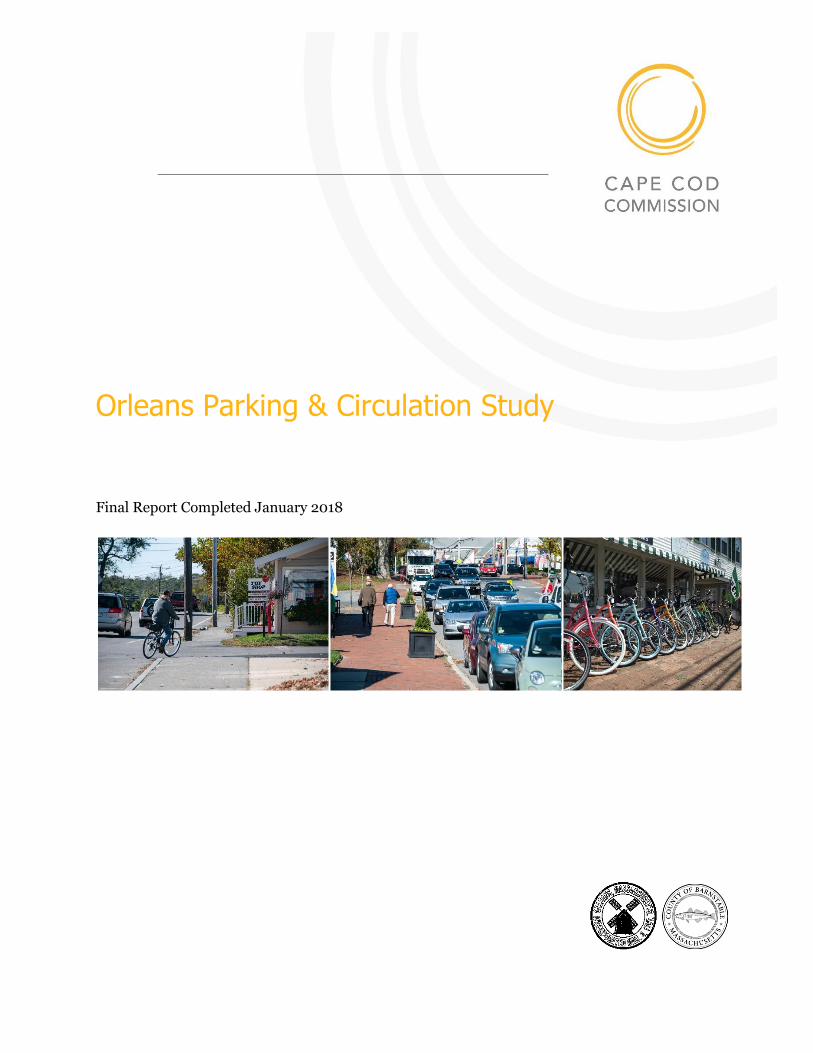
Orleans Parking & Circulation Study
Final Report Completed January 2018

Orleans Parking & Circulation Study Final Report
Table of Contents
Executive Summary ................................................................................ 1 Study Scope........................................................................................... 4
Introduction ............................................................................................................... 4
Planning Context ........................................................................................................ 4
Project Goal ............................................................................................................... 5
Research Questions .................................................................................................... 5
Background ........................................................................................... 6
Previous Studies ......................................................................................................... 6
Planning & Regulatory Context ................................................................................... 10
Existing Conditions ............................................................................... 14
Parking Assessment ................................................................................................... 14
Circulation Assessment............................................................................................... 24
Growth Impact Assessment ................................................................... 32
Development Effects on Parking Demand..................................................................... 35
Development Effects on Intersection Performance ........................................................ 35
Summary of Findings & Next Steps ........................................................ 38
Summary of Findings ................................................................................................. 38
Recommended Next Steps .......................................................................................... 38
Appendices .......................................................................................... 54
Appendix 1 - Scope of Work – Tasks & Project Team .................................................... 54
Appendix 2 - Recommendation from Previous Studies ................................................... 57
Appendix 3 - Side-by-Side Zoning Comparison ............................................................. 62
Appendix 4 - Parking Occupancy Data and Maps .......................................................... 68
Appendix 5 – Examples of Cooperative Parking Agreements .......................................... 73
Appendix 6 – Ciculation Next Steps Map ...................................................................... 79

Orleans Parking & Circulation Study Final Report
Orleans Parking & Circulation Study Final Report Page 1
Executive Summary
PURPOSE/GOAL
The goal of this project was to identify improvements to parking and circulation
that would increase safety for pedestrians, bicyclists and vehicle drivers, while at
the same time encourage commerce, and enhance community character in the
core of the Orleans Village Center.
FINDINGS
Like previous studies focused on the Orleans Village Center, this study did not
find significant problems but does identify parking and circulation
improvements that would benefit all modes of transportation and result in a
more efficient and historically appropriate development pattern.
The parking inventory and occupancy counts show enough parking to
accommodate current levels of business activity throughout the day and evening
in both the off-season and summer peak. Only two locations reach capacity
during the summer peak - the parking lot behind the Hot Chocolate
Sparrow/CVS during the day and, in the evenings, the lots behind Land Ho!. The
study suggests addressing this spot congestion with better signage and by
redesigning key lots to improve function and capacity.
In terms of circulation, the Orleans Village Center is working appropriately for a
safe, walkable town center able to accommodate all modes of travel. The
intersection upgrades on Main Street at Route 6A and at Route 28 currently
underway, should further improve safety and efficiency for pedestrians, cyclists,
and motorists. Potential additions of housing in the village center can be
expected to increase pedestrians and bicycle use while only marginally increasing
auto congestion. Next steps for the Town to consider focusing on are the few
remaining intersections that challenge travelers, increasing internal circulation,
and making safety improvements.
Page 2 Orleans Parking & Circulation Study Final Report
NEXT STEPS
This report suggests six next steps for the Town to pursue as it continues to
improve parking and safe, efficient circulation in the Orleans Village Center while
preparing the area for in-fill growth in the future.
The three parking next steps are:
1. Parking Lot Design & Signage Improvements
As recommended in the Cape Cod Commission’s 2011 Village Center Streetscape
Plan, the Town should identify strategic sign locations and use wayfinding tools
to direct drivers to currently under-utilized parking and help pedestrians
circulate once they have parked. The study included three concept plans to
stimulate discussion on how lot design, landscaping, and coordinated lot
management can improve parking distribution, use, and safety.
2. Business Improvement District Adoption
As recommended in the 2015 Route 6A RESET Study, the Town should consider,
with the Village Center businesses and stakeholder groups, the establishment of a
Business Improvement District to implement many of the recommendations in
this and previous studies focused on the Village Center.
3. Parking Regulation Updates
The Town should consider updating the parking regulations for the Village
Center to be consistent with current best practices. Changes to consider include
1) replacing minimum parking requirements with maximum parking standards
or with a range of minimum/maximum standards; (2) revising shared parking
and “fee in lieu of” provisions so they will be used more often, and 3) improving
the viability of non-motorized modes of travel within the village by providing
better interconnections and accommodations for cyclists and pedestrians.
The three circulation related next steps suggested are:
1. Intersection Improvements
Intersection performance in the village is generally good and will be improved
with Massachusetts Department of Transporation’s redesign of the Route
28/Main Street Intersection, the Route 6A/Main Street intersection and the
alterations to Brewster Cross Road/Main Street intersection as part of the
Orleans Parking & Circulation Study Final Report Page 3
streetscape improvements to be completed soon. As a next step after these
projects are completed, the Town may want to address the Old Colony Way/Main
Street/Rail Trail intersection to improve performance and safety. The report
provides several options to consider for improving this intersection. Short and
long-term improvements to the Brewster Cross Road/Route 6A intersection are
also recommended.
2. Create New Connections, Complete Sidewalks and Cross Walks
With the goal of making Orleans a walkable village and reducing pressure on
existing intersections, this report recommends creating new connections between
main roads and completing the sidewalk and cross walk network. The suggested
connections break up large blocks, opening up new opportunities for traditional
village style and scaled redevelopment, as well as improving the circulation
options for pedestrians, bicyclists, and motorists.
3. Redesign and Eliminate Curb Cuts
A relatively straightforward way of improving safety and circulation is to redesign
or eliminate non-essential curb cuts. There are a number of overly wide curb cuts
identified in the report that could be redesigned to improve safety for both
pedestrians and motorists. The report also identifies curb cuts that could be
eliminated without limiting access and others that, should property owners agree
to joint access, could be eliminated. The inter-connections suggested would also
allow the elimination of curb cuts on the main roads and create new intersections
aligned with existing roads.
Page 4 Orleans Parking & Circulation Study Final Report
Study Scope
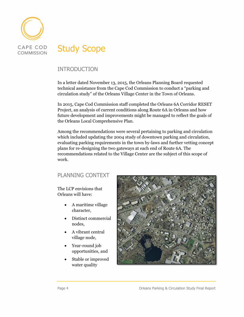
INTRODUCTION
In a letter dated November 13, 2015, the Orleans Planning Board requested
technical assistance from the Cape Cod Commission to conduct a “parking and
circulation study” of the Orleans Village Center in the Town of Orleans.
In 2015, Cape Cod Commission staff completed the Orleans 6A Corridor RESET
Project, an analysis of current conditions along Route 6A in Orleans and how
future development and improvements might be managed to reflect the goals of
the Orleans Local Comprehensive Plan.
Among the recommendations were several pertaining to parking and circulation
which included updating the 2004 study of downtown parking and circulation,
evaluating parking requirements in the town by-laws and further vetting concept
plans for re-designing the two gateways at each end of Route 6A. The
recommendations related to the Village Center are the subject of this scope of
work.
PLANNING CONTEXT
The LCP envisions that
Orleans will have:
• A maritime village
character,
• Distinct commercial
nodes,
• A vibrant central
village node,
• Year-round job
opportunities, and
• Stable or improved
water quality
Orleans Parking & Circulation Study Final Report Page 5
PROJECT GOAL
The goal of this project was to identify improvements to parking and circulation
that will increase safety for pedestrians, bicyclists and vehicle drivers, encourage
commerce, and enhance community character in the Village Center.
RESEARCH QUESTIONS
This report is organized by the following research questions the town requested
CCC address in the study:
• What is the total available parking spaces in the Village Center, both on-
street and off-street? How much is public? How much is private?
• What is the current level of parking use by location at different times of
day in the spring and the summer peak hours?
• How many businesses have the amount of parking required by the zoning
by-law? How many depend entirely on public parking?
• Does the zoning by-law require more parking than necessary? Are the
incentives for shared parking and in-lieu of parking payments sufficient?
Are there alternative best practices that should be considered in revising
the parking regulations?
• How well are intersections in the Village Center working for cars, bikes,
and pedestrians in terms of safety and time delay at intersections? How
do they perform at different times of day in the spring and the summer
peak?
• How will future development affect parking demand and intersection
performance in the Village Center?
The specific tasks and project team members are listed in Appendix 1.
Page 6 Orleans Parking & Circulation Study Final Report
Background
PREVIOUS STUDIES
A variety of studies focused on the Village Center have been completed over the
past 15 years that contain relevant findings and recommendations to this study.
Staff reviewed the following studies to inform our research, place our findings in
context, and form a short list of next steps for the Town relative to parking and
circulation in the Orleans Village Center:
• 2004 Parking and Circulation Study (Nitsch Engineering)
• 2011 Village Center Streetscape Plan (CC Commission)
• 2015 Route 6A Corridor RESET Project (CC Commission)
• 2014 Cape-wide Market Studies (Chesapeake)
• 2010 Economic Analysis of the Village Center (FinePoint)
• 2015 Orleans Town Center Economic Analysis (FinePoint)
The key findings and/or recommendations for each of these studies is included in
Appendix 2.
2004 PARKING AND CIRCULATION STUDY
Judith Nitsch Engineering Inc. evaluated traffic circulation and parking
conditions in the Orleans Village Center over the spring and summer of 2003.
They used this data to forecast conditions in 2008 and 2013. Notable conditions
in 2003 included:
• Traffic volumes peak between 3:45 and 4:45 pm daily
• All signalized intersection operated at acceptable levels of service during
the summer peak
• The crash rate at the Main Street/Old Colony Way intersection exceeded
state and district averages
• The vast majority of bicyclists (81%) stay on rail trail
• The majority of parking is in private off-street lots
Orleans Parking & Circulation Study Final Report Page 7
• The only lots that have ever reached capacity were those proximate to
Land-Ho!
The report included a series of short and longer-term recommendations (see
Appendix 2) that focused on improving circulation and safety, particularly for
pedestrians. The report also recommended that the Town purchase off-street
parking areas and improve their configuration and signage.
VILLAGE CENTER STREETSCAPE PLAN
At the Town’s request, the Cape Cod Commission conducted a planning and
design study of Orleans Village Center involving community workshops and
detailed site assessments. The goals of the study included:
• Recommend streetscape design guidelines and detailed specifications for
street level improvements to improve the pedestrian experience
• Provide conceptual site plans, renderings and visualizations depicting
recommendations for specific areas and elements
• Align streetscape improvements with the Town’s economic development
goals for the Village Center, the Cape Cod Commission’s Regional
Transportation Plan and the goals of the Regional Policy Plan
The plan recommended several improvements relevant to this study:
• Improve pedestrian comfort through increased landscaping, elimination
of “missing teeth” created by parking in front, and the addition of street
furniture
• Improve inter-connections through the creation of a pedestrian walkway
linking Main Street and Cove Road and the addition of way-finding
signage
The plan also recommended that the Town further investigate parking concerns
in the downtown to determine if there is a supply problem or just a
distribution/location problem.
ROUTE 6A CORRIDOR RESET PROJECT
In 2014, the Town requested a more comprehensive look at the Route 6A
Corridor relative to the Town's community and economic development goals
Page 8 Orleans Parking & Circulation Study Final Report
articulated in their 2006 Local Comprehensive Plan (LCP) by the Cape Cod
Commission. The study was comprehensive, evaluating how well the LCP goals
were reflected in the existing roadway conditions, land uses, building and
streetscape character and town by-laws.
Relevant to this study, the RESET project identified inconsistencies between
community goals relative to character and economic development goals with the
existing parking patterns and policies:
• Location of on-site parking in front of buildings
• Multiple indistinct curb cuts
• Excess parking; poorly located parking
• Cost of on-site parking as a disincentive for investment
Similarly, the study identified inconsistencies between circulation conditions and
community goals in the following areas:
• Risks to bicyclists and pedestrians:
▪ Poor sidewalk conditions and narrow sidewalk
▪ Lack of vegetated barrier or on-street parking between main roads
and sidewalks
▪ Signage for bike on road surface and for way-finding
▪ Poor visibility of bicyclists and pedestrians for auto drivers
• Impediments to traffic flow:
▪ Multiple indistinct curb cuts
▪ Lack of visibility at certain intersections
MARKET STUDIES – CAPE-WIDE & ORLEANS VILLAGE CENTER
A number of market studies have been conducted to better understand the
growth potential both in Orleans and for the Cape as a whole. While these
studies do not provide data directly used to evaluate parking and circulation in
the Orleans Village Center, they provide a necessary context for projecting future
conditions.
The Cape-wide Market Study found very limited future demand for commercial
services on Cape Cod over the next thirty years due to several factors:
Orleans Parking & Circulation Study Final Report Page 9
• Recent population declines and aging resident population
• Limited available land and development potential under current zoning
• Increasing development and living costs
• Seasonal nature of the regional economy
• Labor availability and costs to meet seasonal demands
The two economic studies of the Orleans Village Center completed by FinePoint
in 2010 and 2015 found that:
• Current retail demand is satisfied
• Any additional commercial activity will require an increase in demand
(i.e. customers/population)
• Barriers to further growth include:
▪ Cost of housing
▪ Limited housing variety
▪ Lack of rental housing
• Opportunities to facilitate growth include:
▪ Entry-level housing
▪ Housing maintenance business niche
SUMMARY OF PREVIOUS STUDES
Overall, previous studies focused on the Orleans Village Center did not find
significant problems relative to parking or circulation but identify measures to
improve conditions for pedestrian, facilitate multimodal transportation, and
advance safety. Many of the recommendations, where followed, could also
result in a more efficient use of the available land and improve the level of
social interaction and business activity in the study area. The
recommendations made in these reports are itemized in Appendix 2.
Page 10 Orleans Parking & Circulation Study Final Report
PLANNING & REGULATORY CONTEXT
2006 LOCAL COMPREHENSIVE PLAN
CCC staff reviewed the goals and policies within the 2006 Local Comprehensive
Plan relevant to parking and circulation in the Orleans Village Center. Important
policies in Section 9.2 Transportation Goals & Policies included:
• Traffic improvement measures should be designed with sensitivity to
seasonal variations in traffic patterns. However, roadway design should
reflect year-round traffic demands, and the Town should develop other
management strategies to address peak seasonal traffic flow.
• Existing transportation rights-of-way should be preserved for
transportation uses, including bicycle and pedestrian access ways.
• Mixed use development that minimizes dependence on the automobile
should be encouraged.
The LCP also identified a number of action steps relating to parking and
circulation including the following:
• Through the Capital Budgeting Program, the Town should acquire the
Besse Lot, which is located on Main Street, behind the Hogan Art Gallery
and Honey Candles. Access-only should be provided from Main Street
and full access/egress should be provided on Brewster Cross Road;
• Public Lots: Make better use of existing lots such as Nauset Middle School
to help people access the downtown.
• Make connection between lots (public and private) so that people can
move from a “full” lot to the next lot without driving on the street.
• To reduce demand for parking: enhance opportunities to use alternative
modes of transportation so that people can access the downtown without
cars.
• The town should incorporate land acquisition plan into its capital
planning to fund purchase of municipal parking space. If new municipal
spaces were created, Main Street on-street parking could be removed and
converted to bike lanes.
• Re-evaluate parking regulations in the Zoning Bylaws in order to assure
that the location, number, size, and screening of parking lots is
Orleans Parking & Circulation Study Final Report Page 11
appropriate, and to promote shared driveways and internal connections
between parking lots.
• Acquire land in strategic locations for better traffic and parking
management in the downtown area.
The short-list of action steps recommended in this study reflect the goals of the
LCP and many of its recommendations regarding parking and circulation.
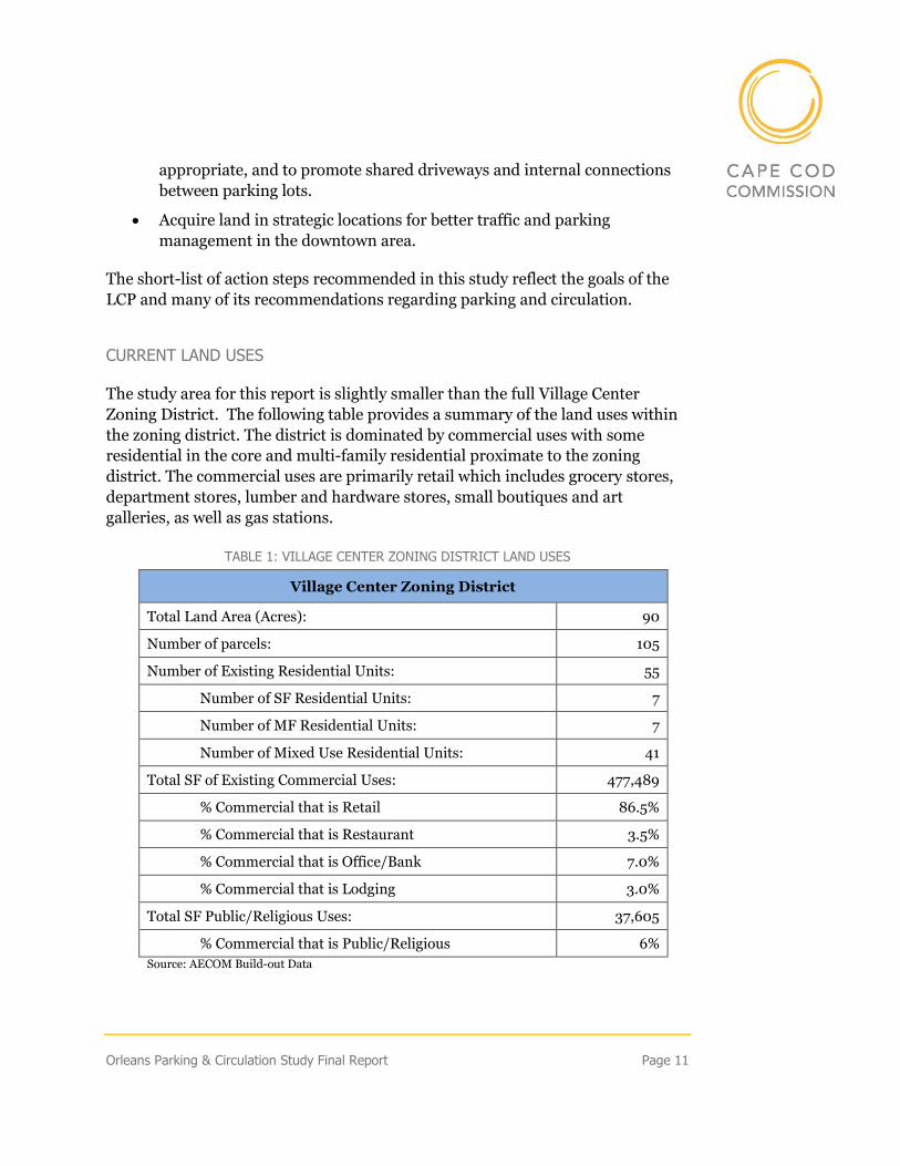
CURRENT LAND USES
The study area for this report is slightly smaller than the full Village Center
Zoning District. The following table provides a summary of the land uses within
the zoning district. The district is dominated by commercial uses with some
residential in the core and multi-family residential proximate to the zoning
district. The commercial uses are primarily retail which includes grocery stores,
department stores, lumber and hardware stores, small boutiques and art
galleries, as well as gas stations.
TABLE 1: VILLAGE CENTER ZONING DISTRICT LAND USES
Village Center Zoning District
Total Land Area (Acres): 90
Number of parcels: 105
Number of Existing Residential Units: 55
Number of SF Residential Units: 7
Number of MF Residential Units: 7
Number of Mixed Use Residential Units: 41
Total SF of Existing Commercial Uses: 477,489
% Commercial that is Retail 86.5%
% Commercial that is Restaurant 3.5%
% Commercial that is Office/Bank 7.0%
% Commercial that is Lodging 3.0%
Total SF Public/Religious Uses: 37,605
% Commercial that is Public/Religious 6%
Source: AECOM Build-out Data
Page 12 Orleans Parking & Circulation Study Final Report
ZONING
The Orleans zoning code establishes the permitted uses, building and site
dimensions, housing unit density, and parking requirements for new or
redevelopment in the Village Center. The specific elements of the newly updated
zoning by-law for the Village Center are outlined in a table in Appendix 3. The
table contrasts the zoning at the time the study was conducted, and the new
zoning adopted by Town Meeting in May 2017.
The recent AECom build out estimates for residential units indicate that, under
the old zoning, up to about 400 units could be built in the Village Center. Under
the zoning change made in May, up to about 670 units could be built in the
Village Center – in both cases without accounting for nitrogen limitations. The
new zoning also doubled the number of residential units that could be built in the
other two businesses districts along Route 6A from 870 to almost 2,000 units.
The zoning change did not alter the amount of commercial square feet permitted
in any of the three districts.
The 6A Corridor Study (2015) completed by the Cape Cod Commission RESET
team made a number of recommendations for zoning changes that if adopted that
could affect traffic patterns and parking location and supply:
• Differentiate allowed uses, dimensional standards and density by zoning
district
• Consolidate retail and service uses but differentiate office uses based on
differences in impacts
• Prohibit industrial/manufacturing uses from the village center
• Expand development permitted by-right to encourage desired uses
• Revise mixed use provision to encourage, rather than discourage, use
• Reduce minimum lot sizes and increase density permitted in village
center
• Reduce or eliminate parking requirements in village center; consider
developing new provisions to encourage shared parking; and consider
updating fee in lieu of parking provision.
Orleans Parking & Circulation Study Final Report Page 13
SUMMARY OF REGULATORY CONTEXT
The Orleans Local Comprehensive Plan (LCP) supports the development of a
mixed use, vibrant village center and reduced dependence on automobile
transportation. The Plan includes action steps aimed at increasing the use of
existing parking and creating strategic interconnects for parking and
circulation. The Plan also stresses that “roadway design should reflect year-
round traffic demands, and the Town should develop other management
strategies to address peak seasonal traffic flow.”
As new development and redevelopment occurs in the Village Center, the town
should consider revising the parking requirement in the zoning code to better
reflect the vision outlined in the LCP (suggestions are included in the final
chapter of this report).
In an effort to be equitable, the Town extended the recent zoning changes
beyond the Village Center district and is planning to provide sewer beyond the
Village Center as well. This decision could undermine the LCP goal of
establishing a vibrant village core and creating distinct nodes along Route 6A
of commercial activity with residential, and residentially based businesses, in
between.
Page 14 Orleans Parking & Circulation Study Final Report
Existing Conditions
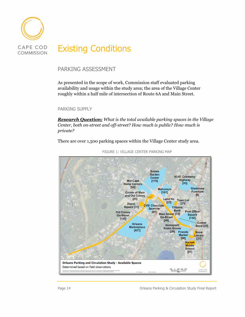
PARKING ASSESSMENT
As presented in the scope of work, Commission staff evaluated parking
availability and usage within the study area; the area of the Village Center
roughly within a half mile of intersection of Route 6A and Main Street.
PARKING SUPPLY
Research Question: What is the total available parking spaces in the Village
Center, both on-street and off-street? How much is public? How much is
private?
There are over 1,500 parking spaces within the Village Center study area.
FIGURE 1: VILLAGE CENTER PARKING MAP
Orleans Parking & Circulation Study Final Report Page 15
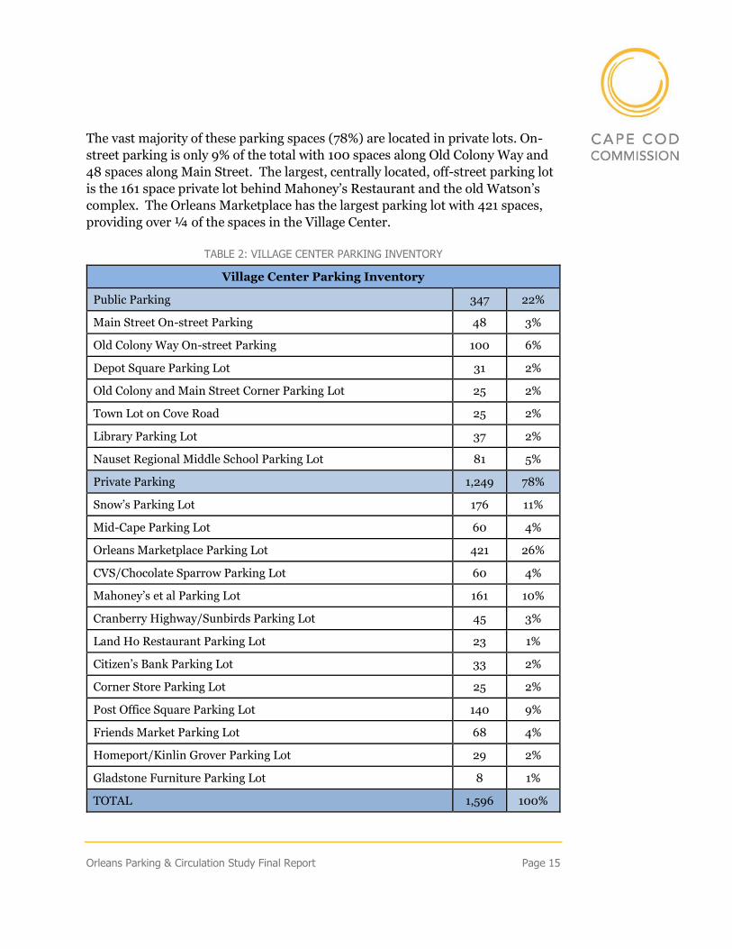
The vast majority of these parking spaces (78%) are located in private lots. On-
street parking is only 9% of the total with 100 spaces along Old Colony Way and
48 spaces along Main Street. The largest, centrally located, off-street parking lot
is the 161 space private lot behind Mahoney’s Restaurant and the old Watson’s
complex. The Orleans Marketplace has the largest parking lot with 421 spaces,
providing over ¼ of the spaces in the Village Center.
TABLE 2: VILLAGE CENTER PARKING INVENTORY
Village Center Parking Inventory
Public Parking 347 22%
Main Street On-street Parking 48 3%
Old Colony Way On-street Parking 100 6%
Depot Square Parking Lot 31 2%
Old Colony and Main Street Corner Parking Lot 25 2%
Town Lot on Cove Road 25 2%
Library Parking Lot 37 2%
Nauset Regional Middle School Parking Lot 81 5%
Private Parking 1,249 78%
Snow’s Parking Lot 176 11%
Mid-Cape Parking Lot 60 4%
Orleans Marketplace Parking Lot 421 26%
CVS/Chocolate Sparrow Parking Lot 60 4%
Mahoney’s et al Parking Lot 161 10%
Cranberry Highway/Sunbirds Parking Lot 45 3%
Land Ho Restaurant Parking Lot 23 1%
Citizen’s Bank Parking Lot 33 2%
Corner Store Parking Lot 25 2%
Post Office Square Parking Lot 140 9%
Friends Market Parking Lot 68 4%
Homeport/Kinlin Grover Parking Lot 29 2%
Gladstone Furniture Parking Lot 8 1%
TOTAL 1,596 100%
Page 16 Orleans Parking & Circulation Study Final Report
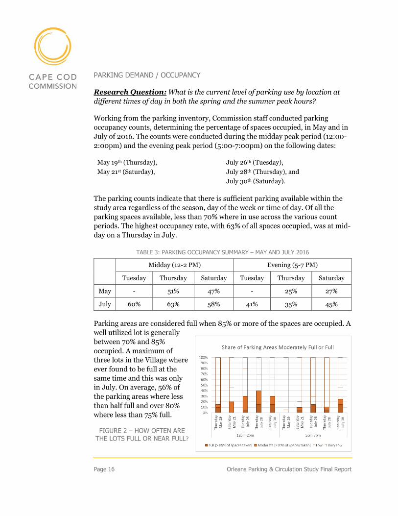
PARKING DEMAND / OCCUPANCY
Research Question: What is the current level of parking use by location at
different times of day in both the spring and the summer peak hours?
Working from the parking inventory, Commission staff conducted parking
occupancy counts, determining the percentage of spaces occupied, in May and in
July of 2016. The counts were conducted during the midday peak period (12:00-
2:00pm) and the evening peak period (5:00-7:00pm) on the following dates:
May 19th (Thursday), July 26th (Tuesday),
May 21st (Saturday), July 28th (Thursday), and
July 30th (Saturday).
The parking counts indicate that there is sufficient parking available within the
study area regardless of the season, day of the week or time of day. Of all the
parking spaces available, less than 70% where in use across the various count
periods. The highest occupancy rate, with 63% of all spaces occupied, was at mid-
day on a Thursday in July.
TABLE 3: PARKING OCCUPANCY SUMMARY – MAY AND JULY 2016
Midday (12-2 PM) Evening (5-7 PM)
Tuesday Thursday Saturday Tuesday Thursday Saturday
May - 51% 47% - 25% 27%
July 60% 63% 58% 41% 35% 45%
Parking areas are considered full when 85% or more of the spaces are occupied. A
well utilized lot is generally
between 70% and 85%
occupied. A maximum of
three lots in the Village where
ever found to be full at the
same time and this was only
in July. On average, 56% of
the parking areas where less
than half full and over 80%
where less than 75% full.
FIGURE 2 – HOW OFTEN ARE THE LOTS FULL OR NEAR FULL?
Orleans Parking & Circulation Study Final Report Page 17
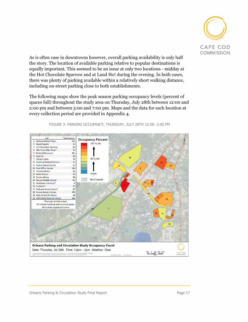
As is often case in downtowns however, overall parking availability is only half
the story. The location of available parking relative to popular destinations is
equally important. This seemed to be an issue at only two locations - midday at
the Hot Chocolate Sparrow and at Land Ho! during the evening. In both cases,
there was plenty of parking available within a relatively short walking distance,
including on-street parking close to both establishments.
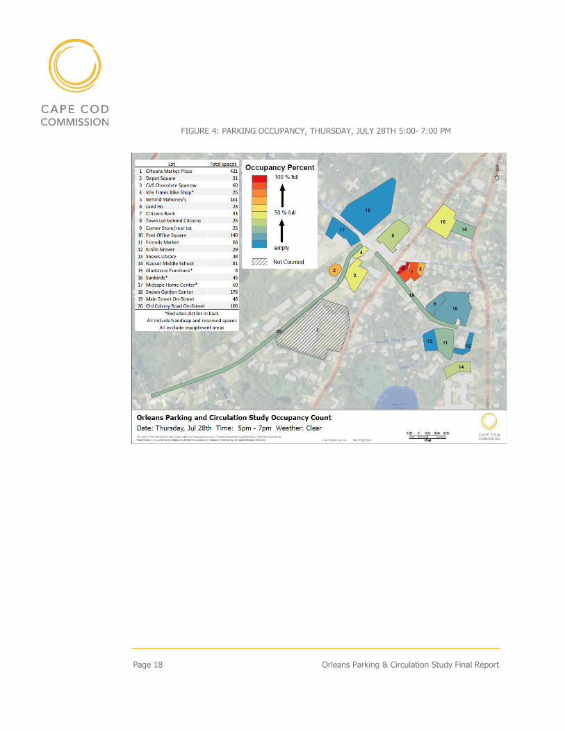
The following maps show the peak season parking occupancy levels (percent of
spaces full) throughout the study area on Thursday, July 28th between 12:00 and
2:00 pm and between 5:00 and 7:00 pm. Maps and the data for each location at
every collection period are provided in Appendix 4.
FIGURE 3: PARKING OCCUPANCY, THURSDAY, JULY 28TH 12:00- 2:00 PM
Page 18 Orleans Parking & Circulation Study Final Report
FIGURE 4: PARKING OCCUPANCY, THURSDAY, JULY 28TH 5:00- 7:00 PM
Orleans Parking & Circulation Study Final Report Page 19
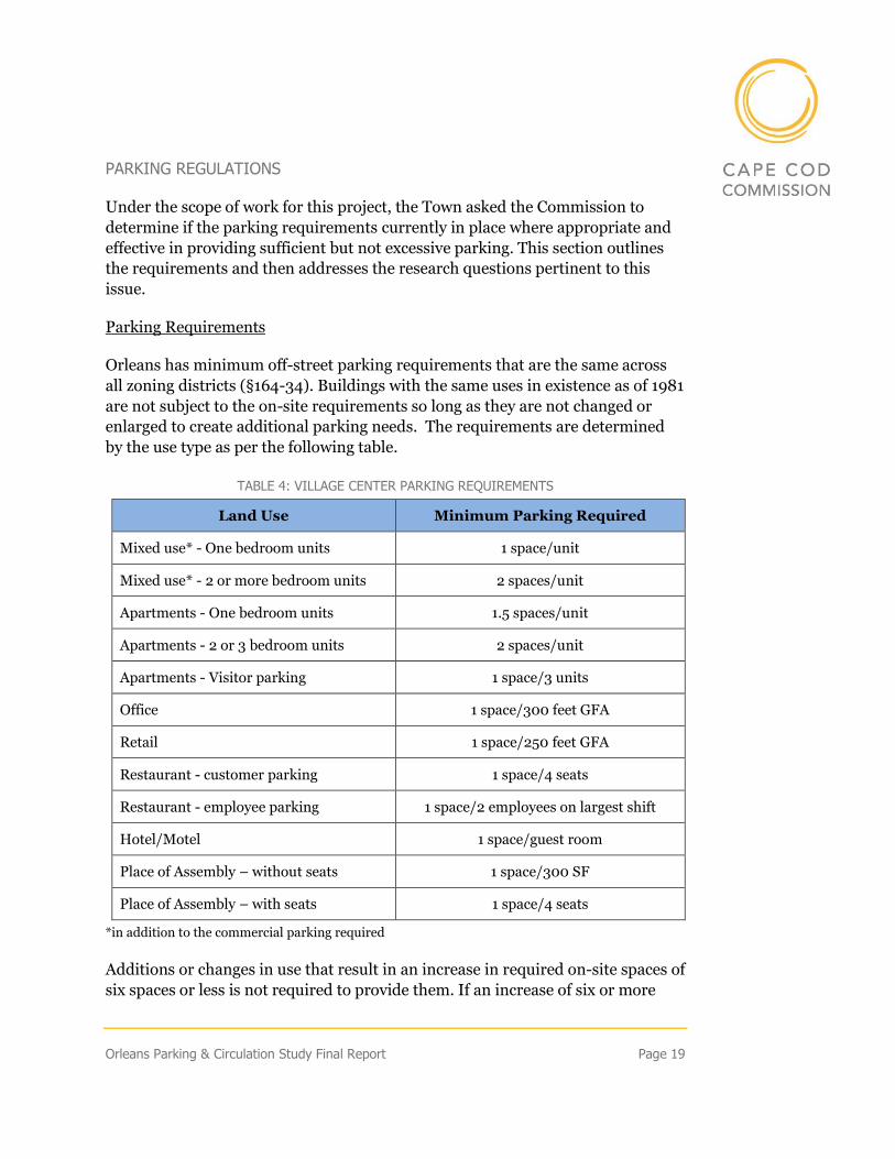
PARKING REGULATIONS
Under the scope of work for this project, the Town asked the Commission to
determine if the parking requirements currently in place where appropriate and
effective in providing sufficient but not excessive parking. This section outlines
the requirements and then addresses the research questions pertinent to this
issue.
Parking Requirements
Orleans has minimum off-street parking requirements that are the same across
all zoning districts (§164-34). Buildings with the same uses in existence as of 1981
are not subject to the on-site requirements so long as they are not changed or
enlarged to create additional parking needs. The requirements are determined
by the use type as per the following table.
TABLE 4: VILLAGE CENTER PARKING REQUIREMENTS
Land Use Minimum Parking Required
Mixed use* - One bedroom units 1 space/unit
Mixed use* - 2 or more bedroom units 2 spaces/unit
Apartments - One bedroom units 1.5 spaces/unit
Apartments - 2 or 3 bedroom units 2 spaces/unit
Apartments - Visitor parking 1 space/3 units
Office 1 space/300 feet GFA
Retail 1 space/250 feet GFA
Restaurant - customer parking 1 space/4 seats
Restaurant - employee parking 1 space/2 employees on largest shift
Hotel/Motel 1 space/guest room
Place of Assembly – without seats 1 space/300 SF
Place of Assembly – with seats 1 space/4 seats
*in addition to the commercial parking required
Additions or changes in use that result in an increase in required on-site spaces of
six spaces or less is not required to provide them. If an increase of six or more
Page 20 Orleans Parking & Circulation Study Final Report
spaces is needed, all of the spaces must be provided. Special permit authorization
is required to obtain a reduction in the required number of spaces.
Location of on-site Parking
On-site parking is currently permitted in front of, behind, and to the side of the
building. It is permitted in the setbacks except for the side setbacks. There is no
requirement that the parking be setback from the building, but it must be 10 feet
from the roadway. Off-site parking is permitted but must be within 500 feet of
the building or lot line.
Alternatives for Meeting on-site Parking Requirements
The zoning bylaw provides for two alternative means of meeting the on-site
parking requirements:
1. Shared on-site Parking
2. “Fee in-lieu of” on-site Parking
The shared parking provision allows adjacent businesses to share parking spaces;
it does not, however, automatically allow for a reduction in the number of spaces
required. The minimum number required must equal the combined minimum
requirement for each business based on their use. While, requiring the minimum
for each use ensures an adequate supply of parking, this may not provide
sufficient incentive for developers to opt for shared parking. Recent zoning
change do allow the building inspector to grant a 20% reduction for shared
parking (previously only the ZBA could grant reductions through special permit)
where it is shown that shared parking will still meet the needs of different users
without conflict.
The “fee in lieu of” provision (Section §164-34 A (4)) allows an applicant/use in
the Village Center zoning district to satisfy all or part of the required on-site
parking by paying an annual access fee ($500, indexed to the US Cost of Living
Index) per space as an option to meeting the minimum on-site requirement. This
option is only available if the town has appropriated and authorized buying or
creating off-street parking and the cost of that is greater than the amount to be
collected in lieu of parking. Municipal finance laws limit the circumstances in
which receipts may be dedicated for special accounts. In lieu fee options provide
flexibility for developers to meet on-site parking requirements and provide a
financing mechanism for a town construct public parking.
Orleans Parking & Circulation Study Final Report Page 21
Research Question: How many businesses have the amount of parking
required by the zoning by-law? How many depend entirely on public parking?
An overall analysis conducted by the Town of parking in the Village Center
indicates that a clear majority (78%) of properties within the Village Center
provide excess parking above that required in zoning or meet the zoning
requirements. Only twenty-two properties do not provide the required parking on
the same lot – most of these are historic properties that reflect the community
character and building design desired by the Town as articulated in the LCP.
FIGURE 5: VILLAGE CENTER PARKING SPACES RELATIVE TO REQUIRED IN ZONING
Page 22 Orleans Parking & Circulation Study Final Report
Research Question: Does the zoning by-law require more parking than
necessary? Are the incentives for shared parking and in-lieu of parking
payments sufficient? Are there alternative best practices that should be
considered in revising the parking regulations?
The current parking requirements, had they been in place when the existing
development was built, would have increased parking by 41% adding over 600
more parking spaces that exist today.
Given that current parking is seldom used to capacity, the zoning does seem to
require more parking than is necessary in aggregate. Furthermore, as shown
above, many sites exceed current parking requirements. Many communities
faced with this situation have changed minimum parking requirements to
maximum parking limits.
TABLE 5: VILLAGE CENTER ESTIMATED PARKING UNDER ZONING
Minimum Parking Estimate in Village Center Zoning District
Land Use Units/SF Units
Minimum Req.
Spaces by Use
Est. total Min.
Parking Required
Number of Existing Residential Units: 55
SF Homes 7 homes 2 14
Apartments 7 units 2.33 16
Mixed Use Residential Units 41 units 2 82
Total SF of Existing Commercial Uses: 477,489
Retail 412,028 SF .004 1,648
Restaurant - Customers* 668 seats .25 167
Restaurant – Employees** 91 staff .5 46
Office/Bank 33,424 SF .00333 111
Lodging*** 43 rooms 1 43
Places of Assembly 37,605 SF .00333 125
Orleans Parking & Circulation Study Final Report Page 23
Minimum Parking Estimate in Village Center Zoning District
Land Use Units/SF Units
Minimum Req.
Spaces by Use
Est. total Min.
Parking Required
Total estimate of parking required by zoning for existing uses 2,252
Existing parking (in inventory) 1,596
Source: AECOM Build-out Data * Total SF = 16,712; dining room is 60% of total SF; 15 SF per person = estimated 668 seats; **Employees estimate based on four-tops with one waitperson per 3 tables = 56 waiters plus 35 kitchen and other staff for a total of 91 per shift maximum ***Total SF = 14,325; used Average room size = 325 SF to determine rooms
It is somewhat difficult to assess the effectiveness of incentives for businesses to
share parking given the low turnover of properties in the study area. There are a
number of lots that are effectively shared and have been for years; these include
the two busiest parking areas – the CVS/Chocolate Sparrow lot during the day
and, in the evening, the public lot off Cove Road with the lots behind the bank
and Land Ho!.
SUMMARY - PARKING
The Orleans Village Center has enough parking to accommodate current levels
of business activity throughout the day and evening. Only two lots reach
capacity during the summer peak - the parking lot behind the Hot Chocolate
Sparrow/CVS during the day and, in the evenings, the lots behind Land Ho!
While most parking is in private hands, it often functions like public parking,
serving multiple businesses and allowing people to walk between stores rather
than drive. Should the village get busier however, the owners of these parking
areas may seek to restrict this informal sharing. This could negatively impact
parking availability, congestion, and walkability.
Data suggests that zoning requirements may be excessive and there is already
more parking on some properties than necessary.
Page 24 Orleans Parking & Circulation Study Final Report
CIRCULATION ASSESSMENT
Research Question: How well are intersections in the Village Center working
for cars, bikes, and pedestrians in terms of safety and time delay at
intersections (level of service)? How do they perform at different times of day in
both the spring and summer?
Commission staff compiled existing traffic volume data and crash data for all
major roadways and intersection within the study area. To supplement the
available data, staff collected the following data, primarily during the last week of
July 2016:
• 12 Roadway counts (24 hours per day – 6 days in duration)
• 5 Intersection peak period counts (4-5:30 PM)
• 12-Hour Cape Cod Rail Trail count (7/5/16 – 861 non-motorist)
SAFETY
Crash data was compiled from the Massachusetts Registry of Motor records for
the most recent five years on record, 2010-2014. This data includes all crashes
reported on roadways within the study area. It should be noted that only crashes
that result in death, injury, or damage that exceeds $1,000 are required to be
reported. Additional, unreported crashes likely occurred within the study area
that cannot be tracked. Often crashes involving a pedestrian or bicyclist when
injuries do not require hospitalization are not reported.
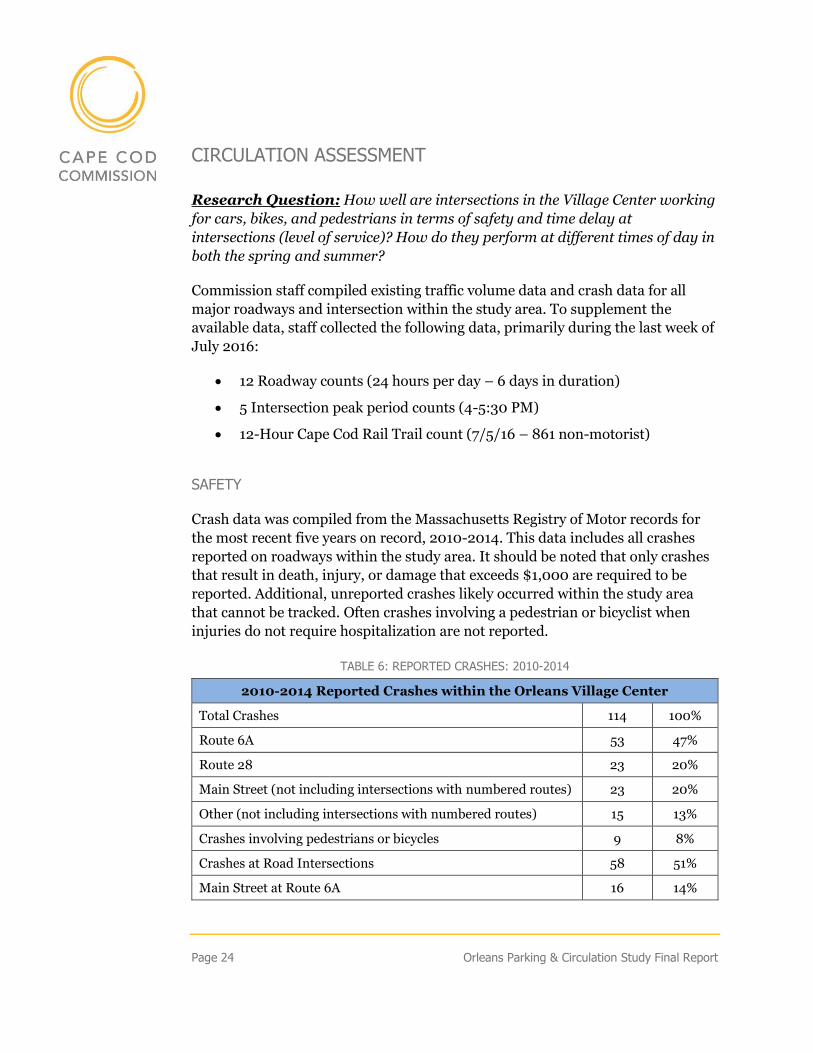
TABLE 6: REPORTED CRASHES: 2010-2014
2010-2014 Reported Crashes within the Orleans Village Center
Total Crashes 114 100%
Route 6A 53 47%
Route 28 23 20%
Main Street (not including intersections with numbered routes) 23 20%
Other (not including intersections with numbered routes) 15 13%
Crashes involving pedestrians or bicycles 9 8%
Crashes at Road Intersections 58 51%
Main Street at Route 6A 16 14%
Orleans Parking & Circulation Study Final Report Page 25
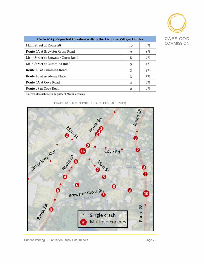
2010-2014 Reported Crashes within the Orleans Village Center
Main Street at Route 28 10 9%
Route 6A at Brewster Cross Road 9 8%
Main Street at Brewster Cross Road 8 7%
Main Street at Cummins Road 5 4%
Route 28 at Cummins Road 3 3%
Route 28 at Academy Place 3 3%
Route 6A at Cove Road 2 2%
Route 28 at Cove Road 2 2%
Source: Massachusetts Registry of Motor Vehicles
FIGURE 6: TOTAL NUMBER OF CRASHES (2010-2014)
Page 26 Orleans Parking & Circulation Study Final Report
As shown in the next figure, the two locations with the highest number of vehicle
crashes are the intersection of Route 6A at Main Street and Route 28 at Main
Street. Both intersections are currently being rebuilt by the Massachusetts
Department of Transportation, in part, to address some safety deficiencies with
the current designs. Both ends of Brewster Cross Road have also been the site of
numerous reported accidents, more accidents have occurred at these locations
combined than at the intersection of Route 6A and Main Street.
The rest of the crashes in the area are clustered at various intersection and
driveways throughout the study area. This crash pattern is similar to other
downtown areas on Cape Cod. Strategies to reduce these types of crashes include
improved driveway design and improved access management, particularly
reducing the size and number of curbs cut where possible.
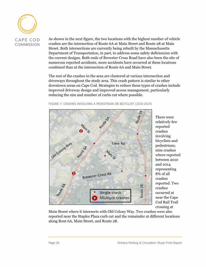
FIGURE 7: CRASHES INVOLVING A PEDESTRIAN OR BICYCLIST (2010-2014)
There were
relatively few
reported
crashes
involving
bicyclists and
pedestrians;
nine crashes
where reported
between 2010
and 2014
representing
8% of all
crashes
reported. Two
crashes
occurred at
near the Cape
Cod Rail Trail
crossing at
Main Street where it intersects with Old Colony Way. Two crashes were also
reported near the Staples Plaza curb cut and the remainder at different locations
along Rout 6A, Main Street, and Route 28.
Orleans Parking & Circulation Study Final Report Page 27
TRAFFIC VOLUMES
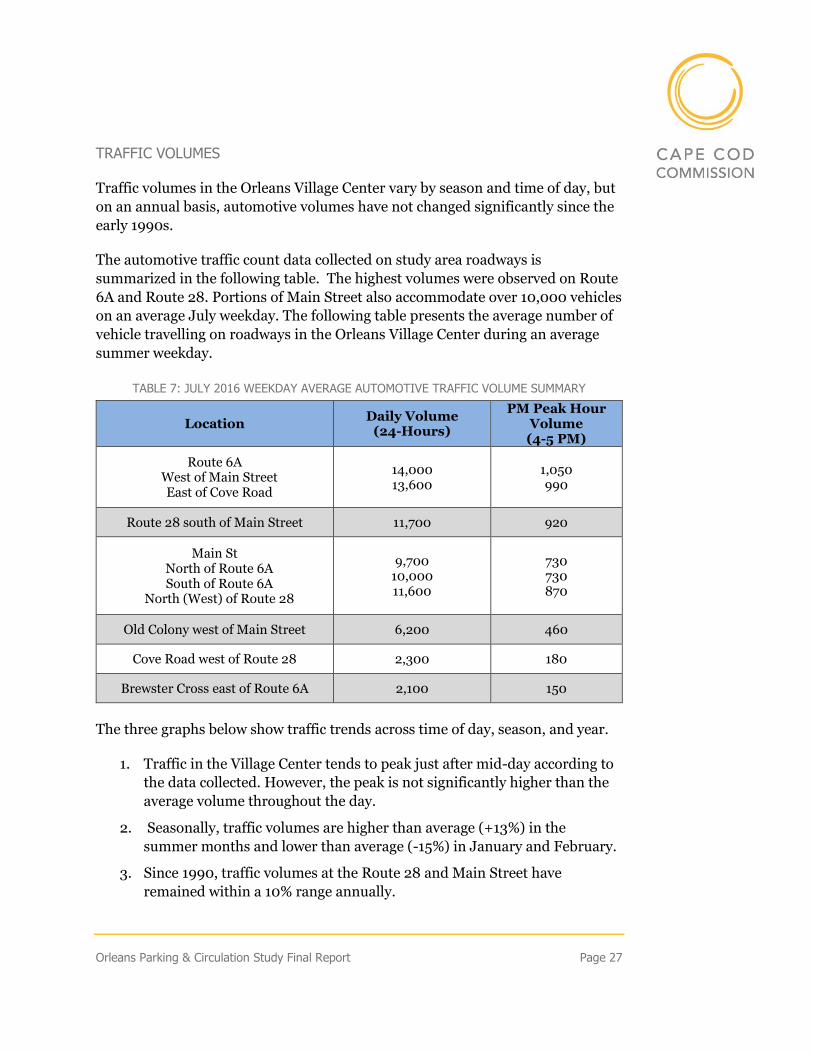
Traffic volumes in the Orleans Village Center vary by season and time of day, but
on an annual basis, automotive volumes have not changed significantly since the
early 1990s.
The automotive traffic count data collected on study area roadways is
summarized in the following table. The highest volumes were observed on Route
6A and Route 28. Portions of Main Street also accommodate over 10,000 vehicles
on an average July weekday. The following table presents the average number of
vehicle travelling on roadways in the Orleans Village Center during an average
summer weekday.
TABLE 7: JULY 2016 WEEKDAY AVERAGE AUTOMOTIVE TRAFFIC VOLUME SUMMARY
Location Daily Volume
(24-Hours)
PM Peak Hour Volume (4-5 PM)
Route 6A West of Main Street East of Cove Road
14,000 13,600
1,050 990
Route 28 south of Main Street 11,700 920
Main St North of Route 6A South of Route 6A
North (West) of Route 28
9,700 10,000 11,600
730 730 870
Old Colony west of Main Street 6,200 460
Cove Road west of Route 28 2,300 180
Brewster Cross east of Route 6A 2,100 150
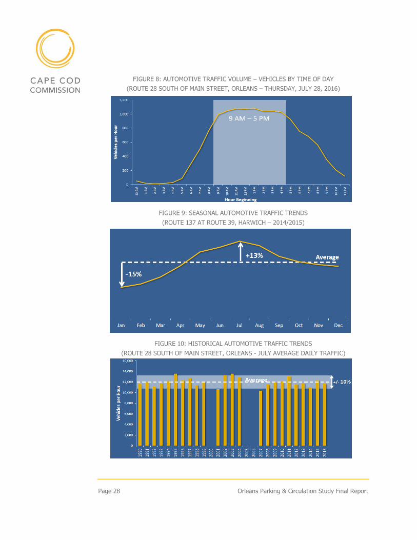
The three graphs below show traffic trends across time of day, season, and year.
1. Traffic in the Village Center tends to peak just after mid-day according to
the data collected. However, the peak is not significantly higher than the
average volume throughout the day.
2. Seasonally, traffic volumes are higher than average (+13%) in the
summer months and lower than average (-15%) in January and February.
3. Since 1990, traffic volumes at the Route 28 and Main Street have
remained within a 10% range annually.
Page 28 Orleans Parking & Circulation Study Final Report
FIGURE 8: AUTOMOTIVE TRAFFIC VOLUME – VEHICLES BY TIME OF DAY
(ROUTE 28 SOUTH OF MAIN STREET, ORLEANS – THURSDAY, JULY 28, 2016)
FIGURE 9: SEASONAL AUTOMOTIVE TRAFFIC TRENDS
(ROUTE 137 AT ROUTE 39, HARWICH – 2014/2015)
FIGURE 10: HISTORICAL AUTOMOTIVE TRAFFIC TRENDS
(ROUTE 28 SOUTH OF MAIN STREET, ORLEANS - JULY AVERAGE DAILY TRAFFIC)
Orleans Parking & Circulation Study Final Report Page 29
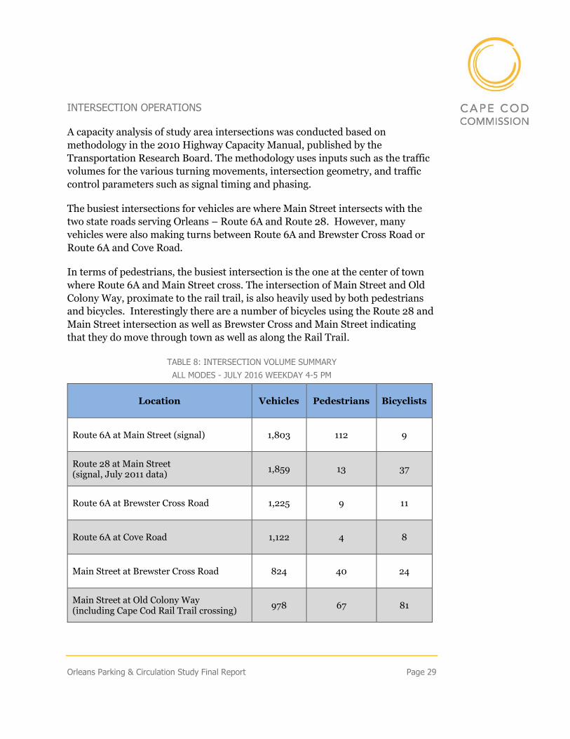
INTERSECTION OPERATIONS
A capacity analysis of study area intersections was conducted based on
methodology in the 2010 Highway Capacity Manual, published by the
Transportation Research Board. The methodology uses inputs such as the traffic
volumes for the various turning movements, intersection geometry, and traffic
control parameters such as signal timing and phasing.
The busiest intersections for vehicles are where Main Street intersects with the
two state roads serving Orleans – Route 6A and Route 28. However, many
vehicles were also making turns between Route 6A and Brewster Cross Road or
Route 6A and Cove Road.
In terms of pedestrians, the busiest intersection is the one at the center of town
where Route 6A and Main Street cross. The intersection of Main Street and Old
Colony Way, proximate to the rail trail, is also heavily used by both pedestrians
and bicycles. Interestingly there are a number of bicycles using the Route 28 and
Main Street intersection as well as Brewster Cross and Main Street indicating
that they do move through town as well as along the Rail Trail.
TABLE 8: INTERSECTION VOLUME SUMMARY
ALL MODES - JULY 2016 WEEKDAY 4-5 PM
Location Vehicles Pedestrians Bicyclists
Route 6A at Main Street (signal) 1,803 112 9
Route 28 at Main Street (signal, July 2011 data)
1,859 13 37
Route 6A at Brewster Cross Road 1,225 9 11
Route 6A at Cove Road 1,122 4 8
Main Street at Brewster Cross Road 824 40 24
Main Street at Old Colony Way (including Cape Cod Rail Trail crossing)
978 67 81
Page 30 Orleans Parking & Circulation Study Final Report
The vehicle capacity analysis reports average delay, in seconds, and level of
service (LOS). LOS is presented as a letter-grade, from A to F, based on average
vehicle delay. The grade of A represents uncongested conditions with very little
delay. LOS C or D indicates that the intersection is busy but still considered
acceptable. LOS E or F indicates that an intersection is congested, and delays may
be considered long. However, in downtown areas, it is not uncommon for
intersections to operate to LOS E or F and still be both well-functioning and safe.
Efficient vehicle accommodation must be balanced with safe and convenient
accommodation of pedestrians and bicyclists.
The following tables provide the vehicle the LOS grades for the major
intersections within the study area as well as the level of pedestrian
accommodation; first for intersections with traffic signals and then for those
without signals.
TABLE 9: EXISTING CONDITIONS
SIGNALIZED INTERSECTION CAPACITY ANALYSIS - JULY EVENING PEAK HOUR
2017 Existing Conditions
Location Level of Service1
Delay2 Pedestrian/Bicyclist Accommodation
Route 6A at Main Street C 27.9 Crosswalks with push button-
activated pedestrian signal
Route 28 at Main Street C 31.7 Crosswalks with push button-
activated pedestrian signal
1 Based on 2010 Highway Capacity Manual methodology 2 Average delay in seconds per vehicle; based on 2010 Highway Capacity Manual methodology
TABLE 10: EXISTING CONDITIONS
UN-SIGNALIZED INTERSECTION CAPACITY ANALYSIS - JULY EVENING PEAK HOUR
2017 Existing Conditions
Location Level of Service1 Delay2 Pedestrian/Bicyclist
Accommodation
Route 6A at Brewster Cross Road
Route 6A Eastbound
A 8.8
None Route 6A Westbound
A 9.0
Brewster Cross Road Northbound3
C 22.6
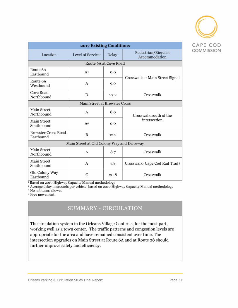
Orleans Parking & Circulation Study Final Report Page 31
2017 Existing Conditions
Location Level of Service1 Delay2 Pedestrian/Bicyclist
Accommodation
Route 6A at Cove Road
Route 6A Eastbound
A4 0.0
Crosswalk at Main Street Signal Route 6A Westbound
A 9.0
Cove Road Northbound
D 27.2 Crosswalk
Main Street at Brewster Cross
Main Street Northbound
A 8.0 Crosswalk south of the
intersection Main Street Southbound
A4 0.0
Brewster Cross Road Eastbound
B 12.2 Crosswalk
Main Street at Old Colony Way and Driveway
Main Street Northbound
A 8.7 Crosswalk
Main Street Southbound
A 7.8 Crosswalk (Cape Cod Rail Trail)
Old Colony Way Eastbound
C 20.8 Crosswalk
1 Based on 2010 Highway Capacity Manual methodology 2 Average delay in seconds per vehicle; based on 2010 Highway Capacity Manual methodology 3 No left turns allowed 4 Free movement
SUMMARY - CIRCULATION
The circulation system in the Orleans Village Center is, for the most part,
working well as a town center. The traffic patterns and congestion levels are
appropriate for the area and have remained consistent over time. The
intersection upgrades on Main Street at Route 6A and at Route 28 should
further improve safety and efficiency.
Page 32 Orleans Parking & Circulation Study Final Report
Growth Impact Assessment
Research Question: How will future development affect parking demand and
intersection performance in the Village Center?
Zoning amendments alone do not create transportation impacts. As the zoning
amendment increased the potential for residential development, it is important
to understand the relative impact of residential development compared to other
potential types of development.
Residential uses are some of the lowest traffic generators, having significantly
less impact on traffic than most commercial uses. For example, the trips
generated by a 5,000 square-foot building vary by use:
TABLE 11: TRIPS GENERATED BY 5,000 SF BY USE
Use Expected Trip Generation (trips/day)
Retail 200
Restaurant 600
Residential 25
The nature and scale of the impacts will ultimately depend on how much
additional development occurs as a result of the zoning change.
To analyze potential transportation impacts, zoning provisions must be tested
based on a consistent set of assumptions. The assumptions used here are:
1. Scenarios will estimate traffic volumes 20 years from today
2. Underlying traffic volumes will increase 1% percent per year
The 1% annual growth a conservative (high) assumption based on historic traffic
volume trends. This one percent annual traffic growth assumption would cover
the typical development activity the Town has seen under existing zoning and
well as the impact of development in nearby towns.
For this analysis, three different scenarios were considered and compared to
existing conditions.
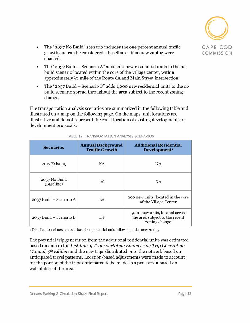
Orleans Parking & Circulation Study Final Report Page 33
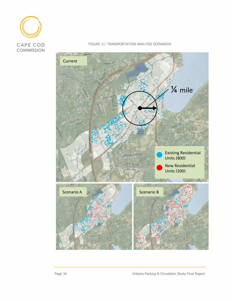
• The “2037 No Build” scenario includes the one percent annual traffic
growth and can be considered a baseline as if no new zoning were
enacted.
• The “2037 Build – Scenario A” adds 200 new residential units to the no
build scenario located within the core of the Village center, within
approximately ½ mile of the Route 6A and Main Street intersection.
• The “2037 Build – Scenario B” adds 1,000 new residential units to the no
build scenario spread throughout the area subject to the recent zoning
change.
The transportation analysis scenarios are summarized in the following table and
illustrated on a map on the following page. On the maps, unit locations are
illustrative and do not represent the exact location of existing developments or
development proposals.
TABLE 12: TRANSPORTATION ANALYSIS SCENARIOS
Scenarios Annual Background
Traffic Growth Additional Residential
Development1
2017 Existing NA NA
2037 No Build (Baseline)
1% NA
2037 Build – Scenario A 1% 200 new units, located in the core
of the Village Center
2037 Build – Scenario B 1% 1,000 new units, located across
the area subject to the recent zoning change
1 Distribution of new units is based on potential units allowed under new zoning
The potential trip generation from the additional residential units was estimated
based on data in the Institute of Transportation Engineering Trip Generation
Manual, 9th Edition and the new trips distributed onto the network based on
anticipated travel patterns. Location-based adjustments were made to account
for the portion of the trips anticipated to be made as a pedestrian based on
walkability of the area.
Page 34 Orleans Parking & Circulation Study Final Report
FIGURE 11: TRANSPORTATION ANALYSIS SCENARIOS
Scenario A Scenario B
Existing Residential Units (800)
New Residential Units (200)
Current
Orleans Parking & Circulation Study Final Report Page 35
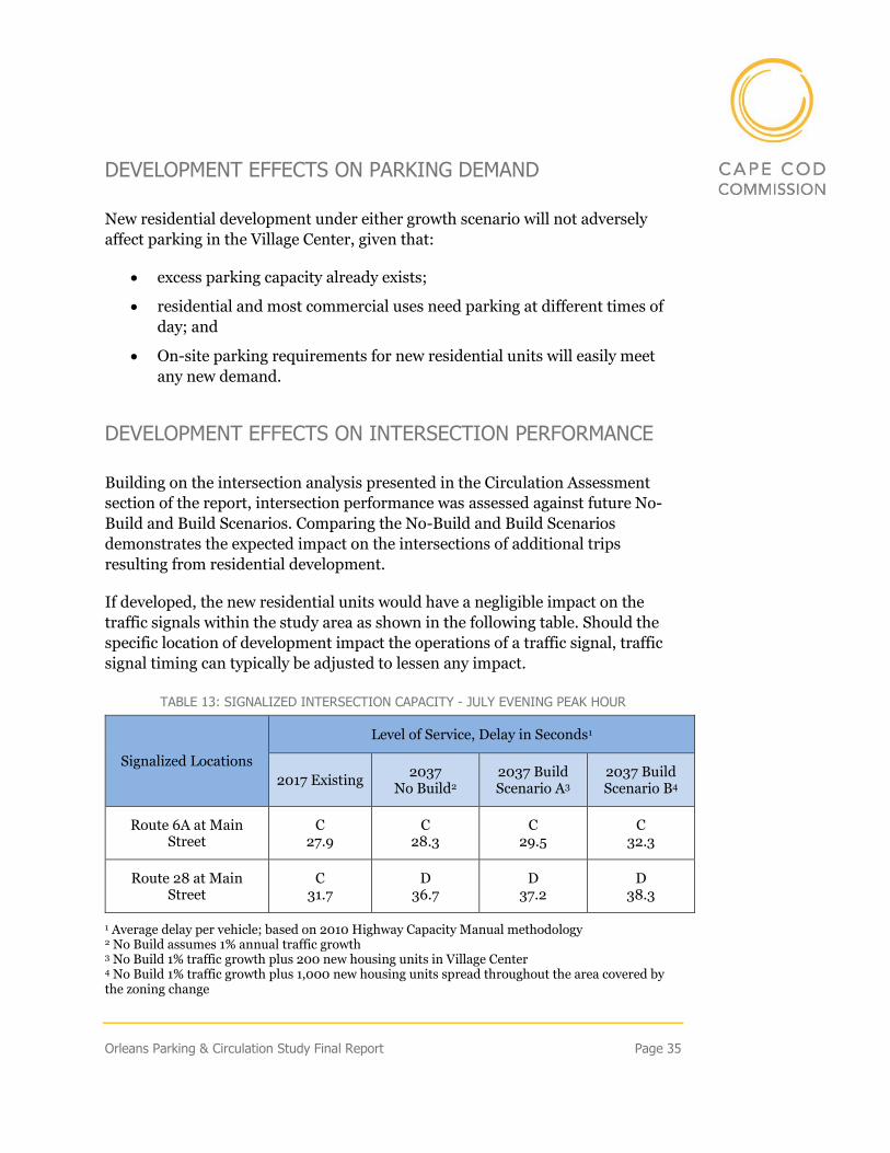
DEVELOPMENT EFFECTS ON PARKING DEMAND
New residential development under either growth scenario will not adversely
affect parking in the Village Center, given that:
• excess parking capacity already exists;
• residential and most commercial uses need parking at different times of
day; and
• On-site parking requirements for new residential units will easily meet
any new demand.
DEVELOPMENT EFFECTS ON INTERSECTION PERFORMANCE
Building on the intersection analysis presented in the Circulation Assessment
section of the report, intersection performance was assessed against future No-
Build and Build Scenarios. Comparing the No-Build and Build Scenarios
demonstrates the expected impact on the intersections of additional trips
resulting from residential development.
If developed, the new residential units would have a negligible impact on the
traffic signals within the study area as shown in the following table. Should the
specific location of development impact the operations of a traffic signal, traffic
signal timing can typically be adjusted to lessen any impact.
TABLE 13: SIGNALIZED INTERSECTION CAPACITY - JULY EVENING PEAK HOUR
Signalized Locations
Level of Service, Delay in Seconds1
2017 Existing 2037
No Build2 2037 Build Scenario A3
2037 Build Scenario B4
Route 6A at Main Street
C 27.9
C 28.3
C 29.5
C 32.3
Route 28 at Main Street
C 31.7
D 36.7
D 37.2
D 38.3
1 Average delay per vehicle; based on 2010 Highway Capacity Manual methodology 2 No Build assumes 1% annual traffic growth 3 No Build 1% traffic growth plus 200 new housing units in Village Center 4 No Build 1% traffic growth plus 1,000 new housing units spread throughout the area covered by the zoning change
Page 36 Orleans Parking & Circulation Study Final Report
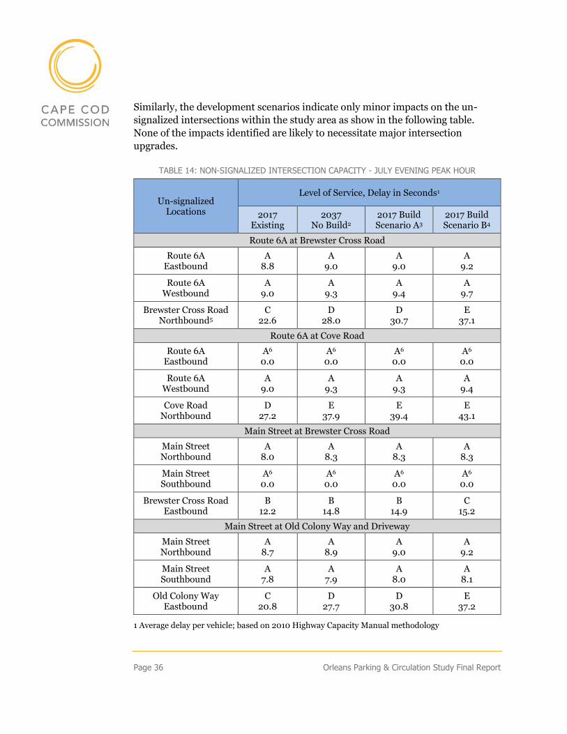
Similarly, the development scenarios indicate only minor impacts on the un-
signalized intersections within the study area as show in the following table.
None of the impacts identified are likely to necessitate major intersection
upgrades.
TABLE 14: NON-SIGNALIZED INTERSECTION CAPACITY - JULY EVENING PEAK HOUR
Un-signalized Locations
Level of Service, Delay in Seconds1
2017 Existing
2037 No Build2
2017 Build Scenario A3
2017 Build Scenario B4
Route 6A at Brewster Cross Road
Route 6A Eastbound
A 8.8
A 9.0
A 9.0
A 9.2
Route 6A Westbound
A 9.0
A 9.3
A 9.4
A 9.7
Brewster Cross Road Northbound5
C 22.6
D 28.0
D 30.7
E 37.1
Route 6A at Cove Road
Route 6A Eastbound
A6 0.0
A6 0.0
A6 0.0
A6 0.0
Route 6A Westbound
A 9.0
A 9.3
A 9.3
A 9.4
Cove Road Northbound
D 27.2
E 37.9
E 39.4
E 43.1
Main Street at Brewster Cross Road
Main Street Northbound
A 8.0
A 8.3
A 8.3
A 8.3
Main Street Southbound
A6 0.0
A6 0.0
A6 0.0
A6 0.0
Brewster Cross Road Eastbound
B 12.2
B 14.8
B 14.9
C 15.2
Main Street at Old Colony Way and Driveway
Main Street Northbound
A 8.7
A 8.9
A 9.0
A 9.2
Main Street Southbound
A 7.8
A 7.9
A 8.0
A 8.1
Old Colony Way Eastbound
C 20.8
D 27.7
D 30.8
E 37.2
1 Average delay per vehicle; based on 2010 Highway Capacity Manual methodology
Orleans Parking & Circulation Study Final Report Page 37
2 No Build assumes 1% annual traffic growth 3 No Build 1% traffic growth plus 200 new housing units in Village Center 4 No Build 1% traffic growth plus 1,000 new housing units spread throughout the area covered by the zoning change 5 No left turns allowed 6 Free movement
Finally, the simulation shows negligible intersection delay increases on Route 6A
and Main Street approaches as a result of increased residential development.
Drivers approaching the center from the minor streets may face a slight increase
in delays when turning left or going straight. These delays will likely be less than
what is reported in the tables as estimates of delay at un-signalized intersections,
as these tend to be conservatively high. Overall, both signalized and un-signalized
intersections are anticipated to continue functioning well even with additional
residential trips as a result of housing units being added to the village core.
Nevertheless, depending on location and size, large residential developments
could cause larger localized impacts. Such impacts would have to be address
during the review of such a development. The impacts of such developments can
be minimized by:
• Minimizing curb cuts;
• Good driveway and site design (small block);
• Shared parking and infrastructure; and
• Safe and convenient pedestrian, bicyclist, and transit user
accommodation.
SUMMARY – FUTURE IMPACTS
In terms of transportation infrastructure, the Village Center is well
positioned to handle additional residential development.
Both signalized intersections currently operate at an acceptable level of
service and, with the upgrades underway, the signals will be up to current
design standards and capable of handling additional traffic from the
potential residential development. Localized impacts may be noticed very
close to new developments of substantial scale, but, overall, the
transportation network should continue to function well.
Page 38 Orleans Parking & Circulation Study Final Report
Summary of Findings & Next Steps
SUMMARY OF FINDINGS
The parking and circulation system in downtown Orleans is functioning
effectively and can accommodate further growth, particularly residential growth
in the village core. The system experiences intermittent congestion and full
parking lots at peak summer season but there are no systemic impediments to
circulation, parking, and related economic and social activity in the village center.
There is no need to add additional parking but use of existing lots could be
improved with better signage, layout, and pedestrian connections to store fronts.
Opportunities exist for cooperative management of parking lots and the
introduction of low impact design (LID) storm water management infrastructure.
The circulation system, with the improvements underway and those under
consideration for Brewster Cross, will improve safety and move traffic more
efficiently despite seasonal congestion. The system could be further improved by
breaking up large blocks with internal roads and alleys, adding signage for cars
and pedestrians, and adding safety provisions for cyclists and pedestrians.
With these tweaks, the system can easily manage increased residential
development, even and probably especially if the housing is highly concentrated
in the village core. A re-distribution of existing commercial activity into the core
would benefit the overall vibrancy of the center as well, recognizing that new
commercial space is not currently called for according to local and regional
market studies. Any near-term growth or shifts should be accommodated with
better provisions for non-auto movement within the village center.
RECOMMENDED NEXT STEPS
The following is a limited set of recommended next steps that, given the data,
staff feels will have the most immediate or significant impact on an already well-
functioning parking and circulation system in the Village Center. Many of them
mirror recommendations found in previous studies that have not yet been
implemented. Where possible, conceptual plans and conceptual planning maps
have been included.
Orleans Parking & Circulation Study Final Report Page 39
PARKING
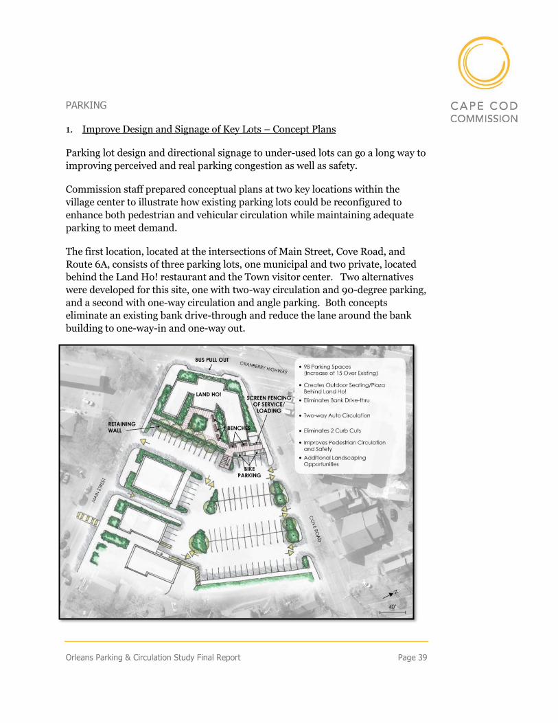
1. Improve Design and Signage of Key Lots – Concept Plans
Parking lot design and directional signage to under-used lots can go a long way to
improving perceived and real parking congestion as well as safety.
Commission staff prepared conceptual plans at two key locations within the
village center to illustrate how existing parking lots could be reconfigured to
enhance both pedestrian and vehicular circulation while maintaining adequate
parking to meet demand.
The first location, located at the intersections of Main Street, Cove Road, and
Route 6A, consists of three parking lots, one municipal and two private, located
behind the Land Ho! restaurant and the Town visitor center. Two alternatives
were developed for this site, one with two-way circulation and 90-degree parking,
and a second with one-way circulation and angle parking. Both concepts
eliminate an existing bank drive-through and reduce the lane around the bank
building to one-way-in and one-way out.
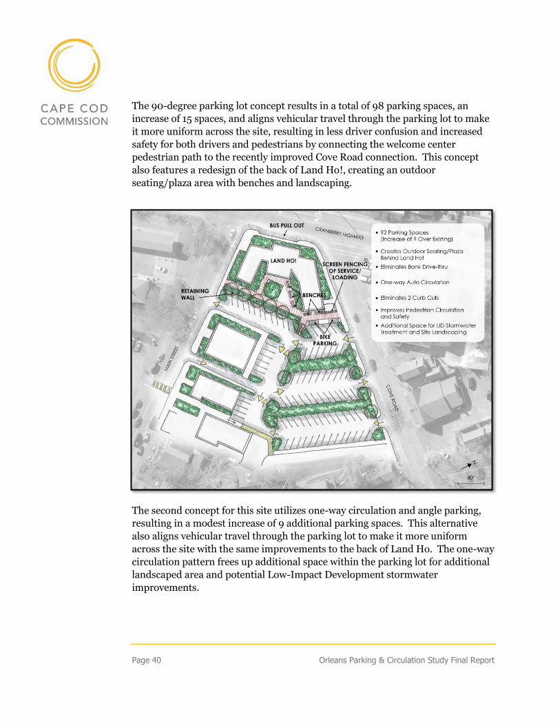
Page 40 Orleans Parking & Circulation Study Final Report
The 90-degree parking lot concept results in a total of 98 parking spaces, an
increase of 15 spaces, and aligns vehicular travel through the parking lot to make
it more uniform across the site, resulting in less driver confusion and increased
safety for both drivers and pedestrians by connecting the welcome center
pedestrian path to the recently improved Cove Road connection. This concept
also features a redesign of the back of Land Ho!, creating an outdoor
seating/plaza area with benches and landscaping.
The second concept for this site utilizes one-way circulation and angle parking,
resulting in a modest increase of 9 additional parking spaces. This alternative
also aligns vehicular travel through the parking lot to make it more uniform
across the site with the same improvements to the back of Land Ho. The one-way
circulation pattern frees up additional space within the parking lot for additional
landscaped area and potential Low-Impact Development stormwater
improvements.
Orleans Parking & Circulation Study Final Report Page 41
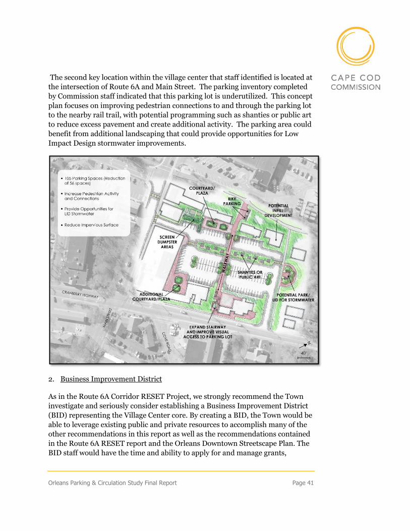
The second key location within the village center that staff identified is located at
the intersection of Route 6A and Main Street. The parking inventory completed
by Commission staff indicated that this parking lot is underutilized. This concept
plan focuses on improving pedestrian connections to and through the parking lot
to the nearby rail trail, with potential programming such as shanties or public art
to reduce excess pavement and create additional activity. The parking area could
benefit from additional landscaping that could provide opportunities for Low
Impact Design stormwater improvements.
2. Business Improvement District
As in the Route 6A Corridor RESET Project, we strongly recommend the Town
investigate and seriously consider establishing a Business Improvement District
(BID) representing the Village Center core. By creating a BID, the Town would be
able to leverage existing public and private resources to accomplish many of the
other recommendations in this report as well as the recommendations contained
in the Route 6A RESET report and the Orleans Downtown Streetscape Plan. The
BID staff would have the time and ability to apply for and manage grants,
Page 42 Orleans Parking & Circulation Study Final Report
coordinate Village events, garner volunteer support, and meet regularly with
businesses. The BID would support, at a minimum, an Executive Director
dedicated to creating a vibrant center with the active support of businesses in the
Village Center.
A Business Improvement District is special taxing district enabled through state
legislation (MGL 40O) and organized as a not-for-profit corporation to
supplement municipal services in a commercial district. They serve a defined
area in which businesses agree to pay an annual special assessment to fund the
organization and projects within the district’s boundaries.
To be approved, a BID must have the support of 60% of the real property owners
who represent 51% or more of the assessed real property valuation in the district
to be designated. Once approved, a BID organization may focus on a range of
activities including public safety, streetscape improvements, business assistance,
and/or public policy.
Because BID members pay this special assessment, the organization has an
ongoing, stable revenue stream for the District, unlike other redevelopment
entities in Massachusetts. In addition to this guaranteed revenue, a BID may
receive grants, donations, and gifts to support their initiatives if they are
incorporated as a 501C3 non-profit organization.
The Hyannis Main Street Business Improvement District was established in 1999
to promote and stimulate a renaissance of Main Street, Hyannis. The goal is to
promote community and economic development on Main Street, making the
Hyannis district as a desirable place to live, work, invest, and visit. The BID is a
501c6 non-profit organization serving the businesses and organizations fronting
Main Street.
The BID was established to improve the commercial appeal of downtown
Hyannis. Some of the accomplishments of the BID include bringing a police
station to Main Street, collaborating with homeless social programs, lobbying for
continued road improvements in the areas surrounding Main Street, and
leveraging funding for new street lights. The BID also created a WIFI network
along Main Street, improved the signs and banners along Main Street, and
oversees maintenance and beautification projects that include graffiti removal,
power-washing sidewalks, and providing supplemental trash and snow removal.
The BID works closely with local businesses and the Town to advocate for
continued improvement along Main Street, working with the Arts & Culture
District, launching a summer shuttle service, and supporting the Mid-Cape
Orleans Parking & Circulation Study Final Report Page 43
Farmers’ Market. The BID director meets with the Town Manager each month
and works closely with the leadership of the Hyannis Chamber, advocating for the
needs of main street businesses and coordinating specific events. The BID often
seeks funding for joint projects between the Town, Chamber, and others serving
the downtown.
Recent projects include working with the developer of a large housing project off
the east end of Main Street to shift the focus from seasonal to workforce housing.
In the same area of Main Street, the BID is working to obtain funding for
intersection improvements to create more of a gateway to Main Street and
encourage in-fill around the Regional Transportation Center.
3. Update parking regulations
Revising the parking requirements in the zoning code could provide for more
efficient and economical use of land and improve distribution of parking in the
Village Center, particularly as new development and redevelopment occurs. The
recommendations below are based in part on strategies provided in the state’s
Smart Growth/Smart Energy Toolkit produced by the Executive Office of
Environmental Affairs.1
Reduce Parking Requirements in the Village Center: Best practices for parking
management discourage using minimum parking standards, in part because they
often result in an over-supply of parking, encouraging inefficient use of land,
particularly in downtowns/village center areas, where density and high building
coverage is desired, and add to sprawl. Reducing existing parking requirements
is a critical step toward advancing “smart” land use practices.
Alternatives for the Town to consider include:
• Maximum Standards: The minimum requirements in most zoning bylaws
today are designed for the maximum amount of parking that a use could
ever need and create a vast oversupply of parking spaces. Best practices in
parking management promote adopting maximum parking standards
rather than minimum requirements. A simple method for Orleans to
1 http://www.mass.gov/envir/smart_growth_toolkit/pages/SG-bylaws.html. See Smart Parking Model Bylaw. The site also provides case studies.
Page 44 Orleans Parking & Circulation Study Final Report
establish maximum standards would be to change the existing minimum
requirements into maximum limits.
• Flexible Standards: The property/business owner determines the number
of spaces needed with the input of staff through the Site Plan Review
process
• No Parking Standards: Many towns and cities across the country have
eliminated parking standards without adverse consequences.
If the town is uncomfortable with eliminating minimum standards entirely, it
could provide both a maximum and minimum amount per use. This allows a
range of acceptable parking requirements and flexibility for a developer.
Depending on the use, the minimum requirement could be 25%-80% of the
maximum. For example, the state’s smart parking model bylaw suggests the
following requirements for office and retail (calculations are based on 1,000 sf
GFA)2:
Land Use Maximum Minimum
Retail 3 2
General Office 4 2
Encourage Shared Parking: The town could offer additional incentives for
developers to share parking, such as allowing greater building coverage or
flexibility in other dimensional standards in exchange for sharing parking. This
may be less important in a downtown area such as the Village Center, where the
scarcity and cost of land alone provides an economic incentive to share parking,
but could be very influential in other zoning districts.
To help encourage shared parking, the town might consider adding a new section
to the bylaw that sets forth guidance on shared parking and promotes it as a
preferred option. The current provision to allow parking reduction for “special
circumstances” is somewhat hidden in the by-law. The town might want to
promote shared parking by allowing a certain automatic reduction for uses on the
same or adjacent sites that have different peak hours of use, e.g. a bank and a
2 See Smart Growth/Smart Energy Toolkit produced by the Executive Office of Environmental Affairs. Smart Parking Model by available at: http://www.mass.gov/envir/smart_growth_toolkit/bylaws/SP-Bylaw.pdf
Orleans Parking & Circulation Study Final Report Page 45
restaurant, or an office and apartments. This could also benefit those who share
customers, e.g. a package store and a food market. During the review process, a
developer would be asked to demonstrate that the two uses have different peak
demands or that all parking needs can be met by the total on site. A contractual
agreement between the two businesses should be required as well.
Revise “Fee in lieu of” Provision: To make the fee in lieu an attractive option, it
must save money for the developer; however, the fee needs to be high enough for
the municipality to be able to use the funds to construct parking (or associated
amenities). If the fee is less than the cost of providing parking on site, that
provides an incentive to choose that option. Alternatively, the payment can be set
higher than the cost to build parking if incentives are included to allow the
property to be developed more intensively that would be possible under zoning
and with the provision of on-site parking.
Typically, municipalities set fees in-lieu provisions by calculating a flat fee for
parking spaces not provided on-site or by square foot of building area; or by
establishing development-specific fees on a case by case basis. The fees can be
imposed as a property tax surcharge or at the time of development permitting. A
review of fee in lieu parking provisions in Massachusetts shows a considerable
range in fees, including a one-time fee of $2000 per space in Northampton, to an
annual fee of $50-$100 in Oak Bluffs.3
Increase trip reduction factors: Reducing demand for parking is cheaper than
increasing parking supply. Providing more bicycle and pedestrian infrastructure
makes it easier for people to bike and walk to shops and services and helps reduce
parking demand. The Cape Cod Rail Trail provides a convenient connection and
popular travel route for bicyclists to the village center. Improving bicycle
accommodations from the rail trail to Bakers Field/Route 6A area and to east
Orleans may encourage more bicycle travel downtown. Other measures to ease
parking demand include wayfinding signage that directs visitors to available
parking areas they might not be aware of, as well as providing passes or other
incentives to take transit (i.e. the Flex).
3 These examples and other guidance on fee in lieu provisions, including a list of resources, can be found in Fees In Lieu of Parking Spaces, Metropolitan Area Planning Council, 2006 https://www.mapc.org/resource-library/fees-in-lieu-of-parking-spaces.
Page 46 Orleans Parking & Circulation Study Final Report
Municipal parking: Over the long-term, the Town can enhance parking supply by
providing municipal spaces through land acquisition or by leasing existing spaces
from a private owner. Providing centralized parking encourages “one stop”
parking so that people park once and walk to several destinations rather than
driving to each in a separate trip. As in the Route 6A RESET Report, a good first
step is to develop a long-term parking plan that includes potential acquisitions.
CIRCULATION
1. Intersection Improvements
Brewster Cross Intersections: The Orleans Village Center Streetscape Plan
included a suggested re-design for the Brewster Cross – Main Street intersection.
This served as the basis for an engineered plan for the intersection prepared for
the Town by Stantec in August 2016. Implementing this plan is recommended
and should improve pedestrian safety and comfort while facilitating vehicle
circulation in this area.
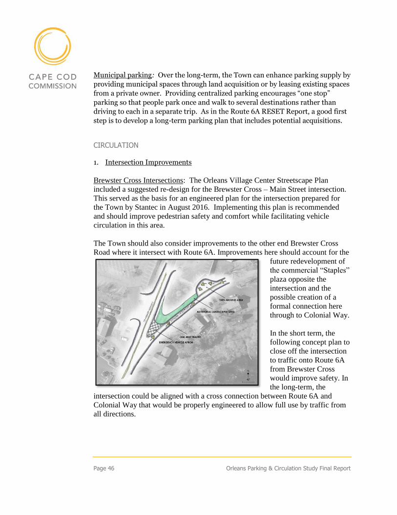
The Town should also consider improvements to the other end Brewster Cross
Road where it intersect with Route 6A. Improvements here should account for the
future redevelopment of
the commercial “Staples”
plaza opposite the
intersection and the
possible creation of a
formal connection here
through to Colonial Way.
In the short term, the
following concept plan to
close off the intersection
to traffic onto Route 6A
from Brewster Cross
would improve safety. In
the long-term, the
intersection could be aligned with a cross connection between Route 6A and
Colonial Way that would be properly engineered to allow full use by traffic from
all directions.
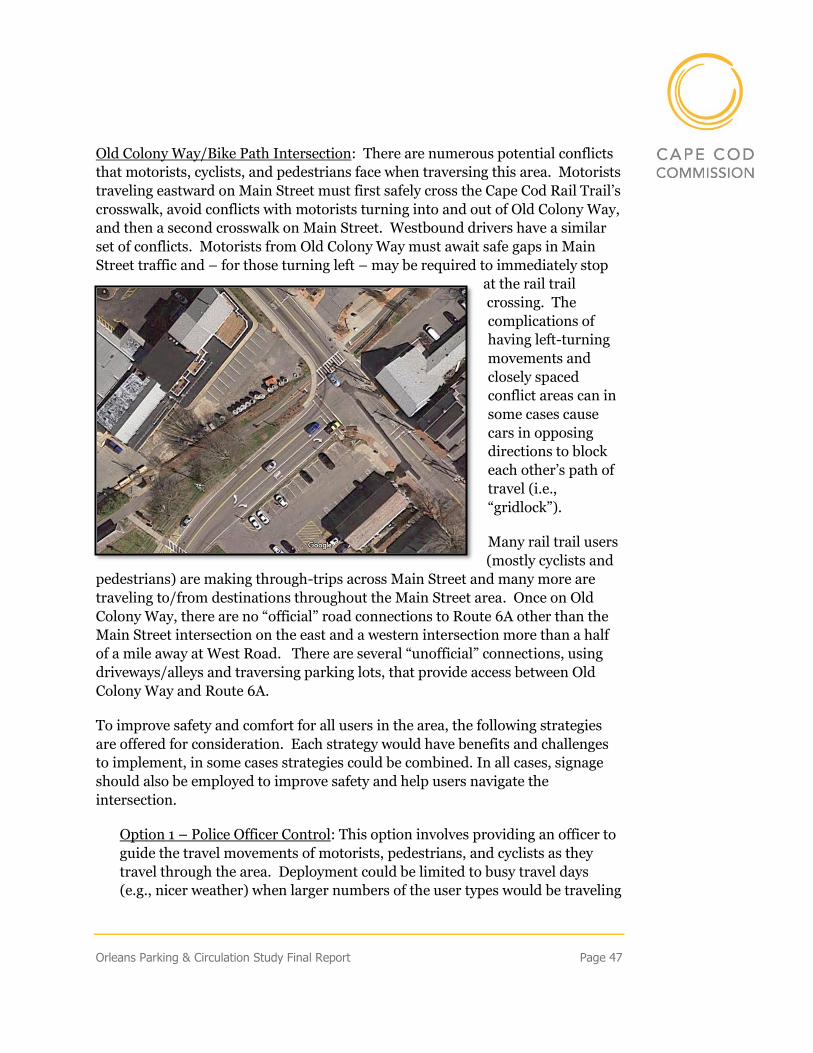
Orleans Parking & Circulation Study Final Report Page 47
Old Colony Way/Bike Path Intersection: There are numerous potential conflicts
that motorists, cyclists, and pedestrians face when traversing this area. Motorists
traveling eastward on Main Street must first safely cross the Cape Cod Rail Trail’s
crosswalk, avoid conflicts with motorists turning into and out of Old Colony Way,
and then a second crosswalk on Main Street. Westbound drivers have a similar
set of conflicts. Motorists from Old Colony Way must await safe gaps in Main
Street traffic and – for those turning left – may be required to immediately stop
at the rail trail
crossing. The
complications of
having left-turning
movements and
closely spaced
conflict areas can in
some cases cause
cars in opposing
directions to block
each other’s path of
travel (i.e.,
“gridlock”).
Many rail trail users
(mostly cyclists and
pedestrians) are making through-trips across Main Street and many more are
traveling to/from destinations throughout the Main Street area. Once on Old
Colony Way, there are no “official” road connections to Route 6A other than the
Main Street intersection on the east and a western intersection more than a half
of a mile away at West Road. There are several “unofficial” connections, using
driveways/alleys and traversing parking lots, that provide access between Old
Colony Way and Route 6A.
To improve safety and comfort for all users in the area, the following strategies
are offered for consideration. Each strategy would have benefits and challenges
to implement, in some cases strategies could be combined. In all cases, signage
should also be employed to improve safety and help users navigate the
intersection.
Option 1 – Police Officer Control: This option involves providing an officer to
guide the travel movements of motorists, pedestrians, and cyclists as they
travel through the area. Deployment could be limited to busy travel days
(e.g., nicer weather) when larger numbers of the user types would be traveling
Page 48 Orleans Parking & Circulation Study Final Report
in the area. This alternative is essentially a “no-build” option, requiring no
physical changes, but it would still require the expense of annual staffing.
Option 2 – Relocation of Old Colony Way: Under Option 2, the eastern end of
Old Colony Way would be relocated approximately 60 feet to the south of its
current intersection with Main Street, moving it farther away from the Rail
Trail. This would require the elimination of the existing public parking lot
located on the southwest quadrant of the intersection. The goal of this option
would be to increase separation of the Old Colony Way intersection from the
Cape Cod Rail Trail crossing.
Option 3 – Create Alternative Connections: Mirroring the recommendation
below to improve circulation by creating new connections, this option focuses
on creating a formal connector road between Old Colony Way and Route 6A
that could serve as an alternative route to Main Street. In combination with
this, the Town could consider eliminating the current intersection between
Old Colony and Main Street, if after a testing period, the new connector road
does not reduce traffic at the existing intersection.
Option 4 – Bicycle/Pedestrian Bridge over Main Street: The construction of a
new Cape Cod Rail Trail bridge over Main Street would eliminate conflicts
between motorists and trail users currently crossing at street level.
Alternative ground level connections would need to be fashioned to attract
rail users to the Village Center and allow access from the center to the trail.
The connector paths should allow access on both sides of Main Street and
connect to the public parking area at Depot Square.
2. Create New Connections, Complete Sidewalks and Crosswalks
Promoting safe and convenient bicycle and pedestrian accommodations with the
Village Center requires a network analysis that extends beyond the intersections.
Connections to and between destinations will allow residents and visitors the
ability experience the Village Center by parking just once or eliminating the
vehicle trip all together.
There are a number of opportunities to create new connections between the
major streets serving the Orleans Village Center. In some cases, the need is for
improved pedestrian or bike connections while at other locations, full automobile
connections would provide the greatest benefit. The following map illustrates
existing and potential new interconnections within the Village core. (Full size
maps are provided in Appendix 6.)
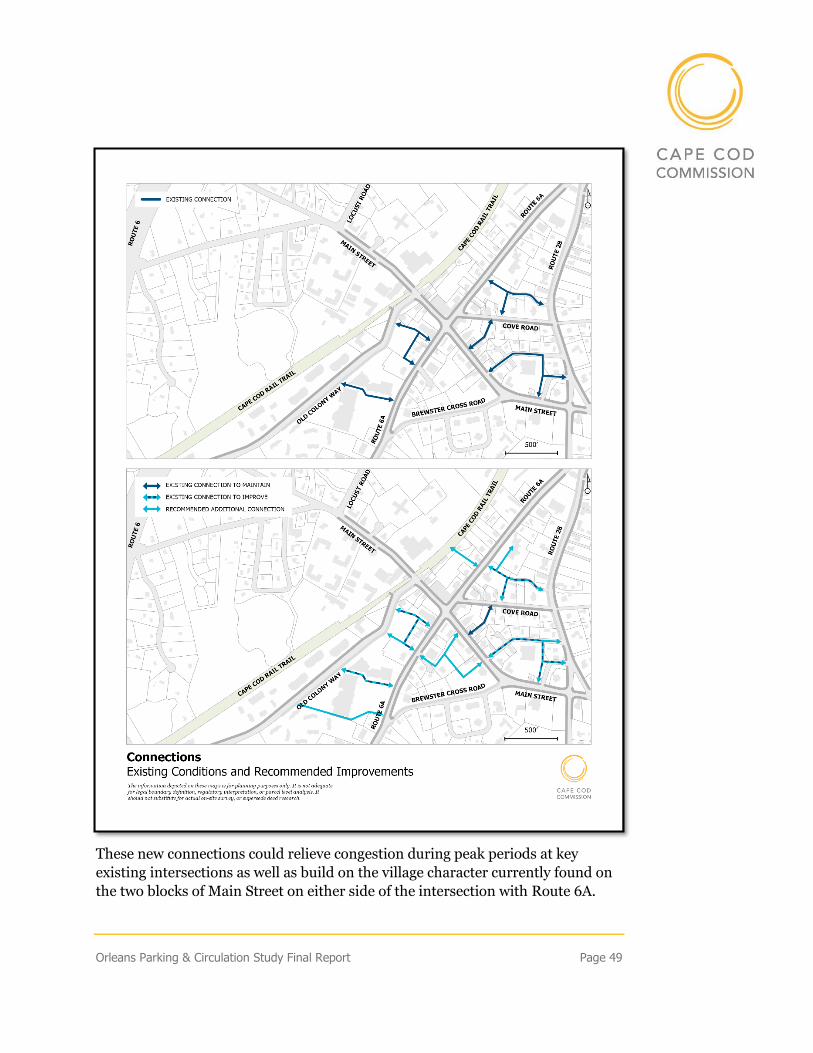
Orleans Parking & Circulation Study Final Report Page 49
These new connections could relieve congestion during peak periods at key
existing intersections as well as build on the village character currently found on
the two blocks of Main Street on either side of the intersection with Route 6A.
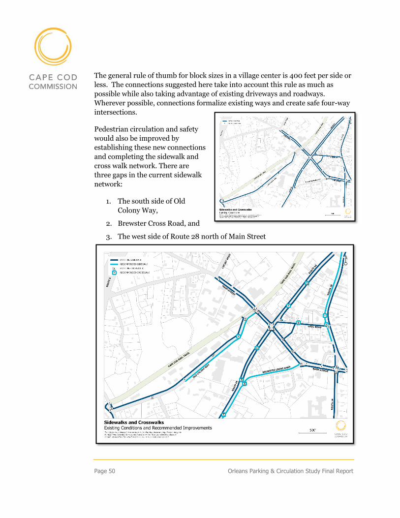
Page 50 Orleans Parking & Circulation Study Final Report
The general rule of thumb for block sizes in a village center is 400 feet per side or
less. The connections suggested here take into account this rule as much as
possible while also taking advantage of existing driveways and roadways.
Wherever possible, connections formalize existing ways and create safe four-way
intersections.
Pedestrian circulation and safety
would also be improved by
establishing these new connections
and completing the sidewalk and
cross walk network. There are
three gaps in the current sidewalk
network:
1. The south side of Old
Colony Way,
2. Brewster Cross Road, and
3. The west side of Route 28 north of Main Street
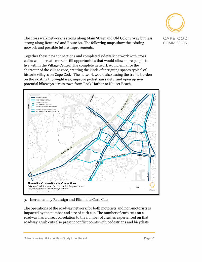
Orleans Parking & Circulation Study Final Report Page 51
The cross walk network is strong along Main Street and Old Colony Way but less
strong along Route 28 and Route 6A. The following maps show the existing
network and possible future improvements.
Together these new connections and completed sidewalk network with cross
walks would create more in-fill opportunities that would allow more people to
live within the Village Center. The complete network would enhance the
character of the village core, creating the kinds of intriguing spaces typical of
historic villages on Cape Cod. The network would also easing the traffic burden
on the existing thoroughfares, improve pedestrian safety, and open up new
potential bikeways across town from Rock Harbor to Nauset Beach.
3. Incrementally Redesign and Eliminate Curb Cuts
The operations of the roadway network for both motorists and non-motorists is
impacted by the number and size of curb cut. The number of curb cuts on a
roadway has a direct correlation to the number of crashes experienced on that
roadway. Curb cuts also present conflict points with pedestrians and bicyclists
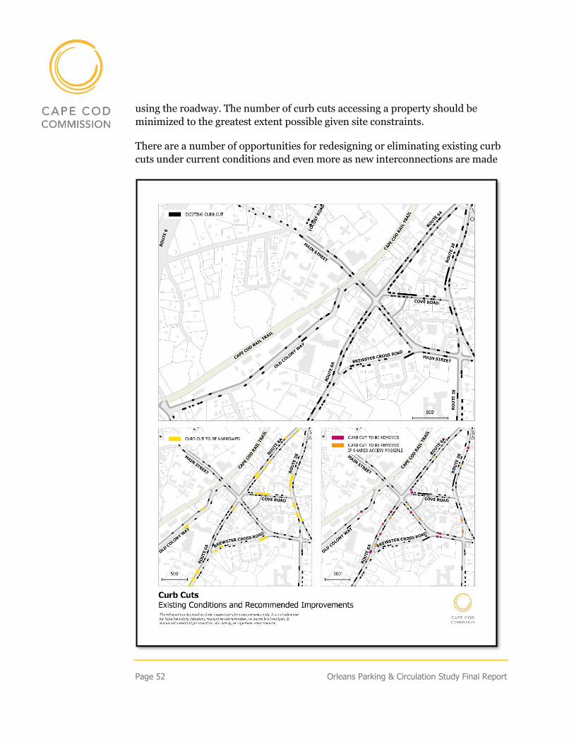
Page 52 Orleans Parking & Circulation Study Final Report
using the roadway. The number of curb cuts accessing a property should be
minimized to the greatest extent possible given site constraints.
There are a number of opportunities for redesigning or eliminating existing curb
cuts under current conditions and even more as new interconnections are made
Orleans Parking & Circulation Study Final Report Page 53
over time. The maps identify the existing curb cuts within the study area as well
as highlight those that could be investigated for potential improvements. This
analysis was done at the planning level; individual site constraints will need to be
considered when evaluating potential curb cut modifications.
Excessively wide curb cuts present a hazard to pedestrians and can cause
additional conflicts for motorists. Curbs cuts that appear excessively wide given
their function are presented on the map. Curb cut redesign should be considered
whenever a property is redeveloped. These opportunities are shown in yellow on
the map above and would improve the safety of over twenty curb cuts.
There are also a number of curb cuts that could be eliminated today – these are
shown in red on the map above. These could be removed without any significant
site changes given alternate access points that currently exist. Others would
require an agreement between property owners for shared access to allow a curb
cut to be removed – these are denoted in orange. Future connections between
parcels and between roads would also provide an opportunity to reduce curb cuts
and improve circulation for motorists and non-motorists.
Page 54 Orleans Parking & Circulation Study Final Report
Appendices
APPENDIX 1 - SCOPE OF WORK – TASKS & PROJECT TEAM
Task 1 – Background
Commission staff will review existing planning documents prepared by the town
including the Local Comprehensive Plan, the 2004 Parking and Circulation
Study, the Village Center Streetscape Plan, the 6A RESET project Final Report,
the two Market Studies completed by FinePoint Associates, and any other studies
that the Town identifies as beneficial. The zoning by-law, other parking or road
configuration standards, and data provided by the Town will also be reviewed by
staff. Staff will identify data gaps that need to be addressed under Task 2: Data
Collection.
Task 2 – Data Collection and Inventory
Commission staff will visit the study area to evaluate and photograph existing
conditions. Data collection will be done in the spring and during the summer
peak.
1. Parking Data & Inventory:
Commission staff will inventory private and public parking facilities in downtown
Orleans. The inventory will include parking lots and on-street parking. Variables
collected will include location, number of spaces, ownership, pricing, and
utilization. The occupancy rate of each parking area will be measured by
counting the number of available spaces at various times of the day during early
spring and the summer peak. To the extent possible, the origin of different users
will be sampled using license plates. The locations to be studied are:
1. Main Street on street parking (Old Colony to Route 28)
2. Old Colony Way on street parking
3. The Depot Square parking lot (off Old Colony Way)
4. The parking lot at the corner of Old Colony and Main Street
5. The CVS/Chocolate Sparrow parking lot
Orleans Parking & Circulation Study Final Report Page 55
6. The parking lot at the Orleans Marketplace
7. The parking lot behind Mahoney’s
8. The parking lots on Cove Road, behind banks on Main Street
9. The parking lot adjacent to Land Ho restaurant
10. Post Office Square parking lot
11. Friends Market parking lot
12. Library parking lot
13. Nauset Regional Middle School parking lot
1. Circulation Data:
Commission staff will compile its existing traffic counts in the study area and
complete additional counts of autos, trucks, bicyclists, and pedestrians as
necessary. The roadway geometry, traffic volumes, turning movement counts,
and crash incidence will be collected for different intersections in the study area.
The intersections to be evaluated are:
1. Main Street and Old Colony Way
2. Route 6A/Main Street*
3. Route 6A/Cove Road
4. Cove Road/Route 28
5. Route 6A Brewster Cross Road
6. Main Street and Brewster Cross Road
7. Main Street/Route 28*
* These intersections have already been re-designed to improve safety and have
funding identified in the Transportation Improvement Program (TIP) and will
not therefore be evaluated as intensively.
Task 3 – Existing Conditions
Based on the information reviewed in Task 1 and data collected in Task 2,
Commission staff will develop an assessment of existing parking and circulation
conditions within the study area. This assessment will use maps, graphs, and
tables to explain today’s conditions and highlight any issues identified through
the analysis.
Page 56 Orleans Parking & Circulation Study Final Report
Task 5 – Future Development Impact Assessment
Commission staff will do an initial evaluation of how an increase in housing along
with some additional commercial development will impact circulation and
parking demand within the Village Center study area. The factors evaluated will
include potential changes in traffic volumes, levels of service, parking utilization,
and safety for vehicles, bikes, and pedestrians. Commission staff will evaluate and
present the impact of up to three (3) growth scenarios provided by the Orleans
Planning Board and Town Planner.
Task 4 – Options to Improve Parking & Circulation
Based on the existing conditions assessment, best management practices and
input by town staff and the Planning Board, Commission staff will develop a set
of options that could be implemented to help accommodate future growth and
correct the issues identified. Options may include suggested revisions to parking
policies, consideration of paid parking, development of new parking options, as
well as signage and information technology options for parking management and
programs to encourage alternative forms of transportation. For circulation, they
could include changes in circulation patterns, geometric and/or traffic control
improvements at select intersections, and/or options aimed at promoting non-
auto transportation. Illustrations of different parking and circulation options will
be developed as needed.
Project Team
• Leslie Richardson, Chief Economic Development Officer (Project
Manager)
• Sharon Rooney, Chief Planner & Landscape Architect
• Martha Hevenor, Planner II, Bicycle and Pedestrian Coordinator
• Glenn Cannon, PE, Director of Technical Services
• Lev A. Malakhoff, Senior Transportation Engineer
• Steven Tupper, Technical Services Planner
• Patrick Tierney, Technical Services Planner
• Traffic Techs
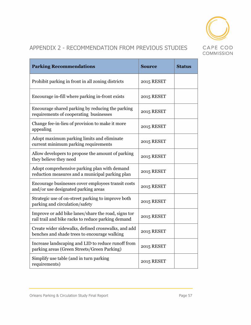
Orleans Parking & Circulation Study Final Report Page 57
APPENDIX 2 - RECOMMENDATION FROM PREVIOUS STUDIES
Parking Recommendations Source Status
Prohibit parking in front in all zoning districts 2015 RESET
Encourage in-fill where parking in-front exists 2015 RESET
Encourage shared parking by reducing the parking
requirements of cooperating businesses 2015 RESET
Change fee-in-lieu of provision to make it more
appealing 2015 RESET
Adopt maximum parking limits and eliminate
current minimum parking requirements 2015 RESET
Allow developers to propose the amount of parking
they believe they need 2015 RESET
Adopt comprehensive parking plan with demand
reduction measures and a municipal parking plan 2015 RESET
Encourage businesses cover employees transit costs
and/or use designated parking areas 2015 RESET
Strategic use of on-street parking to improve both
parking and circulation/safety 2015 RESET
Improve or add bike lanes/share the road, signs tor
rail trail and bike racks to reduce parking demand 2015 RESET
Create wider sidewalks, defined crosswalks, and add
benches and shade trees to encourage walking 2015 RESET
Increase landscaping and LID to reduce runoff from
parking areas (Green Streets/Green Parking) 2015 RESET
Simplify use table (and in turn parking
requirements) 2015 RESET
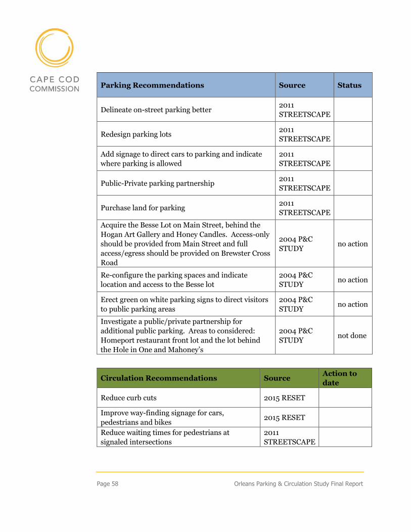
Page 58 Orleans Parking & Circulation Study Final Report
Parking Recommendations Source Status
Delineate on-street parking better 2011
STREETSCAPE
Redesign parking lots 2011
STREETSCAPE
Add signage to direct cars to parking and indicate
where parking is allowed
2011
STREETSCAPE
Public-Private parking partnership 2011
STREETSCAPE
Purchase land for parking 2011
STREETSCAPE
Acquire the Besse Lot on Main Street, behind the
Hogan Art Gallery and Honey Candles. Access-only
should be provided from Main Street and full
access/egress should be provided on Brewster Cross
Road
2004 P&C
STUDY no action
Re-configure the parking spaces and indicate
location and access to the Besse lot
2004 P&C
STUDY no action
Erect green on white parking signs to direct visitors
to public parking areas
2004 P&C
STUDY no action
Investigate a public/private partnership for
additional public parking. Areas to considered:
Homeport restaurant front lot and the lot behind
the Hole in One and Mahoney’s
2004 P&C
STUDY not done
Circulation Recommendations Source Action to
date
Reduce curb cuts 2015 RESET
Improve way-finding signage for cars,
pedestrians and bikes 2015 RESET
Reduce waiting times for pedestrians at
signaled intersections
2011
STREETSCAPE
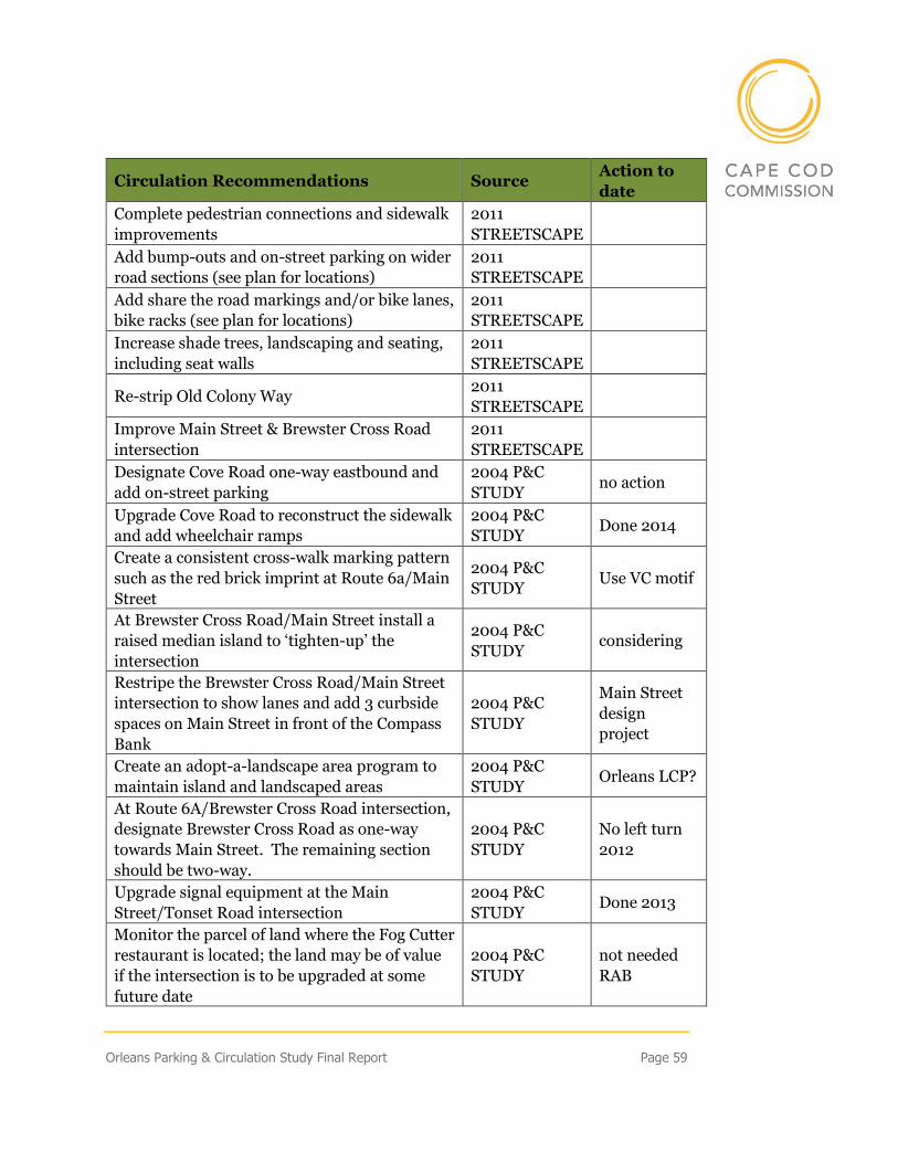
Orleans Parking & Circulation Study Final Report Page 59
Circulation Recommendations Source Action to
date
Complete pedestrian connections and sidewalk
improvements
2011
STREETSCAPE
Add bump-outs and on-street parking on wider
road sections (see plan for locations)
2011
STREETSCAPE
Add share the road markings and/or bike lanes,
bike racks (see plan for locations)
2011
STREETSCAPE
Increase shade trees, landscaping and seating,
including seat walls
2011
STREETSCAPE
Re-strip Old Colony Way 2011
STREETSCAPE
Improve Main Street & Brewster Cross Road
intersection
2011
STREETSCAPE
Designate Cove Road one-way eastbound and
add on-street parking
2004 P&C
STUDY no action
Upgrade Cove Road to reconstruct the sidewalk
and add wheelchair ramps
2004 P&C
STUDY Done 2014
Create a consistent cross-walk marking pattern
such as the red brick imprint at Route 6a/Main
Street
2004 P&C
STUDY Use VC motif
At Brewster Cross Road/Main Street install a
raised median island to ‘tighten-up’ the
intersection
2004 P&C
STUDY considering
Restripe the Brewster Cross Road/Main Street
intersection to show lanes and add 3 curbside
spaces on Main Street in front of the Compass
Bank
2004 P&C
STUDY
Main Street
design
project
Create an adopt-a-landscape area program to
maintain island and landscaped areas
2004 P&C
STUDY Orleans LCP?
At Route 6A/Brewster Cross Road intersection,
designate Brewster Cross Road as one-way
towards Main Street. The remaining section
should be two-way.
2004 P&C
STUDY
No left turn
2012
Upgrade signal equipment at the Main
Street/Tonset Road intersection
2004 P&C
STUDY Done 2013
Monitor the parcel of land where the Fog Cutter
restaurant is located; the land may be of value
if the intersection is to be upgraded at some
future date
2004 P&C
STUDY
not needed
RAB
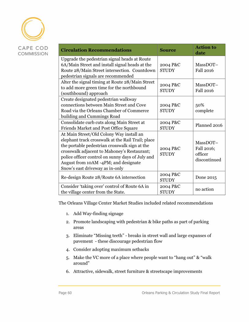
Page 60 Orleans Parking & Circulation Study Final Report
Circulation Recommendations Source Action to
date
Upgrade the pedestrian signal heads at Route
6A/Main Street and install signal heads at the
Route 28/Main Street intersection. Countdown
pedestrian signals are recommended
2004 P&C
STUDY
MassDOT–
Fall 2016
Alter the signal timing at Route 28/Main Street
to add more green time for the northbound
(southbound) approach
2004 P&C
STUDY
MassDOT–
Fall 2016
Create designated pedestrian walkway
connections between Main Street and Cove
Road via the Orleans Chamber of Commerce
building and Cummings Road
2004 P&C
STUDY
50%
complete
Consolidate curb cuts along Main Street at
Friends Market and Post Office Square
2004 P&C
STUDY Planned 2016
At Main Street/Old Colony Way install an
elephant track crosswalk at the Rail Trail; place
the portable pedestrian crosswalk sign at the
crosswalk adjacent to Mahoney’s Restaurant;
police officer control on sunny days of July and
August from 10AM -4PM; and designate
Snow’s east driveway as in-only
2004 P&C
STUDY
MassDOT–
Fall 2016;
officer
discontinued
Re-design Route 28/Route 6A intersection 2004 P&C
STUDY Done 2015
Consider ‘taking over’ control of Route 6A in
the village center from the State.
2004 P&C
STUDY no action
The Orleans Village Center Market Studies included related recommendations
1. Add Way-finding signage
2. Promote landscaping with pedestrian & bike paths as part of parking
areas
3. Eliminate “Missing teeth” - breaks in street wall and large expanses of
pavement - these discourage pedestrian flow
4. Consider adopting maximum setbacks
5. Make the VC more of a place where people want to “hang out” & “walk
around”
6. Attractive, sidewalk, street furniture & streetscape improvements
Orleans Parking & Circulation Study Final Report Page 61
7. More bike racks throughout the VC; market the VC as bike-friendly
8. Create attractive connection/cut through between Main Street and Cove
Road
9. Assess parking situation. Determine how current spots are being used
10. Determine if system that promoted employee parking in designated areas
would alleviate problem
11. Reassess previous concept of developing parking lot behind Gotland
Horse (approx. 100 spaces)
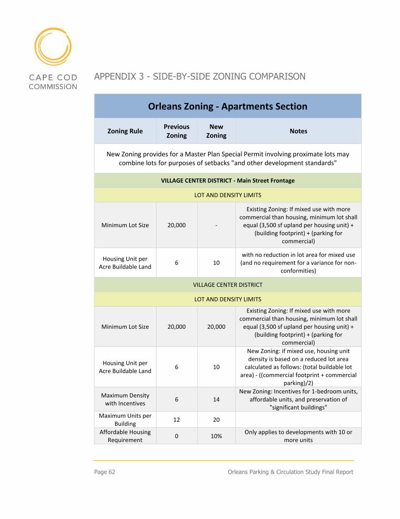
Page 62 Orleans Parking & Circulation Study Final Report
APPENDIX 3 - SIDE-BY-SIDE ZONING COMPARISON
Orleans Zoning - Apartments Section
Zoning Rule Previous Zoning
New Zoning
Notes
New Zoning provides for a Master Plan Special Permit involving proximate lots may combine lots for purposes of setbacks "and other development standards"
VILLAGE CENTER DISTRICT - Main Street Frontage
LOT AND DENSITY LIMITS
Minimum Lot Size 20,000 -
Existing Zoning: If mixed use with more commercial than housing, minimum lot shall
equal (3,500 sf upland per housing unit) + (building footprint) + (parking for
commercial)
Housing Unit per Acre Buildable Land
6 10 with no reduction in lot area for mixed use (and no requirement for a variance for non-
conformities)
VILLAGE CENTER DISTRICT
LOT AND DENSITY LIMITS
Minimum Lot Size 20,000 20,000
Existing Zoning: If mixed use with more commercial than housing, minimum lot shall
equal (3,500 sf upland per housing unit) + (building footprint) + (parking for
commercial)
Housing Unit per Acre Buildable Land
6 10
New Zoning: if mixed use, housing unit density is based on a reduced lot area
calculated as follows: (total buildable lot area) - ((commercial footprint + commercial
parking)/2)
Maximum Density with Incentives
6 14 New Zoning: Incentives for 1-bedroom units,
affordable units, and preservation of "significant buildings"
Maximum Units per Building
12 20
Affordable Housing Requirement
0 10% Only applies to developments with 10 or
more units
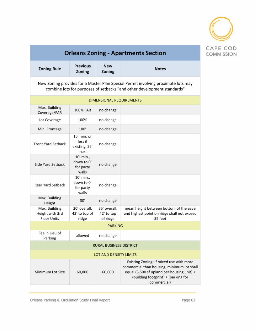
Orleans Parking & Circulation Study Final Report Page 63
Orleans Zoning - Apartments Section
Zoning Rule Previous Zoning
New Zoning
Notes
New Zoning provides for a Master Plan Special Permit involving proximate lots may combine lots for purposes of setbacks "and other development standards"
DIMENSIONAL REQUIREMENTS
Max. Building Coverage/FAR
100% FAR no change
Lot Coverage 100% no change
Min. Frontage 100’ no change
Front Yard Setback
15’ min. or less if
existing, 25’ max.
no change
Side Yard Setback
10’ min., down to 0’ for party
walls
no change
Rear Yard Setback
10’ min., down to 0’ for party
walls
no change
Max. Building Height
30’ no change
Max. Building Height with 3rd
Floor Units
30’ overall, 42’ to top of
ridge
35’ overall, 42’ to top of ridge
mean height between bottom of the eave and highest point on ridge shall not exceed
35 feet
PARKING
Fee in Lieu of Parking
allowed no change
RURAL BUSINESS DISTRICT
LOT AND DENSITY LIMITS
Minimum Lot Size 60,000 60,000
Existing Zoning: If mixed use with more commercial than housing, minimum lot shall
equal (3,500 sf upland per housing unit) + (building footprint) + (parking for
commercial)
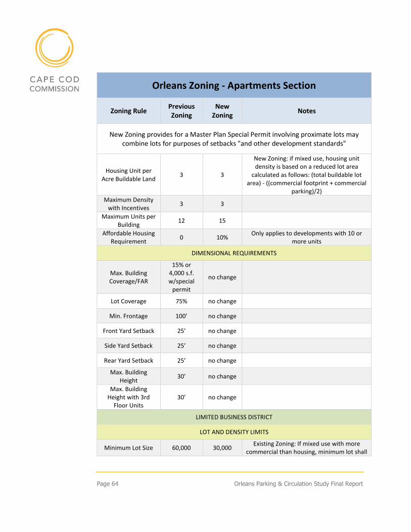
Page 64 Orleans Parking & Circulation Study Final Report
Orleans Zoning - Apartments Section
Zoning Rule Previous Zoning
New Zoning
Notes
New Zoning provides for a Master Plan Special Permit involving proximate lots may combine lots for purposes of setbacks "and other development standards"
Housing Unit per Acre Buildable Land
3 3
New Zoning: if mixed use, housing unit density is based on a reduced lot area
calculated as follows: (total buildable lot area) - ((commercial footprint + commercial
parking)/2)
Maximum Density with Incentives
3 3
Maximum Units per Building
12 15
Affordable Housing Requirement
0 10% Only applies to developments with 10 or
more units
DIMENSIONAL REQUIREMENTS
Max. Building Coverage/FAR
15% or 4,000 s.f. w/special
permit
no change
Lot Coverage 75% no change
Min. Frontage 100’ no change
Front Yard Setback 25’ no change
Side Yard Setback 25’ no change
Rear Yard Setback 25’ no change
Max. Building Height
30’ no change
Max. Building Height with 3rd
Floor Units 30’ no change
LIMITED BUSINESS DISTRICT
LOT AND DENSITY LIMITS
Minimum Lot Size 60,000 30,000 Existing Zoning: If mixed use with more
commercial than housing, minimum lot shall
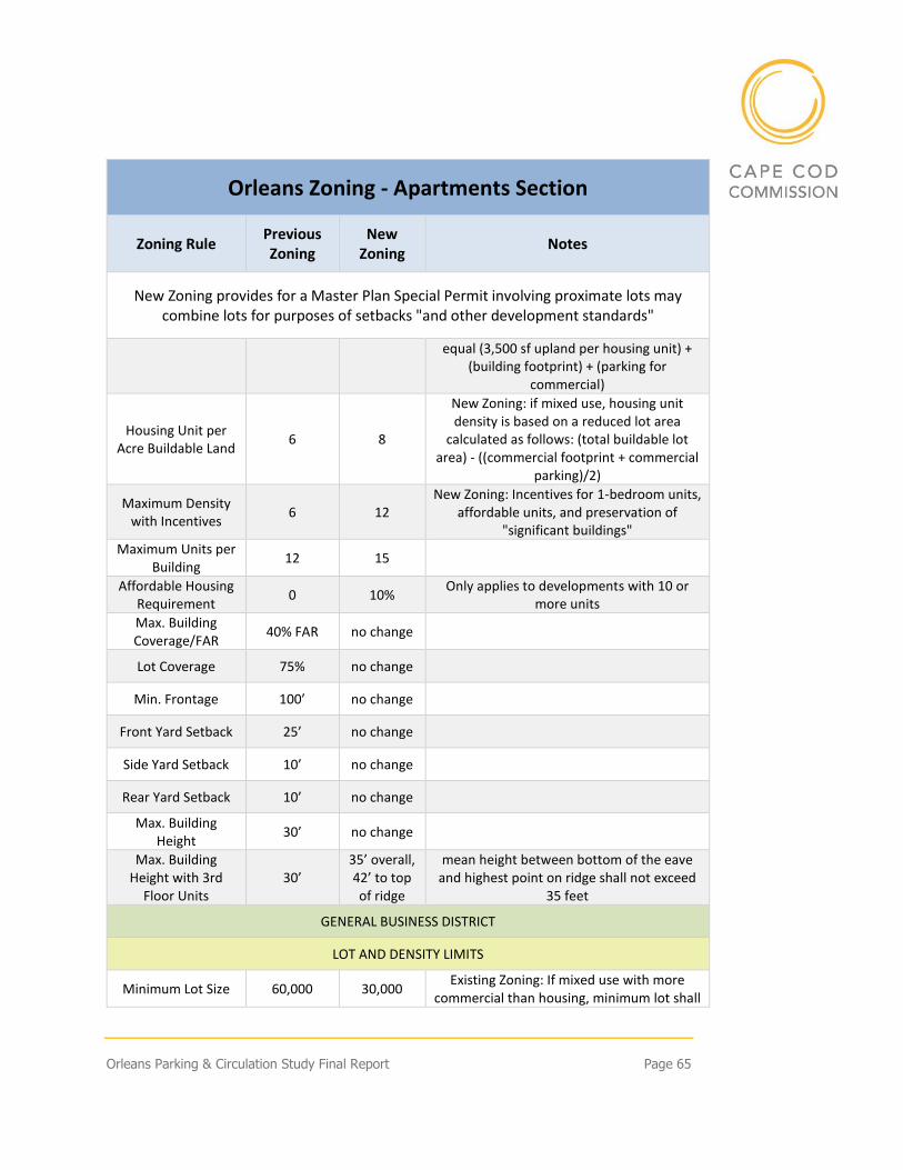
Orleans Parking & Circulation Study Final Report Page 65
Orleans Zoning - Apartments Section
Zoning Rule Previous Zoning
New Zoning
Notes
New Zoning provides for a Master Plan Special Permit involving proximate lots may combine lots for purposes of setbacks "and other development standards"
equal (3,500 sf upland per housing unit) + (building footprint) + (parking for
commercial)
Housing Unit per Acre Buildable Land
6 8
New Zoning: if mixed use, housing unit density is based on a reduced lot area
calculated as follows: (total buildable lot area) - ((commercial footprint + commercial
parking)/2)
Maximum Density with Incentives
6 12 New Zoning: Incentives for 1-bedroom units,
affordable units, and preservation of "significant buildings"
Maximum Units per Building
12 15
Affordable Housing Requirement
0 10% Only applies to developments with 10 or
more units
Max. Building Coverage/FAR
40% FAR no change
Lot Coverage 75% no change
Min. Frontage 100’ no change
Front Yard Setback 25’ no change
Side Yard Setback 10’ no change
Rear Yard Setback 10’ no change
Max. Building Height
30’ no change
Max. Building Height with 3rd
Floor Units 30’
35’ overall, 42’ to top of ridge
mean height between bottom of the eave and highest point on ridge shall not exceed
35 feet
GENERAL BUSINESS DISTRICT
LOT AND DENSITY LIMITS
Minimum Lot Size 60,000 30,000 Existing Zoning: If mixed use with more
commercial than housing, minimum lot shall
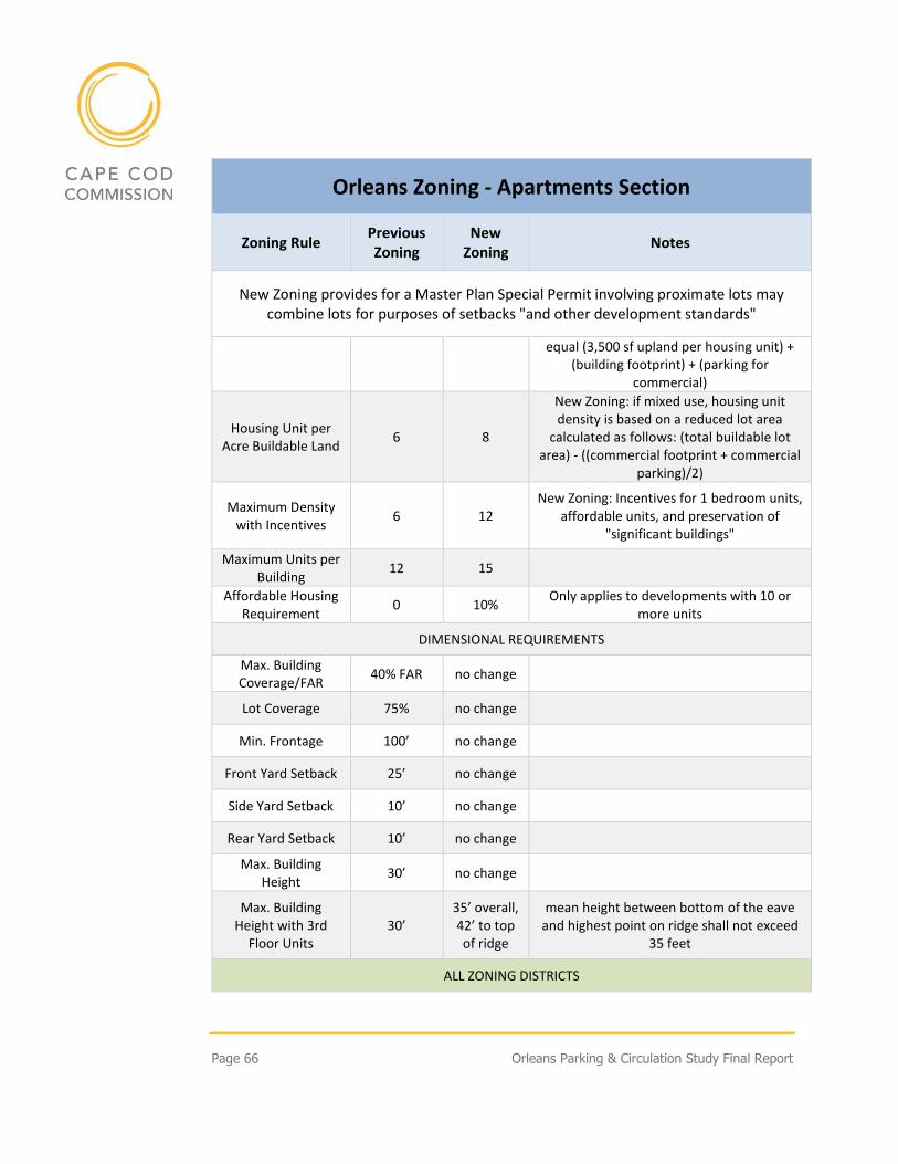
Page 66 Orleans Parking & Circulation Study Final Report
Orleans Zoning - Apartments Section
Zoning Rule Previous Zoning
New Zoning
Notes
New Zoning provides for a Master Plan Special Permit involving proximate lots may combine lots for purposes of setbacks "and other development standards"
equal (3,500 sf upland per housing unit) + (building footprint) + (parking for
commercial)
Housing Unit per Acre Buildable Land
6 8
New Zoning: if mixed use, housing unit density is based on a reduced lot area
calculated as follows: (total buildable lot area) - ((commercial footprint + commercial
parking)/2)
Maximum Density with Incentives
6 12 New Zoning: Incentives for 1 bedroom units,
affordable units, and preservation of "significant buildings"
Maximum Units per Building
12 15
Affordable Housing Requirement
0 10% Only applies to developments with 10 or
more units
DIMENSIONAL REQUIREMENTS
Max. Building Coverage/FAR
40% FAR no change
Lot Coverage 75% no change
Min. Frontage 100’ no change
Front Yard Setback 25’ no change
Side Yard Setback 10’ no change
Rear Yard Setback 10’ no change
Max. Building Height
30’ no change
Max. Building Height with 3rd
Floor Units 30’
35’ overall, 42’ to top of ridge
mean height between bottom of the eave and highest point on ridge shall not exceed
35 feet
ALL ZONING DISTRICTS
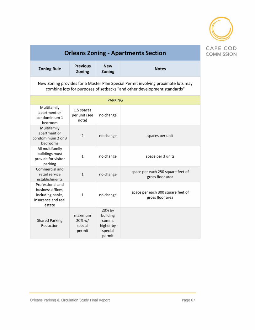
Orleans Parking & Circulation Study Final Report Page 67
Orleans Zoning - Apartments Section
Zoning Rule Previous Zoning
New Zoning
Notes
New Zoning provides for a Master Plan Special Permit involving proximate lots may combine lots for purposes of setbacks "and other development standards"
PARKING
Multifamily apartment or
condominium 1 bedroom
1.5 spaces per unit (see
note) no change
Multifamily apartment or
condominium 2 or 3 bedrooms
2 no change spaces per unit
All multifamily buildings must
provide for visitor parking
1 no change space per 3 units
Commercial and retail service
establishments 1 no change
space per each 250 square feet of gross floor area
Professional and business offices, including banks,
insurance and real estate
1 no change space per each 300 square feet of
gross floor area
Shared Parking Reduction
maximum 20% w/ special permit
20% by building comm,
higher by special permit
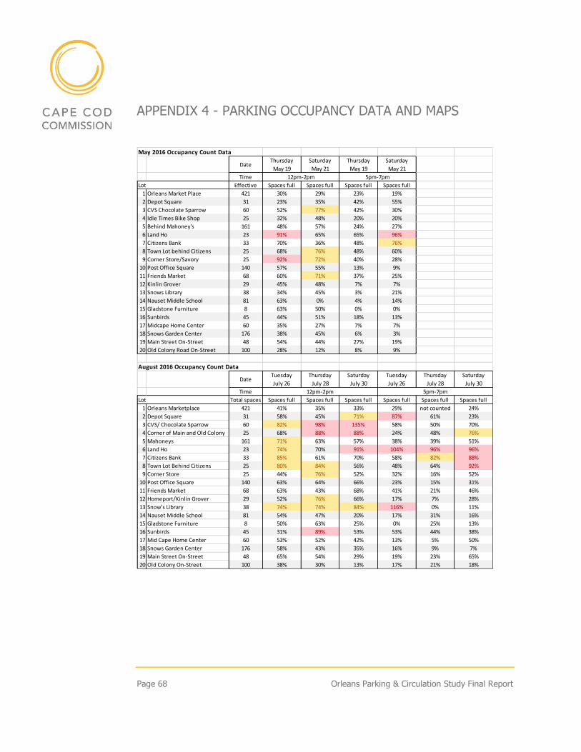
Page 68 Orleans Parking & Circulation Study Final Report
APPENDIX 4 - PARKING OCCUPANCY DATA AND MAPS
May 2016 Occupancy Count Data
DateThursday
May 19
Saturday
May 21
Thursday
May 19
Saturday
May 21
Time
Effective Spaces full Spaces full Spaces full Spaces full
1 Orleans Market Place 421 30% 29% 23% 19%
2 Depot Square 31 23% 35% 42% 55%
3 CVS Chocolate Sparrow 60 52% 77% 42% 30%
4 Idle Times Bike Shop 25 32% 48% 20% 20%
5 Behind Mahoney's 161 48% 57% 24% 27%
6 Land Ho 23 91% 65% 65% 96%
7 Citizens Bank 33 70% 36% 48% 76%
8 Town Lot behind Citizens 25 68% 76% 48% 60%
9 Corner Store/Savory 25 92% 72% 40% 28%
10 Post Office Square 140 57% 55% 13% 9%
11 Friends Market 68 60% 71% 37% 25%
12 Kinlin Grover 29 45% 48% 7% 7%
13 Snows Library 38 34% 45% 3% 21%
14 Nauset Middle School 81 63% 0% 4% 14%
15 Gladstone Furniture 8 63% 50% 0% 0%
16 Sunbirds 45 44% 51% 18% 13%
17 Midcape Home Center 60 35% 27% 7% 7%
18 Snows Garden Center 176 38% 45% 6% 3%
19 Main Street On-Street 48 54% 44% 27% 19%
20 Old Colony Road On-Street 100 28% 12% 8% 9%
August 2016 Occupancy Count Data
DateTuesday
July 26
Thursday
July 28
Saturday
July 30
Tuesday
July 26
Thursday
July 28
Saturday
July 30
Time
Total spaces Spaces full Spaces full Spaces full Spaces full Spaces full Spaces full
1 Orleans Marketplace 421 41% 35% 33% 29% not counted 24%
2 Depot Square 31 58% 45% 71% 87% 61% 23%
3 CVS/ Chocolate Sparrow 60 82% 98% 135% 58% 50% 70%
4 Corner of Main and Old Colony 25 68% 88% 88% 24% 48% 76%
5 Mahoneys 161 71% 63% 57% 38% 39% 51%
6 Land Ho 23 74% 70% 91% 104% 96% 96%
7 Citizens Bank 33 85% 61% 70% 58% 82% 88%
8 Town Lot Behind Citizens 25 80% 84% 56% 48% 64% 92%
9 Corner Store 25 44% 76% 52% 32% 16% 52%
10 Post Office Square 140 63% 64% 66% 23% 15% 31%
11 Friends Market 68 63% 43% 68% 41% 21% 46%
12 Homeport/Kinlin Grover 29 52% 76% 66% 17% 7% 28%
13 Snow's Library 38 74% 74% 84% 116% 0% 11%
14 Nauset Middle School 81 54% 47% 20% 17% 31% 16%
15 Gladstone Furniture 8 50% 63% 25% 0% 25% 13%
16 Sunbirds 45 31% 89% 53% 53% 44% 38%
17 Mid Cape Home Center 60 53% 52% 42% 13% 5% 50%
18 Snows Garden Center 176 58% 43% 35% 16% 9% 7%
19 Main Street On-Street 48 65% 54% 29% 19% 23% 65%
20 Old Colony On-Street 100 38% 30% 13% 17% 21% 18%
12pm-2pm 5pm-7pm
12pm-2pm 5pm-7pm
Lot
Lot
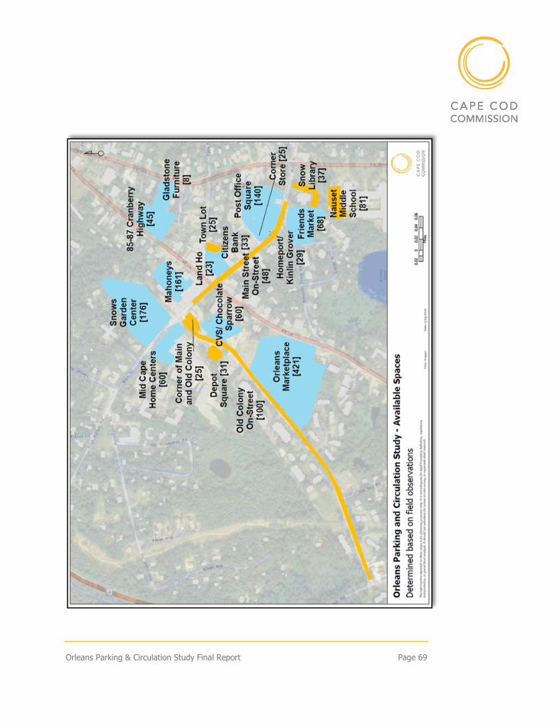
Orleans Parking & Circulation Study Final Report Page 69
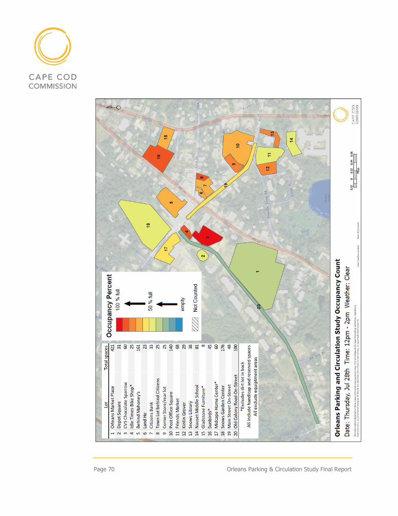
Page 70 Orleans Parking & Circulation Study Final Report
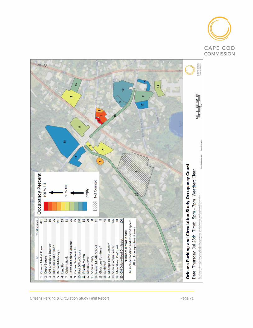
Orleans Parking & Circulation Study Final Report Page 71
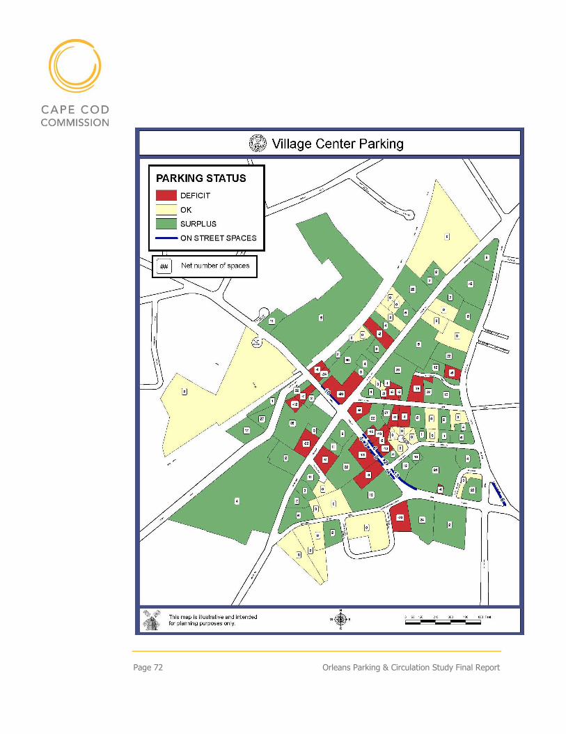
Page 72 Orleans Parking & Circulation Study Final Report
Orleans Parking & Circulation Study Final Report Page 73
APPENDIX 5 – EXAMPLES OF COOPERATIVE PARKING AGREEMENTS
SAMPLE SHARED PARKING AGREEMENTS
Shared parking agreements can be made between two or more private parties or
between a public entity and one or more private parties. The parties can agree on
a shared easement or a shared lease arrangement with detailed provisions on
costs and benefits, including maintenance.
Two samples are included here, the first from the City of Portland Oregon and the
second from the County of Brazos, Texas.
City of Portland, OR - Sample Shared Use Agreement
This Shared Use Agreement for Parking Facilities, entered into this ____ day of
__________, ______, between _______________, hereinafter called lessor
and _________________, hereinafter called lessee.
In consideration of the covenants herein, lessor agrees to share with lessee
certain parking facilities, as is situated in the City of ______________, County
of ________________ and State of ____________, hereinafter called the
facilities, described as:
[Include legal description of location and spaces to be shared here, and
as shown on attachment 1.]
The facilities shall be shared commencing with the ____ day of __________,
______, and ending at 11:59 PM on the ____ day of __________, ______,
for [insert negotiated compensation figures, as appropriate]. The lessee agrees
to pay at [insert payment address] to lessor by the_____ day of each month [or
other payment arrangements].]
Lessor hereby represents that it holds legal title to the facilities.
The parties agree:
Page 74 Orleans Parking & Circulation Study Final Report
1. USE OF FACILITIES
This section should describe the nature of the shared use (exclusive, joint
sections, time(s) and day(s) of week of usage.
-SAMPLE CLAUSE- [Lessee shall have exclusive use of the facilities. The use
shall only be between the hours of 5:30 PM Friday through 5:30 AM
Monday and between the hours of 5:30 PM and5:30 AM Monday through
Thursday.]
2. MAINTENANCE
This section should describe responsibility for aspects of maintenance of the
facilities. This could include cleaning, striping, seal coating, asphalt repair
and more.
-SAMPLE CLAUSE- [Lessor shall provide, as reasonably necessary asphalt
repair work. Lessee and Lessor agree to share striping, seal coating and lot
sweeping at a 50%/50% split based upon mutually accepted maintenance
contracts with outside vendors. Lessor shall maintain lot and landscaping at
or above the current condition, at no additional cost to the lessee.]
3. UTILITIES and TAXES
This section should describe responsibility for utilities and taxes. This could
include electrical, water, sewage, and more.
-SAMPLE CLAUSE- [Lessor shall pay all taxes and utilities associated with
the facilities, including maintenance of existing facility lighting as directed
by standard safety practices.]
4. SIGNAGE
This section should describe signage allowances and restrictions.
-SAMPLE CLAUSE- [Lessee may provide signage, meeting with the written
approval of lessor, designating usage allowances.]
5. ENFORCEMENT
This section should describe any facility usage enforcement methods.
Orleans Parking & Circulation Study Final Report Page 75
-SAMPLE CLAUSE- [Lessee may provide a surveillance officer(s) for
parking safety and usage only for the period of its exclusive use. Lessee and
lessor reserve the right to tow, at owner’s expense, vehicles improperly
parked or abandoned. All towing shall be with the approval of the lessor.]
6. COOPERATION
This section should describe communication relationship.
-SAMPLE CLAUSE- [Lessor and lessee agree to cooperate to the best of their
abilities to mutually use the facilities without disrupting the other party. The
parties agree to meet on occasion to work out any problems that may arise
to the shared use.]
7. INSURANCE
This section should describe insurance requirements for the facilities.
-SAMPLE CLAUSE- [At their own expense, lessor and lessee agree to
maintain liability insurance for the facilities as is standard for their own
business usage.]
8. INDEMNIFICATION
This section should describe indemnification as applicable and negotiated.
This is a very technical section and legal counsel should be consulted for
appropriate language to each and every agreement
-NO SAMPLE CLAUSE PROVIDED-
9. TERMINATION
This section should describe how to or if this agreement can be terminated
and post termination responsibilities.
-SAMPLE CLAUSE- [If lessor transfers ownership, or if part of all of the
facilities are condemned, or access to the facilities is changed or limited,
lessee may, in its sole discretion terminate this agreement without further
liability by giving Lessor not less than 60 days prior written notice. Upon
termination of this agreement, Lessee agrees to remove all signage and
repair damage due to excessive use or abuse. Lessor agrees to give lessee the
right of first refusal on subsequent renewal of this agreement.]
Page 76 Orleans Parking & Circulation Study Final Report
10. SUPPLEMENTAL COVENANTS
This section should contain any additional covenants, rights, responsibilities
and/or agreements.
- NO SAMPLE CLAUSE PROVIDED-
IN WITNESS WHEREOF, the parties have executed this Agreement as of the
Effective Date Set forth at the outset hereof.
[Signature and notarization as appropriate to a legal document and as
appropriate to recording process negotiated between parties.]
State of Texas County of Brazos - Shared Parking Agreement
A Shared Parking Agreement may be revoked by the parties to the agreement
only if off-street parking is provided pursuant to Section 7.2 Off-Street Parking
Standards, or if an Alternative Parking Plan is approved by the Administrator.
THE STATE OF TEXAS COUNTY OF BRAZOS THIS PARKING AGREEMENT is
made and entered into as of the (date) by and between and (property I) and
(property II)
WHEREAS, (name of property owner I) is the owner of (legal description, Vol.,
Page) located at (address) within the City of College Station, Brazos County,
(address) Texas (herein after referred to as " ");
WHEREAS (name property owner II) is the owner of (legal description, Vol.,
Page) located at (address) within the City of College Station, Brazos County,
Texas (herein after referred to as " ");
WHEREAS in order to be used as (list proposed use), (property I) requires
additional off street parking to comply with the parking requirement set forth by
the City of College Station Unified Development Code;
NOW, THEREFORE, in consideration of the mutual covenant and agreements
set forth herein, the sufficiency of which is hereby acknowledged, the parties
hereby agree as follows:
1. Easement Purpose. (by applicant) 2. Grant of Easement.
Orleans Parking & Circulation Study Final Report Page 77
a. b. c. d. The easement is nonexclusive and irrevocable, but only for so long
as (property I) is used for the purposes of (use of property I) e. This Easement shall remain in full force and effect for so long as
the (property I) is used for the purposes of (use of property I). At such time that (property I) is no longer used for purposes of (use of property I) the Easement shall become null and void by its own terms, and (property II) shall not be required to file any release, termination or other document to evidence the termination of this Easement.
MAINTENANCE & LIABILITY: by applicants
No Portion of the drives or parking areas on the (property I) or the
(property II) shall be used for any purpose other than authorized by this
instrument an no fence, barricade or improvement shall be constructed by either
party that would prohibit the use of the (property I) or the (property II) for the
Easement purpose.
It is mutually agreed that the intention of the parties is that this Agreement is for
the private benefit of the parties and their respective successors and assigns and
shall be strictly limited to and for the purposes herein expressed.
The rights and obligations contained in this Agreement and the terms and
condition hereof shall be deemed to be covenants running with the land and
binding upon the parties and their respective successors and assigns.
(signatures of both parties
STATE OF TEXAS COUNTY OF BRAZOS This instrument was acknowledged
before me on (date) by (property owner) Notary Public, State of Texas
STATE OF TEXAS COUNTY OF BRAZOS This instrument was acknowledged
before me on (date) by (property owner) Notary Public, State of Texas
REVOVATION: Failure to comply with the shared parking provisions of Section
7.2.K Alternative Parking Plans, shall constitute a violation of the Unified
Development Ordinance and shall specifically be cause for revocation of a
Certificate of Occupancy or Building Permit.
PROVIDE ATTACHMENTS: Shared Parking Study Form
Page 78 Orleans Parking & Circulation Study Final Report
USEFUL ON-LINE RESOURCES
1. Maximizing Urban-Core Parking with Private Public and Private-Private
Parking Agreements - Convening Findings, Nelson Nygaard, 2015 for
Urban Sustainability Directors Network
This is a comprehensive toolkit on shared parking. It lays out the value of
shared parking to property owners and communities, discusses types of
shared parking agreements, issues to consider, and a process list for
making shared parking a reality. The document includes slides from
presentations that could be useful in explaining the value of shared
parking.
https://www.usdn.org/uploads/cms/documents/2015usdnconvening_su
mmary.pdf
2. Shared Parking – Sharing Parking Facilities Among Multiple Users, TDM
Encyclopedia, Victoria Transport Policy Institute, updated 2015
Another comprehensive explanation of shared parking covering the
benefits and costs of shared parking, its implementation, impacts, best
practices, and application in different development settings. Case studies
and numerous resources are also included on the site.
http://www.vtpi.org/tdm/tdm89.htm
3. Sub-regional Planning Tools, Shared Parking, The Houston-Galveston
Area Council
A brief outline of shared parking, its benefits and implementation, and
resources for more information and sample ordinances.
http://subregional.h-
gac.com/toolbox/Transportation_and_Mobility/Parking_Management/S
hared%20Parking-final.html

Orleans Parking & Circulation Study Final Report Page 79
APPENDIX 6 – CICULATION NEXT STEPS MAP
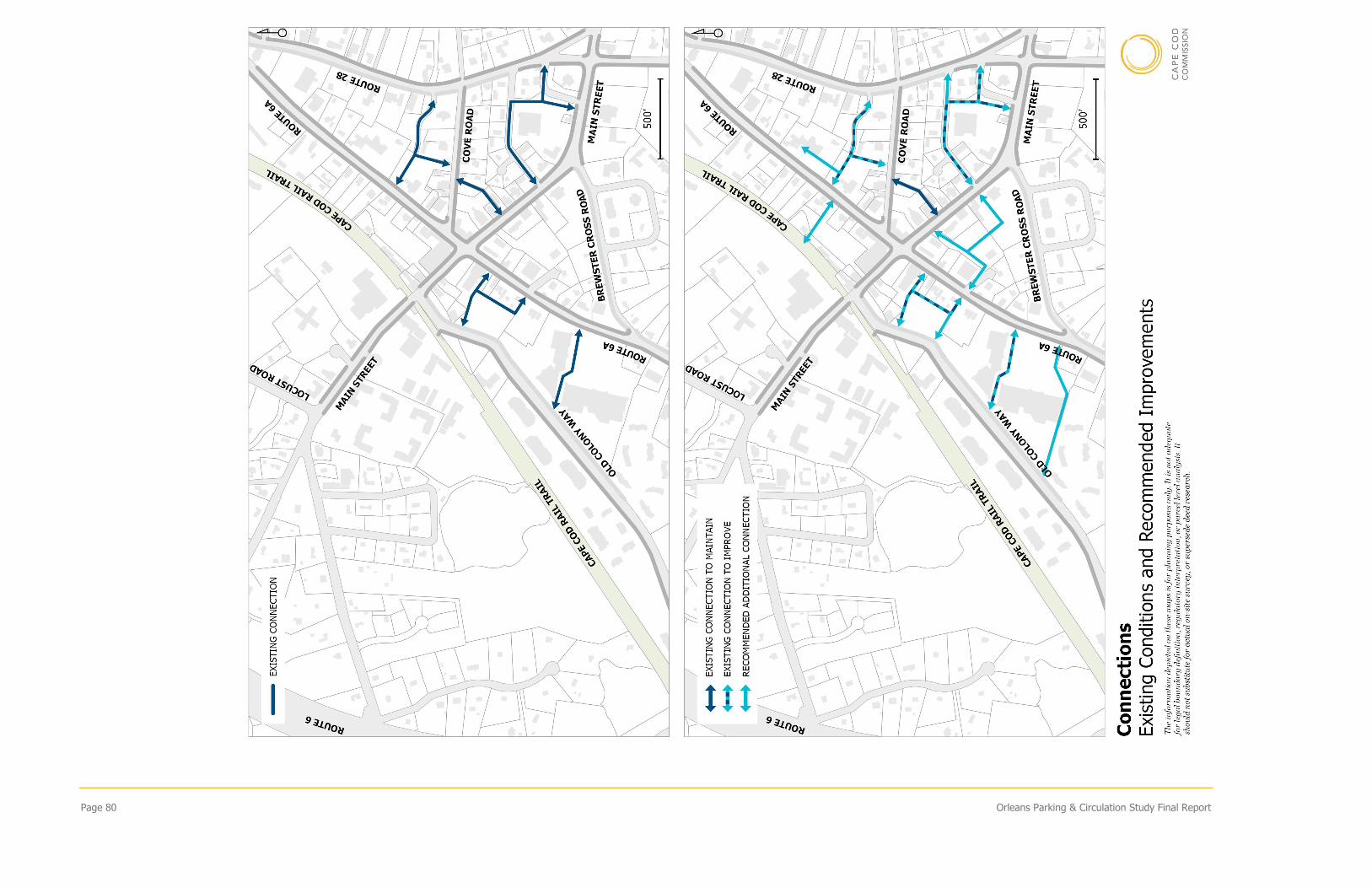
Page 80 Orleans Parking & Circulation Study Final Report
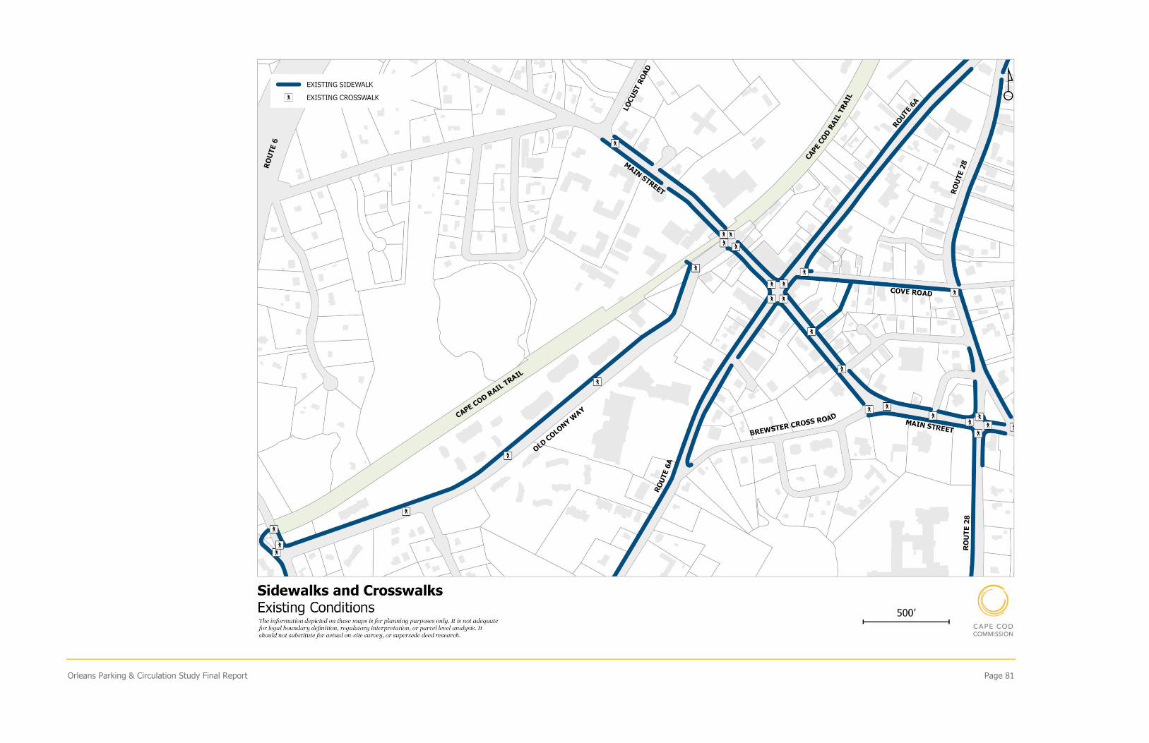
Orleans Parking & Circulation Study Final Report Page 81
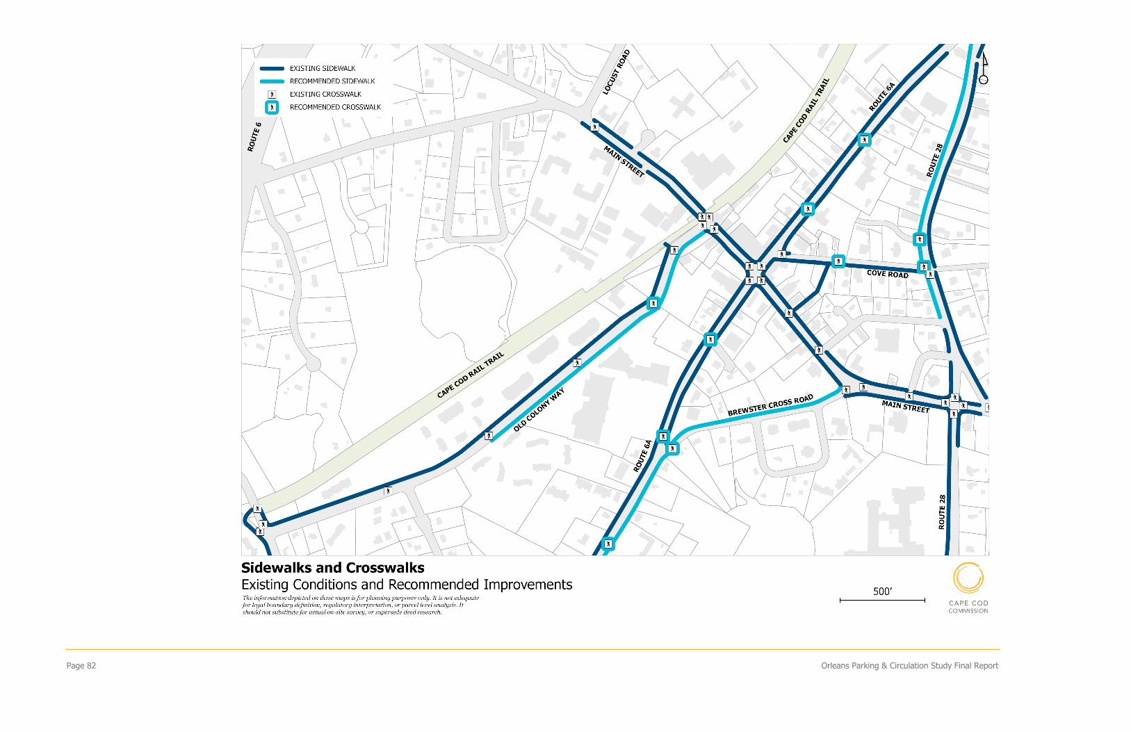
Page 82 Orleans Parking & Circulation Study Final Report
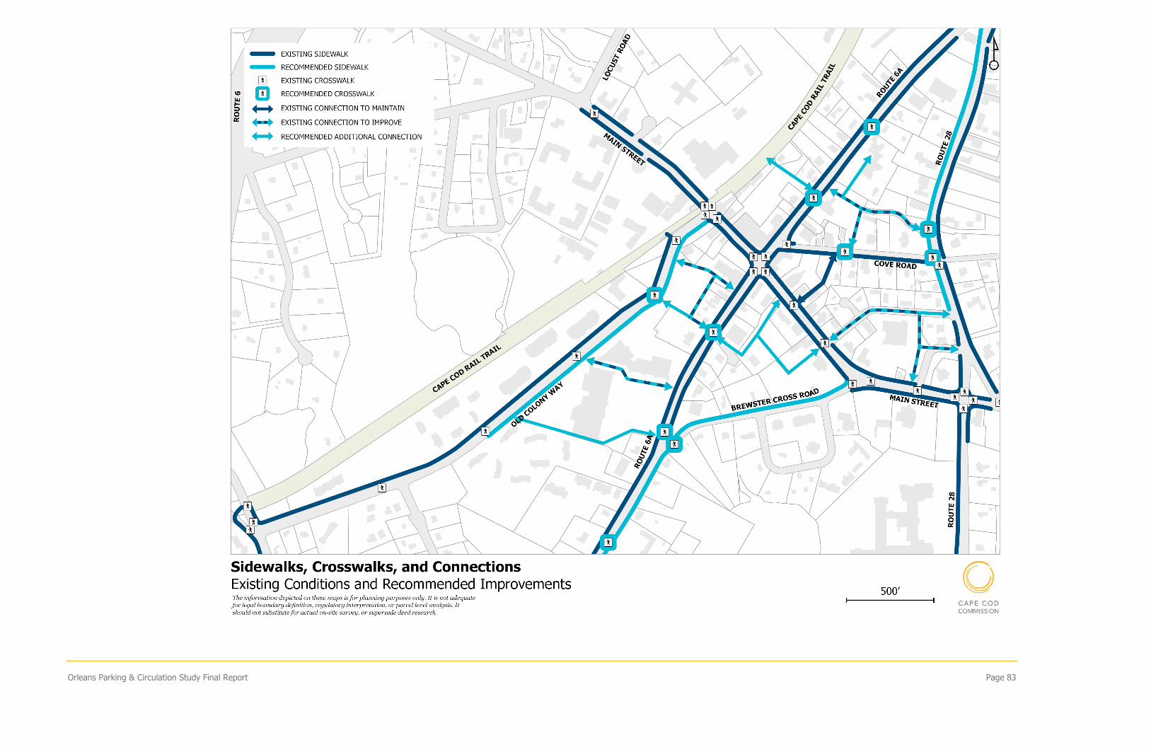
Orleans Parking & Circulation Study Final Report Page 83
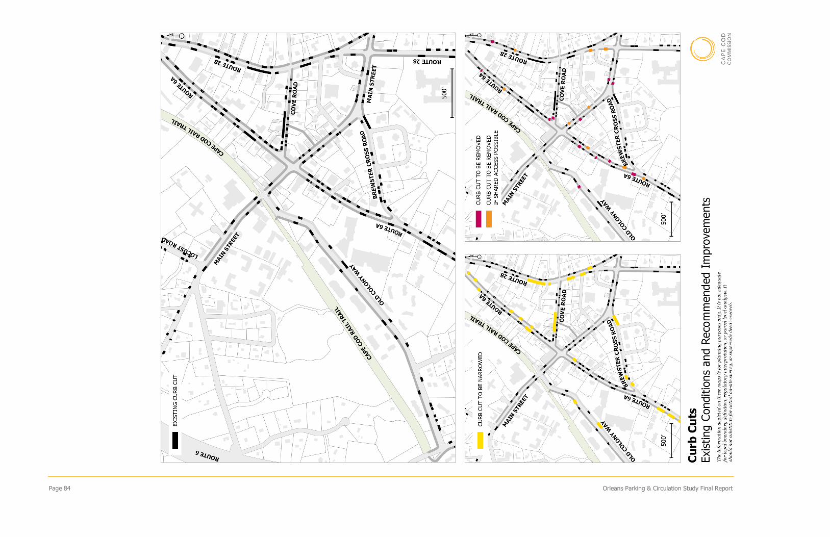
Page 84 Orleans Parking & Circulation Study Final Report