Embed Size (px)
Citation preview

Originally published 2015
March 2020: NESA Official Notice 9 March 2019 (NESA 7/20)
View the online version log for all syllabus updates.
© 2020 NSW Educational Standards Authority (NESA) for and on behalf of the Crown in right of the
State of New South Wales.
This document contains Material prepared by NESA for and on behalf of the Crown in right of the
State of New South Wales. The Material is protected by Crown copyright.
All rights reserved. No part of the Material may be reproduced in Australia or in any other country by
any process, electronic or otherwise, in any material form, or transmitted to any other person or stored
electronically in any form without the prior written permission of NESA, except as permitted by the
Copyright Act 1968.
When you access the Material you agree:
to use the Material for information purposes only
to reproduce a single copy for personal bona fide study use only and not to reproduce any major
extract or the entire Material without the prior permission of NESA
to acknowledge that the Material is provided by NESA
to include this copyright notice in any copy made
not to modify the Material or any part of the Material without the express prior written permission
of NESA.
The Material may contain third-party copyright materials such as photos, diagrams, quotations,
cartoons and artworks. These materials are protected by Australian and international copyright laws
and may not be reproduced or transmitted in any format without the copyright owner’s specific
permission. Unauthorised reproduction, transmission or commercial use of such copyright materials
may result in prosecution.
NESA has made all reasonable attempts to locate owners of third-party copyright material and invites
anyone from whom permission has not been sought to contact the Copyright Officer.
Phone: (02) 9367 8289
Fax: (02) 9279 1482
Email: [email protected]
Published by
NSW Education Standards Authority
GPO Box 5300
Sydney NSW 2001 Australia
www.educationstandards.nsw.edu.au
NCS-1544
D2017/111826
CONTENTS
Introduction.............................................................................................................................................. 3
Geography key ........................................................................................................................................ 6
Rationale ................................................................................................................................................. 9
The place of the Geography K–10 Syllabus in the K–12 curriculum .................................................... 10
Aim ........................................................................................................................................................ 11
Objectives.............................................................................................................................................. 12
Outcomes .............................................................................................................................................. 13
Stage Statements .................................................................................................................................. 15
Organisation of Content ........................................................................................................................ 18
Geographical concepts ......................................................................................................................... 19
Geographical inquiry skills .................................................................................................................... 25
Geographical tools ................................................................................................................................ 28
Content .................................................................................................................................................. 32
Content for Early Stage 1 ................................................................................................................... 38
Content for Stage 1 ............................................................................................................................ 42
Content for Stage 2 ............................................................................................................................ 48
Content for Stage 3 ............................................................................................................................ 54
Content for Stage 4 ............................................................................................................................ 60
Content for Stage 5 ............................................................................................................................ 72
Years 7–10 Life Skills outcomes and content ....................................................................................... 83
Years 7–10 Life Skills content ............................................................................................................ 88
Assessment ......................................................................................................................................... 106
Glossary .............................................................................................................................................. 109
Geography K–10 Syllabus (2015) 3
INTRODUCTION
K–10 CURRICULUM
The NSW Education Standards Authority (NESA) syllabuses have been developed with respect to
some overarching views about education. These include the NESA K–10 Curriculum Framework and
Statement of Equity Principles, and the Melbourne Declaration on Educational Goals for Young
Australians (December 2008).
NESA syllabuses include the agreed Australian Curriculum content and content that clarifies the
scope, breadth and depth of learning. The Australian Curriculum achievement standards underpin the
syllabus outcomes and the Stage statements for Early Stage 1 to Stage 5.
In accordance with the K–10 Curriculum Framework and the Statement of Equity Principles, the
syllabus takes into account the diverse needs of all students. It identifies essential knowledge,
understanding, skills, values and attitudes. It outlines clear standards of what students are expected
to know and be able to do in K–10. It provides structures and processes by which teachers can
provide continuity of study for all students.
The framework also provides a set of broad learning outcomes that summarise the knowledge,
understanding, skills, values and attitudes essential for all students in all learning areas to succeed in
and beyond their schooling.
The continued relevance of the K–10 Curriculum Framework is consistent with the intent of the
Melbourne Declaration on Educational Goals for Young Australians (December 2008), which sets the
direction for Australian schooling for the next ten years. There are two broad goals:
Goal 1: Australian schooling promotes equity and excellence
Goal 2: All young Australians become successful learners, confident and creative individuals,
and active and informed citizens.
The way in which learning in the Geography K–10 Syllabus will contribute to the curriculum and to
students’ achievement of the broad learning outcomes is outlined in the syllabus rationale.
DIVERSITY OF LEARNERS
NSW syllabuses are inclusive of the learning needs of all students. Syllabuses accommodate
teaching approaches that support student diversity, including students with disability, gifted and
talented students, and students learning English as an additional language or dialect (EAL/D).
Students may have more than one learning need.
STUDENTS WITH DISABILITY
All students are entitled to participate in and progress through the curriculum. Under the Disability
Standards for Education 2005, schools are required to provide additional support or adjustments to
teaching, learning and assessment activities for some students with disability. Adjustments are
measures or actions taken in relation to teaching, learning and assessment that enable a student with
disability to access syllabus outcomes and content and demonstrate achievement of outcomes.
Geography K–10 Syllabus (2015) 4
Students with disability can access outcomes and content from K–10 syllabuses in a range of ways.
Students may engage with:
syllabus outcomes and content from their age-appropriate Stage with adjustments to teaching,
learning and/or assessment activities; or
selected syllabus outcomes and content from their age-appropriate Stage, relevant to their
learning needs; or
syllabus outcomes from an earlier Stage, using age-appropriate content; or
selected Years 7–10 Life Skills outcomes and content from one or more syllabuses for students in
Stages 4 and 5.
Decisions regarding curriculum options, including adjustments, should be made in the context of
collaborative curriculum planning with the student, parent/carer and other significant individuals to
ensure that syllabus outcomes and content reflect the learning needs and priorities of individual
students.
Further information can be found on the NESA website in support materials for:
Human Society and its Environment (HSIE)
Special Education
Life Skills.
GIFTED AND TALENTED STUDENTS
Gifted and talented students have specific learning needs that may require adjustments to the pace,
level and content of the curriculum. Differentiated educational opportunities assist in meeting the
needs of gifted and talented students.
Generally, gifted and talented students demonstrate the following characteristics:
the capacity to learn at faster rates
the capacity to find and solve problems
the capacity to make connections and manipulate abstract ideas.
There are different kinds and levels of giftedness and talent. Gifted and talented students may also
have learning disabilities and/or English as an additional language or dialect. These needs should be
addressed when planning appropriate teaching, learning and assessment activities.
Curriculum strategies for gifted and talented students may include:
differentiation: modifying the pace, level and content of teaching, learning and assessment
activities
acceleration: promoting a student to a level of study beyond their age group
curriculum compacting: assessing a student’s current level of learning and addressing aspects of
the curriculum that have not yet been mastered.
School decisions about appropriate strategies are generally collaborative and involve teachers,
parents/carers and students, with reference to documents and advice available from NESA and the
education sectors.
Gifted and talented students may also benefit from individual planning to determine the curriculum
options, as well as teaching, learning and assessment strategies, most suited to their needs and
abilities.
Geography K–10 Syllabus (2015) 5
STUDENTS LEARNING ENGLISH AS AN ADDITIONAL LANGUAGE OR
DIALECT (EAL/D)
Many students in Australian schools are learning English as an additional language or dialect
(EAL/D). EAL/D students are those whose first language is a language or dialect other than Standard
Australian English and who require additional support to assist them to develop English language
proficiency.
EAL/D students come from diverse backgrounds and may include:
overseas and Australian-born students whose first language is a language other than English,
including creoles and related varieties
Aboriginal and Torres Strait Islander students whose first language is Aboriginal English, including
Kriol and related varieties.
EAL/D students enter Australian schools at different ages and stages of schooling and at different
stages of English language learning. They have diverse talents and capabilities and a range of prior
learning experiences and levels of literacy in their first language and in Standard Australian English.
EAL/D students represent a significant and growing percentage of learners in NSW schools. For
some, school is the only place they use Standard Australian English.
EAL/D students are simultaneously learning a new language and the knowledge, understanding and
skills of a syllabus through that new language. They require additional time and support, along with
informed teaching that explicitly addresses their language needs, and assessments that take into
account their developing language proficiency.
The ESL Scales and the English as an Additional Language or Dialect: Teacher Resource provide
information about the English language development phases of EAL/D students. These materials and
other resources can be used to support the specific needs of EAL/D students and to assist students to
access syllabus outcomes and content.
Geography K–10 Syllabus (2015) 6
GEOGRAPHY KEY
The following codes and icons are used in the Geography K–10 Syllabus.
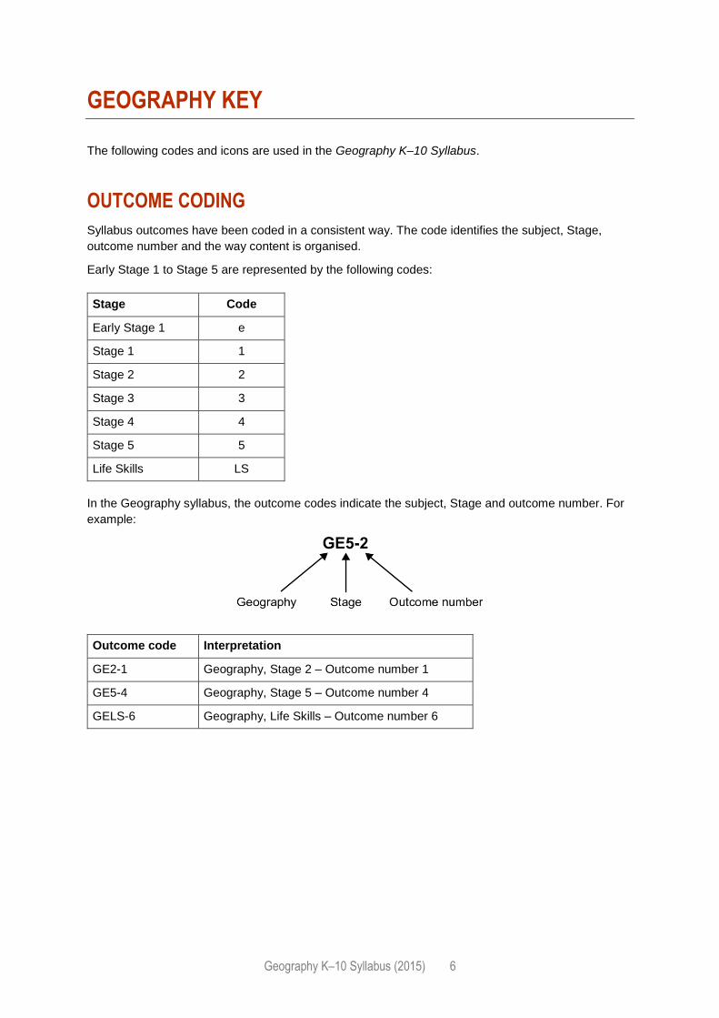
OUTCOME CODING
Syllabus outcomes have been coded in a consistent way. The code identifies the subject, Stage,
outcome number and the way content is organised.
Early Stage 1 to Stage 5 are represented by the following codes:
Stage Code
Early Stage 1 e
Stage 1 1
Stage 2 2
Stage 3 3
Stage 4 4
Stage 5 5
Life Skills LS
In the Geography syllabus, the outcome codes indicate the subject, Stage and outcome number. For
example:
Outcome code Interpretation
GE2-1 Geography, Stage 2 – Outcome number 1
GE5-4 Geography, Stage 5 – Outcome number 4
GELS-6 Geography, Life Skills – Outcome number 6
Geography K–10 Syllabus (2015) 7
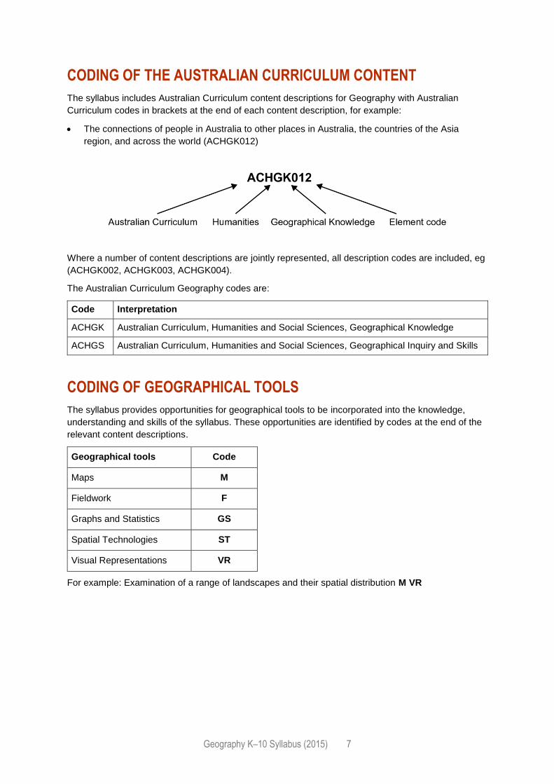
CODING OF THE AUSTRALIAN CURRICULUM CONTENT
The syllabus includes Australian Curriculum content descriptions for Geography with Australian
Curriculum codes in brackets at the end of each content description, for example:
The connections of people in Australia to other places in Australia, the countries of the Asia
region, and across the world (ACHGK012)
Where a number of content descriptions are jointly represented, all description codes are included, eg
(ACHGK002, ACHGK003, ACHGK004).
The Australian Curriculum Geography codes are:
Code Interpretation
ACHGK Australian Curriculum, Humanities and Social Sciences, Geographical Knowledge
ACHGS Australian Curriculum, Humanities and Social Sciences, Geographical Inquiry and Skills
CODING OF GEOGRAPHICAL TOOLS
The syllabus provides opportunities for geographical tools to be incorporated into the knowledge,
understanding and skills of the syllabus. These opportunities are identified by codes at the end of the
relevant content descriptions.
Geographical tools Code
Maps M
Fieldwork F
Graphs and Statistics GS
Spatial Technologies ST
Visual Representations VR
For example: Examination of a range of landscapes and their spatial distribution M VR
Geography K–10 Syllabus (2015) 8
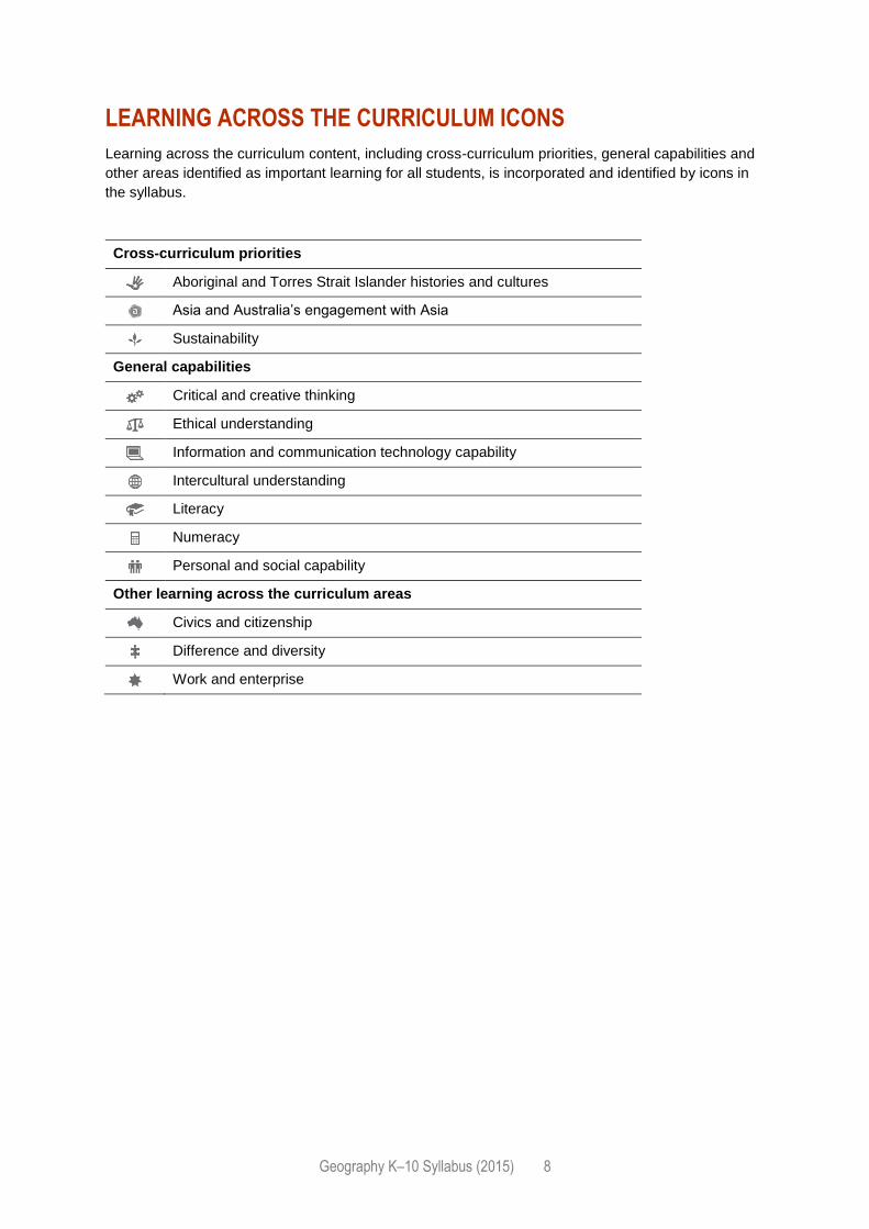
LEARNING ACROSS THE CURRICULUM ICONS
Learning across the curriculum content, including cross-curriculum priorities, general capabilities and
other areas identified as important learning for all students, is incorporated and identified by icons in
the syllabus.
Cross-curriculum priorities
Aboriginal and Torres Strait Islander histories and cultures
Asia and Australia’s engagement with Asia
Sustainability
General capabilities
Critical and creative thinking
Ethical understanding
Information and communication technology capability
Intercultural understanding
Literacy
Numeracy
Personal and social capability
Other learning across the curriculum areas
Civics and citizenship
Difference and diversity
Work and enterprise
Geography K–10 Syllabus (2015) 9
RATIONALE
Geography is the study of places and the relationships between people and their environments.
It is a rich and complex discipline that integrates knowledge from natural sciences, social sciences
and humanities to build a holistic understanding of the world. Through the study of Geography,
students are encouraged to question why the world is the way it is, reflect on their relationships
with and responsibilities for the world and propose actions designed to shape a socially just and
sustainable future.
Geography emphasises the role, function and importance of the environment in supporting human life
from local to global scales. It also emphasises the important interrelationships between people and
environments and the different understandings of these relationships. The wellbeing of societies and
environments depends on the quality of interactions between people and the natural world.
Geographical inquiry involves students acquiring, processing and communicating geographical
information. Through an inquiry approach students explain patterns, evaluate consequences and
contribute to the management of places and environments in an increasingly complex world. This
process enables them to apply inquiry skills including: asking distinctively geographical questions;
planning an inquiry and evaluating information; processing, analysing and interpreting that
information; reaching conclusions based on evidence and logical reasoning; evaluating and
communicating their findings; and reflecting on their inquiry and responding, through action, to what
they have learned. Engagement in fieldwork and the use of other tools including mapping and spatial
technologies are fundamental to geographical inquiry, including understanding and observing ethical
practices.
The study of Geography enables students to become informed, responsible and active citizens able to
evaluate the opinions of others and express their own ideas and arguments. This forms a basis for
active participation in community life, a commitment to sustainability, the creation of a just society,
and the promotion of intercultural understanding and lifelong learning. The skills and capabilities
developed through geographical study can be applied to further education, work and everyday life.
Geography K–10 Syllabus (2015) 10
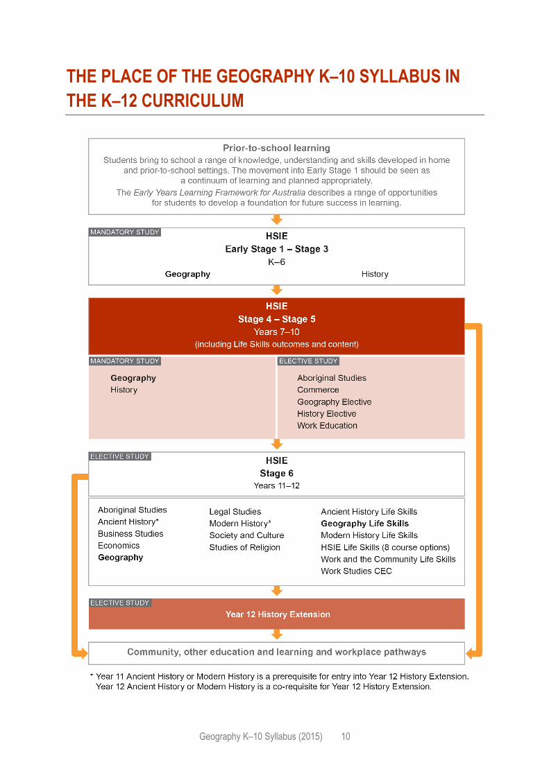
THE PLACE OF THE GEOGRAPHY K–10 SYLLABUS IN
THE K–12 CURRICULUM
Geography K–10 Syllabus (2015) 11
AIM
The aim of Geography in Years K–10 is to stimulate students’ interest in and engagement with the
world. Through geographical inquiry they develop an understanding of the interactions between
people, places and environments across a range of scales in order to become informed, responsible
and active citizens.
Geography K–10 Syllabus (2015) 12
OBJECTIVES
EARLY STAGE 1 – STAGE 5
KNOWLEDGE AND UNDERSTANDING
Students:
develop knowledge and understanding of the features and characteristics of places and
environments across a range of scales
develop knowledge and understanding of interactions between people, places and environments.
SKILLS
Students:
apply geographical tools for geographical inquiry
develop skills to acquire, process and communicate geographical information.
VALUES AND ATTITUDES
Students value and appreciate:
Geography as a study of interactions between people, places and environments
the dynamic nature of the world
the varying perspectives of people on geographical issues
the importance of sustainability and intercultural understanding
the role of being informed, responsible and active citizens.
Geography K–10 Syllabus (2015) 13
OUTCOMES
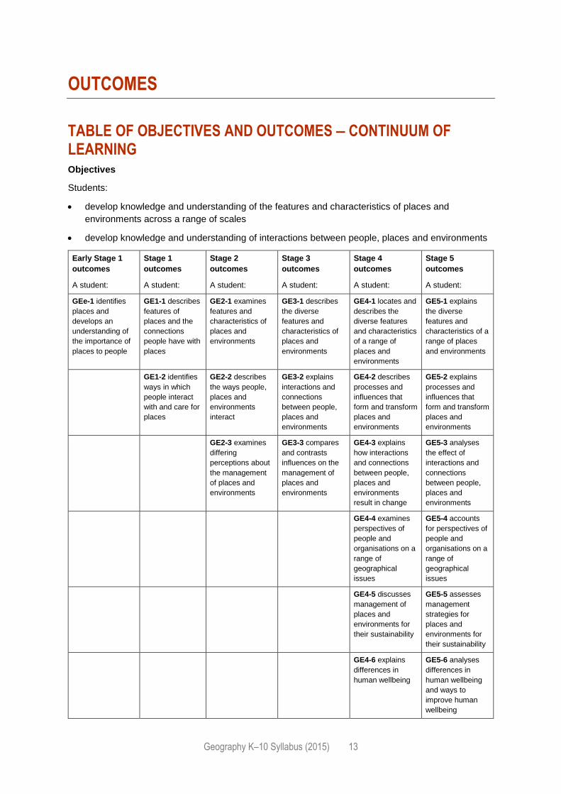
TABLE OF OBJECTIVES AND OUTCOMES – CONTINUUM OF LEARNING Objectives
Students:
develop knowledge and understanding of the features and characteristics of places and
environments across a range of scales
develop knowledge and understanding of interactions between people, places and environments
Early Stage 1
outcomes
A student:
Stage 1
outcomes
A student:
Stage 2
outcomes
A student:
Stage 3
outcomes
A student:
Stage 4
outcomes
A student:
Stage 5
outcomes
A student:
GEe-1 identifies
places and
develops an
understanding of
the importance of
places to people
GE1-1 describes
features of
places and the
connections
people have with
places
GE2-1 examines
features and
characteristics of
places and
environments
GE3-1 describes
the diverse
features and
characteristics of
places and
environments
GE4-1 locates and
describes the
diverse features
and characteristics
of a range of
places and
environments
GE5-1 explains
the diverse
features and
characteristics of a
range of places
and environments
GE1-2 identifies
ways in which
people interact
with and care for
places
GE2-2 describes
the ways people,
places and
environments
interact
GE3-2 explains
interactions and
connections
between people,
places and
environments
GE4-2 describes
processes and
influences that
form and transform
places and
environments
GE5-2 explains
processes and
influences that
form and transform
places and
environments
GE2-3 examines
differing
perceptions about
the management
of places and
environments
GE3-3 compares
and contrasts
influences on the
management of
places and
environments
GE4-3 explains
how interactions
and connections
between people,
places and
environments
result in change
GE5-3 analyses
the effect of
interactions and
connections
between people,
places and
environments
GE4-4 examines
perspectives of
people and
organisations on a
range of
geographical
issues
GE5-4 accounts
for perspectives of
people and
organisations on a
range of
geographical
issues
GE4-5 discusses
management of
places and
environments for
their sustainability
GE5-5 assesses
management
strategies for
places and
environments for
their sustainability
GE4-6 explains
differences in
human wellbeing
GE5-6 analyses
differences in
human wellbeing
and ways to
improve human
wellbeing
Geography K–10 Syllabus (2015) 14
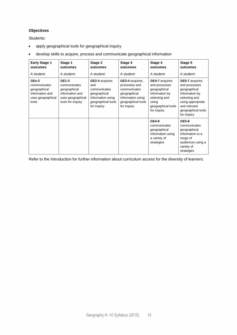
Objectives
Students:
apply geographical tools for geographical inquiry
develop skills to acquire, process and communicate geographical information
Early Stage 1
outcomes
A student:
Stage 1
outcomes
A student:
Stage 2
outcomes
A student:
Stage 3
outcomes
A student:
Stage 4
outcomes
A student:
Stage 5
outcomes
A student:
GEe-2
communicates
geographical
information and
uses geographical
tools
GE1-3
communicates
geographical
information and
uses geographical
tools for inquiry
GE2-4 acquires
and
communicates
geographical
information using
geographical tools
for inquiry
GE3-4 acquires,
processes and
communicates
geographical
information using
geographical tools
for inquiry
GE4-7 acquires
and processes
geographical
information by
selecting and
using
geographical tools
for inquiry
GE5-7 acquires
and processes
geographical
information by
selecting and
using appropriate
and relevant
geographical tools
for inquiry
GE4-8
communicates
geographical
information using
a variety of
strategies
GE5-8
communicates
geographical
information to a
range of
audiences using a
variety of
strategies
Refer to the Introduction for further information about curriculum access for the diversity of learners.
Geography K–10 Syllabus (2015) 15
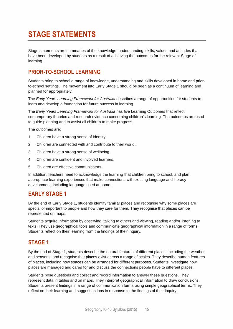
STAGE STATEMENTS
Stage statements are summaries of the knowledge, understanding, skills, values and attitudes that
have been developed by students as a result of achieving the outcomes for the relevant Stage of
learning.
PRIOR-TO-SCHOOL LEARNING
Students bring to school a range of knowledge, understanding and skills developed in home and prior-
to-school settings. The movement into Early Stage 1 should be seen as a continuum of learning and
planned for appropriately.
The Early Years Learning Framework for Australia describes a range of opportunities for students to
learn and develop a foundation for future success in learning.
The Early Years Learning Framework for Australia has five Learning Outcomes that reflect
contemporary theories and research evidence concerning children’s learning. The outcomes are used
to guide planning and to assist all children to make progress.
The outcomes are:
1 Children have a strong sense of identity.
2 Children are connected with and contribute to their world.
3 Children have a strong sense of wellbeing.
4 Children are confident and involved learners.
5 Children are effective communicators.
In addition, teachers need to acknowledge the learning that children bring to school, and plan
appropriate learning experiences that make connections with existing language and literacy
development, including language used at home.
EARLY STAGE 1
By the end of Early Stage 1, students identify familiar places and recognise why some places are
special or important to people and how they care for them. They recognise that places can be
represented on maps.
Students acquire information by observing, talking to others and viewing, reading and/or listening to
texts. They use geographical tools and communicate geographical information in a range of forms.
Students reflect on their learning from the findings of their inquiry.
STAGE 1
By the end of Stage 1, students describe the natural features of different places, including the weather
and seasons, and recognise that places exist across a range of scales. They describe human features
of places, including how spaces can be arranged for different purposes. Students investigate how
places are managed and cared for and discuss the connections people have to different places.
Students pose questions and collect and record information to answer these questions. They
represent data in tables and on maps. They interpret geographical information to draw conclusions.
Students present findings in a range of communication forms using simple geographical terms. They
reflect on their learning and suggest actions in response to the findings of their inquiry.
Geography K–10 Syllabus (2015) 16
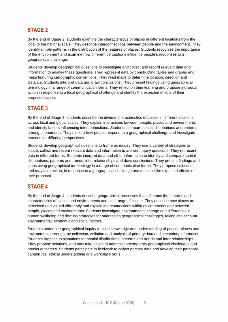
STAGE 2
By the end of Stage 2, students examine the characteristics of places in different locations from the
local to the national scale. They describe interconnections between people and the environment. They
identify simple patterns in the distribution of the features of places. Students recognise the importance
of the environment and examine how different perceptions influence people’s responses to a
geographical challenge.
Students develop geographical questions to investigate and collect and record relevant data and
information to answer these questions. They represent data by constructing tables and graphs and
maps featuring cartographic conventions. They read maps to determine location, direction and
distance. Students interpret data and draw conclusions. They present findings using geographical
terminology in a range of communication forms. They reflect on their learning and propose individual
action in response to a local geographical challenge and identify the expected effects of their
proposed action.
STAGE 3
By the end of Stage 3, students describe the diverse characteristics of places in different locations
across local and global scales. They explain interactions between people, places and environments
and identify factors influencing interconnections. Students compare spatial distributions and patterns
among phenomena. They explore how people respond to a geographical challenge and investigate
reasons for differing perspectives.
Students develop geographical questions to frame an inquiry. They use a variety of strategies to
locate, collect and record relevant data and information to answer inquiry questions. They represent
data in different forms. Students interpret data and other information to identify and compare spatial
distributions, patterns and trends, infer relationships and draw conclusions. They present findings and
ideas using geographical terminology in a range of communication forms. They propose solutions,
and may take action, in response to a geographical challenge and describe the expected effects of
their proposal.
STAGE 4
By the end of Stage 4, students describe geographical processes that influence the features and
characteristics of places and environments across a range of scales. They describe how places are
perceived and valued differently and explain interconnections within environments and between
people, places and environments. Students investigate environmental change and differences in
human wellbeing and discuss strategies for addressing geographical challenges, taking into account
environmental, economic and social factors.
Students undertake geographical inquiry to build knowledge and understanding of people, places and
environments through the collection, collation and analysis of primary data and secondary information.
Students propose explanations for spatial distributions, patterns and trends and infer relationships.
They propose solutions, and may take action to address contemporary geographical challenges and
predict outcomes. Students participate in fieldwork to collect primary data and develop their personal
capabilities, ethical understanding and workplace skills.
Geography K–10 Syllabus (2015) 17
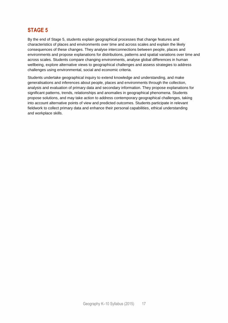
STAGE 5
By the end of Stage 5, students explain geographical processes that change features and
characteristics of places and environments over time and across scales and explain the likely
consequences of these changes. They analyse interconnections between people, places and
environments and propose explanations for distributions, patterns and spatial variations over time and
across scales. Students compare changing environments, analyse global differences in human
wellbeing, explore alternative views to geographical challenges and assess strategies to address
challenges using environmental, social and economic criteria.
Students undertake geographical inquiry to extend knowledge and understanding, and make
generalisations and inferences about people, places and environments through the collection,
analysis and evaluation of primary data and secondary information. They propose explanations for
significant patterns, trends, relationships and anomalies in geographical phenomena. Students
propose solutions, and may take action to address contemporary geographical challenges, taking
into account alternative points of view and predicted outcomes. Students participate in relevant
fieldwork to collect primary data and enhance their personal capabilities, ethical understanding
and workplace skills.
Geography K–10 Syllabus (2015) 18
CONTENT
For Kindergarten to Year 10, courses of study and educational programs are based on the outcomes
of syllabuses. The content describes in more detail how the outcomes are to be interpreted and used,
and the intended learning appropriate for the Stage. In considering the intended learning, teachers will
make decisions about the sequence, the emphasis to be given to particular areas of content, and any
adjustments required based on the needs, interests and abilities of their students.
The knowledge, understanding and skills described in the outcomes and content will provide a sound
basis for students to successfully move to the next Stage of learning.
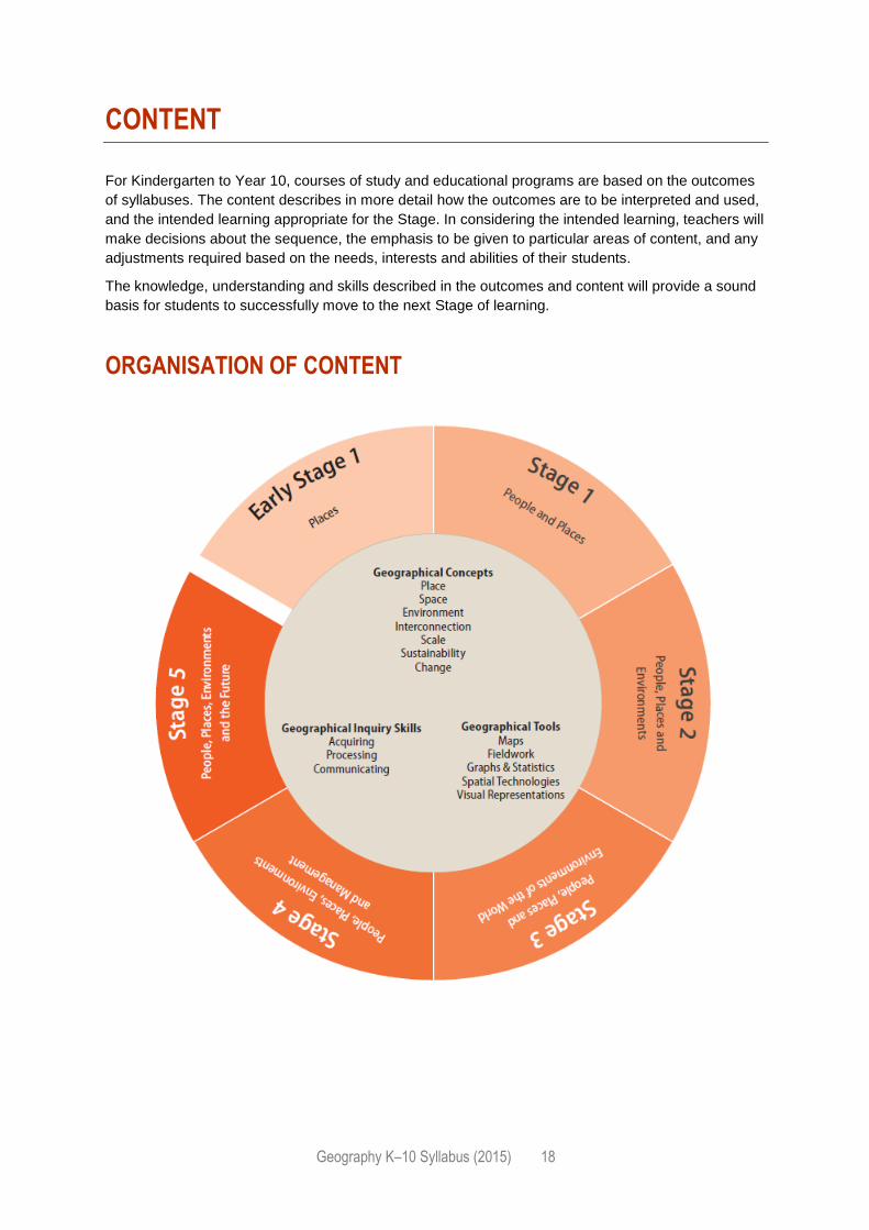
ORGANISATION OF CONTENT
Geography K–10 Syllabus (2015) 19
GEOGRAPHICAL CONCEPTS
The geographical concepts of place, space, environment, interconnection, scale, sustainability and
change are integral to the development of geographical understanding. They are ideas that can be
applied across the subject to identify a question or guide an investigation. They are the key ideas
involved in teaching students to think geographically.
The K–10 Geographical Concepts Continuum provides an overview of when each concept is
introduced to students and examples of how students’ understanding of concepts may be developed
across their Stages of learning.
PLACE
The concept of place is about the significance of places and what they are like.
An understanding of the concept of place may be developed in the following ways:
Places are parts of the Earth’s surface that are identified and given meaning by people. They may
be perceived, experienced, understood and valued differently. They range in size from a part of a
room or garden to a major world region. They can be described by their location, shape,
boundaries, features and environmental and human characteristics. Some characteristics are
tangible, for example, landforms and people, while others are intangible, for example, scenic
quality and culture.
Places are important to our security, identity and sense of belonging, and they provide us with the
services and facilities needed to support and enhance our lives. Where people live can influence
their wellbeing and opportunities.
The environmental characteristics of a place are influenced by human actions and the actions of
environmental processes over short to long time periods.
The human characteristics of a place are influenced by its environmental characteristics and
resources, relative location, connections with other places, the culture of its population, the
economy of a country, and the decisions and actions of people and organisations over time and at
different scales.
The places in which we live are created, changed and managed by people.
Each place is unique in its characteristics. As a consequence, the outcomes of similar
environmental and socioeconomic processes vary in different places, and similar problems may
require different strategies in different places.
The sustainability of places may be threatened by a range of factors, for example, natural
hazards; climate change; economic, social and technological change; government decisions;
conflict; exhaustion of a resource; and environmental degradation.
Geography K–10 Syllabus (2015) 20
SPACE
The concept of space is about the significance of location and spatial distribution, and ways people
organise and manage the spaces that we live in.
An understanding of the concept of space may be developed in the following ways:
The environmental and human characteristics of places are influenced by their location, but the
effects of location and distance from other places on people are being reduced, though unequally,
by improvements in transport and communication technologies.
The individual characteristics of places form spatial distributions, and the analysis of these
distributions contributes to geographical understanding. The distributions also have
environmental, economic, social and political consequences.
Spaces are perceived, structured, organised and managed by people, and can be designed and
redesigned to achieve particular purposes.
ENVIRONMENT
The concept of environment is about the significance of the environment in human life, and the
important interrelationships between humans and the environment.
An understanding of the concept of environment may be developed in the following ways:
The environment is the product of geological, atmospheric, hydrological, geomorphic, edaphic
(soil), biotic and human processes.
The environment supports and enriches human and other life by providing raw materials and food,
absorbing and recycling wastes, maintaining a safe habitat and being a source of enjoyment and
inspiration. It presents both opportunities for, and constraints on, human settlement and economic
development. The constraints can be reduced but not eliminated by technology and human
organisation.
Culture, population density, economy, technology, values and environmental worldviews influence
the different ways in which people perceive, adapt to and use similar environments.
Management of human-induced environmental change requires an understanding of the causes
and consequences of change, and involves the application of geographical concepts and
techniques to identify appropriate strategies.
Each type of environment has its specific hazards. The impact of these hazards on people is
determined by both natural and human factors, and can be managed but not eliminated by
prevention, mitigation and preparedness.
Geography K–10 Syllabus (2015) 21
INTERCONNECTION
The concept of interconnection emphasises that no object of geographical study can be viewed in
isolation.
An understanding of the concept of interconnection may be developed in the following ways:
People and organisations in places are interconnected with other places in a variety of ways.
These interconnections have significant influences on the characteristics of places and on
changes in these characteristics.
Environmental and human processes, for example, the water cycle, urbanisation or human-
induced environmental change, are sets of cause-and-effect interconnections that can operate
between and within places. They can sometimes be organised as systems involving networks of
interconnections through flows of matter, energy, information and actions.
SCALE
The concept of scale is about the way that geographical phenomena and problems can be examined
at different spatial levels.
An understanding of the concept of scale may be developed in the following ways:
Generalisations made and relationships found at one level of scale may be different at a higher or
lower level. For example, in studies of vegetation, climate is the main factor at the global scale but
soil and drainage may be the main factors at the local scale.
Cause-and-effect relationships cross scales from the local to the global and from the global to the
local. For example, local events can have global outcomes, such as the effects of local vegetation
removal on global climate.
SUSTAINABILITY
The concept of sustainability is about the capacity of the environment to continue to support our lives
and the lives of other living creatures into the future.
An understanding of the concept of sustainability may be developed in the following ways:
Sustainability is both a goal and a way of thinking about how to progress towards that goal.
Progress towards environmental sustainability depends on the maintenance or restoration of the
environmental functions that sustain all life and human wellbeing (economic and social).
An understanding of the causes of unsustainability requires a study of the environmental
processes producing the degradation of an environmental function; the human actions that have
initiated these processes; and the attitudinal, demographic, social, economic and political causes
of these human actions.
There are a variety of contested views on how progress towards sustainability should be achieved
and these are often informed by worldviews such as stewardship.
Geography K–10 Syllabus (2015) 22
CHANGE
The concept of change is about explaining geographical phenomena by investigating how they have
developed over time.
An understanding of the concept of change may be developed in the following ways:
Environmental change can occur over both short and long-term time frames, and both time scales
have interrelationships with human activities.
Environmental, economic, social and technological change is spatially uneven, and affects places
differently.
An understanding of the current processes of change can be used to predict change in the future
and to identify what would be needed to achieve preferred and more sustainable futures.
Geography K–10 Syllabus (2015) 23
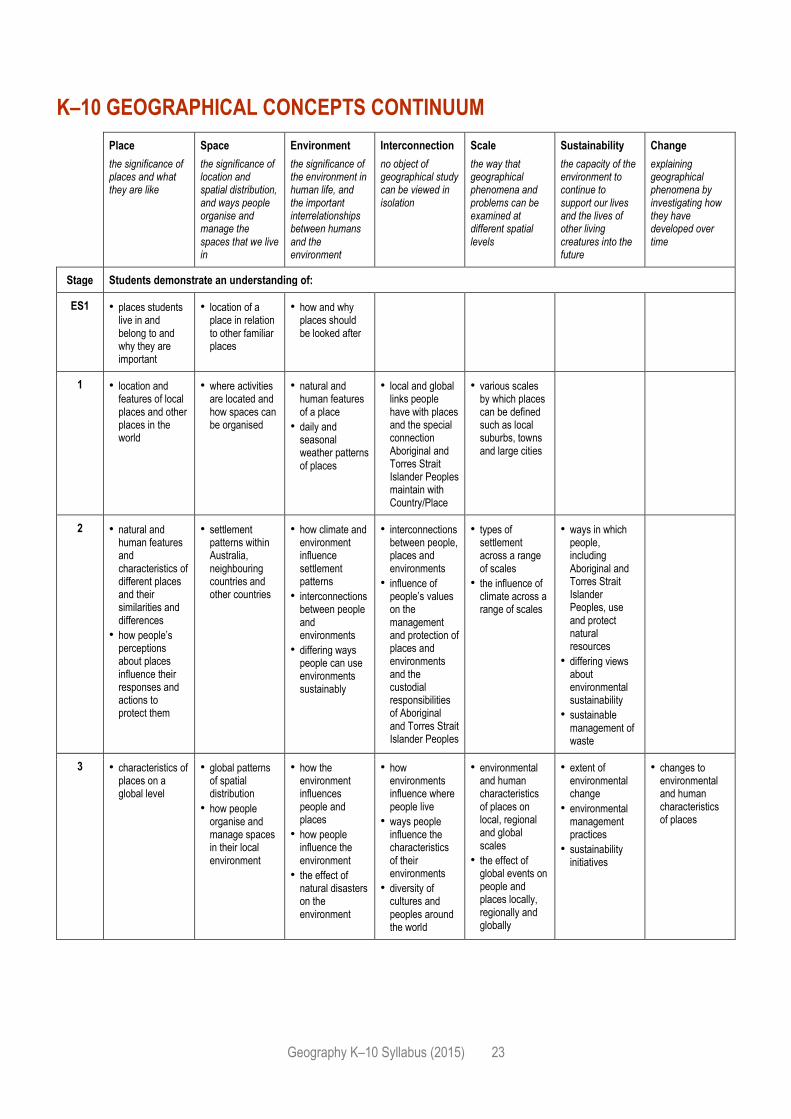
K–10 GEOGRAPHICAL CONCEPTS CONTINUUM
Place
the significance of places and what they are like
Space
the significance of location and spatial distribution, and ways people organise and manage the spaces that we live in
Environment
the significance of the environment in human life, and the important interrelationships between humans and the environment
Interconnection
no object of geographical study can be viewed in isolation
Scale
the way that geographical phenomena and problems can be examined at different spatial levels
Sustainability
the capacity of the environment to continue to support our lives and the lives of other living creatures into the future
Change
explaining geographical phenomena by investigating how they have developed over time
Stage Students demonstrate an understanding of:
ES1 • places students live in and belong to and why they are important
• location of a place in relation to other familiar places
• how and why places should be looked after
1 • location and features of local places and other places in the world
• where activities are located and how spaces can be organised
• natural and human features of a place
• daily and seasonal weather patterns of places
• local and global links people have with places and the special connection Aboriginal and Torres Strait Islander Peoples maintain with Country/Place
• various scales by which places can be defined such as local suburbs, towns and large cities
2 • natural and human features and characteristics of different places and their similarities and differences
• how people’s perceptions about places influence their responses and actions to protect them
• settlement patterns within Australia, neighbouring countries and other countries
• how climate and environment influence settlement patterns
• interconnections between people and environments
• differing ways people can use environments sustainably
• interconnections between people, places and environments
• influence of people’s values on the management and protection of places and environments and the custodial responsibilities of Aboriginal and Torres Strait Islander Peoples
• types of settlement across a range of scales
• the influence of climate across a range of scales
• ways in which people, including Aboriginal and Torres Strait Islander Peoples, use and protect natural resources
• differing views about environmental sustainability
• sustainable management of waste
3 • characteristics of places on a global level
• global patterns of spatial distribution
• how people organise and manage spaces in their local environment
• how the environment influences people and places
• how people influence the environment
• the effect of natural disasters on the environment
• how environments influence where people live
• ways people influence the characteristics of their environments
• diversity of cultures and peoples around the world
• environmental and human characteristics of places on local, regional and global scales
• the effect of global events on people and places locally, regionally and globally
• extent of environmental change
• environmental management practices
• sustainability initiatives
• changes to environmental and human characteristics of places
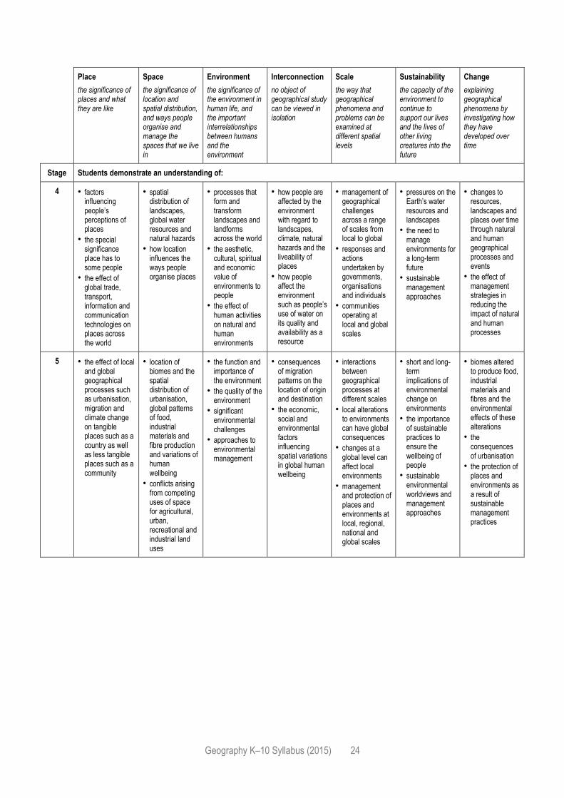
Geography K–10 Syllabus (2015) 24
Place
the significance of places and what they are like
Space
the significance of location and spatial distribution, and ways people organise and manage the spaces that we live in
Environment
the significance of the environment in human life, and the important interrelationships between humans and the environment
Interconnection
no object of geographical study can be viewed in isolation
Scale
the way that geographical phenomena and problems can be examined at different spatial levels
Sustainability
the capacity of the environment to continue to support our lives and the lives of other living creatures into the future
Change
explaining geographical phenomena by investigating how they have developed over time
Stage Students demonstrate an understanding of:
4 • factors influencing people’s perceptions of places
• the special significance place has to some people
• the effect of global trade, transport, information and communication technologies on places across the world
• spatial distribution of landscapes, global water resources and natural hazards
• how location influences the ways people organise places
• processes that form and transform landscapes and landforms across the world
• the aesthetic, cultural, spiritual and economic value of environments to people
• the effect of human activities on natural and human environments
• how people are affected by the environment with regard to landscapes, climate, natural hazards and the liveability of places
• how people affect the environment such as people’s use of water on its quality and availability as a resource
• management of geographical challenges across a range of scales from local to global
• responses and actions undertaken by governments, organisations and individuals
• communities operating at local and global scales
• pressures on the Earth’s water resources and landscapes
• the need to manage environments for a long-term future
• sustainable management approaches
• changes to resources, landscapes and places over time through natural and human geographical processes and events
• the effect of management strategies in reducing the impact of natural and human processes
5 • the effect of local and global geographical processes such as urbanisation, migration and climate change on tangible places such as a country as well as less tangible places such as a community
• location of biomes and the spatial distribution of urbanisation, global patterns of food, industrial materials and fibre production and variations of human wellbeing
• conflicts arising from competing uses of space for agricultural, urban, recreational and industrial land uses
• the function and importance of the environment
• the quality of the environment
• significant environmental challenges
• approaches to environmental management
• consequences of migration patterns on the location of origin and destination
• the economic, social and environmental factors influencing spatial variations in global human wellbeing
• interactions between geographical processes at different scales
• local alterations to environments can have global consequences
• changes at a global level can affect local environments
• management and protection of places and environments at local, regional, national and global scales
• short and long-term implications of environmental change on environments
• the importance of sustainable practices to ensure the wellbeing of people
• sustainable environmental worldviews and management approaches
• biomes altered to produce food, industrial materials and fibres and the environmental effects of these alterations
• the consequences of urbanisation
• the protection of places and environments as a result of sustainable management practices
Geography K–10 Syllabus (2015) 25
GEOGRAPHICAL INQUIRY SKILLS
Geographical inquiry is a process by which students learn about and deepen their understanding of
geography. It involves individual or collaborative investigations that start with geographical questions
and proceed through the collection, evaluation, interpretation and analysis of information to the
development of conclusions and proposals for actions. Students apply their geographical skills and
use geographical tools during an inquiry process to acquire, process and communicate geographical
information and form proposals, and where appropriate, act upon them. Inquiries may vary in scale
and geographical context. Fieldwork provides opportunities for students to be involved in an active
inquiry outside the classroom.
It is not intended that students would always undertake a complete inquiry process. For example,
teachers could provide students with data to represent or analyse rather than have students acquire
or collect the information themselves. Throughout the years of schooling, inquiry will progressively
move from more teacher-centred to more student-centred as students develop skills and experience
with inquiry processes.
The stages of a complete inquiry are:
Acquiring geographical information
identify an issue or problem
develop geographical questions to investigate the issue or problem
collect primary geographical data
gather geographical information from secondary sources
record information
Processing geographical information
evaluate data and information for reliability and bias
represent data and information in appropriate forms
interpret data and information gathered
analyse findings and results
draw conclusions
Communicating geographical information
communicate the results using a variety of strategies appropriate to the subject matter, purpose
and audience
reflect on the findings of the investigation; what has been learned; the process and effectiveness
of the inquiry
propose actions and predict outcomes
where appropriate, take action.
Geography K–10 Syllabus (2015) 26
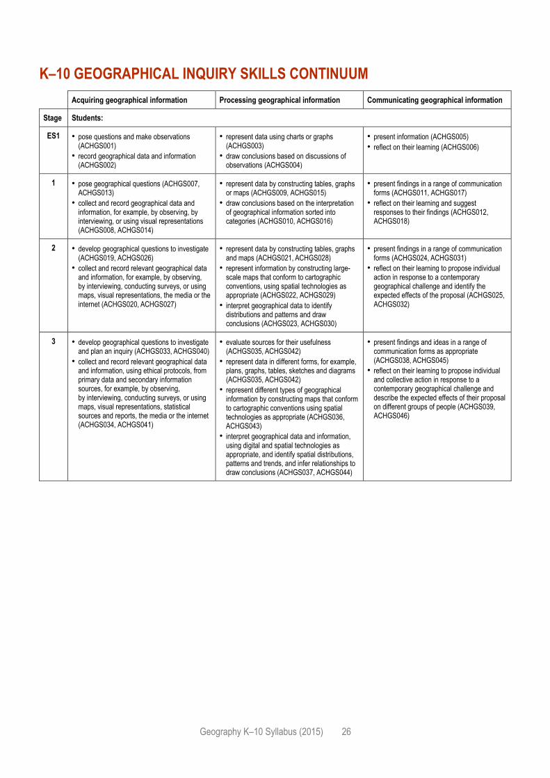
K–10 GEOGRAPHICAL INQUIRY SKILLS CONTINUUM
Acquiring geographical information Processing geographical information Communicating geographical information
Stage Students:
ES1 • pose questions and make observations (ACHGS001)
• record geographical data and information (ACHGS002)
• represent data using charts or graphs (ACHGS003)
• draw conclusions based on discussions of observations (ACHGS004)
• present information (ACHGS005)
• reflect on their learning (ACHGS006)
1 • pose geographical questions (ACHGS007, ACHGS013)
• collect and record geographical data and information, for example, by observing, by interviewing, or using visual representations (ACHGS008, ACHGS014)
• represent data by constructing tables, graphs or maps (ACHGS009, ACHGS015)
• draw conclusions based on the interpretation of geographical information sorted into categories (ACHGS010, ACHGS016)
• present findings in a range of communication forms (ACHGS011, ACHGS017)
• reflect on their learning and suggest responses to their findings (ACHGS012, ACHGS018)
2 • develop geographical questions to investigate (ACHGS019, ACHGS026)
• collect and record relevant geographical data and information, for example, by observing, by interviewing, conducting surveys, or using maps, visual representations, the media or the internet (ACHGS020, ACHGS027)
• represent data by constructing tables, graphs and maps (ACHGS021, ACHGS028)
• represent information by constructing large-scale maps that conform to cartographic conventions, using spatial technologies as appropriate (ACHGS022, ACHGS029)
• interpret geographical data to identify distributions and patterns and draw conclusions (ACHGS023, ACHGS030)
• present findings in a range of communication forms (ACHGS024, ACHGS031)
• reflect on their learning to propose individual action in response to a contemporary geographical challenge and identify the expected effects of the proposal (ACHGS025, ACHGS032)
3 • develop geographical questions to investigate and plan an inquiry (ACHGS033, ACHGS040)
• collect and record relevant geographical data and information, using ethical protocols, from primary data and secondary information sources, for example, by observing, by interviewing, conducting surveys, or using maps, visual representations, statistical sources and reports, the media or the internet (ACHGS034, ACHGS041)
• evaluate sources for their usefulness (ACHGS035, ACHGS042)
• represent data in different forms, for example, plans, graphs, tables, sketches and diagrams (ACHGS035, ACHGS042)
• represent different types of geographical information by constructing maps that conform to cartographic conventions using spatial technologies as appropriate (ACHGS036, ACHGS043)
• interpret geographical data and information, using digital and spatial technologies as appropriate, and identify spatial distributions, patterns and trends, and infer relationships to draw conclusions (ACHGS037, ACHGS044)
• present findings and ideas in a range of communication forms as appropriate (ACHGS038, ACHGS045)
• reflect on their learning to propose individual and collective action in response to a contemporary geographical challenge and describe the expected effects of their proposal on different groups of people (ACHGS039, ACHGS046)
Geography K–10 Syllabus (2015) 27
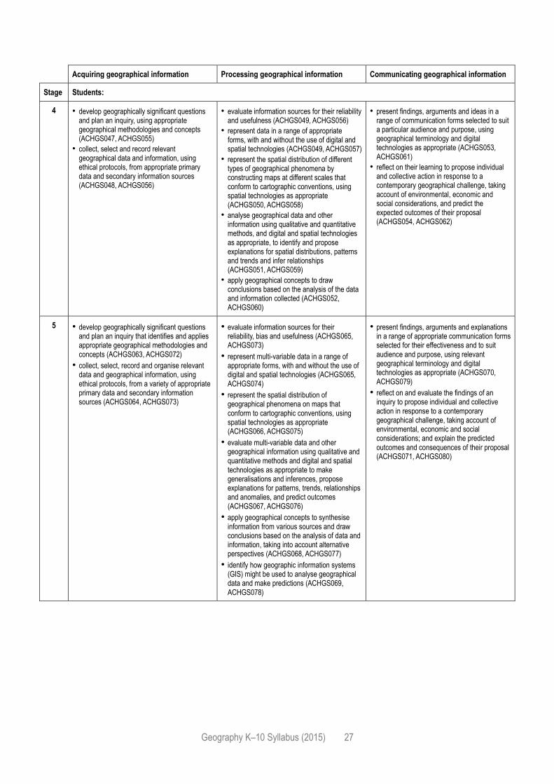
Acquiring geographical information Processing geographical information Communicating geographical information
Stage Students:
4 • develop geographically significant questions and plan an inquiry, using appropriate geographical methodologies and concepts (ACHGS047, ACHGS055)
• collect, select and record relevant geographical data and information, using ethical protocols, from appropriate primary data and secondary information sources (ACHGS048, ACHGS056)
• evaluate information sources for their reliability and usefulness (ACHGS049, ACHGS056)
• represent data in a range of appropriate forms, with and without the use of digital and spatial technologies (ACHGS049, ACHGS057)
• represent the spatial distribution of different types of geographical phenomena by constructing maps at different scales that conform to cartographic conventions, using spatial technologies as appropriate (ACHGS050, ACHGS058)
• analyse geographical data and other information using qualitative and quantitative methods, and digital and spatial technologies as appropriate, to identify and propose explanations for spatial distributions, patterns and trends and infer relationships (ACHGS051, ACHGS059)
• apply geographical concepts to draw conclusions based on the analysis of the data and information collected (ACHGS052, ACHGS060)
• present findings, arguments and ideas in a range of communication forms selected to suit a particular audience and purpose, using geographical terminology and digital technologies as appropriate (ACHGS053, ACHGS061)
• reflect on their learning to propose individual and collective action in response to a contemporary geographical challenge, taking account of environmental, economic and social considerations, and predict the expected outcomes of their proposal (ACHGS054, ACHGS062)
5 • develop geographically significant questions and plan an inquiry that identifies and applies appropriate geographical methodologies and concepts (ACHGS063, ACHGS072)
• collect, select, record and organise relevant data and geographical information, using ethical protocols, from a variety of appropriate primary data and secondary information sources (ACHGS064, ACHGS073)
• evaluate information sources for their reliability, bias and usefulness (ACHGS065, ACHGS073)
• represent multi-variable data in a range of appropriate forms, with and without the use of digital and spatial technologies (ACHGS065, ACHGS074)
• represent the spatial distribution of geographical phenomena on maps that conform to cartographic conventions, using spatial technologies as appropriate (ACHGS066, ACHGS075)
• evaluate multi-variable data and other geographical information using qualitative and quantitative methods and digital and spatial technologies as appropriate to make generalisations and inferences, propose explanations for patterns, trends, relationships and anomalies, and predict outcomes (ACHGS067, ACHGS076)
• apply geographical concepts to synthesise information from various sources and draw conclusions based on the analysis of data and information, taking into account alternative perspectives (ACHGS068, ACHGS077)
• identify how geographic information systems (GIS) might be used to analyse geographical data and make predictions (ACHGS069, ACHGS078)
• present findings, arguments and explanations in a range of appropriate communication forms selected for their effectiveness and to suit audience and purpose, using relevant geographical terminology and digital technologies as appropriate (ACHGS070, ACHGS079)
• reflect on and evaluate the findings of an inquiry to propose individual and collective action in response to a contemporary geographical challenge, taking account of environmental, economic and social considerations; and explain the predicted outcomes and consequences of their proposal (ACHGS071, ACHGS080)
Geography K–10 Syllabus (2015) 28
GEOGRAPHICAL TOOLS
Geographical tools are used by geographers during an inquiry to acquire, process and communicate
geographical information.
Students are to be provided with opportunities to engage with each of the geographical tools during
each Stage of learning. Teachers will make decisions about the specific geographical tools
appropriate to support the intended learning for the Stage. Some students with disability may require
adjustments to access the selected geographical tool.
The K–10 Geographical Tools Continuum provides examples of tools students may use in each Stage
of learning.
It is intended that students progressively move from using tools to interpret geographical data and
information in the earlier Stages of learning, to being able to develop and create tools for representing,
synthesising and communicating the findings of geographical inquiry.
MAPS – M
Maps take many forms and include digital and non-digital mediums. Examples include, but are not
limited to, pictorial maps, large-scale and small-scale maps, relief maps, choropleth maps, flowline
maps, cadastral maps, isoline maps, land use maps, physical maps, political maps, précis maps,
cultural mapping, road maps, thematic maps, tactile maps, topographic maps and special-purpose
maps. Maps are used to locate, visualise, represent, display and record spatial data.
FIELDWORK – F
Fieldwork is an integral and mandatory part of the study of Geography as it facilitates an
understanding of geographical processes and geographical inquiry. Fieldwork can enhance learning
opportunities for all students because it caters for a variety of teaching and learning approaches. The
enjoyable experience of active engagement in fieldwork helps to create and nurture a lifelong interest
in and enthusiasm for the world students live in.
Fieldwork involves observing, measuring, collecting and recording information outside the classroom.
Fieldwork can be undertaken within the school grounds, around local neighbouring areas or at more
distant locations. In some instances, it may be necessary to use information and communication
technology to undertake virtual fieldwork.
When conducting fieldwork, there are ethical issues to consider such as impacts on environments,
implications for plants and animals, or intellectual property where fieldwork involves people. If the
fieldwork is proposed for Aboriginal sites or about Aboriginal Peoples, Indigenous cultural and
intellectual property is an ethical consideration.
In those cases, participants should be familiar with a range of cultural protocols for working with
Aboriginal communities and ensure appropriate consultation with local communities and education
consultation occurs. (Further information on these protocols can be found in Working with Aboriginal
Communities: A Guide to Community Consultation and Protocols on the NESA website.)
Geography K–10 Syllabus (2015) 29
Fieldwork enables students to:
acquire knowledge about environments by observing, mapping, measuring and recording
phenomena in the real world in a variety of places, including the school
explore geographical processes that form and transform environments
use a range of geographical tools to assist in the interpretation of, and decision-making about,
geographical phenomena
locate, select, organise and communicate geographical information
explore different perspectives on geographical issues.
Fieldwork activities should be carefully planned to achieve syllabus outcomes. Fieldwork activities
should be integrated with the teaching and learning program to take full advantage of the enhanced
understanding that can be achieved through direct observation, field measurements and inquiry
learning. Fieldwork activities may be specific to a topic or may be integrated across the Geography
curriculum.
Students must undertake and participate in fieldwork in each Stage of learning. In the early years of
learning students should be guided to observe their local area such as weather and vegetation or
interviewing family and community members about connections to other places. Some students with
disability may require adjustments and/or additional support in order to engage in fieldwork.
There will be an increasing emphasis on independent observation and analysis of data in Stages 4–5.
There are many opportunities for fieldwork in Stages 4–5 such as investigating geomorphic processes
that create local landscapes, investigating the characteristics of a local place or observing aspects of
human-induced environmental changes that challenge sustainability in local or regional landscapes.
GRAPHS AND STATISTICS – GS
Graphs, also called charts, take many forms and include digital and non-digital mediums. Examples
include, but are not limited to, tally charts, pictographs, column graphs, line graphs, pie graphs,
weather charts, climate graphs and population profiles.
Statistics also take many forms and include digital and non-digital mediums. Students will begin with
basic data tables and progress to complex representations of statistics on common themes.
Graphs and statistics are used to collate, organise, illustrate, summarise and compare patterns,
relationships and trends in geographical data and information.
SPATIAL TECHNOLOGIES – ST
Spatial technologies include any software or hardware that interacts with real world locations.
Examples include, but are not limited to, virtual maps, satellite images, global positioning systems
(GPS), geographic information systems (GIS), remote sensing and augmented reality. Spatial
technologies are used to visualise, manipulate, analyse, display and record spatial data.
VISUAL REPRESENTATIONS – VR
Visual representations take many forms and include digital and non-digital mediums. Examples
include, but are not limited to, diagrams, images, photographs, paintings, illustrations, symbols,
models, posters, collages, cartoons, multimedia, infographics and mind maps. Visual representations
are used to display, visualise, analyse and communicate geographical data and information.
Geography K–10 Syllabus (2015) 30
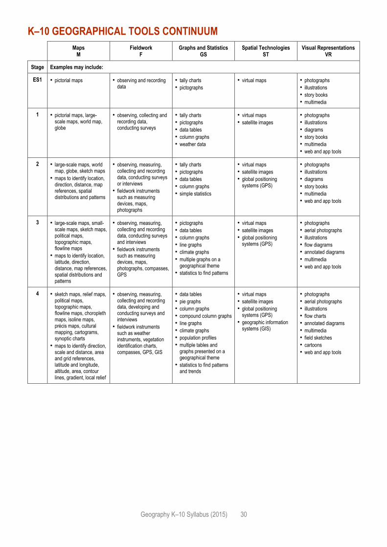
K–10 GEOGRAPHICAL TOOLS CONTINUUM
Maps M
Fieldwork F
Graphs and Statistics GS
Spatial Technologies ST
Visual Representations VR
Stage Examples may include:
ES1 • pictorial maps • observing and recording data
• tally charts
• pictographs
• virtual maps • photographs
• illustrations
• story books
• multimedia
1 • pictorial maps, large-scale maps, world map, globe
• observing, collecting and recording data, conducting surveys
• tally charts
• pictographs
• data tables
• column graphs
• weather data
• virtual maps
• satellite images
• photographs
• illustrations
• diagrams
• story books
• multimedia
• web and app tools
2 • large-scale maps, world map, globe, sketch maps
• maps to identify location, direction, distance, map references, spatial distributions and patterns
• observing, measuring, collecting and recording data, conducting surveys or interviews
• fieldwork instruments such as measuring devices, maps, photographs
• tally charts
• pictographs
• data tables
• column graphs
• simple statistics
• virtual maps
• satellite images
• global positioning systems (GPS)
• photographs
• illustrations
• diagrams
• story books
• multimedia
• web and app tools
3 • large-scale maps, small-scale maps, sketch maps, political maps, topographic maps, flowline maps
• maps to identify location, latitude, direction, distance, map references, spatial distributions and patterns
• observing, measuring, collecting and recording data, conducting surveys and interviews
• fieldwork instruments such as measuring devices, maps, photographs, compasses, GPS
• pictographs
• data tables
• column graphs
• line graphs
• climate graphs
• multiple graphs on a geographical theme
• statistics to find patterns
• virtual maps
• satellite images
• global positioning systems (GPS)
• photographs
• aerial photographs
• illustrations
• flow diagrams
• annotated diagrams
• multimedia
• web and app tools
4 • sketch maps, relief maps, political maps, topographic maps, flowline maps, choropleth maps, isoline maps, précis maps, cultural mapping, cartograms, synoptic charts
• maps to identify direction, scale and distance, area and grid references, latitude and longitude, altitude, area, contour lines, gradient, local relief
• observing, measuring, collecting and recording data, developing and conducting surveys and interviews
• fieldwork instruments such as weather instruments, vegetation identification charts, compasses, GPS, GIS
• data tables
• pie graphs
• column graphs
• compound column graphs
• line graphs
• climate graphs
• population profiles
• multiple tables and graphs presented on a geographical theme
• statistics to find patterns and trends
• virtual maps
• satellite images
• global positioning systems (GPS)
• geographic information systems (GIS)
• photographs
• aerial photographs
• illustrations
• flow charts
• annotated diagrams
• multimedia
• field sketches
• cartoons
• web and app tools
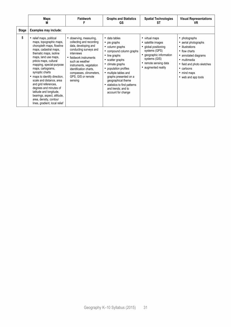
Geography K–10 Syllabus (2015) 31
Maps M
Fieldwork F
Graphs and Statistics GS
Spatial Technologies ST
Visual Representations VR
Stage Examples may include:
5 • relief maps, political maps, topographic maps, choropleth maps, flowline maps, cadastral maps, thematic maps, isoline maps, land use maps, précis maps, cultural mapping, special-purpose maps, cartograms, synoptic charts
• maps to identify direction, scale and distance, area and grid references, degrees and minutes of latitude and longitude, bearings, aspect, altitude, area, density, contour lines, gradient, local relief
• observing, measuring, collecting and recording data, developing and conducting surveys and interviews
• fieldwork instruments such as weather instruments, vegetation identification charts, compasses, clinometers, GPS, GIS or remote sensing
• data tables
• pie graphs
• column graphs
• compound column graphs
• line graphs
• scatter graphs
• climate graphs
• population profiles
• multiple tables and graphs presented on a geographical theme
• statistics to find patterns and trends; and to account for change
• virtual maps
• satellite images
• global positioning systems (GPS)
• geographic information systems (GIS)
• remote sensing data
• augmented reality
• photographs
• aerial photographs
• illustrations
• flow charts
• annotated diagrams
• multimedia
• field and photo sketches
• cartoons
• mind maps
• web and app tools
Geography K–10 Syllabus (2015) 32
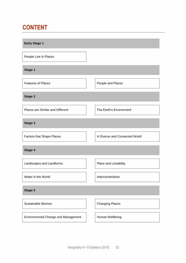
CONTENT
Early Stage 1
People Live in Places
Stage 1
Features of Places People and Places
Stage 2
Places are Similar and Different The Earth’s Environment
Stage 3
Factors that Shape Places A Diverse and Connected World
Stage 4
Landscapes and Landforms Place and Liveability
Water in the World Interconnections
Stage 5
Sustainable Biomes Changing Places
Environmental Change and Management Human Wellbeing
Geography K–10 Syllabus (2015) 33
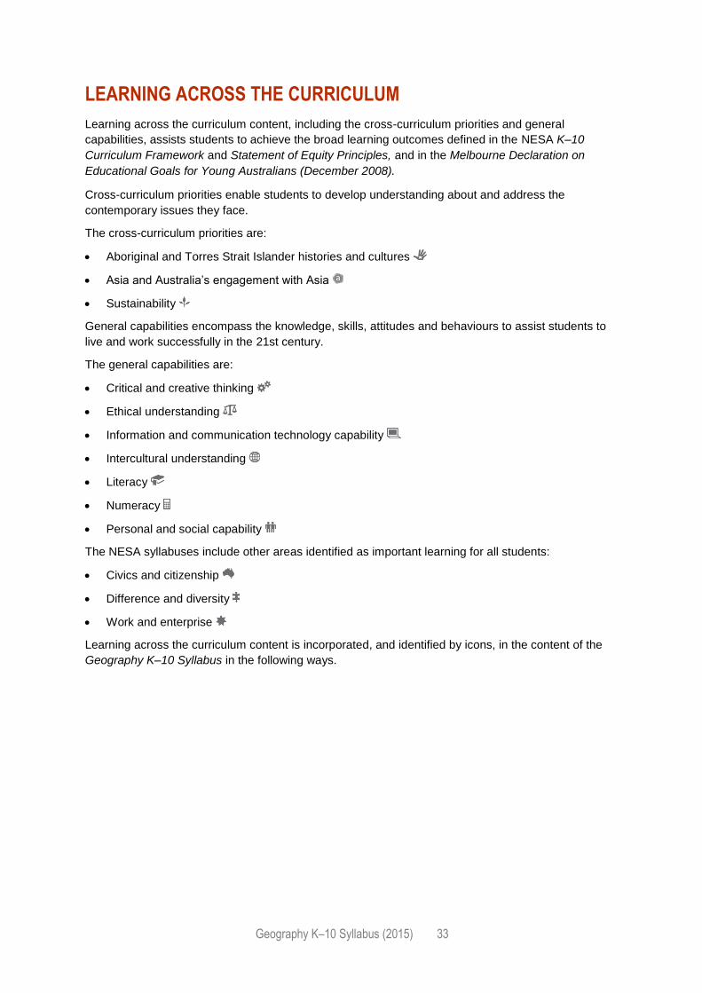
LEARNING ACROSS THE CURRICULUM
Learning across the curriculum content, including the cross-curriculum priorities and general
capabilities, assists students to achieve the broad learning outcomes defined in the NESA K–10
Curriculum Framework and Statement of Equity Principles, and in the Melbourne Declaration on
Educational Goals for Young Australians (December 2008).
Cross-curriculum priorities enable students to develop understanding about and address the
contemporary issues they face.
The cross-curriculum priorities are:
Aboriginal and Torres Strait Islander histories and cultures
Asia and Australia’s engagement with Asia
Sustainability
General capabilities encompass the knowledge, skills, attitudes and behaviours to assist students to
live and work successfully in the 21st century.
The general capabilities are:
Critical and creative thinking
Ethical understanding
Information and communication technology capability
Intercultural understanding
Literacy
Numeracy
Personal and social capability
The NESA syllabuses include other areas identified as important learning for all students:
Civics and citizenship
Difference and diversity
Work and enterprise
Learning across the curriculum content is incorporated, and identified by icons, in the content of the
Geography K–10 Syllabus in the following ways.
Geography K–10 Syllabus (2015) 34
Aboriginal and Torres Strait Islander histories and cultures
The study of Geography provides valuable opportunities for students to understand that contemporary
Aboriginal and Torres Strait Islander communities are strong, resilient, rich and diverse. It emphasises
the relationships people have with places and their interconnections with the environments in which
they live. The study of Geography integrates Aboriginal and Torres Strait Islander Peoples’ use of the
land, governed by a holistic, spiritually based connection to Country and Place, with the continuing
influence of Aboriginal and Torres Strait Islander Peoples on places, including in environmental
management and local and regional economies. Students learn that there are different ways of
thinking about and interacting with the environment and how this can influence sustainable
development. Geography provides opportunities for students to explore how the practices of
Aboriginal Peoples, as the oldest, continuous cultures in the world, support the sustainable use of
environments.
When planning and programming content relating to Aboriginal and Torres Strait Islander histories
and cultures, teachers are encouraged to:
involve local Aboriginal communities and/or appropriate knowledge holders in determining suitable
resources, or to use Aboriginal or Torres Strait Islander authored or endorsed publications
read the Principles and Protocols relating to teaching and learning about Aboriginal and Torres
Strait Islander histories and cultures and the involvement of local Aboriginal communities.
Asia and Australia’s engagement with Asia
Students learn about and recognise the diversity within and between the countries of the Asia region
and how this diversity influences the way people perceive and interact with places and environments.
Through the study of Geography, students have opportunities to develop knowledge and
understanding of Asian societies, cultures, beliefs and environments, and the connections between
the peoples of Asia, Australia, and the rest of the world. Throughout the study of Geography, students
are provided with rich contexts to investigate the interrelationships between diverse places,
environments and peoples in the Asia region, and are provided with opportunities to recognise Asia as
an important region of the world.
Sustainability
The study of Geography provides students with opportunities to develop the knowledge,
understanding, skills, values and attitudes necessary for them to act in ways that contribute to more
sustainable ways of living. Students have opportunities to develop an understanding that sustainability
is focused on environmental protection to create a more ecologically and socially just world and that
sustainable living requires environmental, social, cultural and economic considerations, and informed
action.
In Geography, students examine the effects of human challenges to sustainability, and strategies to
address these. Students evaluate the effects of strategies on environments, economies and societies,
and recognise that they can contribute to actions that support more sustainable ways of living.
Critical and creative thinking
In Geography, students are provided with opportunities to develop critical and creative thinking as
they investigate geographical information, concepts and ideas through inquiry-based learning. They
develop and practise critical and creative thinking by using strategies that help them think logically
when evaluating and using evidence, testing explanations, analysing arguments and making
decisions, and when thinking deeply about questions that do not have straightforward answers.
Students develop an understanding of the value and process of developing creative questions and the
importance of speculation. Students are encouraged to be curious and imaginative in investigations
and fieldwork and to think creatively about the ways that the places and spaces they use might be
better designed, and about possible, probable and preferable futures.
Geography K–10 Syllabus (2015) 35
Ethical understanding
Geography provides students with opportunities to develop ethical understanding as they identify and
investigate the nature of ethical concepts, values, character traits and principles, and how reasoning
can assist ethical judgement. Ethical understanding involves students in building a strong personal
and socially oriented ethical outlook that helps them to manage context, conflict and uncertainty, and
to develop an awareness of the influence that their values and behaviour have on others.
Geography supports students to develop their own ethical understanding as they investigate current
geographical issues and evaluate their findings against the criteria of environmental protection,
economic prosperity and social advancement. These criteria raise ethical questions that students
explore to develop informed values and attitudes and become aware of their own roles and
responsibilities as citizens.
When undertaking fieldwork, students have opportunities to learn about ethical procedures for
investigating and working with people and places. When thinking about the environment, students
consider their responsibilities to protect other forms of life that share the environment.
Information and communication technology capability
Students develop information and communication technology (ICT) capability by maximising use of
the technologies available to them, adapting as technologies evolve and limiting the risks to
themselves and others in a digital environment. Geography provides students with opportunities to
locate, select, evaluate, communicate and share geographical information using digital and spatial
technologies. They explore the effects of technologies on places, on the location of economic
activities and on people’s lives and develop an understanding of the geographical changes produced
by the increasing use of technology.
Intercultural understanding
The study of Geography provides students with opportunities to develop their intercultural
understanding as they learn to value their own cultures, languages and beliefs, and those of others.
They come to understand how personal, group and national identities are shaped, and the variable
and changing nature of culture. Intercultural understanding involves students learning about and
engaging with diverse cultures in ways that recognise similarities and differences, create connections
with others and cultivate mutual respect.
Students are provided with opportunities to learn about the diversity of the world’s peoples, places and
environments. As they investigate the interconnection between people and places and the meaning
and significance that places hold, they come to appreciate how various cultural identities are shaped.
Through opportunities to study the lives, cultures, values and beliefs of people in different places,
students learn to appreciate and interpret different perspectives and to challenge stereotypical or
prejudiced representations of social and cultural groups where they exist. Through studying people in
diverse places, they are provided with opportunities to recognise their similarities with other people,
better understand their differences, and demonstrate respect for cultural diversity and the human
rights of all people in local, national, regional and global settings.
Geography K–10 Syllabus (2015) 36
Literacy
The study of Geography provides students with opportunities to develop literacy capability as they
explore, discuss, analyse and communicate geographical information, concepts and ideas. They use
a wide range of informational and literary texts, for example interviews, reports, stories, photographs
and maps, to help them understand the people, places and environments that make up the world.
They learn to evaluate texts and recognise how language and images can be used to make and
manipulate meaning.
Students are provided with opportunities to develop literacy skills as they use language to pose
distinctively geographical questions. They plan a geographical inquiry, acquire and process
information, communicate their findings, reflect on their inquiry and respond to what they have
learned. Students progressively learn to use Geography’s scientific and expressive modes of writing
and the vocabulary of the discipline. They are provided with opportunities to comprehend and
compose graphical and visual texts through working with maps, visual representations and remotely
sensed and satellite images.
Numeracy
Students have opportunities in Geography to develop numeracy capability as they investigate
concepts fundamental to Geography, including the effects of location and distance, spatial
distributions and the organisation and management of space within places. They apply numeracy
skills in geographical analysis by counting and measuring, constructing and interpreting tables and
graphs, calculating and interpreting statistics and using statistical analysis to test relationships
between variables. In constructing and interpreting maps, students work with numerical concepts of
scale, distance and area.
Personal and social capability
In studying Geography, students are provided with opportunities to develop personal and social
capability as they engage in geographical inquiry, and develop an understanding of how geographical
knowledge informs their personal identity, sense of belonging and capacity to empathise with others,
as well as offering opportunities for contributing to their communities.
Inquiry-based learning in Geography provides opportunities for students to develop their capacity
for self-management. It gives them a role in directing their own learning and in planning and carrying
out investigations. It provides opportunities to express and reflect on their opinions, beliefs, values
and questions appropriately. This enables them to become independent learners who can apply
geographical understanding and skills to decisions they will have to make in the future. Through
working collaboratively in the classroom and in the field, students are encouraged to develop their
interpersonal and social skills, and to appreciate the different insights and perspectives of other
group members.
Geography K–10 Syllabus (2015) 37
Civics and citizenship
As students engage in learning in Geography, they have opportunities to develop the knowledge,
understanding, skills, values and attitudes for responsible, informed and active participation in
Australian society and as global citizens. Students explore ways they can shape their lives, value their
belonging in a diverse and dynamic society, and positively contribute at a range of scales. Active
citizens support democratic participation, foster individual and group involvement in civil society,
critically question existing political institutions and social, economic and political arrangements, and
facilitate democratic change.
Students are provided with opportunities to participate in decision-making and to exercise critical
judgement about political issues. Comparisons with other civil societies encourage students to
develop their understanding of the nature of democracy in Australia and in other countries. Students
examine the role of citizens in the context of government systems and institutions as well as political
and social life in Australia and other countries.
Difference and diversity
Difference and diversity comprises gender, ethnicity, ability and socioeconomic circumstances.
Geography is well placed to develop students’ knowledge and understanding of the difference and
diversity among people within and between communities. They are provided with opportunities to
identify and empathise with the varying perspectives of individuals and groups and attempt to
understand the actions, values, attitudes and motives of people. Students are encouraged to value
difference and to challenge social injustice that is caused by attitudes to difference. Students are
encouraged to investigate how diversity contributes to a sense of community and identity, including
national identity.
Work and enterprise
Geography provides students with opportunities to develop knowledge and understanding of
employment as a factor contributing to patterns of internal and international migration. Students
also recognise the role of employment in human wellbeing and development. Students explore
the impact on people, places and the environment of business activities, including trade connections
on local and global scales, the effect of production and consumption on the environment, and
sustainable business practices. Students are also provided with opportunities to learn how
organisations in Australia and overseas have a role in community action, such as environmental
protection and conflict over land use.
Geography K–10 Syllabus (2015) 38
CONTENT FOR EARLY STAGE 1
OVERVIEW OF TEACHING AND LEARNING
In considering the intended learning, teachers will make decisions about the sequence, the emphasis
to be given to particular areas of content, and any adjustments required based on the needs, interests
and abilities of their students. Content including knowledge and understanding, concepts, skills and
tools should be integrated to provide meaningful learning experiences for students.
Where appropriate, students are to be provided with opportunities to investigate a wide range of
places and environments from local to global scales.
THE FOLLOWING GEOGRAPHICAL CONCEPTS ARE TO BE INTEGRATED
THROUGHOUT EARLY STAGE 1:
Place: the significance of places and what they are like eg places students live in and belong to
and why they are important.
Space: the significance of location and spatial distribution, and ways people organise and
manage the spaces that we live in eg location of a place in relation to other familiar places.
Environment: the significance of the environment in human life, and the important
interrelationships between humans and the environment eg how and why places should be looked
after.
THE FOLLOWING GEOGRAPHICAL INQUIRY SKILLS ARE TO BE
INTEGRATED THROUGHOUT EARLY STAGE 1:
Acquiring geographical information
pose questions and make observations (ACHGS001)
record geographical data and information (ACHGS002)
Processing geographical information
represent data using charts or graphs (ACHGS003)
draw conclusions based on discussions of observations (ACHGS004)
Communicating geographical information
present information (ACHGS005)
reflect on their learning (ACHGS006)
Geography K–10 Syllabus (2015) 39
THE FOLLOWING GEOGRAPHICAL TOOLS ARE TO BE INTEGRATED
THROUGHOUT EARLY STAGE 1:
Examples may include:
Maps – M
pictorial maps
Fieldwork – F
observing and recording data
Graphs and statistics – GS
tally charts, pictographs
Spatial technologies – ST
virtual maps
Visual representations – VR
photographs, illustrations, story books, multimedia
Geography K–10 Syllabus (2015) 40
PEOPLE LIVE IN PLACES
OUTCOMES
A student:
› identifies places and develops an understanding of the importance of places to people GEe-1
› communicates geographical information and uses geographical tools GEe-2
KEY INQUIRY QUESTIONS
What are places like?
What makes a place special?
How can we look after the places we live in?
CONTENT FOCUS
Students explore the places they live in and belong to. They develop an understanding of what makes
a place special and how this may differ for different people. Students learn about the importance of
looking after places. Students explore how the location of places can be represented.
CONTENT
Important places
Students:
investigate the importance of places they live in and belong to, for example: (ACHGK002,
ACHGK004)
- identification of places they live in and belong to GS VR
- discussion of why places are special and how people care for them F
- explanation of why people need to take care of places
Aboriginal and Torres Strait Islander places
Students:
investigate the Countries/Places important to Aboriginal or Torres Strait Islander Peoples, for
example: (ACHGK003)
- identification of an Aboriginal or Torres Strait Islander site, Country or Place
- discussion of why the site, Country or Place is important

Geography K–10 Syllabus (2015) 41
Locating places
Students:
investigate how the location of places can be represented, for example: (ACHGK001)
- location of familiar and local places on maps M ST
- description of the location of places
Geography K–10 Syllabus (2015) 42
CONTENT FOR STAGE 1
OVERVIEW OF TEACHING AND LEARNING
In considering the intended learning, teachers will make decisions about the sequence, the emphasis
to be given to particular areas of content, and any adjustments required based on the needs, interests
and abilities of their students. Content including knowledge and understanding, concepts, skills and
tools should be integrated to provide meaningful learning experiences for students.
Where appropriate, students are to be provided with opportunities to investigate a wide range of
places and environments from local to global scales.
THE FOLLOWING GEOGRAPHICAL CONCEPTS ARE TO BE
INTEGRATED THROUGHOUT STAGE 1:
Place: the significance of places and what they are like eg location and features of local places
and other places in the world.
Space: the significance of location and spatial distribution, and ways people organise and
manage the spaces that we live in eg where activities are located and how spaces can be
organised.
Environment: the significance of the environment in human life, and the important
interrelationships between humans and the environment eg natural and human features of a
place; daily and seasonal weather patterns of places.
Interconnection: no object of geographical study can be viewed in isolation eg local and global
links people have with places and the special connection Aboriginal and Torres Strait Islander
Peoples maintain with Country/Place.
Scale: the way that geographical phenomena and problems can be examined at different spatial
levels eg various scales by which places can be defined such as local suburbs, towns and large
cities.
THE FOLLOWING GEOGRAPHICAL INQUIRY SKILLS ARE TO BE
INTEGRATED THROUGHOUT STAGE 1: Acquiring geographical information
pose geographical questions (ACHGS007, ACHGS013)
collect and record geographical data and information, for example, by observing, by interviewing,
or using visual representations (ACHGS008, ACHGS014)
Processing geographical information
represent data by constructing tables, graphs or maps (ACHGS009, ACHGS015)
draw conclusions based on the interpretation of geographical information sorted into categories
(ACHGS010, ACHGS016)
Geography K–10 Syllabus (2015) 43
Communicating geographical information
present findings in a range of communication forms (ACHGS011, ACHGS017)
reflect on their learning and suggest responses to their findings (ACHGS012, ACHGS018)
THE FOLLOWING GEOGRAPHICAL TOOLS ARE TO BE
INTEGRATED THROUGHOUT STAGE 1:
Examples may include:
Maps – M
pictorial maps, large-scale maps, world map, globe
Fieldwork – F
observing, collecting and recording data, conducting surveys
Graphs and statistics – GS
tally charts, pictographs, data tables, column graphs, weather data
Spatial technologies – ST
virtual maps, satellite images
Visual representations – VR
photographs, illustrations, diagrams, story books, multimedia, web and app tools
Geography K–10 Syllabus (2015) 44
FEATURES OF PLACES
OUTCOMES
A student:
› describes features of places and the connections people have with places GE1-1
› identifies ways in which people interact with and care for places GE1-2
› communicates geographical information and uses geographical tools for inquiry GE1-3
KEY INQUIRY QUESTIONS
What are the features of, and activities in, places?
How can we care for places?
How can spaces within a place be used for different purposes?
CONTENT FOCUS
Students investigate the natural and human features of places. They describe the reasons places
change and identify the active role of citizens in the care of places. They learn about how people
describe the weather and seasons of places. Students explore activities occurring in places and how
the spaces within places can be used for different purposes.
CONTENT
Features of places
Students:
investigate features of places and how they can be cared for, for example: (ACHGK005)
- description of the natural and human features of places ST VR
- discussion of the natural features of places identified in Aboriginal Dreaming stories and/or
creation accounts of the Torres Strait
- consideration of how a place can be cared for eg a park, farm, beach, bushland
Weather and seasons
Students:
investigate the weather and seasons of places, for example: (ACHGK006)
- description of the daily and seasonal weather patterns of a familiar place
- comparison of the daily and seasonal weather patterns of places GS
- examination of how various cultural groups, including Aboriginal or Torres Strait Islander
Peoples, describe weather, seasons or seasonal calendars VR
- discussion of how weather can affect places and activities eg leisure, farming

Geography K–10 Syllabus (2015) 45
How places are organised
Students:
investigate activities that occur within places, for example: (ACHGK007, ACHGK008)
- discussion of why and how the spaces within places can be rearranged for different purposes
eg street fair, school hall VR
- examination of why various activities in an area are located where they are eg school, shops
M F
Geography K–10 Syllabus (2015) 46
PEOPLE AND PLACES
OUTCOMES
A student:
› describes features of places and the connections people have with places GE1-1
› communicates geographical information and uses geographical tools for inquiry GE1-3
KEY INQUIRY QUESTIONS
Where are places located in Australia?
How are people connected to places?
What factors affect people’s connections to places?
CONTENT FOCUS Students explore places across a range of scales within Australia and Australia’s location in the world.
They describe connections people, including Aboriginal and Torres Strait Islander Peoples, have with
places, both locally and globally. Students identify factors affecting people’s accessibility to places.
CONTENT
Australian places
Students:
investigate places across a range of scales within Australia, for example: (ACHGK010)
- identification that places exist across a range of scales eg personal, local, national M VR
Australia’s location
Students:
investigate Australia’s location in the world, for example: (ACHGK009)
- description of Australia’s location in relation to the world eg continents, oceans M
People’s connections to places
Students:
investigate people’s connections and access to places, for example: (ACHGK013)
- discussion of why people visit other places GS
- identification of factors influencing people’s accessibility to places eg distance M
- examination of how technology has improved people’s access to places
Geography K–10 Syllabus (2015) 47
Local and global connections
Students:
investigate connections that people, including Aboriginal and Torres Strait Islander Peoples, have
to local and global places, for example: (ACHGK010, ACHGK011, ACHGK012)
- discussion of Aboriginal and Torres Strait Islander Peoples’ connections with land, sea and
animals of their place
- description of reasons people are connected to places in Australia and/or countries across the
world eg birthplace M
Geography K–10 Syllabus (2015) 48
CONTENT FOR STAGE 2
OVERVIEW OF TEACHING AND LEARNING
In considering the intended learning, teachers will make decisions about the sequence, the emphasis
to be given to particular areas of content, and any adjustments required based on the needs, interests
and abilities of their students. Content including knowledge and understanding, concepts, skills and
tools should be integrated to provide meaningful learning experiences for students.
Where appropriate, students are to be provided with opportunities to investigate a wide range of
places and environments from local to global scales.
THE FOLLOWING GEOGRAPHICAL CONCEPTS ARE TO BE
INTEGRATED THROUGHOUT STAGE 2:
Place: the significance of places and what they are like eg natural and human features and
characteristics of different places and their similarities and differences; how people’s perceptions
about places influence their responses and actions to protect them.
Space: the significance of location and spatial distribution, and ways people organise and
manage the spaces that we live in eg settlement patterns within Australia, neighbouring countries
and other countries.
Environment: the significance of the environment in human life, and the important
interrelationships between humans and the environment eg how climate and environment
influence settlement patterns; interconnections between people and environments; differing ways
people can use environments sustainably.
Interconnection: no object of geographical study can be viewed in isolation eg interconnections
between people, places and environments; influence of people’s values on the management and
protection of places and environments and the custodial responsibilities of Aboriginal and Torres
Strait Islander Peoples.
Scale: the way that geographical phenomena and problems can be examined at different spatial
levels eg types of settlement across a range of scales; the influence of climate across a range of
scales.
Sustainability: the capacity of the environment to continue to support our lives and the lives of
other living creatures into the future eg ways in which people, including Aboriginal and Torres
Strait Islander Peoples, use and protect natural resources; differing views about environmental
sustainability; sustainable management of waste.
THE FOLLOWING GEOGRAPHICAL INQUIRY SKILLS ARE TO BE
INTEGRATED THROUGHOUT STAGE 2:
Acquiring geographical information
develop geographical questions to investigate (ACHGS019, ACHGS026)
collect and record relevant geographical data and information, for example, by observing,
by interviewing, conducting surveys, or using maps, visual representations, the media or the
internet (ACHGS020, ACHGS027)
Geography K–10 Syllabus (2015) 49
Processing geographical information
represent data by constructing tables, graphs and maps (ACHGS021, ACHGS028)
represent information by constructing large-scale maps that conform to cartographic conventions,
using spatial technologies as appropriate (ACHGS022, ACHGS029)
interpret geographical data to identify distributions and patterns and draw conclusions
(ACHGS023, ACHGS030)
Communicating geographical information
present findings in a range of communication forms, for example, written, oral, digital, graphic,
tabular and visual, and use geographical terminology (ACHGS024, ACHGS031)
reflect on their learning to propose individual action in response to a contemporary geographical
challenge and identify the expected effects of the proposal (ACHGS025, ACHGS032)
THE FOLLOWING GEOGRAPHICAL TOOLS ARE TO BE
INTEGRATED THROUGHOUT STAGE 2:
Examples may include:
Maps – M
large-scale maps, world map, globe, sketch maps
maps to identify location, direction, distance, map references, spatial distributions and patterns
Fieldwork – F
observing, measuring, collecting and recording data, conducting surveys or interviews
fieldwork instruments such as measuring devices, maps, photographs
Graphs and statistics – GS
tally charts, pictographs, data tables, column graphs, simple statistics
Spatial technologies – ST
virtual maps, satellite images, global positioning systems (GPS)
Visual representations – VR
photographs, illustrations, diagrams, story books, multimedia, web and app tools
Geography K–10 Syllabus (2015) 50
PLACES ARE SIMILAR AND DIFFERENT
OUTCOMES
A student:
› examines features and characteristics of places and environments GE2-1
› describes the ways people, places and environments interact GE2-2
› examines differing perceptions about the management of places and environments GE2-3
› acquires and communicates geographical information using geographical tools for inquiry GE2-4
KEY INQUIRY QUESTIONS
How and why are places similar and different?
What would it be like to live in a neighbouring country?
How do people’s perceptions about places influence their views about the protection of places?
CONTENT FOCUS Students examine natural and human features of Australia and the diverse characteristics of
Australia’s neighbouring countries. They explore the different climates, settlement patterns and
demographic characteristics of places and use this information to imagine what it would be like to live
in different places. Students consider how people’s perceptions of places are the basis for actions to
protect places and environments.
CONTENT
The Australian continent
Students:
investigate Australia’s major natural and human features, for example: (ACHGK014, ACHGK015)
- description of natural features of Australia eg deserts, rivers, mountains ST VR
- location of Australia’s states, territories and major cities M
- identification of Countries/Places of Aboriginal and Torres Strait Islander Peoples M
Australia’s neighbours
Students:
investigate Australia’s neighbouring countries and their diverse characteristics, for example:
(ACHGK016)
- location of Australia’s neighbouring countries M
- examination of the natural and human features of neighbouring countries GS VR
- comparison of the natural and human features of a city in Australia with a city in a
neighbouring country
Geography K–10 Syllabus (2015) 51
Climate of places
Students:
investigate the climates of different places, for example: (ACHGK017)
- discussion of how weather contributes to climate
- comparison of climates in different places M
Similarities and differences between places
Students:
investigate the settlement patterns and demographic characteristics of places and the lives of the
people who live there, for example: (ACHGK019)
- examination of the varying settlement patterns and demographics of places M GS
- comparison of the daily life of people from different places VR
Perception and protection of places
Students:
investigate how the protection of places is influenced by people’s perception of places, for
example: (ACHGK018)
- description of how and why people perceive places differently
- discussion of how people’s perceptions influence the protection of places in Australia eg
sacred sites, national parks, world heritage sites
Geography K–10 Syllabus (2015) 52
THE EARTH’S ENVIRONMENT
OUTCOMES
A student:
› examines features and characteristics of places and environments GE2-1
› describes the ways people, places and environments interact GE2-2
› examines differing perceptions about the management of places and environments GE2-3
› acquires and communicates geographical information using geographical tools for inquiry GE2-4
KEY INQUIRY QUESTIONS
How does the environment support the lives of people and other living things?
How do different views about the environment influence approaches to sustainability?
How can people use places and environments more sustainably?
CONTENT FOCUS Students explore the climate, natural vegetation and native animals of places in Australia and Asia.
They examine the importance of natural vegetation and natural resources to the environment, animals
and people and learn about the ways people value environments, including Aboriginal and Torres
Strait Islander Peoples. Students identify sustainable practices and recognise that there are differing
views on how sustainability can be achieved.
CONTENT
Different environments
Students:
investigate the natural characteristics of Australia and a country in Asia, for example:
(ACHGK020)
- comparison of climate, natural vegetation and native animals GS VR
Significance of environments
Students:
investigate the importance of natural vegetation and natural resources to the environment,
animals and people, for example: (ACHGK021, ACHGK022, ACHGK024)
- identification of types of natural vegetation eg forests, grasslands, deserts VR
- explanation of the importance of natural vegetation to animals and the functioning of the
environment eg provision of habitats, production of oxygen F
- discussion of the importance of natural vegetation and natural resources to people eg
provision of food, medicine, fuel, timbers, fibres, metals F
Geography K–10 Syllabus (2015) 53
Perception of environments
Students:
investigate the ways people, including Aboriginal and Torres Strait Islander Peoples, value
environments, for example: (ACHGK022, ACHGK023, ACHGK024)
- discussion of why people value environments differently eg cultural, agricultural, commercial
and recreational values
- description of how custodial responsibility for Country/Place influences Aboriginal and Torres
Strait Islander Peoples’ views of the environment
Protection of environments
Students:
investigate sustainable practices that protect environments, including those of Aboriginal and
Torres Strait Islander Peoples, for example: (ACHGK023, ACHGK024, ACHGK025)
- examination of how environments can be used sustainably eg sustainable agricultural,
commercial, recreational practices
- discussion of ways waste can be managed sustainably VR
- examination of how the practices of Aboriginal and Torres Strait Islander Peoples support the
sustainable use of environments eg use of resources
Geography K–10 Syllabus (2015) 54
CONTENT FOR STAGE 3
OVERVIEW OF TEACHING AND LEARNING
In considering the intended learning, teachers will make decisions about the sequence, the emphasis
to be given to particular areas of content, and any adjustments required based on the needs, interests
and abilities of their students. Content including knowledge and understanding, concepts, skills and
tools should be integrated to provide meaningful learning experiences for students.
Where appropriate, students are to be provided with opportunities to investigate a wide range of
places and environments from local to global scales.
THE FOLLOWING GEOGRAPHICAL CONCEPTS ARE TO BE
INTEGRATED THROUGHOUT STAGE 3:
Place: the significance of places and what they are like eg characteristics of places on a global
level.
Space: the significance of location and spatial distribution, and ways people organise and
manage the spaces that we live in eg global patterns of spatial distribution; how people organise
and manage spaces in their local environment.
Environment: the significance of the environment in human life, and the important
interrelationships between humans and the environment eg how the environment influences
people and places; how people influence the environment; the effect of natural disasters on the
environment.
Interconnection: no object of geographical study can be viewed in isolation eg how environments
influence where people live; ways people influence the characteristics of their environments;
diversity of cultures and peoples around the world.
Scale: the way that geographical phenomena and problems can be examined at different spatial
levels eg environmental and human characteristics of places on local, regional and global scales;
the effect of global events on people and places locally, regionally and globally.
Sustainability: the capacity of the environment to continue to support our lives and the lives of
other living creatures into the future eg extent of environmental change; environmental
management practices; sustainability initiatives.
Change: explaining geographical phenomena by investigating how they have developed over
time eg changes to environmental and human characteristics of places.
THE FOLLOWING GEOGRAPHICAL INQUIRY SKILLS ARE TO BE
INTEGRATED THROUGHOUT STAGE 3:
Acquiring geographical information
develop geographical questions to investigate and plan an inquiry (ACHGS033, ACHGS040)
collect and record relevant geographical data and information, using ethical protocols, from
primary data and secondary information sources, for example, by observing, by interviewing,
Geography K–10 Syllabus (2015) 55
conducting surveys, or using maps, visual representations, statistical sources and reports, the
media or the internet (ACHGS034, ACHGS041)
Processing geographical information
evaluate sources for their usefulness (ACHGS035, ACHGS042)
represent data in different forms, for example plans, graphs, tables, sketches and diagrams
(ACHGS035, ACHGS042)
represent different types of geographical information by constructing maps that conform to
cartographic conventions using spatial technologies as appropriate (ACHGS036, ACHGS043)
interpret geographical data and information, using digital and spatial technologies as appropriate,
and identify spatial distributions, patterns and trends, and infer relationships to draw conclusions
(ACHGS037, ACHGS044)
Communicating geographical information
present findings and ideas in a range of communication forms as appropriate (ACHGS038,
ACHGS045)
reflect on their learning to propose individual and collective action in response to a contemporary
geographical challenge and describe the expected effects of their proposal on different groups of
people (ACHGS039, ACHGS046)
THE FOLLOWING GEOGRAPHICAL TOOLS ARE TO BE
INTEGRATED THROUGHOUT STAGE 3:
Examples may include:
Maps – M
large-scale maps, small-scale maps, sketch maps, political maps, topographic maps, flowline
maps
maps to identify location, latitude, direction, distance, map references, spatial distributions and
patterns
Fieldwork – F
observing, measuring, collecting and recording data, conducting surveys and interviews
fieldwork instruments such as measuring devices, maps, photographs, compasses, GPS
Graphs and statistics – GS
pictographs, data tables, column graphs, line graphs, climate graphs
multiple graphs on a geographical theme
statistics to find patterns
Spatial technologies – ST
virtual maps, satellite images, global positioning systems (GPS)
Visual representations – VR
photographs, aerial photographs, illustrations, flow diagrams, annotated diagrams, multimedia,
web and app tools
Geography K–10 Syllabus (2015) 56
FACTORS THAT SHAPE PLACES
OUTCOMES
A student:
› describes the diverse features and characteristics of places and environments GE3-1
› explains interactions and connections between people, places and environments GE3-2
› compares and contrasts influences on the management of places and environments GE3-3
› acquires, processes and communicates geographical information using geographical tools for
inquiry GE3-4
KEY INQUIRY QUESTIONS
How do people and environments influence one another?
How do people influence places and the management of spaces within them?
How can the impact of bushfires on people and places be reduced?
CONTENT FOCUS Students investigate how people change the natural environment in Australia and other places around
the world. They also explore how the environment influences the human characteristics of places.
Students examine ways people influence the characteristics of places, including the management of
spaces. Students explore the impact bushfires have on Australian people, places and environments
and propose ways people can reduce the impact of bushfires in the future.
CONTENT
Factors that change environments
Students:
investigate the ways people change the natural environment in Australia and another country, for
example: (ACHGK026, ACHGK027)
- examination of how people, including Aboriginal and Torres Strait Islander Peoples, have
influenced each country’s environmental characteristics eg land clearing
Environments shape places
Students:
investigate how the natural environment influences people and places, for example: (ACHGK028)
- discussion of how climate influences the distribution of where people live M GS
- comparison of how landforms influence where and how people live in Australia and another
country M VR
Geography K–10 Syllabus (2015) 57
Humans shape places
Students:
investigate how people influence places, for example: (ACHGK029)
- description of who organises and manages places eg local and state governments
- identification of ways people influence places and contribute to sustainability eg roads and
services, building development applications, local sustainability initiatives F ST
- examination of a local planning issue; the different views about it and a possible action in
response to it
Bushfire hazard
Students:
investigate the impact of ONE contemporary bushfire hazard in Australia, for example:
(ACHGK030)
- identification of the location and extent of the disaster M ST
- description of the impact of the disaster on natural vegetation and the damage caused to
communities VR
- examination of how people can prevent and minimise the effects of a bushfire
Geography K–10 Syllabus (2015) 58
A DIVERSE AND CONNECTED WORLD
OUTCOMES
A student:
› describes the diverse features and characteristics of places and environments GE3-1
› explains interactions and connections between people, places and environments GE3-2
› acquires, processes and communicates geographical information using geographical tools for
inquiry GE3-4
KEY INQUIRY QUESTIONS
How do places, people and cultures differ across the world?
What are Australia’s global connections?
How do people’s connections to places affect their perception of them?
CONTENT FOCUS Students explore countries of the Asia region and the connections Australia has with other countries
across the world. Students learn about the diversity of the world’s people, including the Indigenous
Peoples of other countries. Students will explore and reflect upon similarities, differences and the
importance of intercultural understanding.
CONTENT
Diversity across Asia
Students:
investigate the diversity in geographical characteristics within the Asia region, for example:
(ACHGK031, ACHGK032)
- identification of countries of the Asia region in relation to Australia M
- examination of economic, demographic and social differences between countries of the Asia
region eg employment, population, lifestyle GS
The world’s cultural diversity
Students:
investigate the world’s cultural diversity, including the cultures of Indigenous Peoples, for
example: (ACHGK033)
- identification of various cultural groups, including Indigenous cultural groups eg Maori, Inuit,
Sami, Dayak M VR
- examination of various cultures eg customs, beliefs, social organisation
Geography K–10 Syllabus (2015) 59
Global connections
Students:
investigate connections between Australia and other countries of the world, for example:
(ACHGK034, ACHGK035)
- description of connections Australia has with other countries eg trade, migration, tourism, aid
M GS
- examination of a significant event and its local, regional and global effect on people and
places eg sporting or cultural event
Connections shape perceptions
Students:
investigate how connections influence people’s perceptions and understanding of places, for
example: (ACHGK036)
- identification of factors that influence people’s perceptions of places eg media, culture,
education, travel
- discussion of the effect of generalisations and stereotypes about places
Geography K–10 Syllabus (2015) 60
CONTENT FOR STAGE 4
(100 hours minimum teaching time)
Landscapes and Landforms Place and Liveability
Water in the World Interconnections
OVERVIEW OF TEACHING AND LEARNING
In considering the intended learning, teachers will make decisions about the sequence, the emphasis
to be given to particular areas of content, and any adjustments required based on the needs, interests
and abilities of their students. Content, including knowledge and understanding, concepts, skills and
tools, should be integrated to provide meaningful learning experiences for students. All students must
undertake fieldwork in Stage 4.
Where appropriate, students are to be provided with opportunities to investigate a wide range of
places and environments from local to global scales.
THE FOLLOWING GEOGRAPHICAL CONCEPTS ARE TO BE
INTEGRATED THROUGHOUT STAGE 4:
Place: the significance of places and what they are like eg factors influencing people’s
perceptions of places; the special significance place has to some people; the effect of global
trade, transport, information and communication technologies on places across the world.
Space: the significance of location and spatial distribution, and ways people organise and
manage the spaces that we live in eg spatial distribution of landscapes, global water resources
and natural hazards; how location influences the ways people organise places.
Environment: the significance of the environment in human life, and the important
interrelationships between humans and the environment eg processes that form and transform
landscapes and landforms across the world; the aesthetic, cultural, spiritual and economic value
of environments to people; the effect of human activities on natural and human environments.
Interconnection: no object of geographical study can be viewed in isolation eg how people are
affected by the environment with regard to landscapes, climate, natural hazards and the liveability
of places; how people affect the environment such as people’s use of water on its quality and
availability as a resource.
Scale: the way that geographical phenomena and problems can be examined at different spatial
levels eg management of geographical challenges across a range of scales from local to global;
responses and actions undertaken by governments, organisations and individuals; communities
operating at local to global scales.
Sustainability: the capacity of the environment to continue to support our lives and the lives of
other living creatures into the future eg pressures on the Earth’s water resources and landscapes;
the need to manage environments for a long-term future; sustainable management approaches.
Geography K–10 Syllabus (2015) 61
Change: explaining geographical phenomena by investigating how they have developed over
time eg changes to resources, landscapes and places over time through natural and human
geographical processes and events; the effect of management strategies in reducing the impact of
natural and human geographical processes.
THE FOLLOWING GEOGRAPHICAL INQUIRY SKILLS ARE TO BE
INTEGRATED THROUGHOUT STAGE 4:
Acquiring geographical information
develop geographically significant questions and plan an inquiry, using appropriate geographical
methodologies and concepts (ACHGS047, ACHGS055)
collect, select and record relevant geographical data and information, using ethical protocols, from
appropriate primary data and secondary information sources (ACHGS048, ACHGS056)
Processing geographical information
evaluate information sources for their reliability and usefulness (ACHGS049, ACHGS056)
represent data in a range of appropriate forms, with and without the use of digital and spatial
technologies (ACHGS049, ACHGS057)
represent the spatial distribution of different types of geographical phenomena by constructing
maps at different scales that conform to cartographic conventions, using spatial technologies as
appropriate (ACHGS050, ACHGS058)
analyse geographical data and other information using qualitative and quantitative methods, and
digital and spatial technologies as appropriate, to identify and propose explanations for spatial
distributions, patterns and trends and infer relationships (ACHGS051, ACHGS059)
apply geographical concepts to draw conclusions based on the analysis of the data and
information collected (ACHGS052, ACHGS060)
Communicating geographical information
present findings, arguments and ideas in a range of communication forms selected to suit a
particular audience and purpose; using geographical terminology and digital technologies as
appropriate (ACHGS053, ACHGS061)
reflect on their learning to propose individual and collective action in response to a contemporary
geographical challenge, taking account of environmental, economic and social considerations,
and predict the expected outcomes of their proposal (ACHGS054, ACHGS062)
THE FOLLOWING GEOGRAPHICAL TOOLS ARE TO BE
INTEGRATED THROUGHOUT STAGE 4:
Examples may include:
Maps – M
sketch maps, relief maps, political maps, topographic maps, flowline maps, choropleth maps,
isoline maps, précis maps, cultural mapping, cartograms, synoptic charts
maps to identify direction, scale and distance, area and grid references, latitude and longitude,
altitude, area, contour lines, gradient, local relief
Geography K–10 Syllabus (2015) 62
Fieldwork – F
observing, measuring, collecting and recording data, developing and conducting surveys and
interviews
fieldwork instruments such as weather instruments, vegetation identification charts, compasses,
GPS, GIS
Graphs and statistics – GS
data tables, pie graphs, column graphs, compound column graphs, line graphs, climate graphs,
population profiles, multiple tables and graphs presented on a geographical theme, statistics to
find patterns and trends
Spatial technologies – ST
virtual maps, satellite images, global positioning systems (GPS), geographic information systems
(GIS)
Visual representations – VR
photographs, aerial photographs, illustrations, flow charts, annotated diagrams, multimedia, field
sketches, cartoons, web and app tools
Geography K–10 Syllabus (2015) 63
LANDSCAPES AND LANDFORMS
OUTCOMES
A student:
› locates and describes the diverse features and characteristics of a range of places and
environments GE4-1
› describes processes and influences that form and transform places and environments GE4-2
› examines perspectives of people and organisations on a range of geographical issues GE4-4
› discusses management of places and environments for their sustainability GE4-5
› acquires and processes geographical information by selecting and using geographical tools for
inquiry GE4-7
› communicates geographical information using a variety of strategies GE4-8
Related Life Skills outcomes: GELS-1, GELS-2, GELS-4, GELS-5, GELS-7, GELS-8
KEY INQUIRY QUESTIONS
Why is there a diversity of landscapes and landforms on Earth?
What environmental and human processes form and transform landscapes and landforms?
Why do people value landscapes and landforms?
To what extent are landscapes and landforms sustainably managed and protected?
CONTENT FOCUS Students explore landscapes and landforms using examples from Australia and throughout the world.
They explain processes that create landscapes and shape individual landforms and they describe the
value of landscapes and landforms to different people. Students examine issues of land degradation
and ways to manage and protect landscapes and landforms. Students also investigate a natural
hazard associated with landscapes and people’s responses to that hazard.
CONTENT
Landscapes and landforms
Students:
investigate different landscapes and the geomorphic processes that create distinctive landforms,
for example: (ACHGK048, ACHGK050)
- identification of a variety of landscapes and landforms M VR
- explanation of geomorphic processes that create landforms eg weathering, erosion,
deposition, tectonic activity VR
- examination of ONE landscape and its distinctive landforms F
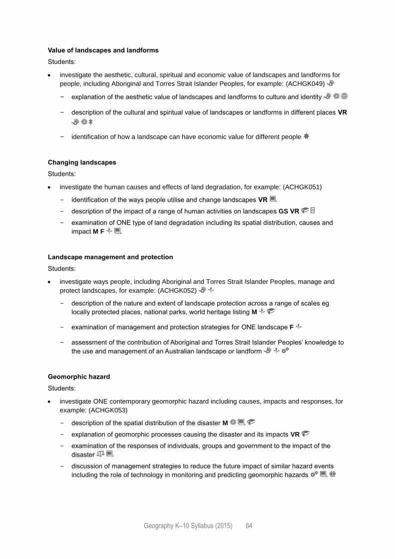
Geography K–10 Syllabus (2015) 64
Value of landscapes and landforms
Students:
investigate the aesthetic, cultural, spiritual and economic value of landscapes and landforms for
people, including Aboriginal and Torres Strait Islander Peoples, for example: (ACHGK049)
- explanation of the aesthetic value of landscapes and landforms to culture and identity
- description of the cultural and spiritual value of landscapes or landforms in different places VR
- identification of how a landscape can have economic value for different people
Changing landscapes
Students:
investigate the human causes and effects of land degradation, for example: (ACHGK051)
- identification of the ways people utilise and change landscapes VR
- description of the impact of a range of human activities on landscapes GS VR
- examination of ONE type of land degradation including its spatial distribution, causes and
impact M F
Landscape management and protection
Students:
investigate ways people, including Aboriginal and Torres Strait Islander Peoples, manage and
protect landscapes, for example: (ACHGK052)
- description of the nature and extent of landscape protection across a range of scales eg
locally protected places, national parks, world heritage listing M
- examination of management and protection strategies for ONE landscape F
- assessment of the contribution of Aboriginal and Torres Strait Islander Peoples’ knowledge to
the use and management of an Australian landscape or landform
Geomorphic hazard
Students:
investigate ONE contemporary geomorphic hazard including causes, impacts and responses, for
example: (ACHGK053)
- description of the spatial distribution of the disaster M
- explanation of geomorphic processes causing the disaster and its impacts VR
- examination of the responses of individuals, groups and government to the impact of the
disaster
- discussion of management strategies to reduce the future impact of similar hazard events
including the role of technology in monitoring and predicting geomorphic hazards
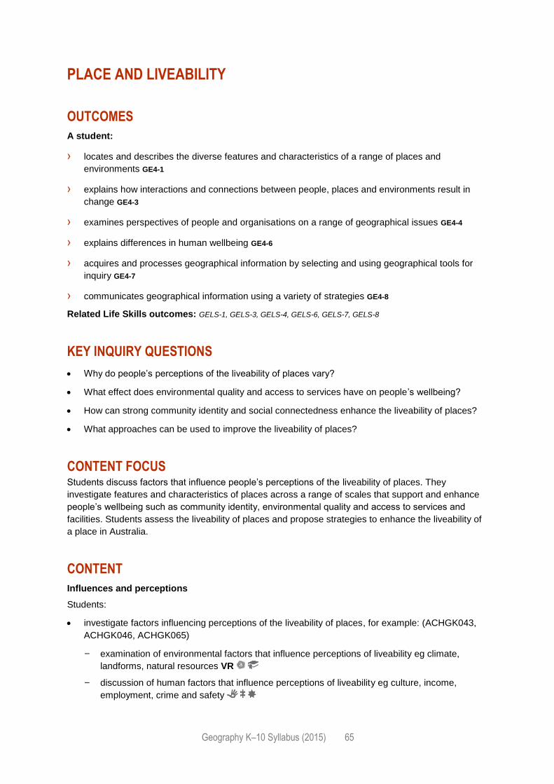
Geography K–10 Syllabus (2015) 65
PLACE AND LIVEABILITY
OUTCOMES
A student:
› locates and describes the diverse features and characteristics of a range of places and
environments GE4-1
› explains how interactions and connections between people, places and environments result in
change GE4-3
› examines perspectives of people and organisations on a range of geographical issues GE4-4
› explains differences in human wellbeing GE4-6
› acquires and processes geographical information by selecting and using geographical tools for
inquiry GE4-7
› communicates geographical information using a variety of strategies GE4-8
Related Life Skills outcomes: GELS-1, GELS-3, GELS-4, GELS-6, GELS-7, GELS-8
KEY INQUIRY QUESTIONS
Why do people’s perceptions of the liveability of places vary?
What effect does environmental quality and access to services have on people’s wellbeing?
How can strong community identity and social connectedness enhance the liveability of places?
What approaches can be used to improve the liveability of places?
CONTENT FOCUS Students discuss factors that influence people’s perceptions of the liveability of places. They
investigate features and characteristics of places across a range of scales that support and enhance
people’s wellbeing such as community identity, environmental quality and access to services and
facilities. Students assess the liveability of places and propose strategies to enhance the liveability of
a place in Australia.
CONTENT
Influences and perceptions
Students:
investigate factors influencing perceptions of the liveability of places, for example: (ACHGK043,
ACHGK046, ACHGK065)
- examination of environmental factors that influence perceptions of liveability eg climate,
landforms, natural resources VR
- discussion of human factors that influence perceptions of liveability eg culture, income,
employment, crime and safety
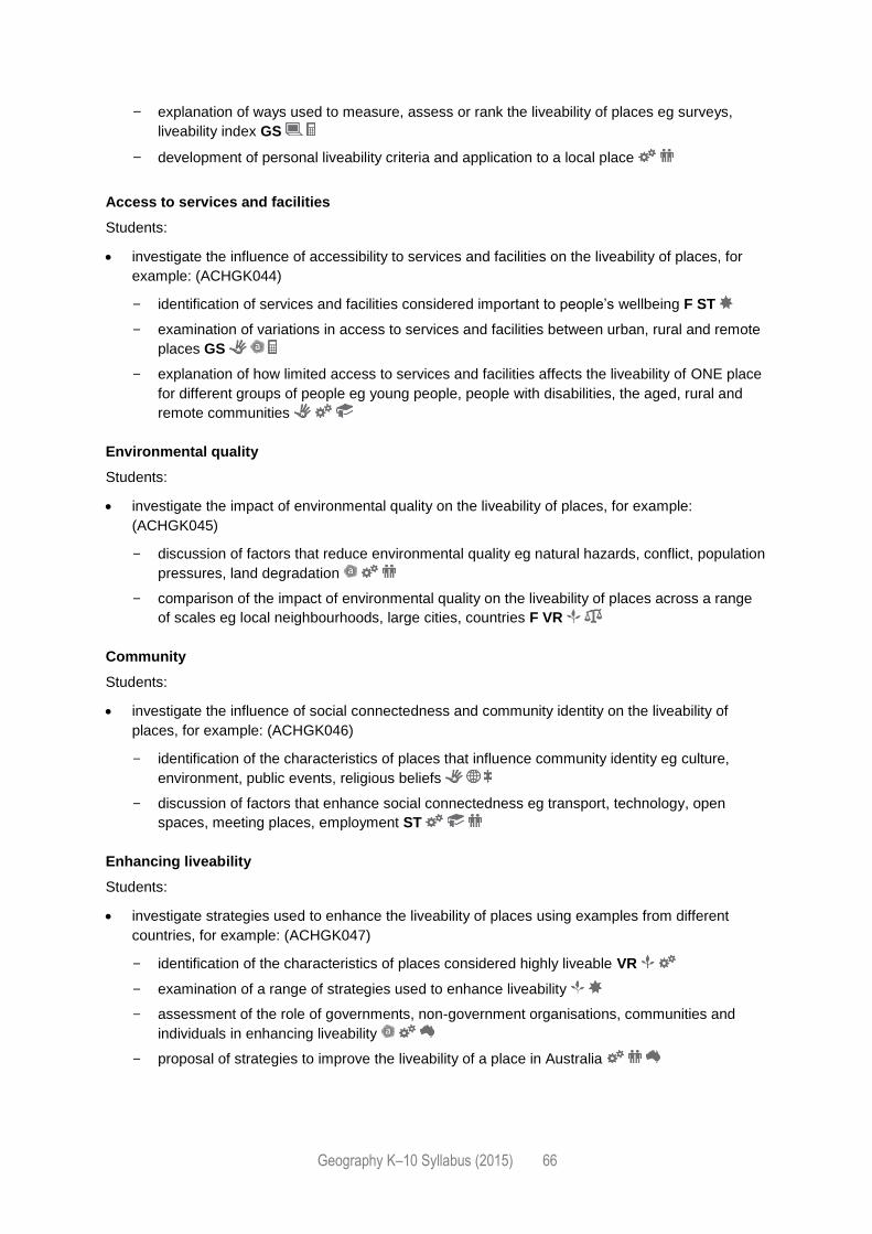
Geography K–10 Syllabus (2015) 66
- explanation of ways used to measure, assess or rank the liveability of places eg surveys,
liveability index GS
- development of personal liveability criteria and application to a local place
Access to services and facilities
Students:
investigate the influence of accessibility to services and facilities on the liveability of places, for
example: (ACHGK044)
- identification of services and facilities considered important to people’s wellbeing F ST
- examination of variations in access to services and facilities between urban, rural and remote
places GS
- explanation of how limited access to services and facilities affects the liveability of ONE place
for different groups of people eg young people, people with disabilities, the aged, rural and
remote communities
Environmental quality
Students:
investigate the impact of environmental quality on the liveability of places, for example:
(ACHGK045)
- discussion of factors that reduce environmental quality eg natural hazards, conflict, population
pressures, land degradation
- comparison of the impact of environmental quality on the liveability of places across a range
of scales eg local neighbourhoods, large cities, countries F VR
Community
Students:
investigate the influence of social connectedness and community identity on the liveability of
places, for example: (ACHGK046)
- identification of the characteristics of places that influence community identity eg culture,
environment, public events, religious beliefs
- discussion of factors that enhance social connectedness eg transport, technology, open
spaces, meeting places, employment ST
Enhancing liveability
Students:
investigate strategies used to enhance the liveability of places using examples from different
countries, for example: (ACHGK047)
- identification of the characteristics of places considered highly liveable VR
- examination of a range of strategies used to enhance liveability
- assessment of the role of governments, non-government organisations, communities and
individuals in enhancing liveability
- proposal of strategies to improve the liveability of a place in Australia
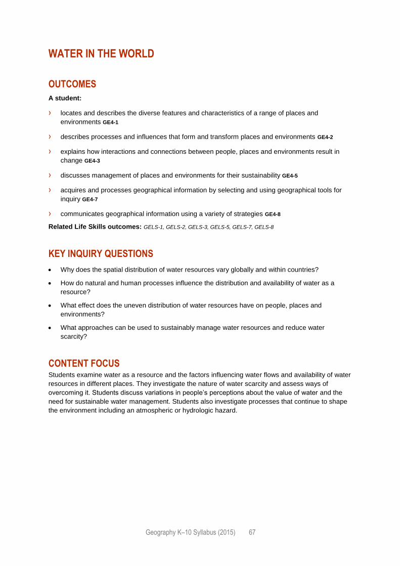
Geography K–10 Syllabus (2015) 67
WATER IN THE WORLD
OUTCOMES
A student:
› locates and describes the diverse features and characteristics of a range of places and
environments GE4-1
› describes processes and influences that form and transform places and environments GE4-2
› explains how interactions and connections between people, places and environments result in
change GE4-3
› discusses management of places and environments for their sustainability GE4-5
› acquires and processes geographical information by selecting and using geographical tools for
inquiry GE4-7
› communicates geographical information using a variety of strategies GE4-8
Related Life Skills outcomes: GELS-1, GELS-2, GELS-3, GELS-5, GELS-7, GELS-8
KEY INQUIRY QUESTIONS
Why does the spatial distribution of water resources vary globally and within countries?
How do natural and human processes influence the distribution and availability of water as a
resource?
What effect does the uneven distribution of water resources have on people, places and
environments?
What approaches can be used to sustainably manage water resources and reduce water
scarcity?
CONTENT FOCUS Students examine water as a resource and the factors influencing water flows and availability of water
resources in different places. They investigate the nature of water scarcity and assess ways of
overcoming it. Students discuss variations in people’s perceptions about the value of water and the
need for sustainable water management. Students also investigate processes that continue to shape
the environment including an atmospheric or hydrologic hazard.
Geography K–10 Syllabus (2015) 68
CONTENT
Water resources
Students:
investigate the characteristics and spatial distribution of global water resources, for example:
(ACHGK037)
- classification of water resources
- identification of different forms of water used as resources VR
- examination of spatial distribution patterns of water resources M ST
The water cycle
Students:
investigate how the operation of the water cycle connects people and places, for example:
(ACHGK038)
- identification of water cycle processes VR
- explanation of water flows within a catchment area M ST
- examination of factors influencing water flows and the availability of water resources in
different places eg latitude, altitude, topography, location, climate change M VR
Australia’s water resources
Students:
investigate the quantity and variability of water resources in Australia and other places, for
example: (ACHGK039)
- analysis of spatial variations in Australia’s water resources eg groundwater, rivers M GS
- explanation of variations in freshwater water availability across Australia eg precipitation,
groundwater, runoff VR
- assessment of variations in freshwater water availability between continents M GS
Water scarcity and water management
Students:
investigate the nature of water scarcity and ways of overcoming it, for example: (ACHGK040)
- description of the nature, extent and causes of water scarcity in different countries M GS
- assessment of strategies used to overcome water scarcity and the role of governments, non-
government organisations, individuals and communities in sustainable water management
- proposal of individual actions contributing to water management
Geography K–10 Syllabus (2015) 69
The value of water
Students:
investigate the economic, cultural, spiritual and aesthetic values of water for people, including
Aboriginal and Torres Strait Islander Peoples and/or peoples of the Asia region, for example:
(ACHGK041)
- description of the ways water is used by people eg agricultural, commercial, industrial and
recreational uses VR
- discussion of variations in people’s perceptions about the value of water eg economic versus
aesthetic
- comparison of the importance of water to ONE Aboriginal or Torres Strait Islander community
and/or ONE Asian community
Natural hazard
Students:
investigate ONE contemporary atmospheric hazard or hydrologic hazard including causes,
impacts and responses, for example: (ACHGK042)
- explanation of the spatial distribution, cause and impact of the disaster M VR
- examination of responses by individuals, groups and government to the impact of the disaster
- prediction of the impact of climate change on the occurrence, frequency and extent of this
type of hazard M ST
- discussion of management strategies to reduce the future impact of similar hazard events
Geography K–10 Syllabus (2015) 70
INTERCONNECTIONS
OUTCOMES
A student:
› describes processes and influences that form and transform places and environments GE4-2
› explains how interactions and connections between people, places and environments result in
change GE4-3
› examines perspectives of people and organisations on a range of geographical issues GE4-4
› discusses management of places and environments for their sustainability GE4-5
› acquires and processes geographical information by selecting and using geographical tools for
inquiry GE4-7
› communicates geographical information using a variety of strategies GE4-8
Related Life Skills outcomes: GELS-2, GELS-3, GELS-4, GELS-5, GELS-7, GELS-8
KEY INQUIRY QUESTIONS
How are people and places connected to other places?
What role does technology play in connecting people to people, goods, services and information
in other places?
What are the consequences of a globally connected world for people and places?
Why are interconnections important for the future of places and environments?
CONTENT FOCUS Students focus on the connections people have to places across a range of scales. They examine
what shapes people’s perceptions of places and how this influences their connections to places.
Students explore how transport, information and communication technologies and trade link people to
many places. They explain the effects of human activities, such as production, recreation and travel,
on places and environments in Australia and across the world and investigate sustainability initiatives
and possible futures for these places.
CONTENT
Personal connections
Students:
investigate the influences on and effects of, people’s travel and recreational, cultural or leisure
connections with different places for the future, for example: (ACHGK065, ACHGK069)
- analysis of patterns and trends in people’s travel, recreational, cultural and/or leisure activities
GS
Geography K–10 Syllabus (2015) 71
- examination of the impact of people’s travel, recreational, cultural and/or leisure activities on
the future of places VR
- explanation of the impacts of a selected travel, recreational, cultural or leisure activity on a
place, implications for the future of that place and strategies to achieve sustainability M
Technology
Students:
investigate the way transportation and information and communication technologies are used to
connect people to services, information and people in other places, for example: (ACHGK066)
- explanation of how transport technologies connect people to places M ST
- examination of how information and communication technologies increases people’s
connections to services, information and people in other places
- assessment of the impact of increasing global connectivity on people and places
Trade
Students:
investigate the ways places and people are interconnected through trade in goods and services
across a range of scales, for example: (ACHGK067)
- identification of trade connections in Australia eg local farmers markets, inter-state business
- examination of a country’s trade links with other countries eg major trade partners, sources of
raw materials M GS
- analysis of spatial patterns of global trade eg countries of production and consumption, global
shipping and freight routes M ST
Production and consumption
Students:
investigate the effects of the production and consumption of goods on people, places and
environments throughout the world, for example: (ACHGK068)
- examination of environmental, social and economic impacts of production and consumption of
consumer goods GS
- assessment of the effect of production or consumption of goods on ONE place or environment
VR
- explanation of responses by governments, groups and individuals to minimise the effects of
production and consumption
Geography K–10 Syllabus (2015) 72
CONTENT FOR STAGE 5
(100 hours minimum teaching time)
Sustainable Biomes Changing Places
Environmental Change and Management Human Wellbeing
OVERVIEW OF TEACHING AND LEARNING
In considering the intended learning, teachers will make decisions about the sequence, the emphasis
to be given to particular areas of content, and any adjustments required based on the needs, interests
and abilities of their students. Content including knowledge and understanding, concepts, skills and
tools should be integrated to provide meaningful learning experiences for students. All students must
undertake fieldwork in Stage 5.
Where appropriate, students are to be provided with opportunities to investigate a wide range of
places and environments from local to global scales.
THE FOLLOWING GEOGRAPHICAL CONCEPTS ARE TO BE
INTEGRATED THROUGHOUT STAGE 5:
Place: the significance of places and what they are like eg the effect of local and global
geographical processes such as urbanisation, migration and climate change on tangible places
such as a country as well as less tangible places such as a community.
Space: the significance of location and spatial distribution, and ways people organise and
manage the spaces that we live in eg location of biomes and the spatial distribution of
urbanisation, global patterns of food, industrial materials and fibre production and variations of
human wellbeing; conflicts arising from competing uses of space for agricultural, urban,
recreational and industrial land uses.
Environment: the significance of the environment in human life, and the important
interrelationships between humans and the environment eg the function and importance of the
environment; the quality of the environment; significant environmental challenges; approaches to
environmental management.
Interconnection: no object of geographical study can be viewed in isolation eg consequences of
migration patterns on the location of origin and destination; the economic, social and
environmental factors influencing spatial variations in global human wellbeing.
Scale: the way that geographical phenomena and problems can be examined at different spatial
levels eg interactions between geographical processes at different scales; local alterations to
environments can have global consequences; changes at a global level can impact local
environments; management and protection of places and environments at local, regional, national
and global scales.
Sustainability: the capacity of the environment to continue to support our lives and the lives of
other living creatures into the future eg short and long-term implications of environmental change
Geography K–10 Syllabus (2015) 73
on environments; the importance of sustainable practices to ensure the wellbeing of people;
sustainable environmental worldviews and management approaches.
Change: explaining geographical phenomena by investigating how they have developed over
time eg biomes altered to produce food, industrial materials and fibres and the environmental
effects of these alterations; the consequences of urbanisation; the protection of places and
environments as a result of sustainable management practices.
THE FOLLOWING GEOGRAPHICAL INQUIRY SKILLS ARE TO BE
INTEGRATED THROUGHOUT STAGE 5:
Acquiring geographical information
develop geographically significant questions and plan an inquiry that identifies and applies
appropriate geographical methodologies and concepts (ACHGS063, ACHGS072)
collect, select, record and organise relevant data and geographical information, using ethical
protocols, from a variety of appropriate primary data and secondary information sources
(ACHGS064, ACHGS073)
Processing geographical information
evaluate information sources for their reliability, bias and usefulness (ACHGS065, ACHGS073)
represent multi-variable data in a range of appropriate forms, with and without the use of digital
and spatial technologies (ACHGS065, ACHGS074)
represent the spatial distribution of geographical phenomena on maps that conform to
cartographic conventions, using spatial technologies as appropriate (ACHGS066, ACHGS075)
evaluate multi-variable data and other geographical information using qualitative and quantitative
methods and digital and spatial technologies as appropriate to make generalisations and
inferences, propose explanations for patterns, trends, relationships and anomalies, and predict
outcomes (ACHGS067, ACHGS076)
apply geographical concepts to synthesise information from various sources and draw
conclusions based on the analysis of data and information, taking into account alternative
perspectives (ACHGS068, ACHGS077)
identify how geographic information systems (GIS) might be used to analyse geographical data
and make predictions (ACHGS069, ACHGS078)
Communicating geographical information
present findings, arguments and explanations in a range of appropriate communication forms
selected for their effectiveness and to suit audience and purpose, using relevant geographical
terminology and digital technologies as appropriate (ACHGS070, ACHGS079)
reflect on and evaluate the findings of an inquiry to propose individual and collective action in
response to a contemporary geographical challenge, taking account of environmental, economic
and social considerations; and explain the predicted outcomes and consequences of their
proposal (ACHGS071, ACHGS080)
Geography K–10 Syllabus (2015) 74
THE FOLLOWING GEOGRAPHICAL TOOLS ARE TO BE
INTEGRATED THROUGHOUT STAGE 5:
Examples may include:
Maps – M
relief maps, political maps, topographic maps, choropleth maps, flowline maps, cadastral maps,
thematic maps, isoline maps, land use maps, précis maps, cultural mapping, special-purpose
maps, cartograms, synoptic charts
maps to identify direction, scale and distance, area and grid references, degrees and minutes of
latitude and longitude, bearings, aspect, altitude, area, density, contour lines, gradient, local relief
Fieldwork – F
observing, measuring, collecting and recording data, developing and conducting surveys and
interviews
fieldwork instruments such as weather instruments, vegetation identification charts, compasses,
clinometers, GPS, GIS or remote sensing
Graphs and statistics – GS
data tables, pie graphs, column graphs, compound column graphs, line graphs, scatter graphs,
climate graphs, population profiles, multiple tables and graphs presented on a geographical
theme, statistics to find patterns and trends, and to account for change
Spatial technologies – ST
virtual maps, satellite images, global positioning systems (GPS), geographic information systems
(GIS), remote sensing data, augmented reality
Visual representations – VR
photographs, aerial photographs, illustrations, flow charts, annotated diagrams, multimedia, field
and photo sketches, cartoons, mind maps, web and app tools
Geography K–10 Syllabus (2015) 75
SUSTAINABLE BIOMES
OUTCOMES
A student:
› explains the diverse features and characteristics of a range of places and environments GE5-1
› explains processes and influences that form and transform places and environments GE5-2
› analyses the effect of interactions and connections between people, places and environments GE5-3
› assesses management strategies for places and environments for their sustainability GE5-5
› acquires and processes geographical information by selecting and using appropriate and relevant
geographical tools for inquiry GE5-7
› communicates geographical information to a range of audiences using a variety of strategies GE5-8
Related Life Skills outcomes: GELS-1, GELS-2, GELS-3, GELS-5, GELS-7, GELS-8
KEY INQUIRY QUESTIONS
What are the main characteristics that differentiate the world’s biomes?
How do people use and alter biomes for food production?
Can the world’s biomes sustainably feed the world’s population?
What strategies can be used to increase global food security?
CONTENT FOCUS Students examine the physical characteristics and productivity of biomes. Students examine the
correlation between the world’s climatic zones and spatial distributions of biomes and their capacity to
support food and non-food agricultural production. Students analyse the impact humans have on
biomes in an effort to produce food and increase agricultural yields. They examine population trends
and projections from Australia and across the world and forecast future food supply-and-demand
issues. Challenges to food production are explored and management strategies investigated.
CONTENT
Biomes
Students:
investigate the distribution and physical characteristics of biomes, for example: (ACHGK060)
- examination of the spatial distribution of biomes M ST
- identification of biomes used to produce food, industrial materials and fibres VR
- explanation of the impact of the climate, soils and vegetation of a biome on its productivity GS
VR
Geography K–10 Syllabus (2015) 76
Changing biomes
Students:
investigate the human alteration of biomes to produce food, industrial materials and fibres and the
environmental effects of these alterations, for example: (ACHGK061)
- examination of human alterations to the physical characteristics of biomes eg vegetation
removal, agriculture, land terracing, irrigation, mining VR
- assessment of environmental impacts of human alterations to biomes eg habitat and
biodiversity loss, water pollution, salinity GS ST
- discussion of successful sustainability strategies that minimise environmental impacts
Biomes produce food
Students:
investigate environmental, economic and technological factors that influence agricultural yields in
Australia and across the world, for example: (ACHGK062)
- examination of how environmental factors influence agricultural yields eg temperature, water
availability, soil, topography F
- discussion of economic factors affecting agricultural yields eg global trade, commercialisation
of agriculture GS
- explanation of how technology is used to increase agricultural yields eg innovations and
advancements in farming practices VR
Challenges to food production
Students:
investigate environmental challenges to food production for Australia and other areas of the world,
for example: (ACHGK063)
- description of the impact of water scarcity and pollution on food production VR
- discussion of the impact of land degradation and competing land uses on food production eg
urban expansion, biofuel production F ST
- assessment of the extent to which climate change can affect the capacity of countries to
increase food production GS
Food security
Students:
investigate the capacity of the world’s biomes to achieve sustainable food security for Australia
and the world, for example: (ACHGK064)
- assessment of the capacity of biomes to produce food into the future
- analysis of population projections to predict future demand for food M GS
- examination of sustainable practices used to achieve food security VR
- discussion of the potential for Australia to contribute to global food security
Geography K–10 Syllabus (2015) 77
CHANGING PLACES
OUTCOMES
A student:
› explains processes and influences that form and transform places and environments GE5-2
› analyses the effect of interactions and connections between people, places and environments GE5-3
› assesses management strategies for places and environments for their sustainability GE5-5
› acquires and processes geographical information by selecting and using appropriate and relevant
geographical tools for inquiry GE5-7
› communicates geographical information to a range of audiences using a variety of strategies GE5-8
Related Life Skills outcomes: GELS-2, GELS-3, GELS-5, GELS-7, GELS-8
KEY INQUIRY QUESTIONS
Why has the world become more urbanised?
How does migration impact on the concentration of people into urban places?
How does urbanisation change environments and places?
What strategies are used to manage environmental change in urban places to enhance
sustainability?
CONTENT FOCUS Students examine the patterns and trends in population movements and the increasing urbanisation
of countries. They discuss the reasons for internal and international migration patterns and the
consequences of population movements, including the increased concentration of populations within
countries. Students examine strategies to create liveable and sustainable urban places, propose
solutions and suggest opportunities for active citizenship.
CONTENT
Causes and consequences of urbanisation
Students:
investigate the causes and consequences of urbanisation with reference to ONE Asian country,
for example: (ACHGK054)
- identification of spatial distribution patterns M GS
- description of the causes of urbanisation
- examination of economic, social or environmental consequences of urbanisation VR
Geography K–10 Syllabus (2015) 78
Urban settlement patterns
Students:
investigate differences in urban settlement patterns between Australia and another country, for
example: (ACHGK055)
- examination of urban settlements to determine patterns of concentration GS ST
- explanation of factors influencing urban concentration eg climate and topography,
transportation networks, land use or perceptions of liveability F VR
- assessment of the consequences of urban concentrations on the characteristics, liveability
and sustainability of places
Internal migration
Students:
investigate reasons for and effects of internal migration in Australia and another country, for
example: (ACHGK056, ACHGK057)
- analysis of trends in temporary and permanent internal migration GS
- discussion of economic, social or environmental consequences of internal migration on places
of origin and destination
International migration
Students:
investigate the reasons for and effects of international migration to Australia, for example:
(ACHGK058)
- analysis of international migration patterns M GS
- explanation of where and why international migrants settle within Australia M
- examination of characteristics and spatial patterns of Australia’s cultural diversity F VR
Australia’s urban future
Students:
investigate the management and planning of Australia’s urban future, for example: (ACHGK059)
- description of Australia’s projected population growth GS
- discussion of the implication of population forecasts for the future growth and sustainability
of urban places
- explanation of strategies used to create economically, socially and environmentally
sustainable urban places
- proposal of ways for individuals and communities to contribute to a sustainable urban
future
Geography K–10 Syllabus (2015) 79
ENVIRONMENTAL CHANGE AND MANAGEMENT
OUTCOMES
A student:
› explains processes and influences that form and transform places and environments GE5-2
› analyses the effect of interactions and connections between people, places and environments GE5-3
› accounts for perspectives of people and organisations on a range of geographical issues GE5-4
› assesses management strategies for places and environments for their sustainability GE5-5
› acquires and processes geographical information by selecting and using appropriate and relevant
geographical tools for inquiry GE5-7
› communicates geographical information to a range of audiences using a variety of strategies GE5-8
Related Life Skills outcomes: GELS-2, GELS-3, GELS-4, GELS-5, GELS-7, GELS-8
KEY INQUIRY QUESTIONS
How do environments function?
How do people’s worldviews affect their attitudes to and use of environments?
What are the causes and consequences of change in environments and how can this change be
managed?
Why is an understanding of environmental processes and interconnections essential for
sustainable management of environments?
CONTENT FOCUS Students develop an understanding of the functioning of environments and the scale of human-
induced environmental change challenging sustainability. They explore worldviews influencing
approaches to environmental use and management. Students undertake an investigative study of the
causes and consequences of environmental change in an environment in Australia and another
country. They compare and evaluate the management responses in both countries and propose ways
individuals can contribute to environmental sustainability.
CONTENT
Environments
Students:
investigate the role and importance of natural environments, for example:
- identification of the function of natural environments in supporting life eg maintaining
biodiversity F VR
Geography K–10 Syllabus (2015) 80
Environmental change
Students:
investigate human-induced environmental changes across a range of scales, for example:
(ACHGK070)
- brief examination of types, and extent, of environmental change F VR
Environmental management
Students:
investigate environmental management, including various worldviews and the management
approaches of Aboriginal and Torres Strait Islander Peoples, for example: (ACHGK071,
ACHGK072)
- discussion of varying environmental management approaches and perspectives
Investigative study
Select ONE type of environment in Australia as the context for a comparative study with at least ONE
other country.
Students:
investigate the biophysical processes essential to the functioning of the selected environment
- explanation of how the biophysical processes operating in the environment maintain its
functioning F
investigate the causes, extent and consequences of the environmental change (ACHGK073)
- examination of the causes and extent of change to the environment in each country M GS
- analysis of the short and long-term consequences of the environmental change in each
country
investigate the management of the environmental change, for example: (ACHGK074,
ACHGK075)
- discussion of the factors influencing the management responses in each country eg
worldviews, competing demands, technology, climate change
- comparison and evaluation of the effectiveness of the management responses in achieving
environmental sustainability
- proposal of how individuals could contribute to achieving environmental sustainability for the
environment in each country
Geography K–10 Syllabus (2015) 81
HUMAN WELLBEING
OUTCOMES
A student:
› explains the diverse features and characteristics of a range of places and environments GE5-1
› explains processes and influences that form and transform places and environments GE5-2
› analyses differences in human wellbeing and ways to improve human wellbeing GE5-6
› acquires and processes geographical information by selecting and using appropriate and relevant
geographical tools for inquiry GE5-7
› communicates geographical information to a range of audiences using a variety of strategies GE5-8
Related Life Skills outcomes: GELS-1, GELS-2, GELS-6, GELS-7, GELS-8
KEY INQUIRY QUESTIONS
What makes human wellbeing a geographical issue?
How can the spatial variations in human wellbeing and development be measured and explained?
What are the economic, social and environmental impacts of variations in development and
human wellbeing?
How do governments, groups and individuals respond to inequalities in development and human
wellbeing for a sustainable future?
CONTENT FOCUS
Students examine the nature of, and differences in, human wellbeing and development that exist
within and between countries. They describe ways of measuring human wellbeing and development to
reveal spatial variations and develop explanations for differences. Students investigate examples from
Australia and across the world of issues affecting development, the impact on human wellbeing and
the consequences of spatial variations across scales. Local, national and global initiatives to improve
human wellbeing are also examined.
CONTENT
Human wellbeing and development
Students:
investigate ways of measuring and mapping human wellbeing and development, for example:
(ACHGK076)
- examination of global indicators and benchmarks for human wellbeing GS
- description of ways of measuring and mapping human wellbeing and development for the
purpose of identifying and analysing spatial variations
- analysis of contemporary trends in human wellbeing and development GS
Geography K–10 Syllabus (2015) 82
Spatial variations in human wellbeing
Students:
investigate causes, issues and consequences of spatial variations in human wellbeing, for
example: (ACHGK077, ACHGK078, ACHGK079)
- description of spatial variations in human wellbeing and development between and within
countries using selected indicators M GS
- examination of reasons for and consequences of spatial variations in human wellbeing and
development VR
- discussion of issues affecting the development of places and their impact on human wellbeing
in ONE country or region ST
Human wellbeing in Australia
Students:
investigate the reasons for and consequences of spatial variations in human wellbeing in
Australia, for example: (ACHGK080)
- identification of differences in human wellbeing in Australia using a range of indicators GS
- examination of reasons for and consequences of differences in human wellbeing for TWO
groups of people in Australia eg cultural groups, unemployed, the aged, young people, people
with disabilities VR
- analysis of how human wellbeing is influenced by where people live in Australia M
Improving human wellbeing
Students:
investigate initiatives to improve human wellbeing in Australia and other countries, for example:
(ACHGK081)
- evaluation of initiatives by governments and non-government organisations to reduce spatial
variations in human wellbeing
- discussion of the role individuals play in improving human wellbeing
- proposal for action by governments, organisations or individuals to improve the wellbeing of
ONE group in Australia
Geography K–10 Syllabus (2015) 83
YEARS 7–10 LIFE SKILLS OUTCOMES AND CONTENT
The Years 7–10 Life Skills outcomes and content are developed from the objectives of the Geography
K–10 Syllabus.
Before deciding that a student should undertake a course based on Life Skills outcomes and content,
consideration should be given to other ways of assisting the student to engage with the regular course
outcomes. This assistance may include a range of adjustments to the teaching, learning and
assessment activities.
If the adjustments do not provide a student with sufficient access to some or all of the Stage 4 and
Stage 5 outcomes, a decision can be explored for the student to undertake Life Skills outcomes and
content. This decision should be made through the collaborative curriculum planning process involving
the student and parent/carer and other significant individuals. School principals are responsible for the
management of the collaborative curriculum planning process.
The following points need to be taken into consideration:
students are required to demonstrate achievement of one or more Life Skills outcomes
specific Life Skills outcomes should be selected based on the needs, strengths, goals, interests
and prior learning of each student
achievement of an outcome may be demonstrated through selected Life Skills content
outcomes may be demonstrated independently or with support.
Further information in relation to planning, implementing and assessing Life Skills outcomes and
content can be found in support materials for:
Human Society and its Environment (HSIE)
Special Education
Life Skills.
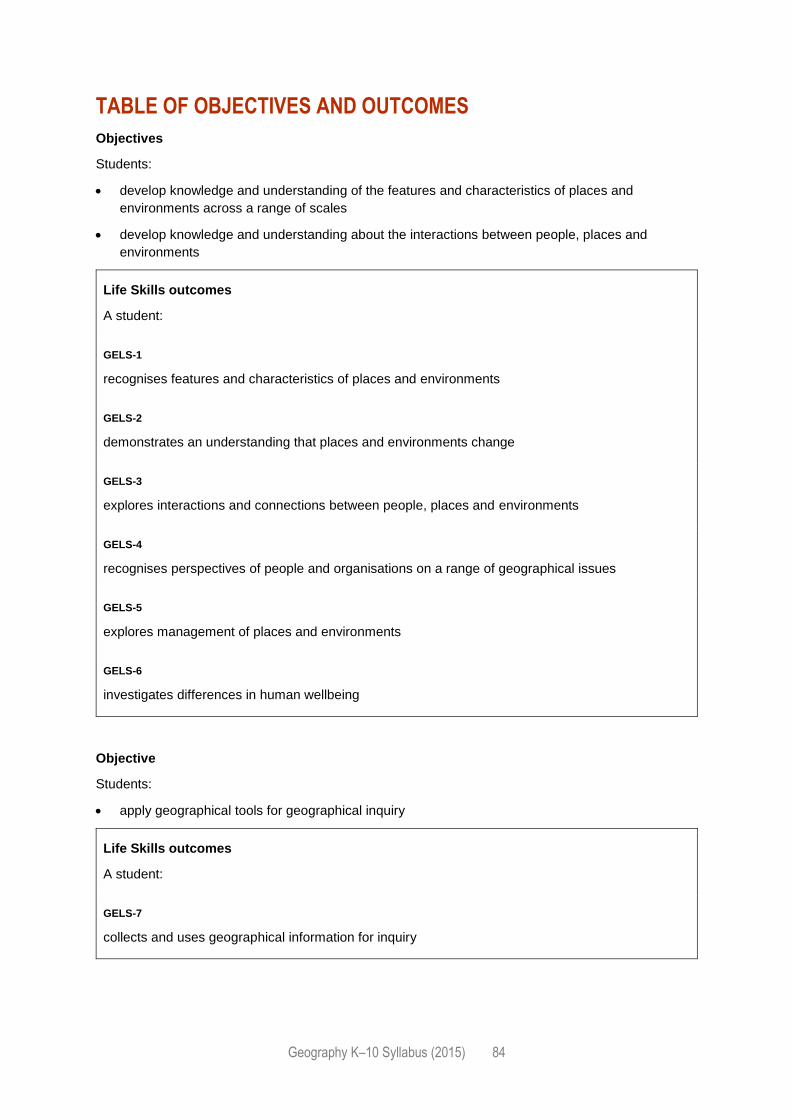
Geography K–10 Syllabus (2015) 84
TABLE OF OBJECTIVES AND OUTCOMES
Objectives
Students:
develop knowledge and understanding of the features and characteristics of places and
environments across a range of scales
develop knowledge and understanding about the interactions between people, places and
environments
Life Skills outcomes
A student:
GELS-1
recognises features and characteristics of places and environments
GELS-2
demonstrates an understanding that places and environments change
GELS-3
explores interactions and connections between people, places and environments
GELS-4
recognises perspectives of people and organisations on a range of geographical issues
GELS-5
explores management of places and environments
GELS-6
investigates differences in human wellbeing
Objective
Students:
apply geographical tools for geographical inquiry
Life Skills outcomes
A student:
GELS-7
collects and uses geographical information for inquiry

Geography K–10 Syllabus (2015) 85
Objective
Students:
develop skills to acquire, process and communicate geographical information
Life Skills outcomes
A student:
GELS-8
communicates geographical information
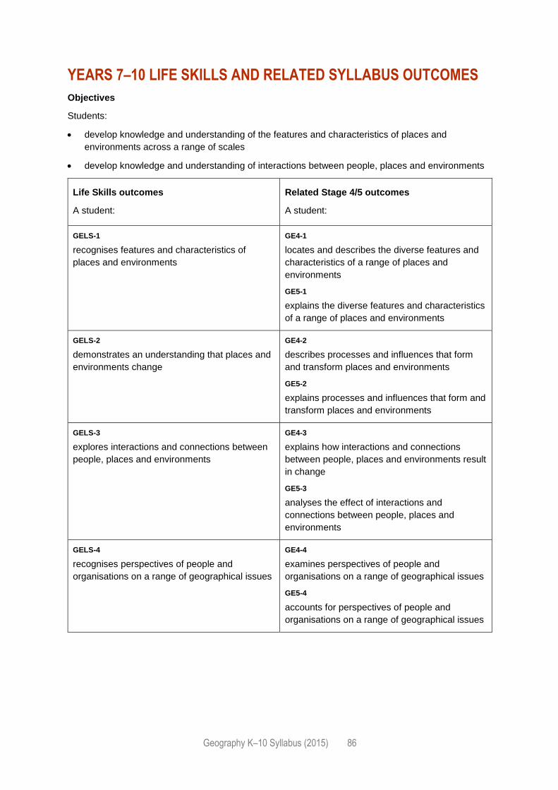
Geography K–10 Syllabus (2015) 86
YEARS 7–10 LIFE SKILLS AND RELATED SYLLABUS OUTCOMES
Objectives
Students:
develop knowledge and understanding of the features and characteristics of places and
environments across a range of scales
develop knowledge and understanding of interactions between people, places and environments
Life Skills outcomes
A student:
Related Stage 4/5 outcomes
A student:
GELS-1
recognises features and characteristics of
places and environments
GE4-1
locates and describes the diverse features and
characteristics of a range of places and
environments
GE5-1
explains the diverse features and characteristics
of a range of places and environments
GELS-2
demonstrates an understanding that places and
environments change
GE4-2
describes processes and influences that form
and transform places and environments
GE5-2
explains processes and influences that form and
transform places and environments
GELS-3
explores interactions and connections between
people, places and environments
GE4-3
explains how interactions and connections
between people, places and environments result
in change
GE5-3
analyses the effect of interactions and
connections between people, places and
environments
GELS-4
recognises perspectives of people and
organisations on a range of geographical issues
GE4-4
examines perspectives of people and
organisations on a range of geographical issues
GE5-4
accounts for perspectives of people and
organisations on a range of geographical issues
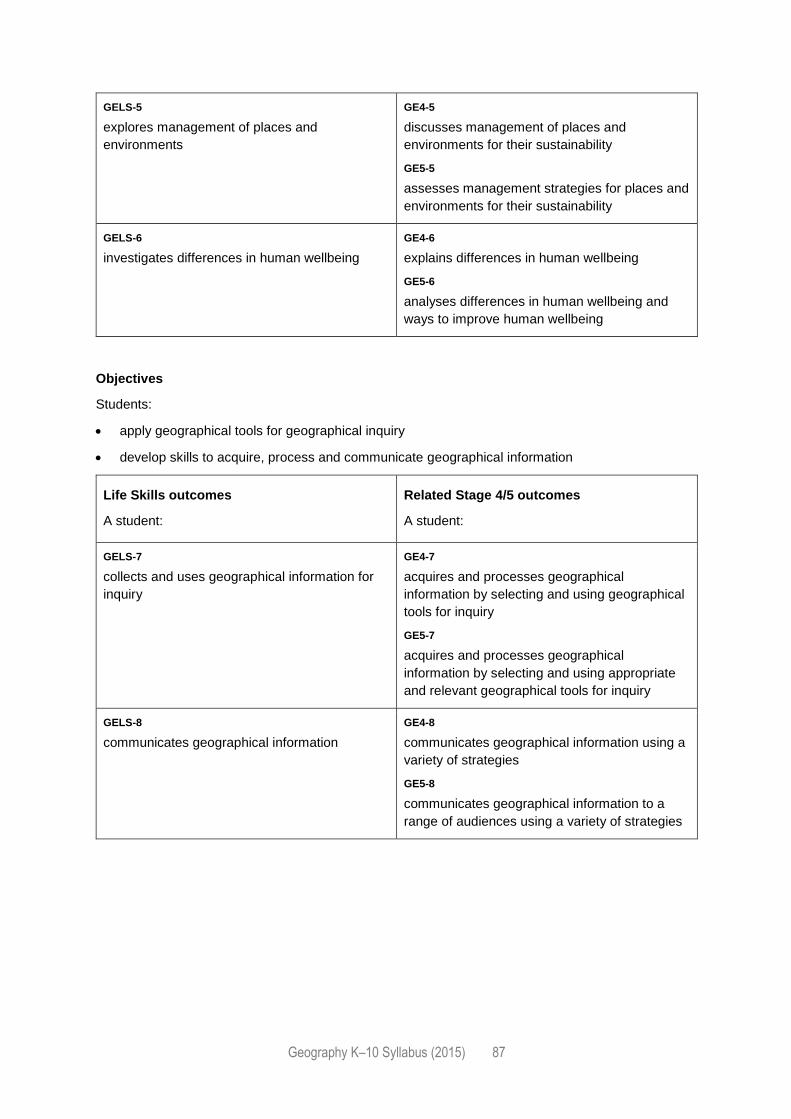
Geography K–10 Syllabus (2015) 87
GELS-5
explores management of places and
environments
GE4-5
discusses management of places and
environments for their sustainability
GE5-5
assesses management strategies for places and
environments for their sustainability
GELS-6
investigates differences in human wellbeing
GE4-6
explains differences in human wellbeing
GE5-6
analyses differences in human wellbeing and
ways to improve human wellbeing
Objectives
Students:
apply geographical tools for geographical inquiry
develop skills to acquire, process and communicate geographical information
Life Skills outcomes
A student:
Related Stage 4/5 outcomes
A student:
GELS-7
collects and uses geographical information for
inquiry
GE4-7
acquires and processes geographical
information by selecting and using geographical
tools for inquiry
GE5-7
acquires and processes geographical
information by selecting and using appropriate
and relevant geographical tools for inquiry
GELS-8
communicates geographical information
GE4-8
communicates geographical information using a
variety of strategies
GE5-8
communicates geographical information to a
range of audiences using a variety of strategies
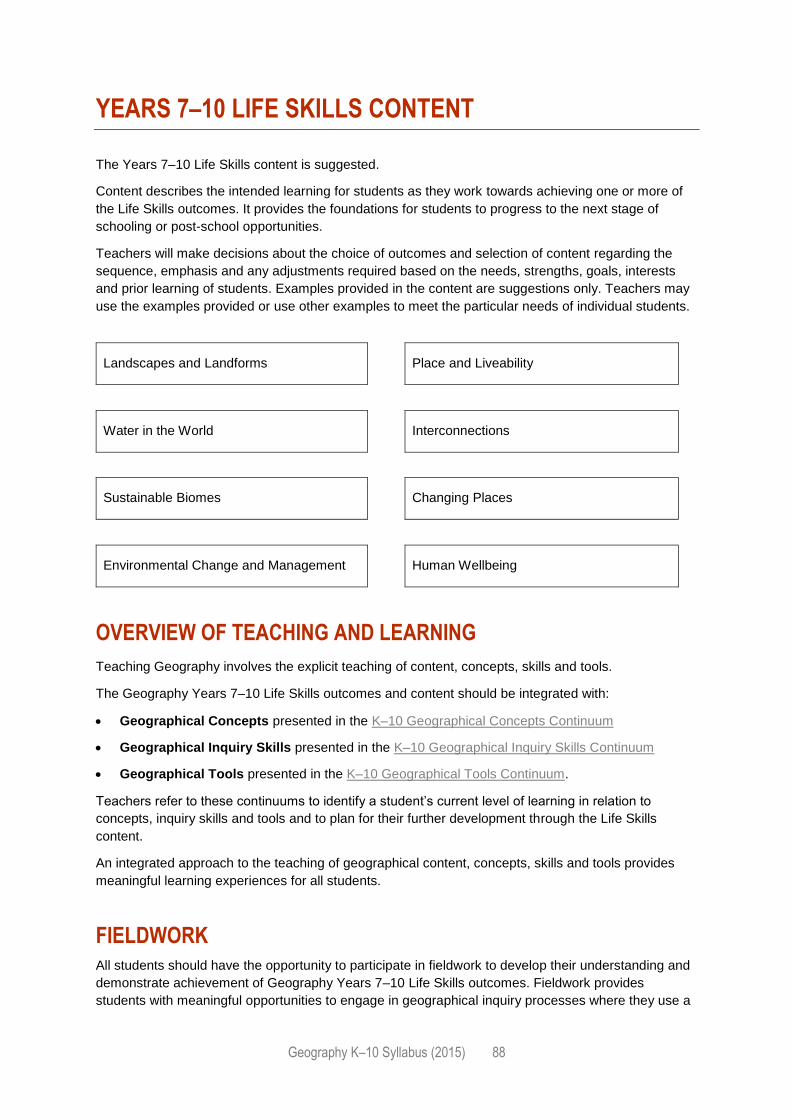
Geography K–10 Syllabus (2015) 88
YEARS 7–10 LIFE SKILLS CONTENT
The Years 7–10 Life Skills content is suggested.
Content describes the intended learning for students as they work towards achieving one or more of
the Life Skills outcomes. It provides the foundations for students to progress to the next stage of
schooling or post-school opportunities.
Teachers will make decisions about the choice of outcomes and selection of content regarding the
sequence, emphasis and any adjustments required based on the needs, strengths, goals, interests
and prior learning of students. Examples provided in the content are suggestions only. Teachers may
use the examples provided or use other examples to meet the particular needs of individual students.
Landscapes and Landforms Place and Liveability
Water in the World Interconnections
Sustainable Biomes Changing Places
Environmental Change and Management Human Wellbeing
OVERVIEW OF TEACHING AND LEARNING
Teaching Geography involves the explicit teaching of content, concepts, skills and tools.
The Geography Years 7–10 Life Skills outcomes and content should be integrated with:
Geographical Concepts presented in the K–10 Geographical Concepts Continuum
Geographical Inquiry Skills presented in the K–10 Geographical Inquiry Skills Continuum
Geographical Tools presented in the K–10 Geographical Tools Continuum.
Teachers refer to these continuums to identify a student’s current level of learning in relation to
concepts, inquiry skills and tools and to plan for their further development through the Life Skills
content.
An integrated approach to the teaching of geographical content, concepts, skills and tools provides
meaningful learning experiences for all students.
FIELDWORK
All students should have the opportunity to participate in fieldwork to develop their understanding and
demonstrate achievement of Geography Years 7–10 Life Skills outcomes. Fieldwork provides
students with meaningful opportunities to engage in geographical inquiry processes where they use a

Geography K–10 Syllabus (2015) 89
variety of strategies to locate, gather, select, organise and communicate geographical information
through the application of geographical skills and tools.
Some students with disability may require adjustments and/or additional support in order to engage in
fieldwork.
Geography K–10 Syllabus (2015) 90
LANDSCAPES AND LANDFORMS
OUTCOMES
A student:
› recognises features and characteristics of places and environments GELS-1
› demonstrates an understanding that places and environments change GELS-2
› recognises perspectives of people and organisations on a range of geographical issues GELS-4
› explores management of places and environments GELS-5
› collects and uses geographical information for inquiry GELS-7
› communicates geographical information GELS-8
Related Stage 4/5 outcomes: GE4-1, GE4-2, GE4-4, GE4-5, GE4-7, GE4-8, GE5-1, GE5-2, GE5-4,
GE5-5, GE5-7, GE5-8
KEY INQUIRY QUESTIONS
How are landscapes and landforms created?
What do landscapes and landforms mean to people?
How do people affect landscapes and landforms?
How do geomorphic hazards affect landscapes and landforms?
CONTENT FOCUS
Students explore the features of landscapes and landforms using examples from Australia and
throughout the world. They recognise how landscapes and landforms are created and acknowledge
the values and meanings placed on landscapes and landforms by different people. Students
investigate the impact humans have had on landscapes and ways to protect landscapes. Students
explore the effect of natural hazards on landscapes and how people attempt to prevent future
hazards.
GEOGRAPHICAL CONCEPTS, SKILLS AND TOOLS
Content including knowledge, understanding, concepts, skills and tools should be integrated to
provide meaningful learning experiences for students. Refer to the Overview of teaching and learning.
CONTENT
Features of landscapes and landforms
Students:
share information about familiar landscapes and landforms
research various landscapes and landforms M
Geography K–10 Syllabus (2015) 91
identify iconic landscapes and landforms within Australia and around the world VR
recognise how landscapes and landforms are created by different forces of nature eg mountains
created by volcanoes, rivers carved out by water, coastal headlands shaped by water and wind F
Value of landscapes and landforms for people
Students:
recognise that people view landscapes and landforms differently
recognise the aesthetic value of landscapes and landforms for people VR
explore the cultural and/or spiritual value of landscapes and landforms for people, including
Aboriginal and Torres Strait Islander Peoples
share ideas about the economic benefits that can come from landscapes and landforms
Human impact on landscapes
Students:
recognise the ways people alter landscapes eg damming rivers, deforestation, mining, farming,
tourism ST VR
identify the impact of human actions on ONE landscape eg visitors to beaches may trample the
vegetation on the sand dunes F
investigate management strategies used to protect ONE landscape eg fences erected around
sand dunes to protect vegetation F
Geomorphic hazards
Students:
identify different geomorphic hazards eg avalanches, earthquakes, volcanic eruptions, rock falls
and landslides VR
explore the impact of geomorphic hazards eg changes to the landscape, loss of home, loss of life
investigate ways in which people minimise the impact of future geomorphic hazards eg warning
signs and systems, evacuation plans
Geography K–10 Syllabus (2015) 92
PLACE AND LIVEABILITY
OUTCOMES
A student:
› recognises features and characteristics of places and environments GELS-1
› explores interactions and connections between people, places and environments GELS-3
› recognises perspectives of people and organisations on a range of geographical issues GELS-4
› investigates differences in human wellbeing GELS-6
› collects and uses geographical information for inquiry GELS-7
› communicates geographical information GELS-8
Related Stage 4/5 outcomes: GE4-1, GE4-3, GE4-4, GE4-6, GE4-7, GE4-8, GE5-1, GE5-3, GE5-4,
GE5-6, GE5-7, GE5-8
KEY INQUIRY QUESTIONS
Where do people live?
What are the features of the different places where people live?
What factors influence where people live?
How do people connect to the place they live?
CONTENT FOCUS
Students examine where people live and the features of places. They explore factors influencing
people’s decisions about where to live. Students investigate ways in which people contribute to their
community and the ways people care for their local environment.
GEOGRAPHICAL CONCEPTS, SKILLS AND TOOLS
Content including knowledge, understanding, concepts, skills and tools should be integrated to
provide meaningful learning experiences for students. Refer to the Overview of teaching and learning.
CONTENT
Where I live
Students:
investigate features and characteristics of the local environment eg school canteen, playground,
bushland, parks, shops, cinema M
identify positive and negative features of the local environment eg parks and trees, public
transport, graffiti F VR
Geography K–10 Syllabus (2015) 93
People live in different places
Students:
investigate various places where people live eg towns, cities, villages, Country M
identify features that make a place liveable eg environment, access to food, water, shelter, access
to schools, hospitals, transport, recreational facilities F
identify features that make a place unliveable eg lack of water, shelter VR
compare TWO contrasting places and the features that make them liveable or unliveable
Factors that influence where people live
Students:
explore reasons why people live where they do eg recreation and hobbies, family and friends, job
opportunities, cost of living
communicate how culture influences where people live eg moving from place to place, moving to
other countries
investigate why people feel connected to a place eg spiritual, sensory, emotional attachment
How people contribute to the place they live in
Students:
investigate ways in which they contribute to their community eg through school leadership, being
part of a sporting team or musical band, volunteering for a community organisation
share ideas about how people care for their local environment eg participating in conservation
activities, local action groups VR
Geography K–10 Syllabus (2015) 94
WATER IN THE WORLD
OUTCOMES
A student:
› recognises features and characteristics of places and environments GELS-1
› demonstrates an understanding that places and environments change GELS-2
› explores interactions and connections between people, places and environments GELS-3
› explores management of places and environments GELS-5
› collects and uses geographical information for inquiry GELS-7
› communicates geographical information GELS-8
Related Stage 4/5 outcomes: GE4-1, GE4-2, GE4-3, GE4-5, GE4-7, GE4-8, GE5-1, GE5-2, GE5-3,
GE5-5, GE5-7, GE5-8
KEY INQUIRY QUESTIONS
Where is water found?
How do people use water?
What affects people’s access to and use of water?
How and why does water need to be preserved?
CONTENT FOCUS
Students examine water as an environmental resource and the processes of the water cycle. They
explore the importance of water for sustaining life and the extent to which fresh water is available and
accessible. Students investigate sources of water for human use and the different ways people use
water. They explore factors that affect access to fresh water and examine strategies used to preserve
water. Students appreciate the value of water to different people across the world.
GEOGRAPHICAL CONCEPTS, SKILLS AND TOOLS
Content including knowledge, understanding, concepts, skills and tools should be integrated to
provide meaningful learning experiences for students. Refer to the Overview of teaching and learning.
CONTENT
Water availability
Students:
investigate sources of water in the world eg the local environment, Australia and other countries M
ST
examine the water cycle VR
Geography K–10 Syllabus (2015) 95
explore how water is a renewable resource
compare the availability of water as a resource in different places eg the local environment,
Australia and/or other countries GS
Water for human use
Students:
investigate the importance of water in sustaining life eg watering a plant, drinking water for
animals
explore different ways in which water is used eg at home, for recreation, for transport, in factories,
businesses or in farming GS VR
investigate sources of fresh water for human use eg fresh water comes from the tap, well or dam
Factors affecting water accessibility
Students:
explore how people’s activities and actions affect access to fresh water eg water storage, water
recycling, water contamination through pollution, sewage, detergents F
explore how natural hazards affect access to fresh water eg drought, flood VR
recognise that access to fresh water is limited
Water management
Students:
examine reasons why water needs to be preserved
investigate strategies to manage water in familiar environments eg turn off taps while brushing
teeth, install water-saving shower head, build dams on property
investigate strategies that groups or governments use to manage water eg community groups
participate in clearing litter from local waterways, businesses recycle grey water during production
of goods, local councils require the installation of rainwater tanks for new buildings, state
governments introduce water restrictions during periods of drought F
Water as a valuable resource
Students:
explore the cultural value of water to various cultures across the world VR
investigate the economic value of water eg cost of using water within the home, the effect of
drought on a farmer GS
explore the spiritual value of water eg water in Dreaming stories, water in Chinese gardens VR
Geography K–10 Syllabus (2015) 96
INTERCONNECTIONS
OUTCOMES
A student:
› demonstrates an understanding that places and environments change GELS-2
› explores interactions and connections between people, places and environments GELS-3
› recognises perspectives of people and organisations on a range of geographical issues GELS-4
› explores management of places and environments GELS-5
› collects and uses geographical information for inquiry GELS-7
› communicates geographical information GELS-8
Related Stage 4/5 outcomes: GE4-2, GE4-3, GE4-4, GE4-5, GE4-7, GE4-8, GE5-2, GE5-3, GE5-4,
GE5-5, GE5-7, GE5-8
KEY INQUIRY QUESTIONS
What shapes people’s perceptions of places?
How are people connected to different places?
How do interconnections affect places and environments?
CONTENT FOCUS
Students focus on the connections people have to places. They examine what shapes people’s
perceptions of places and how this influences their connections to places. Students explore how
transport, information and communication technologies and trade link people to many places. They
investigate the effect of human activities, such as production and tourism, on places and
environments and how this affects the future of these places.
GEOGRAPHICAL CONCEPTS, SKILLS AND TOOLS
Content including knowledge, understanding, concepts, skills and tools should be integrated to
provide meaningful learning experiences for students. Refer to the Overview of teaching and learning.
CONTENT
Perceptions of place
Students:
share ideas about self and belonging eg language spoken at home, something special about
themselves
identify groups they belong to eg family, sporting team GS
Geography K–10 Syllabus (2015) 97
share ideas about how people are connected to a place eg culture, gender, age, family, peers,
personal experiences
reflect on the influence that people and events have on an individual’s feelings towards a place eg
feeling of belonging, feeling of acceptance
Interconnections between people and places
Students:
explore ways they are connected to people and places eg birthplace, family, culture, religion, sport
M
explore how they connect with people and places eg letter, email, social media, online retail,
travel, cultural events, recreation
investigate ways information and communication technologies connect people and places eg
email, social media
explore ways transport connects people and places eg types of transport for different purposes
GS
examine ways trade connects people to places eg people buying goods online from overseas,
businesses selling services to overseas countries M
Effect of interconnections
Students:
investigate how people’s access to services varies eg internet, public transport, community groups
recognise the effect of information and communication technologies on places eg increased
communication methods, improved communication speeds, decreased social interactions
identify the effect of transport on places eg improved access to places, increased volumes of
people moving from one place to another, increased trends in tourism, noise, traffic congestion
GS
research the effect of transport on environments eg altered landscapes, air pollution, habitat
disruptions and/or destruction ST
explore the effect of trade on places eg job creation, increased product choice, greater
competition between businesses, improved economies GS
examine the effect of trade on environments eg creation of non-recyclable wastes, increased
pollution levels, land degradation, depletion of natural resources
Geography K–10 Syllabus (2015) 98
SUSTAINABLE BIOMES
OUTCOMES
A student:
› recognises features and characteristics of places and environments GELS-1
› demonstrates an understanding that places and environments change GELS-2
› explores interactions and connections between people, places and environments GELS-3
› explores management of places and environments GELS-5
› collects and uses geographical information for inquiry GELS-7
› communicates geographical information GELS-8
Related Stage 4/5 outcomes: GE4-1, GE4-2, GE4-3, GE4-5, GE4-7, GE4-8, GE5-1, GE5-2, GE5-3,
GE5-5, GE5-7, GE5-8
KEY INQUIRY QUESTIONS
What are biomes?
How are biomes used and altered?
What are the factors affecting food production?
How will the world feed its future population?
CONTENT FOCUS
Students identify the physical features of biomes. They investigate threats to biomes and the effect of
those threats on biomes. Students explore factors influencing and affecting farming and food
production in Australia and other countries. They examine how a growing population affects global
food security.
GEOGRAPHICAL CONCEPTS, SKILLS AND TOOLS
Content including knowledge, understanding, concepts, skills and tools should be integrated to
provide meaningful learning experiences for students. Refer to the Overview of teaching and learning.
CONTENT
World biomes
Students:
identify different types of biomes in Australia and around the world eg deserts, grasslands VR
identify the location and distribution of biomes around the world M
Geography K–10 Syllabus (2015) 99
examine differences in the climate of biomes M
explore the distinctive vegetation and animals found in different biomes VR
Changing biomes
Students:
identify how biomes are used by people to produce food, industrial materials or fibres eg
agriculture, mining
investigate threats to biomes eg agriculture, mining, natural hazards, war, salinity, pollution,
tourism, hunting, urbanisation VR
share ideas about the effect of threats on biomes eg reduced biodiversity, habitat destruction,
extinction of vegetation and/or animals ST VR
explore sustainability strategies that minimise environmental impacts eg reuseable strategies,
solar energy
Food production
Students:
identify types of farming eg grain, meat, dairy, vegetable, fruit, nut, sugar cane VR
recognise the location and spatial distribution of farming across the world M F
investigate environmental factors influencing food production eg climate, soils, topography, rainfall
explore environmental challenges to food production eg changing weather patterns, insect
plagues, natural hazards, water scarcity, climate change VR
explore other factors that affect food production in Australia or in other countries across the world
eg economic trends, political policies, social attitudes, technology, land degradation
Food for future populations
Students:
explore population growth rates in Australia GS
compare Australia’s population growth with that of a country with a rapidly growing population M
GS VR
share ideas about how future population trends may affect food supplies in the future
explore ways food shortages can be addressed eg household or community vegetable gardens,
technological advancements
Geography K–10 Syllabus (2015) 100
CHANGING PLACES
OUTCOMES
A student:
› demonstrates an understanding that places and environments change GELS-2
› explores interactions and connections between people, places and environments GELS-3
› explores management of places and environments GELS-5
› collects and uses geographical information for inquiry GELS-7
› communicates geographical information GELS-8
Related Stage 4/5 outcomes: GE4-2, GE4-3, GE4-5, GE4-7, GE4-8, GE5-2, GE5-3, GE5-5, GE5-7,
GE5-8
KEY INQUIRY QUESTIONS
What are urban areas?
Why do people move to urban areas?
What are the effects of urbanisation on places and the environment?
How can urban areas be sustainable for the future?
CONTENT FOCUS
Students examine the features and patterns of urban areas in Australia and other countries. They
explore the reasons for internal and international migration patterns and the effect of population
movements on places. Students investigate issues related to the management, and future, of urban
places.
GEOGRAPHICAL CONCEPTS, SKILLS AND TOOLS
Content including knowledge, understanding, concepts, skills and tools should be integrated to
provide meaningful learning experiences for students. Refer to the Overview of teaching and learning.
CONTENT
Urban environments
Students:
compare the features of an urban area with a rural area
investigate the features of urban areas eg population, housing and construction, density and
range of services and facilities ST
identify advantages and disadvantages of urban living eg access to services, employment, crime,
pollution, population levels
Geography K–10 Syllabus (2015) 101
investigate the location of urban areas throughout Australia M
compare and contrast urban areas in Australia with another country M GS
Urban migration
Students:
investigate why people move to cities eg job opportunities, access to healthcare VR
compare population change in cities eg Sydney in 1900 and present day, growth of Sydney’s
western suburbs, megacities in Asia or South America GS
examine how cities have responded to increasing population numbers eg construction and
building programs, increased transport networks F
share ideas about how places are affected when people move away eg decreased population,
services withdrawn
International migration
Students:
research why people move from one country to another eg family, employment, climate, safety,
better opportunities
explore trends in international migration from one country to another M GS
examine the effect of multiculturalism in ONE country eg community radio and television,
celebrations, religious and cultural holidays, food
Management for future urban environments
Students:
identify the effect of urbanisation on the environment in urban areas eg removal of trees, polluted
creeks and waterways, altered landscape F VR
investigate strategies used to improve the sustainability of urban areas for the future eg solar
energy programs, improved public transport networks, increased housing density
Geography K–10 Syllabus (2015) 102
ENVIRONMENTAL CHANGE AND MANAGEMENT
OUTCOMES
A student:
› demonstrates an understanding that places and environments change GELS-2
› explores interactions and connections between people, places and environments GELS-3
› recognises perspectives of people and organisations on a range of geographical issues GELS-4
› explores management of places and environments GELS-5
› collects and uses geographical information for inquiry GELS-7
› communicates geographical information GELS-8
Related Stage 4/5 outcomes: GE4-2, GE4-3, GE4-4, GE4-5, GE4-7, GE4-8, GE5-2, GE5-3, GE5-4,
GE5-5, GE5-7, GE5-8
KEY INQUIRY QUESTIONS
Why are environments important?
How do people alter the environment?
What are the effects of changes to the environment?
Why is sustainability and environmental management important?
CONTENT FOCUS
Students develop an understanding of the effect of people’s actions on the environment. They explore
environmentally sustainable practices and reasons for different approaches to environmental
management. Students identify causes and consequences of environmental change and investigate
strategies to manage an environmental change sustainably.
GEOGRAPHICAL CONCEPTS, SKILLS AND TOOLS
Content including knowledge, understanding, concepts, skills and tools should be integrated to
provide meaningful learning experiences for students. Refer to the Overview of teaching and learning.
CONTENT
Environments
Students:
investigate the importance of their local environment eg to provide food, shelter
investigate the role of environments eg to support life
Geography K–10 Syllabus (2015) 103
Environmental changes
Students:
investigate changes to their local environment caused by people VR
explore ways people alter the environment eg clear trees for buildings, pollute the air F
examine the environmental effects of people’s actions eg loss of habitat, declining biodiversity,
climate change F
Environmental management
Students:
identify ways their local environment is managed eg fencing and signs, restricted parking, native
vegetation VR
investigate environmentally sustainable practices eg water and energy efficiency programs,
environment protection plans, rotational grazing
explore ways in which Aboriginal and Torres Strait Islander Peoples manage their environment eg
controlled use of fire, seasonal harvest calendars
examine the advantages and disadvantages for protecting the environment eg protect biodiversity,
economic utilisation of the environment
identify why people have different views to environmental management eg government
development projects versus community preservation action, one country compared to another
Geography K–10 Syllabus (2015) 104
HUMAN WELLBEING
OUTCOMES
A student:
› recognises features and characteristics of places and environments GELS-1
› demonstrates an understanding that places and environments change GELS-2
› explores interactions and connections between people, places and environments GELS-3
› explores management of places and environments GELS-5
› investigates differences in human wellbeing GELS-6
› collects and uses geographical information for inquiry GELS-7
› communicates geographical information GELS-8
Related Stage 4/5 outcomes: GE4-1, GE4-2, GE4-3, GE4-5, GE4-6, GE4-7, GE4-8, GE5-1, GE5-2,
GE5-3, GE5-5, GE5-6, GE5-7, GE5-8
KEY INQUIRY QUESTIONS
What is human wellbeing?
What are the indicators of human wellbeing and how can it be measured?
Why does human wellbeing vary for people in different places?
What is being done to improve human wellbeing?
CONTENT FOCUS Students examine the nature of, and differences in, human wellbeing in relation to self, within
Australia and between two other countries. Students investigate indicators of human wellbeing and
how wellbeing can be measured. They investigate strategies to improve their own wellbeing and the
wellbeing of others. Students explore how the development of places may affect human wellbeing.
GEOGRAPHICAL CONCEPTS, SKILLS AND TOOLS
Content including knowledge, understanding, concepts, skills and tools should be integrated to
provide meaningful learning experiences for students. Refer to the Overview of teaching and learning.
CONTENT
Human wellbeing
Students:
identify factors that they like and dislike about where they live
identify factors that have a positive and negative impact on their life
Geography K–10 Syllabus (2015) 105
examine broad indicators of human wellbeing eg feeling good about yourself, feeling fulfilled, a
sense of happiness, health, safety
compare the human wellbeing of people within Australia including Aboriginal and Torres Strait
Islander Peoples eg gender, age, location, life expectancy, education level, income, access to
services GS
share ideas as to why differences in human wellbeing exist within Australia
Human wellbeing and development
Students:
examine differences in the human wellbeing of TWO countries eg Japan and India VR
identify reasons for the differences in human wellbeing between the two countries eg access to
services, fresh water, food, housing M
share ideas about the effect that the development of place has on human wellbeing eg in relation
to their own town/city
Improving human wellbeing
Students:
share ideas about improving human wellbeing in a familiar place eg school, community
investigate strategies to improve human wellbeing in Australia, including the wellbeing of
Aboriginal and Torres Strait Islander Peoples eg access to education, access to affordable health,
access to housing
investigate strategies to improve human wellbeing in at least ONE other country
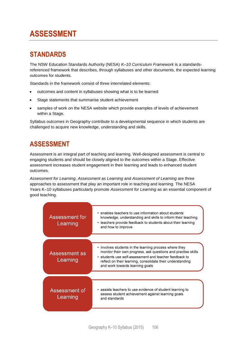
Geography K–10 Syllabus (2015) 106
ASSESSMENT
STANDARDS
The NSW Education Standards Authority (NESA) K–10 Curriculum Framework is a standards-
referenced framework that describes, through syllabuses and other documents, the expected learning
outcomes for students.
Standards in the framework consist of three interrelated elements:
outcomes and content in syllabuses showing what is to be learned
Stage statements that summarise student achievement
samples of work on the NESA website which provide examples of levels of achievement
within a Stage.
Syllabus outcomes in Geography contribute to a developmental sequence in which students are
challenged to acquire new knowledge, understanding and skills.
ASSESSMENT
Assessment is an integral part of teaching and learning. Well-designed assessment is central to
engaging students and should be closely aligned to the outcomes within a Stage. Effective
assessment increases student engagement in their learning and leads to enhanced student
outcomes.
Assessment for Learning, Assessment as Learning and Assessment of Learning are three
approaches to assessment that play an important role in teaching and learning. The NESA
Years K–10 syllabuses particularly promote Assessment for Learning as an essential component of
good teaching.
Geography K–10 Syllabus (2015) 107
Further advice on programming and appropriate assessment practice is provided on the NESA
website. This support material provides general advice on assessment as well as strategies to assist
teachers in planning education programs.
ASSESSMENT FOR STUDENTS WITH DISABILITY
Some students with disability will require adjustments to assessment practices in order to demonstrate
what they know and can do in relation to syllabus outcomes and content. The type of adjustments and
support will vary according to the particular needs of the student and the requirements of the activity.
These may be:
adjustments to the assessment process, for example scaffolded instructions, additional guidance
provided, highlighted key-words or phrases, the use of specific technology, extra time in an
examination
adjustments to assessment activities, for example rephrasing questions, using simplified
language, fewer questions or alternative formats for questions
alternative formats for responses, for example written point form instead of essays, scaffolded
structured responses, short objective questions or multimedia presentations.
It is a requirement under the Disability Standards for Education 2005 for schools to ensure that
assessment tasks are accessible to students with a disability. Schools are responsible for any
decisions made at school level to offer adjustments to coursework, assessment activities and tasks,
including in-school tests. Decisions regarding adjustments should be made in the context of
collaborative curriculum planning.
Further examples of adjustments to assessment for students with disability and information on
assessment of students undertaking Life Skills outcomes and content can be found in support
materials for:
Human Society and its Environment (HSIE)
Special Education
Life Skills.
REPORTING
Reporting is the process of providing feedback to students, parents/carers and other teachers about
student progress.
Teachers use assessment evidence to extend the process of Assessment for Learning into their
Assessment of Learning. In a standards-referenced framework, teachers make professional
judgements about student achievement at key points in the learning cycle. These points may be at the
end of a Year or Stage, when schools may wish to report differentially on the levels of knowledge,
understanding and skills demonstrated by students.
Descriptions of student achievement provide schools with a useful tool to report consistent information
about student achievement to students and parents/carers, and to the next teacher to help plan the
next steps in the learning process.
The A–E grade scale or equivalent provides a common language for reporting by describing
observable and measurable features of student achievement at the end of a Stage, within the
indicative hours of study. Teachers use the descriptions of the standards to make a professional, on-
balance judgement, based on available assessment information, to match each student’s

Geography K–10 Syllabus (2015) 108
achievement to a description. Teachers use the Common Grade Scale (A–E) or equivalent to report
student levels of achievement from Stage 1 to Stage 5.
For students with disability, teachers may need to consider, in consultation with their school and
sector, the most appropriate method of reporting student achievement. It may be deemed more
appropriate for students with disability to be reported against outcomes or goals identified through the
collaborative curriculum planning process. There is no requirement for schools to use the Common
Grade Scale (A–E) or equivalent to report achievement of students undertaking Life Skills outcomes
and content.
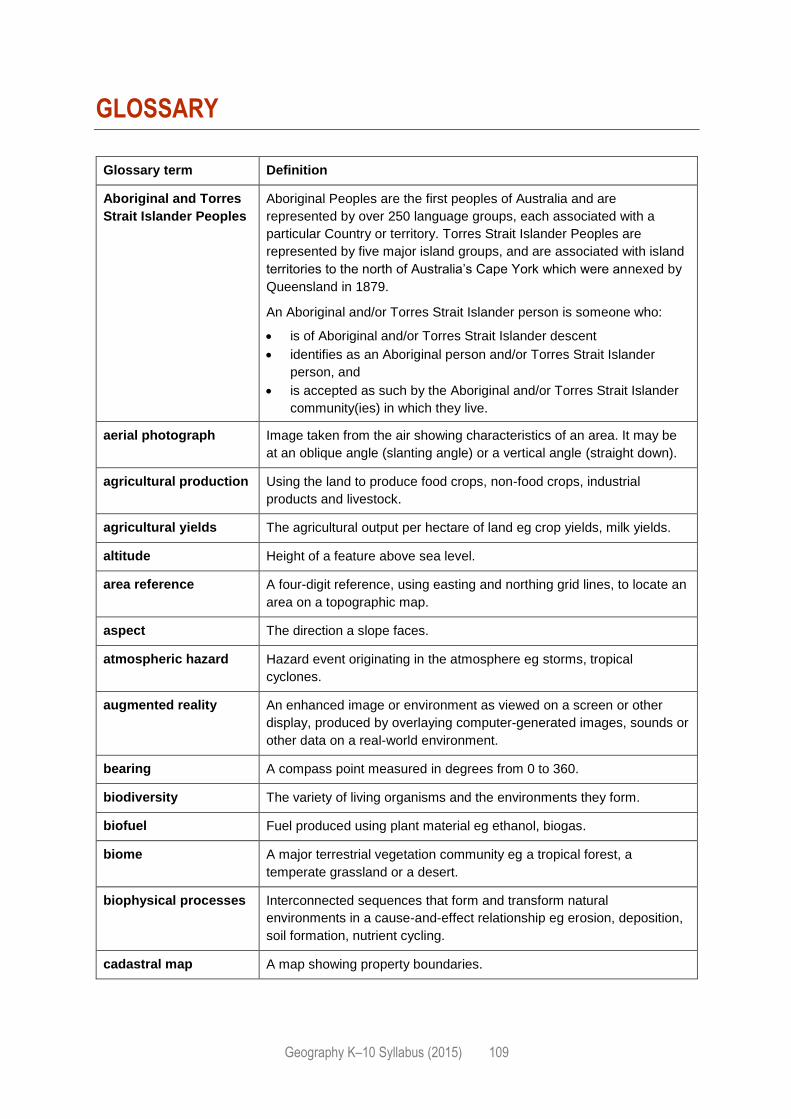
Geography K–10 Syllabus (2015) 109
GLOSSARY
Glossary term Definition
Aboriginal and Torres
Strait Islander Peoples
Aboriginal Peoples are the first peoples of Australia and are
represented by over 250 language groups, each associated with a
particular Country or territory. Torres Strait Islander Peoples are
represented by five major island groups, and are associated with island
territories to the north of Australia’s Cape York which were annexed by
Queensland in 1879.
An Aboriginal and/or Torres Strait Islander person is someone who:
is of Aboriginal and/or Torres Strait Islander descent
identifies as an Aboriginal person and/or Torres Strait Islander
person, and
is accepted as such by the Aboriginal and/or Torres Strait Islander
community(ies) in which they live.
aerial photograph Image taken from the air showing characteristics of an area. It may be
at an oblique angle (slanting angle) or a vertical angle (straight down).
agricultural production Using the land to produce food crops, non-food crops, industrial
products and livestock.
agricultural yields The agricultural output per hectare of land eg crop yields, milk yields.
altitude Height of a feature above sea level.
area reference A four-digit reference, using easting and northing grid lines, to locate an
area on a topographic map.
aspect The direction a slope faces.
atmospheric hazard Hazard event originating in the atmosphere eg storms, tropical
cyclones.
augmented reality An enhanced image or environment as viewed on a screen or other
display, produced by overlaying computer-generated images, sounds or
other data on a real-world environment.
bearing A compass point measured in degrees from 0 to 360.
biodiversity The variety of living organisms and the environments they form.
biofuel Fuel produced using plant material eg ethanol, biogas.
biome A major terrestrial vegetation community eg a tropical forest, a
temperate grassland or a desert.
biophysical processes Interconnected sequences that form and transform natural
environments in a cause-and-effect relationship eg erosion, deposition,
soil formation, nutrient cycling.
cadastral map A map showing property boundaries.
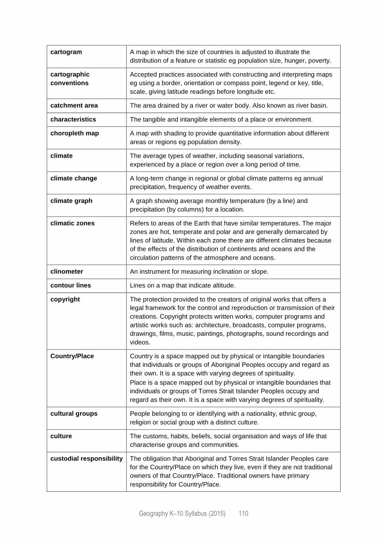
Geography K–10 Syllabus (2015) 110
cartogram A map in which the size of countries is adjusted to illustrate the
distribution of a feature or statistic eg population size, hunger, poverty.
cartographic
conventions
Accepted practices associated with constructing and interpreting maps
eg using a border, orientation or compass point, legend or key, title,
scale, giving latitude readings before longitude etc.
catchment area The area drained by a river or water body. Also known as river basin.
characteristics The tangible and intangible elements of a place or environment.
choropleth map A map with shading to provide quantitative information about different
areas or regions eg population density.
climate The average types of weather, including seasonal variations,
experienced by a place or region over a long period of time.
climate change A long-term change in regional or global climate patterns eg annual
precipitation, frequency of weather events.
climate graph A graph showing average monthly temperature (by a line) and
precipitation (by columns) for a location.
climatic zones Refers to areas of the Earth that have similar temperatures. The major
zones are hot, temperate and polar and are generally demarcated by
lines of latitude. Within each zone there are different climates because
of the effects of the distribution of continents and oceans and the
circulation patterns of the atmosphere and oceans.
clinometer An instrument for measuring inclination or slope.
contour lines Lines on a map that indicate altitude.
copyright The protection provided to the creators of original works that offers a
legal framework for the control and reproduction or transmission of their
creations. Copyright protects written works, computer programs and
artistic works such as: architecture, broadcasts, computer programs,
drawings, films, music, paintings, photographs, sound recordings and
videos.
Country/Place Country is a space mapped out by physical or intangible boundaries
that individuals or groups of Aboriginal Peoples occupy and regard as
their own. It is a space with varying degrees of spirituality.
Place is a space mapped out by physical or intangible boundaries that
individuals or groups of Torres Strait Islander Peoples occupy and
regard as their own. It is a space with varying degrees of spirituality.
cultural groups People belonging to or identifying with a nationality, ethnic group,
religion or social group with a distinct culture.
culture The customs, habits, beliefs, social organisation and ways of life that
characterise groups and communities.
custodial responsibility The obligation that Aboriginal and Torres Strait Islander Peoples care
for the Country/Place on which they live, even if they are not traditional
owners of that Country/Place. Traditional owners have primary
responsibility for Country/Place.
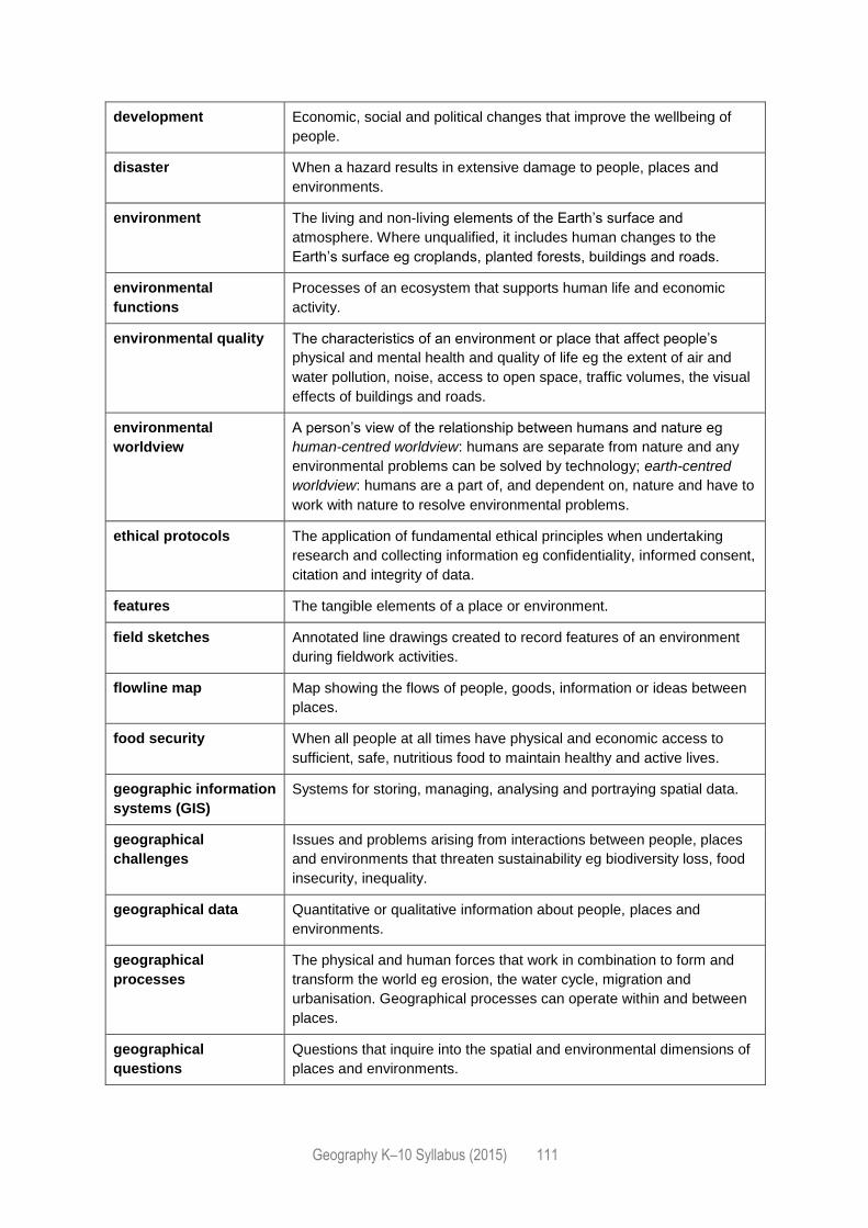
Geography K–10 Syllabus (2015) 111
development Economic, social and political changes that improve the wellbeing of
people.
disaster When a hazard results in extensive damage to people, places and
environments.
environment The living and non-living elements of the Earth’s surface and
atmosphere. Where unqualified, it includes human changes to the
Earth’s surface eg croplands, planted forests, buildings and roads.
environmental
functions
Processes of an ecosystem that supports human life and economic
activity.
environmental quality The characteristics of an environment or place that affect people’s
physical and mental health and quality of life eg the extent of air and
water pollution, noise, access to open space, traffic volumes, the visual
effects of buildings and roads.
environmental
worldview
A person’s view of the relationship between humans and nature eg
human-centred worldview: humans are separate from nature and any
environmental problems can be solved by technology; earth-centred
worldview: humans are a part of, and dependent on, nature and have to
work with nature to resolve environmental problems.
ethical protocols The application of fundamental ethical principles when undertaking
research and collecting information eg confidentiality, informed consent,
citation and integrity of data.
features The tangible elements of a place or environment.
field sketches Annotated line drawings created to record features of an environment
during fieldwork activities.
flowline map Map showing the flows of people, goods, information or ideas between
places.
food security When all people at all times have physical and economic access to
sufficient, safe, nutritious food to maintain healthy and active lives.
geographic information
systems (GIS)
Systems for storing, managing, analysing and portraying spatial data.
geographical
challenges
Issues and problems arising from interactions between people, places
and environments that threaten sustainability eg biodiversity loss, food
insecurity, inequality.
geographical data Quantitative or qualitative information about people, places and
environments.
geographical
processes
The physical and human forces that work in combination to form and
transform the world eg erosion, the water cycle, migration and
urbanisation. Geographical processes can operate within and between
places.
geographical
questions
Questions that inquire into the spatial and environmental dimensions of
places and environments.
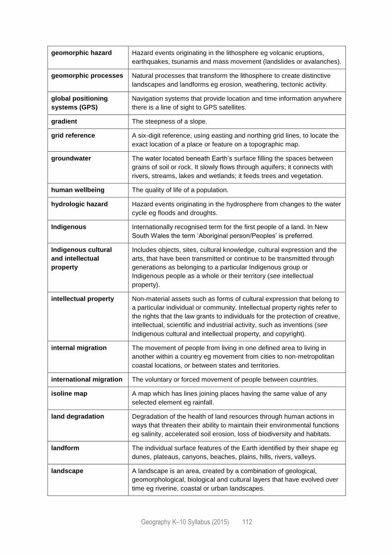
Geography K–10 Syllabus (2015) 112
geomorphic hazard Hazard events originating in the lithosphere eg volcanic eruptions,
earthquakes, tsunamis and mass movement (landslides or avalanches).
geomorphic processes Natural processes that transform the lithosphere to create distinctive
landscapes and landforms eg erosion, weathering, tectonic activity.
global positioning
systems (GPS)
Navigation systems that provide location and time information anywhere
there is a line of sight to GPS satellites.
gradient The steepness of a slope.
grid reference A six-digit reference, using easting and northing grid lines, to locate the
exact location of a place or feature on a topographic map.
groundwater The water located beneath Earth’s surface filling the spaces between
grains of soil or rock. It slowly flows through aquifers; it connects with
rivers, streams, lakes and wetlands; it feeds trees and vegetation.
human wellbeing The quality of life of a population.
hydrologic hazard Hazard events originating in the hydrosphere from changes to the water
cycle eg floods and droughts.
Indigenous Internationally recognised term for the first people of a land. In New
South Wales the term ‘Aboriginal person/Peoples’ is preferred.
Indigenous cultural
and intellectual
property
Includes objects, sites, cultural knowledge, cultural expression and the
arts, that have been transmitted or continue to be transmitted through
generations as belonging to a particular Indigenous group or
Indigenous people as a whole or their territory (see intellectual
property).
intellectual property Non-material assets such as forms of cultural expression that belong to
a particular individual or community. Intellectual property rights refer to
the rights that the law grants to individuals for the protection of creative,
intellectual, scientific and industrial activity, such as inventions (see
Indigenous cultural and intellectual property, and copyright).
internal migration The movement of people from living in one defined area to living in
another within a country eg movement from cities to non-metropolitan
coastal locations, or between states and territories.
international migration The voluntary or forced movement of people between countries.
isoline map A map which has lines joining places having the same value of any
selected element eg rainfall.
land degradation Degradation of the health of land resources through human actions in
ways that threaten their ability to maintain their environmental functions
eg salinity, accelerated soil erosion, loss of biodiversity and habitats.
landform The individual surface features of the Earth identified by their shape eg
dunes, plateaus, canyons, beaches, plains, hills, rivers, valleys.
landscape A landscape is an area, created by a combination of geological,
geomorphological, biological and cultural layers that have evolved over
time eg riverine, coastal or urban landscapes.
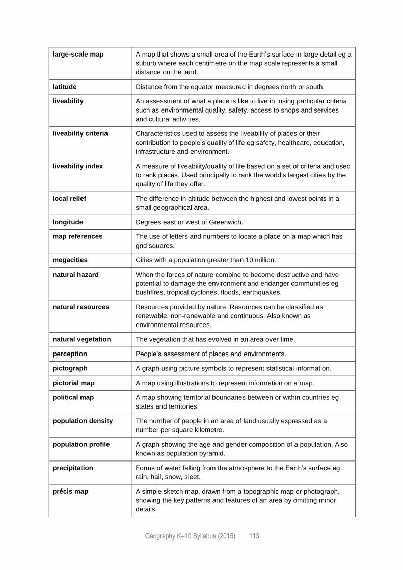
Geography K–10 Syllabus (2015) 113
large-scale map A map that shows a small area of the Earth’s surface in large detail eg a
suburb where each centimetre on the map scale represents a small
distance on the land.
latitude Distance from the equator measured in degrees north or south.
liveability An assessment of what a place is like to live in, using particular criteria
such as environmental quality, safety, access to shops and services
and cultural activities.
liveability criteria Characteristics used to assess the liveability of places or their
contribution to people’s quality of life eg safety, healthcare, education,
infrastructure and environment.
liveability index A measure of liveability/quality of life based on a set of criteria and used
to rank places. Used principally to rank the world’s largest cities by the
quality of life they offer.
local relief The difference in altitude between the highest and lowest points in a
small geographical area.
longitude Degrees east or west of Greenwich.
map references The use of letters and numbers to locate a place on a map which has
grid squares.
megacities Cities with a population greater than 10 million.
natural hazard When the forces of nature combine to become destructive and have
potential to damage the environment and endanger communities eg
bushfires, tropical cyclones, floods, earthquakes.
natural resources Resources provided by nature. Resources can be classified as
renewable, non-renewable and continuous. Also known as
environmental resources.
natural vegetation The vegetation that has evolved in an area over time.
perception People’s assessment of places and environments.
pictograph A graph using picture symbols to represent statistical information.
pictorial map A map using illustrations to represent information on a map.
political map A map showing territorial boundaries between or within countries eg
states and territories.
population density The number of people in an area of land usually expressed as a
number per square kilometre.
population profile A graph showing the age and gender composition of a population. Also
known as population pyramid.
precipitation Forms of water falling from the atmosphere to the Earth’s surface eg
rain, hail, snow, sleet.
précis map A simple sketch map, drawn from a topographic map or photograph,
showing the key patterns and features of an area by omitting minor
details.
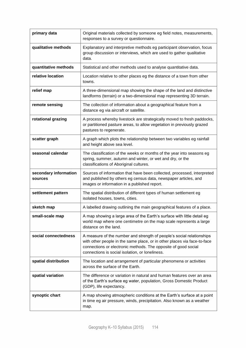
Geography K–10 Syllabus (2015) 114
primary data Original materials collected by someone eg field notes, measurements,
responses to a survey or questionnaire.
qualitative methods
Explanatory and interpretive methods eg participant observation, focus
group discussion or interviews, which are used to gather qualitative
data.
quantitative methods Statistical and other methods used to analyse quantitative data.
relative location Location relative to other places eg the distance of a town from other
towns.
relief map A three-dimensional map showing the shape of the land and distinctive
landforms (terrain) or a two-dimensional map representing 3D terrain.
remote sensing The collection of information about a geographical feature from a
distance eg via aircraft or satellite.
rotational grazing A process whereby livestock are strategically moved to fresh paddocks,
or partitioned pasture areas, to allow vegetation in previously grazed
pastures to regenerate.
scatter graph A graph which plots the relationship between two variables eg rainfall
and height above sea level.
seasonal calendar The classification of the weeks or months of the year into seasons eg
spring, summer, autumn and winter, or wet and dry, or the
classifications of Aboriginal cultures.
secondary information
sources
Sources of information that have been collected, processed, interpreted
and published by others eg census data, newspaper articles, and
images or information in a published report.
settlement pattern The spatial distribution of different types of human settlement eg
isolated houses, towns, cities.
sketch map A labelled drawing outlining the main geographical features of a place.
small-scale map A map showing a large area of the Earth’s surface with little detail eg
world map where one centimetre on the map scale represents a large
distance on the land.
social connectedness A measure of the number and strength of people’s social relationships
with other people in the same place, or in other places via face-to-face
connections or electronic methods. The opposite of good social
connections is social isolation, or loneliness.
spatial distribution The location and arrangement of particular phenomena or activities
across the surface of the Earth.
spatial variation The difference or variation in natural and human features over an area
of the Earth’s surface eg water, population, Gross Domestic Product
(GDP), life expectancy.
synoptic chart A map showing atmospheric conditions at the Earth’s surface at a point
in time eg air pressure, winds, precipitation. Also known as a weather
map.
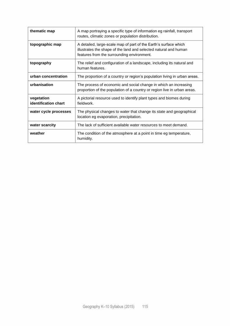
Geography K–10 Syllabus (2015) 115
thematic map A map portraying a specific type of information eg rainfall, transport
routes, climatic zones or population distribution.
topographic map A detailed, large-scale map of part of the Earth’s surface which
illustrates the shape of the land and selected natural and human
features from the surrounding environment.
topography The relief and configuration of a landscape, including its natural and
human features.
urban concentration The proportion of a country or region’s population living in urban areas.
urbanisation The process of economic and social change in which an increasing
proportion of the population of a country or region live in urban areas.
vegetation
identification chart
A pictorial resource used to identify plant types and biomes during
fieldwork.
water cycle processes The physical changes to water that change its state and geographical
location eg evaporation, precipitation.
water scarcity The lack of sufficient available water resources to meet demand.
weather The condition of the atmosphere at a point in time eg temperature,
humidity.