Embed Size (px)
Citation preview

181
The Geological Society of AmericaSpecial Paper 497
2013
Origin of Columbia River Basalt: Passive rise of shallow mantle, or active upwelling of a deep-mantle plume?
Victor E. CampDepartment of Geological Sciences, San Diego State University, San Diego, California 92116, USA
ABSTRACT
The lack of fi eld evidence for signifi cant crustal stretching during the main phase of fl ood basalt eruption rules out a passive-mantle origin for the Columbia River Basalt Group. The short duration (1.1 m.y.) of the main-phase lavas, their large volume (~195,500 km3), and their high eruption rate (~0.178 km3/yr) in an area of minimal extension (<<1%) are better explained by an active-mantle upwelling origin. Such a scenario could be satisfi ed by the arrival of a lower-mantle plume, or by the ascent of upper mantle through a slab gap or around the truncated edge of the Farallon plate. These competing ideas have been based on the interpretation of seismic data beneath the Yellowstone region that appear to resolve either a sheet of mantle upwelling extending downward into the mantle transition zone, or an irregu-lar corridor of upwelling extending through the transition zone and into the lower mantle to ~900–1000 km depth. A lower-mantle origin is supported by the seismically resolved upward defl ection in the ~660 km discontinuity at the base of the transition zone, which in turn is consistent with a lower-mantle chemical signature refl ected in high 3He/4He ratios found in derivative basalts from both the Snake River Plain and the Columbia River fl ood basalt province. Mid-Miocene arrival of the Yellow-stone plume was centered beneath the Oregon-Nevada border region, where there are direct spatial and temporal connections among the initiation of fl ood basalt vol-canism at ca. 16.7 Ma, the initiation of rhyolitic volcanism at the western end of the Snake River Plain hotspot track at ca. 16.5 Ma, and the initiation of a major period of uplift and crustal extension in the northern Basin and Range between ca. 17 and 16 Ma. Rapid uplift and the propagation of volcanism away from this region are con-sistent with models of plume emplacement. The inability of seismic studies to image a mantle-plume fabric of radiating fl ow is due to its destruction by corner fl ow, which is evident in the contemporary east-west fl ow fabric derived from shear-wave split-ting measurements.
Camp, V.E., 2013, Origin of Columbia River Basalt: Passive rise of shallow mantle, or active upwelling of a deep-mantle plume?, in Reidel, S.P., Camp, V.E., Ross, M.E., Wolff, J.A., Martin, B.S., Tolan, T.L., and Wells, R.E., eds., The Columbia River Flood Basalt Province: Geological Society of America Special Paper 497, p. 181–199, doi:10.1130/2013.2497(07). For permission to copy, contact [email protected]. © 2013 The Geological Society of America. All rights reserved.
182 V.E. Camp
INTRODUCTION
In the 1960s, early workers on the Columbia Plateau used fi eld criteria and petrographic characteristics to establish a working stratigraphy through the thick basaltic pile (Mackin, 1961; Waters, 1961; Bond, 1963; Bingham and Walters, 1965; Schmincke, 1967), which was refi ned later by detailed geochemi-cal and paleomagnetic investigations (e.g., Watkins, 1965; Brock and Grolier, 1973; Wright et al., 1973; Nathan and Fruchter, 1974; Swanson et al., 1979; Swanson and Wright, 1981; Reidel, 1983; Hooper et al., 1984). These early studies resulted in the development of a coherent regional stratigraphy, the detail of which was more fully developed in the late 1970s and into the 1980s by a concentrated effort to map the Columbia Plateau at reconnaissance scale (e.g., Swanson et al., 1979, 1980; Camp, 1981; Camp and Hooper, 1981; Swanson et al., 1981; Camp et al., 1982; Tolan et al., 1989). Much of this early work culminated in a series of papers, which were compiled in Geological Society of America Special Paper 239 (Reidel and Hooper, 1989).
While early workers focused their effort on stratigraphically based fi eld investigations, there was less effort devoted toward the publication of comprehensive tectonomagmatic models of fl ood basalt genesis. The fi rst such models attributed the origin of the Columbia River Basalt Group and the Steens Basalt of eastern Oregon to shallow-mantle melting associated with back-arc extension (Carlson and Hart, 1987; Hart and Carlson, 1987; Smith, 1992). Later models suggested that melting in the upper mantle was triggered by torsional stress of the plate interior (Dickinson, 1997; Tikoff et al., 2008), lithospheric delamination (Hales et al., 2005), or more recently, upper-mantle convection through, or around the truncated edge of, the Farallon–Juan de Fuca plate (Sigloch et al., 2008; Faccenna et al., 2010; James et al., 2011; Liu and Stegman, 2012; Long et al., 2012). Although these shallow-mantle models lie contrary to the traditional view that fl ood basalt provinces are generated above plumes derived from the deep mantle (e.g., Morgan, 1972; Campbell, 2005), they are embraced by many who advocate a nonplume origin for all oceanic plateaus, continental fl ood basalt provinces, and hotspot tracks (e.g., Foulger and Natland, 2003; Lustrino, 2005; Anderson, 2005, 2007; Foulger, 2007; comments to Hooper et al., 2007, p. 256–268).
The ongoing debate for or against a mantle-plume origin for continental fl ood basalts requires detailed and well-constrained databases derived from integrated fi eld, geochronological, geo-chemical, and geophysical investigations. Such a comprehensive database is evident for the Columbia River Basalt Group, which has long been regarded as the best preserved and most intensely studied fl ood basalt province on Earth. The majority of workers with direct fi eld experience on the Columbia River fl ood basalt province have favored a plume origin as the most reasonable explanation for its fi eld and petrochemical characteristics (e.g., Duncan, 1982; Brandon and Goles, 1988, 1995; Draper, 1991; Hooper and Hawkesworth, 1993; Geist and Richards, 1993; Camp, 1995; Dodson et al., 1997; Hooper et al., 2002, 2007;
Camp et al., 2003; Camp and Ross, 2004; Camp and Hanan, 2008; Wolff et al., 2008; Wolff and Ramos, this volume). Such a model is supported by seismic data that appear to resolve a contemporary plume conduit beneath Yellowstone National Park at the eastern end of the Snake River Plain hotspot track (e.g., Yuan and Dueker, 2005; Waite et al., 2006; Smith et al., 2009; Obrebski et al., 2010; Humphreys and Schmandt, 2011; Tian and Zhao, 2012; Darold and Humphreys, 2013). Other workers have questioned the validity of a plume origin in favor of a variety of nonplume interpretations (e.g., Roth et al., 2008; Warren et al., 2008; Faccenna et al., 2010; Long et al., 2012; James et al., 2011; Fouch, 2012; Liu and Stegman, 2012).
The wealth of geologic data on the Columbia River Basalt Group is not only integral to the specifi c debate on its origin (Hooper et al., 2007), but also to the broader debate on the very existence of mantle plumes (e.g., DePaolo and Manga, 2003; Anderson, 2007; Foulger, 2007). A discussion on the origin of these fl ood basalts would therefore seem timely and relevant to fellow workers and interested readers of this volume. The intent of this chapter is to provide an updated summary on the geo-logical and geophysical data used to evaluate genetic models, and to discuss the effi cacy of various proposed models that include passive-mantle upwelling associated with crustal extension and active-mantle upwelling associated with both plume and non-plume interpretations.
SPATIAL AND TEMPORAL CONNECTION WITH THE YELLOWSTONE MANTLE PLUME
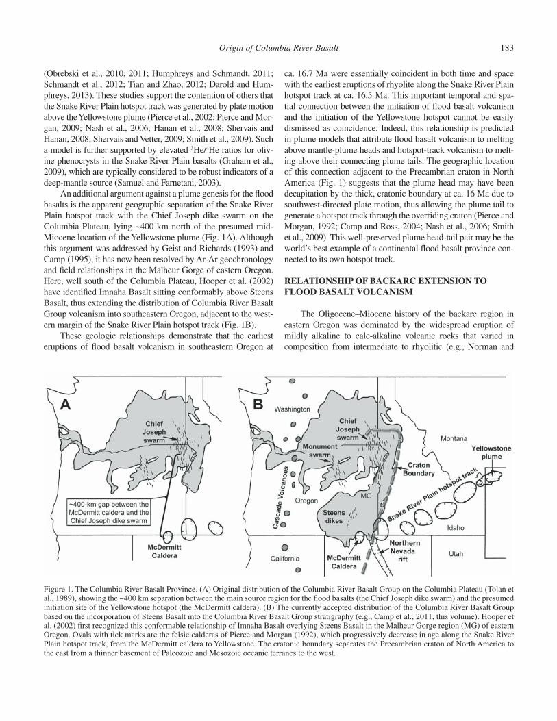
The only obvious candidate for a plume source for the Colum-bia River Basalt Group is the plume-like upwelling that currently underlies Yellowstone National Park, located at the northeastern end of the Snake River Plain hotspot track (Fig. 1). Pierce and Morgan (1992) noted that the hotspot track is delineated by a series of calderas and rhyolitic centers that become progressively older to the southwest, consistent with the southwestern migra-tion of the North American plate over a relatively stationary Yel-lowstone plume. Such migration would have placed the Yellow-stone plume near the Nevada-Oregon-Idaho tri-state area in the mid-Miocene, in an area that would include the McDermitt and related calderas, where the initial hotspot eruptions of rhyolite began at ca. 16.5 Ma (Rytuba and McKee, 1984; Swisher et al., 1990; Henry et al., 2006; Colgan et al., 2006; Brueseke et al., 2007; Jarboe et al., 2007, 2008; Coble and Mahood, 2012).
One of the primary rationalizations for dismissing a plume genesis for the Columbia River Basalt Group and the Snake River Plain had been the failure of seismic studies to identify a mantle anomaly extending >200 km beneath Yellowstone National Park (Iyer et al., 1981; Evans, 1982; Dueker and Humphreys, 1994; Christiansen et al., 2002; Schutt and Humphreys, 2004). Later tomographic studies, however, have defi ned a mantle plume beneath Yellowstone extending to a depth of at least 500 km (Yuan and Dueker, 2005; Waite et al., 2006; Smith et al., 2009; Xue and Allen, 2010), and more recently to a depth of 900–1000 km
Origin of Columbia River Basalt 183
(Obrebski et al., 2010, 2011; Humphreys and Schmandt, 2011; Schmandt et al., 2012; Tian and Zhao, 2012; Darold and Hum-phreys, 2013). These studies support the contention of others that the Snake River Plain hotspot track was generated by plate motion above the Yellowstone plume (Pierce et al., 2002; Pierce and Mor-gan, 2009; Nash et al., 2006; Hanan et al., 2008; Shervais and Hanan, 2008; Shervais and Vetter, 2009; Smith et al., 2009). Such a model is further supported by elevated 3He/4He ratios for oliv-ine phenocrysts in the Snake River Plain basalts (Graham et al., 2009), which are typically considered to be robust indicators of a deep-mantle source (Samuel and Farnetani, 2003).
An additional argument against a plume genesis for the fl ood basalts is the apparent geographic separation of the Snake River Plain hotspot track with the Chief Joseph dike swarm on the Columbia Plateau, lying ~400 km north of the presumed mid-Miocene location of the Yellowstone plume (Fig. 1A). Although this argument was addressed by Geist and Richards (1993) and Camp (1995), it has now been resolved by Ar-Ar geochronology and fi eld relationships in the Malheur Gorge of eastern Oregon. Here, well south of the Columbia Plateau, Hooper et al. (2002) have identifi ed Imnaha Basalt sitting conformably above Steens Basalt, thus extending the distribution of Columbia River Basalt Group volcanism into southeastern Oregon, adjacent to the west-ern margin of the Snake River Plain hotspot track (Fig. 1B).
These geologic relationships demonstrate that the earliest eruptions of fl ood basalt volcanism in southeastern Oregon at
ca. 16.7 Ma were essentially coincident in both time and space with the earliest eruptions of rhyolite along the Snake River Plain hotspot track at ca. 16.5 Ma. This important temporal and spa-tial connection between the initiation of fl ood basalt volcanism and the initiation of the Yellowstone hotspot cannot be easily dismissed as coincidence. Indeed, this relationship is predicted in plume models that attribute fl ood basalt volcanism to melting above mantle-plume heads and hotspot-track volcanism to melt-ing above their connecting plume tails. The geographic location of this connection adjacent to the Precambrian craton in North America (Fig. 1) suggests that the plume head may have been decapitation by the thick, cratonic boundary at ca. 16 Ma due to southwest-directed plate motion, thus allowing the plume tail to generate a hotspot track through the overriding craton (Pierce and Morgan, 1992; Camp and Ross, 2004; Nash et al., 2006; Smith et al., 2009). This well-preserved plume head-tail pair may be the world’s best example of a continental fl ood basalt province con-nected to its own hotspot track.
RELATIONSHIP OF BACKARC EXTENSION TO FLOOD BASALT VOLCANISM
The Oligocene–Miocene history of the backarc region in eastern Oregon was dominated by the widespread eruption of mildly alkaline to calc-alkaline volcanic rocks that varied in composition from intermediate to rhyolitic (e.g., Norman and
Figure 1. The Columbia River Basalt Province. (A) Original distribution of the Columbia River Basalt Group on the Columbia Plateau (Tolan et al., 1989), showing the ~400 km separation between the main source region for the fl ood basalts (the Chief Joseph dike swarm) and the presumed initiation site of the Yellowstone hotspot (the McDermitt caldera). (B) The currently accepted distribution of the Columbia River Basalt Group based on the incorporation of Steens Basalt into the Columbia River Basalt Group stratigraphy (e.g., Camp et al., 2011, this volume). Hooper et al. (2002) fi rst recognized this conformable relationship of Imnaha Basalt overlying Steens Basalt in the Malheur Gorge region (MG) of eastern Oregon. Ovals with tick marks are the felsic calderas of Pierce and Morgan (1992), which progressively decrease in age along the Snake River Plain hotspot track, from the McDermitt caldera to Yellowstone. The cratonic boundary separates the Precambrian craton of North America to the east from a thinner basement of Paleozoic and Mesozoic oceanic terranes to the west.
184 V.E. Camp
Leeman, 1990; Langer, 1991; Mathis, 1993; Dooley, 2010), and that were in places bimodal (e.g., Colgan et al., 2006; Lerch et al., 2008). Although volcanically active at least since the early Oli-gocene, tholeiitic volcanism did not begin in the backarc region until the mid-Miocene, when this long-lived tectonic regime underwent an abrupt, but short-lived (~1.1 m.y.) transformation, manifested by the main-phase eruptions of the Columbia River Basalt Group from ca. 16.7 Ma to ca. 15.6 Ma (Barry et al., 2010, this volume; Camp et al., this volume). These uninterrupted, tho-leiitic eruptions continued over at least six paleomagnetic inter-vals to form the voluminous succession of the Steens, Imnaha, Grande Ronde, and Picture Gorge Basalts.
All workers agree that these eruptions occurred in a back-arc environment, but they disagree on whether backarc extension was the sole contributor to fl ood basalt genesis. Some suggest an origin associated with the passive rise of ambient-temperature mantle driven by either backarc extension or delamination, while others suggest that fl ood basalt volcanism is an active-mantle process driven by the rapid upwelling of a plume-like body con-taining anomalously hot and/or fertile mantle.
Crustal Extension and the Passive Rise of Shallow Mantle
Several workers have invoked shallow-mantle melting mod-els for the origin of the Columbia River Basalt Group. Most of these involve the passive, adiabatic rise and melting of astheno-spheric mantle that would result from either backarc extension (e.g., Carlson and Hart, 1987; Smith, 1992) or transtensional shear of the plate interior (Dickinson, 1997; Tikoff et al., 2008). The exception to these stress-release models is that of Hales et al. (2005), who suggested that the Columbia River Basalt Group originated from the passive rise of asthenosphere into the void created by delamination of lithosphere beneath the Chief Joseph dike swarm. This model, however, does not accord with the numerical experiments of Elkins-Tanton (2007), who demon-strated that even under the most extreme conditions of delami-nation, the rise of ambient-temperature asthenosphere cannot generate the large melt volumes associated with fl ood basalt vol-canism. In addition, localized delamination at the Chief Joseph dike swarm cannot account for the more widespread eruptions of the Columbia River Basalt Group that occurred as far west as the Monument dike swarm in north-central Oregon and as far south as the Steens Basalt dike swarm in southeastern Oregon and adja-cent Nevada (Fig. 1).
On the other hand, the numerical experiments of Burov and Guillou-Frottier (2005) and Burov et al. (2007) demonstrated that delamination of the lithospheric mantle and lower crust is the expected result of plume emplacement. In testing this active-mantle process, Camp and Hanan (2008) showed that a plume-triggered delamination origin for the Columbia River Basalt Group appears to be consistent with the sequence of source melting evident in the basalt stratigraphy, and with the history of uplift and tectonism in eastern Oregon and adjacent Washington. More recently, Darold and Humphreys (2013) presented a similar
scenario where fl ood-basalt volcanism was induced by plume-triggered delamination of the remnant Farallon plate beneath northeastern Oregon.
The extent to which regional crustal stretching provides the driving mechanism for mantle melting is an important consid-eration in nonplume models of fl ood-basalt volcanism. There is little or no evidence to suggest that Columbia River Basalt Group volcanism was associated with signifi cant extension other than the minor amount of stretching necessary for dike injection (<<1%). In southeastern Oregon, the greatest amount of Mio-cene extension occurred between ca. 15.5 Ma and 10.5 Ma to produce the Oregon-Idaho graben (Cummings et al., 2000). This rift zone is associated with relatively small-volume eruptions of basaltic, andesitic, and rhyolitic lava, typically of calc-alkaline to mildly alkaline affi nity (Hooper et al., 2002). After ca. 12 Ma, a later period of extension generated the western Snake River Plain (Wood and Clemens, 2002) and the fault-block mountain ranges that defi ne the northern Basin and Range Province (Colgan et al., 2006). All of these mid- to late Miocene regions of crustal stretching postdate the voluminous, largely tholeiitic eruptions of Steens Basalt at ca. 16.7 Ma (Camp et al., this volume). Similarly, in northeastern Oregon and southeastern Washington, where ~90% of the Columbia River Basalt Group erupted from the Chief Joseph dike swarm, there is a distinct lack of exten-sional features occurring at the same time as fl ood basalt eruption (Wells, 1990; Hooper et al., 2007).
On the other hand, Colgan and Henry (2009) have shown that the northern Basin and Range Province experienced 40%–50% extension that began abruptly at ca. 16–17 Ma, in an area of very minor basalt volcanism. These fi eld relationships demon-strate that the area of least extension generated the greatest vol-ume of basaltic lava from the Chief Joseph dike swarm, and that the area of greatest extension generated only minor volcanism. The eruption of such large volumes of basalt in the absence of substantial crustal rifting, and the lack of signifi cant volcanism in the presence of considerable rifting are inconsistent with the pas-sive rise of mantle driven by crustal extension (e.g., McKenzie and Bickle, 1988).
Active-Mantle Upwelling in the Absence of Signifi cant Extension
The revised total volume generated by the main-phase eruptions is 195,500 km3, or ~93% of the total Columbia River Basalt Group volume, which equates to an overall effusion rate of 0.178 km3/yr. The peak effusion rate was generated during the initial stage of fl ood basalt volcanism, when the majority of the Steens Basalt lavas (~31,800 km3) erupted in <50,000 yr at a rate of ~0.67 km3/yr (Camp et al., 2011, this volume). The brief dura-tion (~1.1 m.y.), high effusion rate, and homogeneity of the main-phase tholeiites lie in stark contrast to the much longer history of intermittent, and compositionally more variable, eruptions that have been more typical of the Oregon backarc region since early Oligocene time.
Origin of Columbia River Basalt 185
Columbia River Basalt Group volcanism thus appears to have been a singular event in the history of eastern Oregon and adjacent Washington, distinguished by voluminous eruptions that generated Earth’s only obvious example of a fl ood basalt prov-ince located in a backarc setting. Long-lived backarc extension cannot by itself account for this dramatic burst of basalt accu-mulation during the main-phase eruptions. An additional compo-nent of active-mantle upwelling would seem to be required, and workers have proposed both shallow- and deep-mantle processes. Faccenna et al. (2010), James et al. (2011), and Liu and Steg-man (2012), for example, suggested that active-mantle upwelling beneath the Columbia River Basalt Group source region could have resulted from small-scale convection in the upper mantle along tears in, or around the edges of the truncated Farallon–Juan de Fuca plate. Long et al. (2012) promoted a similar model facili-tated by a rapid initiation of slab rollback. The more traditional view suggests that the generation of such large volumes of fl ood basalt over an exceedingly short interval of time, during minimal extension, is better explained by the arrival of a thermal and/or fertile anomaly from the deep mantle (e.g., White and McKen-zie, 1989, 1995). Whatever its origin, the most reasonable choice for this anomalous mantle is the seismically resolved plume-like body that currently resides beneath Yellowstone National Park (Waite et al., 2006; Obrebski et al., 2010, 2011; Humphreys and Schmandt, 2011; Schmandt et al., 2012), as demonstrated by plate reconstruction, which places it in the vicinity of fl ood basalt volcanism at ca. 16.5 Ma, contemporaneous with the initiation of fl ood basalt volcanism (Pierce and Morgan, 1992, 2009; Pierce et al., 2002; Shervais and Hanan, 2008; Smith et al., 2009).
Propagation of Flood Basalt Volcanism: A Passive or Active Mantle?
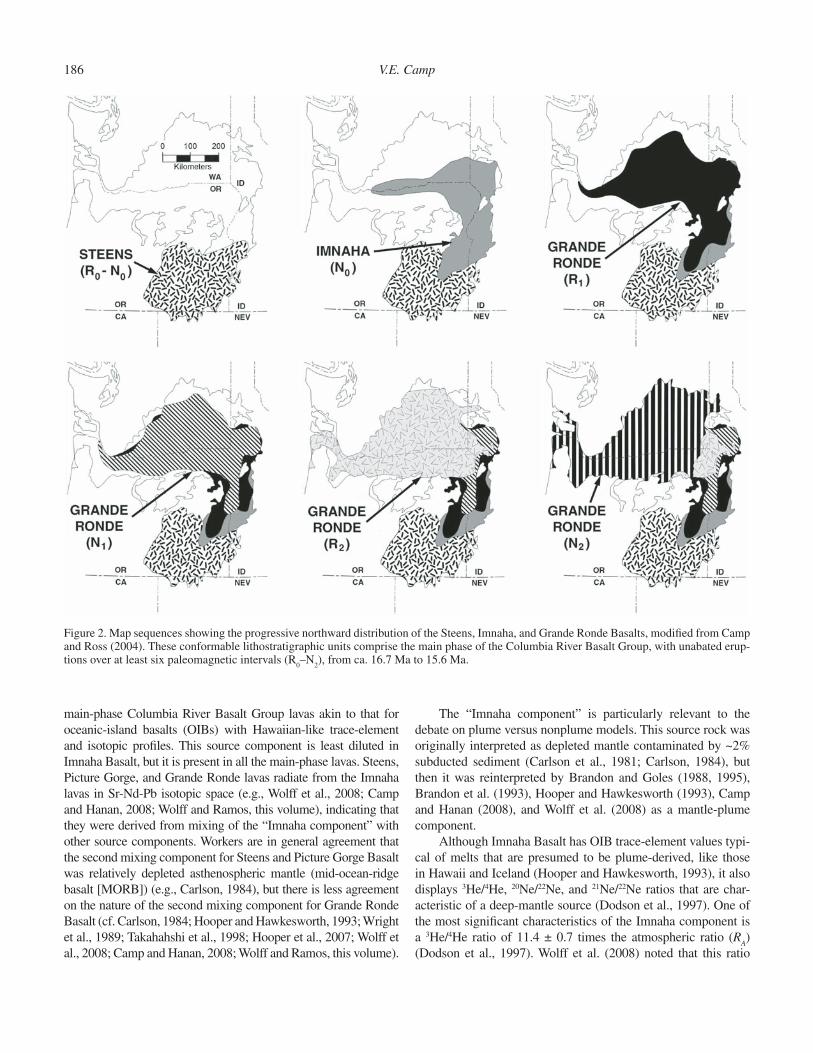
Field data demonstrate a rapid northward propagation of dike intrusion and fl ood basalt volcanism from southeastern Ore-gon and into southeastern Washington during the Columbia River Basalt Group main-phase eruptions (Fig. 2). The early eruptions of Steens Basalt in southeastern Oregon were followed by the eruption of Imnaha Basalt farther to the north in the vicinity of the Malheur Gorge. Northward migration continued into the Chief Joseph dike swarm, where Imnaha Basalt was followed by the progressive advance of each of the four magnetostratigraphic units that comprise Grande Ronde Basalt (Fig. 2) (Camp and Ross, 2004). A distance of ~450 km can be measured between the geographic center of the oldest Steens eruptions in southeast Oregon (i.e., magnetostratigraphic unit R
0) to the center of the
youngest Grande Ronde eruptions in southeast Washington (i.e., magnetostratigraphic unit N
2). That distance equates to an aver-
age migration rate of ~0.4 m/yr over the ~1.1 m.y. interval of the main-phase eruptions. This rate is over four times the average migration rate of propagating hotspots (Wang and Wang, 2001), but it is similar to the ~0.2–0.3 m/yr rate predicted in model sim-ulations of a relatively small, outwardly spreading plume head impinging on lithospheric mantle (d’Acremont et al., 2003).
Realistic models of Columbia River Basalt Group volca-nism must be able to account for this rapid rate of basalt propa-gation. One potential mechanism is to attribute the migration of eruptive activity to passive-mantle rise beneath a northward-propagating rift system. Such a model, however, is inconsistent with the fi eld evidence and the complete absence of coeval rift-related structures in the fl ood basalt source region. Indeed, none of the proposed models for passive-mantle upwelling driven by backarc extension or delamination can adequately explain this northward migration.
Camp (1995) attributed the rapid propagation of volcanism to an active-mantle explanation associated with an outwardly spreading plume head that was deformed against the thick cratonic boundary of North America. In this interpretation, a balloon-like mass would have impinged on the lithosphere and fl attened outward. The greatest volume of the plume head would have spread rapidly and preferentially to the north, against the craton, fl owing “uphill” into the thin lithosphere of accreted oce-anic terranes that form the basement rocks of northeastern Ore-gon. Rapid propagation of the plume head into this “thinspot” (Thompson and Gibson, 1991) would have resulted in a massive melting event manifested on the surface by a northward migra-tion of dike injection and fl ood basalt eruption from southeast Oregon and into the Chief Joseph and Monument dike swarms (Camp and Ross, 2004; Camp and Hanan, 2008).
Farther south, plume impingement beneath the thicker cratonic-to-transitional lithosphere of northern Nevada was man-ifested in a different manner. Here, the abrupt and contemporane-ous onset of Basin and Range extension at ca. 16–17 Ma (Colgan and Henry, 2009) may well have been induced by plume emplace-ment, but the surface expression of magmatism was minor, in the form of small-volume volcanic fi elds, dike injection, and aero-magnetic anomalies representing keel dikes associated with the northern Nevada rift system (Glen and Ponce, 2002).
Alternative models for northward migration include (1) subslab fl ow through a northward propagating tear in the Farallon plate (Liu and Stegman, 2012), (2) similar subslab fl ow around the truncated edge of the Farallon plate during slab roll-back (Long et al., 2012), or (3) rapid propagation of Imnaha and Grande Ronde dikes driven outward by a high magma fl ux rate from a centralized magma chamber located at the northwestern end of the western Snake River Plain (Wolff and Ramos, this vol-ume). Liu and Stegman (2012) and Long et al. (2012) envision a shallow-mantle genesis, while Wolff and Ramos (this volume) present chemical evidence for a deeper-mantle plume with a component from the lower mantle. All of these alternative mod-els are consistent with active-mantle upwelling being the root cause of voluminous melting.
GEOCHEMICAL EVIDENCE FOR A DEEP-MANTLE SOURCE
Brandon and Goles (1988, 1995) and Hooper and Hawkes-worth (1993) identifi ed a primary mantle source component in the
186 V.E. Camp
main-phase Columbia River Basalt Group lavas akin to that for oceanic-island basalts (OIBs) with Hawaiian-like trace-element and isotopic profi les. This source component is least diluted in Imnaha Basalt, but it is present in all the main-phase lavas. Steens, Picture Gorge, and Grande Ronde lavas radiate from the Imnaha lavas in Sr-Nd-Pb isotopic space (e.g., Wolff et al., 2008; Camp and Hanan, 2008; Wolff and Ramos, this volume), indicating that they were derived from mixing of the “Imnaha component” with other source components. Workers are in general agreement that the second mixing component for Steens and Picture Gorge Basalt was relatively depleted asthenospheric mantle (mid-ocean-ridge basalt [MORB]) (e.g., Carlson, 1984), but there is less agreement on the nature of the second mixing component for Grande Ronde Basalt (cf. Carlson, 1984; Hooper and Hawkesworth, 1993; Wright et al., 1989; Takahahshi et al., 1998; Hooper et al., 2007; Wolff et al., 2008; Camp and Hanan, 2008; Wolff and Ramos, this volume).
The “Imnaha component” is particularly relevant to the debate on plume versus nonplume models. This source rock was originally interpreted as depleted mantle contaminated by ~2% subducted sediment (Carlson et al., 1981; Carlson, 1984), but then it was reinterpreted by Brandon and Goles (1988, 1995), Brandon et al. (1993), Hooper and Hawkesworth (1993), Camp and Hanan (2008), and Wolff et al. (2008) as a mantle-plume component.
Although Imnaha Basalt has OIB trace-element values typi-cal of melts that are presumed to be plume-derived, like those in Hawaii and Iceland (Hooper and Hawkesworth, 1993), it also displays 3He/4He, 20Ne/22Ne, and 21Ne/22Ne ratios that are char-acteristic of a deep-mantle source (Dodson et al., 1997). One of the most signifi cant characteristics of the Imnaha component is a 3He/4He ratio of 11.4 ± 0.7 times the atmospheric ratio (R
A)
(Dodson et al., 1997). Wolff et al. (2008) noted that this ratio
Figure 2. Map sequences showing the progressive northward distribution of the Steens, Imnaha, and Grande Ronde Basalts, modifi ed from Camp and Ross (2004). These conformable lithostratigraphic units comprise the main phase of the Columbia River Basalt Group, with unabated erup-tions over at least six paleomagnetic intervals (R
0–N
2), from ca. 16.7 Ma to 15.6 Ma.
Origin of Columbia River Basalt 187
is signifi cantly elevated compared with MORB (3He/4He = 8 ± 1 R
A), and equivalent to the “moderately high 3He/4He” OIB type
of Class and Goldstein (2005) in its Pb isotope and incompatible element abundances. The most reasonable mechanism to account for the elevated 3He/4He in the Imnaha component is a plume derived from the deep mantle (Dodson et al., 1997; Hooper et al., 2007; Wolff et al., 2008; Camp and Hanan, 2008). A causal relationship between the Imnaha component and the Yellowstone plume is further suggested by similar elevated 3He/4He values for younger basalts lying along the Snake River Plain hotspot track (Graham et al., 2009), which have maintained a direct connec-tion to the plume currently underlying Yellowstone National Park (Yuan and Dueker, 2005; Waite et al., 2006; Obrebski et al., 2010).
UPLIFT ABOVE THE MANTLE-PLUME HEAD
Active-mantle models of plume impingement predict that uplift above the plume head will begin before the eruption of continental fl ood basalts (Campbell and Griffi ths, 1990; Hill et al., 1992; White and McKenzie, 1995). Such uplift is evident at the site of the Chief Joseph dike swarm, in the border region of northeast Oregon and Idaho, where deep canyons that cut through the prebasalt surface were fi lled with the earliest fl ows of Imnaha Basalt (Kleck, 1976; Hooper et al., 1984, 2007). Con-tinued uplift during the main-phase eruptions is manifested in the northward offl ap of basalt units resulting from the progressive rise of a north-dipping paleoslope (Camp, 1995). This northward migration of uplift was coincident in both time and space with the northward migration of volcanism from southeast Oregon into southeast Washington (Camp and Ross, 2004). Pierce et al. (2002) described this region as the northern part of a much broader region of plume-generated uplift. They presented 13 lines of evidence for the development of a large north-south dome, the crest of which extended for ~1000 km, from the southern tip of the northern Nevada rift system in the south to the Chief Joseph and Monument dike swarms in the north. Such uplift is consistent with U-Pb data on paleodrainages (Beranek et al., 2006) and with paleobotanical altitude estimates supporting the development of a broad precipitation shadow to the east that peaked at ca. 15 Ma (Pierce et al., 2002). In the northern part of the dome, this abrupt period of uplift was contemporaneous with dike injection and fl ood basalt volcanism during a time of minimal extension, all of which are consistent with an active-mantle process, and which are equally inconsistent with stress-release models driven by con-tinental extension.
The fi eld data suggest that uplift was initiated by a thermal anomaly that arrived at asthenospheric depths in the early to mid-Miocene, thus reducing the density of the overlying lithosphere. In addition to thermal uplift, continued isostatic support for the uplifted region was maintained by the associated melting event, which gen-erated voluminous basalt and restite, both of which have lower den-sities than the original mantle source (Morgan et al., 1995).
Today, the southern portion of the uplifted dome in north-central Nevada has experienced ~40%–50% extension since
ca. 17 Ma (Colgan and Henry, 2009). If this region was under-lain by normal-temperature mantle, then even small degrees of extension should result in continental subsidence (White and Mc Kenzie, 1989, 1995). Although such a scenario of mid-Miocene extension and subsidence has indeed been argued by Colgan and Henry (2009), the northern Basin and Range still maintains a relatively high elevation (1.0–1.5 km) for such a highly extended terrain. Its buoyancy is evident in progressively decreasing altitudes from the northern to the southern Basin and Range Province, which Saltus and Thompson (1995) attributed to the isostatic support of the remnant Yellowstone plume. In an independent investigation, Parsons et al. (1994) used crustal thickness and density constraints to model a residual mass defi cit in the mantle beneath the northern Basin and Range, which they also attributed to emergence of the Yellowstone mantle plume at ca. 17 Ma. A more recent tomographic study attributes the buoy-ancy of this uplifted region to a broad, low-velocity anomaly refl ecting high temperatures in the upper mantle, consistent with a plume origin (Yang et al., 2008).
LOCATION OF PLUME IMPINGEMENT
The three most commonly cited locations for the center of the plume head are, from south to north: (1) in the vicinity of the McDermitt caldera on the Oregon-Nevada border (Pierce and Morgan, 1992; Zoback et al., 1994; Parsons et al., 1994; Pierce et al., 2002), (2) in southeastern Oregon, ~80 km north of the McDermitt caldera (Ernst and Buchan, 2001; Camp and Ross, 2004; Pierce and Morgan, 2009), and (3) near Vale, Oregon, at the western edge of the western Snake River Plain graben, ~240 km north of the McDermitt caldera (Glen and Ponce, 2002; Shervais and Hanan, 2008; Wolff et al., 2008) (Fig. 3).
In modeling the ascending plume head as a spherical mass, Pierce and Morgan (2009) estimated its diameter at ~300 km. Once it impinged and spread out at the base of the lithosphere, even such a small plume head would have generated a very wide area of uplift and volcanism. Thus, small discrepancies in deter-mining the exact location of the plume center may not be sig-nifi cant. Nevertheless, the large distance between the Vale and McDermitt locations is signifi cant, and determining the more likely center of plume impingement has some important tectono-magmatic implications.
Smith et al. (2009) utilized several parameters in modeling the ascent of the Yellowstone plume over time. They noted that the orientation and age progression along the hotspot track depend on the difference vector between plate motion and mantle fl ow at source depth, but the largest uncertainties in measuring mantle fl ow arise from variations in mantle density models. Thus, Smith et al. (2009) used several density variations in their model experi-ments, along with variations in source depth, both at 660 km and in the lower mantle. Their models demonstrate that if the Yellow-stone plume originated in the lower mantle and arrived at the base of the lithosphere at ca. 15 Ma, its location will vary depending on which density variations are used. When extrapolating the model
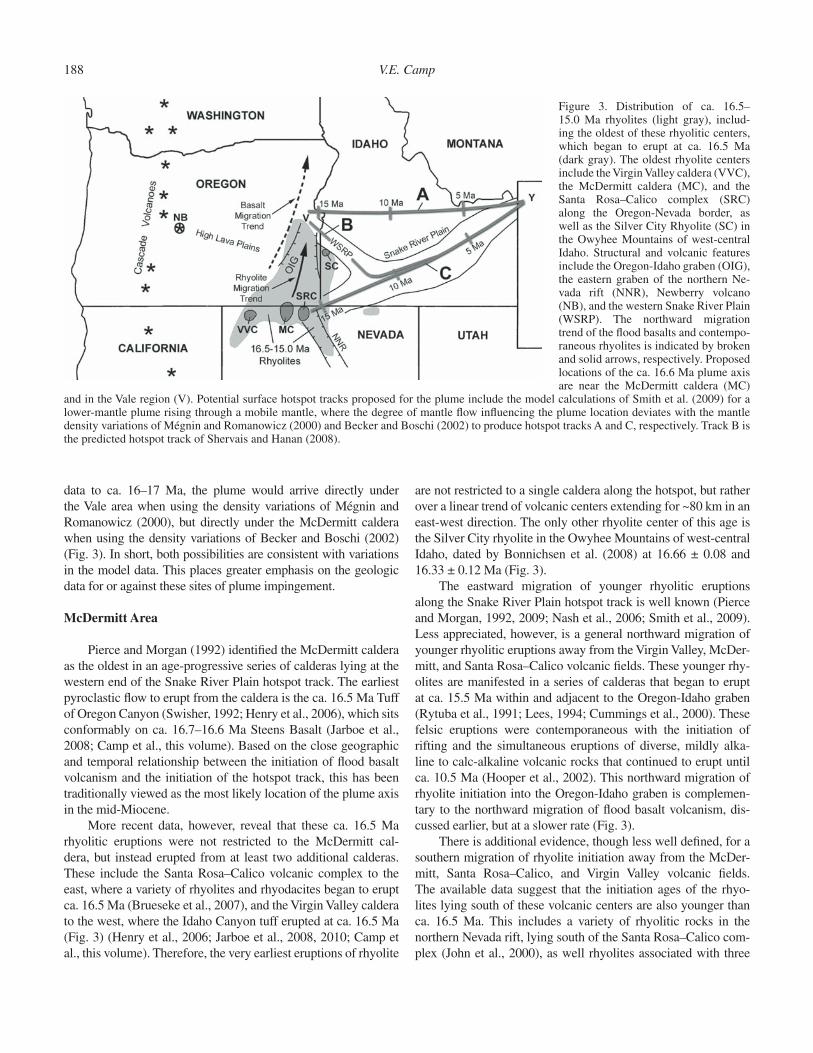
188 V.E. Camp
data to ca. 16–17 Ma, the plume would arrive directly under the Vale area when using the density variations of Mégnin and Romanowicz (2000), but directly under the McDermitt caldera when using the density variations of Becker and Boschi (2002) (Fig. 3). In short, both possibilities are consistent with variations in the model data. This places greater emphasis on the geologic data for or against these sites of plume impingement.
McDermitt Area
Pierce and Morgan (1992) identifi ed the McDermitt caldera as the oldest in an age-progressive series of calderas lying at the western end of the Snake River Plain hotspot track. The earliest pyroclastic fl ow to erupt from the caldera is the ca. 16.5 Ma Tuff of Oregon Canyon (Swisher, 1992; Henry et al., 2006), which sits conformably on ca. 16.7–16.6 Ma Steens Basalt (Jarboe et al., 2008; Camp et al., this volume). Based on the close geographic and temporal relationship between the initiation of fl ood basalt volcanism and the initiation of the hotspot track, this has been traditionally viewed as the most likely location of the plume axis in the mid-Miocene.
More recent data, however, reveal that these ca. 16.5 Ma rhyolitic eruptions were not restricted to the McDermitt cal-dera, but instead erupted from at least two additional calderas. These include the Santa Rosa–Calico volcanic complex to the east, where a variety of rhyolites and rhyodacites began to erupt ca. 16.5 Ma (Brueseke et al., 2007), and the Virgin Valley caldera to the west, where the Idaho Canyon tuff erupted at ca. 16.5 Ma (Fig. 3) (Henry et al., 2006; Jarboe et al., 2008, 2010; Camp et al., this volume). Therefore, the very earliest eruptions of rhyolite
are not restricted to a single caldera along the hotspot, but rather over a linear trend of volcanic centers extending for ~80 km in an east-west direction. The only other rhyolite center of this age is the Silver City rhyolite in the Owyhee Mountains of west-central Idaho, dated by Bonnichsen et al. (2008) at 16.66 ± 0.08 and 16.33 ± 0.12 Ma (Fig. 3).
The eastward migration of younger rhyolitic eruptions along the Snake River Plain hotspot track is well known (Pierce and Morgan, 1992, 2009; Nash et al., 2006; Smith et al., 2009). Less appreciated, however, is a general northward migration of younger rhyolitic eruptions away from the Virgin Valley, McDer-mitt, and Santa Rosa–Calico volcanic fi elds. These younger rhy-olites are manifested in a series of calderas that began to erupt at ca. 15.5 Ma within and adjacent to the Oregon-Idaho graben (Rytuba et al., 1991; Lees, 1994; Cummings et al., 2000). These felsic eruptions were contemporaneous with the initiation of rifting and the simultaneous eruptions of diverse, mildly alka-line to calc-alkaline volcanic rocks that continued to erupt until ca. 10.5 Ma (Hooper et al., 2002). This northward migration of rhyolite initiation into the Oregon-Idaho graben is complemen-tary to the northward migration of fl ood basalt volcanism, dis-cussed earlier, but at a slower rate (Fig. 3).
There is additional evidence, though less well defi ned, for a southern migration of rhyolite initiation away from the McDer-mitt, Santa Rosa–Calico, and Virgin Valley volcanic fi elds. The available data suggest that the initiation ages of the rhyo-lites lying south of these volcanic centers are also younger than ca. 16.5 Ma. This includes a variety of rhyolitic rocks in the northern Nevada rift, lying south of the Santa Rosa–Calico com-plex (John et al., 2000), as well rhyolites associated with three
Figure 3. Distribution of ca. 16.5–15.0 Ma rhyolites (light gray), includ-ing the oldest of these rhyolitic centers, which began to erupt at ca. 16.5 Ma (dark gray). The oldest rhyolite centers include the Virgin Valley caldera (VVC), the McDermitt caldera (MC), and the Santa Rosa–Calico complex (SRC) along the Oregon-Nevada border, as well as the Silver City Rhyolite (SC) in the Owyhee Mountains of west- central Idaho. Structural and volcanic features include the Oregon-Idaho graben (OIG), the eastern graben of the northern Ne-vada rift (NNR), Newberry volcano (NB), and the western Snake River Plain (WSRP). The northward migration trend of the fl ood basalts and contempo-raneous rhyolites is indicated by broken and solid arrows, respectively. Proposed locations of the ca. 16.6 Ma plume axis are near the McDermitt caldera (MC)
and in the Vale region (V). Potential surface hotspot tracks proposed for the plume include the model calculations of Smith et al. (2009) for a lower-mantle plume rising through a mobile mantle, where the degree of mantle fl ow infl uencing the plume location deviates with the mantle density variations of Mégnin and Romanowicz (2000) and Becker and Boschi (2002) to produce hotspot tracks A and C, respectively. Track B is the predicted hotspot track of Shervais and Hanan (2008).

Origin of Columbia River Basalt 189
recently identifi ed calderas located south of the Virgin Valley cal-dera (Ach and Swisher, 1990; Coble and Mahood, 2012). The oldest pyroclastic fl ow yet identifi ed from these three calderas is the ca. 16.3 Ma Summit Lake tuff (Noble, 2009; Coble and Mahood, 2012), which directly overlies the ca. 16.5 Ma Idaho Canyon tuff of the Virgin Valley caldera (Noble et al., 1970; Coble and Mahood, 2012). Thus, the available data suggest that the Virgin Valley, McDermitt, and Santa Rosa–Calico volcanic centers represent a relatively restricted initiation site for rhyolite volcanism at ca. 16.5 Ma, which not only migrated to the east along the Snake River Plain, but also to the north, and perhaps to the south, with advancing time.
Vale Area
An alternative center for plume impingement was suggested by Glen and Ponce (2002) at the northwestern tip of the western Snake River Plain, north of Vale, Oregon (Fig. 3). They based this location on a regional pattern of geologic and geophysical features that include a radiating system of aeromagnetic anoma-lies, dike swarms, faults, and fold axes. Glen and Ponce (2002) used a Coulomb stress model to show that the convergence of these features is consistent with a point source of stress at the base of the crust, superimposed on the regional stress fi eld. They further suggested that both the radiating features and the point source of stress may be related to the emergence of the Yellow-stone hotspot.
Shervais and Hanan (2008) expanded on this idea by sug-gesting that the plume tail feeding the plume head in the Vale area was forced beneath thinned cratonic lithosphere due to plate motion, bending to the southeast into a preexisting zone of thin lithosphere to produce a thermally eroded lithospheric sink. Once this lithospheric channel was fully established by ca. 12 Ma, rift-ing and rhyolitic volcanism on the surface resulted in the initiation of the western Snake River Plain and massive rhyolitic eruption of the Bruneau-Jarbidge volcanic center lying at the intersec-tion of the western and eastern Snake River Plain (Shervais and Hanan, 2008). Vertical bending of the plume tail required by this model provides an elegant explanation for the current ~65° north-westerly plunge of the plume tail at Yellowstone National Park (Yuan and Dueker, 2005). On the other hand, the current dip of the plume tail can also be explained by variations in the vector of plate motion and the vector of mantle fl ow at source depth, as described by Smith et al. (2009), or by plume-slab interaction, as suggested by Obrebski et al. (2010).
A source for plume-derived melts in the Vale area is also consistent with the model of Wolff et al. (2008) and Wolff and Ramos (this volume), who suggested that the main-phase erup-tions of Columbia River fl ood basalt were derived from a cen-tralized crustal magma chamber located at the northwestern tip of the western Snake River Plain. They presented geochemical evidence that the Steens, Imnaha, and Picture Gorge lavas were generated from the interaction of the plume with surrounding upper mantle, and that the more-evolved Grande Ronde lavas
were generated in this area from the assimilation of cratonic crust by plume-derived melts. They further suggested that the wide-spread eruption of these magmas, in particular, the Imnaha and Grande Ronde magmas, is best explained by lateral transport from radiating dikes derived from this centralized crustal stor-age system. Although this model appears to be consistent with the radiating structures recognized by Glen and Ponce (2002), Wolff et al. (2008) were quick to point out that the location of this centralized crustal storage system does not necessarily place constraints on the location of the plume axis.
Discussion on the Plume Axis
The intriguing scenario of the plume center arriving in the Vale area has some important tectonic implications, particularly with respect to the formation of the western Snake River Plain (Shervais and Hanan, 2008). Before such an interpretation can be accepted whole-heartedly, however, a number of inconsistencies in the geologic data must fi rst be resolved.
The geologic features found above mantle-plume heads are evident in both model simulations and actual examples. The tem-perature at the plume center is thought to be 300 °C ± 100 °C hotter than at the plume margins (McKenzie and Bickle, 1988). Such an environment should generate large degrees of partial melting, manifested on the surface by the signifi cant accumula-tion of basaltic lava (Campbell, 2005). This is certainly true of the Icelandic plume, where seismic data in the North Atlantic demonstrate that the basalt accumulation is thickest at the plume axis but thins signifi cantly toward the plume margins (Hopper et al., 2003). A similar pattern is shown for continental fl ood basalt provinces, exemplifi ed by the plume axis of the Deccan basalts in the western Ghats region of India, where the basaltic pile is >2 km thick (Mahoney, 1988).
In comparison, there are few dikes exposed at the presumed plume center in the Vale area, and a dearth of Columbia River Basalt Group fl ows exposed in only a few isolated outcrops (Walker, 1977). The thickest accumulation of basalt occurs north of Vale, where the majority of Imnaha and Grande Ronde Basalts erupted from the Chief Joseph dike swarm, and south of Vale, where the majority of Steens Basalts erupted from dikes that are best exposed at Steens Mountain. One explanation for this appar-ent lack of volcanism in the Vale region is that the plume center was a region of central uplift where the basalts accumulated in an annulus of lower elevation to the north and south (Shervais and Hanan, 2008), but this explanation does not appear to explain the paucity of eruption sites above the plume axis. Plume-generated uplift is certainly evident, as described earlier herein; however, others have argued that uplift above the plume head is more likely to affect a much broader region (Hooper and Camp, 1981; Camp, 1995; Pierce et al., 2002; Pierce and Morgan, 2009; Hooper et al., 2007), and it is unlikely to be restricted to a relatively small area above the axis of the plume.
The temperature excess at the plume center should not only produce high-volume eruptions, but also the earliest eruptions
190 V.E. Camp
(Campbell, 2005). Such early eruptions are not present in the Vale area. Instead, the oldest volcanic rocks associated with impinge-ment of the Yellowstone plume are the ca. 16.7 Ma Steens Basalt, which erupted in southeastern Oregon, and the ca. 16.5 Ma rhyolites that erupted near the Oregon-Nevada border (Fig. 3). Such early, bimodal eruptions appear to be more common above plume centers, as demonstrated by the Oligocene bimodal erup-tions associated with the Yemen and Ethiopian traps, for example (Peate et al., 2005). Although the location of these bimodal rocks near the Oregon-Nevada border region (Fig. 3) gives credence to this being the initial site of plume impingement, Shervais and Hanan (2008) presented an alternative interpretation that the rhy-olites in this region resulted from lithospheric delamination at the southern margin of the spreading plume head.
Spreading of the plume head away from the site of initial impingement should result in the propagation of volcanism away from the plume axis. At fi rst glance, this seems consistent with the rapid northward migration of volcanism into the Chief Joseph dike swarm (e.g., Camp, 1995; Shervais and Hanan, 2008; Wolff et al., 2008). However, there is no evidence of a complementary southward migration of volcanism away from the Vale region. Instead, northward migration of volcanism into the Chief Joseph dike swarm is only part of a broader migration of volcanism that began in southeastern Oregon, where the oldest fl ood basalts reside (i.e., the ca. 16.7 Ma Steens Basalt), and advanced north-ward through the Vale region (Fig. 3) (Camp and Ross, 2004; Camp and Hanan, 2008). A similar northward migration is evi-dent in the rhyolitic eruptions that migrated northward from the ca. 16.5 Ma rhyolitic centers along the Oregon-Nevada border to the younger rhyolites exposed in the vicinity of the Oregon-Idaho graben, as described earlier herein (Fig. 3).
The location of the plume axis will be a topic of continued debate. To summarize, the idea of the plume axis arriving in the Vale region is an intriguing possibility and cannot be readily dis-carded, but stratigraphic evidence seems to favor a plume axis centered either in the McDermitt area, where the initial rhyolites were generated at ca. 16.5 Ma from crustal melting by plume-derived magmas, or in southeastern Oregon, where fl ood basalt volcanism was initiated at ca. 16.7 Ma.
RECENT GEOPHYSICAL STUDIES AND INTERPRETATIONS
Several recent papers have unveiled a wealth of new geo-physical data for the Pacifi c Northwest; these include (1) new information on the dimensions and seismic structure of the man-tle, obtained from the EarthScope USArray and several other regional networks (Xue and Allen, 2007, 2010; Sigloch et al., 2008; Burdick et al., 2008; Warren et al., 2008; Roth et al., 2008; Wagner et al., 2010; Schmandt and Humphreys, 2011; Obrebski et al., 2010, 2011; James et al., 2011; Schmandt et al., 2012; Tian and Zhao, 2012; Darold and Humphreys, 2013), (2) the structure of the crust and uppermost mantle, revealed in studies using ambi-ent noise and earthquake tomography (Yang et al., 2008; Gao
et al., 2011; Eagar et al., 2011; Hanson-Hedgcock et al., 2012), (3) the mantle-fl ow pattern beneath eastern Oregon, obtained from shear-wave splitting measurements (Xue and Allen, 2006; Long et al., 2009, 2012), (4) the depth and dimensions of the presumed tail of the Yellowstone mantle plume, derived from large-scale magnetotelluric data (Zhdanov et al., 2011) and a variety of seismic surveys (Yuan and Dueker, 2005; Waite et al., 2006; Smith et al., 2009; Obrebski et al., 2010; Humphreys and Schmandt, 2011; Schmandt et al., 2012; Tian and Zhao, 2012), (5) electrical conductivity images of magma beneath the Snake River Plain (Kelbert et al., 2012), and (6) new data on crustal temperatures in the western United States, unveiled by heat-fl ow measurements combined with the spectral analysis of magnetic anomalies (Bouligand et al., 2009).
There has been a lack of agreement among geophysicists on whether these new data support or refute a plume genesis for vol-canism in the Pacifi c Northwest. On one hand, there is growing support for a deep conduit or sheet of mantle upwelling beneath Yellowstone National Park, but there is less direct support for the mid-Miocene emplacement of a mantle-plume head beneath the Oregon-Idaho-Nevada tristate area. The latter is understand-able in light of the diffi culty that geophysical studies have in rec-ognizing past events, particularly after ~16 m.y. of plate motion and mantle fl ow. Genetic models must therefore rely more on the fi eld and geochemical evidence for or against plume emplace-ment. Nevertheless, these geophysical studies provide new and important insight into the mantle dynamics associated with development of the Columbia River Basalt Group, the Snake River Plain, and the Yellowstone hotspot.
Yellowstone Plume Tail and the Snake River Plain
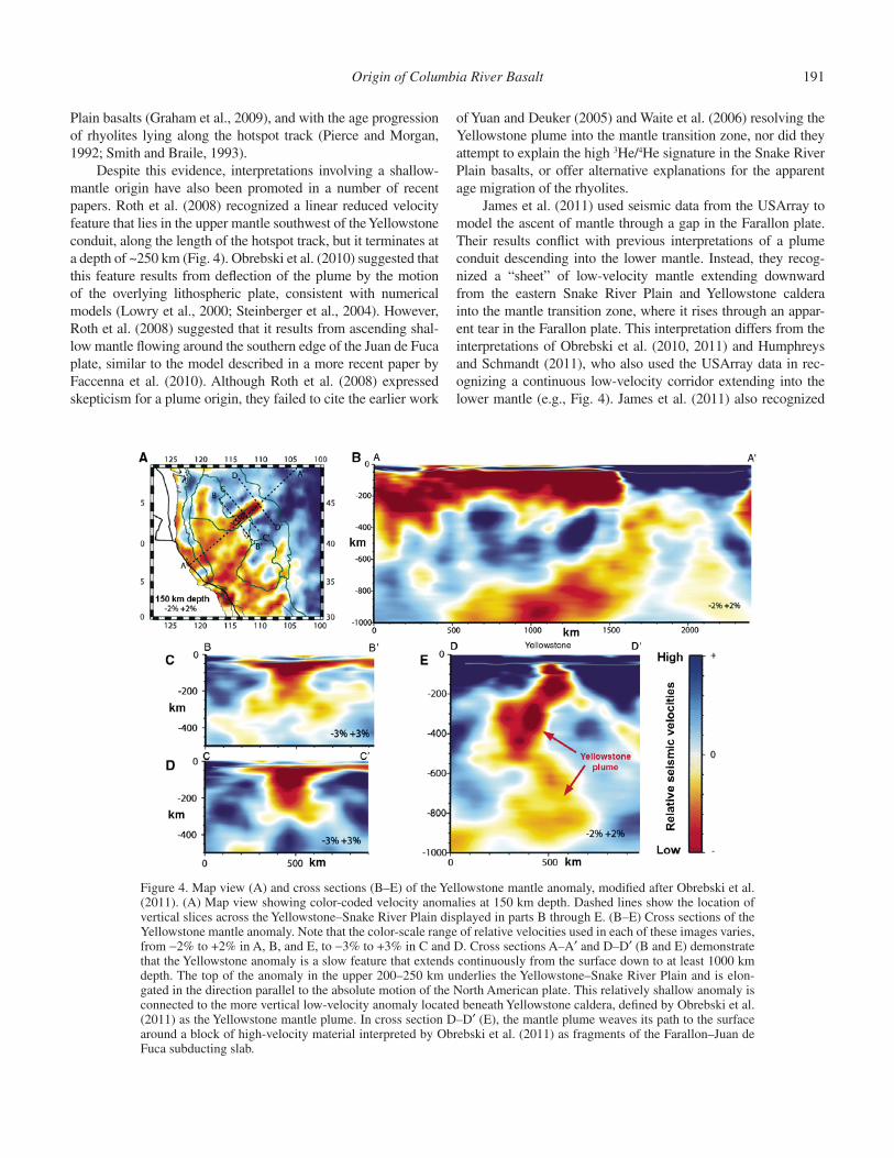
Origin of the Snake River Plain hotspot track by plume-plate interaction has been a long-held view (e.g., Smith and Sbar, 1974; Smith, 1977; Pierce and Morgan, 1992), but acceptance of this model was tempered by the apparent lack of credible seis-mic evidence for a deep-mantle plume (e.g., Christiansen et al., 2002). A low P-wave anomaly into the mantle transition zone beneath Yellowstone was fi rst imaged by Bijwaard et al. (1998) and Montelli et al. (2004), but it was defi ned more precisely by Yuan and Dueker (2005) and Waite et al. (2006) as a low-density plume extending to at least 500 km. The most recent imagery, however, appears to resolve this low-velocity conduit as a con-tinuous, S-shaped, mantle plume that descends into the lower mantle beneath Yellowstone to depth of at least 900–1000 km (Fig. 4) (Obrebski et al., 2010, 2011; Humphreys and Schmandt, 2011; Schmandt et al., 2012; Tian and Zhao, 2012).
The rapidly evolving seismic data add credence to the notion of a contemporary deep-mantle source for the Yellowstone hotspot. By extension, there appears to be a growing consensus among many to endorse a plume origin for the Snake River Plain (Nash et al., 2006; Hanan et al., 2008; Shervais and Hanan, 2008; Pierce and Morgan, 2009; Shervais and Vetter, 2009; Smith et al., 2009), consistent with the high 3He/4He ratios for the Snake River
Origin of Columbia River Basalt 191
Plain basalts (Graham et al., 2009), and with the age progression of rhyolites lying along the hotspot track (Pierce and Morgan, 1992; Smith and Braile, 1993).
Despite this evidence, interpretations involving a shallow-mantle origin have also been promoted in a number of recent papers. Roth et al. (2008) recognized a linear reduced velocity feature that lies in the upper mantle southwest of the Yellowstone conduit, along the length of the hotspot track, but it terminates at a depth of ~250 km (Fig. 4). Obrebski et al. (2010) suggested that this feature results from defl ection of the plume by the motion of the overlying lithospheric plate, consistent with numerical models (Lowry et al., 2000; Steinberger et al., 2004). However, Roth et al. (2008) suggested that it results from ascending shal-low mantle fl owing around the southern edge of the Juan de Fuca plate, similar to the model described in a more recent paper by Faccenna et al. (2010). Although Roth et al. (2008) expressed skepticism for a plume origin, they failed to cite the earlier work
of Yuan and Deuker (2005) and Waite et al. (2006) resolving the Yellowstone plume into the mantle transition zone, nor did they attempt to explain the high 3He/4He signature in the Snake River Plain basalts, or offer alternative explanations for the apparent age migration of the rhyolites.
James et al. (2011) used seismic data from the USArray to model the ascent of mantle through a gap in the Farallon plate. Their results confl ict with previous interpretations of a plume conduit descending into the lower mantle. Instead, they recog-nized a “sheet” of low-velocity mantle extending downward from the eastern Snake River Plain and Yellowstone caldera into the mantle transition zone, where it rises through an appar-ent tear in the Farallon plate. This interpretation differs from the interpretations of Obrebski et al. (2010, 2011) and Humphreys and Schmandt (2011), who also used the USArray data in rec-ognizing a continuous low-velocity corridor extending into the lower mantle (e.g., Fig. 4). James et al. (2011) also recognized
Figure 4. Map view (A) and cross sections (B–E) of the Yellowstone mantle anomaly, modifi ed after Obrebski et al. (2011). (A) Map view showing color-coded velocity anomalies at 150 km depth. Dashed lines show the location of vertical slices across the Yellowstone–Snake River Plain displayed in parts B through E. (B–E) Cross sections of the Yellowstone mantle anomaly. Note that the color-scale range of relative velocities used in each of these images varies, from −2% to +2% in A, B, and E, to −3% to +3% in C and D. Cross sections A–A′ and D–D′ (B and E) demonstrate that the Yellowstone anomaly is a slow feature that extends continuously from the surface down to at least 1000 km depth. The top of the anomaly in the upper 200–250 km underlies the Yellowstone–Snake River Plain and is elon-gated in the direction parallel to the absolute motion of the North American plate. This relatively shallow anomaly is connected to the more vertical low-velocity anomaly located beneath Yellowstone caldera, defi ned by Obrebski et al. (2011) as the Yellowstone mantle plume. In cross section D–D′ (E), the mantle plume weaves its path to the surface around a block of high-velocity material interpreted by Obrebski et al. (2011) as fragments of the Farallon–Juan de Fuca subducting slab.

192 V.E. Camp
a lower-mantle anomaly but suggested that it is separated from their upper-mantle anomaly by the remnant Farallon plate. They acknowledged, however, that their model may be associated with multiple processes, which could include the complementary par-ticipation of lower-mantle upwelling.
In a more recent paper, Schmandt et al. (2012) used the USArray data to image the mantle transition zone discontinuity beneath the irregular zone of low-velocity mantle underlying the Yellowstone caldera. They found that where this mantle anomaly crosses the transition zone, the 660 km discontinuity is warped upward ~12–18 km, as expected from the rise of a thermal plume through the transition zone (Bina and Helffrich, 1994). They therefore concluded that the Yellowstone low-velocity corridor cannot be explained by the passive rise of mantle through the slab edge (Roth et al., 2008; Faccenna et al., 2010) or a gap (James et al., 2011) in the Farallon plate, but instead it represents a lower-mantle plume descending to at least 900 km depth, with tempera-tures that exceed average mantle temperatures near the 660 km discontinuity by ~200–300 K.
Plume Interaction with the Juan de Fuca Plate
There has been much speculation that the starting plume head may have encountered and broken through the subducting Juan de Fuca plate during its Miocene ascent to the base of the lithosphere (Geist and Richards, 1993; Pierce et al., 2002; Camp and Hanan, 2006; Xue and Allen, 2007). Major disruption of the slab by plume interaction should be evident in seismic tomogra-phy models for the Pacifi c Northwest. Roth et al. (2008) inter-preted their seismic data as showing a consistent slab to depths of at least 500 km, with no evidence of plume disruption. In con-trast, other workers conclude that the Juan de Fuca plate beneath Oregon terminates abruptly at ~400 km (Xue and Allen, 2007, 2010) or ~300 km (Obrebski et al., 2010) due to its mid-Miocene destruction by the rising Yellowstone plume. These workers also noted that the timing of plume-plate interaction corresponded closely with a substantial change in the rate of plate motion at ca. 19 Ma (Wilson, 1988) and with the initiation of Columbia River Basalt Group volcanism at ca. 17 Ma.
Plume-plate interaction is also consistent with the substan-tial fragmentation of the slab, including “holes” or breaks in the slab noted by Sigloch et al. (2008), Burdick et al. (2008), and Schmandt and Humphreys (2010). However, Sigloch et al. (2008) preferred to interpret these apparent breaks as tears between two slab segments that allowed buoyant upper mantle lying beneath the slab to rise through it unimpeded, thus melt-ing to generate the Columbia River fl ood basalts. In contrast, Roth et al. (2008) suggested that these “holes” do not exist but instead are inversion artifacts resulting from low-velocity mate-rial lying above the Juan de Fuca plate. The geodynamic model of Liu and Stegman (2012), however, suggests that fl ood basalt volcanism could have been triggered by tearing of the Farallon plate followed by its thermal erosion by upwelling subslab asthe-nosphere. On the other hand, the rapid northward migration of
upper mantle described in the slab-rollback model of Long et al. (2012) requires a coherent Farallon plate, and thus Long et al. (2012) argued in support of the interpretation of Roth et al. (2008) that such breaks or tears do not exist.
Despite these different interpretations, all of the recent tomographic models show a well-defi ned, broken, and imbri-cated pattern in the southern part of the slab, where the Gorda plate descends beneath northernmost California in two en ech-elon slab segments (Roth et al., 2008; Xue and Allen, 2007, 2010; Schmandt and Humphreys, 2010; Obrebski et al., 2010). Roth et al. (2008) noted that the timing of this break would have occurred at ca. 16–17 Ma at current subduction rates, contemporaneous with Columbia River Basalt Group volcanism. Both Roth et al. (2008) and Schmandt and Humphreys (2010) attributed these detached slabs to rapid plate reorganization. In contrast, Obreb-ski et al. (2010) suggested that the break occurred during plume impact, thus isolating the broken, upper fragment from the rest of the plate, which continued to subduct behind it.
In summary, the currently available seismic data beneath Oregon have been interpreted in different ways. Whereas Sigloch et al. (2008) and Roth et al. (2008) saw no evidence for the exis-tence of a mid-Miocene plume or its interaction with the Juan de Fuca plate, other workers have imaged an unexpectedly shal-low termination of the Juan de Fuca plate and signifi cant dis-ruption of the Gorda plate, consistent with the predicted ages of plume interaction, plate reorganization, and the initiation of Columbia River Basalt Group volcanism (Xue and Allen, 2007, 2010; Obrebski et al., 2010). These studies neither prove nor dis-prove a plume origin for the Columbia River Basalt Group. An oceanic slab that has been segmented and highly fragmented by plate reorganization could produce signifi cant changes in mantle fl ow between slab segments, perhaps delivering enough heat to the base of the lithosphere to generate basaltic volcanism on the surface (e.g., Faccenna et al., 2010), and such fl ow should be enhanced by slab rollback (Long et al., 2012). On the other hand, plume interaction provides a convenient mechanism by which to disrupt and fragment the oceanic slab. Whatever the cause of fragmentation, a broken and segmented slab removes one of the primary arguments often cited against a plume origin—that the subducting lithosphere would have been an impenetrable barrier to mantle-plume rise.
Dispersion of the Mantle-Plume Head
While the Yellowstone plume tail seems well established as a mantle anomaly, seismic studies have greater diffi culty resolv-ing the location and dimensions of the presumed plume head responsible for Columbia River Basalt Group volcanism. Yang et al. (2008) utilized recent innovations in ambient noise and earthquake tomography to reveal a broad low-velocity anomaly beneath southern Oregon and the northern Basin and Range Province at depths above ~120 km. Such an anomaly would be consistent with the location of the plume head, as envisioned by Saltus and Thompson (1995) and Parsons et al. (1994). Indeed,
Origin of Columbia River Basalt 193
Yang et al. (2008) agreed that this anomaly is plume derived, but more likely derived from contemporary plume-fed astheno-spheric fl ow (Yamamoto et al., 2007) with its source from the Yellowstone plume tail. If true, then any attempt to seismically resolve a remnant plume head after ~16–17 m.y. of mantle fl ow should prove particularly diffi cult.
A rather consistent orientation of mantle fl ow appears to be recorded in the shear-wave splitting results of Long et al. (2009), who measured fast directions in southeastern Oregon that are predominantly E-W, mostly ranging from ~N80°E to N100°W. They concluded that this mantle fabric is inconsistent with plume models, where fl ow alignment should radiate outward from the plume axis. They also noted that this mantle fabric is not from relict anisotropy “frozen” in the lithospheric mantle, but instead it refl ects contemporary mantle fl ow in the asthenosphere. If true, then this fl ow must be decoupled from the southwest motion of the overlying lithospheric plate. There are numerous potential mechanisms to account for E-W fl ow of the asthenosphere in this region, many of which are outlined by Jordan (2005). Whatever the cause, the prevailing direction of mantle fl ow would have cer-tainly altered or destroyed any original pattern of anisotropy that might have been created during the time of plume emplacement at ca. 16–17 Ma.
The mantle fabric identifi ed by Long et al. (2009) is consis-tent with the model of Jordan et al. (2004), who suggested that the effects of asthenospheric fl ow and counterfl ow above the sub-ducting plate would have driven the plume head westward, thus reorienting its mineral fabric. Camp and Ross (2004) suggested that heat loss from the plume head during this westward advance may have resulted in melting of the overlying mantle lithosphere, thus producing the high-alumina olivine tholeiites common to eastern Oregon (Hart et al., 1984). Underplating of basaltic melts is the most likely contributor to crustal melting and the related bimodal volcanism along the High Lava Plains trend (Fig. 3). The westward advance of crustal melts rising preferentially into weakened crust of the northwest-trending Brothers fault zone may have generated the pattern of progressively younger rhyo-litic eruptions along the Oregon High Lava Plains trend (Jordan et al., 2004).
Camp and Ross (2004) suggested that the northwest migra-tion of these rhyolites may be an indirect manifestation of a much broader, westward migration of the plume head. Yang et al. (2008) suggested that westward fl ow in this region continues to be fed by the Yellowstone plume tail. Such a model is consis-tent with (1) a pattern of low-velocity anomalies in the mantle that spreads outward from the Snake River Plain into Oregon and northern Nevada to the western margin of the Cascade Range (Xue and Allen, 2010), and (2) a geographically identical pattern of abnormally elevated temperature and heat-fl ow measurements in the shallow crust (Bouligand et al., 2009, their fi gure 12c).
The backarc region adjacent to the southern Cascades is underlain by abnormally hot mantle delineated by a seismic low-velocity zone that extends from northern Nevada to southern Washington (Xue and Allen, 2010). Roth et al. (2008) and Xue
and Allen (2010) demonstrated that the most anomalous part of this N-S belt is a large region of strongly reduced P-wave veloci-ties beneath the Newberry volcano (Fig. 3) to ~300 km depth, with a lateral dimension that extends northward into southern Washington. There are several alternative explanations for this thermal anomaly: (1) subslab asthenosphere rising from beneath the shallow end of the abruptly terminated Juan de Fuca plate (Obrebski et al., 2010); (2) a remnant of the mid-Miocene plume head dispersed to the west by the prevailing westward fl ow (Xue and Allen, 2010); or (3) subslab fl ow around the southern edge of the Juan de Fuca plate, focused to the west by slab rollback (Long et al., 2012).
A primary, enriched plume source for basaltic rocks lying along the Newberry (High Lava Plains) trend is ruled out by the chemical data. Instead, these high-alumina olivine tholeiites have moderately low 3He/4He ratios, between 7.6 and 9.3 R
A
(Graham et al., 2009), and trace-element compositions indica-tive of a depleted upper-mantle source (Carlson and Hart, 1988). Carlson et al. (2009) suggested that source melting beneath the Newberry volcano (Fig. 3) was infl uenced by fl uids derived from the subducting slab. While such fl uids would have certainly been a catalyst for melt generation by lowering the melting tempera-ture of the source, they may not have played the primary role in mantle melting. Roth et al. (2008) noted that this large anomaly almost certainly has a strong thermal component, so that abnor-mally high temperatures of the source would just as certainly have been a major contributor to mantle melting. This is consis-tent with a dispersed plume remnant with elevated temperatures suffi cient enough to melt hydrated mantle in the backarc region, but it is also consistent with the adiabatic rise and melting of subslab asthenosphere through, or around the edge of, the Juan de Fuca plate.
CONCLUSIONS
Regional models describing the genesis of the Columbia River Basalt Group must be consistent with the following con-straints: (1) the similarity of the “Imnaha component” to OIB in trace-element and isotopic composition (Hooper and Hawkes-worth, 1993; Wolff et al., 2008; Wolff and Ramos, this volume), (2) the high 3He/4He ratios in Imnaha Basalt (Dodson et al., 1997) and the younger Snake River Plain basalts (Graham et al., 2009), (3) the abrupt onset, short duration (~1.1 m.y.), and high eruption rate (~0.178 km3/yr) of the main-phase Colum-bia River Basalt Group lavas, (4) the high volume of the main-phase lavas (~195,500 km3) erupted during, and in an area of, minimal extension (Hooper et al., 2007), (5) the radial, migrating trends of basalt eruption from a focused center (Camp and Ross, 2004), at a rate (~0.4 m/yr) consistent with model simulations of a spreading plume head (d’Acremont et al., 2003), (6) a simi-lar, but poorly defi ned, trend for rhyolites migrating to the north and south, away from the ca. 16.5 Ma McDermitt-age rhyolites in the Oregon-Nevada border region, (7) the subsequent rhyo-lite age-propagation trend along the Snake River Plain hotspot
194 V.E. Camp
track, at the same rate as plate motion (Pierce and Morgan, 1992), (8) the seismic resolution of a low-velocity conduit to a depth of ~900–1000 km beneath Yellowstone at the eastern end of the Snake River Plain hotspot track (Obrebski et al., 2010, 2011; Humphreys and Schmandt, 2011; Tian and Zhao, 2012), (9) defl ection of the 660 km discontinuity at the base of the mantle transition zone (Schmandt et al., 2012), (10) the appar-ent destruction of the Juan de Fuca plate, marked by its abrupt termination beneath Oregon at a very shallow depth of ~300 km (Obrebski et al., 2010), (11) the fi eld evidence for broad mid-Miocene uplift above the presumed site of mantle upwelling (Camp, 1995; Pierce et al., 2002), and perhaps most important (12) the spatial and temporal coincidence between the projected location of the Yellowstone plume in the mid-Miocene and the initiation site for fl ood basalt eruption at ca. 16.7 Ma (Camp et al., this volume), the initiation site for hotspot track volcanism at ca. 16.5 Ma, and the initiation site for the abrupt onset of Basin and Range extension at ca. 16–17 Ma (Colgan and Henry, 2009).
Stress-release models invoking transtensional stress of the plate interior or backarc extension and a passively rising man-tle as the root cause of fl ood basalt volcanism have diffi culty explaining any one of these 12 constraints. The geologic evidence appears to be more consistent with a model of active-mantle upwelling, as expected from the adiabatic rise of a deep-mantle plume (e.g., Brandon and Goles, 1988; Draper, 1991; Hooper and Hawkesworth, 1993; Camp and Ross, 2004; Hooper et al., 2007; Camp and Hanan, 2008; Obrebski et al., 2010; Humphreys and Schmandt, 2011; Schmandt et al., 2012; Tian and Zhao, 2012).
Still, a shallow-mantle genesis of active upwelling can-not be so easily dismissed. Small-scale convection of the upper mantle around the truncated edge of the Farallon plate, or through a slab gap, could also provide a viable mechanism consistent with many of these 12 constraints (Roth et al., 2008; Sigloch et al., 2008; Faccenna et al., 2010; James et al., 2011; Liu and Stegman, 2012; Long et al., 2012). Upwelling of shal-low mantle, however, is inconsistent with (1) the high 3He/4He ratios of Dodson et al. (1997) and Graham et al. (2009), (2) the proposed seismic resolution of an irregular low-velocity corridor to a depth of ~900–1000 km (Obrebski et al., 2010; Humphreys and Schmandt, 2011; Tian and Zhao, 2012), and (3) the upward defl ection of the 660 km discontinuity by the Yellowstone con-duit, as expected from a lower-mantle thermal plume (Bina and Helffrich, 1994; Schmandt et al., 2012). Whereas the heat content of a thermal plume is the driving force of mantle upwelling, the driving force for active upwelling of shallow mantle through a tear or gap in the Farallon plate is less clear. Model experiments suggest that slab rollback may be viable as a driving force (Long et al., 2012), but such a model appears to require a coherent plate, which is inconsistent with the broken and fragmented plate noted in a variety of seismic studies (e.g., Sigloch et al., 2008; Burdick et al., 2008; Schmandt and Humphreys, 2010). Whereas several of these interpretations are appealing in their ability to com-bine the genesis of the Columbia River Basalts and Snake River Plain hotspot track into a single unifying model, the prevailing
evidence suggests that a plume origin is the only interpretation capable of satisfying all of the 12 constraints cited here.
Although the Vale region cannot be ruled out as the center of plume impingement, the fi eld data appear to be more consis-tent with a plume axis located in the vicinity of the ca. 16.5 Ma rhyolites in the Oregon-Nevada border region, or near the ini-tiation site of fl ood basalt volcanism in southeastern Oregon at ca. 16.7 Ma. The diffi culty of seismic studies in imaging a well-defi ned plume head, or the outward fl ow pattern away from its center, is a predictable result, consistent with the shear-wave splitting measurements of Long et al. (2009). The prevailing direction of long-lived asthenospheric fl ow evident in these mea-surements would have distorted and dispersed the plume head to the west while simultaneously overprinting its original fl ow fab-ric. It is possible, though speculative, that remnants of the plume head responsible for Columbia River Basalt Group volcanism in the mid-Miocene may still be active today, providing the elevated temperatures necessary to melt the metasomatized mantle source for basaltic volcanism in the backarc region of the southern Cas-cades. The idea of a westward spreading plume head driven by subduction-induced fl ow in the mantle wedge has been success-fully modeled by Kincaid et al. (2013). However, the adiabatic rise and melting of subslab asthenosphere through or around the edge of the Juan de Fuca plate also represent a viable alternative and are more consistent with petrologic constraints of a depleted mantle source for basalts lying along the Newberry–High Lava Plains trend.
ACKNOWLEDGMENTS
I thank Matt Fouch and Mike Rampino for their constructive comments and very thoughtful reviews. The ideas presented here have benefi ted from shared knowledge, rewarding discus-sions, and vigorous debates with Rick Carlson, Joe Colgan, Rick Conrey, Anita Grunder, Barry Hanan, Bill Hart, Peter Hooper, Gene Humphreys, Brennan Jordan, Lisa Morgan, Ken Pierce, Steve Reidel, Marty Ross, John Shervais, and John Wolff. I am particularly indebted to Peter Hooper for his encouragement and guidance, and for the high standard of scientifi c integrity that he set for all of his former students and colleagues.
REFERENCES CITED
Ach, J.A., and Swisher, C.C., 1990, The High Rock Complex: Nested “failed” calderas in northwestern Nevada: Eos (Transactions, American Geophysi-cal Union), v. 71, p. 1614.
Anderson, D.L., 2005, Large igneous provinces, delamination, and fertile man-tle: Elements, v. 1, p. 271–275, doi:10.2113/gselements.1.5.271.
Anderson, D.L., 2007, The eclogite engine: Chemical geodynamics as a Galileo thermometer, in Foulger, G.R., and Jurdy, D.M., eds., Plates, Plumes, and Planetary Processes: Geological Society of America Special Paper 430, p. 47–64, doi:10.1130/2007.2430(03).
Barry, T.L., Self, S., Kelley, S.P., Reidel, S.P., Hooper, P., and Widdowson, M., 2010, New 40Ar/39Ar dating of the Grande Ronde lavas, Columbia River Basalts, USA: Implications for duration of fl ood basalt eruption episodes: Lithos, v. 118, no. 3–4, p. 213–222, doi:10.1016/j.lithos.2010.03.014.
Barry, T.L., Kelley, S.P., Reidel, S.P., Camp, V.E., Self, S., Jarboe, N.A., Dun-can, R., and Renne, P.R., 2013, this volume, A review of radiometric

Origin of Columbia River Basalt 195
age constraints for the stratigraphy and eruptions of the Columbia River Basalt Group lavas, in Reidel, S.P., Camp, V.E., Ross, M.E., Wolff, J.A., Martin, B.S., Tolan, T.L., and Wells, R.E., eds., The Columbia River Flood Basalt Province: Geological Society of America Special Paper 497, doi:10.1130/2013.2497(02).
Becker, T.W., and Boschi, L., 2002, A comparison of tomographic and geo-dynamic mantle models: Geochemistry Geophysics Geosystems, v. 3, doi:10.1029/2001GC000168.
Beranek, L.P., Link, P.K., and Fanning, C.M., 2006, Miocene to Holocene land-scape evolution of the western Snake River Plain region, Idaho: Using SHRIMP detrital zircon provenance record to track eastward migration of the Yellowstone hotspot: Geological Society of America Bulletin, v. 118, p. 1027–1050, doi:10.1130/B25896.1.
Bijwaard, H., Spakman, W., and Engdahl, E.R., 1998, Closing the gap between regional and global travel time tomography: Journal of Geophysical Research, v. 103, p. 30,055–30,078, doi:10.1029/98JB02467.
Bina, C.R., and Helffrich, G., 1994, Phase-transition Clapeyron slopes and transition zone seismic discontinuity topography: Journal of Geophysical Research, v. 99, p. 15,853–15,860, doi:10.1029/94JB00462.
Bingham, J.W., and Walters, K.L., 1965, Stratigraphy of the upper part of the Yakima Basalt in Whitman and eastern Franklin counties, Washington: U.S. Geological Survey Professional Paper 525-C, p. C87–C90.
Bond, J.G., 1963, Geology of the Clearwater Embayment: Idaho Bureau of Mines and Geology Pamphlet 128, 83 p.
Bonnichsen, B., Leeman, W.P., Honjo, N., McIntosh, W.C., and Godchaux, M.M., 2008, Miocene silicic volcanism in southwestern Idaho: Geochro-nology, geochemistry, and evolution of the central Snake River Plain: Bul-letin of Volcanology, v. 70, p. 315–342, doi:10.1007/s00445-007-0141-6.
Bouligand, C., Glen, J.M.G., and Blakely, R.J., 2009, Mapping Curie tem-perature depth in the western United States with a fractal model for crustal magnetization: Journal of Geophysical Research, v. 114, B11104, doi:10.1029/2009JB006494.
Brandon, A.D., and Goles, G.G., 1988, A Miocene subcontinental plume in the Pacifi c Northwest: Geochemical evidence: Earth and Planetary Science Letters, v. 88, p. 273–283, doi:10.1016/0012-821X(88)90084-2.
Brandon, A.D., and Goles, G.G., 1995, Assessing subcontinental lithospheric mantle sources for basalts: Neogene volcanism in the Pacifi c Northwest, USA as a test case: Contributions to Mineralogy and Petrology, v. 121, p. 364–379, doi:10.1007/s004100050102.
Brandon, A.D., Hooper, P.R., Goles, G.G., and Lambert, R.S., 1993, Evaluating crustal contamination in continental basalts: The isotopic composition of Picture Gorge Basalt of the Columbia River Basalt Group: Contributions to Mineralogy and Petrology, v. 114, p. 452–464, doi:10.1007BF00321750.
Brock, M.R., and Grolier, M.J., 1973, Chemical Analyses of Basalt Samples from the Columbia Plateau, Washington, Oregon, and Idaho: U.S. Geo-logical Survey Open-File Report, 35 p.
Brueseke, M.E., Hart, W.K., and Heizler, M.T., 2007, Diverse mid-Miocene silicic volcanism associated with the Yellowstone-Newberry thermal anomaly: Bulletin of Volcanology, v. 70, no. 3, p. 343–360, doi:10.1007/s00445-007-0142-5.
Burdick, S., Li, C., Martynov, V., Cox, T., Eakins, J., Mulder, T., Astiz, L., Vernon, F.L., Pavlis, G.L., and van der Hilst, R.D., 2008, Upper mantle heterogeneity beneath North America from travel time tomography with global USArray transportable array data: Seismological Research Letters, v. 79, p. 384–392, doi:10.1785/gssrl.79.3.384.
Burov, E., and Guillou-Frottier, L., 2005, The plume head–continental litho-sphere interaction using a tectonically realistic formulation for the lithosphere: Geophysical Journal International, v. 161, p. 469–490, doi:10.1111/j.1365-246X.2005.02588.x.
Burov, E., Guillou-Frottier, L., d’Acremont, E., Le Pourhiet, L., and Cloetingh, S., 2007, The plume head–lithosphere interactions near intra-continental plate boundaries: Tectonophysics, v. 434, p. 15–38, doi:10.1016/j.tecto.2007.01.002.
Camp, V.E., 1981, Upper Miocene basalt distribution, refl ecting source loca-tions, tectonism, and drainage history in the Clearwater Embayment, Idaho: Geological Society of America Bulletin, v. 92, p. 669–678, doi:10.1130/0016-7606(1981)92<669:GSOTCP>2.0.CO;2.
Camp, V.E., 1995, Mid-Miocene propagation of the Yellowstone mantle plume head beneath the Columbia River Basalt source region: Geology, v. 23, p. 435–438, doi:10.1130/0091-7613(1995)023<0435:MMPOTY>2.3.CO;2.
Camp, V.E., and Hanan, B.B., 2006, Did the nascent Yellowstone plume interact with the Juan de Fuca plate?: Washington, D.C., American Geophysical Union, Fall meeting, abstract V51D-1697.
Camp, V.E., and Hanan, B.B., 2008, A plume-triggered delamination origin for the Columbia River Basalt Group: Geosphere, v. 4, no. 3, p. 480–495, doi:10.1130/GES00175.1.
Camp, V.E., and Hooper, P.R., 1981, Late Cenozoic evolution of the southeast part of the Columbia River Basalt Province: Geological Society of Amer-ica Bulletin, v. 92, p. 659–668, doi:10.1130/0016-7606(1981)92<659:GSOTCP>2.0.CO;2.
Camp, V.E., and Ross, M.E., 2004, Mantle dynamics and genesis of mafi c mag-matism in the intermontane Pacifi c Northwest: Journal of Geophysical Research, v. 109, B08204, doi:10.1029/2003JB002838.
Camp, V.E., Hooper, P.R., Swanson, D.A., and Wright, T.L., 1982, Columbia River Basalt in Idaho: Physical and chemical characteristics, fl ow distri-bution, and tectonic implications, in Bonnichsen, B., and Breckenridge, R.N., eds., The Cenozoic Geology of Idaho: Idaho Bureau of Mines and Geology Bulletin 26, p. 55–75.
Camp, V.E., Ross, M.E., and Hanson, W.E., 2003, Genesis of fl ood basalts and Basin and Range volcanic rocks from Steens Mountain to the Malheur River Gorge, Oregon: Geological Society of America Bulletin, v. 115, p. 105–128, doi:10.1130/0016-7606(2003)115<0105:GOFBAB>2.0.CO;2.
Camp, V.E., Ross, M.E., Duncan, R.A., Jarboe, N.A., Coe, S.C., Hanna, B.B., and Johnson, J.A., 2013, this volume, The Steens Basalt: Earliest lavas of the Columbia River Basalt Group, in Reidel, S.P., Camp, V.E., Ross, M.E., Wolff, J.A., Martin, B.S., Tolan, T.L., and Wells, R.E., eds., The Colum-bia River Flood Basalt Province: Geological Society of America Special Paper 497, doi:10.1130/2013.2497(04).
Campbell, I.H., 2005, Large igneous provinces and the mantle plume hypoth-esis: Elements, v. 1, p. 265–269, doi:10.2113/gselements.1.5.265.
Campbell, I.H., and Griffi ths, R.W., 1990, Implications of mantle plume struc-ture for the evolution of fl ood basalts: Earth and Planetary Science Let-ters, v. 99, p. 79–93, doi:10.1016/0012-821X(90)90072-6.
Carlson, R.W., 1984, Isotopic constraints on Columbia River fl ood basalt gene-sis and the nature of subcontinental mantle: Geochimica et Cosmochimica Acta, v. 48, p. 2357–2372, doi:10.1016/0016-7037(84)90231-X.
Carlson, R.W., and Hart, W.K., 1987, Crustal genesis on the Oregon Plateau: Journal of Geophysical Research, v. 92, p. 6191–6206, doi:10.1029/JB092iB07p06191.
Carlson, R.W., and Hart, W.K., 1988, Flood basalt volcanism in the Pacifi c Northwestern United States, in Macdougal, J.D., ed., Continental Flood Basalts: Dordrecht, Netherlands, Kluwer Academic Publishers, p. 35–62.
Carlson, R.W., Lugmair, G.W., and MacDougall, J.D., 1981, Columbia River volcanism: The question of mantle heterogeneity or crustal con-tamination: Geochimica et Cosmochimica Acta, v. 45, p. 2483–2499, doi:10.1016/0016-7037(81)90100-9.
Carlson, R.W., Hart, W.K., and Grove, T., 2009, Cenozoic basaltic volcanism in the Pacifi c Northwest: Geological Society of America Abstracts with Programs, v. 41, v. 7, p. 571.
Christiansen, R.L., Foulger, G.R., and Evans, J.R., 2002, Upper mantle ori-gin of the Yellowstone hotspot: Geological Society of America Bul-letin, v. 114, p. 1245–1256, doi:10.1130/0016-7606(2002)114<1245:UMOOTY>2.0.CO;2.
Class, C., and Goldstein, S.I., 2005, Evolution of helium isotopes in the Earth’s mantle: Nature, v. 436, p. 1107–1112, doi:10.1038/nature03930.
Coble, M.A., and Mahood, G.A., 2012, Initial impingement of the Yellow-stone plume located by widespread silicic volcanism contemporaneous with Columbia River fl ood basalts: Geology, v. 40, p. 655–658, doi:10.1130/G32692.1.
Colgan, J.P., and Henry, C.D., 2009, Rapid middle Miocene collapse of the Mesozoic orogenic plateau in north-central Nevada: International Geol-ogy Review, v. 51, p. 920–961, doi:10.1080/00206810903056731.
Colgan, J.P., Dumitru, T.A., McWilliams, M., and Miller, E.L., 2006, Timing of Cenozoic volcanism and Basin and Range extension in northwestern Nevada: New constraints from the northern Pine Forest Range: Geo-logical Society of America Bulletin, v. 118, no. 1–2, p. 126–139, doi:10.1130/B25681.1.
Cummings, M.L., Evans, J.G., Ferns, M.L., and Lees, K.R., 2000, Stratigraphic and structural evolution of the middle Miocene synvolcanic Oregon-Idaho graben: Geological Society of America Bulletin, v. 112, p. 668–682, doi:10.1130/0016-7606(2000)112<668:SASEOT>2.0.CO;2.
d’Acremont, E., Leroy, S., and Burov, E.B., 2003, Numerical modeling of a mantle plume: The plume head–lithosphere interaction in the formation of an oceanic large igneous province: Earth and Planetary Science Letters, v. 206, p. 379–396, doi:10.1016/S0012-821X(02)01058-0.
196 V.E. Camp
Darold, A., and Humphreys, E., 2013, Upper mantle seismic structure beneath the Pacifi c Northwest: A plume-triggered delamination origin for the Columbia River fl ood basalt eruptions: Earth and Planetary Science Let-ters, v. 365, p. 232–242, doi:10.1016/j.epsl.2013.01.024.
DePaolo, D.J., and Manga, M., 2003, Deep origin of hotspots—The mantle plume model: Science, v. 300, no. 5621, p. 920–921, doi:10.1126/ science.1083623.
Dickinson, W.R., 1997, Overview: Tectonic implications of Cenozoic vol-canism in coastal California: Geological Society of America Bulletin, v. 109, p. 936–954, doi:10.1130/0016-7606(1997)109<0936:OTIOCV>2.3.CO;2.
Dodson, A., Kennedy, B.M., and DePaolo, D.J., 1997, Helium and neon iso-topes in the Imnaha Basalt, Columbia River Basalt Group: Evidence for a Yellowstone plume source: Earth and Planetary Science Letters, v. 150, p. 443–451, doi:10.1016/S0012-821X(97)00090-3.
Dooley, M.M., 2010, Geologic Mapping and Petrochemical Stratigraphy of the Southern Warner Valley, Southeastern Oregon, USA [M.S. thesis]: San Diego, California, San Diego State University, 95 p.
Draper, D.S., 1991, Late Cenozoic bimodal magmatism in the northern Basin and Range Province of southeastern Oregon: Journal of Volcanology and Geother-mal Research, v. 47, p. 299–328, doi:10.1016/0377-0273(91)90006-L.
Dueker, K.G., and Humphreys, E.D., 1994, Western U.S. upper mantle structure: Journal of Geophysical Research, v. 99, p. 9615–9634, doi:10.1029/93JB01724.
Duncan, R.A., 1982, A captured island chain in the Coast Range of Oregon and Washington: Journal of Geophysical Research, v. 87, p. 10,827–10,837, doi:10.1029/JB087iB13p10827.
Eagar, K.C., Fouch, M.J., James, D.E., and Carlson, R.W., 2011, Crustal struc-ture beneath the High Lava Plains of eastern Oregon and surrounding regions from receiver function analysis: Journal of Geophysical Research, v. 116, B02313, doi:10.1029/2010JB007795.
Elkins-Tanton, L.T., 2007, Continental magmatism, volatile recycling, and a het-erogeneous mantle caused by lithospheric gravitational instabilities: Jour-nal of Geophysical Research, v. 112, B03405, doi:10.1029/2005JB004072.
Ernst, R.E., and Buchan, K.L., 2003, Recognizing mantle plumes in the geo-logical record: Annual Reviews of Earth and Planetary Science, v. 29, p. 469–523, doi:10.1146/annurev.earth.31.100901.145500.
Evans, J.R., 1982, Compressional wave velocity structure of the upper 350 km under the eastern Snake River Plain near Rexburg, Idaho: Journal of Geo-physical Research, v. 87, p. 2654–2670, doi:10.1029/JB087iB04p02654.
Faccenna, C., Becker, T.W., Lallemand, S., Lagabrielle, Y., Funiciello, F., and Piromallo, C., 2010, Subduction-triggered magmatic pulses: A new class of plumes?: Earth and Planetary Science Letters, v. 299, p. 54–68, doi:10.1016/j.epsl.2010.08.012.
Fouch, M.J., 2012, The Yellowstone hotspot: Plume or not?: Geology, v. 40, p. 479–480, doi:10.1130/focus052012.1.
Foulger, G.R., 2007, The “plate” model for the genesis of melting anomalies, in Foulger, G.R., and Jurdy, D.M., eds., Plates, Plumes, and Planetary Processes: Geological Society of America Special Paper 430, p. 1–28, doi:10.1130/2007.2430(01).
Foulger, G.R., and Natland, J.H., 2003, Is “hotspot” volcanism a consequence of plate tectonics?: Science, v. 300, no. 5621, p. 921–922, doi:10.1126/science.1083376.
Gao, H., Humphreys, E.D., Yao, H., and van der Hilst, R.D., 2011, Crust and lithosphere structure of the northwestern U.S. with ambient noise tomog-raphy: Terrane accretion and Cascade arc development: Earth and Plan-etary Science Letters, v. 304, p. 202–211, doi:10.1016/j.epsl.2011.01.033.
Geist, D., and Richards, M., 1993, Origin of the Columbia Plateau and Snake River plain: Defl ection of the Yellowstone plume: Geology, v. 21, p. 789–792, doi:10.1130/0091-7613(1993)021<0789:OOTCPA>2.3.CO;2.
Glen, J.M.G., and Ponce, D.A., 2002, Large-scale fractures related to inception of the Yellowstone hotspot: Geology, v. 30, p. 647–650, doi:10.1130/0091-7613(2002)030<0647:LSFRTI>2.0.CO;2.
Graham, D.W., Reid, M.R., Jordan, B.T., Grunder, A.L., Leeman, W.P., and Lupton, J.E., 2009, Mantle source provinces beneath the northwestern USA delimited by helium isotopes in young basalts: Journal of Volca-nology and Geothermal Research, v. 188, p. 128–140, doi:10.1016/j.jvolgeores.2008.12.004.
Hales, T.C., Abt, D.L., Humphreys, E.D., and Roering, J.J., 2005, A lithospheric instability origin for Columbia River fl ood basalts and Wallowa Moun-tains uplift in northeast Oregon: Nature, v. 438, p. 842–845, doi:10.1038/nature04313.
Hanan, B.B., Shervais, J.W., and Vetter, S.K., 2008, Yellowstone plume- continental lithosphere interaction beneath the Snake River Plain: Geol-ogy, v. 36, p. 51–54, doi:10.1130/G23935A.1.
Hanson-Hedgcock, S., Wagner, L.S., Fouch, M.J., and James, D.E., 2012, Con-straints on the causes of mid-Miocene volcanism in the Pacifi c Northwest from ambient noise tomography: Geophysical Research Letters, v. 39, L05301, doi:10.1029/2012GL051108.
Hart, W.K., and Carlson, R.W., 1987, Tectonic controls on magma genesis and evolution in the northwestern United States: Journal of Volcanol-ogy and Geothermal Research, v. 32, p. 119–135, doi:10.1016/0377-0273(87)90040-0.
Hart, W.K., Aronson, J.L., and Mertzman, S.A., 1984, Areal distribution and age of low-K high alumina olivine tholeiite magmatism in the northwest-ern Great Basin: Geological Society of America Bulletin, v. 95, p. 186–195, doi:10.1130/0016-7606(1984)95<186:ADAAOL>2.0.CO;2.
Henry, C.D., Castor, S.B., McIntosh, W.C., Heizler, M.T., Cuney, M., and Chemillac, R., 2006, Timing of oldest Steens basalt magmatism from pre-cise dating of silicic volcanic rocks, McDermitt caldera and northwest Nevada volcanic fi eld: Washington, D.C., American Geophysical Union, Fall meeting, abstract V44C-08.
Hill, R.I., Campbell, G.F., Davies, G.F., and Griffi ths, R.W., 1992, Man-tle plumes and continental tectonics: Science, v. 256, p. 186–193, doi:10.1126/science.256.5054.186.
Hooper, P.R., and Camp, V.E., 1981, Deformation of the southeast part of the Columbia Plateau: Geology, v. 9, p. 323–328, doi:10.1130/0091-7613(1981)9<323:DOTSPO>2.0.CO;2.
Hooper, P.R., and Hawkesworth, C.J., 1993, Isotopic and geochemical con-straints on the origin and evolution of the Columbia River basalt: Journal of Petrology, v. 34, p. 1203–1246, doi:10.1093/petrology/34.6.1203.
Hooper, P.R., Kleck, W.D., Knowles, C.R., Reidel, S.P., and Thiessen, R.L., 1984, Imnaha Basalt, Columbia River Basalt Group: Journal of Petrology, v. 25, p. 473–500, doi:10.1093/petrology/25.2.473.
Hooper, P.R., Binger, G.B., and Lees, K.R., 2002, Ages of the Steens and Columbia River fl ood basalts and their relationship to extension-related calc-alkaline volcanism in eastern Oregon: Geological Society of Amer-ica Bulletin, v. 114, p. 43–50, doi:10.1130/0016-7606(2002)114<0043:AOTSAC>2.0.CO;2.
Hooper, P.R., Camp, V.E., Reidel, S.P., and Ross, M.E., 2007, The origin of the Columbia River fl ood basalt province: Plume versus nonplume models, in Foulger, G.R., and Jurdy, D.M., eds., Plates, Plumes, and Planetary Processes: Geological Society of America Special Paper 430, p. 635–668, doi:10.1130/2007.2430(30).
Hopper, J.R., Dahl-Jensen, T., Holbrook, W.S., Larson, H.C., Lizarralde, D., Korenaga, J., Kent, G.M., and Kelemen, P.B., 2003, Structure of the SE Greenland margin from seismic refl ection and refraction data: Implications for nascent spreading centre subsidence and asymmetric crustal accretion during North Atlantic opening: Journal of Geophysical Research, v. 108, 2269, doi:10.1029/2002JB001996.
Humphreys, E., and Schmandt, B., 2011, Looking for mantle plumes: Physics Today, v. 64, no. 8, p. 34–41, doi:10.1063/PT.3.1217.
Iyer, H.M., Evans, J.R., Zandt, G.M., Stewart, R.M., Coakley, J.M., and Rol-off, J.N., 1981, A deep low-velocity body under Yellowstone caldera, Wyoming: Delineation using teleseismic P-wave residuals and tectonic interpretation: Geological Society of America Bulletin, v. 92, p. 792–798, doi:10.1130/0016-7606(1981)92<792:ADLBUT>2.0.CO;2.
James, D.E., Fouch, M.J., Carlson, R.W., and Roth, J.B., 2011, Slab fragmen-tation, edge fl ow and the origin of the Snake River Plain hotspot track: Earth and Planetary Science Letters, v. 311, p. 124–135, doi:10.1016/j.epsl.2011.09.007.
Jarboe, N.A., Coe, R.S., Renne, P.R., Glen, J.M.G., and Mankinen, E.A., 2007, The 16.6 Steens Mountain geomagnetic polarity reversal: Addi-tional complexity from a composite record of fi ve stratigraphic sec-tions: Eos (Transactions, American Geophysical Union), v. 88, no. 25, p. GP43–GP07.
Jarboe, N.A., Coe, R.S., Renne, P.R., Glen, J.M.G., and Mankinen, E.A., 2008, Quickly erupted volcanic sections of the Steens Basalt, Columbia River Basalt Group: Secular variation, tectonic rotation, and the Steens Mountain reversal: Geochemistry Geophysics Geosystems, v. 9, no. 11, doi:10.1029/2008GC002067.
Jarboe, N.A., Coe, R.S., Renne, P.R., and Glen, J.M.G., 2010, The age of the Steens reversal and the Columbia River Basalt Group: Chemical Geology, v. 274, p. 158–168, doi:10.16/j.chemgeo.2010.04.001.

Origin of Columbia River Basalt 197
John, D.A., Wallace, A.R., Ponce, D.A., Fleck, R., and Conrad, J.E., 2000, New perspectives on the geology and origin of the northern Nevada rift, in Cluer, J.K., Price, J.G., Struhsacker, E.M., Hardyman, R.F., and Morris, C.L., eds., Geology and Ore Deposits 2000: The Great Basin and Beyond: 2000 Symposium Proceedings: Reno, Nevada, Geological Society of Nevada, p. 127–154.
Jordan, B.T., 2005, Age-progressive volcanism of the Oregon High Lava Plains: Overview and evaluation of tectonic models, in Foulger, G.R., Natland, J.H., Presnall, D.C., and Anderson, D.L., eds., Plates, Plumes, and Para-digms: Geological Society of America Special Paper 388, p. 503–515, doi:10.1130/2005.2388(30).
Jordan, B.T., Grunder, A.L., Duncan, R.A., and Deino, A.L., 2004, Geochro-nology of age-progressive volcanism of the Oregon High Lava Plains: Implications for the plume interpretation of Yellowstone: Journal of Geo-physical Research, v. 109, B10202, doi:10.1029/2003JB002776.
Kelbert, A., Egbert, G.D., and deGroot-Hedlin, C., 2012, Crust and upper man-tle electrical conductivity beneath the Yellowstone hotspot track: Geol-ogy, v. 40, p. 447–450, doi:10.1130/G32655.1.
Kincaid, C., Druken, K.A., Griffi ths, R.W., and Stegman, D.R., 2013, Bifurca-tion of the Yellowstone plume driven by subduction-induced mantle fl ow: Nature Geoscience, v. 6, p. 395–399, doi:10.1038/NGEO1774.
Kleck, W.D., 1976, Chemistry, Petrography and Stratigraphy of the Columbia River Basalt Group in the Imnaha River Valley Region, Eastern Oregon and Western Idaho [Ph.D. thesis]: Pullman, Washington, Washington State University, 203 p.
Langer, V., 1991, Geology and Petrologic Evolution of the Silicic to Interme-diate Volcanic Rocks underneath Steens Mountain Basalt, Southeastern Oregon [M.S. thesis]: Corvallis, Oregon, Oregon State University, 109 p.
Lees, K.R., 1994, Magmatic and Tectonic Changes through Time in the Neo-gene Volcanic Rocks of the Vale Area, Oregon, Northwestern USA [Ph.D. thesis]: Milton Keynes, UK, Open University, 284 p.
Lerch, D.W., Miller, E., McWilliams, M., and Colgan, J., 2008, Tectonic and magmatic evolution of the northwestern Basin and Range and its tran-sition to unextended volcanic plateaus: Black Rock Range, Nevada: Geological Society of America Bulletin, v. 120, no. 3–4, p. 300–311, doi:10.1130/B26151.1.
Liu, L., and Stegman, D.R., 2012, Origin of Columbia River fl ood basalt con-trolled by propagating rupture of the Farallon slab: Nature, v. 482, p. 386–389, doi:10.1038/nature10749.
Long, M.D., Gao, H., Klaus, A., Wagner, L.S., Fouch, M.J., James, D.E., and Humphreys, E., 2009, Shear wave splitting and the pattern of mantle fl ow beneath eastern Oregon: Earth and Planetary Science Letters, v. 288, p. 359–369, doi:10.1016/j.epsl.2009.09.039.
Long, M.D., Till, C.B., Druken, K.A., Calrson, R.W., Wagner, L.S., Fouch, M.J., James, D.E., Grove, T.L., Schmerr, N., and Kincaid, C., 2012, Man-tle dynamics beneath the Pacifi c Northwest and the generation of volumi-nous back-arc volcanism: Geochemistry Geophysics Geosystems, v. 13, doi:10.1029/2012GC004189.
Lowry, A.R., Ribe, N.M., and Smith, R.B., 2000, dynamic elevation of the Cor-dillera, western United States: Journal of Geophysical Research, v. 105, no. B10, p. 23,371–23,390, doi:10.1029/2000JB900182.
Lustrino, M., 2005, How the delamination and detachment of lower crust can infl uence basaltic magmatism: Earth-Science Reviews, v. 72, no. 1–2, p. 21–38, doi:10.1016/j.earscirev.2005.03.004.
Mackin, J.H., 1961, A Stratigraphic Section in the Yakima Basalt and Ellens-burg Formation in South-Central Washington: Washington Division of Mines and Geology Report Investigation 19, 45 p.
Mahoney, J.J., 1988, Deccan Traps, in Macdougall, J.D., ed., Continental Flood Basalts: Dordrecht, Netherlands, Kluwer Academic Publishers, p. 151–194.
Mathis, A.C., 1993, Geology and Petrology of a 26-Ma Trachybasalt to Per-alkaline Rhyolite Suite Exposed at Hart Mountain, Southern OR [M.S. thesis]: Corvallis, Oregon, Oregon State University, 141 p.
McKenzie, D., and Bickle, M.J., 1988, The volume and composition of melt generated by extension of lithosphere: Journal of Petrology, v. 29, p. 625–679, doi:10.1093/petrology/29.3.625.
Mégnin, C., and Romanowicz, B., 2000, The three-dimensional shear velocity structure of the mantle from the inversion of body, surface and higher-mode waveforms: Geophysical Journal International, v. 143, p. 709–728, doi:10.1046/j.1365-246X.2000.00298.x.
Montelli, R., Notlet, G., Dahlen, F., Masters, G., Engdahl, E.R., and Haung, S.H., 2004, Finite-frequency tomography reveals a variety of plumes in the mantle: Science, v. 303, p. 338–343, doi:10.1126/science.1092485.
Morgan, J.P., Morgan, W.J., and Price, E., 1995, Hotspot melting generates both hotspot volcanism and hotspot swell?: Journal of Geophysical Research, v. 100, p. 8045–8062.
Morgan, W.J., 1972, Plate motions and deep mantle convection: Geological Society of America Bulletin, v. 132, p. 7–22.
Nash, B.P., Perkins, M.E., Christensen, J.N., Lee, D.C., and Halliday, A., 2006, The Yellowstone hotspot in space and time: Nd and Hf isotopes in silicic magmas: Earth and Planetary Science Letters, v. 247, p. 143–156, doi:10.1016/j.epsl.2006.04.030.
Nathan, S., and Fruchter, J.S., 1974, Geochemical and paleomagnetic stratigra-phy of the Picture Gorge and Yakima basalts (Columbia River Group) in central Oregon: Geological Society of America Bulletin, v. 85, p. 63–76, doi:10.1130/0016-7606(1974)85<63:GAPSOT>2.0.CO;2.
Noble, D.C., 2009, Geologic framework and evolution of the High Rock Can-yon volcanic center, northwestern Nevada: An early caldera-focused system of the Yellowstone hotspot track: Geological Society of America Abstracts with Programs, v. 41, no. 7, p. 57.
Noble, D.C., McKee, E.H., and Smith, J.G., 1970, Stratigraphy and Geochro-nology of Miocene Volcanic Rocks in Northwestern Nevada: U.S. Geo-logical Survey Professional Paper 700-D, p. D23–D32.
Norman, M.D., and Leeman, W.P., 1990, Open-system magmatic evo-lution of andesites and basalts from the Salmon Creek volcanics, southwestern Idaho, U.S.A.: Chemical Geology, v. 81, p. 167–189, doi:10.1016/0009-2541(90)90114-M.
Obrebski, M., Allen, R.M., Xue, M., and Hung, S.-H., 2010, Slab-plume inter-action beneath the Pacifi c Northwest: Geophysical Research Letters, v. 37, L14305, doi:10.1029/2010GL043489.
Obrebski, M., Allen, R.M., Pollitz, F., and Hung, S.-H., 2011, Lithosphere-asthenosphere interaction beneath the western United States from joint inversion of body-wave traveltimes and surface-wave phase velocities: Geophysical Journal International, v. 185, p. 1003–1021, doi:10.1111/j.1365-246X.2011.04990.x.
Parsons, T., Thompson, G.A., and Sleep, N.H., 1994, Mantle plume infl uence on the Neogene uplift and extension of the U.S. western Cordillera?: Geology, v. 22, p. 83–86, doi:10.1130/0091-7613(1994)022<0083:MPIOTN>2.3.CO;2.
Peate, I.U., Baker, J.A., Al-Kadasi, M., Al-Subbary, A., Knight, K.B., Rissager, P., Thirlwall, M.F., Peate, D.W., Renne, P.R., and Menzies, M.A., 2005, Volcanic stratigraphy of large-volume silicic pyroclastic eruptions during the Oligocene Afro-Arabian volcanism in Yemen: Bulletin of Volcanol-ogy, v. 68, p. 135–156, doi:10.1007/s00445-005-0428-4.
Pierce, K.L., and Morgan, L.A., 1992, The track of the Yellowstone hot spot: Volcanism, faulting, and uplift, in Link, P.K., ed., Regional Geology of Eastern Idaho and Western Wyoming: Geological Society of America Memoir 179, p. 1–53.
Pierce, K.L., and Morgan, L.A., 2009, Is the track of the Yellowstone hotspot driven by a deep mantle plume—Review of volcanism, faulting, and uplift in light of new data: Journal of Volcanology and Geothermal Research, v. 188, p. 1–25, doi:10.1016/j.jvolgeores.2009.07.009.
Pierce, K.L., Morgan, L.A., and Saltus, R.W., 2002, Yellowstone plume head: Postulated tectonic relations to the Vancouver slab, continental boundar-ies, and climate, in Bonnichsen, B., White, C.M., and McCurry, M., eds., Tectonic and Magmatic Evolution of the Snake River Plain Volcanic Prov-ince: Idaho Geological Survey Bulletin 30, p. 5–33.
Reidel, S.P., 1983, Stratigraphy and petrogenesis of the Grande Ronde Basalt from the deep-canyon country of Washington, Oregon, and Idaho: Geo-logical Society of America Bulletin, v. 94, p. 519–542, doi:10.1130/0016-7606(1983)94<519:SAPOTG>2.0.CO;2.
Reidel., S.P., and Hooper, P.R., eds., 1989, Volcanism and Tectonism in the Columbia River Flood-Basalt Province: Geological Society of America Special Paper 239, 386 p.
Roth, J.B., Fouch, M.J., James, D.E., and Carlson, R.W., 2008, Three- dimensional seismic velocity structure of the northwestern United States: Geophysical Research Letters, v. 35, L15304, doi:10.1029/2008GL034669.
Rytuba, J.J., and McKee, E.H., 1984, Peralkaline ash fl ow tuffs and calderas of the McDermitt volcanic fi eld, southeast Oregon and north central Nevada: Journal of Geophysical Research, v. 89, p. 8616–8628.
Rytuba, J.J., Vander Meulen, D.B., and Barlock, V.E., 1991, Tectonic and stratigraphic controls on epithermal precious metal mineralization in the northern part of the Basin and Range, Oregon, Idaho, and Nevada, in Buffa, R.H., and Coyner, A.R., eds., Geology and Ore Deposits of the Great Basin Fieldtrip Guidebook Compendium: Reno, Nevada, Geologi-cal Society of Nevada, p. 636–644.
198 V.E. Camp
Saltus, R.W., and Thompson, G.A., 1995, Why is it downhill from Tonopah to Las Vegas?: A case for a mantle plume support of the high northern Basin and Range: Tectonics, v. 14, p. 1235–1244, doi:10.1029/95TC02288.
Samuel, H., and Farnetani, C.G., 2003, Thermochemical convection and helium concentrations in mantle plumes: Earth and Planetary Science Letters, v. 207, p. 39–56, doi:101016/S0012–821X(02)01125–1.
Schmandt, B., and Humphreys, E.D., 2010, Complex subduction and small-scale convection revealed by body-wave tomography of the western United States upper mantle: Earth and Planetary Science Letters, v. 297, no. 3–4, p. 435–445, doi:10.1016/j.epsl.2010.06.047.
Schmandt, B., Dueker, K., Humphreys, E., and Hansen, S., 2012, Hot mantle upwelling across the 660 beneath Yellowstone: Earth and Planetary Sci-ence Letters, v. 331, p. 224–236, doi:10.1016/j.epsl.2012.03.025.
Schmincke, H., 1967, Stratigraphy and petrography of four upper Yakima basalt fl ows in south-central Washington: Geological Society of America Bulletin, v. 78, p. 1385–1422, doi:10.1130/0016-7606(1967)78[1385:SAPOFU]2.0.CO;2.
Schutt, D.L., and Humphreys, E.D., 2004, P and S wave velocity and Vp/V
s in
the wake of the Yellowstone hot spot: Journal of Geophysical Research, v. 109, B01305, doi:10.1029/2003JB002442.
Shervais, J.W., and Hanan, B.B., 2008, Lithospheric topography, tilted plumes, and the track of the Snake River–Yellowstone hot spot: Tectonics, v. 27, TC5004, doi:10.1029/2007TC002181.
Shervais, J.W., and Vetter, S.K., 2009, High-K alkali basalts of the western Snake River Plain: Abrupt transition from tholeiitic to mildly alkaline plume-derived basalts, western Snake River Plain, Idaho: Journal of Volcanology and Geothermal Research, v. 188, no. 1–3, p. 141–152, doi:10.1016/j.jvolgeores.2009.01.023.
Sigloch, K., McQuarrie, N., and Nolet, G., 2008, Two-stage subduction his-tory under North America inferred from multiple-frequency tomography: Nature Geoscience, v. 1, p. 458–462, doi:10.1038/ngeo231.
Smith, A.D., 1992, Back-arc convection model for Columbia River Basalt genesis: Tectonophysics, v. 207, p. 269–285, doi:10.1016/0040-1951(92)90390-R.
Smith, R.B., 1977, Intraplate tectonics of the western North American plate: Tectonophysics, v. 37, p. 323–336, doi:10.1016/0040-1951(77)90055-5.
Smith, R.B., and Braile, L.W., 1994, The Yellowstone hotspot: Journal of Vol-canology and Geothermal Research, v. 61, p. 121–129, doi:10.1016/0377-0273(94)90002-7.
Smith, R.B., and Sbar, M., 1974, Contemporary tectonics and seismicity of the western United States with emphasis on the Intermountain Seis-mic Belt: Geological Society of America Bulletin, v. 85, p. 1205–1218, doi:10.1130/0016-7606(1974)85<1205:CTASOT>2.0.CO;2.
Smith, R.B., Jordan, M., Steinberger, B., Puskas, C.M., Farrell, J., Waite, G.P., Husen, S., Wu-Lung, C., and O’Connell, R., 2009, Geodynamics of the Yellowstone hotspot and mantle plume: Seismic and GPS imag-ing, kinematics, and mantle fl ow: Journal of Volcanology and Geothermal Research, v. 188, p. 26–56, doi:10.1016/j.jvolgeores.2009.08.020.
Steinberger, B.R., Sutherland, R., and O’Connell, R., 2004, Prediction of Emperor-Hawaii seamount locations from a revised model of global plate motion and mantle fl ow: Nature, v. 430, p. 167–173, doi:10.1038/nature02660.
Swanson, D.A., and Wright, T.L., 1981, The regional approach to studying the Columbia River Basalt Group, in Subbarao, K.V., and Sukheswala, R.N., eds., Deccan Volcanism and Related Basalt Provinces in Other Parts of the World: Geological Society of India Memoir 3, p. 58–80.
Swanson, D.A., Wright, T.L., Hooper, P.R., and Bentley, R.D., 1979, Revisions in Stratigraphic Nomenclature of the Columbia River Basalt Group: U.S. Geological Survey Bulletin 1457-G, 66 p.
Swanson, D.A., Wright, T.L., Camp, V.E., Gardner, J.N., Helz, R.T., Price, S.M., Reidel, S.P., and Ross, M.E., 1980, Reconnaissance Geologic Map of the Pullman and Walla Walla Quadrangles, Southeast Washington and Adjacent Idaho: U.S. Geological Survey Geologic Map I-1139, scale 1:250,000.
Swanson, D.A., Anderson, J.L., Camp, V.E., Hooper, P.R., Taubeneck, W.H., and Wright, T.L., 1981, Reconnaissance Geologic Map of the Columbia River Basalt Group, Northern Oregon and Western Idaho: U.S. Geologi-cal Survey Open-File Report I-797, scale 1:250,000.
Swisher, C.C., III, 1992, 40Ar/39Ar Dating and Its Application to the Calibra-tion of the North American Land Mammal Ages [Ph.D. thesis]: Berkeley, California, University of California, 239 p.
Swisher, C.C., Ach, J.A., and Hart, W.K., 1990, Laser fusion 40Ar-39Ar dating of the type Steens Mountain Basalt, southeastern Oregon, and the age of
the Steens geomagnetic polarity transition: Eos (Transactions, American Geophysical Union), v. 71, p. 1296.
Takahahshi, E., Nakajima, K., and Wright, T.L., 1998, Origin of the Colum-bia River basalts: Melting model of a heterogeneous mantle plume head: Earth and Planetary Science Letters, v. 162, p. 63–80, doi:10.1016/S0012-821X(98)00157-5.
Thompson, R.N., and Gibson, S.A., 1991, Subcontinental mantle plumes, hotspots, and pre-existing thinspots: Journal of the Geological Society of London, v. 148, p. 973–977, doi:10.1144/gsjgs.148.6.0973.
Tian, Y., and Zhao, D., 2012, P-wave tomography of the western United States: Insight into the Yellowstone hotspot and the Juan de Fuca slab: Phys-ics of the Earth and Planetary Interiors, v. 201, p. 72–84, doi:10.1016/j.pepi.2012.04.004.
Tikoff, B., Benford, B., and Giorgis, S., 2008, Lithospheric control on the ini-tiation of the Yellowstone hotspot: Chronic reactivation of lithospheric scars: International Geology Review, v. 50, p. 305–324, doi:10.2747/0020-6814.50.3.305.
Tolan, T.L., Reidel, S.P., Hooper, P.R., Beeson, M.H., Fecht, K.R., Bentley, R.D., and Anderson, J.L., 1989, Revisions to the estimates of the areal extent and volume of the Columbia River Basalt Group, in Reidel, S.P., and Hooper, P.R., eds., Volcanism and Tectonism in the Columbia River Flood-Basalt Province: Geological Society of America Special Paper 239, p. 1–20.
Wagner, L., Forsyth, D.W., Fouch, M.J., and James, D.E., 2010, Detailed three-dimensional shear wave velocity structure of the northwestern United States from Rayleigh wave tomography: Earth and Planetary Science Let-ters, v. 299, p. 273–284, doi:10.1016/j.epsl.2010.09.005.
Waite, G.P., Smith, R.B., and Allen, R.M., 2006, Vp and V
s structure of the
Yellowstone hot spot from teleseismic tomography: Evidence for an upper mantle plume: Journal of Geophysical Research, v. 111, B04303, doi:10.1029/2005JB003867.
Walker, G.W., 1977, Geologic Map of Oregon East of the 121st Meridian: U.S. Geological Survey Miscellaneous Investigation Map I-902, scale 1:500,000.
Wang, S., and Wang, R., 2001, Current plate velocities relative to hotspots: Implications for hotspot motion, mantle viscosity and global refer-ence frame: Earth and Planetary Science Letters, v. 189, p. 133–140, doi:10.1016/S0012-821X(01)00351-X.
Warren, L.M., Snoke, J.A., and James, D.E., 2008, S-wave velocity structure beneath the High Lava Plains, Oregon, from Rayleigh-wave disper-sion inversion: Earth and Planetary Science Letters, v. 274, p. 121–131, doi:10.1016/j.epsl.2008.07.014.
Waters, A.C., 1961, Stratigraphic and lithologic variations in the Colum-bia River Basalt: American Journal of Science, v. 259, p. 583–611, doi:10.2475/ajs.259.8.583.
Watkins, N.D., 1965, Paleomagnetism of the Columbia Plateau: Journal of Geo-physical Research, v. 70, p. 1379–1406, doi:10.1029/JZ070i006p01379.
Wells, R.E., 1990, Paleomagnetic rotations and the Cenozoic tectonics of the Cascade Range, Washington, Oregon, and California: Journal of Geophys-ical Research, v. 95, p. 19,409–19,417, doi:10.1029/JB095iB12p19409.
White, R.S., and McKenzie, D.P., 1989, Magmatism at rift zones: The genera-tion of volcanic continental margins and fl ood basalts: Journal of Geo-physical Research, v. 94, p. 7685–7729, doi:10.1029/JB094iB06p07685.
White, R.S., and McKenzie, D.P., 1995, Mantle plumes and fl ood basalts: Journal of Geophysical Research, v. 100, p. 17,543–17,586, doi:10.1029/95JB01585.
Wilson, D.S., 1988, Tectonic history of the Juan de Fuca Ridge over the last 40 million years: Journal of Geophysical Research, v. 93, p. 11,863–11,876, doi:10.1029/JB093iB10p11863.
Wolff, J.A., and Ramos, F.C., 2013, this volume, Source materials for the main phase of the Columbia River Basalt Group: Geochemical evidence and implications for magma storage and transport, in Reidel, S.P., Camp, V.E., Ross, M.E., Wolff, J.A., Martin, B.S., Tolan, T.L., and Wells, R.E., eds., The Columbia River Flood Basalt Province: Geological Society of America Special Paper 497, doi:10.1130/2013.2497(11).
Wolff, J.A., Ramos, F.C., Hart, G.L., Patterson, J.D., and Brandon, A.D., 2008, Columbia River fl ood basalts from a centralized crustal magmatic system: Nature Geoscience, v. 1, no. 2, doi:10.1038.ngeo124.
Wood, S.H., and Clemens, D.M., 2002, Western Snake River Plain—Geologic and tectonic history, in Bonnichsen, B., White, C.M., and McCurry, M., eds., Tectonic and Magmatic Evolution of the Snake River Plain Volcanic Province: Idaho Geological Survey Bulletin 30, p. 343–361.

Origin of Columbia River Basalt 199
Wright, T.L., Grolier, M.J., and Swanson, D.A., 1973, Chemical varia-tion related to the stratigraphy of the Columbia River basalt: Geologi-cal Society of America Bulletin, v. 84, p. 371–386, doi:10.1130/0016-7606(1973)84<371:CVRTTS>2.0.CO;2.
Wright, T.L., Mangan, M., and Swanson, D.A., 1989, Chemical Data for Flows and Feeder Dikes of the Yakima Basalt Subgroup, Columbia River Group, Washington, Oregon, and Idaho, and Their Bearing on a Petrological Model: U.S. Geological Survey Bulletin 1821, 71 p.
Xue, M., and Allen, R.M., 2006, Origin of the Newberry hotspot track: Evi-dence from shear-wave splitting: Earth and Planetary Science Letters, v. 244, p. 315–322, doi:10.1016.j.espl.2006.01.066.
Xue, M., and Allen, R.M., 2007, The fate of the Juan de Fuca plate: Implica-tions for a Yellowstone plume head: Earth and Planetary Science Letters, v. 264, p. 266–276, doi:10.1016/j.epsl.2007.09.047.
Xue, M., and Allen, R.M., 2010, Mantle structure beneath the western United States and its implications for convection processes: Journal of Geophysi-cal Research, v. 115, B07303, doi:10.1028JB006079.
Yamamoto, M., Morgan, J.P., and Morgan, W.J., 2007, Global plume-fed asthe-nosphere fl ow: I. Motivation and model development, in Foulger, G.R., and Jurdy, D.M., eds., Plates, Plumes and Planetary Processes: Geological Society of America Special Paper 430, p. 165–188.
Yang, Y., Ritzwoller, M.H., Lin, F.-C., Moschetti, M.P., and Shapiro, N.M., 2008, Structure of the crust and uppermost mantle beneath the western United States revealed by ambient noise and earthquake tomography: Journal of Geophysical Research, v. 113, B12310, doi:10.1029/2008JB005833.
Yuan, H., and Dueker, K., 2005, Teleseismic P-wave tomography of the Yellowstone plume: Geophysical Research Letters, v. 32, L07304, doi:10.1029/2004GL022056.
Zhdanov, M.S., Smith, R.B., Gribenko, A., Cuma, M., and Green, M., 2011, Three-dimensional inversion of large-scale EarthScope magnetotelluric data based on the integral equation method: Geoelectrical imaging of the Yellowstone conductive mantle plume: Geophysical Research Letters, v. 38, L08307, doi:10.1029/2011GL046953.
Zoback, M.L., McKee, E.H., Blakely, R.J., and Thompson, G.A., 1994, The northern Nevada rift: Regional tectono-magmatic relations and middle Miocene stress direction, Geological Society of America Bulletin, v. 106, p. 371–382, doi: 10.1130/0016-7606(1994)106<0371:TNNRRT>2.3.COO:2.
MANUSCRIPT ACCEPTED BY THE SOCIETY 15 JANUARY 2013
Printed in the USA


![Flexural Behaviour of Basalt Fiber Reinforced Concrete ... · Basalt rock can also make basalt rock, chopped basalt fiber, basalt fabrics and continuous filament wire [9]. Basalt](https://img.pdfslide.us/doc/110x75/5e8d373fa059ea2b69053027/flexural-behaviour-of-basalt-fiber-reinforced-concrete-basalt-rock-can-also.jpg)