Embed Size (px)
Citation preview
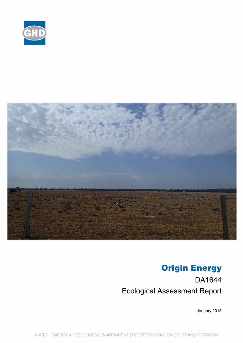
Origin Energy
DA1644 Ecological Assessment Report
January 2015

GHD | Report for Origin Energy - DA1644, 41/28330 | i
Table of contents
1. Introduction..................................................................................................................................... 1
1.1 Scope of works .................................................................................................................... 1
1.2 Definition and abbreviations ................................................................................................ 1
2. Site context..................................................................................................................................... 5
3. Methodology ................................................................................................................................... 6
3.1 Desktop and literature review .............................................................................................. 6
3.2 Field survey .......................................................................................................................... 7
4. Results and discussions ............................................................................................................... 10
4.1 Desktop and literature review ............................................................................................ 10
4.2 Field survey ........................................................................................................................ 10
5. Conclusions .................................................................................................................................. 16
Table index
Table 1 Definitions .................................................................................................................................... 1
Table 2 Abbreviations ............................................................................................................................... 2
Table 3 Revision history ........................................................................................................................... 3
Table 4 Associated document references ................................................................................................ 3
Table 5 Site context .................................................................................................................................. 5
Table 6 Desktop and literature review sources ........................................................................................ 6
Table 7 Commonwealth environmental values – field survey results .................................................... 11
Table 8 State environmental matters – field survey results ................................................................... 12
Table 9 Ground-truthed regional ecosystems and regrowth vegetation ................................................ 13
Table 10 Pest flora and fauna species recorded from field surveys ...................................................... 14
Appendices
Appendix A – Survey location
Appendix B – EPBC Protected Matters Search Tool results
Appendix C – Wildlife Online database search results
Appendix D – DEHP Certified Regional Ecosystem Mapping
Appendix E – DEHP Mapped Environmentally Sensitive Areas
Appendix F – DEHP Map of Referrable Wetlands and Wetland Protection Areas
Appendix G – DEHP Protected Plants Flora Survey Trigger Map

ii | GHD | Report for Origin Energy - DA1644, 41/28330
Appendix H – List of flora and fauna species identified in the Study Area
Appendix I – Ground-truthed Regional Ecosystems and Regrowth
Appendix J – Ground-truthed pest flora and fauna
Appendix K – Ground-truthed conservation significant species
Appendix L – Ground-truthed watercourses and waterways
GHD | Report for Origin Energy - DA1644, 41/28330 | 1
1. Introduction
This report provides a description of the ecological values within Lots 50 BWR477 and 51 BWR126 (Disturbance Approval (DA)1644), herein referred to as ‘the Site’. The results included in this report are based on an initial desktop assessment followed by a field survey to confirm the vegetation communities, flora and fauna species, habitat values and areas of disturbance.
The field surveys and reporting were undertaken by Nick Willis and Shelley Wilkins. Both ecologists were approved to undertake ecological surveys by Commonwealth Department of Environment (DoE) (formerly the Department of Sustainability, Environment, Water, Population and Communities) in writing on 15 March 2012. Field surveys were undertaken on 18 November 2014.
1.1 Scope of works
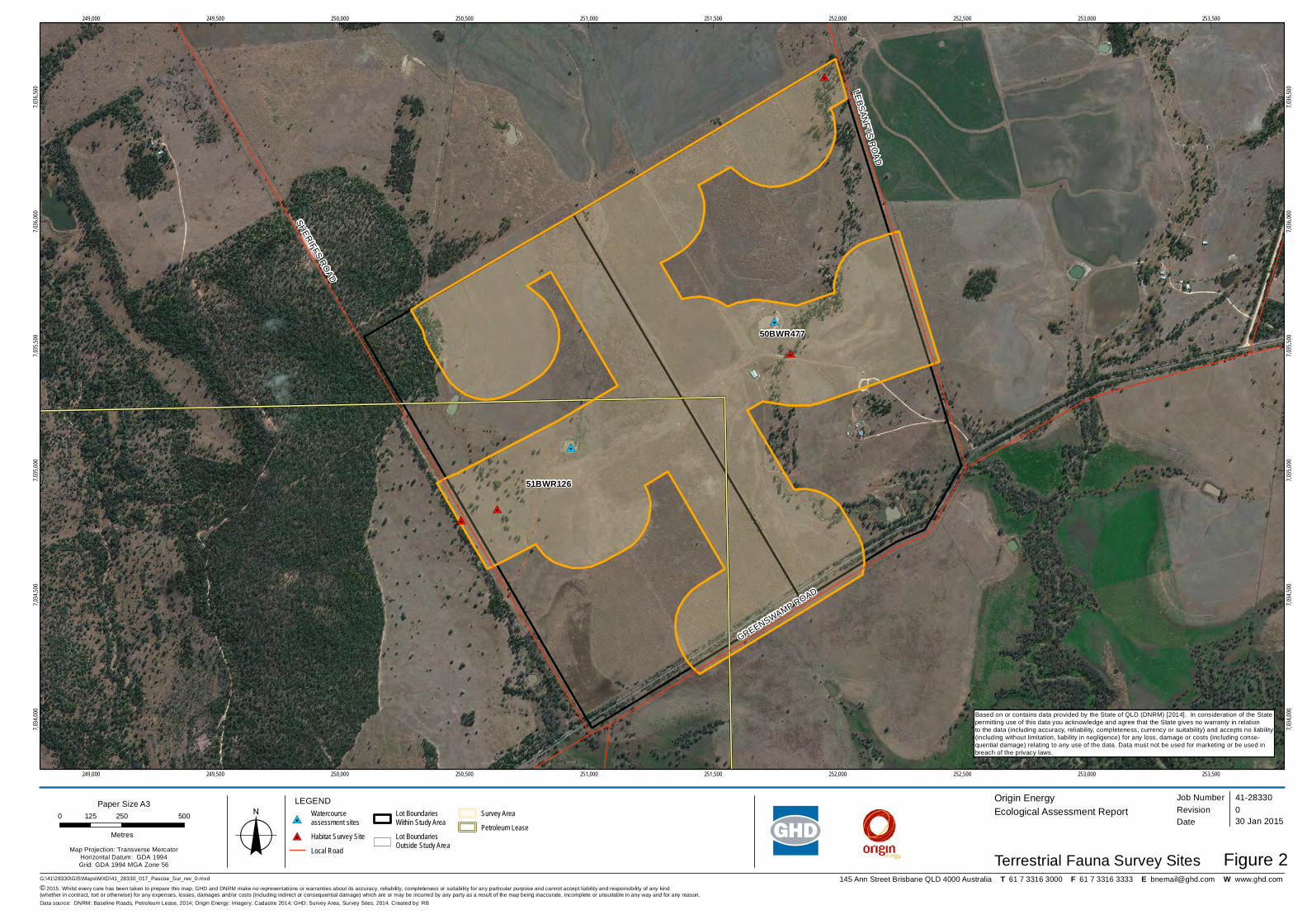
An ecological assessment was required within Lot 50 BWR477 and Lot 51 BWR126. The survey was limited to a defined buffer area surrounding the outer limit of proposed disturbance within the two properties and adjacent road reserves. The survey extent is shown in Appendix A, with these figures displaying vegetation assessment sites and fauna habitat assessment sites
1.2 Definition and abbreviations
1.2.1 Definitions
Descriptions of key terms are detailed in Table 1.
Table 1 Definitions
Term Definition
Site The full extent of land within the property boundary
Ecological Survey Buffer
The nominal buffer was 150 m from the edge of expected disturbance for linear infrastructure and 200 m from the edge of expected disturbance for non-linear infrastructure.
Study Area Area surveyed as a part of the ecological assessment incorporating the Ecological Survey Buffer within the property boundary of Lot 50 BWR477 and Lot 51 BWR126 and adjacent road reserves.
Ramsar Convention on Wetlands of International Importance (the Ramsar Convention) was signed in Ramsar, Iran on 2 February 1971. The Ramsar Convention aims to halt the worldwide loss of wetlands and to conserve, through wise use and management, those that remain. The Convention encourages member countries to nominate sites containing representative, rare or unique wetlands, or that are important for conserving biological diversity, to the List of Wetlands of International Importance (Ramsar sites).
Remnant vegetation Woody vegetation within the Ecologically Dominant Layer comprising > 70% of the height and > 50% of the cover relative to the undisturbed height and cover of that stratum and is dominated by species characteristic of the vegetation’s undisturbed canopy.
2 | GHD | Report for Origin Energy - DA1644, 41/28330
Term Definition
Trimble Trimble integrates positioning technologies such as GPS, laser and optical with application software, wireless communications and services to provide innovative positioning solutions for applications such as surveying, construction and engineering.
Solutions include GPS/GNSS, optical total stations, 3D laser scanners, machine guidance systems, construction lasers and software.
1.2.2 Abbreviations
Abbreviations used through the report are explained in Table 2.
Table 2 Abbreviations
Abbreviation Description
Australia Pacific LNG Australia Pacific LNG Pty Limited
BoM Bureau of Meteorology
Cth Commonwealth Legislation
DA Disturbance Approval
DEHP Department of Environment and Heritage Protection (Qld)
DoE Department of Environment
DNRM Department of Natural Resources and Mines (Qld)
DSITIA Department of Science, Information Technology, Innovation and the Arts (Qld)
EP Act Environmental Protection Act 1994 (Qld)
EPBC Act Environment Protection and Biodiversity Conservation Act 1999 (Cth)
ESA Environmentally Sensitive Area
GPS Global positioning system
GTRE Ground-truthed regional ecosystem
I Introduced status under the NC Act
km Kilometres
LC Least Concern status under the NC Act
LP Act Land Protection (Pest and Stock Route Management) Act 2002 (Qld)
Ma Marine status under the EPBC Act
Mi Migratory status under the EPBC Act
MNES Matters of National Environmental Significance
NC Act Nature Conservation Act 1992 (Qld)
GHD | Report for Origin Energy - DA1644, 41/28330 | 3
Abbreviation Description
NC Reg Nature Conservation (Wildlife) Regulation 2006 (Qld)
Qld Queensland
RE Regional Ecosystem
SLC Special Least Concern status under the NC Act
TEC Threatened Ecological Community
WoNS Weed of National Significance
1.2.3 Document revision table
Revisions of the document are outlined in Table 3.
Table 3 Revision history
Revision Date Description
1.2.4 Document references
Documents referenced in developing this report are identified in Table 4. Some documents were not referred to in the report, but were used nevertheless as reference text for guidance and/or desktop assessments.
Table 4 Associated document references
Document number
Title
Q-LNG01-15-MP-0109
Australian Pacific LNG (2011), Environmental Constraints Planning and Field Development Protocol
BOM (2012), Bureau of Meteorology - Climate statistics for Australian Locations. http://www.bom.gov.au/climate/data/index.shtml?bookmark=201 Accessed: 24 November 2014
DEHP (2014a), Map of Referable Wetlands, Wetland Protection Areas/Wetland Management Areas. Map Request Form - Referable Wetlands. Department of Environment and Heritage Protection, Queensland Government, Brisbane. https://www.ehp.qld.gov.au/ecosystems/wetlands/referable-wetlands-form.php Accessed: 10 November 2014.
DEHP (2014b), Environmentally Sensitive Areas – Chapter 5A activities (EP Act) Map. Regional Ecosystem Maps/ Regrowth Vegetation Maps and PMAVs. Department of Environment and Heritage Protection, Queensland Government, Brisbane. https://www.ehp.qld.gov.au/licences-permits/maps_of_environmentally_sensitive_areas.php
Accessed: 10 November 2014.

4 | GHD | Report for Origin Energy - DA1644, 41/28330
Document number
Title
DEHP (2014c) Protected Plants Flora Survey Trigger Map. Department of Environment and Heritage Protection, Brisbane. https://www.ehp.qld.gov.au/licences-permits/plants-animals/protected-plants/map-request.php. Accessed: 10 November 2014.
DEHP (2014d) Regional Ecosystem Description Database (REDD V8.0) Department of Environment and Heritage Protection, Brisbane. http://www.ehp.qld.gov.au/ecosystems/biodiversity/regional-ecosystems/index.php Accessed 10 November 2014.
DEHP (2014e), Vegetation Map Request. Department of Natural Resources and Mines, Queensland Government, Brisbane. http://www.dnrm.qld.gov.au/forms/land-property/vegetation-map-request Accessed 16 Oct 2014
DNRM (2014a) Mines Online Maps. Department of Natural Resources and Mines, Queensland Government, Brisbane. http://www.dnrm.qld.gov.au/mapping-data/maps/minesonlinemaps.
Accessed: 10 November 2014.
DoE, (2013), Significant Impact Guidelines 1.1: Matters of National Environmental Significance. Department of the Environment, Canberra. Available from: http://www.environment.gov.au/epbc/publications/nes-guidelines.html Accessed 10 November 2014
DoE (2014) Species Profile and Threats Database (EPBC Act List of Threatened Ecological Communities and Species). Department of the Environment, Canberra. http://www.environment.gov.au/cgi-bin/sprat/public/sprat.pl Accessed 10 November 2014.
DSITIA (2014), Wildlife Online. Department of Science, Information Technology, Innovation and the Arts, Queensland Government, Brisbane. https://environment.ehp.qld.gov.au/report-request/species-list/ Accessed 10 November 2014.
Eyre TJ, Ferguson DJ, Hourigan CL, Smith GC, Mathieson MT, Kelly, AL, Venz MF and Hogan, LD. (2012). Terrestrial Vertebrate Fauna Survey Assessment Guidelines for Queensland. Department of Science, Information Technology, Innovation and the Arts, Queensland Government, Brisbane.
Neldner, V.J., Wilson, B. A., Thompson, E.J. and Dillewaard, H.A. (2012). Methodology for Survey and Mapping of Regional Ecosystems and Vegetation Communities in Queensland. Version 3.2. Updated August 2012. Queensland Herbarium, Queensland Department of Science, Information Technology, Innovation and the Arts, Brisbane. 124 pp.
GHD | Report for Origin Energy - DA1644, 41/28330 | 5
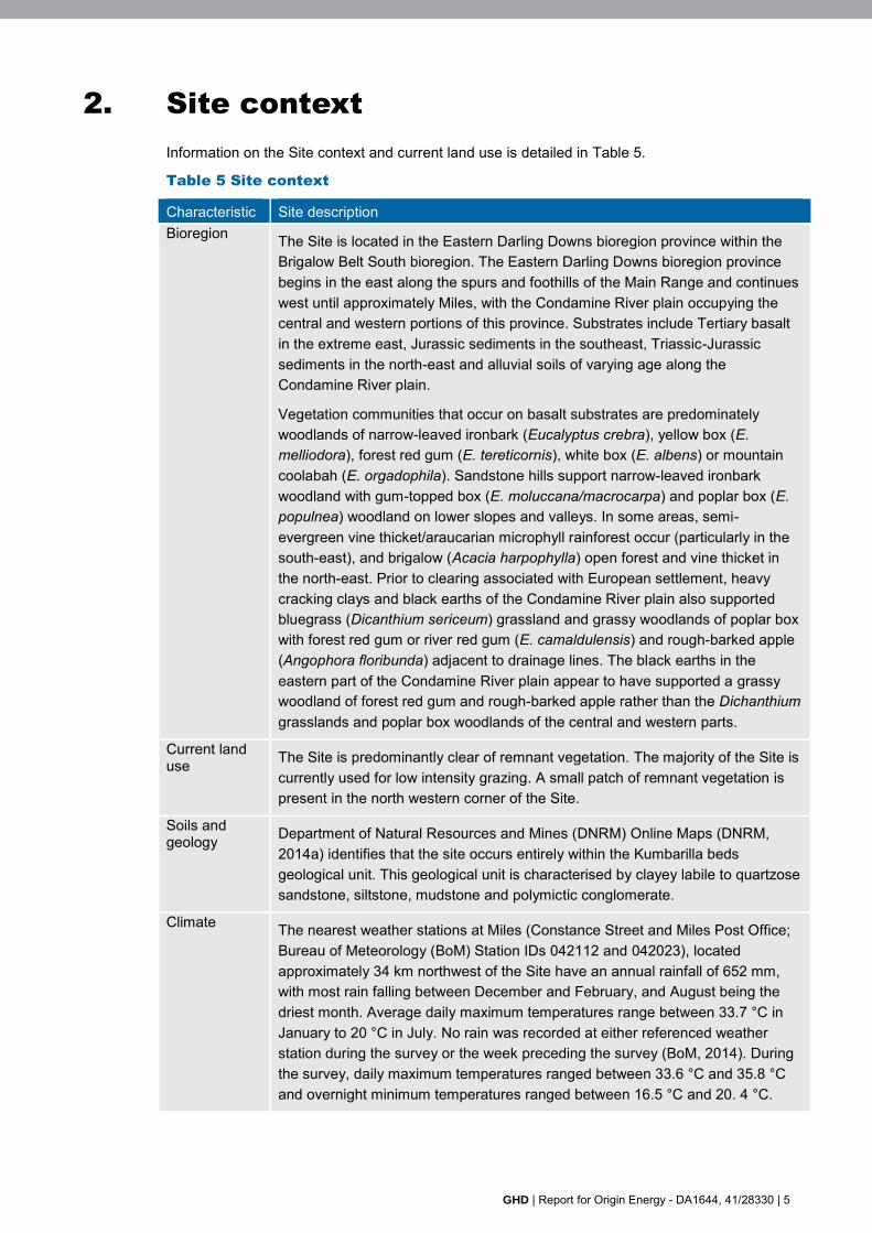
2. Site context
Information on the Site context and current land use is detailed in Table 5.
Table 5 Site context
Characteristic Site description Bioregion The Site is located in the Eastern Darling Downs bioregion province within the
Brigalow Belt South bioregion. The Eastern Darling Downs bioregion province begins in the east along the spurs and foothills of the Main Range and continues west until approximately Miles, with the Condamine River plain occupying the central and western portions of this province. Substrates include Tertiary basalt in the extreme east, Jurassic sediments in the southeast, Triassic-Jurassic sediments in the north-east and alluvial soils of varying age along the Condamine River plain.
Vegetation communities that occur on basalt substrates are predominately woodlands of narrow-leaved ironbark (Eucalyptus crebra), yellow box (E. melliodora), forest red gum (E. tereticornis), white box (E. albens) or mountain coolabah (E. orgadophila). Sandstone hills support narrow-leaved ironbark woodland with gum-topped box (E. moluccana/macrocarpa) and poplar box (E. populnea) woodland on lower slopes and valleys. In some areas, semi-evergreen vine thicket/araucarian microphyll rainforest occur (particularly in the south-east), and brigalow (Acacia harpophylla) open forest and vine thicket in the north-east. Prior to clearing associated with European settlement, heavy cracking clays and black earths of the Condamine River plain also supported bluegrass (Dicanthium sericeum) grassland and grassy woodlands of poplar box with forest red gum or river red gum (E. camaldulensis) and rough-barked apple (Angophora floribunda) adjacent to drainage lines. The black earths in the eastern part of the Condamine River plain appear to have supported a grassy woodland of forest red gum and rough-barked apple rather than the Dichanthium grasslands and poplar box woodlands of the central and western parts.
Current land use The Site is predominantly clear of remnant vegetation. The majority of the Site is
currently used for low intensity grazing. A small patch of remnant vegetation is present in the north western corner of the Site.
Soils and geology Department of Natural Resources and Mines (DNRM) Online Maps (DNRM,
2014a) identifies that the site occurs entirely within the Kumbarilla beds geological unit. This geological unit is characterised by clayey labile to quartzose sandstone, siltstone, mudstone and polymictic conglomerate.
Climate The nearest weather stations at Miles (Constance Street and Miles Post Office; Bureau of Meteorology (BoM) Station IDs 042112 and 042023), located approximately 34 km northwest of the Site have an annual rainfall of 652 mm, with most rain falling between December and February, and August being the driest month. Average daily maximum temperatures range between 33.7 °C in January to 20 °C in July. No rain was recorded at either referenced weather station during the survey or the week preceding the survey (BoM, 2014). During the survey, daily maximum temperatures ranged between 33.6 °C and 35.8 °C and overnight minimum temperatures ranged between 16.5 °C and 20. 4 °C.
6 | GHD | Report for Origin Energy - DA1644, 41/28330
3. Methodology
The methodology used to compile this Ecological Assessment Report consisted of:
A desktop and literature review of ecological databases and literature sources as direct references for the survey undertaken; and
A field survey of the Study Area to ground-truth environmental attributes and current Site conditions within the Study Area.
An explanation of these activities is outlined in this section.
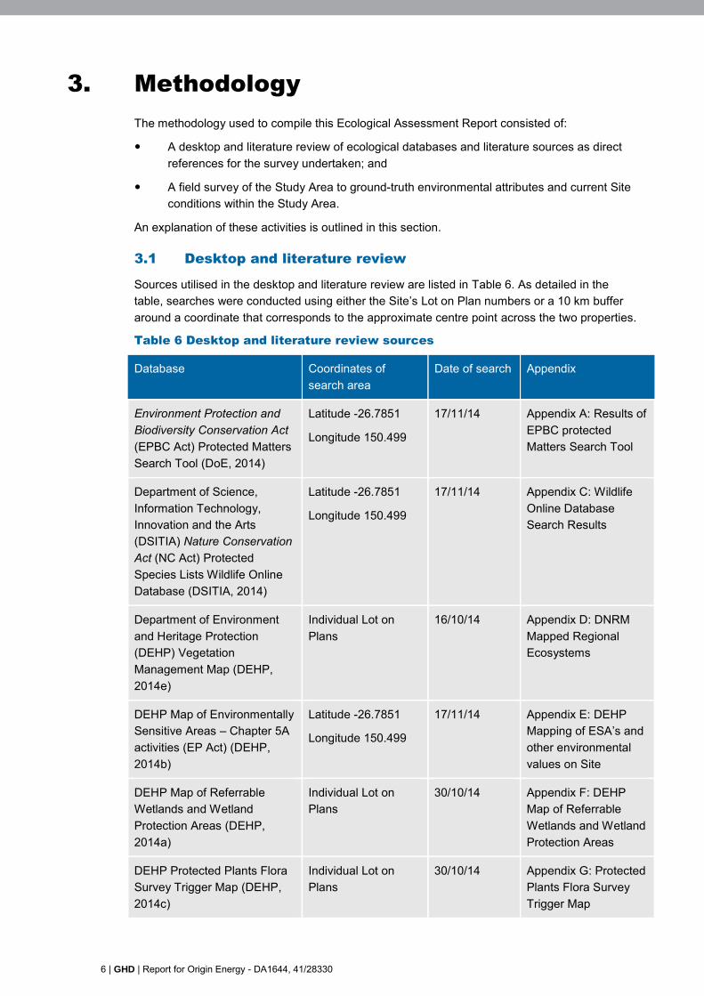
3.1 Desktop and literature review
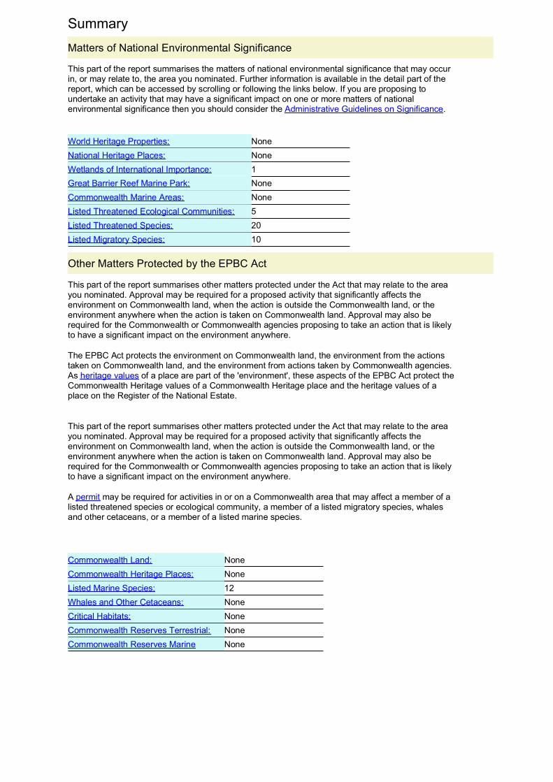
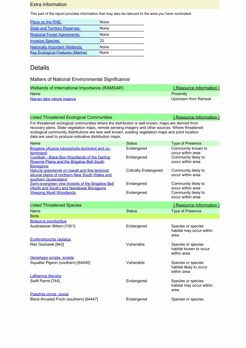
Sources utilised in the desktop and literature review are listed in Table 6. As detailed in the table, searches were conducted using either the Site’s Lot on Plan numbers or a 10 km buffer around a coordinate that corresponds to the approximate centre point across the two properties.
Table 6 Desktop and literature review sources
Database Coordinates of search area
Date of search Appendix
Environment Protection and Biodiversity Conservation Act (EPBC Act) Protected Matters Search Tool (DoE, 2014)
Latitude -26.7851
Longitude 150.499
17/11/14 Appendix A: Results of EPBC protected Matters Search Tool
Department of Science, Information Technology, Innovation and the Arts (DSITIA) Nature Conservation Act (NC Act) Protected Species Lists Wildlife Online Database (DSITIA, 2014)
Latitude -26.7851
Longitude 150.499
17/11/14 Appendix C: Wildlife Online Database Search Results
Department of Environment and Heritage Protection (DEHP) Vegetation Management Map (DEHP, 2014e)
Individual Lot on Plans
16/10/14 Appendix D: DNRM Mapped Regional Ecosystems
DEHP Map of Environmentally Sensitive Areas – Chapter 5A activities (EP Act) (DEHP, 2014b)
Latitude -26.7851
Longitude 150.499
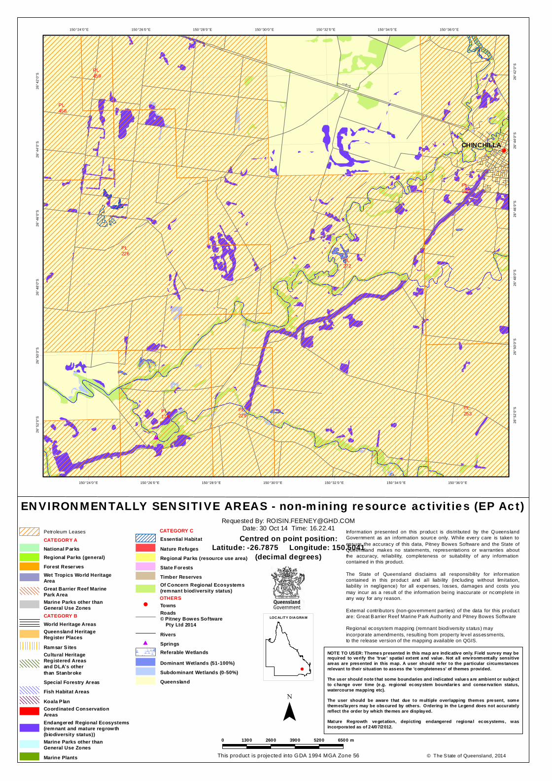
17/11/14 Appendix E: DEHP Mapping of ESA’s and other environmental values on Site
DEHP Map of Referrable Wetlands and Wetland Protection Areas (DEHP, 2014a)
Individual Lot on Plans
30/10/14 Appendix F: DEHP Map of Referrable Wetlands and Wetland Protection Areas
DEHP Protected Plants Flora Survey Trigger Map (DEHP, 2014c)
Individual Lot on Plans
30/10/14 Appendix G: Protected Plants Flora Survey Trigger Map
GHD | Report for Origin Energy - DA1644, 41/28330 | 7
3.2 Field survey
Ecological surveys were conducted in accordance with:
The Methodology for Survey and Mapping of Regional Ecosystems and Vegetation Communities in Queensland (Neldner et al., 2012); and
The methodology described in the Environmental Constraints Planning and Field Development Protocol (Q-LNG01-15-MP-0109, Australia Pacific LNG 2011).
Field surveys were undertaken on 18 November 2014.
3.2.1 Vegetation community survey
As there was only one small patch of remnant vegetation contained within the Study Area, one baseline vegetation community survey was undertaken to describe dominant flora and vegetation community structure within this patch. The vegetation community survey was consistent with the data collection protocols described in Neldner et al. (2012).
The vegetation community survey was undertaken within a 50 m x 10 m plot for the purpose of typifying the vegetation community under assessment. Given that the site was largely devoid of vegetation, only one formal vegetation community survey site was assessed within the Study Area (Appendix A). This survey site has been recorded as a ‘Vegetation Structure Point’ within the accompanying spatial data.
Ground-truthing of DEHP Regional Ecosystem (RE) designations (DEHP, 2014e) was undertaken via Quaternary level assessment as described by Neldner et al. (2012). The site for Quaternary assessment was chosen based on DEHP regulated vegetation management mapping version 8.0.
Vegetation community data was entered into the data fields provided by the Trimble data capture system.
The mapped vegetation community polygon was confirmed, mapped and identified in accordance with Queensland RE (biodiversity status) and EPBC Act threatened ecological community (TEC) criteria. The collection of all data was in accordance with Q-LNG01-15-MP-0109 Australia Pacific LNG (2011) Environmental Constraints Planning and Field Development Protocol.
3.2.2 Habitat surveys
A total of four formal habitat surveys were undertaken across the Study Area, as presented inAppendix A. These survey sites have been recorded as ‘Habitat Site Points’ within the accompanying spatial data.
Within each habitat survey, a range of habitat features were recorded on the relevant Trimble data form, including:
Rocks and boulders (estimated per cent cover);
Rocky outcrops;
Logs (abundance);
Trees with hollows (abundance);
Presence of senescent (old) or dead trees (stags);
Trees and/or logs with loose bark (abundance);
Shrub layer (estimated per cent cover);
Ground cover (estimated per cent cover);
8 | GHD | Report for Origin Energy - DA1644, 41/28330
Leaf litter (per cent cover);
Termite mounds (abundance);
Mistletoe (abundance);
Caves/ledges (abundance); and
Any additional fauna habitat features.
The collection of this data was in accordance with Q-LNG01-15-MP-0109 Australia Pacific LNG (2011) Environmental Constraints Planning and Field Development Protocol.
3.2.3 Threatened flora and fauna survey
Threatened species are those listed under the EPBC Act 1999 and the Nature Conservation (Wildlife) Regulation 2006 (NC Reg).
Targeted flora and fauna searches were undertaken for threatened species identified as potentially occurring within the Site by the database and literature review. Search effort targeted areas of potentially suitable habitat for particular threatened species. Opportunistic searches were also undertaken to locate threatened flora and fauna species during the course of other surveys.
If found to be present, any observations of threatened flora or fauna species were recorded using the Trimble data capture system. If present, any flora specimens deemed as potential threatened species were sent to the Queensland Herbarium for verification.
3.2.4 Exotic flora and fauna survey
Declared flora and fauna defined by the Land Protection (Pest and Stock Route Management) Act 2002 (LP Act) encountered opportunistically during field surveys were entered into the Trimble unit. Exact locations of undeclared pest plants were not entered into the Trimble system. However the general abundance of pest species was recorded across the Study Area, with results presented in Section 4.2.2 of this report.
3.2.5 Disturbance survey
Evidence of existing disturbances within the Study Area was opportunistically recorded during the field survey. For each disturbance, the location, type, severity and estimated age of the disturbance was noted.
3.2.6 Watercourse assessments
Watercourse assessments were undertaken along the length of all mapped stream orders within the Site. The thalweg of each mapped waterway was traversed by the field team to determine if these mapped features satisfy the watercourse definition requirements of the Water Act 2000, or are considered to be drainage features in accordance with the Water Act 2000. Where the definition of a watercourse under the Water Act 2000 was satisfied, GPS points of the high banks were also marked periodically along the watercourse to support the mapping of the watercourse.Watercourse assessment sites are shown in Appendix A.
Under the Water Act 2000 a watercourse is defined as:
A river, creek or other stream, including a stream in the form of an anabranch or a tributary, in which water flows permanently or intermittently, regardless of the frequency of flow events—
(a) in a natural channel, whether artificially modified or not; or
(b) in an artificial channel that has changed the course of the stream.
GHD | Report for Origin Energy - DA1644, 41/28330 | 9
A watercourse also includes in-stream islands, benches and bars, but does not include drainage features.
Drainage features are defined under the Water Act 2000 as:
Natural landscape features, including a gully, drain, drainage depression or other erosion feature that—
(a) is formed by the concentration of, or operates to confine or concentrate, overland flow water during and immediately after rainfall events; and
(b) flows for only a short duration after a rainfall event, regardless of the frequency of flow events; and
(c) commonly, does not have enough continuing flow to create a riverine environment.
Where present, wetlands were assessed for the ecological character to confirm the integrity of the wetland. The definition of a wetland included in the Wetland Mapping and Classification Methodology (EPA, 2005) has been used in this assessment, which states:
Areas of permanent or periodic/intermittent inundation, with water that is static or flowing fresh, brackish or salt, including areas of marine water the depth of which at low tide does not exceed 6 m. To be a wetland the area must have one or more of the following attributes:
at least periodically the land supports plants or animals that are adapted to and dependent on living in wet conditions for at least part of their life cycle; or
the substratum is predominantly undrained soils that are saturated, flooded or ponded long enough to develop anaerobic conditions in the upper layers; or
the substratum is not soil and is saturated with water, or covered by water at some time.
3.2.7 Survey limitations
A number of factors are likely to influence the survey results for particular species or species groups. These factors comprise:
Timing (seasons) and duration of the survey period;
Weather conditions in the preceding seasons, and immediately prior to the survey; and
Restricted spatial area of the habitats within the Study Area.
The surveys represent a single, rapid assessment of local flora and fauna communities in one point in time. Fauna and to a lesser extent flora community composition vary through time in response to daily, seasonal and annual changes in environmental conditions and species movements and migrations. Some grasses and cryptic flora species can only be detected or positively identified during particular flowering periods, such as after extensive summer rainfall, or Spring time flowering periods for some species.
The field surveys were restricted to diurnal passive survey techniques (i.e. no live trapping). This is likely to have reduced the abundance and diversity of amphibians and cryptic reptile species encountered and some species may therefore be underrepresented in the data reported.
10 | GHD | Report for Origin Energy - DA1644, 41/28330
4. Results and discussions
This section includes the results of the desktop and field survey. Further information is contained in the Appendices and is referenced below.
4.1 Desktop and literature review
Results of the desktop and literature review can be found in Appendix A to Appendix G, as listed in Table 6.
4.2 Field survey
The results of field surveys are detailed in the following sections. A comprehensive list of flora and fauna species identified during the field survey is included in Appendix H.
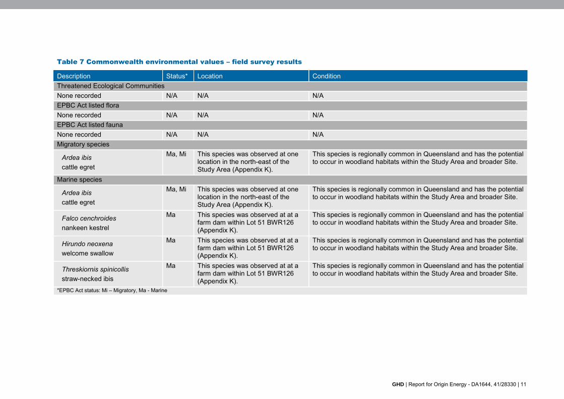
4.2.1 Commonwealth environmental matters
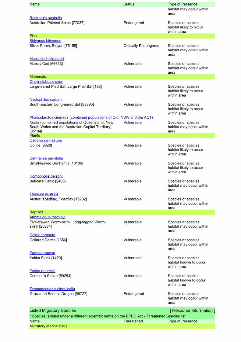
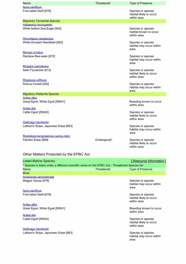
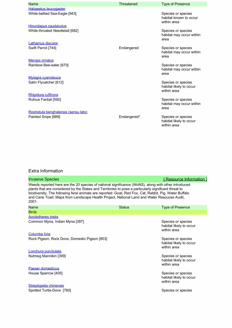
Field survey results for Commonwealth environmental matters (Matters of National Environmental Significance (MNES), TECs, threatened species) are outlined in Table 7. The locations of EPBC Act threat-listed species are provided in Appendix K.
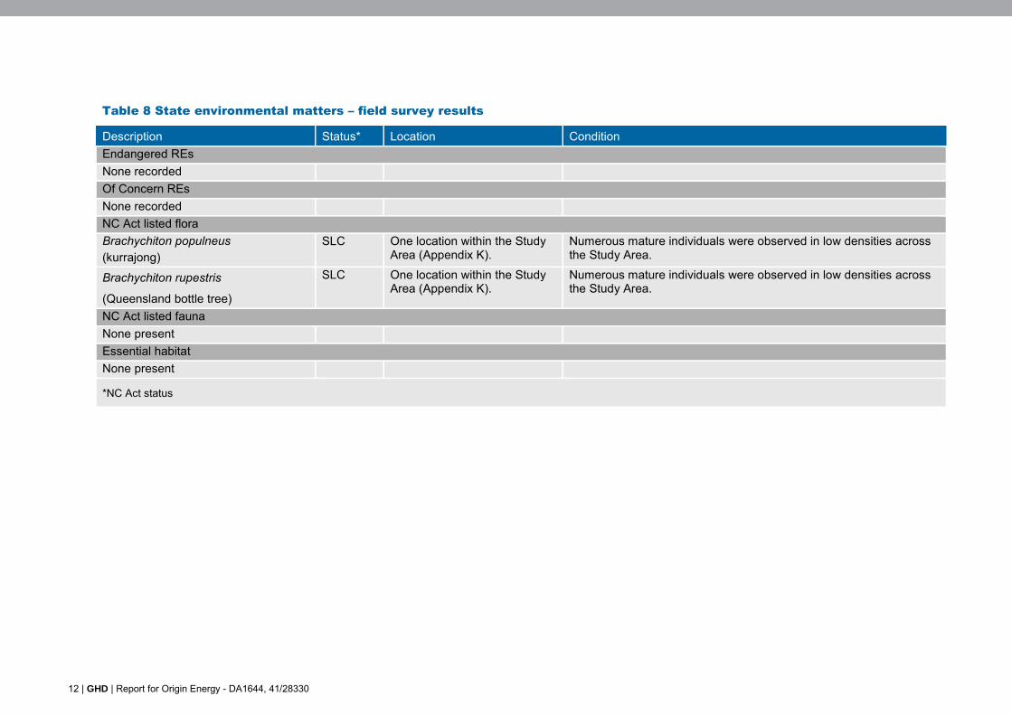
4.2.2 Queensland environmental matters
Field survey results
Field survey results for Matters of State Environmental Significance (MSES), including REs as defined under the (EP Act and species listed as conservation significant under the NC Act, are outlined in Table 8. The locations of NC Act threat-listed species are provided in Appendix K.
Ground-truthed regional ecosystems and regrowth vegetation
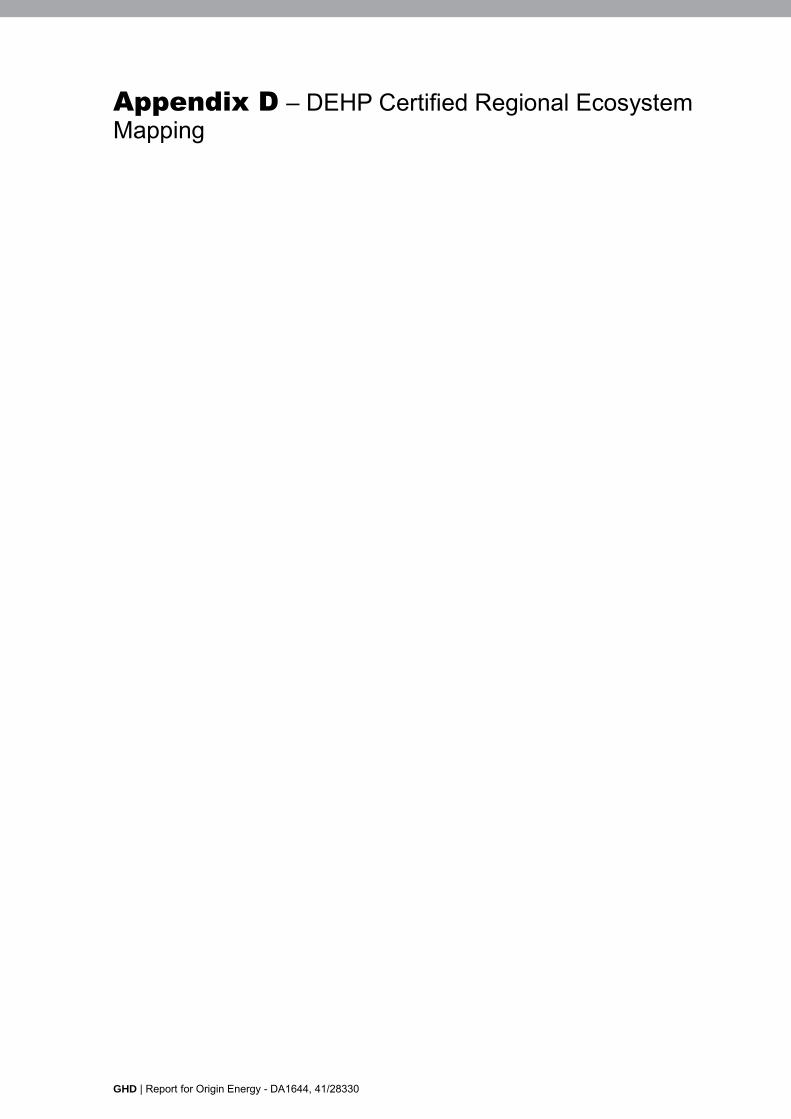
DEHP mapping (DEHP, 2014e) identified an area that is a least concern RE within the north western corner of the Study Area (Appendix D). The polygon of remnant vegetation was represented as a heterogeneous polygon on the mapped regulated vegetation for the Study Area, consisting of three vegetation communities. This was ground-truthed as partially correct and results are presented in Table 9. Ground-truthed REs (GTRE) are mapped in Appendix I.
GHD | Report for Origin Energy - DA1644, 41/28330 | 11
Table 7 Commonwealth environmental values – field survey results
Description Status* Location Condition Threatened Ecological Communities None recorded N/A N/A N/A EPBC Act listed flora None recorded N/A N/A N/A EPBC Act listed fauna None recorded N/A N/A N/A Migratory species
Ardea ibis cattle egret
Ma, Mi This species was observed at one location in the north-east of the Study Area (Appendix K).
This species is regionally common in Queensland and has the potential to occur in woodland habitats within the Study Area and broader Site.
Marine species
Ardea ibis cattle egret
Ma, Mi This species was observed at one location in the north-east of the Study Area (Appendix K).
This species is regionally common in Queensland and has the potential to occur in woodland habitats within the Study Area and broader Site.
Falco cenchroides nankeen kestrel
Ma This species was observed at at a farm dam within Lot 51 BWR126 (Appendix K).
This species is regionally common in Queensland and has the potential to occur in woodland habitats within the Study Area and broader Site.
Hirundo neoxena welcome swallow
Ma This species was observed at at a farm dam within Lot 51 BWR126 (Appendix K).
This species is regionally common in Queensland and has the potential to occur in woodland habitats within the Study Area and broader Site.
Threskiornis spinicollis straw-necked ibis
Ma This species was observed at at a farm dam within Lot 51 BWR126 (Appendix K).
This species is regionally common in Queensland and has the potential to occur in woodland habitats within the Study Area and broader Site.
*EPBC Act status: Mi – Migratory, Ma - Marine
12 | GHD | Report for Origin Energy - DA1644, 41/28330
Table 8 State environmental matters – field survey results
Description Status* Location Condition Endangered REs None recorded Of Concern REs None recorded NC Act listed flora Brachychiton populneus (kurrajong)
SLC One location within the Study Area (Appendix K).
Numerous mature individuals were observed in low densities across the Study Area.
Brachychiton rupestris
(Queensland bottle tree)
SLC One location within the Study Area (Appendix K).
Numerous mature individuals were observed in low densities across the Study Area.
NC Act listed fauna None present Essential habitat None present
*NC Act status

GHD | Report for Origin Energy - DA1644, 41/28330 | 13
Table 9 Ground-truthed regional ecosystems and regrowth vegetation
State mapped RE*
Biodiversity status
Short description^ Ground-truthed RE
Biodiversity status
Short description^ Ground-truthed description
11.5.1/11.7.5/ 11.7.2 remnant (90/5/5)
No concern at present
11.5.1: Eucalyptus crebra and/or E. populnea, Callitris glaucophylla, Angophora leiocarpa, Allocasuarina luehmannii woodland on Cainozoic sand plains/remnant surfaces 11.7.5: Shrubland on natural scalds on deeply weathered coarse-grained sedimentary rocks 11.7.2: Acacia spp. woodland on Cainozoic lateritic duricrust. Scarp retreat zone
11.5.1 remnant (100)
No concern at present
11.5.1: Eucalyptus crebra and/or E. populnea, Callitris glaucophylla, Angophora leiocarpa, Allocasuarina luehmannii woodland on Cainozoic sand plains/remnant surfaces
Woodland to open woodland community on undulating plains. Canopy co-dominated by Eucalyptus crebra and E. populnea, with a lower sparse tree layer of Callitris glaucophylla, Allocasuarina leuhmannii and Ventilago viminalis (10-12 m). A shrub layer is present dominated by Acacia excela, Acacia harpophylla, Alstonia constricta and capparis lasiantha. Ground cover consisted of mid dense to sparse grass species, however, identification was not possible due to timing of survey (end of dry season). Opuntia tomentosa was recorded in low numbers within the community. The boundary of this polygon was extended by ground-truthing.
*Source: DEHP 2014e; ^ Source: DEHP 2014d
14 | GHD | Report for Origin Energy - DA1644, 41/28330
Other environmental values
In general, the Study Area is largely clear of remnant vegetation and is actively used for moderate intensity grazing. Historically the Site has been used for irrigated cultivation. Due to the current and historical land use of the Site which involved vegetation clearing and annual crop cultivation the ecological values are limited. However, sparse vegetation was noted within the Study Area which may provide refuge habitat for traversing fauna species.
A small polygon of no concern at present remnant RE 11.5.1 was ground-truthed as present in the north western corner of the Study Area. This vegetation community is likely to provide habitat for a range of fauna species including birds, mammals and reptiles.
In addition, a first order stream and second order stream were ground-truthed as intersecting the Study Area. Selectively cleared regrowth riparian vegetation was noted surrounding the second order stream which is likely to provide habitat for amphibians and birds and may potentially act as a movement corridor for ground mammals. No riparian vegetation was noted surrounding the first order stream, limiting the habitat value to amphibians and potentially reptiles.
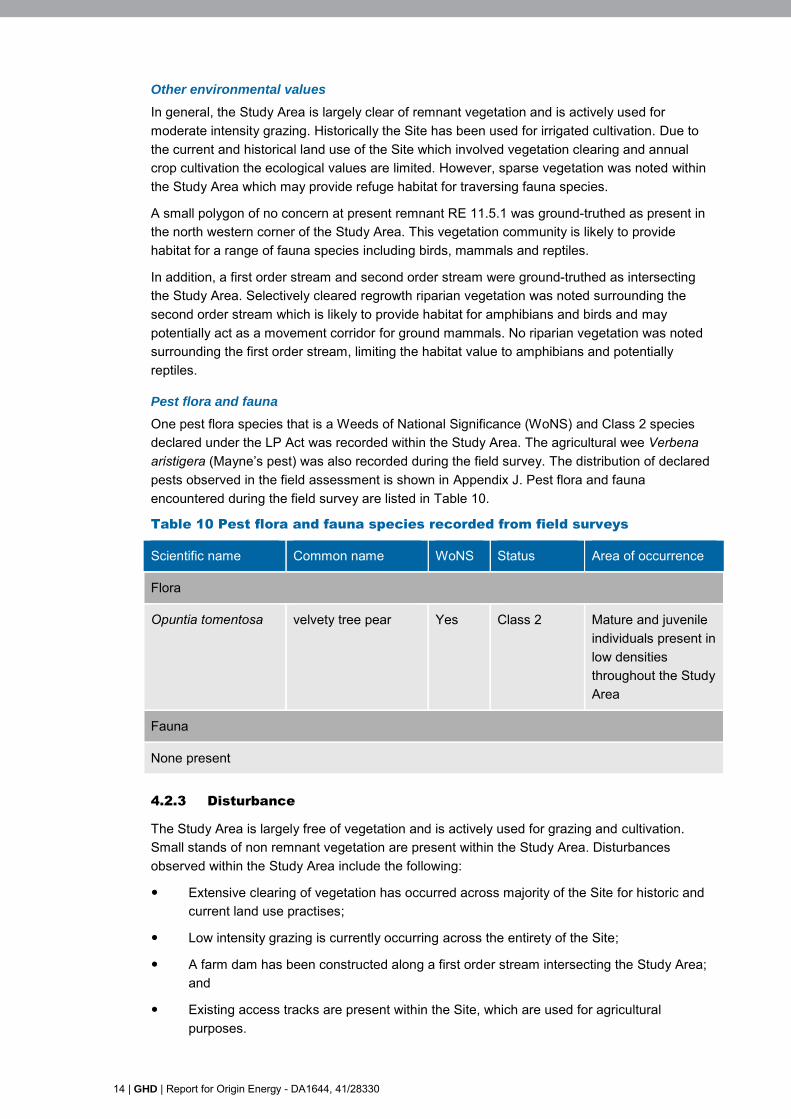
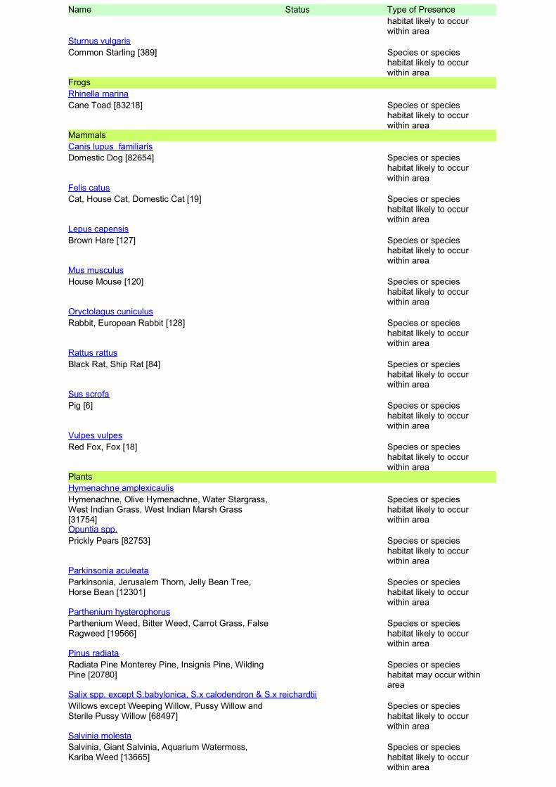
Pest flora and fauna
One pest flora species that is a Weeds of National Significance (WoNS) and Class 2 species declared under the LP Act was recorded within the Study Area. The agricultural wee Verbena aristigera (Mayne’s pest) was also recorded during the field survey. The distribution of declared pests observed in the field assessment is shown in Appendix J. Pest flora and fauna encountered during the field survey are listed in Table 10.
Table 10 Pest flora and fauna species recorded from field surveys
Scientific name Common name WoNS Status Area of occurrence
Flora
Opuntia tomentosa velvety tree pear Yes Class 2 Mature and juvenile individuals present in low densities throughout the Study Area
Fauna
None present
4.2.3 Disturbance
The Study Area is largely free of vegetation and is actively used for grazing and cultivation. Small stands of non remnant vegetation are present within the Study Area. Disturbances observed within the Study Area include the following:
Extensive clearing of vegetation has occurred across majority of the Site for historic and current land use practises;
Low intensity grazing is currently occurring across the entirety of the Site;
A farm dam has been constructed along a first order stream intersecting the Study Area; and
Existing access tracks are present within the Site, which are used for agricultural purposes.

GHD | Report for Origin Energy - DA1644, 41/28330 | 15
4.2.4 Watercourses
One first order stream and one second order stream were mapped as traversing the Study Area. These mapped stream orders were traversed by the field team using the methodology described in Section 3.2.6. Results of the field survey found that the first order stream did not meet the watercourse definition under the Water Act 2000. This drainage feature met the definition provided in Section 3.2.6, due to the lack of defined bed or banks, absence of riparian vegetation and was considered unlikely to support more than short term flows of water immediately following rainfall. This waterway was found to represent a temporary drainage feature across the landscape.
The second order stream intersecting the Study Area was assessed as meeting the definition of a watercourse under the Water Act 2000. Although no flow was observed at the time of field survey, the watercourse exhibited natural features in the form of defined bed and banks, a presence of riparian vegetation and forms a tributary to a third order stream, therefore meeting the definition under the Act.
Refer to Appendix L for a representation of ground-truthed water features across the Study Area.
16 | GHD | Report for Origin Energy - DA1644, 41/28330
5. Conclusions
A ‘buffer areas only’ ecological assessment was undertaken across the Study Area on 17 November 2014. Ecological features present within the Study Area include:
No TECs or threatened species listed under the EPBC Act were found on Study Area;
One Migratory species listed under the EPBC Act (Ardea ibis) and four Marine bird species listed under the EPBC Act (Ardea ibis, Falco cenchroides, Hirundo neoxena and Threskiornis spinicollis) were observed at numerous locations across the Study Area;
Two Special Least Concern flora species listed under the NC Reg were observed within the Study Area in relatively low densities, namely Brachychiton populneus and Brachychiton rupestris;
No Special Least Cconcern fauna species listed under the NC Reg were recorded;
One no concern at present RE (11.5.1) was ground-truthed during the field surveys. This vegetation community was the only RE observed within the bounds of the property and within the Study Area;
No DEHP wetland management areas or wetland protection areas are mapped as occurring within the Study Area. One first order watercourse and one second order watercourse are mapped within the Study Area;
One Class 2 declared weed species listed under the LP Act, Opuntia tomentosa was recorded at numerous location within the Study Area, which is also listed as a WoNS; and
No declared pest fauna species listed under the LP Act were recorded during the field survey.
The Study Area provides low ecological value for threatened flora and fauna species due to current and historic land use. However, it is likely that least concern fauna species may occur within sparse vegetation present across the Site. The findings of this report should be considered during detailed development planning such that disturbance to the ecological values of the Study Area and locality may be avoided wherever practical.

GHD | Report for Origin Energy - DA1644, 41/28330 | 17
This report: has been prepared by GHD for Origin Energy and may only be used and relied on by Origin Energy for the purpose agreed between GHD and the Origin Energy as set out in section 1.1 of this report.
GHD otherwise disclaims responsibility to any person other than Origin Energy arising in connection with this report. GHD also excludes implied warranties and conditions, to the extent legally permissible.
The services undertaken by GHD in connection with preparing this report were limited to those specifically detailed in the report and are subject to the scope limitations set out in the report.
The opinions, conclusions and any recommendations in this report are based on conditions encountered and information reviewed at the date of preparation of the report. GHD has no responsibility or obligation to update this report to account for events or changes occurring subsequent to the date that the report was prepared.
The opinions, conclusions and any recommendations in this report are based on assumptions made by GHD described in this report. GHD disclaims liability arising from any of the assumptions being incorrect.
GHD has prepared this report on the basis of information provided by Origin Energy and others who provided information to GHD (including Government authorities)], which GHD has not independently verified or checked beyond the agreed scope of work. GHD does not accept liability in connection with such unverified information, including errors and omissions in the report which were caused by errors or omissions in that information.

GHD | Report for Origin Energy - DA1644, 41/28330
Appendices

GHD | Report for Origin Energy - DA1644, 41/28330 | 19
Appendix A – Survey location

145 Ann Street Brisbane QLD 4000 Australia T 61 7 3316 3000 F 61 7 3316 3333 E [email protected] W www.ghd.com
SHERIFFS ROAD
GREENSWAMP ROAD
LEBSANFTS ROAD
50BWR477
51BWR126
249,000
249,000
249,500
249,500
250,000
250,000
250,500
250,500
251,000
251,000
251,500
251,500
252,000
252,000
252,500
252,500
253,000
253,000
253,500
253,500
7,034,
000
7,034,
000
7,034,
500
7,034,
500
7,035,
000
7,035,
000
7,035,
500
7,035,
500
7,036,
000
7,036,
000
7,036,
500
7,036,
500
G:\41\28330\GIS\Maps\MXD\41_28330_016_Pascoe_Sur_rev_0.mxd© 2015. Whilst every care has been taken to prepare this map, GHD and DNRM make no representations or warranties about its accuracy, reliability, completeness or suitability for any particular purpose and cannot accept liability and responsibility of any kind (whether in contract, tort or otherwise) for any expenses, losses, damages and/or costs (including indirect or consequential damage) which are or may be incurred by any party as a result of the map being inaccurate, incomplete or unsuitable in any way and for any reason.
LEGEND0 250 500125
MetresMap Projection: Transverse Mercator
Horizontal Datum: GDA 1994Grid: GDA 1994 MGA Zone 56
Origin EnergyEcological Assessment Report
Figure 1
Job NumberRevision 0
41-28330
30 Jan 2015
Terrestrial Flora Survey Siteso Date
Data source: DNRM: Baseline Roads, Petroleum Lease, 2014; Origin Energy: Imagery, Cadastre 2014; GHD: Survey Area, Survey Sites, 2014. Created by: RB
Paper Size A3Vegetation Survey SiteLocal RoadPetroleum Lease
Lot Boundaries Within Study AreaLot Boundaries Outside Study Area
Survey Area
Based on or contains data provided by the State of QLD (DNRM) [2014]. In consideration of the Statepermitting use of this data you acknowledge and agree that the State gives no warranty in relationto the data (including accuracy, reliability, completeness, currency or suitability) and accepts no liability(including without limitation, liability in negligence) for any loss, damage or costs (including conse-quential damage) relating to any use of the data. Data must not be used for marketing or be used inbreach of the privacy laws.
145 Ann Street Brisbane QLD 4000 Australia T 61 7 3316 3000 F 61 7 3316 3333 E [email protected] W www.ghd.com
#0
#0
#0
#0
#0
#0
#0
#0
SHERIFFS ROAD
GREENSWAMP ROAD
LEBSANFTS ROAD
50BWR477
51BWR126
249,000
249,000
249,500
249,500
250,000
250,000
250,500
250,500
251,000
251,000
251,500
251,500
252,000
252,000
252,500
252,500
253,000
253,000
253,500
253,500
7,034,
000
7,034,
000
7,034,
500
7,034,
500
7,035,
000
7,035,
000
7,035,
500
7,035,
500
7,036,
000
7,036,
000
7,036,
500
7,036,
500
G:\41\28330\GIS\Maps\MXD\41_28330_017_Pascoe_Sur_rev_0.mxd© 2015. Whilst every care has been taken to prepare this map, GHD and DNRM make no representations or warranties about its accuracy, reliability, completeness or suitability for any particular purpose and cannot accept liability and responsibility of any kind (whether in contract, tort or otherwise) for any expenses, losses, damages and/or costs (including indirect or consequential damage) which are or may be incurred by any party as a result of the map being inaccurate, incomplete or unsuitable in any way and for any reason.
LEGEND0 250 500125
MetresMap Projection: Transverse Mercator
Horizontal Datum: GDA 1994Grid: GDA 1994 MGA Zone 56
Origin EnergyEcological Assessment Report
Figure 2
Job NumberRevision 0
41-28330
30 Jan 2015
Terrestrial Fauna Survey Siteso Date
Data source: DNRM: Baseline Roads, Petroleum Lease, 2014; Origin Energy: Imagery, Cadastre 2014; GHD: Survey Area, Survey Sites, 2014. Created by: RB
Paper Size A3#0
Watercourseassessment sites
#0 Habitat Survey SiteLocal Road
Lot Boundaries Within Study AreaLot Boundaries Outside Study Area
Survey AreaPetroleum Lease
Based on or contains data provided by the State of QLD (DNRM) [2014]. In consideration of the Statepermitting use of this data you acknowledge and agree that the State gives no warranty in relationto the data (including accuracy, reliability, completeness, currency or suitability) and accepts no liability(including without limitation, liability in negligence) for any loss, damage or costs (including conse-quential damage) relating to any use of the data. Data must not be used for marketing or be used inbreach of the privacy laws.

20 | GHD | Report for Origin Energy - DA1644, 41/28330
Appendix B – EPBC Protected Matters Search Tool results


GHD | Report for Origin Energy - DA1644, 41/28330
Appendix C – Wildlife Online database search results

Wildlife Online Extract
Search Criteria: Species List for a Specified Point
Species: All
Type: All
Status: All
Records: All
Date: All
Latitude: -26.7851
Longitude: 150.499
Distance: 10
Email: [email protected]
Date submitted: Monday 17 Nov 2014 14:27:20
Date extracted: Monday 17 Nov 2014 14:30:24
The number of records retrieved = 352
Disclaimer
As the DSITIA is still in a process of collating and vetting data, it is possible the information given is not complete. The information provided should only be usedfor the project for which it was requested and it should be appropriately acknowledged as being derived from Wildlife Online when it is used.
The State of Queensland does not invite reliance upon, nor accept responsibility for this information. Persons should satisfy themselves through independentmeans as to the accuracy and completeness of this information.
No statements, representations or warranties are made about the accuracy or completeness of this information. The State of Queensland disclaims allresponsibility for this information and all liability (including without limitation, liability in negligence) for all expenses, losses, damagesand costs you may incur as a result of the information being inaccurate or incomplete in any way for any reason.
Feedback about Wildlife Online should be emailed to [email protected]
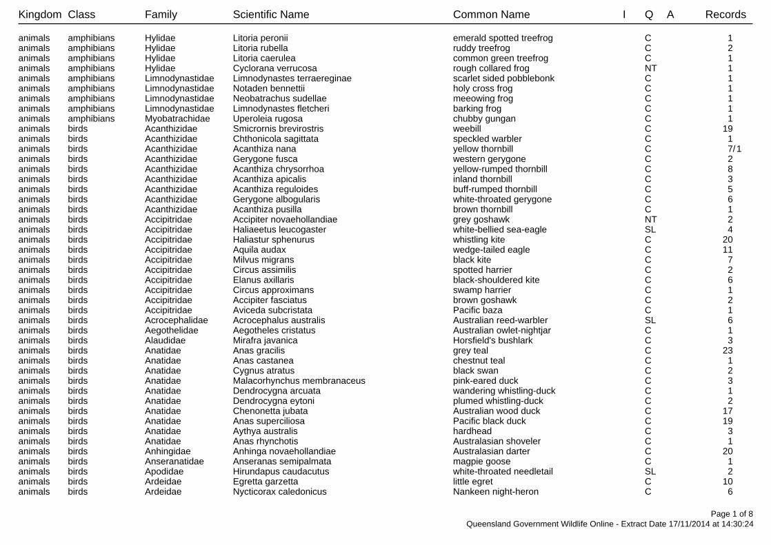
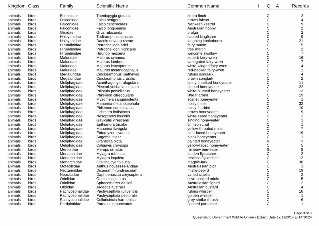
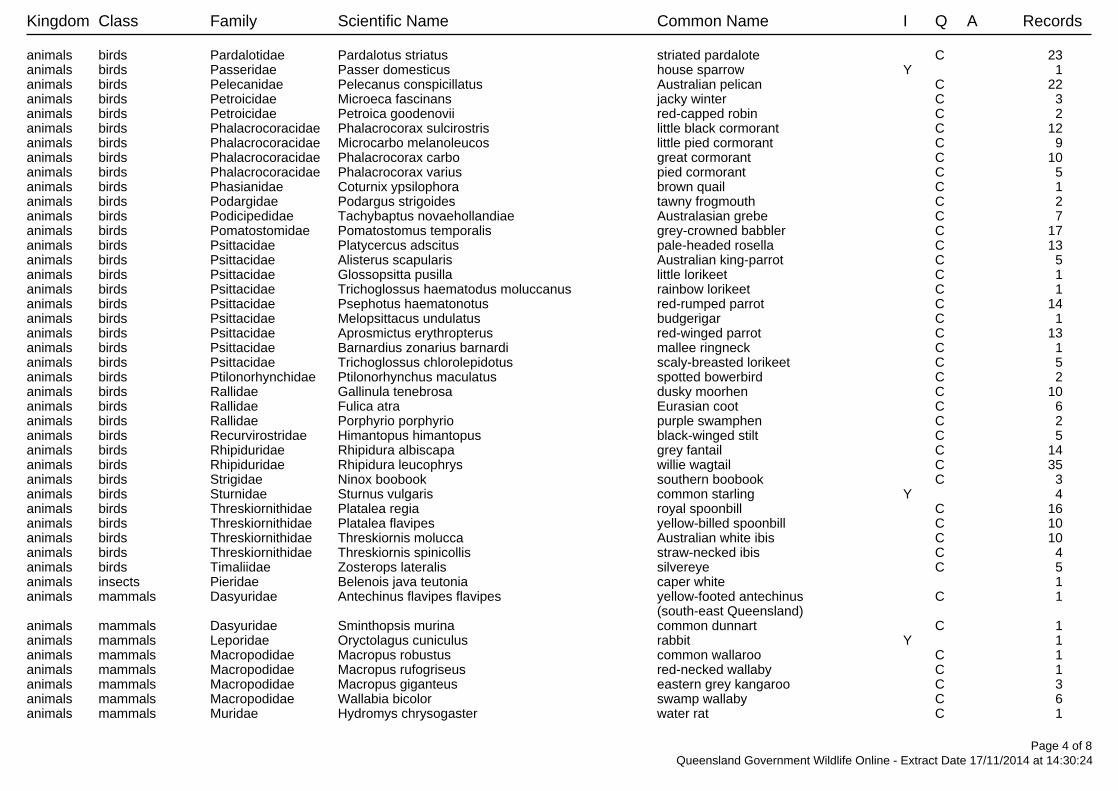
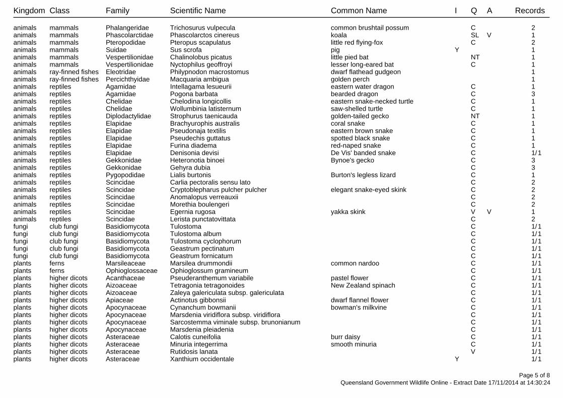
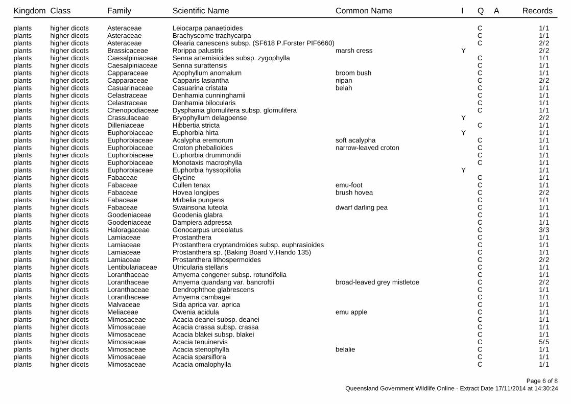
Kingdom Class Family Scientific Name Common Name I Q A Records
animals amphibians Hylidae Litoria peronii emerald spotted treefrog C 1 animals amphibians Hylidae Litoria rubella ruddy treefrog C 2 animals amphibians Hylidae Litoria caerulea common green treefrog C 1 animals amphibians Hylidae Cyclorana verrucosa rough collared frog NT 1 animals amphibians Limnodynastidae Limnodynastes terraereginae scarlet sided pobblebonk C 1 animals amphibians Limnodynastidae Notaden bennettii holy cross frog C 1 animals amphibians Limnodynastidae Neobatrachus sudellae meeowing frog C 1 animals amphibians Limnodynastidae Limnodynastes fletcheri barking frog C 1 animals amphibians Myobatrachidae Uperoleia rugosa chubby gungan C 1 animals birds Acanthizidae Smicrornis brevirostris weebill C 19 animals birds Acanthizidae Chthonicola sagittata speckled warbler C 1 animals birds Acanthizidae Acanthiza nana yellow thornbill C 7/1animals birds Acanthizidae Gerygone fusca western gerygone C 2 animals birds Acanthizidae Acanthiza chrysorrhoa yellow-rumped thornbill C 8 animals birds Acanthizidae Acanthiza apicalis inland thornbill C 3 animals birds Acanthizidae Acanthiza reguloides buff-rumped thornbill C 5 animals birds Acanthizidae Gerygone albogularis white-throated gerygone C 6 animals birds Acanthizidae Acanthiza pusilla brown thornbill C 1 animals birds Accipitridae Accipiter novaehollandiae grey goshawk NT 2 animals birds Accipitridae Haliaeetus leucogaster white-bellied sea-eagle SL 4 animals birds Accipitridae Haliastur sphenurus whistling kite C 20 animals birds Accipitridae Aquila audax wedge-tailed eagle C 11 animals birds Accipitridae Milvus migrans black kite C 7 animals birds Accipitridae Circus assimilis spotted harrier C 2 animals birds Accipitridae Elanus axillaris black-shouldered kite C 6 animals birds Accipitridae Circus approximans swamp harrier C 1 animals birds Accipitridae Accipiter fasciatus brown goshawk C 2 animals birds Accipitridae Aviceda subcristata Pacific baza C 1 animals birds Acrocephalidae Acrocephalus australis Australian reed-warbler SL 6 animals birds Aegothelidae Aegotheles cristatus Australian owlet-nightjar C 1 animals birds Alaudidae Mirafra javanica Horsfield's bushlark C 3 animals birds Anatidae Anas gracilis grey teal C 23 animals birds Anatidae Anas castanea chestnut teal C 1 animals birds Anatidae Cygnus atratus black swan C 2 animals birds Anatidae Malacorhynchus membranaceus pink-eared duck C 3 animals birds Anatidae Dendrocygna arcuata wandering whistling-duck C 1 animals birds Anatidae Dendrocygna eytoni plumed whistling-duck C 2 animals birds Anatidae Chenonetta jubata Australian wood duck C 17 animals birds Anatidae Anas superciliosa Pacific black duck C 19 animals birds Anatidae Aythya australis hardhead C 3 animals birds Anatidae Anas rhynchotis Australasian shoveler C 1 animals birds Anhingidae Anhinga novaehollandiae Australasian darter C 20 animals birds Anseranatidae Anseranas semipalmata magpie goose C 1 animals birds Apodidae Hirundapus caudacutus white-throated needletail SL 2 animals birds Ardeidae Egretta garzetta little egret C 10 animals birds Ardeidae Nycticorax caledonicus Nankeen night-heron C 6
Page 1 of 8Queensland Government Wildlife Online - Extract Date 17/11/2014 at 14:30:24
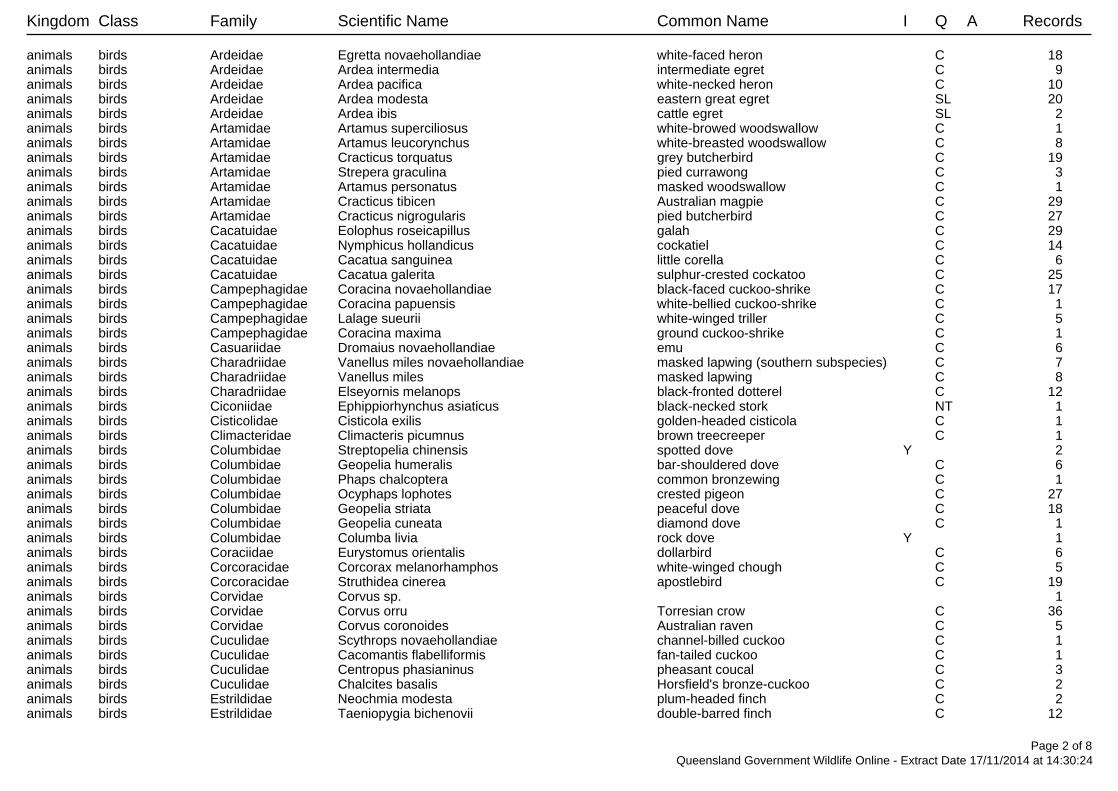
Kingdom Class Family Scientific Name Common Name I Q A Records
animals birds Ardeidae Egretta novaehollandiae white-faced heron C 18 animals birds Ardeidae Ardea intermedia intermediate egret C 9 animals birds Ardeidae Ardea pacifica white-necked heron C 10 animals birds Ardeidae Ardea modesta eastern great egret SL 20 animals birds Ardeidae Ardea ibis cattle egret SL 2 animals birds Artamidae Artamus superciliosus white-browed woodswallow C 1 animals birds Artamidae Artamus leucorynchus white-breasted woodswallow C 8 animals birds Artamidae Cracticus torquatus grey butcherbird C 19 animals birds Artamidae Strepera graculina pied currawong C 3 animals birds Artamidae Artamus personatus masked woodswallow C 1 animals birds Artamidae Cracticus tibicen Australian magpie C 29 animals birds Artamidae Cracticus nigrogularis pied butcherbird C 27 animals birds Cacatuidae Eolophus roseicapillus galah C 29 animals birds Cacatuidae Nymphicus hollandicus cockatiel C 14 animals birds Cacatuidae Cacatua sanguinea little corella C 6 animals birds Cacatuidae Cacatua galerita sulphur-crested cockatoo C 25 animals birds Campephagidae Coracina novaehollandiae black-faced cuckoo-shrike C 17 animals birds Campephagidae Coracina papuensis white-bellied cuckoo-shrike C 1 animals birds Campephagidae Lalage sueurii white-winged triller C 5 animals birds Campephagidae Coracina maxima ground cuckoo-shrike C 1 animals birds Casuariidae Dromaius novaehollandiae emu C 6 animals birds Charadriidae Vanellus miles novaehollandiae masked lapwing (southern subspecies) C 7 animals birds Charadriidae Vanellus miles masked lapwing C 8 animals birds Charadriidae Elseyornis melanops black-fronted dotterel C 12 animals birds Ciconiidae Ephippiorhynchus asiaticus black-necked stork NT 1 animals birds Cisticolidae Cisticola exilis golden-headed cisticola C 1 animals birds Climacteridae Climacteris picumnus brown treecreeper C 1 animals birds Columbidae Streptopelia chinensis spotted dove Y 2 animals birds Columbidae Geopelia humeralis bar-shouldered dove C 6 animals birds Columbidae Phaps chalcoptera common bronzewing C 1 animals birds Columbidae Ocyphaps lophotes crested pigeon C 27 animals birds Columbidae Geopelia striata peaceful dove C 18 animals birds Columbidae Geopelia cuneata diamond dove C 1 animals birds Columbidae Columba livia rock dove Y 1 animals birds Coraciidae Eurystomus orientalis dollarbird C 6 animals birds Corcoracidae Corcorax melanorhamphos white-winged chough C 5 animals birds Corcoracidae Struthidea cinerea apostlebird C 19 animals birds Corvidae Corvus sp. 1 animals birds Corvidae Corvus orru Torresian crow C 36 animals birds Corvidae Corvus coronoides Australian raven C 5 animals birds Cuculidae Scythrops novaehollandiae channel-billed cuckoo C 1 animals birds Cuculidae Cacomantis flabelliformis fan-tailed cuckoo C 1 animals birds Cuculidae Centropus phasianinus pheasant coucal C 3 animals birds Cuculidae Chalcites basalis Horsfield's bronze-cuckoo C 2 animals birds Estrildidae Neochmia modesta plum-headed finch C 2 animals birds Estrildidae Taeniopygia bichenovii double-barred finch C 12
Page 2 of 8Queensland Government Wildlife Online - Extract Date 17/11/2014 at 14:30:24
Kingdom Class Family Scientific Name Common Name I Q A Records
animals birds Estrildidae Taeniopygia guttata zebra finch C 2 animals birds Falconidae Falco berigora brown falcon C 4 animals birds Falconidae Falco cenchroides Nankeen kestrel C 9 animals birds Falconidae Falco longipennis Australian hobby C 2 animals birds Gruidae Grus rubicunda brolga C 2 animals birds Halcyonidae Todiramphus sanctus sacred kingfisher C 9 animals birds Halcyonidae Dacelo novaeguineae laughing kookaburra C 21 animals birds Hirundinidae Petrochelidon ariel fairy martin C 5 animals birds Hirundinidae Petrochelidon nigricans tree martin C 2 animals birds Hirundinidae Hirundo neoxena welcome swallow C 7 animals birds Maluridae Malurus cyaneus superb fairy-wren C 16 animals birds Maluridae Malurus lamberti variegated fairy-wren C 7 animals birds Maluridae Malurus leucopterus white-winged fairy-wren C 4 animals birds Maluridae Malurus melanocephalus red-backed fairy-wren C 1 animals birds Megaluridae Cincloramphus mathewsi rufous songlark C 4 animals birds Megaluridae Cincloramphus cruralis brown songlark C 2 animals birds Meliphagidae Acanthagenys rufogularis spiny-cheeked honeyeater C 11 animals birds Meliphagidae Plectorhyncha lanceolata striped honeyeater C 22 animals birds Meliphagidae Ptilotula penicillatus white-plumed honeyeater C 13 animals birds Meliphagidae Philemon citreogularis little friarbird C 19 animals birds Meliphagidae Myzomela sanguinolenta scarlet honeyeater C 1 animals birds Meliphagidae Manorina melanocephala noisy miner C 32 animals birds Meliphagidae Philemon corniculatus noisy friarbird C 10 animals birds Meliphagidae Lichmera indistincta brown honeyeater C 9 animals birds Meliphagidae Nesoptilotis leucotis white-eared honeyeater C 2 animals birds Meliphagidae Gavicalis virescens singing honeyeater C 1 animals birds Meliphagidae Epthianura tricolor crimson chat C 1 animals birds Meliphagidae Manorina flavigula yellow-throated miner C 7 animals birds Meliphagidae Entomyzon cyanotis blue-faced honeyeater C 19 animals birds Meliphagidae Sugomel niger black honeyeater C 1 animals birds Meliphagidae Grantiella picta painted honeyeater V 3 animals birds Meliphagidae Caligavis chrysops yellow-faced honeyeater C 5 animals birds Meropidae Merops ornatus rainbow bee-eater SL 8 animals birds Monarchidae Myiagra rubecula leaden flycatcher C 2 animals birds Monarchidae Myiagra inquieta restless flycatcher C 12 animals birds Monarchidae Grallina cyanoleuca magpie-lark C 38 animals birds Motacillidae Anthus novaeseelandiae Australasian pipit C 1 animals birds Nectariniidae Dicaeum hirundinaceum mistletoebird C 19 animals birds Neosittidae Daphoenositta chrysoptera varied sittella C 2 animals birds Oriolidae Oriolus sagittatus olive-backed oriole C 5 animals birds Oriolidae Sphecotheres vieilloti Australasian figbird C 2 animals birds Otididae Ardeotis australis Australian bustard C 4 animals birds Pachycephalidae Pachycephala rufiventris rufous whistler C 18 animals birds Pachycephalidae Pachycephala pectoralis golden whistler C 1 animals birds Pachycephalidae Colluricincla harmonica grey shrike-thrush C 6 animals birds Pardalotidae Pardalotus punctatus spotted pardalote C 1
Page 3 of 8Queensland Government Wildlife Online - Extract Date 17/11/2014 at 14:30:24
Kingdom Class Family Scientific Name Common Name I Q A Records
animals birds Pardalotidae Pardalotus striatus striated pardalote C 23 animals birds Passeridae Passer domesticus house sparrow Y 1 animals birds Pelecanidae Pelecanus conspicillatus Australian pelican C 22 animals birds Petroicidae Microeca fascinans jacky winter C 3 animals birds Petroicidae Petroica goodenovii red-capped robin C 2 animals birds Phalacrocoracidae Phalacrocorax sulcirostris little black cormorant C 12 animals birds Phalacrocoracidae Microcarbo melanoleucos little pied cormorant C 9 animals birds Phalacrocoracidae Phalacrocorax carbo great cormorant C 10 animals birds Phalacrocoracidae Phalacrocorax varius pied cormorant C 5 animals birds Phasianidae Coturnix ypsilophora brown quail C 1 animals birds Podargidae Podargus strigoides tawny frogmouth C 2 animals birds Podicipedidae Tachybaptus novaehollandiae Australasian grebe C 7 animals birds Pomatostomidae Pomatostomus temporalis grey-crowned babbler C 17 animals birds Psittacidae Platycercus adscitus pale-headed rosella C 13 animals birds Psittacidae Alisterus scapularis Australian king-parrot C 5 animals birds Psittacidae Glossopsitta pusilla little lorikeet C 1 animals birds Psittacidae Trichoglossus haematodus moluccanus rainbow lorikeet C 1 animals birds Psittacidae Psephotus haematonotus red-rumped parrot C 14 animals birds Psittacidae Melopsittacus undulatus budgerigar C 1 animals birds Psittacidae Aprosmictus erythropterus red-winged parrot C 13 animals birds Psittacidae Barnardius zonarius barnardi mallee ringneck C 1 animals birds Psittacidae Trichoglossus chlorolepidotus scaly-breasted lorikeet C 5 animals birds Ptilonorhynchidae Ptilonorhynchus maculatus spotted bowerbird C 2 animals birds Rallidae Gallinula tenebrosa dusky moorhen C 10 animals birds Rallidae Fulica atra Eurasian coot C 6 animals birds Rallidae Porphyrio porphyrio purple swamphen C 2 animals birds Recurvirostridae Himantopus himantopus black-winged stilt C 5 animals birds Rhipiduridae Rhipidura albiscapa grey fantail C 14 animals birds Rhipiduridae Rhipidura leucophrys willie wagtail C 35 animals birds Strigidae Ninox boobook southern boobook C 3 animals birds Sturnidae Sturnus vulgaris common starling Y 4 animals birds Threskiornithidae Platalea regia royal spoonbill C 16 animals birds Threskiornithidae Platalea flavipes yellow-billed spoonbill C 10 animals birds Threskiornithidae Threskiornis molucca Australian white ibis C 10 animals birds Threskiornithidae Threskiornis spinicollis straw-necked ibis C 4 animals birds Timaliidae Zosterops lateralis silvereye C 5 animals insects Pieridae Belenois java teutonia caper white 1 animals mammals Dasyuridae Antechinus flavipes flavipes yellow-footed antechinus C 1
(south-east Queensland)animals mammals Dasyuridae Sminthopsis murina common dunnart C 1 animals mammals Leporidae Oryctolagus cuniculus rabbit Y 1 animals mammals Macropodidae Macropus robustus common wallaroo C 1 animals mammals Macropodidae Macropus rufogriseus red-necked wallaby C 1 animals mammals Macropodidae Macropus giganteus eastern grey kangaroo C 3 animals mammals Macropodidae Wallabia bicolor swamp wallaby C 6 animals mammals Muridae Hydromys chrysogaster water rat C 1
Page 4 of 8Queensland Government Wildlife Online - Extract Date 17/11/2014 at 14:30:24
Kingdom Class Family Scientific Name Common Name I Q A Records
animals mammals Phalangeridae Trichosurus vulpecula common brushtail possum C 2 animals mammals Phascolarctidae Phascolarctos cinereus koala SL V 1 animals mammals Pteropodidae Pteropus scapulatus little red flying-fox C 2 animals mammals Suidae Sus scrofa pig Y 1 animals mammals Vespertilionidae Chalinolobus picatus little pied bat NT 1 animals mammals Vespertilionidae Nyctophilus geoffroyi lesser long-eared bat C 1 animals ray-finned fishes Eleotridae Philypnodon macrostomus dwarf flathead gudgeon 1 animals ray-finned fishes Percichthyidae Macquaria ambigua golden perch 1 animals reptiles Agamidae Intellagama lesueurii eastern water dragon C 1 animals reptiles Agamidae Pogona barbata bearded dragon C 3 animals reptiles Chelidae Chelodina longicollis eastern snake-necked turtle C 1 animals reptiles Chelidae Wollumbinia latisternum saw-shelled turtle C 1 animals reptiles Diplodactylidae Strophurus taenicauda golden-tailed gecko NT 1 animals reptiles Elapidae Brachyurophis australis coral snake C 1 animals reptiles Elapidae Pseudonaja textilis eastern brown snake C 1 animals reptiles Elapidae Pseudechis guttatus spotted black snake C 1 animals reptiles Elapidae Furina diadema red-naped snake C 1 animals reptiles Elapidae Denisonia devisi De Vis' banded snake C 1/1animals reptiles Gekkonidae Heteronotia binoei Bynoe's gecko C 3 animals reptiles Gekkonidae Gehyra dubia C 3 animals reptiles Pygopodidae Lialis burtonis Burton's legless lizard C 1 animals reptiles Scincidae Carlia pectoralis sensu lato C 2 animals reptiles Scincidae Cryptoblepharus pulcher pulcher elegant snake-eyed skink C 2 animals reptiles Scincidae Anomalopus verreauxii C 2 animals reptiles Scincidae Morethia boulengeri C 2 animals reptiles Scincidae Egernia rugosa yakka skink V V 1 animals reptiles Scincidae Lerista punctatovittata C 2 fungi club fungi Basidiomycota Tulostoma C 1/1fungi club fungi Basidiomycota Tulostoma album C 1/1fungi club fungi Basidiomycota Tulostoma cyclophorum C 1/1fungi club fungi Basidiomycota Geastrum pectinatum C 1/1fungi club fungi Basidiomycota Geastrum fornicatum C 1/1plants ferns Marsileaceae Marsilea drummondii common nardoo C 1/1plants ferns Ophioglossaceae Ophioglossum gramineum C 1/1plants higher dicots Acanthaceae Pseuderanthemum variabile pastel flower C 1/1plants higher dicots Aizoaceae Tetragonia tetragonoides New Zealand spinach C 1/1plants higher dicots Aizoaceae Zaleya galericulata subsp. galericulata C 1/1plants higher dicots Apiaceae Actinotus gibbonsii dwarf flannel flower C 1/1plants higher dicots Apocynaceae Cynanchum bowmanii bowman's milkvine C 1/1plants higher dicots Apocynaceae Marsdenia viridiflora subsp. viridiflora C 1/1plants higher dicots Apocynaceae Sarcostemma viminale subsp. brunonianum C 1/1plants higher dicots Apocynaceae Marsdenia pleiadenia C 1/1plants higher dicots Asteraceae Calotis cuneifolia burr daisy C 1/1plants higher dicots Asteraceae Minuria integerrima smooth minuria C 1/1plants higher dicots Asteraceae Rutidosis lanata V 1/1plants higher dicots Asteraceae Xanthium occidentale Y 1/1
Page 5 of 8Queensland Government Wildlife Online - Extract Date 17/11/2014 at 14:30:24
Kingdom Class Family Scientific Name Common Name I Q A Records
plants higher dicots Asteraceae Leiocarpa panaetioides C 1/1plants higher dicots Asteraceae Brachyscome trachycarpa C 1/1plants higher dicots Asteraceae Olearia canescens subsp. (SF618 P.Forster PIF6660) C 2/2plants higher dicots Brassicaceae Rorippa palustris marsh cress Y 2/2plants higher dicots Caesalpiniaceae Senna artemisioides subsp. zygophylla C 1/1plants higher dicots Caesalpiniaceae Senna surattensis C 1/1plants higher dicots Capparaceae Apophyllum anomalum broom bush C 1/1plants higher dicots Capparaceae Capparis lasiantha nipan C 2/2plants higher dicots Casuarinaceae Casuarina cristata belah C 1/1plants higher dicots Celastraceae Denhamia cunninghamii C 1/1plants higher dicots Celastraceae Denhamia bilocularis C 1/1plants higher dicots Chenopodiaceae Dysphania glomulifera subsp. glomulifera C 1/1plants higher dicots Crassulaceae Bryophyllum delagoense Y 2/2plants higher dicots Dilleniaceae Hibbertia stricta C 1/1plants higher dicots Euphorbiaceae Euphorbia hirta Y 1/1plants higher dicots Euphorbiaceae Acalypha eremorum soft acalypha C 1/1plants higher dicots Euphorbiaceae Croton phebalioides narrow-leaved croton C 1/1plants higher dicots Euphorbiaceae Euphorbia drummondii C 1/1plants higher dicots Euphorbiaceae Monotaxis macrophylla C 1/1plants higher dicots Euphorbiaceae Euphorbia hyssopifolia Y 1/1plants higher dicots Fabaceae Glycine C 1/1plants higher dicots Fabaceae Cullen tenax emu-foot C 1/1plants higher dicots Fabaceae Hovea longipes brush hovea C 2/2plants higher dicots Fabaceae Mirbelia pungens C 1/1plants higher dicots Fabaceae Swainsona luteola dwarf darling pea C 1/1plants higher dicots Goodeniaceae Goodenia glabra C 1/1plants higher dicots Goodeniaceae Dampiera adpressa C 1/1plants higher dicots Haloragaceae Gonocarpus urceolatus C 3/3plants higher dicots Lamiaceae Prostanthera C 1/1plants higher dicots Lamiaceae Prostanthera cryptandroides subsp. euphrasioides C 1/1plants higher dicots Lamiaceae Prostanthera sp. (Baking Board V.Hando 135) C 1/1plants higher dicots Lamiaceae Prostanthera lithospermoides C 2/2plants higher dicots Lentibulariaceae Utricularia stellaris C 1/1plants higher dicots Loranthaceae Amyema congener subsp. rotundifolia C 1/1plants higher dicots Loranthaceae Amyema quandang var. bancroftii broad-leaved grey mistletoe C 2/2plants higher dicots Loranthaceae Dendrophthoe glabrescens C 1/1plants higher dicots Loranthaceae Amyema cambagei C 1/1plants higher dicots Malvaceae Sida aprica var. aprica C 1/1plants higher dicots Meliaceae Owenia acidula emu apple C 1/1plants higher dicots Mimosaceae Acacia deanei subsp. deanei C 1/1plants higher dicots Mimosaceae Acacia crassa subsp. crassa C 1/1plants higher dicots Mimosaceae Acacia blakei subsp. blakei C 1/1plants higher dicots Mimosaceae Acacia tenuinervis C 5/5plants higher dicots Mimosaceae Acacia stenophylla belalie C 1/1plants higher dicots Mimosaceae Acacia sparsiflora C 1/1plants higher dicots Mimosaceae Acacia omalophylla C 1/1
Page 6 of 8Queensland Government Wildlife Online - Extract Date 17/11/2014 at 14:30:24
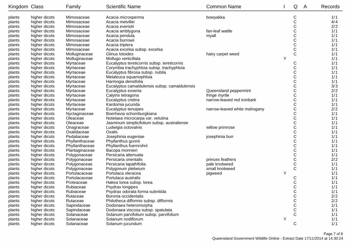
Kingdom Class Family Scientific Name Common Name I Q A Records
plants higher dicots Mimosaceae Acacia microsperma bowyakka C 1/1plants higher dicots Mimosaceae Acacia melvillei C 4/4plants higher dicots Mimosaceae Acacia everistii C 2/2plants higher dicots Mimosaceae Acacia amblygona fan-leaf wattle C 1/1plants higher dicots Mimosaceae Acacia pendula myall C 1/1plants higher dicots Mimosaceae Acacia burrowii C 1/1plants higher dicots Mimosaceae Acacia triptera C 1/1plants higher dicots Mimosaceae Acacia excelsa subsp. excelsa C 1/1plants higher dicots Molluginaceae Glinus lotoides hairy carpet weed C 1/1plants higher dicots Molluginaceae Mollugo verticillata Y 1/1plants higher dicots Myrtaceae Eucalyptus tereticornis subsp. tereticornis C 1/1plants higher dicots Myrtaceae Corymbia trachyphloia subsp. trachyphloia C 1/1plants higher dicots Myrtaceae Eucalyptus fibrosa subsp. nubila C 1/1plants higher dicots Myrtaceae Melaleuca squamophloia C 1/1plants higher dicots Myrtaceae Harmogia densifolia C 1/1plants higher dicots Myrtaceae Eucalyptus camaldulensis subsp. camaldulensis C 3/3plants higher dicots Myrtaceae Eucalyptus exserta Queensland peppermint C 2/2plants higher dicots Myrtaceae Calytrix tetragona fringe myrtle C 1/1plants higher dicots Myrtaceae Eucalyptus crebra narrow-leaved red ironbark C 1/1plants higher dicots Myrtaceae Kardomia jucunda C 1/1plants higher dicots Myrtaceae Eucalyptus tenuipes narrow-leaved white mahogany C 2/2plants higher dicots Nyctaginaceae Boerhavia schomburgkiana C 1/1plants higher dicots Oleaceae Notelaea microcarpa var. velutina C 1/1plants higher dicots Oleaceae Jasminum simplicifolium subsp. australiense C 1/1plants higher dicots Onagraceae Ludwigia octovalvis willow primrose C 1/1plants higher dicots Oxalidaceae Oxalis C 1/1plants higher dicots Pedaliaceae Josephinia eugeniae josephinia burr C 1/1plants higher dicots Phyllanthaceae Phyllanthus gunnii C 1/1plants higher dicots Phyllanthaceae Phyllanthus fuernrohrii C 1/1plants higher dicots Plantaginaceae Bacopa monnieri C 1/1plants higher dicots Polygonaceae Persicaria attenuata C 1/1plants higher dicots Polygonaceae Persicaria orientalis princes feathers C 2/2plants higher dicots Polygonaceae Persicaria lapathifolia pale knotweed C 1/1plants higher dicots Polygonaceae Polygonum plebeium small knotweed C 1/1plants higher dicots Portulacaceae Portulaca oleracea pigweed Y 1/1plants higher dicots Portulacaceae Portulaca australis C 1/1plants higher dicots Proteaceae Hakea lorea subsp. lorea C 1/1plants higher dicots Rubiaceae Psydrax longipes C 1/1plants higher dicots Rubiaceae Psydrax odorata forma subnitida C 1/1plants higher dicots Rutaceae Boronia occidentalis C 2/2plants higher dicots Rutaceae Philotheca difformis subsp. difformis C 2/2plants higher dicots Sapindaceae Dodonaea heteromorpha C 1/1plants higher dicots Sapindaceae Dodonaea viscosa subsp. spatulata C 1/1plants higher dicots Solanaceae Solanum parvifolium subsp. parvifolium C 1/1plants higher dicots Solanaceae Solanum nodiflorum Y 1/1plants higher dicots Solanaceae Solanum jucundum C 1/1
Page 7 of 8Queensland Government Wildlife Online - Extract Date 17/11/2014 at 14:30:24
Kingdom Class Family Scientific Name Common Name I Q A Records
plants higher dicots Solanaceae Duboisia leichhardtii C 1/1plants higher dicots Sparrmanniaceae Corchorus trilocularis C 1/1plants higher dicots Verbenaceae Phyla canescens Y 1/1plants higher dicots Viscaceae Viscum articulatum flat mistletoe C 1/1plants higher dicots Viscaceae Viscum whitei subsp. whitei C 1/1plants lower dicots Ranunculaceae Clematis C 1/1plants monocots Aponogetonaceae Aponogeton queenslandicus C 1/1plants monocots Cyperaceae Schoenoplectus dissachanthus C 1/1plants monocots Cyperaceae Cyperus betchei subsp. betchei C 1/1plants monocots Cyperaceae Cyperus iria C 1/1plants monocots Cyperaceae Cyperus procerus C 1/1plants monocots Cyperaceae Eleocharis pusilla small spikerush C 1/1plants monocots Cyperaceae Cyperus gymnocaulos spiny flatsedge C 1/1plants monocots Hemerocallidaceae Dianella brevipedunculata C 1/1plants monocots Hemerocallidaceae Dianella revoluta var. revoluta C 2/2plants monocots Hemerocallidaceae Dianella brevipedunculata x D.revoluta C 1/1
var. revolutaplants monocots Orchidaceae Pterostylis C 1/1plants monocots Poaceae Enneapogon gracilis slender nineawn C 1/1plants monocots Poaceae Walwhalleya subxerophila C 1/1plants monocots Poaceae Sporobolus caroli fairy grass C 1/1plants monocots Poaceae Sporobolus creber C 1/1plants monocots Poaceae Diplachne fusca var. fusca C 1/1plants monocots Poaceae Enteropogon ramosus C 1/1plants monocots Poaceae Paspalidium distans shotgrass C 1/1plants monocots Poaceae Sporobolus disjunctus C 1/1plants monocots Poaceae Enteropogon acicularis curly windmill grass C 1/1plants monocots Poaceae Dinebra divaricatissima C 1/1plants monocots Poaceae Sporobolus actinocladus katoora grass C 1/1plants mosses Bryophyte Bryophyte C 1/1plants mosses Pottiaceae Barbula calycina C 1/1plants Linderniaceae Lindernia alsinoides C 1/1
CODES
I - Y indicates that the taxon is introduced to Queensland and has naturalised.
Q - Indicates the Queensland conservation status of each taxon under the Nature Conservation Act 1992. The codes are Extinct in the Wild (PE), Endangered (E),Vulnerable (V), Near Threatened (NT), Least Concern (C) or Not Protected ( ).
A - Indicates the Australian conservation status of each taxon under the Environment Protection and Biodiversity Conservation Act 1999. The values of EPBC areConservation Dependent (CD), Critically Endangered (CE), Endangered (E), Extinct (EX), Extinct in the Wild (XW) and Vulnerable (V).
Records – The first number indicates the total number of records of the taxon for the record option selected (i.e. All, Confirmed or Specimens).This number is output as 99999 if it equals or exceeds this value. The second number located after the / indicates the number of specimen records for the taxon.This number is output as 999 if it equals or exceeds this value.
Page 8 of 8Queensland Government Wildlife Online - Extract Date 17/11/2014 at 14:30:24
GHD | Report for Origin Energy - DA1644, 41/28330
Appendix D – DEHP Certified Regional Ecosystem Mapping
145 Ann Street Brisbane QLD 4000 Australia T 61 7 3316 3000 F 61 7 3316 3333 E [email protected] W www.ghd.com
11.5.1/11.7.5/11.7.290/5/5
11.9.5/11.9.750/50
11.3.25/11.3.4/11.3.380/10/10
11.9.5/11.9.750/50
11.9.5100
11.9.5/11.9.750/50
11.9.5100
SHERIFFS ROAD
GREENSWAMP ROAD
LEBSANFTS ROAD
50BWR477
51BWR126
249,000
249,000
249,500
249,500
250,000
250,000
250,500
250,500
251,000
251,000
251,500
251,500
252,000
252,000
252,500
252,500
253,000
253,000
253,500
253,500
7,034,
000
7,034,
000
7,034,
500
7,034,
500
7,035,
000
7,035,
000
7,035,
500
7,035,
500
7,036,
000
7,036,
000
7,036,
500
7,036,
500
G:\41\28330\GIS\Maps\MXD\41_28330_018_Pascoe_Sur_rev_0.mxd© 2015. Whilst every care has been taken to prepare this map, GHD and DNRM make no representations or warranties about its accuracy, reliability, completeness or suitability for any particular purpose and cannot accept liability and responsibility of any kind (whether in contract, tort or otherwise) for any expenses, losses, damages and/or costs (including indirect or consequential damage) which are or may be incurred by any party as a result of the map being inaccurate, incomplete or unsuitable in any way and for any reason.
LEGEND0 250 500125
MetresMap Projection: Transverse Mercator
Horizontal Datum: GDA 1994Grid: GDA 1994 MGA Zone 56
Origin EnergyEcological Assessment Report
Figure 3
Job NumberRevision 0
41-28330
30 Jan 2015
DEHP Certified RegionalEcosystem Mappingo Date
Data source: DNRM: Ordered Drainage, 2010; Baseline Roads, Petroleum Lease,Regional Ecosystem v8 2014; Origin Energy: Imagery, Cadastre 2014; GHD: Survey Area, 2014. Created by: RB
Paper Size A3Local Road
Ordered streams1
23
Lot Boundaries Within Study AreaLot Boundaries Outside Study Area
Survey AreaPetroleum Lease
RemnantEndangered REOf Concern RENo Concern at Present
Based on or contains data provided by the State of QLD (DNRM) [2014]. In consideration of the Statepermitting use of this data you acknowledge and agree that the State gives no warranty in relationto the data (including accuracy, reliability, completeness, currency or suitability) and accepts no liability(including without limitation, liability in negligence) for any loss, damage or costs (including conse-quential damage) relating to any use of the data. Data must not be used for marketing or be used inbreach of the privacy laws.

GHD | Report for Origin Energy - DA1644, 41/28330
Appendix E – DEHP Mapped Environmentally Sensitive Areas
\\
\\
\\
\\
\\\
\\
\\
\
\
\\
\\\
\\ \
\\
\\
\\ \
\
\
\ \
\
\
\
\
\
\
\\
\\
\
\
\
\
\
\
\\
\
\\
\\
\ \\
\\\
\
\
\
\
\\ \\ \
\\
\
\\
\\
\
\\
\\
\
\ \\
\\
\
\\
\\
\\
\\\
\
\\
\
\ \
\\
\
\
\
\
\\\
\\
\
\\
\
\
\
\
\\
\
\
\
\
\\\
\
\
\\
\
\\\
\ \
\\
\
\
\
\\
\\\
\
\\
\
\\
\\\
\
\\
\
\
\
\
\
\
\
\
\
\
\
\
\
\
\
\
\
\
\
\
\
\
\
\\
\ \
\ \
\
\\
\
\
\
\
\ \
\\\
\
\
\\
\
\
\
\\
\
\\\
\\\
\
\
\
\\\ \\\
\
\\
\
\\
\
\
\
\
\\ \
\
\\
\
\\
\\
\\\\\
\\\
\
\\
\
\\
\
\\\
\
\\
\
\
\
\\
\\
\\
\\ \
\\
\
\
\
\\
\\\\
\\
\\\
\
\ \
\\
\
\
\
\
\
\
\
\
\
\\
\\
\
\
\
\
\
\
\\
\\
\
\
\\\\
\\\
\
\\
##
!CHINCHILLA
PL272
PL226
PL185
PL179
PL253PL
229
PL458
PL459
150 °36 '0 "E
150 °36 '0 "E
150 °34 '0 "E
150 °34 '0 "E
150 °32 '0 "E
150 °32 '0 "E
150 °30 '0 "E
150 °30 '0 "E
150 °28 '0 "E
150 °28 '0 "E
150 °26 '0 "E
150 °26 '0 "E
150 °24 '0 "E
150 °24 '0 "E26
°42'0
"S
26°4
2'0"S
26°4
4'0"S
26°4
4'0"S
26°4
6'0"S
26°4
6'0"S
26°4
8'0"S
26°4
8'0"S
26°5
0'0"S
26°5
0'0"S
26°5
2'0"S
26°5
2'0"S
ENVIRONMENTALLY SENSITIVE AREAS - non-mining resource activities (EP Act)
¯© The S tate of Queensland, 2014
Requested By: [email protected]: 30 Oct 14 Time: 16.22.41
Centred on point position:Latitude: -26.7875 Longitude: 150.5041
(decimal degrees)
This product is projected into GDA 1994 MGA Zone 56
0 1300 2600 3900 5200 6500 m
LOCALITY D IAGRAM
Petroleum LeasesCATEGORY ANational ParksRegional Parks (general)Forest ReservesWet Tropics World HeritageAreaGreat Barrier Reef Marine Park AreaMarine Parks other than General Use ZonesCATEGORY BWorld Heritage AreasQueensland Heritage Register PlacesRamsar S itesCultural HeritageRegistered Areasand DLA's otherthan StanbrokeSpecial Forestry AreasFish Habitat AreasKoala P lanCoordinated Conservation AreasEndangered Regional Ecosystems (remnant and mature regrowth(biodiversity status))Marine Parks other than General Use ZonesMarine Plants
CATEGORY CEssential HabitatNature RefugesRegional Parks (resource use area)State ForestsTimber ReservesOf Concern Regional Ecosystems(remnant biodiversity status)OTHERS
! TownsRoads© Pitney Bowes Software Pty LtdRivers
# Springs\ \\
\
\\\\
\
\
\
\
\
\
\\
\\ \ Referable WetlandsDominant Wetlands (51-100%)Subdominant Wetlands (0-50%)Queensland
2014
NOTE TO USER: Themes presented in this map are indicative only. Field survey may berequired to verify the 'true' spatia l extent and value. Not all environmentally sensitiveareas are presented in this map. A user should refer to the particular circumstancesrelevant to their situation to assess the 'completeness' of themes provided.The user should note that some boundaries and indicated values are ambient or subjectto change over time (e.g. regional ecosystem boundaries and conservation status,watercourse mapping etc).The user should be aware that due to multiple overlapping themes present, somethemes/layers may be obscured by others. Ordering in the Legend does not accuratelyreflect the order by which themes are displayed.Mature Regrowth vegetation, depicting endangered regional ecosystems, wasincorporated as of 24/07/2012.
Information presented on this product is distributed by the QueenslandGovernment as an information source only. While every care is taken toensure the accuracy of this data, Pitney Bowes Software and the State ofQueensland makes no statements, representations or warranties aboutthe accuracy, reliabil ity, completeness or suitabil ity of any informationcontained in this product.
The State of Queensland disclaims all responsibility for informationcontained in this product and all liability (including without limitation,liabil ity in negligence) for all expenses, losses, damages and costs youmay incur as a result of the information being inaccurate or ncomplete inany way for any reason.
External contributors (non-government parties) of the data for this productare: Great Barrier Reef Marine Park Authority and Pitney Bowes SoftwareRegional ecosystem mapping (remnant biodiversity status) mayincorporate amendments, resulting from property level assessments,to the release version of the mapping available on QGIS.
GHD | Report for Origin Energy - DA1644, 41/28330
Appendix F – DEHP Map of Referrable Wetlands and Wetland Protection Areas
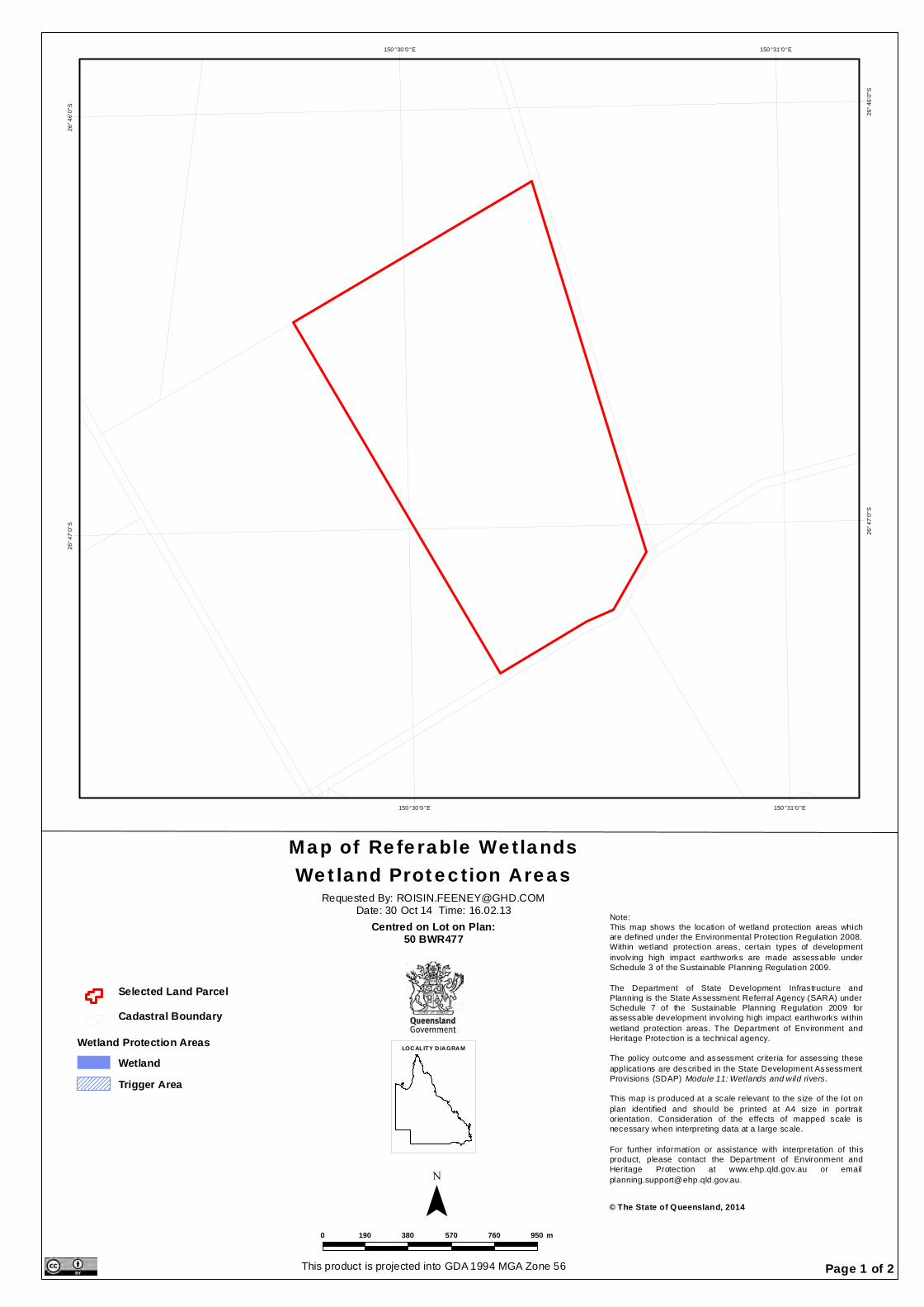
150 °31 '0 "E
150 °31 '0 "E
150 °30 '0 "E
150 °30 '0 "E
26°4
6'0"S
26°4
6'0"S
26°4
7'0"S
26°4
7'0"S
Map of Referable WetlandsWetland Protection Areas
¯ © The State of Queensland, 2014
Requested By: [email protected]: 30 Oct 14 Time: 16.02.13
Centred on Lot on Plan:50 BWR477
This product is projected into GDA 1994 MGA Zone 56
0 190 380 570 760 950 m
LOCALITY D IAGRAM
Selected Land ParcelCadastral Boundary
Wetland Protection AreasWetlandTrigger Area
Note:This map shows the location of wetland protection areas whichare defined under the Environmental Protection Regulation 2008.Within wetland protection areas, certain types of developmentinvolv ing high impact earthworks are made assessable underSchedule 3 of the Sustainable Planning Regulation 2009.
The Department of State Development Infrastructure andPlanning is the State Assessment Referral Agency (SARA) underSchedule 7 of the Sustainable Planning Regulation 2009 forassessable development involving high impact earthworks withinwetland protection areas. The Department of Environment andHeritage Protection is a technical agency.The policy outcome and assessment criteria for assessing theseapplications are described in the State Development AssessmentProvisions (SDAP) Module 11: Wetlands and wild rivers.
This map is produced at a scale relevant to the s ize of the lot onplan identified and should be printed at A4 size in portraitorientation. Consideration of the effects of mapped scale isnecessary when interpreting data at a large scale.
For further information or assistance with interpretation of thisproduct, please contact the Department of Environment andHeritage Protection at www.ehp.qld.gov.au or [email protected].
Page 1 of 2
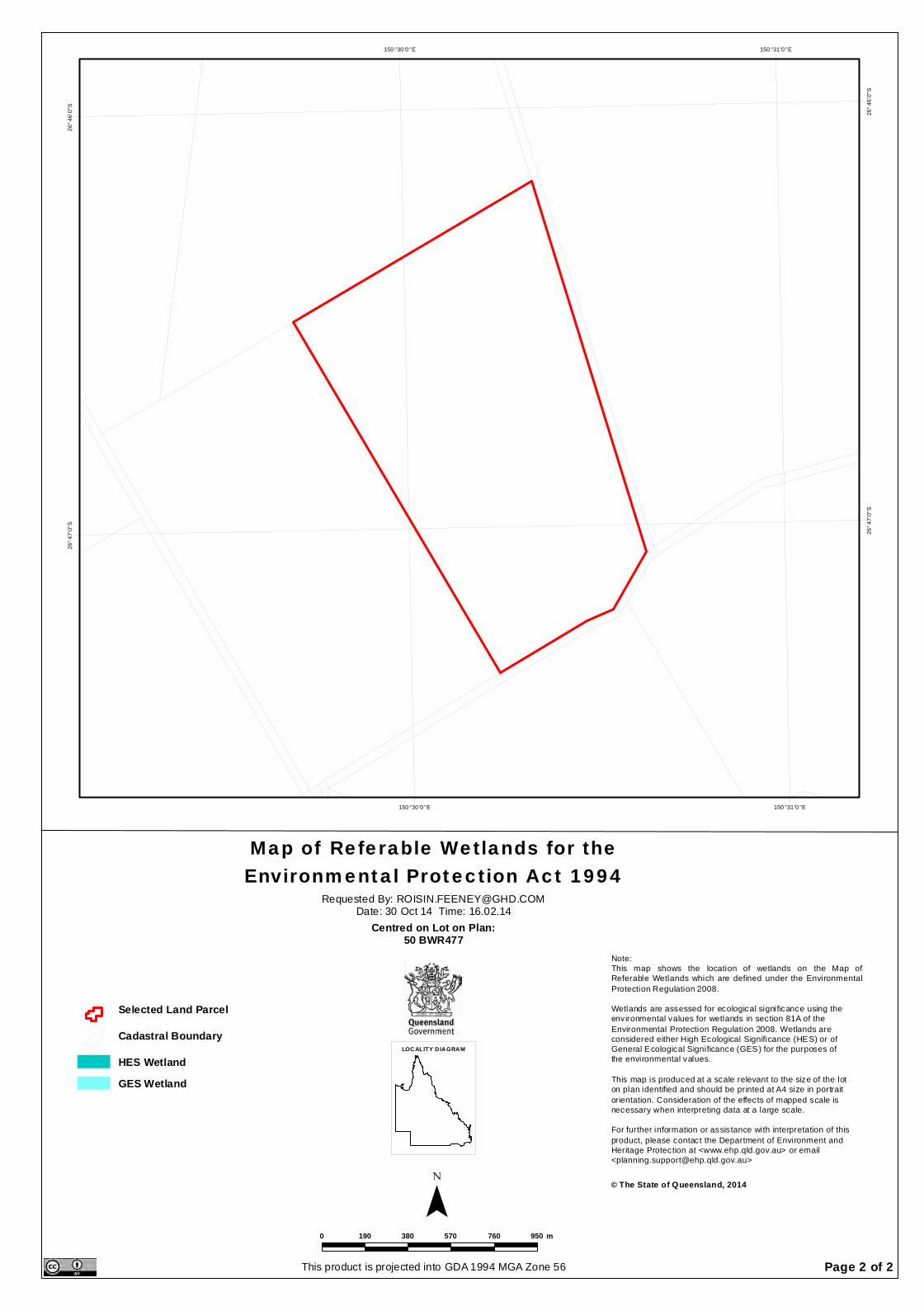
150 °31 '0 "E
150 °31 '0 "E
150 °30 '0 "E
150 °30 '0 "E
26°4
6'0"S
26°4
6'0"S
26°4
7'0"S
26°4
7'0"S
Map of Referable Wetlands for theEnvironmental Protection Act 1994
¯ © The State of Queensland, 2014
Requested By: [email protected]: 30 Oct 14 Time: 16.02.14
Centred on Lot on Plan:50 BWR477
This product is projected into GDA 1994 MGA Zone 56
0 190 380 570 760 950 m
LOCALITY D IAGRAM
Selected Land Parcel
Cadastral Boundary
HES WetlandGES Wetland
Note:This map shows the location of wetlands on the Map ofReferable Wetlands which are defined under the EnvironmentalProtection Regulation 2008.Wetlands are assessed for ecological significance using theenvironmental values for wetlands in section 81A of theEnvironmental Protection Regulation 2008. Wetlands areconsidered either High Ecological Significance (HES) or ofGeneral Ecological Significance (GES) for the purposes ofthe environmental values.
This map is produced at a scale relevant to the size of the loton plan identified and should be printed at A4 size in portraitorientation. Consideration of the effects of mapped scale isnecessary when interpreting data at a large scale.For further information or assistance with interpretation of thisproduct, please contact the Department of Environment andHeritage Protection at <www.ehp.qld.gov.au> or email<[email protected]>
Page 2 of 2
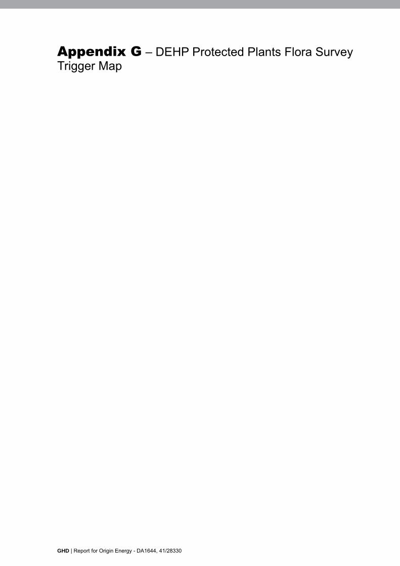
GHD | Report for Origin Energy - DA1644, 41/28330
Appendix G – DEHP Protected Plants Flora Survey Trigger Map
30/10/2014 15:22:02Lot: '50' Plan: 'BWR477'
GHD | Report for Origin Energy - DA1644, 41/28330
Appendix H – List of flora and fauna species identified in the Study Area
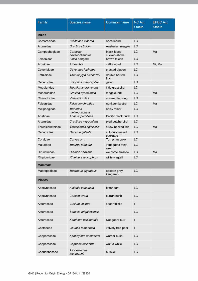
GHD | Report for Origin Energy - DA1644, 41/28330
Family Species name Common name NC Act Status
EPBC Act Status
Birds
Corcoracidae Struthidea cinerea apostlebird LC
Artamidae Cracticus tibicen Australian magpie LC
Campephagidae Coracina novaehollandiae
black-faced cuckoo-shrike
LC Ma
Falconidae Falco berigora brown falcon LC
Ardeidae Ardea ibis cattle egret LC Mi, Ma
Columbidae Ocyphaps lophotes crested pigeon LC
Estrildidae Taeniopygia bichenovii double-barred finch
LC
Cacatuidae Eolophus roseicapillus galah LC
Megaluridae Megalurus gramineus little grassbird LC
Monarchidae Grallina cyanoleuca magpie-lark LC Ma
Charadriidae Vanellus miles masked lapwing LC
Falconidae Falco cenchroides nankeen kestrel LC Ma
Meliphagidae Manorina melanocephala
noisy miner LC
Anatidae Anas superciliosa Pacific black duck LC
Artamidae Cracticus nigrogularis pied butcherbird LC
Threskiornithidae Threskiornis spinicollis straw-necked ibis LC Ma
Cacatuidae Cacatua galerita sulphur-crested cockatoo
LC
Corvidae Corvus orru Torresian crow LC
Maluridae Malurus lamberti variegated fairy-wren
LC
Hirundinidae Hirundo neoxena welcome swallow LC Ma
Rhipiduridae Rhipidura leucophrys willie wagtail LC
Mammals
Macropodidae Macropus giganteus eastern grey kangaroo
LC
Plants
Apocynaceae Alstonia constricta bitter bark LC
Apocynaceae Carissa ovata currantbush LC
Asteraceae Cirsium vulgare spear thistle I
Asteraceae Senecio brigalowensis LC
Asteraceae Xanthium occidentale Noogoora burr I
Cactaceae Opuntia tomentosa velvety tree pear I
Capparaceae Apophyllum anomalum warrior bush LC
Capparaceae Capparis lasiantha wait-a-while LC
Casuarinaceae Allocasuarina leuhmannii buloke LC
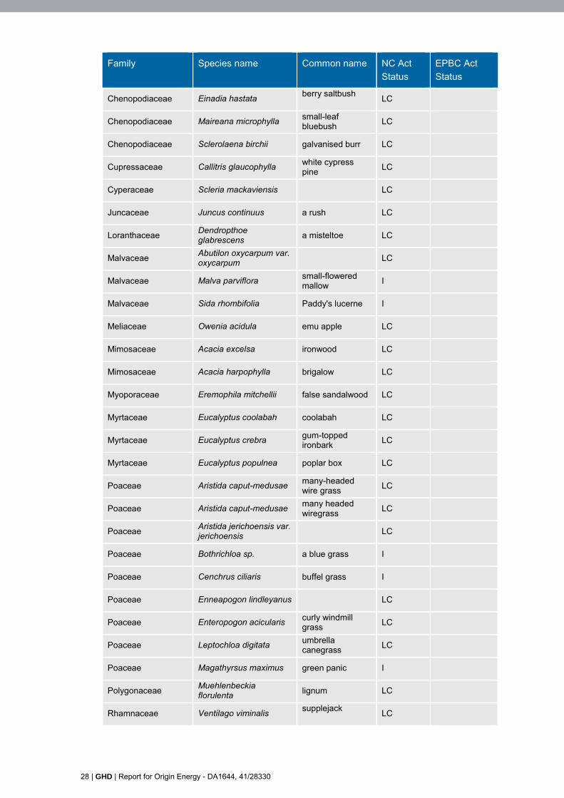
28 | GHD | Report for Origin Energy - DA1644, 41/28330
Family Species name Common name NC Act Status
EPBC Act Status
Chenopodiaceae Einadia hastata berry saltbush LC
Chenopodiaceae Maireana microphylla small-leaf bluebush LC
Chenopodiaceae Sclerolaena birchii galvanised burr LC
Cupressaceae Callitris glaucophylla white cypress pine LC
Cyperaceae Scleria mackaviensis LC
Juncaceae Juncus continuus a rush LC
Loranthaceae Dendropthoe glabrescens a misteltoe LC
Malvaceae Abutilon oxycarpum var. oxycarpum LC
Malvaceae Malva parviflora small-flowered mallow I
Malvaceae Sida rhombifolia Paddy's lucerne I
Meliaceae Owenia acidula emu apple LC
Mimosaceae Acacia excelsa ironwood LC
Mimosaceae Acacia harpophylla brigalow LC
Myoporaceae Eremophila mitchellii false sandalwood LC
Myrtaceae Eucalyptus coolabah coolabah LC
Myrtaceae Eucalyptus crebra gum-topped ironbark LC
Myrtaceae Eucalyptus populnea poplar box LC
Poaceae Aristida caput-medusae many-headed wire grass LC
Poaceae Aristida caput-medusae many headed wiregrass LC
Poaceae Aristida jerichoensis var. jerichoensis
LC
Poaceae Bothrichloa sp. a blue grass I
Poaceae Cenchrus ciliaris buffel grass I
Poaceae Enneapogon lindleyanus LC
Poaceae Enteropogon acicularis curly windmill grass LC
Poaceae Leptochloa digitata umbrella canegrass LC
Poaceae Magathyrsus maximus green panic I
Polygonaceae Muehlenbeckia florulenta lignum LC
Rhamnaceae Ventilago viminalis supplejack LC
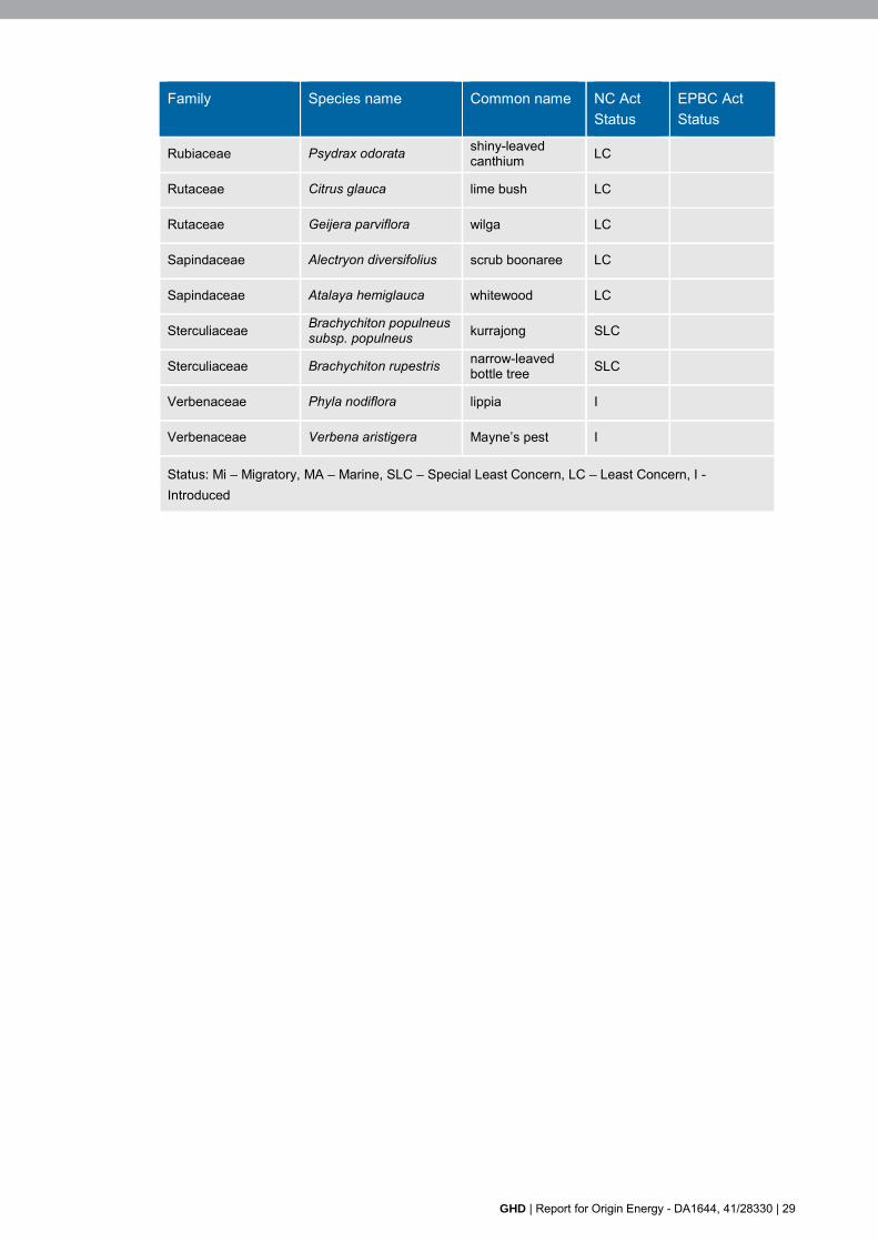
GHD | Report for Origin Energy - DA1644, 41/28330 | 29
Family Species name Common name NC Act Status
EPBC Act Status
Rubiaceae Psydrax odorata shiny-leaved canthium LC
Rutaceae Citrus glauca lime bush LC
Rutaceae Geijera parviflora wilga LC
Sapindaceae Alectryon diversifolius scrub boonaree LC
Sapindaceae Atalaya hemiglauca whitewood LC
Sterculiaceae Brachychiton populneus subsp. populneus kurrajong SLC
Sterculiaceae Brachychiton rupestris narrow-leaved bottle tree SLC
Verbenaceae Phyla nodiflora lippia I
Verbenaceae Verbena aristigera Mayne’s pest I
Status: Mi – Migratory, MA – Marine, SLC – Special Least Concern, LC – Least Concern, I - Introduced

GHD | Report for Origin Energy - DA1644, 41/28330 | 31
Appendix I – Ground-truthed Regional Ecosystems and Regrowth

145 Ann Street Brisbane QLD 4000 Australia T 61 7 3316 3000 F 61 7 3316 3333 E [email protected] W www.ghd.com
11.5.1100
SHERIFFS ROAD
GREENSWAMP ROAD
LEBSANFTS ROAD
50BWR477
51BWR126
249,000
249,000
249,500
249,500
250,000
250,000
250,500
250,500
251,000
251,000
251,500
251,500
252,000
252,000
252,500
252,500
253,000
253,000
253,500
253,500
7,034,
000
7,034,
000
7,034,
500
7,034,
500
7,035,
000
7,035,
000
7,035,
500
7,035,
500
7,036,
000
7,036,
000
7,036,
500
7,036,
500
G:\41\28330\GIS\Maps\MXD\41_28330_019_Pascoe_Sur_rev_0.mxd© 2015. Whilst every care has been taken to prepare this map, GHD and DNRM make no representations or warranties about its accuracy, reliability, completeness or suitability for any particular purpose and cannot accept liability and responsibility of any kind (whether in contract, tort or otherwise) for any expenses, losses, damages and/or costs (including indirect or consequential damage) which are or may be incurred by any party as a result of the map being inaccurate, incomplete or unsuitable in any way and for any reason.
LEGEND0 250 500125
MetresMap Projection: Transverse Mercator
Horizontal Datum: GDA 1994Grid: GDA 1994 MGA Zone 56
Origin EnergyEcological Assessment Report
Figure 4
Job NumberRevision 0
41-28330
30 Jan 2015Field Verified RegionalEcosystem Mapping & Regrowth Mappingo Date
Data source: DNRM: Baseline Roads, Petroleum Lease, 2014; Origin Energy: Imagery, Cadastre 2014; GHD: Field Verified Regional Ecosystem, Survey Area, 2014. Created by: RB
Paper Size A3Local RoadLot Boundaries Within Study AreaLot Boundaries Outside Study Area
Survey AreaPetroleum Lease
Remnant VegetationOf Concern RE
Based on or contains data provided by the State of QLD (DNRM) [2014]. In consideration of the Statepermitting use of this data you acknowledge and agree that the State gives no warranty in relationto the data (including accuracy, reliability, completeness, currency or suitability) and accepts no liability(including without limitation, liability in negligence) for any loss, damage or costs (including conse-quential damage) relating to any use of the data. Data must not be used for marketing or be used inbreach of the privacy laws.
32 | GHD | Report for Origin Energy - DA1644, 41/28330
Appendix J – Ground-truthed pest flora and fauna
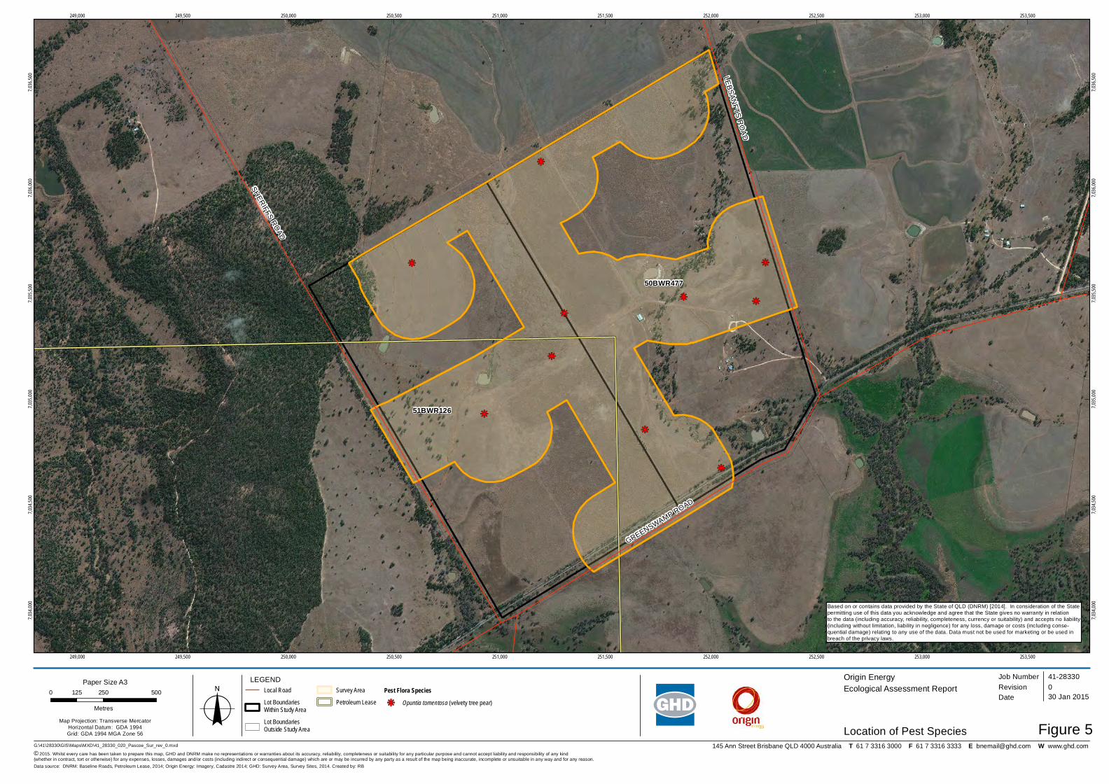
145 Ann Street Brisbane QLD 4000 Australia T 61 7 3316 3000 F 61 7 3316 3333 E [email protected] W www.ghd.com
kj
kj
kj
kj
kj
kj
kj
kj kj
kj
SHERIFFS ROAD
GREENSWAMP ROAD
LEBSANFTS ROAD
50BWR477
51BWR126
249,000
249,000
249,500
249,500
250,000
250,000
250,500
250,500
251,000
251,000
251,500
251,500
252,000
252,000
252,500
252,500
253,000
253,000
253,500
253,500
7,034,
000
7,034,
000
7,034,
500
7,034,
500
7,035,
000
7,035,
000
7,035,
500
7,035,
500
7,036,
000
7,036,
000
7,036,
500
7,036,
500
G:\41\28330\GIS\Maps\MXD\41_28330_020_Pascoe_Sur_rev_0.mxd© 2015. Whilst every care has been taken to prepare this map, GHD and DNRM make no representations or warranties about its accuracy, reliability, completeness or suitability for any particular purpose and cannot accept liability and responsibility of any kind (whether in contract, tort or otherwise) for any expenses, losses, damages and/or costs (including indirect or consequential damage) which are or may be incurred by any party as a result of the map being inaccurate, incomplete or unsuitable in any way and for any reason.
LEGEND0 250 500125
MetresMap Projection: Transverse Mercator
Horizontal Datum: GDA 1994Grid: GDA 1994 MGA Zone 56
Origin EnergyEcological Assessment Report
Figure 5
Job NumberRevision 0
41-28330
30 Jan 2015
Location of Pest Specieso Date
Data source: DNRM: Baseline Roads, Petroleum Lease, 2014; Origin Energy: Imagery, Cadastre 2014; GHD: Survey Area, Survey Sites, 2014. Created by: RB
Paper Size A3Local RoadLot Boundaries Within Study AreaLot Boundaries Outside Study Area
Survey AreaPetroleum Lease
Pest Flora Specieskj Opuntia tomentosa (velvety tree pear)
Based on or contains data provided by the State of QLD (DNRM) [2014]. In consideration of the Statepermitting use of this data you acknowledge and agree that the State gives no warranty in relationto the data (including accuracy, reliability, completeness, currency or suitability) and accepts no liability(including without limitation, liability in negligence) for any loss, damage or costs (including conse-quential damage) relating to any use of the data. Data must not be used for marketing or be used inbreach of the privacy laws.
GHD | Report for Origin Energy - DA1644, 41/28330 | 33
Appendix K – Ground-truthed conservation significant species

145 Ann Street Brisbane QLD 4000 Australia T 61 7 3316 3000 F 61 7 3316 3333 E [email protected] W www.ghd.com
SHERIFFS ROAD
GREENSWAMP ROAD
LEBSANFTS ROAD
50BWR477
51BWR126
249,000
249,000
249,500
249,500
250,000
250,000
250,500
250,500
251,000
251,000
251,500
251,500
252,000
252,000
252,500
252,500
253,000
253,000
253,500
253,500
7,034,
000
7,034,
000
7,034,
500
7,034,
500
7,035,
000
7,035,
000
7,035,
500
7,035,
500
7,036,
000
7,036,
000
7,036,
500
7,036,
500
G:\41\28330\GIS\Maps\MXD\41_28330_031_Pascoe_Sur_rev_0.mxd© 2015. Whilst every care has been taken to prepare this map, GHD and DNRM make no representations or warranties about its accuracy, reliability, completeness or suitability for any particular purpose and cannot accept liability and responsibility of any kind (whether in contract, tort or otherwise) for any expenses, losses, damages and/or costs (including indirect or consequential damage) which are or may be incurred by any party as a result of the map being inaccurate, incomplete or unsuitable in any way and for any reason.
LEGEND0 250 500125
MetresMap Projection: Transverse Mercator
Horizontal Datum: GDA 1994Grid: GDA 1994 MGA Zone 56
Origin EnergyEcological Assessment Report
Figure 6a
Job NumberRevision 0
41-28330
30 Jan 2015
Locations of EPBC Act threat-listed specieso Date
Data source: DNRM: Baseline Roads, Petroleum Lease, 2014; Origin Energy: Imagery, Cadastre 2014; GHD: Survey Area, Survey Sites, 2014. Created by: RB
Paper Size A3Local RoadLot Boundaries Within Study AreaLot Boundaries Outside Study Area
Survey AreaPetroleum Lease
Marine SpeciesCattle EgretStraw-Necked Ibis
Nankeen KestrelWelcome Swallow
Based on or contains data provided by the State of QLD (DNRM) [2014]. In consideration of the Statepermitting use of this data you acknowledge and agree that the State gives no warranty in relationto the data (including accuracy, reliability, completeness, currency or suitability) and accepts no liability(including without limitation, liability in negligence) for any loss, damage or costs (including conse-quential damage) relating to any use of the data. Data must not be used for marketing or be used inbreach of the privacy laws.
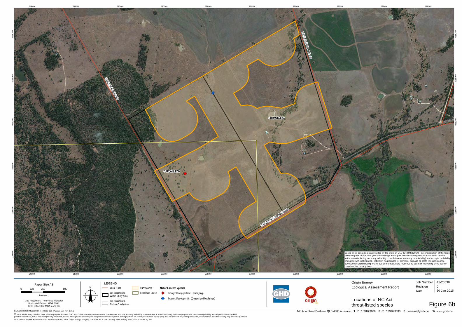
145 Ann Street Brisbane QLD 4000 Australia T 61 7 3316 3000 F 61 7 3316 3333 E [email protected] W www.ghd.com
kj
kj
SHERIFFS ROAD
GREENSWAMP ROAD
LEBSANFTS ROAD
50BWR477
51BWR126
249,000
249,000
249,500
249,500
250,000
250,000
250,500
250,500
251,000
251,000
251,500
251,500
252,000
252,000
252,500
252,500
253,000
253,000
253,500
253,500
7,034,
000
7,034,
000
7,034,
500
7,034,
500
7,035,
000
7,035,
000
7,035,
500
7,035,
500
7,036,
000
7,036,
000
7,036,
500
7,036,
500
G:\41\28330\GIS\Maps\MXD\41_28330_021_Pascoe_Sur_rev_0.mxd© 2015. Whilst every care has been taken to prepare this map, GHD and DNRM make no representations or warranties about its accuracy, reliability, completeness or suitability for any particular purpose and cannot accept liability and responsibility of any kind (whether in contract, tort or otherwise) for any expenses, losses, damages and/or costs (including indirect or consequential damage) which are or may be incurred by any party as a result of the map being inaccurate, incomplete or unsuitable in any way and for any reason.
LEGEND0 250 500125
MetresMap Projection: Transverse Mercator
Horizontal Datum: GDA 1994Grid: GDA 1994 MGA Zone 56
Origin EnergyEcological Assessment Report
Figure 6b
Job NumberRevision 0
41-28330
30 Jan 2015
Locations of NC Actthreat-listed specieso Date
Data source: DNRM: Baseline Roads, Petroleum Lease, 2014; Origin Energy: Imagery, Cadastre 2014; GHD: Survey Area, Survey Sites, 2014. Created by: RB
Paper Size A3Local RoadLot Boundaries Within Study AreaLot Boundaries Outside Study Area
Survey AreaPetroleum Lease
Not of Concern Specieskj Brachychiton populneus (kurrajong)kj Brachychiton rupestris (Queensland bottle tree)
Based on or contains data provided by the State of QLD (DNRM) [2014]. In consideration of the Statepermitting use of this data you acknowledge and agree that the State gives no warranty in relationto the data (including accuracy, reliability, completeness, currency or suitability) and accepts no liability(including without limitation, liability in negligence) for any loss, damage or costs (including conse-quential damage) relating to any use of the data. Data must not be used for marketing or be used inbreach of the privacy laws.

Appendix L – Ground-truthed watercourses and waterways
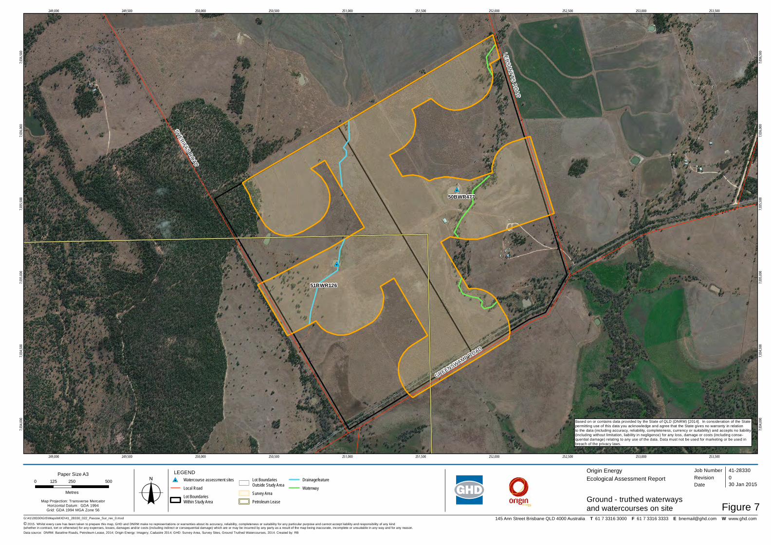
145 Ann Street Brisbane QLD 4000 Australia T 61 7 3316 3000 F 61 7 3316 3333 E [email protected] W www.ghd.com
#0
#0
SHERIFFS ROAD
GREENSWAMP ROAD
LEBSANFTS ROAD
50BWR477
51BWR126
249,000
249,000
249,500
249,500
250,000
250,000
250,500
250,500
251,000
251,000
251,500
251,500
252,000
252,000
252,500
252,500
253,000
253,000
253,500
253,500
7,034,
000
7,034,
000
7,034,
500
7,034,
500
7,035,
000
7,035,
000
7,035,
500
7,035,
500
7,036,
000
7,036,
000
7,036,
500
7,036,
500
G:\41\28330\GIS\Maps\MXD\41_28330_022_Pascoe_Sur_rev_0.mxd© 2015. Whilst every care has been taken to prepare this map, GHD and DNRM make no representations or warranties about its accuracy, reliability, completeness or suitability for any particular purpose and cannot accept liability and responsibility of any kind (whether in contract, tort or otherwise) for any expenses, losses, damages and/or costs (including indirect or consequential damage) which are or may be incurred by any party as a result of the map being inaccurate, incomplete or unsuitable in any way and for any reason.
LEGEND0 250 500125
MetresMap Projection: Transverse Mercator
Horizontal Datum: GDA 1994Grid: GDA 1994 MGA Zone 56
Origin EnergyEcological Assessment Report
Figure 7
Job NumberRevision 0
41-28330
30 Jan 2015
Ground - truthed waterwaysand watercourses on siteo Date
Data source: DNRM: Baseline Roads, Petroleum Lease, 2014; Origin Energy: Imagery, Cadastre 2014; GHD: Survey Area, Survey Sites, Ground Truthed Watercourses, 2014. Created by: RB
Paper Size A3#0 Watercourse assessment sites
Local RoadLot Boundaries Within Study Area
Lot Boundaries Outside Study AreaSurvey AreaPetroleum Lease
DrainagefeatureWaterway
Based on or contains data provided by the State of QLD (DNRM) [2014]. In consideration of the Statepermitting use of this data you acknowledge and agree that the State gives no warranty in relationto the data (including accuracy, reliability, completeness, currency or suitability) and accepts no liability(including without limitation, liability in negligence) for any loss, damage or costs (including conse-quential damage) relating to any use of the data. Data must not be used for marketing or be used inbreach of the privacy laws.

GHD 145 Ann Street Brisbane QLD 4000 GPO Box 668 Brisbane QLD 4001 T: (07) 3316 3000 F: (07) 3316 3333 E: [email protected] © GHD 2014 This document is and shall remain the property of GHD. The document may only be used for the purpose for which it was commissioned and in accordance with the Terms of Engagement for the commission. Unauthorised use of this document in any form whatsoever is prohibited. G:\41\28330\WP\463524.docx Document Status
Rev No.
Author Reviewer Approved for Issue Name Signature Name Signature Date
A S. Wilkins N. Willis
M. Ward Draft K. Neil Draft 05/12/2014 0 S. Wilkins
N. Willis M. Ward
K. Neil
30/01/2015

www.ghd.com