Embed Size (px)
Citation preview
UNIVERSITY ~ ~~ - - - - ~~ OF NEVADA BULLETIN ~ ~ ~
p~
VOI,. XXV ACGUST 1,1931 No. 5 -~ ~ - - - - ~
- - - ~-~p
ORE DEPOSITS OF THE GOLD CIRCLE MINING DISTRICT,
ELK0 COUNTY, NEVADA
By EDWARD H. ROTT, Jn. Arsirtant Geologist. Consolidated Coppermines
Corporation. Kimberly, Nevada
PUULTBHEII QUARTERLY
BY TH6
TJNIVERSITY O F NEVADA REXO. KEVADA

STATE PRINTING OFFICE . . JOE FARNSWORTH. SUPERINTENDENT
CARSON CITY. NEVADA 1 0 3 1
Foreword.
TABLE OF CONTENTS
Introduetion-
Geology-
3Iegascopie Charact

LIST O F ILLUSTRATIONS
I'AGb
I'LATE I-Geologic Map. East Central Portion, Gold Circle District, Nevada ....................... facing page 16
PLATE 11-11, Banding in Vein 'illing. Elko Prince Vein. B. Banding in Vein Filling. 3Iissing Linkvein.. 20
PLATE 111-Siliceous Hox~irurk After Calcite in Vein Filling. Grant-Jacksun TTei 21
PLATE I\r-Rec~mented Grecciated ite as Vcin Filling. Grant-Jackson Vei 22
PLATE V-Recemented Breceiated Siliceous Vein Filling. Colo- rado Grande Faul 22
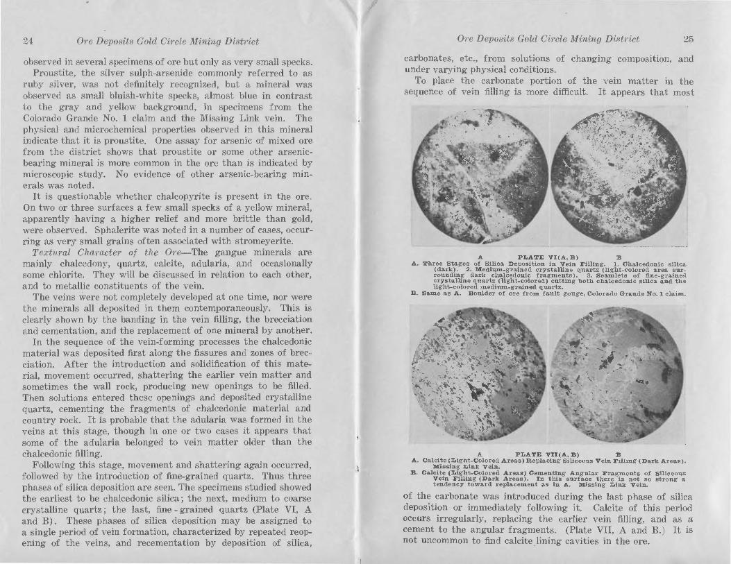
PLATE VI-(A, B) Three Stages of Silica Deposition in Vein -. .
............ B ~ l l ~ n g ........................................................... 25 PLATE VII-A. Calcite Replacing Siliceous Gangue. Missing
Link Vein. B. Calcite Cementing Brecciatcd Siliceous Gangue. Missing Link vein..^^^^^^.^^^^. 26
P L A ~ ~ E VIII-Pyrite Replacing Earlier Siliceous Gangue. Missing L i n k V c i n . . ............................................................. 27
PLATE IX-"Petal" Worm Calcit,e Lining Cavity in Siliceous .................. Gangue. Missing Link Vein.............. 27
FIGERE 1-Index Nap of Nevada Showing the Locatioi~ of Gold Circle District. (Revised from U. S. C. S. Bull. 408 8
FIGURE %Plan of ...................... Intersection with Premineral Fault 16
FIGURE &Section Through l\lajur Ore Shoot in Grant-Jackson Vein with the Xechani as Which Aided in I ts Formation, Illustrated 17
FIGURE 4--Graphical Representation o ............ tion of the Metallic Minerals in the Veins 26
FOREWORD
This bulletin is a thesis, with some additions thereto, submitted by Mr. Rott f o r t h e degree of Master of Arts a t t h e University of California.
The policy of the Bureau of Mines is to publish pertinent information regarding Nevada mining districts. This paper deals with a district which has not heretofore received any comprehensive petrographic study of its ores o r country rocks, and is therefore t h e first scientific geologic treatise in detail on the district.
JOHN A. FULTON, Director.
THE ORE DEPOSITS OF THE GOLD CIRCLE MINING DISTRICT, NEVADA
By Edward H. Rott, Jr.
INTRODUCTION
FIELD AND LABORATORY WORX
This paper is based on work done in the Gold Circle mining district during the summer of 1927 and during brief visits to the district in June, 1928, and April, 1929. The field work was supplemented by laboratory study of the specimens collected in the district a t the University of California during the fall and spring semesters of 1927 and 1928, and by a brief review of the material in the geologic laboratory of Consolidated Coppermines Corporation a t Kimberly, Nevada, in the fall of 1930.
A considerable part of the district was studied in detail, and a geologic map prepared (Plate I). Detailed underground geo- logic mapping was done on the 300 level of the Elko Prince and June Bell veins, in the Grant and Jackson mine, in the Reco tun- nel, and in the Rex tunnel. Other workings in the district were examined for the general character of the veins, wall rocks, asso- ciated intrusives, and faulting.
ACKNOmEDCIMENTS
The author is sincerely grateful to the staff of the Gold Circle Consolidated Mines, especially to Senator Noble H. Getchell, gen- eral manager, who made this work possible. Dr. George D. Lou- derback and Dr. Carlton D. Hulin have given invaluable advice. suggestions qnd criticism during the progress of this work a t the University of California.
LOCATION OF THE DISTRICT
Gold Circle, also known as Midas District, is in the northcentral part of Nevada just east of the west boundary of Elko County. I t lies about forty-five miles north of Battle Mountain, and fifty miles northeast of Goleonda, towns on the Southern Pacific Rail- road (Figure 1). Tuscarora, a thriving camp from 1872 until 1890, lies thirty-five miles east. Red House, a station on the Western Pacific Railroad, is about thirty-five miles southwest. Stage lines are operated on alternate days, except Sundays, from Midas to Golconda and Battle Mountain.

*
Ore Deposits Gold Circle ,ni?zing District
PIQUEE 1 Index map of Xevada Showing the Location of Gola Circle Dlstrlct.
(Bevised from u. 8. G.S. snlletln 408.)
1 Ore Deposits Gold Circle Mining District 9
TOPOGRAPHY
The district lies in the hilly country along the southeast slope of the Owyhee Bluffs, between the bluffs and Squaw Valley. The area gradually increases in elevation from south to north, merging with the bluffs to the north and northeast. In the area covered by this work the maximum relief is about 1,000 feet. In the immediate vicinity of Midas the bluffs are sharply separated from the hilly country, and swing to the west, south of town, away from the hill area.
HISTORY O F THE DISTRICT
Gold was discovered in the summer of 1907 and by March, 1908, the camp was booming. The first excitement soon subsided and the town, which increased in population to over 1,500 people dur- ing the boom, shrunk to a settlement of 250 by September.
A number of companies were organized to operate the mines of the district, and in all six or more mills, ranging in capacity from twenty-five to seventy-five tons per day, were built and oper- ated a t different times during the life of the camp. The operations of the Elko Prince Mining Company and the Gold Circle Consoli- dated Mines were the most extensive in the district.
The Elko Prince mine was located in 1907 and taken over by the Elko Prince Mining Company in 1908, By agreement with the Dorr Company, a fifty-ton cyanide mill was erected a t t h t mine in 1915 and operated until 1922, when the mill burned. Soon after the mill burned the company ceased operation. By 1926 this and the most promising holdings in the district had been acquired by the Gold Circle Consolidated Mines. Mining operations were begun and a seventy-five ton cyanide mill con- structed by the Gold Circle Consolidated Mines. Treatment of ore started in the spring of 1927 and operations continued until the fall of 1929. The principal production during this period came from the Grant-Jackson vein above the 225 level, and from the Missing Link vein. From the latter part of 1928 until the mill was shut down in the fall of 1929, some production came from the Elko Prince vein above the 600 level, principally from the 450 level, and from the 300 level on the June Bell vein.
Through reorganization, the Gold Circle Consolidated Mines absorbed the Betty O'Neal Mines in Nevada, and its holding8 - in Arizona. The company has started to dewater the Elko Prince shaft to the 900 foot' level, and plan to sink the shaft to the 1,200 foot level. Development on the other holdings will follow. Some leasers are working in the district, and through

10 Ore Deposits Gold Circle Mining Distvict
agreement with the Gold Circle Consolidated Mines their ore is treated a t the company's mill.
From 1908 to 1929 the gross production of the district was slightly over $3,000,000. Two-thirds of this amount was pro- duced in the years 1916 to 1922, during which time the Elko Prince mill was in operation, and one-fifth of the total produc- tion came from the Gold Circle Consolidated Mines during the period from 1927 to 1929.
GEOLOGY aENERAL GEOLOaIC FEATUBES
The terrane examined was one of extensive Tertiary volcanic activity. I t includes flows of rhyolite, andesite, and basalt, with minor areas of rhyolite tuff, rhyolite breccia and less important exposures of olivine diabase. To facilitate geologic mapping these formations have been divided according to lithologic differences rather than major structural breaks. The three major divisions in the order of their time sequence are: pre-andesite rhyolite, andesite (principally andesite flows, some basalt, and minor occur- rences of olivine diabase), and post-andesite rhyolite. Acid and basic dikes locally cut horizons as young as the basal portion oi the post-andesite rhyolite.
Hydrothermal alteration has affected most of these rocks to such a degree that fresh specimens are rarely met within the min- eralized area. The alteration is greater near the veins, diminish- ing proportionately with the distance from them.
Faulting changed the original position of the flows, and aided in opening channels along which hydrothermal solutioqs passed. These solutions deposited silica, calcite, and the metallic minerals which comprise the ore-bearing veins. During this process the country rock was generally bleached to a white, chalky formation which stands in noticeable contrast to the less altered rocks far- ther away from the zone of intense mineralization. In places the more basic rocks were acted upon to such an extent by the hydro- thermal solutions that they now appear as white, friable masses of calcite and silica.
Thin sections of the principal rock types were prepared and studied microscopically. In some cases the altered condition of the rocks made i t difficult to determine their true character.
PRE-ANDESITE SWOLITE The pre-andesite ryholite, known as the Elko Prince rhyolite,
after the area in which it was differentiated from the June Bell
Ore Deposit8 Gold Circle Mining District 11
rhyolite and post-andesite rhyolites, occurs in both the east and west walls of the Elko Prince vein a t the surface, and in the east wall of the vein on the 300 level. This rhyolite is moderately hard, and white to light gray in color. I t is compact with a few dull phenocrysts and shows some small vesicules. The ground- mass is devitrified glassy material. The rock contains phenocrysts of alkali and soda-lime feldspar, quartz, and a notable amount of zircon in small crystals. What appears to be tuffaceous material occurs occasionally in the formation.
The Elko Prince rhyolite is in contact with the andesite under- ground and a t the surface. The underground contact indicates that this series of flows is conformably overlain by the andesite flows. This rhyolite has not been differentiated from the post- andesite rhyolites and the June Bell rhyolite in the major portion of the district.
ANDESITE
Closely following the Elko Prince rhyolite, andesite with some intercalated basalt and diabase flows was poured forth on the surface of the rhyolite. The parts of the contact that were exposed in underground workings gave no indications of an ero- sion interval between the rhyolite and the andesite. The andesite and associated flows occur in the southeast, southwest, and north- ern portion of the area mapped, with some irregular masses and dikes occurring within the rhyolite area.
The andesite varies considerably in appearance, but in a gen- eralized description i t may be designated as a greenish-brown, hypocrystalline, porphyritic rock, with feldspar and pyroxene phenocrysts in a matrix of undifferentiated constituents. Under the microscope the feldspar was seen to be acid andesine, and the pyroxene to be augite. The feldspars are partly altered to calcite and sericite, and the pyroxene to calcite and chlorite. In general, the rock is fine-grained, with lath shaped phenocrysts of acid andesine and augite in an altered groundmass of glass, chlo- ritic material, and calcite.
Another specimen contained phenocrysts of basic andesine and augite in a groundmass composed principally of brown glass, with some feldspar laths (about acid andesine), minute prisms of apatite, relatively large crystals of magnetite and intensely altered material composed of serpentine, calcite, and iron oxide. Secondary silica and remnants of biotite occur, also amygdules of calcite and chalcedonic silica.
The diabase is a black, holocrystalline, medium coarse-grained

12 Ore Deposits Gold Circle Mining District
roek composed of soda-lime feldspar, pyroxene, and olivine, with some magnetite. Microscopic determination showed the original minerals to be basic andesine, augite, olivine, magnetite, apatite. and brown biotite. The olivine is almost completely altered to serpentine and antigorite, with associated calcite and iron oxide. Kelyphitic structure is well developed about the olivine. Pigeon- ite, a pyroxene of small, variable axial angle, was noted in one specimen. 2V for the mineral in this specimen measured less than 16".
The basalt is a black, hypocrystalline, medium-grained porphy- ritic rock, with phenocrysts of labradorite, augite, and olivine, in a groundmass of very small laths of feldspar, grains of augite and greenish to brownish glass, with such alternation products as chlorite, calcite, and iron oxide. The olivine is largely altered to serpentine.
Some of the basic rocks are intensely altered to a white or yellowish white roek, with few partly preserved mineral particles. Under the microscope this rock is seen to consist of serpentine, calcite, quartz, amorphous silica, probably some kaolin, a few mag- netite grains, and an occasional partly altered feldspar. Appar- ently the major portion of the femic minerals has been altered and the heavier constituents removed. Phases of more extreme alter- ation appear to contain chiefly amorphous silica, serpentine, and calcite in a form soft, friable, and of low specific gravity. This can be traced through gradations into the relatively fresh, black basalt.
POST-ANDESITE RHYOLITE FLOWS AND TUFF
The post-andesite rocks consist chiefly of rhyolite flows and tuffs. Some of these were examined microscopically. A typical example of the flow rocks contained phenocrysts of acid oligo- clase and orthoclase. Some quartz occurs in the devitrified glassy groundmass. In some specimens examined microscopically the mineralogic character of the rock was that of a trachyte rather than a rhyolite. I t is sometimes impossible. to determine whether one is dealing with post-andesite or pre-andesite flows. This can only be decided by detailed mapping of the formations and petro- graphic study of a number of specimens.
The tuffs vary notably in character. Some are white, differing little from the flows in general appearance, but showing shards and fragments of feldspar in a pasty matrix of minute mineral and glass fragments. Devitrification of the glass is common. Another facies is composed of poorly consolidated, soft, white,
Ore Deposits Gold Circle Mining District 13
pasty material with greenish spots. The distribution of this material indicates that i t is probably the latest facies of post- andesite eruption.
Amygdaloidal post-andesite rhyolite occurs on the Colorado Grande No. 3 claim on Queen Peak, and on the ridge south. Some chalcedonic amygdaloids, three-fourths to one inch in diameter, were found south of Queen Peak.
On the surface, the June Bell rhyolite is limited to a small area on the June Bell claim; underground i t is more extensive. It occurs in the west wall of the Elko Prince vein on the 300 level and in both the footwall and hanging wall of the June Bell vein. This rhyolite is a very hard, dense type, showing perfect flow struc- ture. Microscopic examination revealed phenocrysts of oligoclase, small apatite prisms and, rarely, minute prisms of zircon or tita- nite, accompanied by occasional spherulites, in a dense, devitrified, glassy and micro-crystalline groundmass. The quartz occurs chiefly in micrographic intergrowth with feldspar, and as small, irregular patches that are apparently secondary silica.
The flow structure in the June Bell rhyolite has a consistent strike and a steep dip. On the surface it is in distinct discordance with the Elko Prince flows. The data obtainable on the contact between the two formations were insufficient todetermine whether the June Bell rhyolite was intrusive into the Elko Prince rhyolite, or the Elko Prince flows were resting on an erosion surface. Underground, there was not an opportunity to observe this body of rhyolite in other than fault contact to other formations. From the data available this rhyolite cannot be designated as either extrusive or intrusive. If extrusive, i t is a uniform series of flows which have been either intensely folded, or steeply tilted by fault- ing, and is older than the Elko Prince rhyolite, separated from it by a structural and erosional break. If intrusive, it is younger than the Elko Prince rhyolite and probably associated with the first series of rhyolite flows in post-andesite time.
DIKES Both acid and basic dikes occur in the district. They are more
numerous than is shown on the map. The dike rocks studied microscopically proved to be either rhyolitic or andesitic.
Adjacent to the Missing Link vein is a dike which differs in character from those generally observed in the area. This dike appears to be a typical lamprophyre. I t is black in color, very dense, and in general altered and softened. The dike is younger
14 Ore Deposits Gold Circle Mining District
than the vein, which may be found on either side of it, cutting it, or splitting i t to form a sheeted zone within it. The dike ranges in width from one to three feet.
STRUCTURE The Elko Prince rhyolite is the only formation in the district
known to be definitely pre-andesite in age. Exposures of the con- tact between the two formations in the underground workings show the andesite lying conformably upon a series of flows of Elko Prince rhyolite. Following the andesite, rhyolite flows and tuffs were poured forth. The earlier flows of this period lie conform- ably upon the andesite, and are separated from a later one by an unconformity, marked by both erosional and structural features. The earlier lavas consist of rhyolite flows and well-consolidated tuffs; the later ones are poorly consolidated tuffs.
During the period of suspended volcanic activity, marked by the unconformity, erosion continued, accompanied by pronounced faulting.
The fissures, sheeted zones, and shattered zones were formed a t this time and later became the channels in which the mineraliz- ing and metallizing solutions moved, depositing their load and hydrothermally altering the wall rock. Some of these are zones of fracturing, suitable locations for solutions t o circulate and deposit their contents; others are pronounced faults.
Following this period of disturbance, volcanic activity was renewed, and the country buried by the late post-andesite tuffs to a depth of several hundred feet. Erosion followed, carving out the present physiographic expression of the region. Neither veins nor other evidence of mineralization have been found asso- ciated with these tuffs, and the faulting and tilting affecting them is of minor importance.
The country is divided into fault blocks, and within the different blocks the attitudes of the formations vary from practically horizontal to nearly 60° dip. Faulting started in pre-mineral times, when i t apparently reached its maximum intensity. It continued with less intensity during the period of mineralization, and there is some minor post-mineral faulting.
The major fault zones of the district, and the faulting which developed most of the vein openings, belong to two periods of pre-mineral faulting. Some of the fissures in which veins have fomned were developed before the major faults, and have been offset by them prior to the mineralization. In these cases the ore
Ore Deposits Gold Circle Mining District 16
may be found in both segments of the vein and along the section of the fault between the separated vein segments.
Post-mineral faulting has not been found to have produced more than a few feet of displacement, and in general no evi- dence has been found to indicate that great importance should be attached to post-mineral faults. In one case there is evidence of post-mineral faulting of more than average intensity. This is a t the southeast end of the Gold Crown vein where it is cut by a fault a t a very acute angle. The character of the movement, and the extent of the displacement has not been determined. This movement was evident from the crushing and rounding of frag- ments of vein matter, which were found in the gouge along the fault, 50 or 60 feet from the intersection.
In general, the veins of the district strike N 30" t o 60" W and vary from 65O E to vertical dip. Some have steep west dips. One vein showing no important mineralization strikes N 10" W and dips 76" to 80" west, The major pre-mineral fault zones show a general east-west trend and steep southerly dip. More extensive mapping may show other trends for major pre-mineral faults.
ORE DEPOSITS DISTRIBUTION AND CHARACTER
The veins of the Gold Circle District lie in a highly altered area in which the rocks have been leached and bleached to chalky white, with occasional tints of brown and red iron strains. This leached and bleached area roughly coincides with the distri- bution of the veins, Near the mineralized channels alteration of the rocks has been most intense, with devitrification of the ground- mass, destruction of all ferromagnesian minerals, and almost complete alteration of the feldspars.
The principal veins lie in a zone from one to one and one-half miles wide and approximately three miles long, extending in a general northwest-southeast direction. Northwest of this area some ore has been found which may extend the metallized zone.
An area ranging from one-half to one mile in width and extend- ing from Midas Peak at the north to Queen Peak on the south was studied and mapped in detail. The formations, veins, and faults are shown. From a rapid observation of outlying areas, i t appears that the characteristics of the ore deposits in this area will apply to the deposits throughout the district. In the southern two-thirds of the area the rhyolite flows were not differentiated as in the northern third (Plate I).
16 Ore Deposits Gold Ci7-cle Mining District
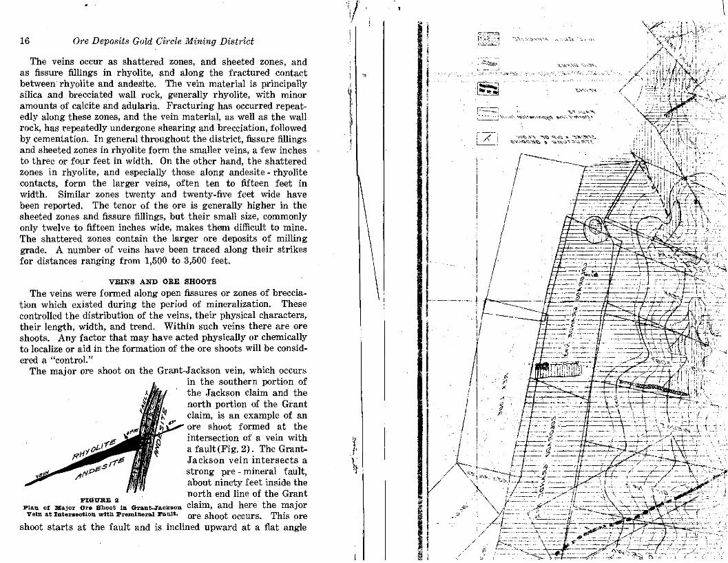
The veins occur as shattered zones, and sheeted zones, and as fissure fillings in rhyolite, and along the fractured contact between rhyolite and andesite. The vein material is principally silica and brecciated wall rock, generally rhyolite, with minor amounts of calcite and adularia. Fracturing has occurred repeat- edly along these zones, and the vein material, as well as the wall rock, has repeatedly undergone shearing and brecciation, followed by cementation. In general throughout the district, fissure fillings and sheeted zones in rhyolite form the smaller veins, a few inches to three or four feet in width. On the other hand, the shattered zones in rhyolite, and especially those along andesite- rhyolite contacts, form the larger veins, often ten to fifteen feet in width. Similar zones twenty and twenty-five feet wide have been reported. The tenor of the ore is generally higher in the sheeted zones and fissure fillings, but their small size, commonly only twelve to fifteen inches wide, makes them difficult to mine. The shattered zones contain the larger ore deposits of milling grade. A number of veins have been traced along their strikes for distances ranging from 1,500 to 3,500 feet.
VEINS AND ORE SHOOTS
The veins were formed along open fissures or zones of breccia- tion which existed during the period of mineralization. These controlled the distribution of the veins, their physical characters, their length, width, and trend. Within such veins there are ore shoots. Any factor that may have acted physically or chemically to localize or aid in the formation of the ore shoots will be consid- ered a "control."
The major ore shoot on the Grant-Jackson vein, which occurs in the southern portion of the Jackson claim and the north portion of the Grant claim, is an example of an ore shoot formed a t the intersection of a vein with a fault (Fig. 2). The Grant- Jackson vein intersects a strong pre - mineral fault, about ninety feet inside the
FIGUEE 2 north end line of the Grant
Plan Of M ~ , ~ . 0.. shoot I. &&llt-JaCY80. claim, and here the major Velll at Iterse~tion wlth PremImral Fault. Ore shoot occurs. This ore
shoot starts a t the fault and is inclined upward at a flat angle

Ore Deposits Gold Circle Mining District 17
toward the north. On the 225 and the 165 levels the stope length of the ore shoot is approximately 100 and 200 feet, respectively. Drifting on the vein and crosscutting have been carried over 500 feet north from the end of the ore shoot on the 165 level, and no important pay shoots have been found outside the zone of influ- ence of the controlling fault structure.
The Grant-Jackson vein is found along a fault contact between andesite and rhyolite. The ore shoot consists of finely brecciated rhyolite, rhyolite boulders seamed with and recemented by sugary quartz and quartz replacing calcite (which was apparently the earlier cement), and sugar-quartz near the andesite footwall. The average width of the vein is about ten feet. North of the ore shoot the vein is narrower and less mineralized.
Two factors were active in the formation of this ore shoot: First, a variation in dip of from 5" t o 10" between the surface and the different levels created a lenticular opening partly filled with brecciated material when movement occurred (Fig. 3). Second, intermineralization movement along the pre-mineral fault aided in keep- ing a passage open within the vein for the circulation of mineralizing and metallizing solutions. This fault forms a zone of intense shearing forty -five to fifty feet wide, striking eastwest and dipping south. Abundant calcite occurs near the footwall X ,
of the fault a t its intersection with the vein. Ore was found within the shear zone for approximately thirty feet south from the footwall. This ore was bunchy and showed indications of disturbance. The hanging wall of the fault is andesite. On the projection of the GrantJackson vein south through the fault a vein was found in the hanging wall block. This consists of about eight inches of quartz between a n d e site walls, with strike and dip the same as
PIGWEE 3 on the vein northof the fault, but this part sec,o Throngh Ma,or of the vein was not thelocus of suchactive ore shoot in *rant-~sckeon
Vein wlth the ruechdes, movement as that north of the fault. I ts w u ~ h aiaaa xn rts Forma-
gold and silver content is low. tion, Illlmstrstea.
Indications are that the vein is younger than the fault and was poorly developed in the soft gouge of the fault zone and to the south of the fault. Slight intermineralization movements on the

18 Ore Deposits Gold Circle Mining District Ore Deposits Gold Circle Mining District 19
fault, centering near the footwall, helped keep a channel open for mineralizing solutions to enter the vein and cement the rock frsg- ments together; for later solutions to replace earlier deposited material, and finally for the metallizing solutions to deposit their load of gold and silver.
The Missing Link vein is a typical fissure filling a t places along a single fissure, and again in a sheeted zone in the wall rock, or in the lamprophyric dike which courses with the vein for some distance. The ore shoots do not show any pronounced control as in the case of the Grant-Jackson ore shoot. The fis- sure filling varies in character and in richness. Generally the pay streaks contain both gold and silver, with the silver predomi- nating, but pay shoots do occur in which either metal may predominate in value. The occurrence of the two types of metalli- zation, separately, in ore shoots within a few feet of each other, indicates two stages of metallization with the possibility of an overlap between them, As a whole the pay streaks are chiefly dependent on gold for their commercial value. This is generally true of the ore shoots throughout the district.
The Elko Prince vein is a fissure filling along a steep fault of considerable displacement, with the June Bell rhyolite on the west wall and the Elko Prince rhyolite on the east wall of the adit or 300 foot level. The vein will average about two feet in width, and commonly, in addition to the siliceous vein matter, there are several inches to a foot or more of gouge developed on the east wall. The walls are firm and well defined. On the adit level mining operations were extended over 1,500 feet along the strike of the vein. The 450 foot and 600 foot levels were extensively worked, but these levels were only briefly examined in 1929 when they were partly reopened. Some mining was done on the 750 foot level, and a winze from the 750 foot to the 900 foot level near the north end of the vein was sunk in ore averaging $75 per ton. The main ore shoot was 630 feet long on the 300 foot level and averaged fifteen inches in width; on the 600 foot level it wag 810 feet long, and'by November, 1917, 230 feet had been opened on the 750 foot level showing an average width of thirty inches.
No definite control is evident for the ore shoot in the Elko Prince vein. The vein varies a s much as 5" either direction from vertical and there are slight variations in the strike, but these have no apparent affect on the metallization.
- -
'Weed, W . H., "The \heNincs Handbook," TO~. SIII , 1918.
The June Bell vein is a fissure filling in rhyolite. The average width of the vein matter is less than a foot. An ore shoot opened in 1929 on the 300 foot level appeared wheresmall step faultx
t offset the vein. The ore shoot continued for 120 feet south of these step faults, to a point where i t was intersected by a fault
:1 with andesite hanging wall, where it turned and followed the fault to the east. Along the fault the ore was in place, but was irregularly developed. A similar occurrence was noted on the 600 foot level a t the south end of the Elko Prince vein, where the same fault was encountered.
Zones of shattered mineralized rhyolite of milling grade along rhyolite-andesite contacts and in rhyolite have been reported along the Gold Crown vein and the Rex lode. These zones are larger than the fissure fillings and range from five to twenty-five feet in width.
.Post-mineral movement along the Gold Crown vein has been reported by Emmons. This was also noted by the author a t the southeast end of the vein, near its intersection with the Colorado Grande fault, which cuts the vein a t a very acute angle and appar- ently terminates it. This fault also shows definite evidence of post-mineral movement. Large, well-rounded boulders of high- grade ore have been found in the soft gouge along the fault, near its intersection with the Gold Crown vein. The ore is typical brecciated vein matter, recemented. I t may have formed in the fault a t the intersection with the vein, and been broken up and rounded by later movement on the fault; or it may have been torn out of the vein as "drag ore" when movement occurred along the fault. The size of the boulders, one of which weighed several tons, would indicate an original deposit of more than average size.
A seam of ore two to three inches wide, assaying several thou- sand dollars per ton, occurs in the Gold Crown vein at its inter- section with the fault. Northwest of the fault, along the vein, the ore feathers out into fine seamlets within twenty-five or thirty feet. This ore is similar mineralogically and comparable in 1 value to the boulders found in the gouge along the fault adjacent
''Y' i t
to and north of the intersection. Surface exposures are poor in this area and underground development is not sufficient to prove definitely whether.this is an ore shoot fomned a t the intersection of the vein with the fault, or that i t represents a segment of a faulted ore shoot. The information available favors the former
! possibility. Southeast of the fault the vein has not been rec- i ognized.


28 Ore Deposits Gold Circle Mining District
this would be to determine the amount of erosion which has taken place since the deposition of the ore. From a study of the veins and the formations, i t appears that the mineralization took place during the period of extensive erosion, following the first period of post-andesite folding and faulting, and prior to the extrusion of the late post-andesite tuffs. All the earlier for- mations were greatly tilted, and faulted prior t o the mineraliza- tion. The ore was deposited along fissures and faults developed during this disturbance. With the present knowledge of the thickness of the formations, their positions and attitudes, i t is difficult to make a reasonably accurate estimate of the thickness of the rock prism that was removed by erosion.
The greatest erosion appears in the vicinity of the Elko Prince vein. Adjacent to the Grant-Jackson vein the formations are less disturbed, and i t is possible to obtain a more definite idea of the extent of erosion. The vein occurs along a normal fault between andesite and early post-andesite rhyolite. On the foot- wall side of the vein, along the ore shoot, the andesite is still capped by fifty to one hundred feet of rhyolite. The amount of erosion is equal to the difference between the thickness of the remaining rhyolite and its original thickness. The thickest expo- sure of this formation is approximately 400 feet. Though this may not represent the original thickness, it appears probable that i t did not greatly exceed that which remains. These deposits therefore must have formed a t relatively shallow depths below the surface.
The mineral associations, the structures in the vein, and the textural features of the vein filling all serve as indicators of the depth a t which the deposits were formed. The typomorphic minerals in these deposits are: Chalcedonic silica, adularia, fine- grained pyrite, stromeyerite, and proustite. The typomorphic structures are chambers, cavities, and open fissures along the vein. In the vein filling there are numerous cavities, delicate banding, and cellular structure. The mineral assemblage, the structures in the vein, and textural features of the vein filling are typical of hydrothermal mineralization a t relatively shallow depths.
These features, taken with the evidence of depth indicated by the amount of erosion, serve to place the deposits in the epither- ma1 type, which is the type of deposit in the mines of Goldfield, the Comstock, Tuscarora, Tonopah, and other important districts of Nevada.
Ore Deposits Gold Circle Mining District 29
SUMMARY AND CONCLUSIONS 1. The terrane examined is one of extensive Tertiary volcanic
activity. I t includes flows of rhyolite and andesite, with which are associated basalt flows and minor amounts of olivine diabase. rhyolite tuff, and rhyolite breccia. Cutting these formations acid and basic dikes are occasionally noted.
2. The volcanic series is divided into three major groups: Pre-andesite or Elko Prince rhyolite, andesite, and post-andesite rhyolite flows and tuff. The andesite overlies the Elko Prince rhyolite with no apparent angular or erosional break. Conform- ably overlying these flows are the early post-andesite rhyolite flows with some interbedded tuff. Intense tilting and faulting followed this period of volcanic activity, ending in mineralization and erosion. After this period of disturbance and erosion, the late post-andesite tuffs covered the region to a depth of several hundred feet. This period was followed by some slight disturb- ance, and the erosion cycle which developed the present topog raphy of the region.
Since the June Bell rhyolite cannot be definitely designated as an intrusive or extrusive mass, i t can be assigned to the pre- mineral division only.
3. The ore deposits of the district occur as fissure fillings. sheeted zones, and shattered zones in rhyolite and along fault
5 contacts between andpsite and rhyolite. The inclosing rocks show . . notable effects of hydrothermal alteration.
4. 4. Generally the ore shoots of the district do not show a. definite control. But in the case of the Grant-Jackson vein the 4$
",:., major ore shoot is controlled by slight flattening in the dip of
.$, the vein, and by a strong premineral fault which intersects the & vein. During mineralization, movement occurred along this fault @. % near the footwall, aiding in the opening of tha t portion of the
.",. vein in the footwall of the fault and keeping a channel open for
& ,% the mineralizing and metallizing solutions. c 5. There were three phases of silica deposition and one of
1 calcite in the veins. The metallization is associated with the latter part of the second, and all of the third phase of silica deposition.
i There is no evidence of metallization associated with the calcite, the last mineral introduced into the veins.
6. The evidence on the amount of erosion, the mineral assem- blage, the structural features of the veins, and the textural char-
(! acter of the vein filling indicate that the formation of these veins took place a t relatively shallow depths below the surface. These veins represent a typical epithermal type of deposit.
I

30 Ore Deposits Gold Circle Mining District
BIBLIOGRAPHY'
Mineral Resources of the United States. U. S. G. S.: 1907 1 348 1912 1 790 1917 1 270-2 1908 1 477 1913 1 820 1918 1 475 1909 1 399 1914 1 675 1919 1 388-9 1910 1 510 1915 1 629-30 1920 1 321 1911 1 671 1916 1 475 1921 1 381
D m , 6. V. N., and Dugan, L. D., "Elko Prince Mine and Mill," Trans. AIME, Vol. 60 (1919), 78-97; Abstmt , Mining and Scientific Press, Vol. 117 (1918), 791.
Dougan, L. D., "The Elko Prince Leasing Company's New Mill," Mining and Engineering World, Vol. 43 (1915), 939.
Emmons, W. H., U. S. G. S. Bull. 408, 48-57, 70. Hill, 6. M., U. S. G. S. Bull. 507, 204. Howell, B. P., "Midas Mill," Discussion, Mining and Scientific
Press, Vol. 110 (1915), 851, 979. Stwzrt, E. E., "Nevada Mineral Resources," Carson City (1909). Weed, W. H., Editor, "The Mines Handbook," Vol. XV, Tucka-
hoe, N. Y. (1922) :
Banberger Ms. Co. Berry M. Co. Eastern Star M. Co. Elko Prince Leasing Co. Elko Prince M. Co. Gold Circle Buick M. Co. Gold Circle Coalition Co. Gold Circle Crown M. Co. Gold Circle Queen M. Co. Rex Ms. Co.
Young, C. 6.. "Cooperation Among Small Mines," Engineering and Mining Journal, Vol. 106 (1918), 813. -- - -
"'Dl~ning Districts and Mineral Resourex of Nevada," by H'rancis Church Lincoln.
NEVADA STATE BUREAU OF MINES AND MACKAY SCHOOL OF MINES PUBLICATIONS
- Mining Districts and Minera1,Resources of Nevada, 1923 ...... $1.50 The Identification of Nevada's Common Minerals, 1928-
.25
.50 Dumortierite, 192 Gratis
.......................... Mineral Resources of Southern Nevada, 1929 Gratis The Underground Geology of the Western Part of the Tono-
................................. pah Mining District, Nevada, 1930 G r a t i s A Preliminary Survey of the Scossa Mining District, Per-
shing County, Nevada, 193 Gratis Notes on Ore Deposits a t Cav
............................................ Lincoln County, Nevada, 1931 Gratis Ore Deposits of the Gold Circle Mining District, Elko
County, Nevada, 193 ratis Bedded Deposits of Manganese Oxides near Las Vegas,
Nevada, 1931 ratis Cherry Creek(Egan Canyon)District,White Pine County,
Nevada, I931 The Spruce Mountain District in Elko County, Nevada, Gratis
1931 .................................................................................


![Types of Ore Deposits[1]](https://img.pdfslide.us/doc/110x75/577ce4001a28abf1038d7c0d/types-of-ore-deposits1.jpg)