Embed Size (px)
Citation preview
160.114
1-13-15
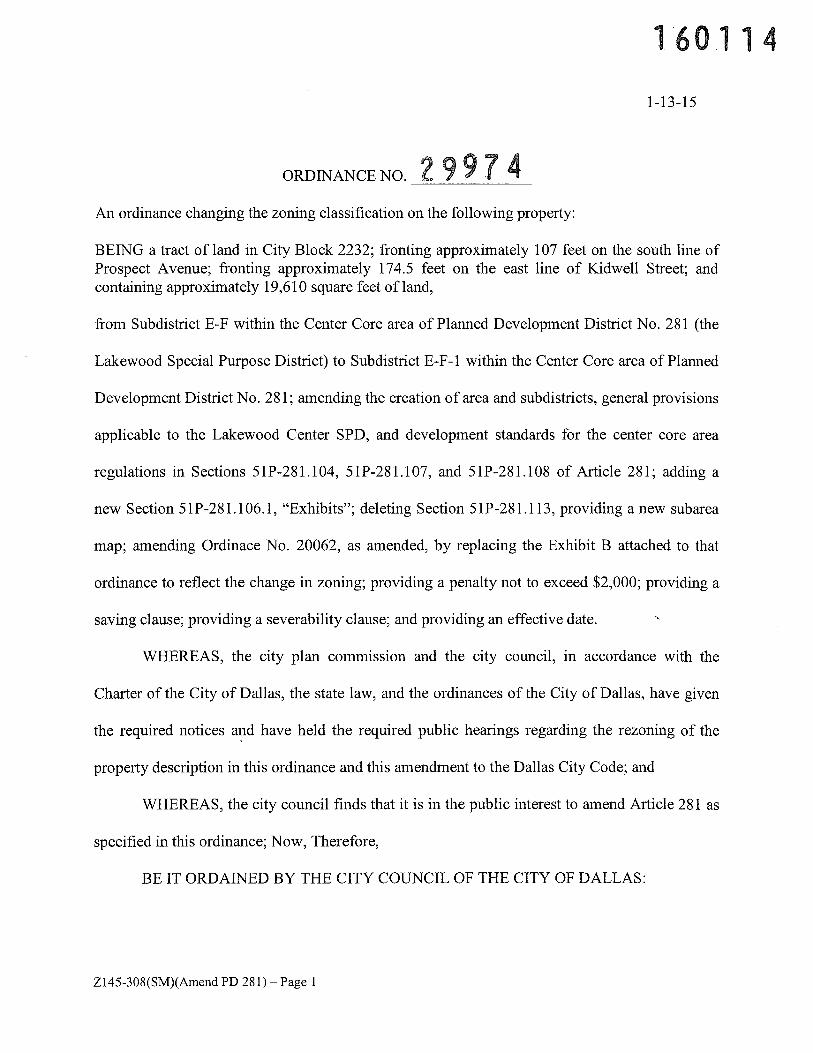
ORDINANCE NO. 2 9 9 7 4An ordinance changing the zoning classification on the following property:
BEING a tract of land in City Block 2232; fronting approximately 107 feet on the south line ofProspect Avenue; fronting approximately 174.5 feet on the east line of Kidwell Street; andcontaining approximately 19,610 square feet of land,
from Subdistrict E-F within the Center Core area of Planned Development District No. 281 (the
Lakewood Special Purpose District) to Subdistrict E-F- 1 within the Center Core area of Planned
Development District No. 281; amending the creation of area and subdistricts, general provisions
applicable to the Lakewood Center SPD, and development standards for the center core area
regulations in Sections 51P-281.104, 51P-281.107, and 51P-281.108 of Article 281; adding a
new Section 51P-281.106.1, “Exhibits”; deleting Section 51P-281.113, providing a new subarea
map; amending Ordinace No. 20062, as amended, by replacing the Exhibit B attached to that
ordinance to reflect the change in zoning; providing a penalty not to exceed $2,000; providing a
saving clause; providing a severability clause; and providing an effective date.
WHEREAS, the city plan commission and the city council, in accordance with the
Charter of the City of Dallas, the state law, and the ordinances of the City of Dallas, have given
the required notices and have held the required public hearings regarding the rezoning of the
property description in this ordinance and this amendment to the Dallas City Code; and
WHEREAS, the city council finds that it is in the public interest to amend Article 281 as
specified in this ordinance; Now, Therefore,
BE IT ORDAINED BY THE CITY COUNCIL OF THE CITY OF DALLAS:
Z145-308(SM)(Amend PD 281) — Page 1
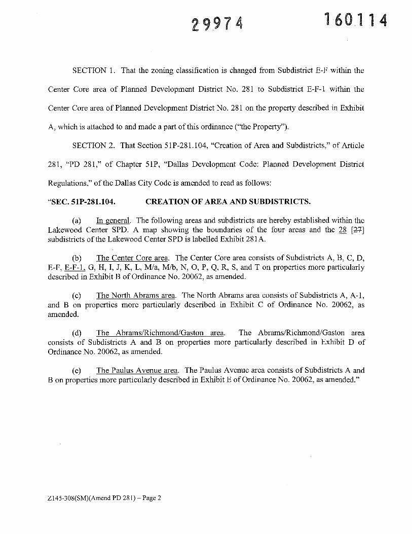
29974 160114
SECTION 1. That the zoning classification is changed from Subdistrict E-F within the
Center Core area of Planned Development District No. 281 to Subdistrict E-F-1 within the
Center Core area of Planned Development District No. 281 on the property described in Exhibit
A, which is attached to and made a part of this ordinance (“the Property”).
SECTION 2. That Section 51 P-28 1.104, “Creation of Area and Subdistricts,” of Article
281, “PD 281,” of Chapter SiP, “Dallas Development Code: Planned Development District
Regulations,” of the Dallas City Code is amended to read as follows:
“SEC. 51P-281.104. CREATION OF AREA AND SUBDISTRICTS.
(a) In general. The following areas and subdistricts are hereby established within theLakewood Center SPD. A map showing the boundaries of the four areas and the 28 [2-7]subdistricts of the Lakewood Center SPD is labelled Exhibit 281A.
(b) The Center Core area. The Center Core area consists of Subdistricts A, B, C, D,E-F, E-F-1, G, H, I, J, K, L, M/a, M/b, N, 0, P, Q, R, 5, and T on properties more particularlydescribed in Exhibit B of Ordinance No. 20062, as amended.
(c) The North Abrams area. The North Abrams area consists of Subdistricts A, A-i,and B on properties more particularly described in Exhibit C of Ordinance No. 20062, asamended.
(d) The Abrams/Richmond/Gaston area. The Abrams/Richmond/Gaston areaconsists of Subdistricts A and B on properties more particularly described in Exhibit D ofOrdinance No. 20062, as amended.
(e) The Paulus Avenue area. The Paulus Avenue area consists of Subdistricts A andB on properties more particularly described in Exhibit E of Ordinance No. 20062, as amended.”
Z145-308(SM)(Amend PD 281)— Page 2
2997 160114
SECTION 3. That Article 281, “PD 281,” of Chapter 51P, “Dallas Development Code:
Planned Development District Regulations,” of the Dallas City Code is amended by adding a
new Section 51P-281.106.1, “Exhibits,” to read as follows:
“SEC. 51P-281.106.1. EXHIBITS.
The following exhibits are incorporated into this article:
(1) Exhibit 281A: subarea map.
(2) Exhibit 28 1B: Paulus Avenue elevations.
(3) Exhibit 281C: Abrams Road elevation concept sketch (proposed retail).
(4) Exhibit 281D: Abrams Road elevation concept sketch (proposed bank).
(5) Exhibit 281 E: Subdistrict A-i development plan and landscape plan.
(6) Exhibit 281 F: photos of existing structure and existing canopy.”
SECTION 4. That Subsection (a), “Definitions,” of Section 51 P-28 1.107, “General
Provisions Applicable to the Lakewood Center SPD,” of Article 281, “PD 281,” of Chapter 51P,
“Dallas Development Code: Planned Development District Regulations,” of the Dallas City
Code is amended by adding a new Paragraph (66) to read as follows:
“(66) WINERY AND TASTING ROOM means a facility for the manufacture,blending, fermentation, processing, packaging, and consumption of wine. A winery and tastingroom use includes but is not limited to hosting event meetings, food preparation and service,outdoor consumption, and retail sales for off-premise consumption and related items, inaccordance with Texas Alcoholic Beverage Commission regulations.”
Z145-308(SM)(Amend PD 281)— Page 3
2997 160114
SECTION 5. That Paragraph (4), “Restaurant, Food, and Drink Service Uses,” of
Subsection (g) of Section 51 P-28 1 .107, “General Provisions Applicable to the Lakewood Center
SPD,” of Article 281, “PD 281,” of Chapter 51P, “Dallas Development Code: Planned
Development District Regulations,” of the Dallas City Code is amended to read as follows:
“(4) Restaurant, food, and drink service uses.
-- Bakery or confectionery shop.-- Private club. [SUP]-- Catering service.-- Restaurant with alcoholic beverages.-- Restaurant with alcoholic beverages and entertainment. [SUP]-- Restaurant with drive-through service. [RAR]-- Winery and tasting room. [Limited to Subdistrict E-F-1 only.
SUP!”
SECTION 6. That Paragraph (2), “Height and Stories,” of Subsection (a), “Height and
Story Standards in the Center Core Area,” of Section 5 1P-28 1.108, “Development Standards for
the Center Core Area,” of Article 281, “PD 281,” of Chapter 51P, “Dallas Development Code:
Planned Development District Regulations,” of the Dallas City Code is amended to read as
follows:
“(2) Height and stories. Unless further restricted under Paragraph (1),maximum height and number of stories allowed in all subdistricts of the center core area are asfollows:
Maximum Maximum NumberSubdistrict Height (In feet) of StoriesA, B, E-F, E-F.-1G, and M/a 75 5
C 125 9
DandQ 60 4
H, I, M/b, 0,P,R,S,andT 50 3
JandN 36 2
Z145-308(SM)(Amend PD 281)— Page 4
2997 160114
K 75 5
L 90 7”
SECTION 7. That Subsection (c), “Lot Coverage in the Center Core Area,” of Section
5lP-281.108, “Development Standards for the Center Core Area,” of Article 281, “PD 281,” of
Chapter 51P, “Dallas Development Code: Planned Development District Regulations,” of the
Dallas City Code is amended to read as follows:
“(c) Lot coverage in the center core area. Maximum lot coverage for building sites inall subdistricts of the center core area is as follows:
Subdistrict Maximum Lot Coverage(in percent)
A, B, C, E-F, E-F-1, G, 12K, M/a, Q, and S 80
D, H, M/b, N, 0,P,R,andT 70
J 40
L 60”
SECTION 8. That Paragraph (1), “General Standards,” of Subsection (e), “Maximum
Floor Area Ratios in the Center Core Area,” of Section 51P-281.108, “Development Standards
for the Center Core Area,” of Article 281, “PD 281,” of Chapter 51P, “Dallas Development
Code: Planned Development District Regulations,” of the Dallas City Code is amended to read
as follows:
“(1) General standards. Maximum floor area ratios for building sites in allsubdistricts of the center core area are as follows:
Maximum FloorSubdistrict Area Ratio
A,B,G,andK 2.0C 2.5
Z145-308(SM)(AmendPD 281)—Page 5
297 160114
D, E-F, EF1g L, Q, and S 1.5H, I, M/b, N, 0, P, R, and T 1.0J 0.8MIa 1.5”
SECTION 9. That Item (i) of Subparagraph (A), “Retail and Service Use Bonus,” of
Paragraph (2), “Special Provisions,” of Subsection (e), “Maximum Floor Area Ratios in the
Center Core Area,” of Section 51P-281 .108, “Development Standards for the Center Core Area,”
of Article 281, “PD 281,” of Chapter 51P, “Dallas Development Code: Planned Development
District Regulations,” of the Dallas City Code is amended to read as follows:
“(i) Maximum floor area ratios provided in Paragraph (1) maybe increased in Subdistricts A, B, E-F, E-F-1, G, H, I, K, M/a, Q, and R if:
(aa) the amount of floor area designated for retail andservice uses exceeds that required in the ground floor use requirement contained in Subsection(k)(2); and
(bb) an exterior entrance accessible from a city sidewalkis provided for all retail and service uses in excess of the ground floor use requirement. Anexterior entrance that requires passage through a lobby serving multiple uses does not satisfy thisrequirement.”
SECTION 10. That Item (ii), Transfer Allowed,” of Subparagraph (B), “Transfer of
Development Rights From Subdistrict J,” of Paragraph (2), “Special Provisions,” of Subsection
(e), “Maximum Floor Area Ratios in the Center Core Area,” of Section 51P-281.108,
“Development Standards for the Center Core Area,” of Article 281, “PD 281,” of Chapter 51P,
“Dallas Development Code: Planned Development District Regulations,” of the Dallas City
Code is amended to read as follows:
“(ii) Transfer allowed. If the Lakewood Theater and the formercity library structures are preserved in accordance with this subparagraph, square footagereflecting up to a floor area ratio of 1.2 may be transferred from each of the building sites wherethose structures are located to building sites in Subdistricts A, B, E-F, E-F-1, G, H, I, K, M/a, Q,or R.”
Z145-308(SM)(Amend PD 281) — Page 6
2997k 160114
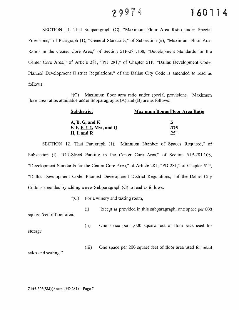
SECTION 11. That Subparagraph (C), “Maximum Floor Area Ratio under Special
Provisions,” of Paragraph (1), “General Standards,” of Subsection (e), “Maximum Floor Area
Ratios in the Center Core Area,” of Section 51 P-28 1.108, “Development Standards for the
Center Core Area,” of Article 281, “PD 281,” of Chapter 51P, “Dallas Development Code:
Planned Development District Regulations,” of the Dallas City Code is amended to read as
follows:
“(C) Maximum floor area ratio under special provisions. Maximumfloor area ratios attainable under Subparagraphs (A) and (B) are as follows:
Subdistrict Maximum Bonus Floor Area Ratio
A,B,G,andK .5E-F, E-F-1, M/a, and Q .375H, I, and R .25”
SECTION 12. That Paragraph (1), “Minimum Number of Spaces Required,” of
Subsection (f), “Off-Street Parking in the Center Core Area,” of Section 51P-281.108,
“Development Standards for the Center Core Area,” of Article 281, “PD 281,” of Chapter SiP,
“Dallas Development Code: Planned Development District Regulations,” of the Dallas City
Code is amended by adding a new Subparagraph (G) to read as follows:
“(G) For a winery and tasting room,
(i) Except as provided in this subparagraph, one space per 600square feet of floor area.
(ii) One space per 1,000 square feet of floor area used forstorage.
(iii) One space per 200 square feet of floor area used for retailsales and seating.”
Z145-308(SM)(Amend PD 281)—Page 7
2997 160114
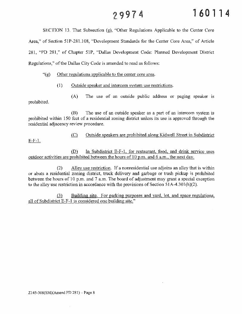
SECTION 13. That Subsection (g), “Other Regulations Applicable to the Center Core
Area,” of Section 51P-281 .108, “Development Standards for the Center Core Area,” of Article
281, “PD 281,” of Chapter 51P, “Dallas Development Code: Planned Development District
Regulations,” of the Dallas City Code is amended to read as follows:
“(g) Other regulations applicable to the center core area.
(1) Outside speaker and intercom system use restrictions.
(A) The use of an outside public address or paging speaker isprohibited.
(B) The use of an outside speaker as a part of an intercom system isprohibited within 150 feet of a residential zoning district unless its use is approved through theresidential adjacency review procedure.
Outside speakers are prohibited along Kidwell Street in SubdistrictE-F--1.
In Subdistrict E-F- 1, for restaurant, food, and drink service usesoutdoor activities are prohibited between the hours of 10 p.m. and 6 a.m., the next day.
(2) Alley use restriction. If a nonresidential use adjoins an alley that is withinor abuts a residential zoning district, truck delivery and garbage or trash pickup is prohibitedbetween the hours of 10 p.m. and 7 a.m. The board of adjustment may grant a special exceptionto the alley use restriction in accordance with the provisions of Section 51A-4.301(h)(2).
Building site. For parking purposes and yard, lot, and space regulations,all of Subdistrict E-F-1 is considered one building site.”
Z145-308(SM)(AmendPD 281)—Page 8
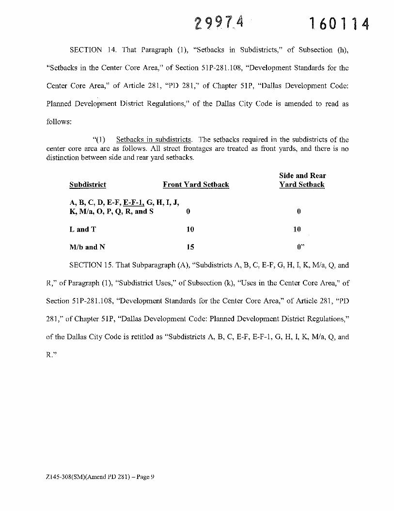
2997A 160114SECTION 14. That Paragraph (1), “Setbacks in Subdistricts,” of Subsection (h),
“Setbacks in the Center Core Area,” of Section 51P-281.l08, “Development Standards for the
Center Core Area,” of Article 281, “PD 281,” of Chapter 51P, “Dallas Development Code:
Planned Development District Regulations,” of the Dallas City Code is amended to read as
follows:
“(1) Setbacks in subdistricts. The setbacks required in the subdistricts of thecenter core area are as follows. All street frontages are treated as front yards, and there is nodistinction between side and rear yard setbacks.
Side and RearSubdistrict Front Yard Setback Yard Setback
A, B, C, D, E-F, E-F-1, G, H, I, J,K, M/a, 0, P, Q, R, and 5 0 0
LandT 10 10
M/bandN 15 0”
SECTION 15. That Subparagraph (A), “Subdistricts A, B, C, E-F, G, H, I, K, M/a, Q, and
R,” of Paragraph (1), “Subdistrict Uses,” of Subsection (k), “Uses in the Center Core Area,” of
Section 51P-28l.108, “Development Standards for the Center Core Area,” of Article 281, “PD
281,” of Chapter 51P, “Dallas Development Code: Planned Development District Regulations,”
of the Dallas City Code is retitled as “Subdistricts A, B, C, E-F, E-F-1, G, H, I, K, M/a, Q, and
R.”
Z145-308(SM)(Amend PD 281) —Page 9
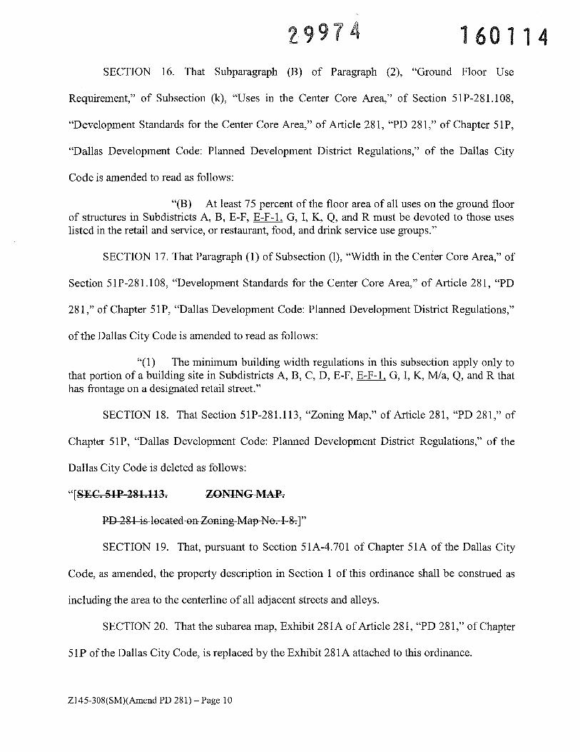
2997 160114SECTION 16. That Subparagraph (B) of Paragraph (2), “Ground Floor Use
Requirement,” of Subsection (k), “Uses in the Center Core Area,” of Section 51P-281.108,
“Development Standards for the Center Core Area,” of Article 281, “PD 281,” of Chapter 51P,
“Dallas Development Code: Planned Development District Regulations,” of the Dallas City
Code is amended to read as follows:
“(B) At least 75 percent of the floor area of all uses on the ground floorof structures in Subdistricts A, B, E-F, E-F-1. G, I, K, Q, and R must be devoted to those useslisted in the retail and service, or restaurant, food, and drink service use groups.”
SECTION 17. That Paragraph (1) of Subsection (1), “Width in the Center Core Area,” of
Section 51P-281.108, “Development Standards for the Center Core Area,” of Article 281, “PD
281,” of Chapter 51P, “Dallas Development Code: Planned Development District Regulations,”
of the Dallas City Code is amended to read as follows:
“(1) The minimum building width regulations in this subsection apply only tothat portion of a building site in Subdistricts A, B, C, D, E-F, E-F-l, G, I, K, M/a, Q, and R thathas frontage on a designated retail street.”
SECTION 18. That Section 51P-281.113, “Zoning Map,” of Article 281, “PD 281,” of
Chapter 51P, “Dallas Development Code: Planned Development District Regulations,” of the
Dallas City Code is deleted as follows:
“[SEC. 51P 281.113. ZONINC MAP.
PD 281 is located on Zoning Map No. I 8.]”
SECTION 19. That, pursuant to Section 51A-4.701 of Chapter 51A of the Dallas City
Code, as amended, the property description in Section 1 of this ordinance shall be construed as
including the area to the centerline of all adjacent streets and alleys.
SECTION 20. That the subarea map, Exhibit 281A of Article 281, “PD 281,” of Chapter
5lP of the Dallas City Code, is replaced by the Exhibit 281A attached to this ordinance.
Z145-308(SM)(Amend PD 281)— Page 10
2997 160114SECTION 21. That the Exhibit B attached to Ordinance No. 20062, as amended, passed
by the Dallas City Council on September 4, 1988, is replaced by the Exhibit B attached to this
ordinance.
SECTION 22. That a person who violates a provision of this ordinance, upon conviction,
is punishable by a fine not to exceed $2,000.
SECTION 23. That Chapter 51P of the Dallas City Code, as amended, shall remain in
full force and effect, save and except as amended by this ordinance.
SECTION 24. That the terms and provisions of this ordinance are severable and are
governed by Section 1-4 of Chapter 1 of the Dallas City Code, as amended.
SECTION 25. That this ordinance shall take effect immediately from and after its
passage and publication, in accordance with the Charter of the City of Dallas, and it is
accordingly so ordained.
Passed
APPROVED AS TO FORM:
S. ERNST, City Attorney
AsisanPeit\Attorn)Y
JAN 132016
Z145-308(SM)(Amend PD 281) — Page 11
29974 160114GIS_Approved
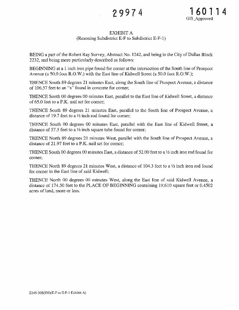
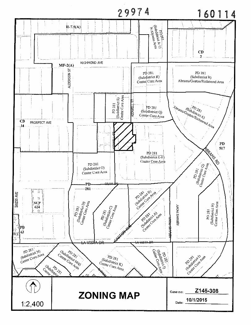
EXHIBIT A(Rezoning Subdistrict E-F to Subdistrict E-F-1)
BEING a part of the Robert Ray Survey, Abstract No. 1242, and being in the City of Dallas Block2232, and being more particularly described as follows:
BEGINNING at a 1 inch iron pipe found for corner at the intersection of the South line of ProspectAvenue (a 50.0 foot R.O.W.) with the East line of Kidwell Street (a 50.0 foot R.O.W.);
THENCE South 89 degrees 21 minutes East, along the South line of Prospect Avenue, a distanceof 106.57 feet to an “x” found in concrete for corner;
THENCE South 00 degrees 00 minutes East, parallel to the East line of Kidwell Street, a distanceof 65.0 feet to a P.K. nail set for corner;
THENCE South 89 degrees 21 minutes East, parallel to the South line of Prospect Avenue, adistance of 19.7 feet to a ½ inch rod found for corner;
THENCE South 00 degrees 00 minutes East, parallel with the East line of Kidwell Street, adistance of 57.5 feet to a ½ inch square tube found for corner;
THENCE North 89 degrees 21 minutes West, parallel with the South line of Prospect Avenue, adistance of 21.97 feet to a P.K. nail set for corner;
THENCE South 00 degrees 00 minutes East, a distance of 52.00 feet to a ½ inch iron rod found forcorner;
THENCE North 89 degrees 21 minutes West, a distance of 104.3 feet to a ½ inch iron rod foundfor corner in the East line of said Kidwell;
THENCE North 00 degrees 00 minutes West, along the East line of said Kidwell Avenue, adistance of 174.50 feet to the PLACE OF BEGINNING containing 19,610 square feet or 0.4502acres of land, more or less.
Z145-308(SM)(E-F to E-F-1 Exhibit A)
GIS Approved
1.60114
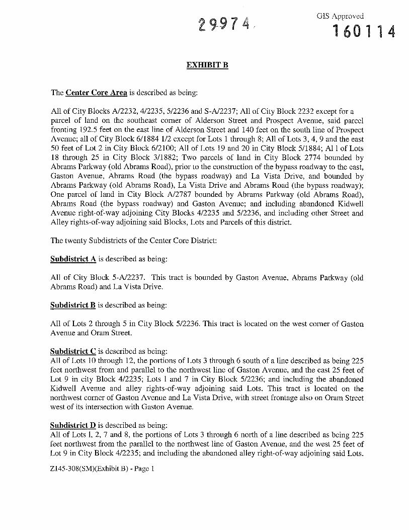
EXifiBIT B
The Center Core Area is described as being:
All of City Blocks A12232, 4/2235, 5/2236 and S-A12237; All of City Block 2232 except for aparcel of land on the southeast corner of Alderson Street and Prospect Avenue, said parcelfronting 192.5 feet on the east line of Alderson Street and 140 feet on the south line of ProspectAvenue; all of City Block 6/1884 1/2 except for Lots 1 through 8; All of Lots 3, 4, 9 and the east50 feet of Lot 2 in City Block 6/2100; All of Lots 19 and 20 in City Block 5/1884; Al 1 of Lots18 through 25 in City Block 3/1882; Two parcels of land in City Block 2774 bounded byAbrams Parkway (old Abrams Road), prior to the construction of the bypass roadway to the east,Gaston Avenue, Abrams Road (the bypass roadway) and La Vista Drive, and bounded byAbrams Parkway (old Abrams Road), La Vista Drive and Abrams Road (the bypass roadway);One parcel of land in City Block A12787 bounded by Abrams Parkway (old Abrams Road),Abrams Road (the bypass roadway) and Gaston Avenue; and including abandoned KidwellAvenue right-of-way adjoining City Blocks 4/2235 and 5/2236, and including other Street andAlley rights-of-way adjoining said Blocks, Lots and Parcels of this district.
The twenty Subdistricts of the Center Core District:
Subdistrict A is described as being:
All of City Block 5-A12237. This tract is bounded by Gaston Avenue, Abrams Parkway (oldAbrams Road) and La Vista Drive.
Subdistrict B is described as being:
All of Lots 2 through 5 in City Block 5/2236. This tract is located on the west corner of GastonAvenue and Oram Street.
Subdistrict C is described as being:All of Lots 10 through 12, the portions of Lots 3 through 6 south of a line described as being 225feet northwest from and parallel to the northwest line of Gaston Avenue, and the east 25 feet ofLot 9 in city Block 4/2235; Lots 1 and 7 in City Block 5/2236; and including the abandonedKidwell Avenue and alley rights-of-way adjoining said Lots. This tract is located on thenorthwest corner of Gaston Avenue and La Vista Drive, with street frontage also on Oram Streetwest of its intersection with Gaston Avenue.
Subdistrict D is described as being:All of Lots 1, 2, 7 and 8, the portions of Lots 3 through 6 north of a line described as being 225feet northwest from the parallel to the northwest line of Gaston Avenue, and the west 25 feet ofLot 9 in City Block 4/2235; and including the abandoned alley right-of-way adjoining said Lots.
Z145-308(SM)(Exhibit B) - Page 1
GIS Approved
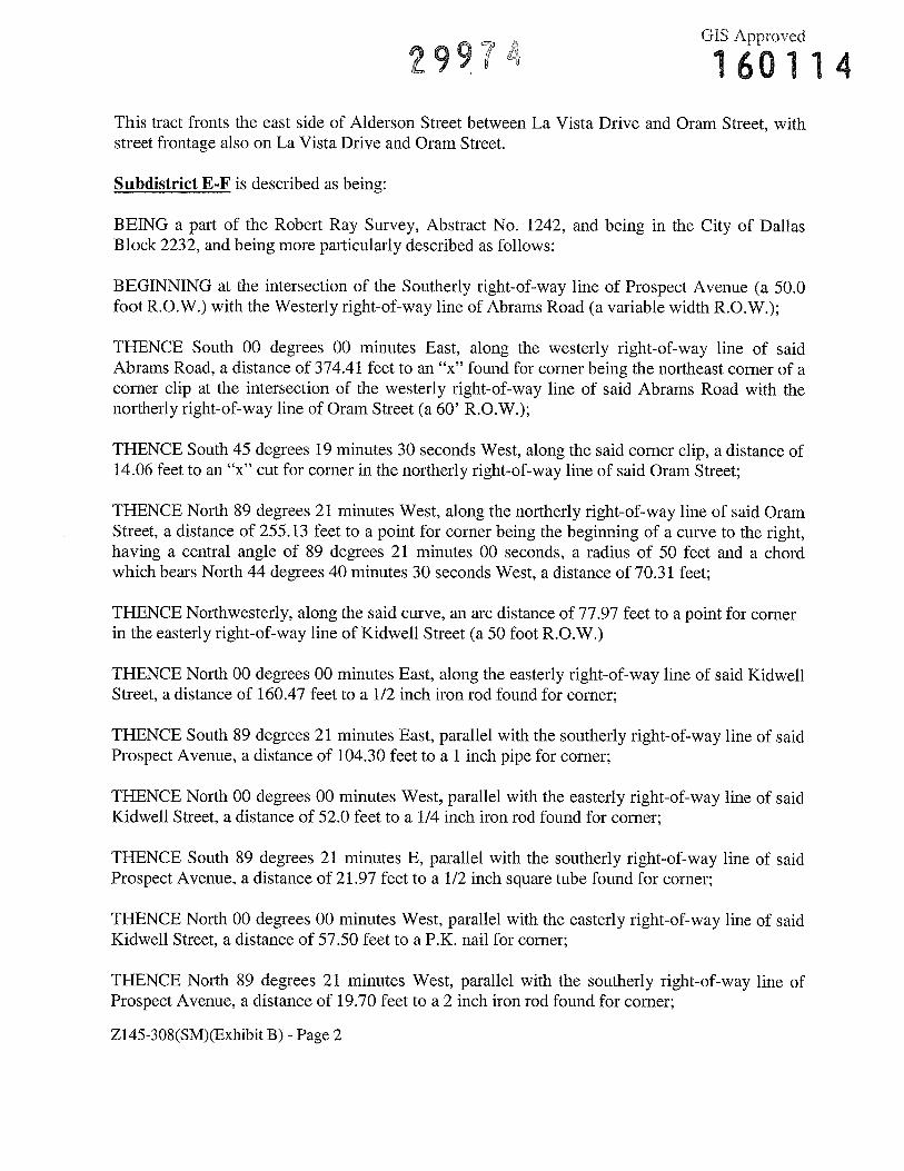
2974 160114This tract fronts the east side of Alderson Street between La Vista Drive and Oram Street, withstreet frontage also on La Vista Drive and Oram Street.
Subdistrict E-F is described as being:
BEING a part of the Robert Ray Survey, Abstract No. 1242, and being in the City of DallasBlock 2232, and being more particularly described as follows:
BEGINNING at the intersection of the Southerly right-of-way line of Prospect Avenue (a 50.0foot R.O.W.) with the Westerly right-of-way line of Abrams Road (a variable width R.O.W.);
THENCE South 00 degrees 00 minutes East, along the westerly right-of-way line of saidAbrams Road, a distance of 374.41 feet to an “x” found for corner being the northeast corner of acorner clip at the intersection of the westerly right-of-way line of said Abrams Road with thenortherly right-of-way line of Oram Street (a 60’ R.O.W.);
THENCE South 45 degrees 19 minutes 30 seconds West, along the said corner clip, a distance of14.06 feet to an “x” cut for corner in the northerly right-of-way line of said Oram Street;
THENCE North 89 degrees 21 minutes West, along the northerly right-of-way line of said OramStreet, a distance of 255.13 feet to a point for corner being the beginning of a curve to the right,having a central angle of 89 degrees 21 minutes 00 seconds, a radius of 50 feet and a chordwhich bears North 44 degrees 40 minutes 30 seconds West, a distance of 70.31 feet;
THENCE Northwesterly, along the said curve, an arc distance of 77.97 feet to a point for cornerin the easterly right-of-way line of Kidwell Street (a 50 foot R.O.W.)
THENCE North 00 degrees 00 minutes East, along the easterly right-of-way line of said KidwellStreet, a distance of 160.47 feet to a 1/2 inch iron rod found for corner;
THENCE South 89 degrees 21 minutes East, parallel with the southerly right-of-way line of saidProspect Avenue, a distance of 104.30 feet to a 1 inch pipe for corner;
THENCE North 00 degrees 00 minutes West, parallel with the easterly right-of-way line of saidKidwell Street, a distance of 52.0 feet to a 1/4 inch iron rod found for corner;
THENCE South 89 degrees 21 minutes E, parallel with the southerly right-of-way line of saidProspect Avenue, a distance of 21.97 feet to a 1/2 inch square tube found for corner;
THENCE North 00 degrees 00 minutes West, parallel with the easterly right-of-way line of saidKidwell Street, a distance of 57.50 feet to a P.K. nail for corner;
THENCE North 89 degrees 21 minutes West, parallel with the southerly right-of-way line ofProspect Avenue, a distance of 19.70 feet to a 2 inch iron rod found for corner;
Z145-308(SM)(Exhibit B) - Page 2
GIS Approved
2997 160114
THENCE North 00 degrees 00 minutes West, parallel with the easterly right-of-way line of saidKidwell Avenue, a distance of 65.0 feet to a 2 inch iron rod for corner in the southerly right-of-way line of said Prospect Avenue;
THECE South 89 degrees 21 minutes E, along the southerly right-of-way line of said ProspectAvenue, a distance of 208.0 feet to the PLACE OF BEGINNING containing 100,732 square feetor 2.3125 acres of land, more or less.
Subdistrict E-F-1 is described as being:
BEING a part of the Robert Ray Survey, Abstract No. 1242, and being in the City of DallasBlock 2232, and being more particularly described as follows:
BEGINNING at a 1 inch iron pipe found for corner at the intersection of the South line ofProspect Avenue (a 50.0 foot R.O.W.) with the East line of Kidwell Street (a 50.0 foot R.O.W.);
THENCE South 89 degrees 21 minutes East, along the South line of Prospect Avenue, a distanceof 106.57 feet to an “x” found in concrete for corner;
THENCE South 00 degrees 00 minutes East, parallel to the East line of Kidwell Street, adistance of 65.0 feet to a P.K. nail set for corner;
THENCE South 89 degrees 21 minutes East, parallel to the South line of Prospect Avenue, adistance of 19.7 feet to a ½ inch rod found for corner;
THENCE South 00 degrees 00 minutes East, parallel with the East line of Kidwell Street, adistance of 57.5 feet to a ½ inch square tube found for corner;
THENCE North 89 degrees 21 minutes West, parallel with the South line of Prospect Avenue, adistance of 21.97 feet to a P.K. nail set for corner;
THENCE South 00 degrees 00 minutes East, a distance of 52.00 feet to a ½ inch iron rod foundfor corner;
THENCE North 89 degrees 21 minutes West, a distance of 104.3 feet to a ½ inch iron rod foundfor corner in the East line of said Kidwell;
THENCE North 00 degrees 00 minutes West, along the East line of said Kidwell Avenue, adistance of 174.50 feet to the PLACE OF BEGINNING containing 19,610 square feet or 0.4502acres of land, more or less.
Subdistrict G is described as being:
Z145-308(SM)(Exhibit B) - Page 3
GIS Approved
29974 160114The portion of City Block 2774, north of La Vista Drive and south of the intersection of GastonAvenue and Abrams Road (the bypass), and west and northwest of a line described as being 175feet east from and parallel to the east line of Abrams Parkway (old Abrams Road) and 200 feetsoutheast from and parallel to the southeast line of Gaston Avenue. This tract is located on thesoutheast corner of Abrams Parkway (old Abrams Road) and Gaston Avenue, with streetfrontage also on Abrams Road (the bypass) and La Vista Drive.
Subdistrict H is described as being:
The portion of City Block 2774, north of La vista Drive and west of Abrams Road (the bypass),excluding the parcel of land described above as being Subdistrict G. This tract is located on thenorthwest corner of Abrams Road (the bypass) and La Vista Drive.
Subdistrict I is described as being:
The portion of City Block 2774, northwest of the Abrams Road (the bypass) and south of LaVista Drive. This tract is bounded by Abrams Parkway (old Abrams Road), La Vista Drive andAbrams Road (the bypass).
Subdistrict J is described as being:
The portion of City Block 6 /1884 1/ 2 within the following boundary:
BEGINNING at the point of intersection line of south line of La Vista Drive and southwest lineof an intersection cut-off, said point being located 10.9 feet west of the west line of AbramsParkway (old Abrams Road);
TFIENCE, in a southeast direction a long said intersection cut-off line a distance of 14.14 feet toits point of intersection with the west line of Abrams Parkway (old Abrams Road);
THENCE, in a south direction along said line of Abrams Parkway (old Abrams Road) a distanceof 370.0 feet to its point of intersection with the northeast line of an alley right-of-way, saidright-of-way line being located 157.5 feet northeast of and parallel to the northeast line of PaulusAvenue;
THENCE, in a northwest direction along said alley right-of-way line a distance of 199.5 feet toits point of intersection with a line defined as being the northwest line of the Lakewood Theaterparcel;
THENCE, in a northeast direction along said Theater parcel line and its prolongation a distanceof 102.5 feet to its point of intersection with a property line, said property line being located260.0 feet northeast from and parallel to the northeast line of Paulus Avenue;
THENCE, in a northwest direction a long said property line a distance of approximately 222.0
Z145-308(SM)(Exhibit B) - Page 4
GIS Approved
2997 i6O114feet to its point of intersection with the south line of La Vista Drive, said point being located123.8 feet east of the intersection of the south line of La Vista Drive with the southeast line ofGaston Avenue;
THENCE, in an east direction along said line of La Vista Drive a distance of 215.8 feet to itspoint of intersection with the southwest line of an intersection cut-off, the PLACE OFBEGINNING. This tract is located on the southwest corner of La Vista Drive and AbramsParkway (old Abrams Road).
Subdistrict K is described as being:
The portion of City Block 611884 1/ 2, including all of Lots 9 and 10, within the followingboundary:
BEGINNING at the point of intersection of the south line of La Vista Drive and the southeastline of Gaston Avenue;
THENCE, in a southwest direction along said line of Gaston Avenue a distance of 169.7 feet toits point of intersection with the northeast line of Paulus Avenue;
THENCE, in a southeast direction along said line of Paulus Avenue a distance of 180.8 feet toits point of intersection with the northwest line of an alley right-of-way;
THENCE, in a northeast direction along said alley right-of-way line a distance of 157.5 feet to acorner point in said alley right-of-way line;
THENCE, in a southeast direction from said alley right-of-way line corner point along thenortheast line of said alley right-of-way to its point of intersection with a line defined as beingthe northwest line of the Lakewood Theater parcel, said point being located 199.5 feet northwestof the intersection of said alley right-of-way line and the west line of Abrams Parkway (oldAbrams Road);
THENCE, in a northeast direction along said Theater parcel line and its prolongation a distanceof 102.5 feet to its point of intersection with a property line, said property line being located260.0 feet northeast from and parallel to the northeast line of Paulus Avenue;
THENCE, in a northwest direction along said property line a distance of approximately222.00 feet to its point of intersection with the south line of La Vista Drive, said point beinglocated 226.7 feet west of the intersection of the south line of La Vista Drive with the west lineof Abrams Parkway (old Abrams Road);
THENCE, in a west direction along said line of La Vista Drive a distance of 123.8 feet to itspoint of intersection with the southeast line of Gaston Avenue, the PLACE OF BEGINNING.This tract is located on the southeast corner of Gaston Avenue and La Vista Drive, with street
Z145-308(SM)(Exhibit B) - Page 5
2 9 9 7 4 G1S Approved
160114frontage also on Paulus Avenue.
Subdistrict L is described as being:
All of Lot 20 and the northeast 65 feet of Lot 19 in City Block 5/1884. This tract is located onthe south corner of Gaston Avenue and Paulus Avenue.
Subdistrict 1’1/a is described as being:
All of Lots 20 and 21 in City Block 3/1882. This tract is located on the west corner of GastonAvenue and Paulus Avenue,
Subdistrict MJb is described as being:
All of Lot 19 and the northeast 69.65 feet of Lot 18 in City Block 3/1882. This tract fronts thenorthwest side of Gaston Avenue, southwest of Paulus Avenue.
Subdistrict N is described as being:
All of Lots 22 through 25 in City Block 3/1882. This tract fronts the south side of La VistaDrive, west of Paulus Avenue.
Subdistrict 0 is described as being:
All of Lot 1 in City Block 2232. This tract fronts the north side of Oram Street, betweenAlderson Street and Kidwell Avenue, with street frontage also on Alderson Street and KidwellAvenue.
Subdistrict P is described as being:
The portion of City Block 2232 within the following boundary:
BEGINNING at the point of intersection of the south line of Prospect Avenue and the west 1 incof Kidwell Avenue;
THENCE, in a south direction along said line of Kidwell Avenue a distance of 185 feet to apoint for corner, said point being in the east prolongation of the north line of Lot 1 in City Block2232;
THENCE, in a west direction along said line of Lot 1 and its prolongation a distance of 90.18feet to its point of intersection with a property line, said property line being located 140 feet eastof and parallel to the east line of Alderson Street;
THENCE, in a north direction along said property line a distance of 185 feet to its point of
Z145-308(SM)(Exhibit B) - Page 6
2 9 9 7 GIS Approved
160114intersection with the south line of Prospect Avenue;
THENCE, in an east direction along said line of Prospect Avenue a distance of 88.8 feet to itspoint of intersection with the west line of Kidwell Avenue, the PLACE OF BEGINNING. Thistract is located on the southwest corner of Prospect Avenue and Kidwell Avenue.
Subdistrict 0 is described as being:
The portion of Lot 9 in City Block 6/2 100 within the following boundary:
BEGINNING at the point of intersection of the west line of Abrams Road (the bypass) and thenorth line of Prospect Avenue;
THENCE, in a north direction along said line of Abrams Road a distance of 180.3 feet to a pointfor corner, said point being located 184.0 feet south of the south line of Richmond Avenue;
THENCE, in a west direction from said corner point a distance of 186.5 feet to a point for cornerin the east line of Kidwell Avenue, said point being located 183.93 feet south of the south line ofRichmond Avenue;
THENCE, in a south direction from said corner point along said line of Kidwell Avenue adistance of 180 feet to its point of intersection with the north line of Prospect Avenue;
THENCE, in an east direction along said line of Prospect Avenue a distance of 186.5 feet to itspoint of intersection with the west line of Abrams Road (the bypass), the PLACE OFBEGINNING. This tract is located on the south half of Lot 9; the tract fronts the north side ofProspect Avenue, between Abrams Road (the bypass) and Kidwell Avenue, with street frontagealso on Abrams Road and Kidwell Avenue.
Subdistrict R is described as being:
The portion of Lot 9 in City Block 6/2 100 remaining after excluding the parcel of land describedabove as being Subdistrict Q. This tract is located on the north half of Lot 9; the tract fronts thesouth side of Richmond Avenue, between Abrams Road (the bypass) and Kidwell Avenue, withstreet frontage also on Abrams Road and Kidwell Avenue.
Subdistrict S is described as being:
All of Lot 4 and the east 75 feet of Lot 3 in City Block 6/2100. This tract is located on thenorthwest corner of Prospect Avenue and Kidwell Avenue.
Subdistrict T is described as being:
The east 50 feet of Lot 2 and the west 25 feet of Lot 3 in City Block 6/2 100. This tract fronts the
Z145-308(SM)(Exhibit B) - Page 7
2 9 9 7 4 GIS Approved
160114north side of Prospect Avenue, west of Kidwell Avenue.
Z145-308(SM)(Exhibit B) - Page 8
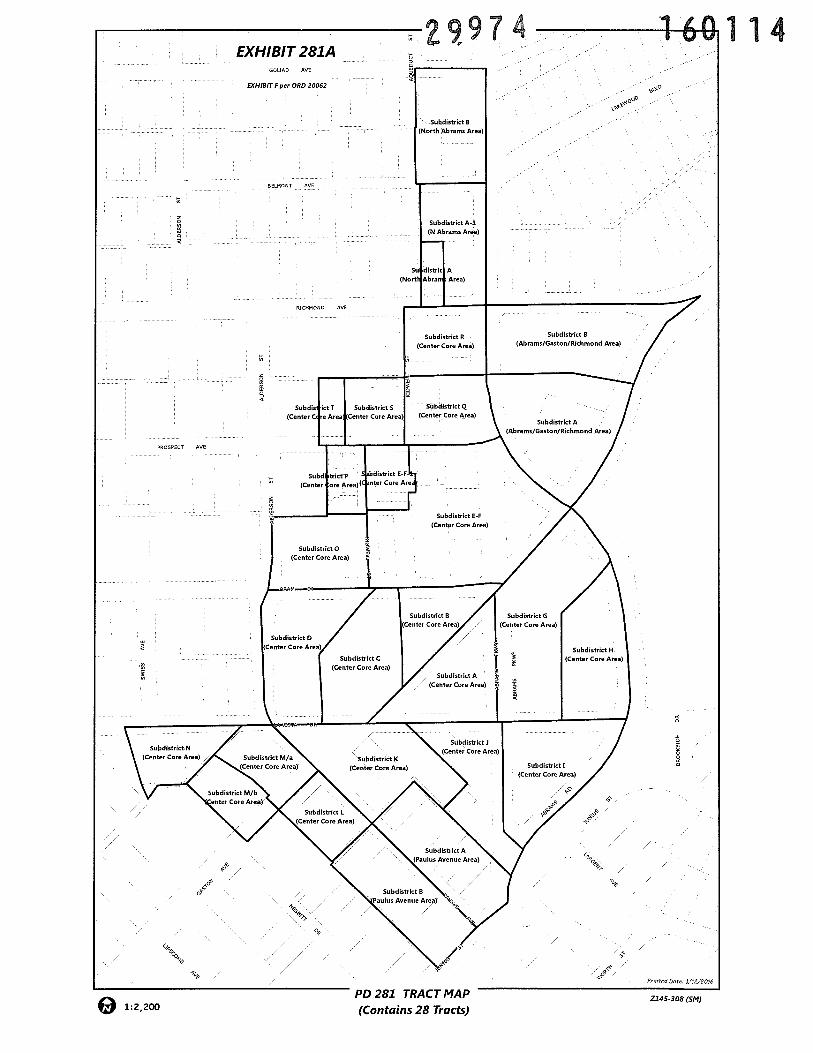
EXHIBIT 281AAVUAD AVE
EXHIBIT Fper ORD 20062
BELMONT AVE
AEEEMVNV AVE
rZ9974
VV
160114
PEVEPEET AVE
B
Subdin itt T Subdistrict S
ICenter C cc Area Center Care Area
Subdiatrict B-F
(Center Curt Area)
<V$
E/,
-B-S
PD 281 TRACTMAP(Contains 28 Tracts)
<VV
AVu:tcdtete L’EZEOIV
1:2,200Z145-30R (SM)
2997 160114
RICHMOND AVEMF-2(A)
0J)
U-i0-J
PROSPECT AVE
SUi624
pp 281(SubdiSt1t 0)
Center Core Area
PD 281(Subdistrict F-F)Center Core Area
1:2,400ZONING MAP
Z145-308
101112015Date:
Case no:
JAN 132016
160114
ORifiNANCE NUMBER
DATE PUBUSilED
___
OFFICE OF CITY SECRETARYP:\PROOF OF PUBLICATION.docx
29974
JAN 162016
ATTESTED BY:
PROOF OF PULIICATON - IIEGAL ADVIIRTIISRNC
The 1egd advertisement requfred for the mted ordhiauice w publithed inthe Dallas Morning News, the official newspaper of the city, as reqnfred bylaw, and the Dallas City Charter, Chapter XVH]I, Section 7.
DATE ADOPTED BY CITY COUNCiL
![Ministerial Ordinance [GMP]Title Ministerial Ordinance [GMP] Created Date 9/13/2005 10:08:18 AM](https://img.pdfslide.us/doc/110x75/5e5fcf3ab4c31c7d5d5c31a6/ministerial-ordinance-gmp-title-ministerial-ordinance-gmp-created-date-9132005.jpg)


![Ministerial Ordinance [QMS] - Global Medical Device Consulting...Title: Ministerial Ordinance [QMS] Created Date: 3/12/2015 9:29:46 AM](https://img.pdfslide.us/doc/110x75/5f20ac4d45a5736bc360cc75/ministerial-ordinance-qms-global-medical-device-consulting-title-ministerial.jpg)


![second supplemental ordinance [Ordinance]](https://img.pdfslide.us/doc/110x75/624f64d15eb5d005704c21d1/second-supplemental-ordinance-ordinance.jpg)